
Chapter 240Zoning
Article IGeneral
§ 240-1.1Authority
This Zoning Bylaw is adopted in accordance with the provision of MGL c. 40A.
§ 240-1.2Purpose
The purpose of this bylaw is to promote the health, convenience and welfare of the inhabitants and to accomplish all other objects of zoning.
§ 240-1.3Basic requirements
Added 1987; amended 1992, 2011, 2014
Notwithstanding any other provision of this bylaw, any building or structure or any use of any building, structure or premises is prohibited if it is injurious, obnoxious, offensive, dangerous, or a nuisance to the community or to the neighborhood by reason of the following:
| Noise | Gases |
|---|---|
| Vibrations | Dust |
| Concussion | Harmful fluids or substances |
| Odors | Danger of fire or explosion |
| Fumes | Smoke |
| Electronic interference | Excessive drawdown of groundwater |
| Debris/refuse | Lighting |
Or if it discharges into the air, soil, water or groundwater any industrial, commercial or other kinds of waste, petroleum products, chemicals, except pesticides registered and labeled under provisions of FIFRA and Chapter 132B of the Massachusetts General Laws, or pollutants unless the same are so treated before discharge as to render them harmless, or has any other objectionable feature detrimental to the neighborhood health, safety, groundwater, convenience, morals or welfare.
§ 240-1.4Nonconforming uses or structures
Added 1987; amended 1989, 1992, 2020
Purpose. It is the purpose of this bylaw to regulate the change, alteration, or expansion of any lawfully existing nonconforming use or structure. This bylaw is intended to and should be construed to restrict such changes, alterations, or expansions to the extent permitted under MGL c. 40A, § 6.
Continuation of nonconformity. Any structure or use lawfully in existence (or lawfully commenced prior to the first publication of notice of a public hearing concerning any adoption or amendment of a bylaw affecting such structure or use) may be continued; provided, however, that any structure or use that has been discontinued or abandoned continuously for a period of two years or more may not be reestablished and any future use of the buildings or land shall conform to this bylaw. Construction or operations under a building or special permit shall conform to any subsequent amendment of this bylaw unless the use or construction is commenced within a period of not more than six months after the issuance of the permit and, in cases involving construction, is continued through to completion as continuously and expeditiously as is reasonable.
Restoration. A lawfully existing nonconforming structure or use, if damaged or destroyed by fire or other accident, may be repaired or reconstructed within one year; provided, however, that such repair or reconstruction shall be within the same portion of the lot and shall conform to the extent possible with the requirements of the then-existing bylaw.
Amended 25 April 2023 (ATM by Art. 23)
Temporary uses. The Board of Appeals may permit a nonconforming temporary building or use incidental to the development of a neighborhood, such permit to be issued for an initial period of not more than two years and for renewal periods of not more than one year each.
[Deleted 1994; see § 240-5.5B(2).]
Repealed 1994
Change, alteration, or extension.
Except as provided in Subsection F(2), preexisting nonconforming uses or structures may not be changed, altered, or extended unless there is a finding by the permit granting authority designated in Subsection G of this bylaw that such change, extension or alteration is not substantially more detrimental to the neighborhood.
With respect to either (i) conforming structures on legally preexisting nonconforming lots which comply with all existing setback, height and dimensional requirements, or (ii) legally preexisting nonconforming structures on conforming lots, changes, alterations and extensions may be approved by the Building Inspector without the need for a finding by the Board of Appeals, provided that such changes, alterations or extensions also comply with all existing setback, height, and dimensional requirements and do not exceed 1,000 square feet.
Amended 25 April 2023 (ATM by Art. 23)
Procedure.
The Board of Appeals shall be the permit granting authority for any application for a finding under Subsection F, except the Planning Board shall be the permit granting authority with respect to applications concerning structures or uses in the business district.
The applicant for a finding hereunder shall file the original and two copies of his application for said finding with the Town Clerk as filing agent for the appropriate permit granting authority, and shall forthwith file a separate signed copy thereof for the records of the Town Clerk as required under MGL c. 40A, § 9. Upon its receipt of such application, the permit granting authority shall submit one copy thereof to the Select Board and one copy to either the Planning Board or the Board of Appeals, as the case may be, for its review and written recommendations. Each such Board shall make such recommendations as it deems appropriate and shall send copies thereof to the permit granting authority and the applicant. The failure of either Board to make written recommendations within 35 days from its receipt of such application shall be deemed to be lack of opposition thereto.
Amended 25 April 2023 (ATM by Art. 23)
Each application filed for a finding hereunder shall comply with the rules of the permit granting authority relative to the granting of special permits. The permit granting authority hereunder shall hear an application for a finding in full compliance with the time limitations and all other procedural requirements specified in Chapter 40A of the General Laws and Article VI of this bylaw.
§ 240-1.5Definitions
Amended 1973, 1979, 1980, 1981, 1982, 1983, 1996, 1998, 2011, 25 April 2023 (ATM by Arts. 3, 23), 29 April 2025 (ATM by Arts. 17, 19)
ACCESSORY BUILDINGS AND USES — An accessory building or accessory structure is a building or structure designed, constructed and/or devoted exclusively to a use subordinate to and customarily incidental to the principal use. An accessory use is a subordinate use of a building or other structure or of the premises which is customary in connection with the principal use and clearly incidental thereto and which does not constitute a conversion of the principal use of the premises to one not permitted. For Protected Use ADUs and Special Permit ADUs (formerly, Apartments), see Section 240-3.2.
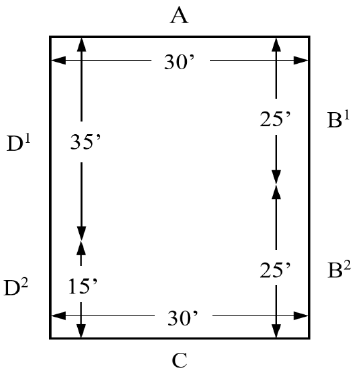
AVERAGE LOWEST FINISHED GRADE — A wall may be divided into sections. The average (mean) lowest elevation of the ground adjacent to all the sections of exterior walls of a building. It is calculated by determining the lowest elevation adjacent to each section of wall, weighting that elevation by the length of its adjacent section of wall (multiplying the elevation in feet by the length of the section of wall in feet), and dividing the sum of all weighted elevation figures by the total length of all exterior walls. The elevation figure used may be the height above mean sea level (msl), elevation relative to the top of the concrete foundation, or some other appropriate fixed point in the discretion of the building inspector. See illustration below:Low points at each section of wall (height above msl):A = 100'B1 = 95'B2 = 90'C = 90'D1 = 95'D2 = 90'Calculation: weighted elevations:A = 30 x 100 = 3,000B1 = 25 x 95 = 2,375B2 = 25 x 90 = 2,250C = 30 x 90 = 2,700D1 = 35 x 95 = 3,325D2 = 15 x 90 = 1,350Total weighted elevation: 15,000Total length of walls: 160Average lowest finished grade: 15,000/160 = 93.75
BUILDING — A combination of any materials, whether portable or fixed, having a roof supported by walls or columns and designed for the shelter, housing, or enclosure of persons, animals or property of any kind. The word "building" shall be construed, where the context so permits, as being followed by the words "or any part thereof."
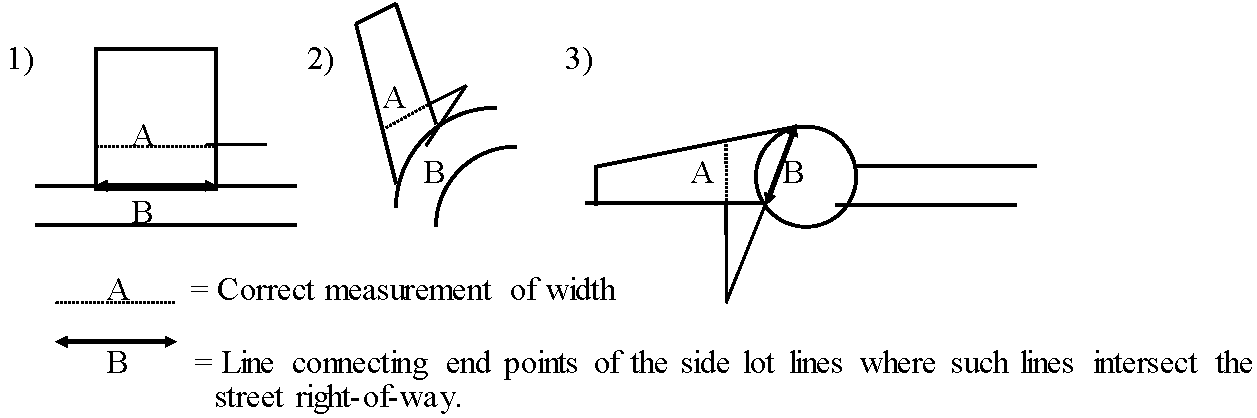
BUILDING LINE — A line which is the shortest distance from one side line of the lot to any other side line of the lot and which passes through any portion of the principal building and which differs by less than 45° from a line which connects the end points of the side lot lines at the point at which they intersect the street right-of-way.
COMMON DRIVEWAY — A driveway, or segment of a driveway, that provides access to two or more building lots by means of an easement, right-of-way or other mechanism over one or more lots.
DAY CARE CENTER — A place, whether known as a day nursery, nursery school, kindergarten, day camp, child play school, progressive school, preschool or other similar name, which receives for temporary custody, with or without stated educational purposes, during part or all of the day apart from their parents, three or more children under seven years of age and not of common parentage. The term shall not include kindergartens or nursery schools operated as part of an organized educational system or by a stated agency and shall not include a Sunday school conducted by a church.
DWELLING — A building which is designed for or redesigned for and/or used exclusively for human habitation, but not including a boardinghouse, a building devoted to the use of transient or overnight occupants, or a mobile home (however mounted) except as authorized by law.
DWELLING UNIT — A single housing unit providing complete, independent living facilities for one or more persons, including permanent provisions for living, sleeping, eating, cooking and sanitation.
EXEMPTED PROFESSIONAL USAGE — Any generally accepted professional or office type occupation, including but not limited to accounting, advertising, architecture, engineering, journalism, law, management consultation, sales representation, or stenography; but excluding the practice of medicine or personal care in any form, or any profession or business excluded from the definition of "home occupation" conducted only in a dwelling or building accessory thereto, employing only the inhabitants of the premises exclusive of persons not related by blood or marriage, and occupying no more than 200 square feet of floor space.
FARM — A. An establishment devoted (apart from residential use) wholly or predominantly to the commercial production of vegetables or other crops, fruit, dairy products, cattle, sheep, goats, poultry, eggs, maple products, or honey, or any combination thereof, including as an incident of the operation of such establishment the sale by its proprietor of its products only, either in their natural state or forming the major ingredients of processed commodities.B. The term "farm" does not include an establishment devoted (apart from residential use) wholly or predominantly to processing or distributing farm products dissociated from their production, and does not include a commercial greenhouse or fur farm or nursery or a piggery.
GROSS FLOOR AREA — The sum of the horizontal areas of the floor(s) of a building measured from the exterior face of exterior walls, but excluding unoccupied basement and attic space, and any space where the floor-to-ceiling height is less than six feet.
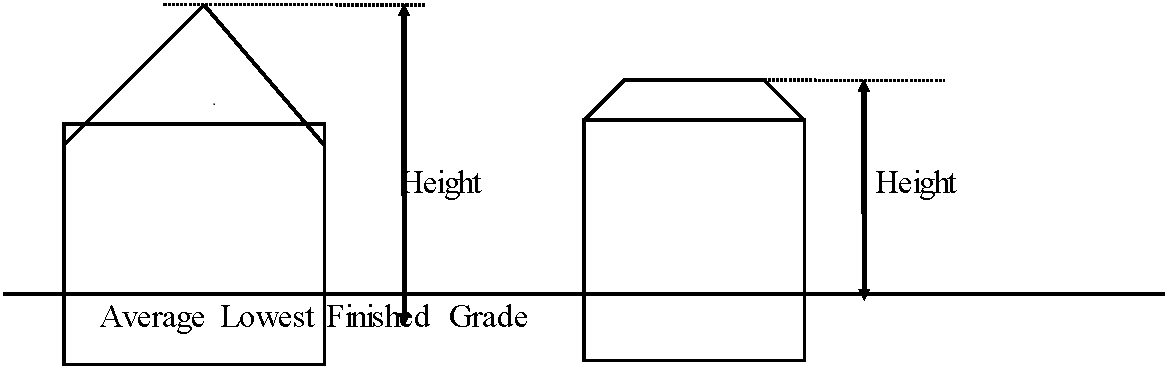
HEIGHT OF BUILDING OR STRUCTURE — The vertical distance between the average lowest finished grade adjacent to the exterior walls of a building to the highest point of a roof, as illustrated in the figure below:
HOME OCCUPATION — Occupations such as dressmaking, handicraft, preserving home cooking, conducted only in a dwelling or building accessory thereto by and employing only the inhabitants of the premises, and occupying not more than 200 square feet of floor area. The term "home occupation" does not include a beauty parlor, barbershop, convalescent or rest home, tourist home, massage parlor or similar establishment offering services to the general public.
HOUSEKEEPING UNIT — A separate housekeeping unit contained within a single-family detached dwelling or in an accessory building which has separate kitchen facilities for the storage, preparation or serving of food and separate living, sleeping or sanitary facilities.
LOT — A single area of land with definite boundaries ascertainable by recorded deed or plan.
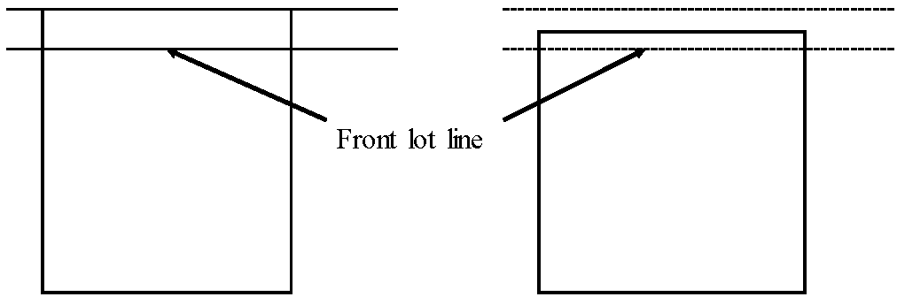
LOT LINE, FRONT — The line defining a street right-of-way, whether it be a public way or private way, where a street layout exists. Where no street layout exists, it shall be the line defining where the rights of others begin.
MULTIDWELLING — A building containing three or more dwelling units excluding Protected Use and Special Permit ADUs (formerly Apartments and Housekeeping Units). A multidwelling may be a series of attached or semidetached townhouses or row houses (dwelling units sharing one or more party walls and each having at least one floor at ground level with direct access to outside on two or more sides) or a garden apartment building (dwelling unit sharing a common entry hall or stairway).
NONCONFORMING BUILDING OR STRUCTURE — A building, structure or portion thereof which does not conform to the height and location regulations for the district in which it is located.
NONCONFORMING LOT — A lot which does not conform to the area, frontage, and width regulations for the district in which it is located.
NONCONFORMING USE — A use of a building, structure, or land which does not conform to the use regulations of the district in which it is located.
PARKING SPACE — An area not less than 8 1/2 feet in width and 20 feet in length for angle parking or 22 feet in length for parallel parking, exclusive of drives and maneuvering space.
PERSONAL CARE SERVICES — Assistance with one or more of those tasks related to bathing, dressing/grooming, ambulation, eating, toileting, reminding/assisting residents in taking medication and other similar tasks related to personal care needs either through physical support or supervision. Supervision includes reminding and/or observing residents while they perform activities.
PREMISES — A lot together with all buildings, structures, and uses thereon.
SETBACK — The shortest distance from the corresponding lot line to any part of a building or structure, including overhang but not including uncovered steps nor fences or walls less than six feet in height.
STREET — Any public way or way opened and dedicated to the public use which has not become a public way.
STRUCTURE — A combination of materials, other than a building, constructed or placed in a fixed location on the ground or attached to anything having a fixed location on the ground. The term structure shall include tennis courts, paddle tennis courts, and swimming pools, but shall not include walls or fences seven feet or less in height, utility poles and guys, patios at grade, or driveways.
WIDTH, LOT — A. A line which is the shortest distance from one side line of a lot to any other side line of such lot, provided that the extension of such line diverges less than 45° from a line, or extension thereof, which connects the end points of the side lot lines where such lines intersect the street right-of-way.B. In all three examples above, the extension of Line A diverges from the extension of Line B by less than 45°.
§ 240-1.6Prohibited uses
Article IIEstablishment of Districts
§ 240-2.1Classes of districts
Amended 1970, 1979, 1983, 1991, 29 April 2025 (ATM by Art. 17)
The Town of Sherborn is hereby divided into the following classes of district:
- Residence District A
- Residence District B
- Residence District C
- Residence District EA
Added 1991; amended 2008, 2017, 2023
- Residence District M
Added 1979; changed to EA in 2008
- Business District G
Added 1983
- Business District P
Added 1983
- Overlay Districts
- Flood Plain District
Added 1970
- Multi-Family Overlay District
Added 2025
- Wireless Communication Overlay Districts 1 and 2
Added 1977
- Large-scale ground-mounted solar photovoltaic facilities
Added 2011; amended 2023
§ 240-2.2Incorporation of Zoning Map
Amended 25 April 2023 (ATM by Art. 23)
All districts are located and bounded as shown on a map entitled "Zoning Map Town of Sherborn," as amended, and on file in the office of the Town Clerk. The Zoning Map, with all explanatory matter thereon, is hereby made a part of this bylaw.
§ 240-2.3District boundaries
Added 1970
Where the boundary lines are shown upon the Zoning Map within the lines of public or private ways, the center lines of the ways shall be the boundary lines.
Boundary lines located outside the lines of ways and shown approximately parallel thereto shall be regarded as parallel thereto, and dimensions shown in figures placed upon the Zoning Map between the boundary and the lines of ways are the distances in feet of the boundary lines from the lines of ways, such distances being measured at right angles to the lines of ways unless otherwise indicated.
In all cases which are not covered by other provisions of this subsection, the location of boundary lines shall be determined by the distance in feet, if given, from other lines or points on the Zoning Map, by the use of monuments or other identifiable points shown on the Zoning Map, or by the scale of the Zoning Map.
Boundary lines of Flood Plain Districts are indicated by dotted lines on the Zoning Map and where marked by a numerical figure followed by the letters msl, the location of the line shall coincide with the contour line at that number of feet above mean sea level.
§ 240-2.4Lots in two districts
Where a district boundary line divides a lot in a single or joint ownership at the time such line is adopted, the regulations for the less restricted portion of such lot shall extend not more than 30 feet into the more restricted portion, provided the lot has the required frontage on a street in the less restricted district.
Article IIIUse Regulations
§ 240-3.0Table of Use Regulations
| Use | RA | RB | RC | M+EA | B-G | B-P |
|---|---|---|---|---|---|---|
| 1Single-family home | A | A | A | A | A | A |
| 2Special permit ADU | P | P | P | P | P | P |
| 2AProtected use ADU | A | A | A | A | A | A |
| 3Renting rooms | A | A | A | A | A | A |
| 4Home occupation | A | A | A | A | A | A |
| 5Professional occupation | P | P | P | P | P | P |
| 6Produce farm | A | A | A | A | A | A |
| 7Farm, nonprofit | A | A | A | A | A | A |
| 8Farm, for-profit | A | A | A | A | A | A |
| 9Roadside stand | P | P | P | P | P | P |
| 10Greenhouse | P | P | P | P | P | P |
| 11Commercial stable | P | P | P | P | P | P |
| 11ACommercial stable (4 or fewer horses) | A | A | A | A | A | A |
| 12Religious | A | A | A | A | A | A |
| 13Educational | A | A | A | A | A | A |
| 14Private school | P | P | P | P | P | P |
| 14ADay care/child care center | A | A | A | A | A | A |
| 15Club, nonprofit | P | P | P | P | P | P |
| 16Club, for-profit | X | X | X | X | X | X |
| 17Office | X | X | X | P* | P | P |
| 18Restaurant | X | X | X | X | P | X |
| 19Retail | X | X | X | P* | P | X |
| 20Craft shop | X | X | X | X | P | P |
| 21Over 3 cars (garage space) | P | P | P | P | P | P |
| 22Service station | X | X | X | X | P | X |
| 23Repair shop | X | X | X | X | P | P |
| 24Public utility | P | P | P | P | P | P |
| 25Prohibitions (per § 240-1.3) | X | X | X | X | X | X |
| 26Two-family dwelling (duplex) | OS | OS | OS | P | X | X |
| 26AMultidwellings** | P | P | P | P | X | X |
| 27(Reserved) | ||||||
| 28Off-site septic systems | X | X | X | P | X | X |
| 29Accessory storage/parking of automobiles | P | P | P | P | NA | NA |
| 30Drive-through window | X | X | X | X | P | X |
| 31Municipal uses | A | A | A | A | A | A |
| 31AAccessory municipal use | P | P | P | P | P | P |
| 32Assisted living facility | X | X | X | P* | P | X |
| 33Registered marijuana treatment center | X | X | X | X | P | X |
| 34Outdoor entertainment | X | X | X | X | P | X |
A Allowed · P Permissive · X Prohibited · NA Not applicable · P* Provided Town Meeting preliminary development plan approval has been granted · ** This use is permissive as otherwise provided in § 240-4.5, 240-5.6 or 240-5.7 · OS Permissive as otherwise provided in § 240-4.5, Open space residential subdivision
§ 240-3.1Basic requirements
Amended 1975, 1978, 1979, 1980, 1981, 1982, 1988
Except as permitted by § 240-3.4, no building, structure, or land shall be adapted, constructed or used for any purpose or in any manner other than as permitted and set forth in § 240-3.2, Schedule of Use Regulations, of this bylaw.
| Designation | Meaning |
|---|---|
| Allowed | Use allowed by right. |
| Permissive | Use by special permit granted by the Board of Appeals, the Planning Board, or other permit granting authority as provided in this bylaw. |
| Prohibited | Use prohibited by this bylaw. |
Allowed uses and permissive uses granted by the Board of Appeals shall be in conformity with all dimensional requirements, off-street parking requirements, and any other pertinent requirements of this bylaw.
§ 240-3.2Schedule of Use Regulations
Amended 1970, 1973, 1978, 1983, 1985, 1987; added 1988, 1989, 1990, 1991, 1992, 1996, 1997, 1998, 2007, 2013, 2014, 2015, 2017, 2018, 2019, 25 April 2023 (ATM by Art. 23), 29 April 2025 (ATM by Arts. 17, 19), 23 April 2026 (ATM by Art. 16)
Single-family home - this use is allowed in all districts. Single-family detached dwelling together with Protected Use and Special Permit ADU(s) (formerly Apartment or Housekeeping Unit), accessory buildings, including a garage for not more than three automobiles. The number of such dwellings with such accessory buildings on any one lot shall not exceed the number which can be located thereon in conformity to § 240-4.3F.
Special Permit Accessory Dwelling Units (formerly, Apartment) for units larger than Protected Use ADUs but less than 1200 square feet - this use is permissive in all districts.
One additional dwelling unit accessory to a Single-family home, contained within the home or in an accessory building, provided:
The owner(s) of the premises shall live in either such unit or the primary dwelling unit;
The gross floor area of such unit shall not exceed 1,200 square feet;
Any special permit granted shall specify that the external character of the premises shall be that of a single-family residence;
The installation of such unit and any use thereof shall be permitted only upon the issuance of a special permit by the special permit granting authority in compliance with the procedures set forth in Article VI;
The applicant for a special permit for such unit shall file with the special permit granting authority such plans, specifications and other instruments concerning the proposed unit and the subsequent use thereof as the special permit granting authority may reasonably require by general rule or by request to the applicant;
No special permit for a unit shall be issued for a period of more than four years but may be renewable for like periods thereafter in accordance with the procedures set forth in Article VI.
Such unit may only be rented or licensed for occupancy for terms of more than 30 days. The intent of this article is to increase the diversity of housing stock in the Town that is available for people who want to reside in Sherborn.
A Special Permit ADU will not be allowed for Single-family homes already containing any other ADU.
Protected Use Accessory Dwelling Units. This use is allowed in all Districts. An attached or detached Accessory Dwelling Unit (ADU) that is located, or is proposed to be located, on in a Lot in a Single-Family Residential Zoning District and is protected by M.G.L. c. 40A, s. 1a, provided that only one ADU on a lot may qualify as a Protected Use ADU. An ADU that is nonconforming to Zoning shall still qualify as a Protected Use ADU if it otherwise meets this definition. Such unit may only be rented or licensed for occupancy for terms of more than 30 days.
Renting rooms - this use is allowed in all districts.
The renting of rooms or the furnishing of table board to not more than four persons not related by blood or marriage residing on the premises. This does not include transients or tourists. Rooms may only be rented or licensed for occupancy for terms of more than 30 days unless otherwise approved.
Home occupation - this use is allowed in all districts.
Home occupation or exempted professional usage as defined in § 240-1.5 conducted in a dwelling or building accessory thereto by a person residing on the premises, provided that:
Such use is clearly incidental and secondary to the use of the premises for residential purposes;
No person other than a resident of the premises is employed thereon in connection with such use, and no more than one member of the public is served at one time;
No offensive noise, vibration, smoke, dust, fumes, odors, heat, glare or unsightliness is produced;
There is no exterior storage of material or equipment, including the parking of commercial vehicles, and no other exterior indication of such use or variation from the residential character of the premises.
Professional occupation - this use is permissive in all districts.
Professional occupation, trade or craft customarily conducted in a dwelling or building accessory thereto by a person residing on the premises, provided that:
Such is clearly incidental and secondary to the use of the premises for residential purposes;
One person other than a resident of the premises may be employed thereon in connection with such use and no more than one member of the public is served at one time, except as otherwise permitted by the Board of Appeals;
No offensive noise, vibration, smoke, dust, fumes, odors, heat, glare or unsightliness is produced;
There is no public display of goods or wares and there are no signs except as permitted in § 240-5.2;
There is no exterior storage of material or equipment, including the parking of commercial vehicles and no other exterior indication of such use or variation from the residential character of the premises, except as otherwise expressly permitted by the Board of Appeals.
Roadside stand - this use is permissive in all districts except that this use is allowed if it satisfies all the requirements for the so-called agricultural exemption in MGL c. 40A, § 3.
Roadside stand for sale of local farm product provided that at least 50% by dollar volume is raised within the Town; such stand must be set back at least 50 feet from the center line of the street pavement.
Greenhouse - this use is permissive in all districts.
Commercial greenhouse or nursery.
Commercial stable - this use is permissive in all districts.
Unless otherwise permitted pursuant to § 240-3.4, commercial stabling of more than four horses, whether for (1) the conduct of a riding academy to provide instruction in horsemanship on, or off the premises under the direct supervision of an instructor, (2) boarding horses belonging to persons other than the owner of the premises, whether ridden on or off the premises, (3) boarding horses belonging to the owner or persons other than the owner and used for hire, or (4) the breeding, raising and training of horses for sale, provided that:
The permit shall indicate which of the above mentioned uses is covered;
The permit shall indicate the number of horses which may be stabled on the premises at any time;
The permit shall be limited to a maximum of two years, but may be renewed for like periods, subject to application and hearing as in the case of the original permit;
There shall be no sale of tack or other supplies;
A permit issued hereunder shall not relieve the owner from the necessity of obtaining a license from the Select Board under MGL c. 111, § 158 (so long as the Town has fewer than 5,000 inhabitants) or from the Board of Health under MGL c. 111, § 155 (if the Town has more than 5,000 inhabitants), shall not limit the powers of the Board of Health under MGL c. 111, § 31, or other applicable statutes or regulations, and shall not affect the power of the Department of Agriculture under MGL c. 128, §§ 2A and 2B.
Commercial stable - four or fewer horses - this use is allowed in all districts.
Commercial stabling of four or fewer horses, provided there is no sale of tack or other supplies.
Religious - this use is allowed in all districts.
Church or other religious purpose.
Educational - this use is allowed in all districts.
Educational purpose on land owned or leased by the commonwealth or any of its agencies, subdivisions or bodies politic or by a religious sect or denomination or by a nonprofit educational corporation.
Private school - this use is permissive in all districts.
Private elementary or secondary school, charitable or philanthropic institution, but not a hospital, rest home or sanitarium (except as permitted by Subsection 13 above).
Day care/child care center. This use is allowed in all districts. For definition, see MGL c. 15D, § 1A.
Club, nonprofit - this use is permissive in all districts.
Any public or private social, recreational or athletic club not conducted for profit and not containing sleeping quarters except for caretaker purposes. Miniature golf is prohibited.
Club, for-profit - this use is prohibited in all districts.
Any public or private social, recreational or athletic club conducted for profit and not containing sleeping quarters except for caretaker purposes. Miniature golf is prohibited.
Office - this use is prohibited in all Residence A, B and C Districts, permissive in all others, provided that in the EA Zone, Town Meeting preliminary development plan approval has been granted.
Offices for business or professional use.
Restaurant - This use is permissive in Business G District, prohibited in all others.
Restaurant or other place for serving food in premises designed for the service and consumption of food and beverages inside a building or on an adjoining patio; subject to the limitations as to hours, manner, and location of such outdoor service and consumption of any license issued by the Select Board pursuant to Chapter 140 of the General Laws.
Retail - this use is permissive in Business G District and in EA Districts for which Town Meeting preliminary development plan approval has been granted, prohibited in all others.
Bank or other financial institution, retail store or service establishment, the activities of which are the offering within the building of goods or services at retail for use within the building or off the premises.
Craft shop - this use is prohibited in residence districts, permissive in all others.
Shop for crafts such as silversmithing ceramics, woodworking, making or repairing lampshades, jewelry, or other similar handwork, or shop for the sale of antiques, works of art or craft material made on the premises, provided that no more than three persons are employed on the premises at any one time.
Over three cars - this use is permissive in all districts.
Garage space for more than three automobiles.
Service station - this use is permissive in Business G District, prohibited in all others.
Gasoline service station or automotive repair garage, provided that repairs shall be performed only indoors and that gasoline pumps and equipment shall be so located that vehicles to be serviced are entirely upon the premises and provided further that all activities are conducted in compliance with a site management plan prepared by the owner or operator of the site and approved by the Sherborn Board of Health.
Repair shop - this use is prohibited in residential districts, permissive in all others.
Repair shop for appliances and other light equipment, provided that no more than three persons are employed on the premises at any one time.
Public utility - this use is permissive in all districts.
Use of land for a public utility.
Prohibitions - these uses are prohibited in all districts.
In any district no use will be permitted that fails to comply with the basic requirements of § 240-1.3.
Two-Family Dwelling (Duplex) - This use is permissive in Residence EA Districts and Residence A, B, and C Districts where approved as part of an Open Space Subdivision, and prohibited in all other districts.
Single structure intended for dwelling by two families. Note: a Single Family Home with ADU(s) is not considered to be a Two-Family Dwelling for the purposes of zoning.
Multidwellings - This use is permissive in Residence EA Districts, prohibited in all other districts, except as otherwise provided in § 240-4.5, 240-5.6 or 240-5.7.
Three-family dwelling or larger. Multidwelling buildings must conform in all respects with the purposes and requirements set forth in § 240-5.6 or 240-5.7.
Low- or moderate-income apartment - this use is permissive in all districts.
Single-family detached dwelling, together with accessory buildings, containing in the dwelling or in an existing accessory building one additional housekeeping unit, or a building designed or used for any nonresidential purpose containing one additional housekeeping unit physically separated within the building from the nonresidential use, provided as follows:
Such unit shall meet the criteria for "Local Initiative Project" as defined in 760 CMR 56.00 (as the same may be amended from time to time), including the following:
The unit is to be "Low or Moderate Income Unit" as defined in 760 CMR 56.02 (as the same may be amended from time to time);
The unit is subject to use restrictions which, as a result of the special permit provided by this Subsection (27) permitting such unit, are a condition for the installation of such housekeeping unit (whether such installation results from new construction of the housekeeping unit, building conversion, adaptive reuse to permit use of an existing housekeeping unit, or substantial rehabilitation of the building for this purpose). Use restrictions means a contract, deed restriction, condition of the special permit provided by this Subsection (27), or other legal instrument as may be required by the special permit granting authority and as may be approved by the Office of Community Affairs within the Executive Office of Housing and Community and Development (which agency has been established pursuant to Chapters 23B and 6A of the General Laws of the Commonwealth), which use restriction restricts occupancy of "Low and Moderate Income Units" to persons with qualified incomes for a determinate period of time.
The initial period of such use restrictions is as long as the unit is operated as an apartment, but in no event less than five years; and
The owner(s) of the units agree to be subject to equal housing opportunity guidelines established by the Department of Community Affairs.
The gross floor area of such unit shall not exceed the lesser of 1,200 square feet or 30% of the gross floor area of the dwelling (including any addition thereto for such unit).
The installation of such unit and any use thereof shall be permitted only upon the issuance of a special permit by the special permit granting authority in compliance with the procedures set forth in Article VI of the Zoning Bylaw.
The special permit described in this Subsection (27) may be issued for the duration of such occupancy; provided, however, that the permit shall automatically expire on the second year anniversary of its issuance unless the period is extended for one or more additional two year periods upon the filing by the owner(s) of a sworn affidavit with the Town Clerk, with a copy to the Zoning Board of Appeals, certifying occupancy consistent with the special permit and this Subsection (27) of the bylaw.
The Inspector of Buildings may, in addition to other remedies, order removal of the separate kitchen facilities, equipment, fixtures, interior alterations, any separate metering of utilities, and any structural changes, or any or all of them, that were installed to create such unit, if the lawful use of such unit has expired or been terminated.
The applicant for a special permit for such unit shall file with the special permit granting authority such plans, specifications and other instruments concerning the proposed unit and the subsequent use therefor as the special permit granting authority may reasonably require by general rule or by request to the applicant.
After issuance of any special permit pursuant to this Subsection (27), the Select Board shall make application to the Department of Community Affairs for certification that the unit so permitted is a "Local Initiative Project" to count towards the Town's statutory obligations under Chapter 40B of the General Laws of the Commonwealth, all in accordance with the application procedures set forth in 760 CMR 56.00.
Off-site septic systems - this use is permissive in Residence EA District, prohibited in all others.
The use of land for septic systems or leaching fields for municipally owned buildings located beyond the boundaries of the lot or of the district.
The storage or parking of automobiles accessory to a business use, whether or not on the same lot as such business use, shall be subject to the granting of a special permit by the Planning Board, which may impose conditions on such use in addition to those required by § 240-5.1C and E of this bylaw.
Drive-through window - this use is permissive in the Business General District.
Any window, opening, chute, or other mechanism that is part of a building designed for the service of food or beverages for consumption off the premises, or the provision of any other goods or services, to retail customers while they remain in their motorized vehicle.
Municipal use - this use is allowed in all districts.
Any building, structure or parcel owned and/or operated by the Town and used for administration, public safety, recreation, health and welfare, or for any other public purpose or service provided by the Town. Any new municipal structure or building in any district shall be reviewed and approved in accordance with § 240-5.3A.
Accessory municipal use - this use is permissive in all districts.
The use of municipal property for private services through a lease, license or other contractual arrangement provided that:
Such use is clearly incidental and secondary to the use of the property for municipal purposes;
Such use occupies a maximum of 250 square feet;
The use provides a service that is necessary or convenient for Sherborn residents;
No offensive noise, vibration, smoke, dust, fumes, odors, heat, glare or unsightliness is produced;
There is no exterior storage of material or equipment, including the parking of commercial vehicles;
Such use in any district shall be reviewed and approved in accordance with § 240-5.3A.
Assisted living facility - this use is permissive in the Business G District and in EA Districts for which Town Meeting preliminary development plan approval has been granted, prohibited in all others.
A residential facility which provides a combination of housing and personal care services for persons 55 years of age or older, but not providing the level of care of a skilled nursing facility.
Outdoor entertainment.
Outdoor entertainment in the Business General District is subject to the granting of a special permit for a maximum of two years by the ZBA, which may impose conditions in addition to the following:
Sound emitted from the event must cease promptly at 10:30 p.m. on Fridays and Saturdays and 9:00 p.m. Sunday. Sundays before a Monday holiday shall follow the Saturday rules. Exceptions may be granted by the ZBA for weekdays during May through October as part of the special permit.
The measurement of sound or noise shall be made with a sound-level meter meeting the standards prescribed by ANSI S1.4 - 1971 Type 1 or Type 2. The instrument shall be maintained in calibration and good working order. A calibration check shall be made of the system at the time of any noise measurement. Measurements recorded shall be taken so as to provide a proper representation of the noise source. During measurement, the microphone shall be positioned so as not to create any unnatural enhancement or diminution of the measured noise. A windscreen for the microphone shall be used when required. Traffic, aircraft and other transportation noise sources and other background noises shall not be considered in taking measurements except where such background noise interferes with the primary noise being measured. The maximum acceptable sound level shall be 75 dBA as measured at the complainant location or that portion of the public way closest to the complainant.
The Zoning Board of Appeals shall adopt regulations specifying who provides the sound-level meter and the method of measurement, and may impose additional conditions on any special permit.
| TABLE OF USE REGULATIONS1 | ||||||
|---|---|---|---|---|---|---|
| Use2 | ||||||
| RA | ||||||
| 1) Single-family home | A | A | A | A | A | A |
| 2) Special permit ADU | P | P | P | P | P | P |
| 2A) Protected use ADU | A | A | A | A | A | A |
| 3) Renting rooms | A | A | A | A | A | A |
| 4) Home occupation | A | A | A | A | A | A |
| 5) Professional occupation | P | P | P | P | P | P |
| 6) Produce farm | A | A | A | A | A | A |
| 7) Farm, nonprofit | A | A | A | A | A | A |
| 8) Farm, for-profit | A | A | A | A | A | A |
| 9) Roadside stand | P | P | P | P | P | P |
| 10) Greenhouse | P | P | P | P | P | P |
| 11) Commercial stable | P | P | P | P | P | P |
| 11A) Commercial stable (4 or fewer horses) | A | A | A | A | A | A |
| 12) Religious | A | A | A | A | A | A |
| 13) Educational | A | A | A | A | A | A |
| 14) Private school | P | P | P | P | P | P |
| 14A) Day care/child care center | A | A | A | A | A | A |
| 15) Club, nonprofit | P | P | P | P | P | P |
| 16) Club, for-profit | X | X | X | X | X | X |
| 17) Office | X | X | X | P* | P | P |
| 18) Restaurant | X | X | X | X | P | X |
| 19) Retail | X | X | X | P* | P | X |
| 20) Craft shop | X | X | X | X | P | P |
| 21) Over 3 cars (garage space) | P | P | P | P | P | P |
| 22) Service station | X | X | X | X | P | X |
| 23) Repair shop | X | X | X | X | P | P |
| 24) Public utility | P | P | P | P | P | P |
| 25) Prohibitions (per § 240-1.3) | X | X | X | X | X | X |
| 26) Two-family dwelling (duplex) | OS | OS | OS | P | X | X |
| 26A) Multidwellings** | P | P | P | P | X | X |
| 27) (Reserved) | ||||||
| 28) Off-site septic systems | X | X | X | P | X | X |
| 29) Accessory storage/parking of automobiles | P | P | P | P | NA | NA |
| 30) Drive-through window | X | X | X | X | P | X |
| 31) Municipal uses | A | A | A | A | A | A |
| 31A) Accessory municipal use | P | P | P | P | P | P |
| 32) Assisted living facility | X | X | X | P* | P | X |
| 33) Registered marijuana treatment center | X | X | X | X | P | X |
| 34) Outdoor entertainment | X | X | X | X | P | X |
§ 240-3.3Living accommodations in nonresidential buildings
Amended 1973, 1991, 25 April 2023 (ATM by Art. 23), 23 April 2026 (ATM by Art. 16)
In a business district no living accommodations shall be permitted in a building designed or used for any nonresidential purpose except as expressly allowed or authorized by the Board of Appeals.
§ 240-3.4Special uses relating to agriculture, horticulture and floriculture
Added 1978; amended 2011, 2018
Purpose. The purpose of this section is to encourage farming and agricultural operations within the Town by permitting, in addition to the principal agricultural activities conducted upon the site, farm events using the farm grounds and accessory structures while also minimizing impacts on abutting properties.
Buildings and structures. Uses that qualify for the exemption for parcels of five acres or more or two acres or more as described in MGL c. 40A, § 3, relating to agriculture, horticulture, silviculture, viticulture, aquaculture or floriculture shall be uses allowed as of right provided that appropriate and reasonable screening of buildings and structures, such as hedges or fences, as determined by the Planning Board in light of the nature of the proposed use and the character of the surrounding area be provided. Such determination shall be made within 30 days based on a screening plan submitted as part of an application for a building permit, and referred to the Planning Board by the Building Inspector, in connection with any buildings or structure to be erected within 200 feet of a public way or lot line.
Farm events. Farm structures and grounds may also be used for events, including, but not limited to, educational conferences, fund-raisers for nonprofit entities, weddings and other personal recognition special events, as an accessory use clearly secondary and incidental to the principal use of the premises for agricultural purposes. Such events and uses are subject to site plan review in accordance with the requirements of § 240-5.3A of the Zoning Bylaw, and Chapter 380, Part 1, Article III, of the Site Plan Rules and Regulations regardless of the zoning district parking must be provided in accordance with the requirements of § 240-5.1 of the Zoning Bylaw. Such events and uses shall comply with all applicable state and local regulations and licensing requirements and the following:
Sound emitted from the event must cease promptly at 10:30 p.m. on Fridays and Saturdays and 9:00 p.m. Sunday. Sundays prior to a Monday holiday shall follow the Saturday rules. Exceptions may be granted by the Planning Board for weekdays during May through October as part of the site plan review.
The measurement of sound or noise shall be made with a sound-level meter meeting the standards prescribed by ANSI S1.4 - 1971 Type 1 or Type 2. The instrument shall be maintained in calibration and good working order. A calibration check shall be made of the system at the time of any noise measurement. Measurements recorded shall be taken so as to provide a proper representation of the noise source. During measurement, the microphone shall be positioned so as not to create any unnatural enhancement or diminution of the measured noise. A windscreen for the microphone shall be used when required. Traffic, aircraft and other transportation noise sources and other background noises shall not be considered in taking measurements except where such background noise interferes with the primary noise being measured. The maximum acceptable sound level shall be 75 dBA as measured at the complainant location or that portion of the public way closest to the complainant.
Amended 25 April 2023 (ATM by Art. 23)
Article IVDimensional Regulations
§ 240-4.1Basic requirements
Amended 1975, 1980, 2017, 2018, 25 April 2023 (ATM by Art. 23), 29 April 2025 (ATM by Art. 17)
Except as provided in § 240-4.4, every lot shall conform to the dimensional requirements set forth in §§ 240-4.2 and 240-4.3, and no building or structure, except fences six feet or less in height, in any district shall be built, located, enlarged or structurally altered which does not conform to such dimensional requirements.
Small accessory structure exception. A reduction to one-half of the values shown in § 240-4.2 for minimum required side and rear setbacks in the Residence A, B and C Districts shall apply to small accessory structures (including sheds, arbors, pergolas, pavilions, etc.) provided that they meet the following criteria:
The structure is not permanent in nature;
Its area is not more than 250 square feet;
Its maximum height is 1.5 stories to allow for a pitched roof, and its height shall not exceed the distance to the nearest lot line;
The structure shall not be used for the parking or storage of automobiles.
§ 240-4.2Schedule of Dimensional Requirements
Amended 1973, 1979, 1980, 1983, 1991, 1995, 1996, 25 April 2023 (ATM by Art. 23)
The Schedule of Dimensional Requirements is included as an attachment to this chapter.
| Minimum | Maximum | |||||||||
|---|---|---|---|---|---|---|---|---|---|---|
| District | Lot Sizeacres | Continuous Frontagefeet | Lot Widthfeet | Lot Depthfeet | Front Setbackfeet | Side Setbackfeet | Rear Setbackfeet | Heightstories | Heightfeet | Lot Coverage |
| RA Residence A | 1 | 150 | 150 * | — | 60 ** | 30 | 30 | 2.5 | 35 | — |
| RB Residence B | 2 | 200 | 200 * | — | 60 ** | 40 | 30 | 2.5 | 35 | — |
| RC Residence C | 3 | 250 | 250 * | — | 60 ** | 40 | 30 | 2.5 | 35 | — |
| M+EA Residence EA *** | 6 | 50 | Not applicable | 300 | 100 ** | 60 | 60 | 2.5 | 35 | — |
| B-G Business G | — | 100 | 100 * | 150 | 60 ** | 15 + | — | 2.5 | 35 | 33% |
| B-P Business P | — | 100 | 100 * | 150 | 60 | 30 | 30 | 2.5 | 35 | 33% |
- * Measured both at front setback line and at building line. Minimum lot width shall be continuously maintained between the frontage and the setback line. At no point between the setback line and the building line shall lot width be reduced to less than 50 feet.
- ** Measured from front lot line.
- *** With a special permit for multidwellings.
- + From abutting residence district.
- Projects allowed by an Overlay District shall follow the dimensional standards of that Overlay District.
- If any dimensional requirement applicable to a residential district in the foregoing schedule shall be held by judicial process to be invalid with respect to any property, that property shall thereafter be subject to the comparable dimensional requirement applicable to the residence district next preceding in the above alphabetical designation.
§ 240-4.3Special requirements
Amended 1979, 1980, 1991, 1996, 2009, 25 April 2023 (ATM by Art. 23), 29 April 2025 (ATM by Art. 17)
Land located in a way, whether public or private, shall be excluded in computing any lot area.
Height exceptions. Churches and municipal buildings may exceed the height limitation. Domes, cupolas, and other ornamental features, chimneys, ventilators, skylights, tanks, bulkheads, machinery, and other accessory features which are required above roofs may exceed the height limitation.
Number and location of dwellings on one lot. The number and location of dwellings (excluding ADUs, apartments, or housekeeping units with approved building permits) on any one lot shall be such that every dwelling thereon can be provided with sufficient land to form a separate lot which will itself be in full conformity to the regulations of this section and on which that dwelling will be in full conformity thereto; and upon alienation of any dwelling, it shall be provided with such a lot and every remaining dwelling on the original lot shall be left capable of being provided therewith. This section shall not apply to duplex or multidwelling buildings in a Residence EA District or Open Space Residential Subdivision for which a special permit has been granted pursuant to § 240-4.5 or 240-5.6, or to projects developed under the Multi-Family Overlay District in § 240-5.7.
Location of farm buildings. In a residence district no farm or poultry farm building shall be placed within 100 feet of the street sideline, except that a permanent building or structure used solely in connection with selling or offering for sale of farm products may be placed not less than 30 feet from the traveled portion of the street adjacent thereto.
Common driveways. Common driveways serving more than two building lots shall require a special permit from the Planning Board. Minimum requirements are that they be constructed in compliance with the Sherborn Driveway Bylaw, and each lot so served must have a common maintenance agreement recorded at the appropriate registry. Common driveways in existence and use as of September 30, 1995, shall not require a special permit unless the use is extended to one or more additional building lots.
§ 240-4.4Street frontage special permit
Added 1987; amended 1994, 1996, 25 April 2023 (ATM by Art. 23), 29 April 2025 (ATM by Art. 17)
Special permit required. Persons seeking relief from the minimum street frontage requirements of § 240-4.2 for any lot in a residence district may petition for a special permit granting same. For the purposes of this section, the lot having less than the minimum frontage required by § 240-4.2 is the "Section 4.4 lot." The remainder of the original lot must comply with § 240-4.2 (both before and after division) and is the "complying lot." No permit shall be granted under this section which does not result in both a Section 4.4 lot and a complying lot.
Grant by Planning Board. The Planning Board shall be the special permit granting authority for special permits authorized hereunder and shall hear and decide all properly submitted applications in compliance with the time limitations and other procedural requirements specified in Chapter 40A of the General Laws, this Zoning Bylaw (including without limitation § 240-6.2) and the Rules and Regulations of the Planning Board.
Board of Appeals comment. The Board of Appeals shall be the review board on all applications under this section. The Board of Appeals shall make such recommendations on each application as it deems appropriate, and shall send copies thereof to the Planning Board and the applicant. The failure of the Board of Appeals to make written recommendations within 35 days of receipt of an application shall be deemed to be lack of opposition thereto by the Board of Appeals.
Application.
Applications for permit under this section shall be prepared in triplicate, and filed with the Town Clerk as follows:
One copy for the records of the Town Clerk as required under MGL c. 40A, § 9.
One copy for the Town Clerk as the filing agent for the Planning Board.
One copy for the Town Clerk as filing agent for the Board of Appeals.
Upon receipt of said application, the Town Clerk shall forthwith transmit one copy to the Planning Board and one copy to the Board of Appeals.
Plans. Each petition for a special permit under this section shall be accompanied by a survey plan. Each survey plan submitted under this section shall:
Be prepared by a registered land surveyor in accordance with the rules of the Planning Board in such form as will be required for recording with the Middlesex South Registry of Deeds or filing with the Land Court.
Show all lot lines, existing and proposed, all existing buildings, structures, walls, wells, fences, rock ridges and outcroppings, watercourses, wetlands, septic systems, and floodplain areas, locations of all rights-of-way and easements on the lot and rights-of-way and easements on abutting land which are appurtenant to the lot and contours of the existing and finished grades of the access at two-foot intervals and contours of the balance of the lot at not more than five-foot intervals.
Show the location, width and center line of all existing and proposed access roadways, necessary drainage facilities, all filling, cutting and grading required for the construction thereof, and shall include a profile sheet showing the present and finished grades of such roadways.
Minimum requirements. The Planning Board shall not grant a special permit under this section unless all of the following requirements are satisfied:
Building limitations. Not more than one single-family dwelling is to be located on each of the Section 4.4 lot and the complying lot. No such single-family dwelling may be located on the proposed Section 4.4 lot at the time of application or approval of the special permit. The special permit shall contain a recorded restriction against further division of the Section 4.4 lot creating any additional building lots.
Adequate access. There will be adequate actual access from the street to the single-family dwelling located or to be located on the Section 4.4 lot and the complying lot, respectively. The access to the Section 4.4 lot shall be within the boundary lines of the Section 4.4 lot and not subject to any public or private easement or easements unless the Planning Board finds that such easement or easements will have no effect or only minimal effect on the proposed use of the access, in which case the Planning Board may waive the foregoing provision and include a finding supporting such waiver in its decision hereunder.
Additional setbacks.
Each building greater than 160 gross square feet on the Section 4.4 lot shall have the following minimum setback from each street and lot line (in lieu of those specified in § 240-4.2):
One hundred feet in Residence A.
One hundred twenty-five feet in Residence B.
One hundred fifty feet in Residence C.
The Planning Board may by special permit authorize an accessory structure, containing no dwelling units, having more than 160 gross square feet to be located closer to the side and rear setbacks, but not closer than the setbacks specified in § 240-4.2.
Underground utilities. All utilities will be installed underground unless the Planning Board specifically finds that above ground utilities will have minimal impact on adjacent lots.
Additional requirements. In determining whether or not to grant a special permit under this section and in determining what condition, if any, to impose on such a special permit, the Planning Board may consider additional circumstances relating to soil conditions, topography, lot history, wetlands, public safety and convenience, and public interest or other matters affecting the Section 4.4 lot and the complying lot, or the effect of the proposed division on the surrounding area and its inhabitants, including without limitation:
The extent to which the frontage provided is less than that required by § 240-4.2.
The possibility of future division or subdivision of the complying lot.
§ 240-4.5Open space residential subdivision
Added 1996; amended 2020
Purpose and intent: The primary purposes of this section are to:
Further the goals and recommendations of the Sherborn Master Plan and Open Space and Recreation Plan:
Preservation of open space, forests, and wildlife habitat.
Protection of clean groundwater resources, including aquifers, surface water bodies, streams and wetlands.
Reduction of energy consumption and greenhouse gas emissions, and mitigation of the effects of climate change.
Preservation of agricultural land use.
Establish open space subdivision design as a preferred alternative to conventional subdivisions, in order to consume less open land and preserve environmental resilience while providing for present and future housing needs;
Enable landowners to realize equity from development of a limited percentage of their land while preserving conservation, agricultural, forestry or recreational uses on the majority of the property;
Expedite the permitting of projects that fulfill the objectives and requirements of this bylaw;
Facilitate the construction and maintenance of housing, streets, utilities, and public services in a more economical and efficient manner while minimizing the total area of disturbance of the site; and
Promote the incorporation of low-impact development and green infrastructure features into development designs.
Amended 25 April 2023 (ATM by Art. 23)
Definitions:
APPLICANT — Shall mean an owner, his agent or representative, or his assigns, that are responsible for submission of a subdivision development plan to Town officials.
APPROVAL NOT REQUIRED (ANR) — Shall mean a process of creating building lots in accordance with MGL c. 41, § 81P, as may be amended from time to time, by inter alia division of land on an existing public way, in which each new lot fulfills the minimum frontage requirements of the relevant zoning district.
BOARD — Shall mean the Planning Board.
CONVENTIONAL SUBDIVISION — Shall mean a division of land into two or more lots in such a manner as to constitute "subdivision" as defined in MGL c. 41, § 81L, as amended from time to time, and in which minimum lot size is that required for a single-family home in the zoning district, as defined in Zoning Bylaw § 240-4.2.
DWELLING UNIT — Shall mean a group of rooms or a structure designed, constructed and/or equipped exclusively for use as a complete living unit for one family, including living, sleeping, cooking and sanitary facilities, and which is directly accessible from the outside without passing through any other dwelling unit.
Amended 25 April 2023 (ATM by Art. 23)
GREEN INFRASTRUCTURE — Shall mean the vegetation and forests that provide services to the community such as groundwater filtering and retention, aquifer recharge, carbon sequestration and temperature control.
HOMEOWNERS' ASSOCIATION — Shall mean the corporation, trust, or association owned by the unit owners within an open space subdivision and used by them to manage and regulate their affairs, including any commonly owned land or facilities.
Amended 25 April 2023 (ATM by Art. 23)
LOW-IMPACT DEVELOPMENT — Shall mean land development and building practices that minimize environmental impacts by preserving or adding vegetation including trees, and promoting groundwater retention and recharge through design features.
Amended 25 April 2023 (ATM by Art. 23)
LOW-IMPACT DRAINAGE SYSTEM — Shall mean a stormwater management system that maximizes maintenance of clean groundwater resources through natural filtering, retention and recharge.
Amended 25 April 2023 (ATM by Art. 23)
OPEN SPACE SUBDIVISION — Shall mean a division of land into two or more residential lots in such a manner as to constitute "subdivision" as defined in MGL c. 41, § 81L, as amended from time to time, and that (a) permanently preserves at least 60% of the land in a natural, scenic or open condition or in agricultural, farming or forest use; (b) preserves the significant natural, cultural, and historic features of the land; (c) concentrates residential development, through design flexibility and reduced dimensional requirements, in order to preserve those features; and (d) calculates the number of dwelling units allowed up front by formula.
Amended 25 April 2023 (ATM by Art. 23)
OWNER — Shall mean the owner or owners of record of all land included within the subdivision as shown by the records of the Registry of Deeds for the Southern District of Middlesex County or the Middlesex South Registry District of the Land Court.
PROTECTED OPEN SPACE — Shall mean land that is permanently preserved in a natural, scenic or open condition or in agricultural, farming or forest use, by conservation restriction or other legal means.
UPLANDS — Shall mean a land area that is not under federal, state or local wetland or floodplain jurisdiction.
Amended 25 April 2023 (ATM by Art. 23)
YIELD PLAN — Shall mean a calculation of the number of dwelling units allowed in a specific open space subdivision, using the method described in Subsection D below.
Applicability:
Open space subdivisions are allowed by right under zoning and may be proposed anywhere within the R-A, R-B and R-C Districts. Open space subdivisions shall be subject to the requirements of the Sherborn Zoning Bylaw except as noted otherwise in this (§ 240-4.5) section and the Subdivision Rules and Regulations of the Sherborn Planning Board as applicable.
Amended 25 April 2023 (ATM by Art. 23)
Subsection A above applies only to subdivisions of land as defined in MGL c. 41, § 81L, and not to construction of homes on individual house lots that existed prior to the date of adoption of this bylaw, or to house lots created through the "approval not required" (ANR) process with frontage on public ways in existence at the date of adoption of this bylaw.
All subdivision applications received after the effective date of this bylaw shall comply with the provisions of this open space subdivision section, unless the Planning Board allows a development that deviates from the requirements of this section by special permit. Such deviations, including conventional subdivision designs, may be approved if the applicant demonstrates that the proposed alternative development configuration provides protection of the site's environmental resources and fulfills the purposes of this section as well or better than an open space subdivision.
Amended 25 April 2023 (ATM by Art. 23)
If the proposed open space subdivision involves a special permit(s) for one or more common driveways, or any other use that requires a special permit, the proceedings for all such special permits and the site plan review for lot configuration shall occur in one consolidated special permit proceeding before the Planning Board.
Yield: allowable dwelling units.
Number of dwelling units allowed.
The base maximum number of residential units allowed in an open space residential subdivision is calculated by a formula based upon the net developable acreage of the parcel. This formula takes into account site-specific development restrictions and limitations that make some land unsuitable for development, or less suitable for development than other land. This calculation involves two steps, calculating the net acreage and dividing by the minimum conventional lot acreage in the zoning district.
To determine net acreage, subtract the following from the total (gross) acreage of the parcel:
Half of the acreage of land with slopes of 20% or greater;
The total acreage of land subject to easements or restrictions prohibiting development, lakes, ponds, vernal pools, 100-year floodplains as most recently delineated by FEMA, Zone I and A around public or private water supplies, and all wetlands as defined in MGL c. 131, § 40, and any state or local regulations adopted thereunder; and
Ten percent of the remaining site acreage after the areas of Subsection (D)(1)(b)[1] and [2] are removed, to account for subdivision roads and infrastructure.
The factors named above are included for net acreage calculation purposes only and do not convey or imply any regulatory constraints on development siting that are not contained in other applicable provisions of law, including this Zoning Bylaw.
The maximum number of allowable dwelling units in an open space subdivision on the parcel is determined by dividing the net acreage by the required acreage for a house lot in the zoning district. Fractional units shall be rounded down to the nearest whole number. The required acreage for each district is:
| District | Required Acreage per Unit |
|---|---|
| R-A | 1 |
| R-B | 2 |
| R-C | 3 |
"An open space subdivision shall have no more residential units than the number of units that would be allowed in a conventional subdivision on the parcel of land that is the subject of the application, documented by a conventional subdivision general layout as defined in the Planning Board Rules and Regulations, submitted by the applicant."
Parcels in more than one zoning district. For parcels in more than one district, the allowable residential unit count for each district shall be computed separately first. These unit count totals shall be added together and then rounded down to the nearest whole number as above.
General requirements:
Open space subdivision layout. The developed areas and protected open space shall be placed within the parcel in a manner that best fits the characteristics of the land and the purposes of this bylaw, in particular the protection of clean groundwater resources and environmental resiliency.
Housing types.
Subdivision residential dwelling units shall be single-family structures. Duplexes may be allowed by special permit, if designed to resemble single-family homes. Duplexes will be considered as two residential dwelling units.
Single-family structures or duplexes will be located on individual lots. Condominium arrangements on a shared lot, or a combination of individual lots and shared condominium lots, may be allowed by special permit in cases where such arrangements best serve the conservation purposes of this bylaw on the specific parcel.
Dimensional requirements: With the exception of building height, the dimensional requirements of § 240-4.2 of this bylaw do not apply to open space subdivision developments. Lot size and shape, residential unit placement, lot width, and other dimensional requirements within an open space subdivision are subject to the following guidelines and limitations:
Objectives. Residential units shall be located and arranged in a way that advances the open space and resource conservation objectives of this bylaw, i.e., to protect: views from roads and other publicly accessible points; farmland; wildlife habitat; large intact forest areas; hilltops and steep slopes; ponds, wetlands and groundwater resources; and other sensitive environmental resources.
Amended 25 April 2023 (ATM by Art. 23)
Monumentation. Monumentation of a type consistent with the use of the open space, and approved by the Planning Board, shall clearly delineate the boundaries of the protected open space in a manner that facilitates monitoring and enforcement.
Area. There is no required minimum lot size for zoning purposes. The limiting factors on lot size and placement for each single-family structure or specially permitted duplex in an open space subdivision are the need for 1) adequate water supply and sewage disposal for each residential unit, 2) protection of the quality and quantity of current and future groundwater resources on abutting properties, 3) prevention of negative impacts on wetlands on or near the subdivision, and compliance with the other provisions of this bylaw.
Infrastructure. Board of Health regulations regarding water supply protection and the disposal of wastewater, and Conservation Commission regulations regarding wetland protection, shall apply. Protection of clean water resources will be a primary factor in Planning Board decisions regarding placement of residential units and overall subdivision design. For any proposed subdivision design, in particular layouts that may require clustered or shared septic systems, the Planning Board shall forward concept sketches and/or preliminary plans to the Conservation Commission and Board of Health for comment. Clustered or shared septic systems are likely to require setbacks greater than standard single-family systems to prevent negative impacts on wetlands, drinking water wells and groundwater, or environmental resiliency, and therefore may require specific analyses to help determine such setbacks, and subsequent monitoring to determine their effectiveness.
Frontage and vehicular access. Open space subdivision lots have no numerical requirement for lot frontage. Any open space subdivision lot must have functional vehicular access only to the internal subdivision road. Vehicular access via a common driveway to an internal subdivision road (but not to an existing road) may be approved by special permit. Open space subdivision lots that have frontage on an existing public road must maintain a wooded or appropriately vegetated buffer zone between the existing road right-of-way and the subdivision buildings, of sufficient length and depth to visually screen the buildings on that lot and preserve the scenic quality of the road.
Amended 15 May 2021 (ATM by Art. 14), 25 April 2023 (ATM by Art. 23)
Setbacks. The minimum setback of any building from an existing public road shall be 100 feet. The minimum setback of any building from an internal open space subdivision road shall be 30 feet. The minimum setback of any building from the property line of an abutting property not part of the open space subdivision shall be 60 feet. The minimum distance between residential buildings within the open space subdivision shall be 30 feet. The minimum distance between an open space subdivision residential building and an abutter's residential building shall be 100 feet. Accessory sheds as defined in Zoning Bylaw § 240-4.1A shall be allowed, provided that they are at least 10 feet from the adjacent internal subdivision lot line, and set back from the lot lines of abutting nonsubdivision properties as specified in § 240-4.1A.
Amended 25 April 2023 (ATM by Art. 23)
Open space requirements:
Minimum area.
A minimum of 60% of the total gross acreage of the land area of the open space subdivision shall be set aside as permanently conserved open space. At least half of the open space shall be "uplands" as defined in Subsection B.
No more than 10% of the required open space may be utilized for common water supply wells and associated infrastructure, subsurface leaching fields and other underground components of wastewater systems, rain gardens, constructed wetlands, and other decentralized stormwater management systems consistent with low-impact development, that serve the open space subdivision, provided that the land so utilized is contiguous with undisturbed area(s) of protected open space. Treated stormwater may be discharged into the protected open space as part of an approved low-impact stormwater management plan. All protected land must be shown on approved plans.
Amended 25 April 2023 (ATM by Art. 23)
Contiguity of open space. Preserved open space shall be contiguous to the greatest extent practicable. Noncontiguous areas of open space may be allowed if they are shown to provide better protection of areas of high conservation value or to provide continuity with open space on adjacent lands. In such cases, applicants shall attempt to connect these resource areas to the greatest extent practicable through the use of vegetated corridors. Open space will still be considered contiguous if it is crossed by a shared driveway, roadway, or an accessory amenity such as a paved pathway or trail, as long as a functional wildlife corridor is maintained. If the open space is maintained for agricultural uses, open space areas will be considered contiguous if separated by a barn or storage shed.
Permanent conservation of the required open space.
Any land required to be set aside as open space, voluntarily preserved in excess of that required, or conserved as a condition of site plan approval, shall be permanently protected pursuant to Article 97 of the Articles of Amendment to the Constitution of the Commonwealth of Massachusetts or a perpetual restriction under MGL c. 184, §§ 31 to 33. Unless conveyed to the Conservation Commission, the required open space shall be subject to a permanent conservation, watershed, or agricultural preservation restriction conforming to the standards of the Massachusetts Executive Office of Environmental Affairs, Division of Conservation Services, or Department of Agricultural Resources in accordance with MGL c. 184, §§ 31 to 33, approved by the Planning Board and Select Board and held by the Town of Sherborn, the Commonwealth of Massachusetts, or a nonprofit conservation organization qualified to hold conservation restrictions under MGL c. 184, §§ 31 to 33. Any proposed open space that does not qualify for inclusion in a conservation restriction, watershed, or agricultural preservation restriction or that is rejected from inclusion in these programs by the Commonwealth of Massachusetts shall be subject to a restrictive covenant in perpetuity under MGL c. 184, §§ 26 to 30, which shall be approved by the Planning Board and Select Board and held by or for the benefit of the Town of Sherborn.
The restriction shall specify the prohibited and permitted uses of the restricted land, which would otherwise constitute impermissible development or use of the open space, consistent with the allowable and prohibited uses subsections of this section and any permits. The restriction may permit, but the Planning Board may not require, public access or access by residents of the development to the protected land.
Amended 25 April 2023 (ATM by Art. 23)
Timing. Any restriction or other legal document necessary to permanently conserve open space as required herein shall be recorded prior to the release of any lots in a subdivision or prior to the issuance of any building permits.
Allowable use of the open space. Such land shall be perpetually kept in an open state, preserved exclusively for the purposes set forth herein and in the deed and/or in the restriction, and maintained in a manner which will ensure its suitability for its intended purposes. Proposed use(s) of the open space consistent with this section shall be specified in the application.
The open space shall be used for wildlife habitat and conservation and/or the following additional purposes or a combination of these uses to the extent allowed by Massachusetts General Laws, and shall be served by suitable access for such purposes: historic preservation, outdoor education, forestry and passive recreation. Agriculture or horticulture shall be allowed if the land was in such use at the time of approval of the definitive plan. A portion of the open space may be used for new agriculture, horticulture or community gardens, provided that only organic methods are employed.
The Planning Board may permit a small portion of the open space, not to exceed 5%, to be paved or built upon (using permeable pavement and other means of retaining natural hydrology) for purposes accessory to the dedicated use or uses of such open space, so long as the conservation values of the open space are not compromised. Examples of such purposes are parking to facilitate public access for passive recreation, informational kiosks, pedestrian walks, ADA access features, and bike paths. Construction of barns or other farm structures will be allowed on 5% of the protected open space that is in agricultural or horticultural use as defined by MGL c. 128, § 1A.
The open space may be used as the land subject to a restriction for the purpose of an aggregate calculation under Title 5, 310 CMR 15.000 of the State Environmental Code, MGL c. 21A.
Prohibited use of the open space. The open space within an open space subdivision shall be perpetually kept in an open state, preserved exclusively for the purposes set forth in Subsection G(5) of this bylaw, and maintained in a manner that will ensure its suitability for its intended purposes. Expressly prohibited uses, if not specifically permitted as an allowable use, include but are not limited to the following:
Constructing or placing of any temporary or permanent building, tennis court, landing strip, mobile home, swimming pool, asphalt or concrete pavement, sign, billboard or other advertising display, antenna, utility pole, tower, conduit, line or other temporary or permanent structure or facility on, above, or under the open space that is not in conformance with an authorized use of the open space (e.g., fencing, barn or other structure associated with agriculture);
Amended 25 April 2023 (ATM by Art. 23)
Mining, excavating, dredging, or removing soil, loam, peat, rock, gravel or other mineral resource or natural deposit, unless necessary to install infrastructure that is part of the approved plan;
Placing, filling, storing, or dumping of soil, refuse, trash, vehicles or parts thereof, rubbish, debris, junk, waste, or other substance or material whatsoever or the installation of underground storage tanks;
Cutting, removing, or destroying of trees, grasses or other vegetation unless in conformance with an allowed use such as agriculture, forestry, recreation, maintenance of healthy natural ecosystems and suppression of invasive species, or installation of infrastructure that is part of the approved plan;
Subdivision; neither further division of the protected open space into lots or the use of the protected open space toward any further building requirements on this or any other lot is permitted;
Activities detrimental to drainage, flood control, water conservation, water quality, erosion, soil conservation, or archeological conservation;
Purposefully introducing or allowing the introduction of species of plants and animals recognized by the Executive Office of Energy and Environmental Affairs to pose a substantial risk of being invasive or otherwise detrimental to the native plant and animal species and plant communities on the property;
The use, parking or storage of motorized vehicles, including all-terrain vehicles (ATVs), snowmobiles, motorcycles, and campers, except in conformance with an authorized use of the open space, ADA accessibility, or as required by the police, firefighters, or other governmental agents in carrying out their duties; and
Any other use or activity which would materially impair conservation interests unless necessary in an emergency for the protection of those interests.
Ownership of the open space:
At the applicant's discretion and the grantee's acceptance, the open space may be owned in fee by:
A private owner for agricultural, horticultural, forestry or any other purpose not inconsistent with the conservation or agricultural restriction;
A nonprofit organization or agency of the commonwealth, with their consent, whose principal purpose is the conservation of open space for any of the purposes set forth herein;
Amended 25 April 2023 (ATM by Art. 23)
The Town of Sherborn, with the consent of the Select Board, under management of the Town Forest or Conservation Commission, with their consent; or
A homeowners' association (HOA) as defined herein, owned jointly or in common by the owners of lots or units within the open space subdivision.
Amended 25 April 2023 (ATM by Art. 23)
If ownership option H(1)(d) is selected the following shall apply:
The documents organizing the HOA shall be drafted by the applicant and approved by the Planning Board before final approval of the open space subdivision development, recorded prior to the issuance of building permits, comply with all applicable provisions of state law, and pass with conveyance of the lots or units in perpetuity. Each individual deed, and the deed, trust, or articles of incorporation, shall include language designed to effect these provisions.
Membership must be mandatory for each property owner, who must be required by recorded covenants and restrictions to pay fees to the HOA for taxes, insurance, and maintenance of common open space, private roads, and other common facilities.
The HOA must be responsible in perpetuity for liability insurance, property taxes, the maintenance of recreational and other facilities, preservation of the open space in accordance with this bylaw, private roads, and any common driveways.
Property owners must pay their pro rata share of the costs in Subsection H(2)(c) above, and the assessment levied by the HOA must be able to become a lien upon individual properties within the open space subdivision.
The HOA must be able to adjust the assessment to meet changed needs.
The applicant shall make a conditional grant to the Town of Sherborn, Sherborn Conservation Commission, binding upon the HOA, of the fee interest to all open space to be conveyed to the HOA. Such offer may be accepted by the Conservation Commission, at the discretion of the Select Board, upon the failure of the HOA to take title to the open space from the applicant or other current owner, upon dissolution of the HOA at any future time, or upon failure of the HOA to fulfill its maintenance obligations hereunder or to pay its real property taxes on the open space.
Ownership shall be structured in such a manner that real property taxing authorities may satisfy property tax claims against the open space lands by proceeding against individual property owners in the HOA and the dwelling units they each own.
Sherborn Town Counsel must find that the HOA documents presented satisfy the conditions in Subsections H(2)(a) through (g) above, and such other conditions as the Planning Board shall deem necessary.
Selection of ownership option H(1)(a), (b) or (d) requires:
The conveyance of a conservation restriction as outlined herein; and
The granting of an access easement over such land sufficient to ensure access for Sherborn Town officials to ensure its perpetual integrity and maintenance as agricultural, conservation, or recreation land. Such easement shall provide that in the event the owner fails to maintain the open space in reasonable condition, Town officials may, after notice to the lot owners and any grantee of a restriction, and after Select Board public hearing, enter upon such land to maintain it in order to prevent or abate a nuisance.
Maintenance:
Maintenance standards. The Planning Board shall require the establishment of ongoing maintenance standards as a condition of development approval to ensure that utilities are properly maintained and the open space land is not encroached upon, or used for storage or dumping of refuse, junk, or other offensive or hazardous materials. Such standards shall be enforceable by the Town against any owner of open space land, including an HOA.
Enforcement of maintenance standards.
If the Select Board finds that the maintenance provisions are being violated to the extent that the condition of the utilities or the open land constitutes a public nuisance, it may, upon 30 days' written notice to the owner/grantee, enter the premises for necessary maintenance, and the cost of such maintenance by the Town shall be assessed proportionally against the landowner or, in the case of an HOA, the owners of properties within the subdivision, and shall, if unpaid, become a property tax lien on such property or properties.
Amended 25 April 2023 (ATM by Art. 23)
Pursuant to MGL c. 40, § 58, Sherborn may file a lien against the subdivision lot or lots to ensure payment for such maintenance. Pursuant to MGL c. 40, § 57, Sherborn may also deny any application for, or revoke or suspend a building permit or any local license or permit, due to neglect or refusal by any property owner to pay any maintenance assessments levied.
Submission requirements: In order to enable the Planning Board to determine whether or not a proposed open space subdivision design (or alternative subdivision development requiring a special permit that deviates from the requirements for open space design) satisfies the purposes and standards of this open space subdivision section of the Zoning Bylaw and the Subdivision Rules and Regulations of the Planning Board, an applicant must present sufficient information on the environmental and open space resources for the Board to make such a determination.
§ 240-4.6Planned unit development special permit
Purpose. The purpose of this section is to provide by special permit for an alternative to traditional business development that enhances the rural, village atmosphere of the Town Center or otherwise provides increased public benefits by permitting greater flexibility in site design and mix of uses than is otherwise allowed in this bylaw. The intent of this zoning provision is to:
Provide for greater integration of land uses within the Town Center;
Preserve historic buildings by providing economically viable uses for them;
Relieve congestion by providing linked access and parking;
Perpetuate and enhance the appearance of Sherborn's traditional small town New England center; and
Promote better building location and overall site planning than may be possible under traditional zoning, while retaining standard setbacks from other properties not part of the planned unit development.
Special permit for planned unit development. Persons seeking to develop property as a planned unit development may apply for a special permit under this § 240-4.6 in accordance with MGL c. 40A, § 9. Applicants are strongly encouraged to meet with the Planning Board and other Town boards informally prior to submitting an application for special permit.
Minimum requirements.
No property shall be the subject of an application for a special permit under this section unless at least 25% of such property is within the Business G or Business P Districts and unless such property is at least 60,000 square feet in total area and has frontage within a Business G or Business P District.
The Planning Board may, by issuing a special permit, vary the otherwise applicable dimensional requirements of § 240-4.2, other than provisions as to height and maximum lot coverage, provided that a special permit may not issue for a proposed planned unit development unless the applicant shows:
A front yard setback of at least 20 feet, or if less, no less than that of a preexisting nonconforming building on the lot;
Amended 25 April 2023 (ATM by Art. 23)
Pedestrian linkage(s) to abutting properties that is (are) well-defined and of a design and quality that will encourage significant use;
Amended 25 April 2023 (ATM by Art. 23)
Vehicular linkage with abutting business parcels;
Significant public amenities on- or off-site which may include, but are not limited to, the following: landscaped open area with walkways, benches, fountains, monuments, and/or other features; bike racks and/or separate bicycle access; hitching posts and/or separate horse access; drinking fountains; awnings, or pavilions; or other suitable amenity; and
Amended 25 April 2023 (ATM by Art. 23)
Building designs that are complementary in scale and style to those of abutting properties and that are, in general, appropriate for a small New England village.
Notwithstanding anything in § 240-3.2, Schedule of Use Regulations, to the contrary, a planned unit development may include anywhere within its boundaries any mix of uses currently allowed or permitted in the Business G or Business P Districts except:
Such mix may not include, by building square footage, more than 50% retail uses;
Service stations shall be prohibited;
No individual retail outlet may exceed 2,500 square feet of gross interior floor area, which area shall not include mechanical, storage or kitchen space; and
Each retail area shall have direct access to a sidewalk, plaza, common or similar outdoor pedestrian connection to the other retail spaces on the site.
Amended 25 April 2023 (ATM by Art. 23)
Planning Board as special permit granting authority. The Planning Board shall be the special permit granting authority for special permits authorized in this section, and shall hear and decide all properly submitted applications in compliance with the time limitations and other procedural requirements specified in Chapter 40A of the General Laws, this Zoning Bylaw (including without limitation § 240-6.2) and the Rules and Regulations of the Planning Board.
Contents of application.
An application for a special permit under § 240-4.6 shall consist of:
A locus plan clearly showing the location of the proposed PUD with respect to all surrounding properties and streets, and containing thereon the location of all lot lines, structures and driveways within 500 feet of the land that is the subject of the application.
Amended 25 April 2023 (ATM by Art. 23)
A site plan for a planned unit development prepared in accordance with the requirements of § 240-5.3A(2)(c) and including but not limited to:
The boundaries of the property to be included within the planned unit development;
Building envelopes for all proposed principal and accessory structures, and a statement of the intended height and bulk of each proposed structure, and the square footage proposed for each use;
The location of existing and proposed driveways, parking spaces, bicycle paths, sidewalks and walkways;
Topography, both existing and proposed, at two-foot intervals;
Amended 25 April 2023 (ATM by Art. 23)
The location and results of all deep hole and percolation tests, and/or other evidence of satisfying waste disposal requirements;
The location of all proposed wells and components of proposed subsurface disposal systems, and existing wells and components of subsurface disposal systems on or within 150 feet of the subject parcel;
The location of all components of any proposed fire protection system (e.g., storage tanks, dry hydrants, emergency access easements);
The location (both existing and proposed to be retained) of wooded areas, wetland and buffer zone areas, stone walls, easements proposed or of record, trails or paths, and the location of any trees over 12 inches in diameter proposed for removal;
The location of any existing or proposed landscaping or other public amenities proposed to be provided as part of the planned unit development; and
Proposed pedestrian and vehicular linkages with abutting properties, including any necessary easements or other agreements with abutting property owners that may be necessary to make the linkages possible.
Amended 25 April 2023 (ATM by Art. 23)
A brief written statement comparing the effect of the proposed planned unit development to the conventional development that could be built on the parcel, in terms of expected impact on tax base; Town services; traffic; wetlands; groundwater; views from public ways and lands; historic structures; recreational, wildlife, agricultural and forestry uses of land, and other relevant and applicable subjects.
Such other information and materials as the Planning Board may, in its discretion, require by regulation.
The Planning Board may, upon request of an applicant, and for good cause shown, waive or modify any requirement of this Subsection E in connection with a particular application.
Filing of application.
Seven copies of applications for special permit under this section shall be prepared and filed with the Town Clerk as follows:
One copy for the records of the Town Clerk as required under MGL c. 40A, § 9;
Three copies for the Town Clerk as the filing agent for the Planning Board;
One copy for the Town Clerk as the filing agent for the Board of Appeals;
One copy for the Town Clerk as the filing agent for the Board of Health; and
One copy for the Town Clerk as the filing agent for the Conservation Commission.
Immediately upon receipt of an application under this section and the filing fee associated therewith, the Town Clerk shall transmit three copies to the Planning Board, and for their review and comment, one copy to the Board of Appeals, one copy to the Board of Health, and one copy to the Conservation Commission.
Relationship to § 240-5.3A(2), Special permits for site changes in the business district. Planning Board approval of a special permit hereunder shall be combined with site plan review under § 240-5.3A(2). In reviewing any proposed planned unit development, the Planning Board and the review boards shall consider the criteria listed in § 240-5.3A(2)(d) as well as the standards and minimum requirements contained herein.
Amended 25 April 2023 (ATM by Art. 23)
Standard for issuance of special permit. A special permit under this section shall be approved only if the requirements of § 240-6.1 and § 240-7.2C(3) of this bylaw are met and if the Planning Board further determines that:
The proposed planned unit development meets all the requirements of this section;
The proposed planned unit development is sufficiently advantageous to render it appropriate to grant special permission to depart from the normal requirements of the district; and
The creation of the development according to the plan will not result in a detrimental impact to the neighborhood or the Town, and such development is designed with due consideration for health and safety factors.
Conditions.
Any special permit hereunder shall include as a condition the requirement that there be no further subdivision of the portion of the lot subject to the planned unit development;
A special permit issued under this section shall incorporate such additional conditions as are appropriate to further the purposes of this bylaw; and
It shall be a condition to the exercise and validity of any special permit under this section that an as-built plan certifying conformance to the approved site plan be submitted to the Planning Board and Building Department within 30 days after completion of the authorized site changes.
§ 240-4.7Registered marijuana treatment center
Purposes.
To provide for the establishment of registered marijuana treatment centers in appropriate places and under strict conditions in accordance with Chapter 369 of the Acts of 2012, and as further regulated under 935 CMR 501.00.
To minimize the adverse impacts of registered marijuana treatment centers on adjacent properties, residential neighborhoods, schools, local historic districts, and other land uses potentially incompatible with said RMDs.
To regulate the siting, design, placement, security, safety, monitoring, modification, and removal of RMDs.
Amended 25 April 2023 (ATM by Art. 23)
Applicability.
The commercial cultivation, production, processing, assembly, packaging, retail or wholesale sale trade, distribution or dispensing of marijuana for medical use is prohibited unless permitted as an RMD under this § 240-4.7.
Amended 25 April 2023 (ATM by Art. 23)
No RMD shall be established except in compliance with the provisions of this § 240-4.7.
Nothing in this section shall be construed to supersede federal and state laws governing the sale and distribution of narcotic drugs.
Amended 25 April 2023 (ATM by Art. 23)
If any provision of this section or the application of any such provision to any person or circumstance shall be invalid, the reminder of this section, to the extent it can be given effect, or the application of those provisions to persons or circumstances other than those to which it is held invalid, shall not be affected thereby, and to this end the provision of this section are severable.
Definitions.
MARIJUANA — The same substance defined as "marihuana" under Chapter 94C of the Massachusetts General Laws.
MARIJUANA FOR MEDICAL USE — Marijuana that is designated and restricted for use by, and for the benefit of, qualifying patients in the treatment of debilitating medical conditions as set forth in Chapter 369 and 935 CMR 501.00.
Amended 25 April 2023 (ATM by Art. 23)
REGISTERED MARIJUANA TREATMENT CENTER — Shall mean a not-for-profit entity registered under 935 CMR 501.030, to be known as a "registered marijuana treatment center," that acquires, cultivates, possesses, processes (including development of related products such as edible marijuana infused products, tinctures, aerosols, oils, or ointments), transfers, transports, sells, distributes, dispenses, or administers marijuana, products containing marijuana, related supplies, or educational materials to registered qualifying patients or their personal caregivers. Unless otherwise specified, "registered marijuana treatment center" refers to the site(s) of dispensing, cultivation, and preparation of marijuana.
Amended 25 April 2023 (ATM by Art. 23)
Eligible locations for RMDs. RMDs may be allowed by special permit in the Business General District only provided the facility meets the requirements of this § 240-4.7.
Amended 25 April 2023 (ATM by Art. 23)
General requirements and conditions for all RMDs.
No RMD shall be located within 500 feet of the property line of any school, playground or athletic fields.
Size standards:
A standalone dispensary shall not exceed 1,500 sq. ft. for product display, client dispensary, and patient consultation area.
A standalone cultivation facility shall not exceed 3,000 sq. ft.
A facility to manufacture/process marijuana infused products shall not exceed 3,000 sq. ft.
Any combination of the above three facilities shall not exceed 7,500 sq. ft.
The RMD shall be of adequate interior space to accommodate all activities inside the building so as not to have outside patient queuing on sidewalks, in parking areas, or in other areas outside the RMD.
The hours of operation of an RMD shall be set by the special permit granting authority, but in no event shall an RMD be open and/or operating between the hours of 8:00 p.m. and 8:00 a.m.
Signage for the RMD shall include the following language: "Registration card issued by the MA Department of Public Health required." The required text shall be a minimum of two inches in height.
RMD shall provide the Sherborn Police Department, Building Inspector and the special permit granting authority with the names, phone numbers and email addresses of all management staff and key holders to whom one can provide notice if there are operating problems associated with the establishment.
Amended 25 April 2023 (ATM by Art. 23)
Special permit requirements.
An RMD shall only be allowed by special permit from the Sherborn Planning Board in accordance with MGL c. 40A, § 9, subject to the following statements, regulations, requirements, conditions and limitations.
Amended 25 April 2023 (ATM by Art. 23)
A special permit for an RMD shall be limited to one or more of the following uses that shall be prescribed by the special permit granting authority:
Cultivation of marijuana for medical use (horticulture) except that sites protected under MGL c. 40A, § 3, shall not require a special permit;
Processing and packaging of marijuana for medical use, including marijuana that is in the form of smoking materials, food products, oils, aerosols, ointments, tinctures and other products;
Retail sale or distribution of marijuana for medical use to registered qualifying patients.
Amended 25 April 2023 (ATM by Art. 23)
In addition to the application requirements set forth in Subsection E of this section, a special permit application for an RMD shall include the following:
The name and address of each owner of the facility;
Copies of all required licenses and permits issued to the applicant by the Commonwealth of Massachusetts and any of its agencies for the facility;
Evidence of the applicant's right to use the site for the RMD, such as a deed, or lease;
A statement under oath disclosing all of the applicant's owners, shareholders, partners, members, managers, directors, officers, or other similarly-situated individuals and entities and their addresses. If any of the above are entities rather than persons, the applicant must disclose the identity of the owners of such entities until the disclosure contains the names of individuals;
A certified list all parties in interest entitled to notice of the hearing for the special permit application, taken from the most recent tax list of the town and certified by the Town Assessor;
Proposed security measures for the RMD, including lighting, fencing, gates and alarms, etc., to ensure the safety of persons and to protect the premises from theft;
A site plan showing the boundaries and topography of the parcel; the wetlands, ponds, streams, or waterways within or adjacent to the land; the proposed location, bulk, types, architectural character and floor plans for all buildings or structures; the proposed locations, design and dimensions of all streets, walks, parking and other paved areas; the proposed grading plan, drainage plan, and location of major utilities, wells and septic systems; and the proposed open space;
A floor plan showing the total floor area and a site plan showing compliance with state requirements for facilities and areas within an RMD building, a landscaping plan that complies with state requirements that there are no trees, bushes or other foliage outside of the RMD that could allow for a person or persons to conceal themselves from sight.
Amended 25 April 2023 (ATM by Art. 23)
Mandatory findings. The special permit authority shall not issue a special permit for an RMD unless it finds that:
The RMD is designated to minimize any adverse visual or economic impacts on abutters and other parties in interest, as defined in MGL c. 40A, § 11;
The RMD demonstrates that it will meet all the permitting requirements of all applicable agencies within the Commonwealth of Massachusetts and will be in compliance with all applicable state laws and regulations; and
Amended 25 April 2023 (ATM by Art. 23)
Annual reporting. Each RMD permitted under this bylaw shall as a condition of its special permit file an annual report with the special permit granting authority, Police Chief and the Building Inspector no later than January 31, providing a copy of all current applicable state licenses for the RMD and/or its owners and demonstrate continued compliance with the conditions of the special permit.
A special permit granted under this section shall have a term limited to the duration of the applicant's ownership of the premises as an RMD. A special permit may be transferred only with the approval of the special permit granting authority in the form of an amendment to the special permit with all information required in this § 240-4.7.
Amended 25 April 2023 (ATM by Art. 23)
The Board shall require the applicant to post a bond at the time of construction to cover costs for the removal of the RMD in the event the Town must remove the facility. The value of the bond shall be based upon the ability to completely remove all the items noted in Subsection G(2) and properly clean the facility at prevailing wages. The value of the bond shall be developed based upon the applicant providing the Planning Board with three written bids to meet the noted requirements. An incentive factor of 1.5 shall be applied to all bonds to ensure compliance and adequate funds for the town to remove the facility at prevailing wages.
Abandonment or discontinuance of use.
A special permit shall lapse if not exercised within one year, which shall not include such time required to pursue or await the determination of an appeal referred to in MGL c. 40A, § 17, from the grant thereof if a substantial use has not sooner commenced except for good cause or, in the case of a permit for construction, if construction has not begun by such date except for good cause.
An RMD shall be required to remove all material, plants equipment and other paraphernalia:
Prior to surrendering its state issued licenses or permits; or
Within six months of ceasing operations; whichever comes first.
Amended 25 April 2023 (ATM by Art. 23)
An RMD shall be subject to the site plan review requirements of § 5.3.
Amended 25 April 2023 (ATM by Art. 23)
Hardship cultivation. Hardship cultivation by qualifying patients registered with the Department of Public Health pursuant to 935 CMR 501.027 shall be in accordance with 935 CMR 501.105, including the requirement that cultivation and storage of marijuana shall be in an enclosed, locked area accessible only to the registered qualifying patient or his or her personal caregiver(s), subject to 935 CMR 501.840. Marijuana shall not be visible from the street or other public areas.
Amended 25 April 2023 (ATM by Art. 23)
§ 240-4.8Marijuana not medically prescribed
Consistent with MGL Chapter 94G, Section 3(a)(2), all types of marijuana establishments as defined in MGL Chapter 94G, Section 1, to include all marijuana cultivators, marijuana testing facilities, marijuana product manufacturers, marijuana retailers or any other types of licensed marijuana-related businesses, shall be prohibited in the Town of Sherborn. This section shall be effective upon passage by the voters at a Town election.
§ 240-4.9Affordable housing
Amended 23 April 2024 (ATM by Art. 14), 29 April 2025 (ATM by Art. 17)
Purpose and intent.
Affordable housing produced through this section should comply with the requirements set forth in MGL c. 40B, §§ 20 to 23, and related regulations, guidelines issued by Massachusetts Executive Office of Housing and Livable Communities (EOHLC), and other affordable housing programs developed by the Commonwealth of Massachusetts and/or the Town of Sherborn. EOHLC each year provides formulations to define "eligible households," "affordable housing," "subsidized housing inventory (SHI)" and similar terms used throughout this section.
The purpose of this affordable housing (also known as "inclusionary zoning") section is to create housing opportunities in Sherborn for people of varying ages and income levels; to increase the supply of affordable housing for eligible households with low and moderate incomes; to promote a mix and geographic distribution of affordable housing throughout the Town; to provide housing options for people who work in Sherborn; and to create housing units eligible for listing in the subsidized housing inventory.
No proposed development (project) shall be phased solely to avoid the provisions of the affordable housing requirements in this section.
If a project is phased such that the duration between completion of one phase and the initiation of the next phase is less than five years, the affordable housing requirements in this section shall apply to the aggregate project.
If the project is phased, the affordable housing units shall not be delayed to the last phase.
A project may not be segmented to avoid the provisions of this section, nor may a developer divide or subdivide property or establish surrogate or subsidiary business entities to avoid the provisions of this section. If a project is segmented, subdivided, or held under surrogate or subsidiary business entities, the affordable housing requirements in this section shall apply to the aggregate project.
Applicability.
This section shall apply to the following uses:
Any development of six or more dwelling units. Developments on properties that are contiguous and under common site control shall be considered a single development for purposes of this § 240-4.9. Common site control may be established by showing that the same or a related person or entity holds title, ground lease, option, or contract for purchase with respect to such properties.
Any subdivision development approved under § 240-4.5 of this Zoning Bylaw.
Planned unit development (PUD) approved pursuant to a PUD special permit under § 240-4.6 of this Zoning Bylaw.
Multidwelling EA projects approved pursuant to a preliminary development plan approved at Town Meeting in conjunction with a rezoning of land to EA, and a special permit under § 240-5.6 of this Zoning Bylaw.
Mandatory provision of affordable housing units.
Except as otherwise provided for in Subsection D(3), in any development subject to this section, 10% of the dwelling units in such development shall be affordable housing units.
A fractional affordable housing unit of 0.5 or higher shall be rounded up to the next whole number. Fractional housing units of less than 0.5 shall require a cash payment to the Sherborn Affordable Housing Trust as specified in Subsection D(3). The applicant may choose to have the fractional housing unit of less than 0.5 rounded up to the next whole number, rather than converted to a cash payment.
Any affordable housing unit shall have a deed rider to regulate the future resale of the property.
Methods of providing affordable housing units. The Planning Board in consultation with the Sherborn Affordable Housing Board of Trustees, if in existence, may authorize one or more of the following methods for providing affordable housing units, alone or in combination.
On-site units. Construction of affordable housing units within the development shall be permitted by right. The following conditions shall apply:
On-site affordable housing units shall be in accordance with the requirements of the Local Initiative Program (LIP), a state housing initiative administered by the EOHLC to encourage communities to produce affordable housing for low- and moderate-income households.
On-site affordable housing units shall be as conveniently located to the development's common amenities as the market rate units.
Off-site units. Creation of affordable housing units on a lot or parcel that is not included in the subject development may be approved by the Planning Board. The following conditions shall apply:
An off-site affordable housing unit may be constructed by the applicant or be an existing dwelling unit that is rehabilitated or repurposed by the applicant.
Off-site affordable housing units need not be located in the same zoning district as the development. The required number of off-site affordable housing units may be created at one or multiple locations, and may consist of a combination of newly constructed and existing dwelling units, either rehabilitated or repurposed.
The location or locations of the off-site affordable housing units shall be subject to approval by the Planning Board. Off-site affordable housing units may be constructed as (if new) or converted to (if existing) a duplex or multifamily building offering two or more dwelling units. If in an area of single-family homes, the final result must be that the premises (including primary building, accessory structures, driveway, etc.) have the appearance of a single-family home as determined by the Planning Board. Exterior renovations/improvements shall reflect the character of the surrounding neighborhood.
The applicant shall provide a demonstration of site control, documenting that the applicant or a related entity holds title, ground lease, option, or contract for purchase.
The applicant shall demonstrate that the land is developable and suitable for the number of affordable housing units required in conformance with this Zoning Bylaw and any other relevant state and local regulations governing the property.
The applicant shall provide a demonstration of the necessary financing to complete the off-site development or rehabilitation.
The applicant shall provide an architect's conceptual site plan with unit designs and architectural elevations, and a demonstration that the site plan can meet the site plan review standards set forth in § 240-5.3 of this Zoning Bylaw.
The Planning Board may require that the applicant submit appraisals of the off-site property in question, as well as other data relevant to the determination of equivalent value.
Off-site affordable housing units shall not be approved by the Planning Board unless it can be documented that the units will be approved by EOHLC to be added to the Town's Subsidized Housing Inventory (SHI).
The EOHLC LIP (Local Initiative Program) Design and Construction Standards as may be amended shall apply.
Payment in lieu of affordable housing units.
Such payments shall be made to the Sherborn Affordable Housing Trust if in existence.
The payment shall be according to the following formula:
| N x (M - A) = Required payment in lieu |
|---|
| Where: | ||
|---|---|---|
| N | = | the number of required affordable housing units calculated pursuant to § 240-4.9C |
| M | = | the median sales price for market rate housing units during the 24 months prior to the submission date of the project application. The value of M is determined by the Sherborn Board of Assessors |
| A | = | the EOHLC-determined selling price of an affordable unit for the housing type in the proposed development |
| Example: Project size is 15 housing units. Based on 10% affordable units, 1.5 affordable housing units are required, and must be rounded up to 2. Where M=$850,000 and A = $250,000, then 2 x ($600,000) = $1,200,000 payment in lieu of providing affordable housing units. The applicant may decide to build 2 affordable housing units instead of making a payment or build 1 affordable housing unit and make a payment of $600,000. |
|---|
Location and comparability of affordable housing units.
The permit application for the proposed development shall include a plan showing the proposed locations of the affordable housing units.
Newly constructed on- and off-site affordable housing units shall:
Comply at a minimum with the EOHLC LIP Design and Construction Guidance as it may be amended, including the requirement that affordable housing units, except for size, shall be indistinguishable from market-rate units as viewed from the exterior.
Be equivalent to the market-rate units in terms of design, quality of construction and workmanship, mechanical, plumbing, heating and cooling systems, roofing, insulation, windows and energy efficiency.
Include a garage(s) and/or parking space if the market-rate units include a garage(s) and/or parking space.
Contain good quality and highly durable interior finishes, flooring, lighting and plumbing fixtures, and appliances that are consistent with contemporary standards for new housing and installed with equivalent workmanship to the market rate units.
Provide product and system warrantees equivalent to those supplied for market rate units.
Off-site rehabilitated units for affordable housing shall comply at a minimum with the following criteria:
Exterior renovations/improvements shall reflect the character of the surrounding neighborhood.
The EOHLC's LIP Design and Construction Standards as may be amended shall apply.
Newly constructed affordable housing units shall contain at least the minimum amount of interior living space, excluding basement space, as specified in the EOHLC LIP Design and Construction Guidance.
In the case of existing off-site dwelling units purchased and resold or rented as affordable housing units with an appropriate deed restriction, the Planning Board may make reasonable exceptions for the size and number of bedrooms.
The owners and tenants of market-rate and on-site affordable housing units shall have the same rights and privileges to use any common amenities within the development.
The Building Commissioner may inspect the premises to ensure that the developer has complied with these requirements and if necessary, require reasonable changes to achieve compliance.
Affordable purchase and rental prices.
The initial affordable purchase price shall comply with the EOHLC LIP Guidelines in effect when the regulatory agreement is filed with EOHLC. The regulatory agreement is a comprehensive agreement among the Town, developer and EOHLC which defines the responsibility for monitoring and enforcing the affordable unit in perpetuity. It determines the calculations used to determine an affordable purchase price that is consistent with the terms, rates, fees, down payments, and other requirements of first-time homebuyer mortgage products available from lending institutions licensed by the Commonwealth of Massachusetts in accordance with the requirements of EOHLC.
In a rental project, the initial affordable rent shall comply with applicable EOHLC requirements and LIP Guidelines.
Applicant responsibilities.
Marketing plan for affordable housing units. The applicant shall select qualified purchasers and renters via lottery under an affirmative fair housing marketing plan prepared and submitted by the Applicant and approved by the Planning Board in consultation with the Sherborn Affordable Housing Trust. The marketing plan shall comply with LIP Guidelines in effect on the date of filing the regulatory agreement with EOHLC.
Regulatory agreement. For both ownership and rental projects, the applicant shall prepare the regulatory agreement in consultation with and for approval by the Town of Sherborn and EOHLC. Said regulatory agreement will be executed by EOHLC, the Town of Sherborn, and the applicant. The applicant shall record the regulatory agreement with the Middlesex County Registry of Deeds or Registry District of the Land Court.
Deed restriction. The applicant shall prepare a deed rider for each affordable housing unit that is consistent with that used in the LIP and the regulatory agreement to be recorded with the Middlesex County Registry of Deeds or Registry District of the Land Court.
Timing of construction of affordable housing units.
On-site affordable housing units shall be constructed in accordance with table below. Proportionality shall be determined by the number of building permits issued for affordable and market-rate units. In accordance with the table, affordable housing units shall not be the last units to be built in any development that is subject to this section.
| Schedule for Completion of Affordable Housing Units | |
|---|---|
| Percent Market-Rate Units | Percent Affordable Units |
| Up to 30% | None required |
| 30% plus 1 unit | At least 10% |
| Up to 50% | At least 30% |
| Up to 75% | At least 50% |
| 75% plus 1 unit | At least 70% |
| Up to 90% | 100% |
Construction or rehabilitation of off-site affordable housing units shall follow the same schedule as for on-site units in the Schedule for Completion of Affordable Housing Units table.
In the case of payments in lieu of affordable housing units, the following methods of payment may be used at the option of the applicant:
The total amount due shall be paid upon the release of any lots or, in the case of a development other than a subdivision, upon the issuance of the first building permit; or
The total amount due shall be divided by the total number of market rate units in the development. The resulting quotient shall be payable at, or prior to, the closing of each market rate unit; or
A combination of the above methods if approved by the Planning Board.
Preservation of affordability.
Homeownership and rental affordable housing units provided under this section shall be subject to the requirements of guidelines issued by EOHLC and an EOHLC-approved deed rider that complies with LIP requirements as they may be amended for inclusion in the Chapter 40B Subsidized Housing Inventory and is enforceable under MGL c. 184, § 26, or MGL c. 184, §§ 31 to 32. Affordable housing units required by and provided under the provisions of this section shall remain affordable to the designated income group in perpetuity, or for as long as legally permissible.
No building permit for any unit in a development subject to this section shall be issued until the Town has approved the regulatory agreement and the applicant has submitted it to EOHLC. Further, the building permit representing 51% of the development shall not be issued until the regulatory agreement has been approved by EOHLC and recorded with the Middlesex County Registry of Deeds or Registry District of the Land Court.
For homeownership units, issuance of the certificate of occupancy for any affordable housing unit is contingent on an EOHLC-approved deed rider signed by the qualified purchaser and recorded with the Middlesex County Registry of Deeds or Registry District of the Land Court.
Subsequent resale of an affordable housing unit shall be made to a qualified affordable housing purchaser in accordance with the deed restriction.
The purchaser of an affordable housing unit shall execute a deed rider in a form provided by the EOHLC, granting, among other things, the Town of Sherborn the right of first refusal to purchase the property in the event that a subsequent qualified purchaser cannot be found.
Article VSpecial Regulations
§ 240-5.1Off-street parking
Amended 1983, 1991, 1994, 1997, 2009
Minimum parking requirements. In any district where permitted no use of premises shall be authorized or extended, and no building or structure shall be erected or enlarged, unless there is provided for such extension, erection or enlargement off-street parking facilities treated with a surface binder or crushed stone, located within 300 feet of the principal building, structure or use of the premises and containing not less than the number of parking spaces hereinafter specified or such lesser number of spaces as the Planning Board may allow on an approved parking area plan under Subsection C.
| (1)Boarding or rooming house. | One space for each sleeping room. |
|---|---|
| (2)Dwelling used for professional occupation. | Three spaces. |
| (3)Roadside stand, commercial greenhouse or nursery. | Six spaces plus one space for each two nonresident employees. |
| (4)Commercial stable. | One space for each two employees and one space for every three horses to be stabled on the premises. |
| (5)Day care center, nursery school, private elementary or secondary school, charitable or philanthropic institution. | Ten spaces. |
| (6)Social, recreational or athletic club. | One space for each five members. |
| (7)Offices for business or professional use. | One space for each 250 square feet of gross floor area or fraction thereof. |
| (8)Restaurant. | One space for each three seats and for each 80 inches of standing counter space. |
| (9)Bank or other financial institution, retail store or service establishment. | One space for each 200 feet of gross floor area or fraction thereof. |
| (10)Shop for crafts, antiques or art objects. | One space for each 250 square feet of gross floor area or fraction thereof. |
| (11)Gasoline service station, repair garage or repair shop for light equipment. | Adequate off-street space to accommodate customers and employees. (Frequent parking of vehicles owned by such customers or employees on a public or private way adjacent to the premises shall be considered evidence of the inadequacy of the off-street parking space provided.) |
| (12)Multidwelling project in Residence EA District. | One and one-half spaces for each dwelling unit. |
Nonconforming parking exemptions. Permanent structures and land uses in existence at the time this section becomes effective, and uses for which building permits have been approved at the time this section becomes effective, shall not be subject to the requirements set forth in Subsection A, provided that any parking facilities now existing to serve such structures or uses shall not in the future be reduced, except where they exceed such requirements, in which case they may not be reduced below such requirements.
Parking area plans. There shall be submitted to the Planning Board, for approval, before a building permit shall be issued, or a use permit granted, a plan of the proposed parking facilities showing area and dimensions of the lot, locations, areas and sizes of the buildings, maximum area of building to be used for selling, offices and other uses, maximum number of employees to be accommodated at any one time, maximum seating and/or sleeping capacity where applicable. The plan shall also show the number of parking spaces to be provided, their proposed layout, including access and egress, circulation, loading and unloading, maneuvering space, grading, drainage provision for snow removal and disposal, safety precautions, and surfacing material. The Planning Board may also require the plan to show any additional information necessary to determine compliance with this bylaw.
Amended 25 April 2023 (ATM by Art. 23)
Screening of parking areas. All open off-street parking areas, permitted and/or required, which are located within a residence district, or adjacent to a residence district, shall be screened from all adjoining lots in the residence district by:
A strip four feet wide, densely planted with shrubs or trees at least four feet in height; or
A solid wall or fence not less than four feet nor more than six feet in height.
§ 240-5.2Signs
Amended 1990, 1994, 1999
Prohibited signs. The following sign prohibitions apply in all districts:
Any sign not expressly allowed or permitted or exempted under this bylaw is prohibited.
No sign shall be erected at or near the intersection of any streets or a street and driveway in such a manner as to obstruct free and clear vision or erected at any location where for any reasons it may interfere with or obstruct the view of or which by reason of its shape, color, location or other characteristics could be confused with any traffic sign, signal or device.
No sign shall be painted or posted directly on a window or affixed to an exterior wall except as permitted under Subsection G(2)(e)[3].
Definitions. The following terms shall be interpreted and defined as:
BUILDING SIGN — Any outdoor sign affixed to or painted on or in any manner supported by or forming a part of the exterior of a building, or any sign visible through a window of a building.
GROUND SIGN — Any sign other than a building sign as herein defined.
NONCONFORMING SIGNS — Any nonconforming sign legally erected prior to the adoption of this section may be continued to be maintained but not be enlarged, reworded, redesigned or altered in any way, unless it is brought into conformity. Any such sign which has been destroyed or damaged to such an extent that the cost of restoration would exceed one third of the replacement value of the sign at the time of the destruction or damage shall not be repaired, replaced or altered unless in conformity to § 240-5.2. Any sign which has been discontinued or abandoned (as provided in § 240-1.4B) or advertises any products, business or activities which are no longer sold or carried on at the particular premises for a period of two or more years shall cease to be a protected nonconforming sign and shall be removed.
PRIMARY SIGN (formerly ACCESSORY SIGN) — (1) Any sign which carries one or more of the following elements of general information about the premises on which it is located:(a) Name of owner and/or occupant.(b) Identifying name of the premises.(c) Street address.(d) Business, profession or other activity being lawfully conducted thereon.(e) Advertising the sale, rental or lease of the premises or part thereof.(f) Identifying participants in construction work thereon.(2) A primary sign shall not carry any other advertising or information of any kind, except by special permit.
SECONDARY SIGN (formerly NON-ACCESSORY SIGN) — Any sign other than a primary sign as herein defined.
SIGN — A sign shall include any lettering, word, numeral, emblem, design, device, trademark, drawing, picture, flag with commercial announcements or advertising thereon, pennant, streamer, or other object of whatever material or method of construction and however displayed, whether being a structure or any part thereof, or attached to or painted on or in any other manner represented on a building or other structure or object and used to indicate, announce, direct, attract, advertise or promote.
Amended 25 April 2023 (ATM by Art. 23)
General regulation for permanent signs in all districts. The following basic regulations apply to all signs unless otherwise provided by additional requirements in Subsections D through G.
Graphics. Sign graphics shall be painted, carved or otherwise permanently affixed with no moving, movable or animated elements except that secondary signs may utilize changeable type or messages, not of an electronic nature.
Illumination. Sign illumination is limited to a fixed white light from an external source either incorporated in the sign structure or set in the ground nearby. Illumination shall not incorporate tube-type gaseous or "neon" elements, nor internal light sources, and shall be directed solely at the sign with glare shielded from the street or abutting premises. No sign shall be illuminated between the hours of 10 o'clock p.m. and 6 o'clock a.m., except that if the business establishment or office is open to the public after 10 o'clock p.m., the sign may be illuminated until closing but not later than midnight.
Construction. All primary building signs shall be securely affixed to a substantial intermediary surface which shall be securely yet removable affixed to the building and shall conform to the State Building Code and all other applicable governmental requirements. Maximum area of such signs shall be 30 square feet. Area of signs composed of separate letters affixed to the wall of a building shall be deemed to be the area of the smallest rectangle enclosing and touching any parts thereof.
Exempt signs. The following signs are exempt from the provisions of this bylaw:
Signs expressly protected by any constitution, or law of the federal or state government.
Signs erected on Town property under the authority of the Town of Sherborn.
Nonconforming signs as provided for in § 240-1.4E of this bylaw.
Any sign, not exceeding four square feet in area, limited solely to directing traffic within a parking area or indicating parking restrictions in the use of such parking area.
Any sign not exceeding one square foot in area, marking or identifying a foot or bridle path over privately owned land.
Customary signs on gasoline pumps and the price thereof.
Holiday decorations and lights in season.
Religious organization and nonprofit educational organization are permitted to erect and maintain on each lot upon which a church, synagogue, place of worship or other facility used by the religious organization or nonprofit educational organization directly to foster its religious or educational purposes, a sign or signs meeting the following criteria:
Each sign shall not exceed 35 square feet in area.
Each sign shall not exceed seven feet in height above the ground level.
Any sign, not exceeding three square feet in area, that:
Amended 25 April 2023 (ATM by Art. 23)
Specific regulations for residence district.
Allowed permanent signs.
One primary ground sign and one primary building sign are allowed on any lot in a residence district. Such signs shall conform with all applicable provisions of Subsection C and the following additional requirements:
Amended 25 April 2023 (ATM by Art. 23)
A primary ground sign shall have a maximum area of two square feet, not to exceed six feet above ground level and having no illumination.
A primary building sign shall be affixed parallel to the wall of a building, shall have a maximum area of one square foot and a maximum height of five feet above entryway/threshold.
Specially permitted permanent signs. The Board of Appeals may grant a special permit for a primary ground sign for business, professional or other lawful use allowed or permitted under § 240-3.2, Subsections (6) through (11), inclusive, § 240-3.2, Subsections (14), (15) and (26). Such sign shall conform with all applicable provisions of Subsection C and the following additional requirements:
Maximum area shall be 16 square feet.
Maximum height shall be 10 feet above ground level.
The special permit for such sign shall specify its exact dimensions, type, location, appearance, along with any other restrictions or conditions deemed to be in the public interest.
Allowed temporary signs. One temporary primary ground sign is allowed on any lot in a residence district to advertise the sale, rental or lease of the premises or any part thereof, or to identify owner, architect, engineer, contractor and/or other participation in construction work thereon. Such sign shall conform with all applicable provisions of Subsection C and the following additional requirements:
Such sign shall not be illuminated, and shall be removed within one week following completion of sale, rental or lease negotiation or construction work.
Maximum height shall be 10 feet above ground level.
Specially permitted temporary signs for subdivisions. The Board of Appeals may grant a special permit for one temporary primary ground sign in each residential subdivision of six or more approved lots for the purpose of advertising the development and/or the sale, rental or lease of the individual lots thereon. Such a sign shall conform to the applicable provisions of Subsection C and the following additional requirements:
Such sign shall not be illuminated.
Maximum area shall be 40 square feet.
The special permit for such a sign shall specify its type, location, appearance, exact dimensions along with any other restrictions or conditions deemed to be in the public interest, shall be for a stated period of time not exceeding one year and may be renewed for successive periods, not exceeding one year each.
No sign shall be allowed in a business district except those allowed in residence districts, and/or primary signs or secondary signs complying with the following requirements:
Allowed permanent ground signs.
One primary ground sign on each lot indicating one or more of the following:
Name of the owner and/or occupant.
Identifying name of the premises.
Street address.
Profession, business or other activity being lawfully conducted thereon.
Advertising the sale, rental or lease of the premises or part thereof.
Identifying participants in construction work thereon.
A primary ground sign shall not exceed two square feet in area.
Specially permitted permanent ground signs. The permit granting authority may grant a special permit for one primary ground sign on a lot instead of the sign allowed in Subsection G(2)(a) and one secondary ground sign if it shall find that the nature and use of the premises or the location of the building with reference to the street(s) is such that a ground sign(s) may be permitted in harmony with the general purpose and intent of this bylaw, subject to the applicable provisions of Subsection C and the following additional requirements:
A ground sign shall be located no less than 10 feet from the edge of the pavement and no less than 30 feet from a residence district.
Primary ground signs shall not exceed 24 square feet in area, nor six feet in any dimension nor 12 feet in height above ground level.
Secondary ground signs shall not exceed 12 square feet in area and the maximum height of five feet above ground level.
The special permit for such signs shall specify its exact dimensions, type, location, appearance and any other restrictions and conditions as deem to be in the public interest.
Allowed permanent building signs. The following primary building signs are allowed in business districts, subject to the applicable provisions of Subsection C and these additional requirements:
All building signs must be affixed parallel to a wall or building surface, shall not extend from the face of such wall horizontally or vertically, and shall not project out from such wall more than 12 inches.
One primary building sign for each business establishment consisting of a single building except that if such building has more than one public entrance, an additional sign may be affixed to each wall in which such entrance is located other than the wall on which the primary sign is affixed. The area of such an additional sign(s) shall not exceed 1/2 of the area of the allowable principal sign.
One primary building sign for each business establishment in a building have two or more such establishments, provided that such establishment has a separate public entrance to its premises and that such a sign is affixed to that portion of a wall which forms a part of the enclosure of such premises.
Specially permitted permanent building sign. For a sign that would exceed the size of an allowed permanent building sign or a sign that is to be perpendicular to the face of the wall:
The permit granting authority may grant a special permit for one primary building sign on each lot instead of the allowed permanent building sign if it shall find that the nature and the use of the premises or the location of the building with reference to the street(s) is such that a building sign may be permitted in harmony with the general purpose and intent of this bylaw subject to the applicable provisions of Subsection C and the following additional requirements:
If a primary building sign is affixed perpendicular to the wall of a building, it shall not extend above the top of such wall or shall it project from the face of the wall more than six feet.
Allowed temporary signs.
One temporary primary ground sign is allowed on any lot in a business district to identify participants in construction work thereon. Such sign shall conform with all applicable requirements of Subsection F(3), except that the maximum area shall not exceed 15 square feet and the sign shall be set back at least 20 feet from any lot line.
The temporary signs allowed under Subsection F are also allowed in the business district.
Temporary secondary signs posted or painted directly on the inside of the windows of businesses permitted in the business district but covering no more than 50% of any window surface.
Specially permitted temporary secondary sign.
One or more secondary building sign may be specially permitted which may be constructed of flexible material but which must be affixed by at least its four corners to the wall and may be changed from time to time during the duration of the permit. The sign shall be no larger than 15 square feet, provided that a special permit has been granted by the Board of Appeals. The special permit may impose conditions upon this sign(s).
One or more secondary ground (sandwich board/A-frame, flag) sign/s which (i) announces daily specials; ii) must be removed at the close of the business day; iii) may not obstruct a public or private walkway, or be placed on public property. The maximum area shall not exceed 15 square feet, and the maximum height of five feet above the ground. The special permit may impose limiting conditions, including among other matters the number allowed at each business property location.
Amended 25 April 2023 (ATM by Art. 23)
§ 240-5.3Special permits in business districts
Added 1981; amended 1987, 1994, 1997
Review and amendment.
Preliminary site plan review.
All applicants for a building permit in a business district for exterior construction, or interior construction to allow a change of use or an increase in an existing use and all applicants for a special permit for a permissive use in a business district shall be required to obtain a preliminary site plan review by the Planning Board before applying to the Board of Appeals for such special permit or, if no special permit is required, before applying to the Building Inspector for such building permit. The applicant shall submit a drawing or drawings adequately and accurately depicting the existing structures and any proposed alteration, extension, change or additional structures, as well as any proposed change in landscaping, signage, lighting, the location and layout of parking and vehicular and pedestrian access and egress, and the location of surface water, sewerage, refuse or other waste disposal facilities. In addition, the applicant shall submit a short narrative statement describing the nature of the alteration, extension or change or additional structure and the reasons therefor.
Amended 25 April 2023 (ATM by Art. 23)
The Planning Board shall review the preliminary site plan and may:
Approve the plan as submitted;
Approve the plan subject to such reasonable conditions as it deems necessary or appropriate to maintain the public health, safety and well being and a consistent and attractive visual appearance of the business district, including but not limited to conditions relating to pedestrian and vehicular access and egress, parking location and layout, the location and type of signage, lighting and landscaping, including fences and the location of surface water, sewerage, refuse or other waste disposal facilities.
Conclude that a proposed alteration, extension or change or additional structure for other than residential use will have a substantial impact on the business district or adjoining residential districts and that the preliminary site plan review is therefore denied without prejudice and a site plan special permit pursuant to Subsection A(2) is required.
The Planning Board shall act upon a preliminary site plan submission within 21 days from the date the submission is complete and presented to the Planning Board, and failure of the Planning Board to act upon such submission within 21 days of such presentation shall be considered unconditional approval. Any change to the preliminary site plan shall require resubmission and review under this subsection.
Any applicant subject to site plan review in accordance with Subsection A(2) shall be exempt from the requirements of this section.
Special permits for site changes in the business district.
A site plan review special permit from the Planning Board shall be required where preliminary site plan review has been denied as set forth in Subsection A(1)(b)[3] or where the existing or proposed use of the lot or any portion thereof requires a special permit for a permissive use in the business district and the applicant proposes one or more of the following site changes:
An increase of the gross floor area of an existing business use by more than 25%, whether accompanied by exterior construction or not.
The applicant for a site plan review special permit hereunder shall file the original and six copies of his application for such review with the Planning Board and shall forthwith file an additional copy thereof with the office of the Town Clerk. Upon its receipt of such application, the Planning Board shall submit one copy to the Select Board, one copy to the Board of Health and one copy to the Board of Appeals for their review and written recommendations as they deem appropriate and they shall send copies of such recommendations to the Planning Board and the applicant. The failure of any such Board to make written recommendations within 35 days from its receipt of such application shall be deemed to be lack of opposition thereto.
Each application and each copy thereof filed for a site plan review special permit hereunder shall be accompanied by a site plan of the proposed use prepared by a registered professional engineer, architect or landscape architect in compliance with the rules of the Planning Board (if any) concerning the size, form, contents and style of plans and specifications required for the granting of a special permit. Such site plan shall show among other things all existing and proposed buildings with building elevations depicting architectural treatment thereof, all structures, parking spaces, driveway openings, driveways, service areas and other open uses, well locations, and all facilities for sewage, refuse and other waste disposal and for surface water drainage, catch basins and drain pipes and all landscape features such as walkways, illumination systems, fences, planting areas, trees, shrubs and open areas on the lot. Said site plan shall include a locus map (prepared in accordance with any Planning Board rules) showing the site in relationship to the properties, easements and roadways in reasonable proximity thereto, including buildings, structures, driveway openings, off-street parking and all public or private ways. Each application shall also include a short narrative statement describing the nature of the proposed site changes and the reasons therefor.
Amended 25 April 2023 (ATM by Art. 23)
In reviewing the application and the site plan, the Planning Board as the special permit granting authority, and the Select Board, Board of Health and Board of Appeals, as the review boards, shall consider among other things:
Convenience and safety of vehicular and pedestrian movement within the site and in relation to adjacent streets, properties or improvements;
Adequacy of the arrangement and number of parking spaces in relation to the proposed uses of the premises;
Arrangement and appearance of proposed buildings, structures, illumination systems, signs, screening and landscaping;
Adequacy of methods for waste disposal, surface and subsurface drainage and lighting;
Consideration of the natural characteristics of the site, including geological features, soils, vegetation, slopes, watershed boundaries, scenic areas and views;
Adequacy of all municipal facilities relative to fire and police protection and public works and other municipal services required to meet the needs of the uses to be accommodated on the site;
Description of the methods to be used during construction to control erosion and sedimentation, to protect soil stockpiles and existing trees, and to ensure the continuation of the unique characteristics of the site;
Amended 25 April 2023 (ATM by Art. 23)
Whether the proposed location and exterior appearance of the buildings will promote and preserve harmony in architectural treatment and avoid incongruous or inappropriate architectural appearance and building arrangement detrimental to property values of the adjoining owners or the community.
Adequacy of methods to preserve and protect the quality and quantity of groundwater at the site and neighboring locations.
It shall be a condition to the exercise and validity of any special permit under this section, that an as-built plan certifying conformance to the approved site plan be submitted to the Planning Board and building department prior to the issuance of a permanent occupancy permit.
Amended 25 April 2023 (ATM by Art. 23)
Amendment to site plan.
Any person to whom a site plan special permit has been granted shall submit to the Planning Board any proposed change to such site plan prior to the commencement of any construction in exercise of such permit. If within 30 days the Planning Board finds that such change is inconsistent with the site plan special permit, the Planning Board may require the submission of an application to amend the permit in which event the Planning Board shall hear and decide the application to amend in full compliance with the procedural requirements specified in Chapter 40A of the General Laws and Article VI of this bylaw.
Special permits for business use.
The Board of Appeals shall be the special permit granting authority for any application for a permissive use in a business district. The applicant for a permissive use hereunder shall file the original and two copies of his application for such use with the Town Clerk as filing agent for the Board of Appeals, and shall forthwith file a separate signed copy thereof for the records of the Town Clerk as required under MGL c. 40A, § 9. Upon its receipt of such application, the Board of Appeals shall submit one copy thereof to the Select Board and one copy to the Planning Board for their review and written recommendations. Each such Board shall make such recommendations as it deems appropriate and shall send copies thereof to the Board of Appeals and the applicant. The failure of either Board to make written recommendations within 35 days from its receipt of such applications shall be deemed to be lack of opposition thereto.
Each application filed for a permissive use hereunder shall comply with the rules of the Board of Appeals relative to the granting of special permits. The Board of Appeals, as the special permit granting authority hereunder, shall hear an application for a permissive use in full compliance with the time limitations and all other procedural requirements specified in Chapter 40A of the General Laws and Article VI of this bylaw.
Site plan review for certain nonresidential activities in a residence district.
Except as and to the extent exempted from local regulation by MGL c. 40A, § 3, all applicants for a building permit for interior or exterior construction in a residence district in connection with a use included in the Schedule of Use Regulations under § 240-3.2, Subsection (12) (Religious), or Subsection (13) (Educational) and all applicants for a driveway permit in connection with such use or proposed use in a residence district shall undergo site plan review in accordance with the substantive and procedural requirements of Subsection A(1) before a driveway permit or building permit can issue. For review under this Subsection C, the Planning Board may either approve the plan as submitted, as provided by Subsection A(1)(b)[1], or approve the plan subject to conditions, as provided for by Subsection A(1)(b)[2]. Activities on lots devoted to religious or nonprofit educational use at the present time shall not be subject to this provision.
The Planning Board shall be a review board as provided for in § 240-6.2B for all applications to the Board of Appeals for permissive uses in a residence district.
Amended 25 April 2023 (ATM by Art. 23)
§ 240-5.4Material removal
Amended 1973, 2011
The removal of sod, loam, clay, sand, gravel, stone (whether quarried or not), stone walls along a public way, or other natural inorganic material from the premises in any residential or business district is prohibited except in instances when such removal is (1) incidental to the lawful construction or alteration of a building or structure (provided that such removal does not exceed 500 cubic yards), or the lawful construction of a driveway on the portion of the premises where the removal occurs (provided that such removal does not exceed 50 cubic yards), or (2) incidental to the construction or operation of public works by the Town or other public body.
§ 240-5.5Flood Plain District
Added 1970; amended 1980, 2010, 2014, 26 April 2022 (ATM by Art. 22), 25 April 2023 (ATM by Art. 23), 29 April 2025 (ATM by Art. 18)
Purpose. The purpose of the Flood Plain District is to provide that land in the Town of Sherborn subject to seasonal or periodic flooding as described herein shall not be used for residence or other purposes in order to:
Ensure public safety through reducing the threats to life and personal injury.
Eliminate new hazards to emergency response officials.
Prevent the occurrence of public emergencies resulting from water quality, contamination, and pollution due to flooding.
Avoid the loss of utility services which if damaged by flooding would disrupt or shut down the utility network and impact regions of the community beyond the site of flooding.
Eliminate costs associated with the response and cleanup of flooding conditions.
Reduce damage to public and private property resulting from flooding waters.
Definitions.
DEVELOPMENT — Means any man-made change to improved or unimproved real estate, including but not limited to building or other structures, mining, dredging, filling, grading, paving, excavation or drilling operations or storage of equipment or materials. [US Code of Federal Regulations, Title 44, Part 59]
FLOOD BOUNDARY AND FLOODWAY MAP — Means an official map of a community issued by FEMA that depicts, based on detailed analyses, the boundaries of the 100-year and 500-year floods and the 100-year floodway. (For maps done in 1987 and later, the floodway designation is included on the FIRM.)
FLOOD HAZARD BOUNDARY MAP (FHBM) — An official map of a community issued by the Federal Insurance Administrator, where the boundaries of the flood and related erosion areas having special hazards have been designated as Zone A or E. [US Code of Federal Regulations, Title 44, Part 59]
FLOODWAY — The channel of the river, creek or other watercourse and the adjacent land areas that must be reserved in order to discharge the base flood without cumulatively increasing the water surface elevation more than a designated height. [Base Code, Chapter 2, Section 202]
FUNCTIONALLY DEPENDENT USE — Means a use which cannot perform its intended purpose unless it is located or carried out in close proximity to water. The term includes only docking facilities, port facilities that are necessary for the loading and unloading of cargo or passengers, and ship building and ship repair facilities, but does not include long-term storage or related manufacturing facilities. [US Code of Federal Regulations, Title 44, Part 59] Also [Referenced Standard ASCE 24-14]
HIGHEST ADJACENT GRADE — Means the highest natural elevation of the ground surface prior to construction next to the proposed walls of a structure. [US Code of Federal Regulations, Title 44, Part 59]
HISTORIC STRUCTURE — Means any structure that is:(1) Listed individually in the National Register of Historic Places (a listing maintained by the Department of Interior) or preliminarily determined by the Secretary of the Interior as meeting the requirements for individual listing on the National Register;(2) Certified or preliminarily determined by the Secretary of the Interior as contributing to the historical significance of a registered historic district or a district preliminarily determined by the Secretary to qualify as a registered historic district;(3) Individually listed on a state inventory of historic places in states with historic preservation programs which have been approved by the Secretary of the Interior; or(4) Individually listed on a local inventory of historic places in communities with historic preservation programs that have been certified either:(a) By an approved state program as determined by the Secretary of the Interior; or(b) Directly by the Secretary of the Interior in states without approved programs. [US Code of Federal Regulations, Title 44, Part 59]
NEW CONSTRUCTION — Structures for which the start of construction commenced on or after the effective date of the first floodplain management code, regulation, ordinance, or standard adopted by the authority having jurisdiction, including any subsequent improvements to such structures. New construction includes work determined to be substantial improvement. [Referenced Standard ASCE 24-14]
RECREATIONAL VEHICLE — Means a vehicle which is:(1) Built on a single chassis;(2) Four hundred square feet or less when measured at the largest horizontal projection;(3) Designed to be self-propelled or permanently towable by a light-duty truck; and(4) Designed primarily not for use as a permanent dwelling but as temporary living quarters for recreational, camping, travel, or seasonal use. [US Code of Federal Regulations, Title 44, Part 59]
REGULATORY FLOODWAY — See "floodway."
SPECIAL FLOOD HAZARD AREA — The land area subject to flood hazards and shown on a Flood Insurance Rate Map or other flood hazard map as Zone A, AE, A1-30, A99, AR, AO, AH, V, VO, VE or V1-30. [Base Code, Chapter 2, Section 202]
START OF CONSTRUCTION — The date of issuance for new construction and substantial improvements to existing structures, provided the actual start of construction, repair, reconstruction, rehabilitation, addition, placement or other improvement is within 180 days after the date of issuance. The actual start of construction means the first placement of permanent construction of a building (including a manufactured home) on a site, such as the pouring of a slab or footings, installation of pilings or construction of columns. Permanent construction does not include land preparation (such as clearing, excavation, grading or filling), the installation of streets or walkways, excavation for a basement, footings, piers or foundations, the erection of temporary forms or the installation of accessory buildings such as garages or sheds not occupied as dwelling units or not part of the main building. For a substantial improvement, the actual "start of construction" means the first alteration of any wall, ceiling, floor or other structural part of a building, whether or not that alteration affects the external dimensions of the building. [Base Code, Chapter 2, Section 202]
STRUCTURE — Means, for floodplain management purposes, a walled and roofed building, including a gas or liquid storage tank, which is principally above ground, as well as a manufactured home. [US Code of Federal Regulations, Title 44, Part 59]
SUBSTANTIAL REPAIR OF A FOUNDATION — When work to repair or replace a foundation results in the repair or replacement of a portion of the foundation with a perimeter along the base of the foundation that equals or exceeds 50% of the perimeter of the base of the foundation measured in linear feet, or repair or replacement of 50% of the piles, columns or piers of a pile-, column- or pier-supported foundation, the building official shall determine it to be substantial repair of a foundation. Applications determined by the building official to constitute substantial repair of a foundation shall require all existing portions of the entire building or structure to meet the requirements of 780 CMR.
VARIANCE — Means a grant of relief by a community from the terms of a floodplain management regulation. [US Code of Federal Regulations, Title 44, Part 59]
VIOLATION — Means the failure of a structure or other development to be fully compliant with the community's floodplain management regulations. A structure or other development without the elevation certificate, other certifications, or other evidence of compliance required in §60.3(b)(5), (c)(4), (c)(10), (d)(3), (e)(2), (e)(4), or (e)(5) is presumed to be in violation until such time as that documentation is provided. [US Code of Federal Regulations, Title 44, Part 59]
Regulations. A Flood Plain District shall be considered to be an overlay district superimposed over any other district established by Sherborn Zoning Bylaw. Land in a Flood Plain District may be used for any purpose otherwise permitted in the underlying district except:
No building or structure may be erected in a Flood Plain District, with the exception that the Board of Appeals may grant a special permit in accordance with the provisions of § 240-6.2C for the construction or use of a building or structure which:
Will not be used for sustained human occupancy;
Will not substantially interfere with the natural water storage capacity of the land or the natural flow of water;
Will not constitute a danger to the public health or safety; and
Will not cause any increase in the area of the 100-year flood plain.
No dumping, filling, dredging, excavation, transfer, or removal of any material which will reduce the natural floodwater storage capacity of the land or will interfere with the natural flow of water over the land shall be permitted.
A portion of any lot in a Flood Plain District may be used to meet lot area requirements for the residential district over which the Flood Plain District is superimposed, provided that such portion in the Flood Plain District does not exceed 25% of the minimum lot area in Residence District A, 50% of the minimum lot area in Residence District B, and 60% of the minimum lot area in Residence District C. Land in the Flood Plain District may not be used to meet lot area requirements in business districts.
Whenever an application is made for a building permit which the Building Inspector believes may involve the use of land in the Flood Plain District, the Inspector shall require the applicant for such permit to provide, as part of such application, a plan of the lot on which such building is intended to be built showing the land contours at two-foot intervals, related to elevations above mean sea level, indicating the bench marks used and certified by a registered land surveyor.
In A, A1-30, AH, AE Zones, V1-30, VE, and V Zones, all recreational vehicles to be placed on a site must be elevated and anchored in accordance with the zone's regulations for foundation and elevation requirements or be on the site for less than 180 consecutive days or be fully licensed and highway ready.
Location of Flood Plain District. The Floodplain District is herein established as an overlay district. The district includes all special flood hazard areas within Sherborn designated as Zone A, AE, AH, AO, A99, V or VE on the Middlesex County Flood Insurance Rate Map (FIRM) issued by the Federal Emergency Management Agency (FEMA) for the administration of the National Flood Insurance Program. The exact boundaries of the district shall be defined by the 1%-chance base flood elevations shown on the FIRM and further defined by the Middlesex County Flood Insurance Study (FIS) report dated July 8, 2025. The effective FIRM, FBFM, and FIS report are incorporated herein by reference and are on file with the Town Clerk, Planning Board, Building Inspector, and Conservation Commission, and are hereby made a part of the Zoning Map and are incorporated herein by reference.
Floodway and base flood elevation data.
Floodway data. In Zones A, A1-30, and AE, along watercourses that have not had a regulatory floodway designated, the best available federal, state, local, or other floodway data shall be used to prohibit encroachments in floodways which would result in any increase in flood levels within the community during the occurrence of the base flood discharge.
Designated regulatory floodways. In Zones A1-30 and AE, along watercourses that have a regulatory floodway designated on the Town's FIRM or Flood Boundary and Floodway Map, encroachments are prohibited including fill, new construction, substantial improvements, and other development within the adopted regulatory floodway unless it has been demonstrated through hydrologic and hydraulic analyses performed in accordance with standard engineering practice that the proposed encroachment would not result in any increase in flood levels within the community during the occurrence of the base flood discharge.
Unnumbered A Zones. In A Zones, in the absence of FEMA BFE data and floodway data, the Building Department will obtain, review and reasonably utilize base flood elevation and floodway data available from a federal, state, or other source as criteria for requiring new construction, substantial improvements, or other development in Zone A as the basis for requiring elevation of residential structures to or above base flood level, for requiring floodproofing or elevation of nonresidential structures to or above base flood level, and for prohibiting encroachments in floodways.
Subdivisions and other developments. In applications for subdivisions or other developments greater than 50 lots or five acres (whichever is less), the proponent must provide technical data to determine base flood elevations for each developable parcel shown on the design plans. All subdivision proposals and development proposals in the Flood Plain District shall be reviewed to assure that:
Such proposals minimize flood damage.
Public utilities and facilities are located and constructed so as to minimize flood damage.
Adequate drainage is provided.
Drainage paths. Within Zones AO and AH on the FIRM, adequate drainage paths must be provided around structures on slopes, to guide floodwaters around and away from proposed structures.
Notification of watercourse alteration. In a riverine situation, the Conservation Commission agent shall notify the following of any alteration or relocation of a watercourse:
Adjacent communities, especially upstream and downstream Bordering states, if affected |
|---|
NFIP State Coordinator Massachusetts Department of Conservation and Recreation |
|---|
NFIP Program Specialist Federal Emergency Management Agency, Region I |
|---|
Requirements to submit new technical data. If the Town/city acquires data that changes the base flood elevation in the FEMA mapped special flood hazard areas, the Town/city will, within six months, notify FEMA of these changes by submitting the technical or scientific data that supports the change(s). Notification shall be submitted to:
NFIP Program Specialist FEMA Region I |
|---|
And a copy of notification to:
NFIP State Coordinator Massachusetts Department of Conservation and Recreation |
|---|
Permits in Flood Plain District.
All development in this district, including structural and nonstructural activities, whether permitted by right or by special permit, must be in compliance with MGL c. 131, § 40, and with the following:
Sections of the Massachusetts State Building Code (780 CMR) which address floodplain and coastal high hazard areas;
Wetlands Protection Regulations, Department of Environmental Protection (DEP) (currently 310 CMR 10.00);
Inland Wetlands Restriction, DEP (currently 310 CMR 13.00);
Minimum Requirements for the Subsurface Disposal of Sanitary Sewage, DEP (currently 310 CMR 15, Title 5).
The Town of Sherborn requires a permit for all proposed construction or other development in the Flood Plain District, including new construction or changes to existing buildings, placement of manufactured homes, placement of agricultural facilities, fences, sheds, storage facilities or drilling, mining, paving and any other development that might increase flooding or adversely impact flood risks to other properties.
The Town of Sherborn's permit review process includes the use of a checklist of all local, state and federal permits that will be necessary in order to carry out the proposed development in the Flood Plain District. The proponent must acquire all necessary permits and must submit the completed checklist demonstrating that all necessary permits have been acquired.
A variance from this floodplain section must meet the requirements set out by state law, and may only be granted if:
Good and sufficient cause and exceptional nonfinancial hardship exist;
The variance will not result in additional threats to public safety, extraordinary public expense, creating nuisances, cause fraud on or victimization of the public; and
The variance is the minimum action necessary to afford relief to the applicant.
If the state issues variances to the flood-resistant standards as found in the State Building Code, the community will use this text for local adoption:
The Town will request from the State Building Code Appeals Board a written and/or audible copy of the portion of the hearing related to the variance and will maintain this record in the community's files.
The Town shall also issue a letter to the property owner regarding potential impacts to the annual premiums for the flood insurance policy covering that property, in writing over the signature of a community official, that (i) the issuance of a variance to construct a structure below the base flood level will result in increased premium rates for flood insurance up to amounts as high as $25 for $100 of insurance coverage and (ii) such construction below the base flood level increases risks to life and property.
Such notification shall be maintained with the record of all variance actions for the referenced development in the Flood Plain District.
Administration.
Abrogation and greater restriction. The floodplain management regulations found in this Flood Plain District section shall take precedence over any less restrictive conflicting local laws, ordinances, or codes.
Disclaimer of liability. The degree of flood protection required by this section is considered reasonable but does not imply total flood protection.
Floodplain administrator. The Town of Sherborn hereby designates the position of Building Inspector to be the official floodplain administrator.
Severability. If any section, provision or portion of this section is deemed to be unconstitutional or invalid by a court, the remainder of the section shall remain effective.
§ 240-5.6Residence EA District: multidwelling projects
Added 1979; amended 2008, 2017
Purposes. The purposes of the Residence EA District are to provide for the demonstrated elderly and affordable housing needs of the Town by making provision for appropriately located, specially designed and reasonably priced housing for occupancy by elderly persons who otherwise would not have such housing opportunities within the Town; to allow greater flexibility in land use planning for the development of tracts of land in terms of density, preservation of open spaces, utilization of natural features, provision of municipal services and provision of a variety of housing types; to ensure that site development plans will be presented to the Town Meeting in connection with a proposal to rezone a tract of land to Residence EA District; and to enable the Planning Board to require adherence to such site development plans in the granting of a special permit as hereinafter described.
Land use and dimensional requirements. In the absence of a special permit for multidwelling project granted as hereinafter described, land uses and dimensional controls in the Residence EA District shall be the same as those for the district for which the land was zoned before the rezoning. Multidwelling projects which have received such special permits must conform with the dimensional requirements set forth in Subsection E. The Planning Board may impose conditions limiting the uses allowed in a multidwelling project pursuant to Subsection F(7).
Amended 25 April 2023 (ATM by Art. 23)
Town Meeting presentation - preliminary development plan. Every proposal for the rezoning of land to a Residence EA District classification must be presented to a Town Meeting for a two-thirds vote in accordance with Chapter 40A of the General Laws. The initial proposal submitted to the Select Board for inclusion in the Town warrant need only include a description of the land proposed for rezoning and a brief description of the proposed project, but every proposal must include a preliminary development plan when it is presented at the Planning Board public hearing required by said Chapter 40A prior to the Town Meeting, and later, as the plan may be amended after such public hearing, at the Town Meeting. In addition to the requirements imposed by the rules and regulations of the Sherborn Planning Board, adopted pursuant to said Chapter 40A, the preliminary development plan shall show in a general manner but drawn to scale, the boundaries and topography of the parcel; the wetlands, ponds, streams, or waterways within or adjacent to the land; the proposed location, bulk, types, architectural character and typical floor plans for all buildings or structures; the proposed locations, design and dimensions of all streets, walks, parking and other paved areas; the proposed grading plan, drainage plan, and location of major utilities, wells and septic systems; and the proposed open space. The preliminary development plan shall also include, either on the plans or in other documentary form, the name and address of the record owner, the proposed dwelling unit density, the total floor area, proposed rents or sale prices, and any other information concerning the purposes and nature of the proposed project which the proponent believes will assist the Planning Board and Town voters in their deliberation. The Planning Board, in its report to the Town Meeting, required by law, shall include its opinion on whether or not the proponent has prepared and presented sufficient data to give reasonable assurance that the development will conform to the preliminary development plan with respect to the location, layout and design of proposed buildings, drives and streets, to the density, type and design of floor plans and dwelling units, and to any other material which the proponent has submitted with his proposal. At least two weeks before the Town Meeting, one complete copy of all material to be presented to the Town Meeting shall be filed with the Town Clerk for public inspection.
Special permit application - final development plan.
The Planning Board shall be the special permit granting authority for multidwelling projects within a residence district and all relevant requirements set forth in § 240-6.2C and E with respect to special permits before the Board of Appeals shall apply to the Planning Board herein.
The applicant shall file his application for a special permit with the Planning Board and forthwith with the Town Clerk. Such application shall be accompanied by a final development plan which indicates full compliance with the requirements set forth in Subsection E below, and which includes, at a minimum, the following plans and supporting materials:
Survey. A survey plan of the land by a registered land surveyor showing all metes and bounds, prominent natural or man-made features, existing buildings or structures, tree lines, topography in two-foot contours in the portion developed with buildings and ten-foot contours elsewhere, the location of land in the Flood Plain District, if any, all adjoining existing streets and all abutting owners.
Site development plan. A plan or plans showing soil culture, proposed grading plans, drainage plans, the location of buildings and other improvements, the landscaping plan, open space designation, the utilities distribution plan, and the dimensions, materials and types of construction of all streets, roads, parking, walkways and walls.
Architectural plans. Preliminary plan or plans showing building locations, typical floor plans, elevations, sections, important exterior details of the buildings and general massing.
Statistics. A tabulation of the proposed buildings by building type, size (showing number of rooms by use, and total floor area), ground coverage, dwelling units per building, and dwelling units per acre. There shall also be a summary of the percentages of the site covered by buildings, covered by paved areas and designated for open space.
Developer information.
A legal description of the development entity with documented financial information sufficient to establish the developer's capability to complete all aspects of the project; documentation indicating a firm commitment from a recognized financial institution for construction financing and, where appropriate, permanent mortgage financing; the approximate schedule of rents, leases or sale prices; and where publicly financed, subsidized or otherwise publicly assisted units are involved, written evidence of the receipt of such approvals and/or commitments as may be required.
All application, plans and supporting materials for such special permits shall be submitted to the Board of Health and the Conservation Commission by the Planning Board for their review and written recommendations. Either such Board or Commission shall make such recommendations as it deems appropriate and shall send copies thereof to the Planning Board and to the applicant. The failure of either such Board to make recommendations to the Planning Board within 35 days from the receipt thereof shall be deemed to be lack of opposition thereto. Such a submission by the Planning Board and such recommendations by the Board of Health and the Conservation Commission shall in no way relieve the applicant of any obligations he may have to obtain permits or other approvals independently from those Boards.
Amended 25 April 2023 (ATM by Art. 23)
Special permit requirements. The Planning Board must hold a public hearing within 65 days after the filing of the application with the Planning Board. In addition to the specific requirements set forth below, the Planning Board may consider the probable impact of the proposed development upon Town services and facilities, the compatibility of the project with the surrounding area and the consistency of the proposed development with the Town's long-range planning objectives. In order to approve a proposed multidwelling project and grant a special permit therefor, the Planning Board must find that all of the following requirements are met:
Lot size. Only lots six acres or larger may be rezoned for Residence EA District use for multidwelling projects.
Building occupancy. Multidwelling developments in Residence EA Districts shall be designated as one of the following categories:
Age-restricted. If designated "age-restricted," occupancy shall be limited to families at least one member of which is 55 years of age or older;
Affordable. If designated "affordable," a minimum of 25% of the units within the entire development shall be restricted to occupancy by persons eligible for low or moderate income housing as defined in 760 CMR 56 (as the same may be amended from time to time).
Amended 2015
Affordable age-restricted. If designated "affordable age-restricted," all units shall be limited to families at least one member of which is 55 years of age or older, and a minimum of 10% of the units within the entire development shall be restricted to occupancy by persons eligible for low or moderate income housing as defined in 760 CMR 56 (as the same may be amended from time to time).
Amended 2015
Density.
No more than four dwelling units per acre shall be permitted on any one lot approved for multidwelling use. There shall be no more than eight dwelling units in any one building and not more than three bedrooms in any one dwelling unit. The minimum distance between buildings shall be determined by the Planning Board as part of the special permit process.
In the case of multistory buildings containing single-level dwelling units (flats) which require an elevator to comply with ADA and handicapped access requirements, the Planning Board may waive the eight-unit maximum for each building if it finds the building is otherwise harmonious and appropriate for the particular location and consistent with the architectural traditions of the Town.
Special needs design. Building and site layout shall be specially designed for the needs of the elderly with particular attention to appropriate floor plans, safe and convenient ingress and egress from buildings, and parking, walks and ramps which meet current standards for the handicapped. Where possible, special facilities for meeting and communal social activities shall be provided.
Architectural design. The architectural scheme shall be harmonious within the project with respect to choice of materials, colors, style, detailing and massing, but rigidity and monotony are to be avoided by use of variations in building size, height, location, and rooflines and the judicious arrangement of landscaping elements and site features. The project shall also be harmonious with the surrounding buildings and insofar as is appropriate for the particular location, consistent with the architectural traditions of the Town.
Landscaping. All improvements shall be placed so as to leave undisturbed, as far as possible, the special environmental and historical features of the site, including especially woodlands, wetlands, ponds, streams, waterways, marshes, hilltops, ravines, biological habitats of special interest, views of unusual importance, continuous green belts, existing trails and bridle paths and historical monuments. The required setback buffer shall consist of natural woodlands wherever possible. Otherwise, indigenous trees and shrubs and other elements such as walls and earth berms shall be used to create effective screening. The applicant must submit a landscaping plan prepared by a registered architect or landscape architect which will be reviewed by the Planning Board for aesthetic effect.
Open space. At least 25% of the total area of all lots within a contiguous Residence EA District shall, except as provided below, remain unbuilt upon and set aside for conservation, outdoor recreation or park purposes or buffer areas. Such open land shall be in addition to required front, side and rear setback areas except in cases where the total open space, including such setback areas but excluding any land within 30 feet of a dwelling unit, exceeds 50% of the total lot area. The required open space may be in one or more parcels of a size and shape appropriate for the intended use and may be conveyed either to and accepted by the Town or its Conservation Commission, to a legal association comprised of the homeowners within each such lot, or to a nonprofit organization the principal purpose of which is the conservation of open space. Such open land shall be included in the total lot area for the purpose of computing the dwelling-unit density of the lot. The future ownership of such open land, which may differ from parcel to parcel, shall be specified by the Planning Board as a condition of the special permit, but when such open land is conveyed to persons other than the Town of Sherborn, the Town shall be granted an easement over such land sufficient to ensure its perpetual use as conservation, recreation or park land or buffer area.
Amended 2015
Utilities. All electrical, gas, telephone, water distribution and other utility and service lines shall be placed underground in accordance with the regulations of the respective utility companies and the rules and regulations of the Sherborn Planning Board adopted pursuant to MGL c. 41, § 81K et seq. Adequate methods shall be provided on the site for waste disposal and for surface and subsurface drainage in accordance with the regulations of the Health Department. Higher levels of treatment and monitoring of domestic water supply and wastewater, such as is provided by a public water system (PWS) and/or wastewater treatment plant (WWTP), that are each regulated and approved by the Massachusetts Department of Environmental Protection, are encouraged. Therefore, PWS and WWTP facilities may be located off-site if shown as part of a preliminary development plan, to the extent that such facilities are allowed or permitted on the off-site parcel.
Lighting. Lighting of parking and walkways shall be designed to provide sufficient uniform illumination with a low glare factor. The mounting heights shall be as appropriate for the architectural character and scale of the buildings, but all lights must be arranged and shielded to prevent direct glare from the light source onto any street or adjacent property.
Amended 2008, 25 April 2023 (ATM by Art. 23)
Planning Board approval. The Planning Board may grant a special permit for a multidwelling project based on a determination that the proposed development will be consistent with the development as approved by the Town Meeting, consistent with the requirements set forth in Subsection E and consistent with the general purposes of the Residence EA District, subject to the following standards:
The special permit shall incorporate by reference the preliminary development plan presented to the Town Meeting. The Planning Board may, in its discretion, permit deviations from the preliminary development plan presented to the Town Meeting; provided, however, that the Board shall not permit any increase in the dwelling unit density, nor shall it permit an increase greater than 10% in the total floor area. The Planning Board shall not authorize any nonresidential use other than shown in the preliminary development plan presented to the Town Meeting.
The Planning Board may require dwelling-unit density to be less than that shown on the preliminary development plan presented to the Town Meeting, if the Board determines that proper land use planning so requires, but in such event, the Board shall file with its decision the basis for its determination, including, among other factors, soil conditions, drainage, traffic or other neighborhood conditions brought to the Board's attention, and the provisions of the usable open space.
The Planning Board may permit the construction and use of facilities such as a community center or recreation center for the use of the elderly residents and their guests if the Board determines that the inclusion of such facilities would be appropriate to the site and to the project as designed.
In granting a special permit, the Planning Board shall impose as a condition thereof that the installation of services and construction of interior drives within the development shall comply with the requirements of the rules and regulations of the Sherborn Planning Board adopted pursuant to Chapter 40A and may impose such additional conditions and safeguards as public safety, welfare and convenience may require.
The Planning Board, upon application by the developer and after hearing, may amend a special permit previously granted, but only in accordance with the standards hereinbefore set out.
Subsequent to a special permit granted by the Planning Board under the provisions of this section, minor revisions may be made from time to time in accordance with applicable laws, bylaws and regulations, but the development under such special permit shall otherwise be in accordance with the submission accompanying the developer's application for a special permit, except as modified by the decision of the Planning Board of any such revision. If the Board determines such revisions not to be minor it shall order a public hearing.
The Planning Board may impose such conditions on the permit which limit or otherwise vary the allowability of uses listed in § 240-3.2 for Residence EA Districts where in its judgment such uses would be inappropriate in a multidwelling project context.
Amended 25 April 2023 (ATM by Art. 23)
Planning Board denial. The Planning Board may deny an application for a special permit hereunder and base its denial upon the failure of the proposal to meet the requirements established in Subsection E hereof, a finding that the development would not be consistent with the purposes of the Residence EA District, including, but not limited to, the absence of a demonstrated need for such housing or a finding that the proposed development does not substantially conform to the preliminary development plan as approved by the Town Meeting in connection with the rezoning of the land. Failure to so issue and file a decision within said 90 days shall be deemed a grant of the permit in accordance with Chapter 40A of the General Laws.
Amended 1980, 25 April 2023 (ATM by Art. 23)
Additional requirements. In addition to the foregoing, low and moderate income units shall meet the following additional requirements:
Such housing must be either subsidized housing units as defined in Chapter 40B of the General Laws of the Commonwealth or local initiative projects as defined in 760 CMR 56.00 (as the same may be amended from time to time), or affordable housing operated on the basis of substantial similarity with the goals and policies of Local Initiative Program as defined in 760 CMR 56.00.
Amended 25 April 2023 (ATM by Art. 23)
For local initiative projects, the following shall apply:
The units are to be "low and moderate income units" as defined in 760 CMR 56.00 (as the same may be amended from time to time);
Amended 25 April 2023 (ATM by Art. 23)
The project is subject to use restrictions which, as a result of the special permit provided by this section, are a condition for the granting of the special permit. "Use restriction" shall mean a contract, deed restriction, condition of special permit provided by this § 240-5.6 or other legal instrument as may be required by the special permit granting authority and as may be approved by the Department of Housing and Community Development (which agency has been established pursuant to Chapters 23B and 6A of the General Laws of the Commonwealth), which use restriction restricts occupancy of low and moderate income units to persons with qualified incomes for a determinate period of time;
Amended 25 April 2023 (ATM by Art. 23)
The period of such use restrictions is as long as the unit is occupied, but in no event less than five years; and
The owner/developer of the units agrees to be subject to equal housing opportunity guidelines established by the Department of Housing and Community Development.
After issuance of any special permit pursuant to this § 240-5.6, the Select Board shall make application to the Department of Community Affairs for certification that the unit so permitted is a "local initiative project" to count towards the Town's statutory obligations under Chapter 40B of the General Laws of the Commonwealth, all in accordance with the application procedures set forth in 760 CMR 56.00.
Amended 25 April 2023 (ATM by Art. 23)
Added 2008
Procedural requirements for special permits. The Planning Board, as the special permit granting authority for multidwelling projects within a Residence EA District, shall hear and decide an application for a special permit or any extension, modification or renewal thereof, in full compliance with the time limitations and all other procedural requirements specified in Chapter 40A of the General Laws and Article VI of this bylaw.
Added 1980
§ 240-5.7Multi-family Overlay District
Added 29 April 2025 (ATM by Art. 20)
Purpose. The Purpose of the Multi-family Overlay District (MOD) is to allow up to 6 acres of multi-family housing at a density of 15 units per acre as of right per Section 3A of the Zoning Act (Massachusetts General Laws Chapter 40A). This zoning provides for as of right multi-family housing to accomplish the following purposes:
Promote public health, safety and welfare by encouraging the production of various housing sizes and types to provide equal access to new housing throughout the community to meet the various needs for people and households of all incomes, ages and sizes.
Preserve open space in a community by locating new housing within or adjacent to existing developed areas and infrastructure.
Increase the municipal tax base through private investment in new residential developments.
Establishment and Applicability. This MOD is an overlay district superimposed over the underlying zoning district and is shown on the Zoning Map.
Applicability of MOD. An applicant may develop up to six acres of multi-family housing within an MOD per the provisions of § 240-5.7.
Maximum extent. The total maximum area of land that may be developed for multi-family housing at the by right density of 15 units per acre shall not exceed 6 acres within the MOD. Once the Planning Board has granted Site Plan Approval for a project or projects having a combined total area of 6 acres, no further development for multi-family housing at the by right density shall be allowed. No project shall be allowed that would result in development of more than a combined total of six acres for multi-family housing at the by right density with the MOD.
Underlying Zoning. The MOD is an overlay district superimposed on underlying zoning districts. The regulations for use, dimension, and all other provisions of the Zoning Bylaw governing the respective underlying zoning district(s) shall remain in full force, except for uses allowed as of right in the MOD. Uses not identified in § 240-5.7 are governed by the underlying zoning district(s) requirements.
Density Protection.
No other provision or requirements in the Zoning Bylaw shall reduce the effective density of a multi-family housing project below 15 units per acre within the MOD.
The Planning Board shall have the authority to waive or modify any conflicting dimensional or design standards imposed by other sections of the Zoning Bylaw if such standards would result in a reduction of the base density of 15 units per acre for multi-family housing within the MOD.
Definitions. For § 240-5.7, the following definitions shall apply. See § 240-1.5 of the Zoning Bylaws for all other definitions.
AFFORDABLE UNIT — A multi-family housing unit that is subject to a use restriction recorded in is chain of title limiting the sale price or rent or limiting occupancy to an individual or household of a specified income, or both.
AFFORDABLE HOUSING — Housing that contains Affordable Units eligible for listing in the EOHLC's Subsidized Housing Inventory.
APPLICANT — A person, or organization that applies for a building permit, Site Plan Review, or Special Permit.
AREA MEDIAN INCOME (AMI) — The median family income for the Boston- Cambridge-Quincy-MA-NH HUD metropolitan statistical region that includes the Town of Sherborn as defined by the U.S. Department of Housing and Urban Development (HUD).
AS OF RIGHT — Development that may proceed under the Zoning in place at the time of application without needing a special permit, variance, zoning amendment, waiver, or other discretionary zoning approval.
COMPLIANCE GUIDELINES — Compliance Guidelines for Multi-family Zoning Districts Under Section 3A of the Zoning Act as further revised or amended by EOHLC from time to time.
EOHLC — The Executive Office of Housing and Livable Communities (formerly Department of Housing and Community Development, also known as DHCD) or any successor agency.
DEVELOPMENT STANDARDS — Provisions of § 240-5.7F General Development Standards made applicable to projects within the MOD.
MBTA — Massachusetts Bay Transportation Authority.
MULTI-FAMILY HOUSING — A building with three or more residential dwelling units or two or more buildings on the same lot with more than one residential dwelling unit in each building.
MULTI-FAMILY ZONING DISTRICT — A zoning district, either as a base district or an overlay district, in which multi-family housing is allowed as of right.
OPEN SPACE — Contiguous undeveloped land within the parcel boundary.
PARKING, SURFACE — One or more parking spaces without a built structure above the space. A solar panel designed to be installed above a surface parking space does not count as a built structure for this definition.
RESIDENTIAL DWELLING UNIT — A single unit providing complete, independent living facilities for one or more persons, including permanent provisions for living, sleeping, eating, cooking and sanitation.
SECTION 3A — Section 3A of Chapter 40A of the Massachusetts General Laws.
SITE PLAN REVIEW AUTHORITY — The Planning Board is responsible for Site plan review within the MOD.
SUBSIDIZED HOUSING INVENTORY (SHI) — A list of qualified Affordable Housing Units maintained by the EOHLC used to measure a community's stock of low- or-moderate-income housing for MGL Chapter 40B, the Comprehensive Permit Law.
Permitted Uses.
Uses Permitted As of Right. The following uses are permitted as of right within the MOD. See § 240-3 of the Zoning Bylaws for all other uses allowed as of right in the underlying zones.
Multi-family housing, up to 15 units per acre, up to six acres.
Accessory Uses. The following uses are considered accessory as of right to any of the permitted uses in Subsection D.
Parking, including surface parking on the same lot as the principal use.
As of right accessory uses appropriate to the above permitted uses per Chapter 240, Article III, of the Zoning Bylaws for uses allowed as a right or special permit in the underlying zones.
Dimensional Standards.
Table of Dimensional Standards. Notwithstanding anything to the contrary in this Zoning Bylaw, the dimensional requirements applicable in the MOD are as follows:
| Standard | |
|---|---|
| Lot Size | |
| Minimum (SF) | 10,000 |
| Additional Lot Square Footage by Dwelling Unit (SF) | 1,000 |
| Height(3) | |
| Stories (Maximum) | 2.5 |
| Feet (Maximum) | 35 |
| Minimum Open Space* | 25% |
| Maximum Building Coverage | 50% |
| Setbacks | |
| Minimum Frontage (ft) | 50 |
| Front Setback (ft) | 20 |
| Side Setback (ft) | 10 feet if abutting business use only; 30 feet if abutting residential |
| Rear Setback (ft) | 10 feet if abutting business use only; 30 feet if abutting residential |
| * | Calculated as a percentage of the total site in any Site Plan. |
|---|
Exceptions. The limitation on height of buildings shall not apply to chimneys, ventilators, towers, silos, spires, or other ornamental features of buildings, which features are in no way used for living purposes and do not constitute more than 25% of the ground floor area of the building.
Off-Street Parking. These parking requirements apply to development in the MOD. Number of parking spaces. The following minimum numbers of off-street parking spaces shall be permitted by use:
| Use | Minimum Spaces |
|---|---|
| Multi-family | 1.5 parking spaces per Dwelling Unit |
General Developmental Standards.
Development standards in the MOD are applicable to all multi-family housing projects. These standards are components of the Site Plan Review process in Subsection I, Site Plan Review.
Site Design.
Connections. Sidewalks shall provide direct connections among building entrances, the public sidewalk (if applicable), bicycle storage, and parking.
Vehicular access. Where feasible, curb cuts shall be minimized, and shared driveways encouraged.
Screening for Parking. Surface parking adjacent to a public sidewalk shall be screened by a landscaped buffer of sufficient width to allow the healthy establishment of trees, shrubs, and perennials, but no less than 6 (six) feet. The buffer may include a fence or wall of no more than three feet in height unless there is a significant grade change between the parking and the sidewalk.
Parking Materials. The parking surface may be concrete, asphalt, decomposed granite, bricks, or pavers, including pervious materials but not including grass or soil not contained within a paver or other structure. Pervious materials are encouraged.
Open Space and Plantings. Plantings shall include species that are native or adapted to the region. Plants on the Massachusetts Prohibited Plant List, as may be amended, shall be prohibited.
Lighting. Light levels shall meet or exceed the minimum design guidelines defined by the Illuminating Engineering Society of North America (IESNA) using LED lamps, and shall provide the illumination necessary for safety and convenience while preventing glare and overspill onto adjoining properties and reducing skyglow.
Mechanicals. Mechanical equipment at ground level shall be screened by a combination of fencing and plantings. Rooftop mechanical equipment shall be screened if visible from a public right-of-way.
Dumpsters. Outdoor dumpsters shall be screened by a combination of fencing and plantings.
Stormwater management. Strategies that demonstrate compliance of the construction activities and the proposed project with the most current versions of the Massachusetts Department of Environmental Protection Stormwater Management Standards, the Massachusetts Stormwater Handbook, Massachusetts Erosion Sediment and Control Guidelines, and, if applicable, additional requirements under the Town of Sherborn MS4 permit.
Buildings: Multiple buildings on a lot.
Parking and circulation on the site shall be organized to reduce the amount of impervious surface. Where possible, parking and loading areas shall be connected to minimize curb cuts onto public rights-of-way.
The building(s) adjacent to the public street shall have a pedestrian entry facing the public street.
Buildings: Shared Outdoor Space. Multi-family housing shall have common outdoor space that all residents can access. Such space may be in any combination of courtyard, rooftop, or terrace. All outdoor space shall count towards the project's minimum Open Space requirement.
Buildings: Corner Lots. A building on a corner lot shall indicate a primary entrance either along one of the street-facing facades or on the primary corner as an entrance serving both streets.
Such entries shall be connected by a paved surface to the public sidewalk, if applicable.
All facades visible from a public right-of-way shall be treated with similar care and attention in terms of entries, fenestration, and materials.
Fire exits serving more than one story shall not be located on either of the street-facing facades.
Buildings: Infill Lots. If adjacent buildings comply with the minimum front setback requirements of § 240-5.7E, Dimensional Standards, infill buildings shall meet those requirements as well. Otherwise, infill buildings may match the setback line of either adjacent building or an average of the setback of the two buildings to provide consistency along the street.
Buildings: Principal Facade and Parking. Parking shall be subordinate in design and location to the principal building facade while minimizing the extent of impervious surface.
Integrated garages. The principal pedestrian entry into the building shall be more prominent in design and placement than the vehicular entry into the garage.
Parking structures. Building(s) dedicated to structured parking on the same lot as one or more multi-family buildings shall be subordinate in design and placement to the multi-family building(s) on the lot.
Waivers. Upon the request of the Applicant and subject to compliance with the Compliance Guidelines, the Site Plan Review Authority may waive the requirements of this Subsection G, General Development Standards, in the interests of design flexibility and overall project quality, and upon a finding of consistency of such variation with the overall purpose and objectives of the MOD.
Affordability Requirements.
Applicability. The provisions of Zoning Bylaw § 240-4.9 Affordable housing, shall apply in the MOD.
Site Plan Review.
Submission Requirements. As part of any application for Site Plan Review for a project within the MOD submitted under Subsections G through H, the Applicant must submit the following documents to the Municipality:
Application and fee for Site Plan Review.
Site plans submitted for Site Plan Review shall show that the area proposed for multi-family housing development does not exceed six acres in total.
Site plans that show the position of the building on the site, points of vehicular access to and from the site and vehicular circulation on the site, stormwater management, utilities, and landscape treatments, including any screening of adjacent properties, and other information commonly required by the Site Plan Review Authority for Site Plan Review.
Elevations of the building(s) showing the architectural design of the building.
All site plans shall be prepared by a certified architect, landscape architect, and/or a civil engineer registered in the Commonwealth of Massachusetts. A certified landscape architect registered in the Commonwealth of Massachusetts shall prepare all landscape plans. A certified architect registered in the Commonwealth of Massachusetts shall prepare all building elevations. All plans shall be signed and stamped, and drawings prepared at a scale of [one-inch equals forty feet (1"=40') or larger], or at a scale as approved in advance by the Permitting Authority.
Site Plan Approval. Site Plan approval for uses listed in Subsection D, Permitted Uses, shall be granted upon the determination by the Planning Board that the following conditions have been satisfied. The Site Plan Review Authority may impose reasonable conditions, at the applicant's expense, to ensure that these conditions have been satisfied.
The Applicant has submitted the required fees and information as outlined in the Town's requirements for a Building Permit and Site Plan Review.
The project described in the application meets the development standards outlined in Subsection G, General Development Standards.
Project Phasing. An Applicant may propose, in a Site Plan Review submission, that a project be developed in phases subject to the approval of the Site Plan Review Authority, provided that the submission shows the full buildout of the project and all associated impacts as of the completion of the final phase. However, no project may be phased solely to avoid the provisions of Subsection H, Affordability Requirements.
Severability. If any provision of this § 240-5.7 is found to be invalid by a court of competent jurisdiction, the remainder of § 240-5.7 shall not be affected but shall remain in full force. The invalidity of any provision of this § 240-5.7 shall not affect the validity of the remainder of Sherborn's Zoning Bylaw.
§ 240-5.8Wireless communications facilities
Added 1997
Purpose. The purpose of this section is to permit and regulate the use of commercial and municipal personal wireless communications facilities within the Town of Sherborn and encourage their location and use in a manner which minimizes negative visual and environmental impacts on the residents of Sherborn. Wireless communications facilities include towers, antennas, receiving or transmitting equipment of any kind, and any other equipment, or structure, including access ways or landscaping, used to support wireless communications activities such as cellular telephone service, personal communications service (PCS), enhanced specialized mobile radio service, specialized mobile radio service, paging and any other functionally equivalent service. It is intended that this section be in compliance with the federal Telecommunications Act of 1996. This provision does not apply to the construction or use of an antenna structure by a federally licensed amateur radio operator, as exempted by MGL c. 40A, § 3.
Definitions.
ABOVE GROUND LEVEL (AGL) — The height of a tower as measured from a plane located at the average elevation above mean sea level of the ground, within a ten-foot radius of the center of the tower, prior to being altered for construction of the tower, to the uppermost point of the tower.
ANTENNA — The surface from which wireless radio signals are sent and received by a personal wireless communications facility.
CAMOUFLAGED — A personal wireless communications facility that is disguised, hidden, part of a preexisting or proposed structure or placed within or on a preexisting or proposed structure is considered to be "camouflaged."
CARRIER — A company that provides wireless services.
CO-LOCATION — The use of a single mount on the ground by more than one carrier (vertical co-location) and/or several mounts on a preexisting building by more than one carrier.
ENVIRONMENTAL ASSESSMENT (EA) — The document required by the Federal Communications Commission (FCC) and the National Environmental Policy Act (NEPA) when a personal wireless communications facility is placed in certain designated areas.
EQUIPMENT SHELTER — An enclosed structure, cabinet, shed or box at the base of the mount within which are housed batteries, electrical equipment or other equipment to support the personal wireless communications facility.
ESSENTIALLY NOT VISIBLE — A determination by the Planning Board that a wireless communications facility is not easily noticeable to passersby, motorists, or adjacent residents during their normal day-to-day activities.
Amended 25 April 2023 (ATM by Art. 23)
FAA — Federal Aviation Administration, an independent agency of the federal government with regulatory authority over aviation issues.
FALL ZONE — The area on the ground within a prescribed radius from the base of a mount. The fall zone is the area within which there is a potential hazard from falling debris (such as ice) or collapsing material.
FCC — Federal Communications Commission, an independent agency of the federal government with regulatory authority over communications issues.
FUNCTIONALLY EQUIVALENT SERVICES — Cellular, personal communication services (PCS), enhanced specialized mobile radio, specialized mobile radio, and paging.
GUYED TOWER — A tower that is tied to the ground or other surface by diagonal cables.
LATTICE TOWER — A type of mount that is self-supporting with multiple legs and cross-bracing of structural steel.
LICENSED CARRIER — A company authorized by the FCC to construct and operate a commercial mobile radio service system.
MONOPOLE TOWER — The type of mount that is self-supporting with a single shaft of wood, steel or concrete and a platform (or racks) for panel antennas arrayed at the top.
MOUNT — The structure or surface upon which antennas are mounted, including the following four types of mounts:(1) Roof-mounted. Mounted on the roof of a building.(2) Side-mounted. Mounted on the side of a building.(3) Ground-mounted. Mounted on the ground.(4) Structure-mounted. Mounted on a structure other than a building.
OMNIDIRECTIONAL (WHIP) ANTENNA — A thin rod that beams and receives a signal in all directions.
PANEL ANTENNA — A flat surface antenna, usually developed in multiples.
PCS, PERSONAL COMMUNICATIONS SERVICES — Broadband radiowave systems that operate at a radio frequency in the 1850 - 1950 megahertz range.
PERSONAL WIRELESS COMMUNICATIONS FACILITIES — Any device, instrument or other object used for the provision of personal wireless communications services, as defined by the Telecommunications Act, including towers, antennas, receiving or transmitting equipment of any kind, and any other related equipment or facility.
RADIOFREQUENCY (RF) ENGINEER — An engineer specializing in electrical or microwave engineering, especially the study of radio frequencies.
RADIOFREQUENCY RADIATION (RFR) — The emissions from personal wireless communications facilities.
SECURITY BARRIER — A locked, impenetrable wall, fence or berm, or combination thereof, that completely seals an area from unauthorized entry or trespass.
UTILITY — A system of wires or conductors and supporting structures that functions in the transmission of electrical energy or communication services (both audio and video) between generating stations, substations, and transmission lines.
Amended 25 April 2023 (ATM by Art. 23)
Special permit granting authority. The Planning Board shall be the Special Permit Granting Authority for site plan review for all wireless communications facilities (except those that comply with Subsection D).
Use of existing structures.
It is the policy of the Town of Sherborn to encourage the location of personal wireless communications facilities in existing structures. Therefore, the establishment of personal wireless communications facilities shall not require any regulatory review or permits other than a building permit, provided that:
Such facilities are proposed to be located on an existing commercial wireless communications tower, or on an existing structure supporting electric utility transmission lines, or, in the case of related equipment, adjacent to such tower or structure; or
Such facilities are proposed to be located entirely within, mounted on, or (in the case of related equipment) adjacent to, structures or buildings existing as of November 18, 1997, in such a manner that they are essentially not visible from a public street or from any dwelling; and
The applicant demonstrates that the installation will meet the Federal Communications Commission standards for radiofrequency radiation emissions.
Additional facilities or equipment mounted on an existing commercial wireless communication tower, or structure supporting electric transmission lines, shall not be required to meet the "essentially not visible" standard, provided that (a) such facilities do not increase the height of the existing tower or structure beyond the height necessary to accommodate the dimensions of the antenna array, (b) the related equipment on the ground does meet the "essentially not visible" standard, and (c) the proposed access route already exists. Additional facilities or equipment proposed to be located on an existing commercial wireless communications tower that do not meet the standards of (b) or (c) shall undergo a preliminary site plan review in accordance with the substantive and procedural requirements of § 240-5.3A.
Amended 25 April 2023 (ATM by Art. 23)
Prior to the issuance of a building permit, plans for the proposed wireless communication facilities shall be submitted to the Planning Board in order that it may certify that the "essentially not visible" standard will be met or determine that a preliminary site plan review is necessary.
Wireless Communications Overlay Districts. In order to encourage any necessary new wireless communications towers or mounts to be located in areas that will have the least visual and environmental impact on Town residents, there are hereby created two Wireless Communications Overlay Districts as follows:
Wireless Communications Overlay District 1. This district shall include all land used for high-tension electrical transmission facilities by Boston Edison or any successor, whether by easement or in fee;
Amended 25 April 2023 (ATM by Art. 23)
Wireless Communications Overlay District 2. This district shall include that portion of Parcel 174A of Assessors' Map 11 that is not used for cemetery purposes and has an elevation greater than 70 meters above mean sea level, and that portion of Parcel 193 of Assessors' Map 12 that has an elevation greater than 70 meters above mean sea level.
Special permit for wireless communications facilities. Persons seeking to develop wireless communications facilities within the Wireless Communications Overlay Districts shall apply for a special permit under § 240-5.8 for site plan review in accordance with MGL c. 40A, § 9, provided that proposals which are certified by the Planning Board as being in compliance with the provisions of Subsection D are exempt from this provision.
Minimum requirements. All wireless communications facilities to be located in the Wireless Communications Overlay Districts shall comply with the following:
All applications for new tower locations within Wireless Communications Overlay Districts are exempt from the height limitation of 35 feet specified in § 240-4.2. However, no tower shall be greater than 100 feet above ground level or, in Wireless Communications Overlay District 1 only, the elevation above mean sea level of the nearest electricity transmission line tower, whichever is higher. Omnidirectional (whip) antennas shall not be counted in the height calculation.
Amended 25 April 2023 (ATM by Art. 23)
All proposed new towers, in appropriate locations, may be required to accommodate the facilities of up to two carriers in addition to those of the applicant, depending on the resulting visual and environmental impacts of such additional capacity. This requirement shall not apply to "flagpole" type towers, or other camouflaged facilities, as applicable.
Wireless communications towers shall not be lighted unless the FAA requires such lighting, or the Planning Board requires such lighting to ensure public safety upon the advice of the Police and/or Fire Chiefs. Except in extreme circumstances, and in cases where the Planning Board finds that alternative scenarios are more deleterious to the Town, no proposed tower location shall be approved that requires lighting.
Each proposed new tower must include a "fall zone" equal to at least 100% of its height above ground level. If it is in the best interests of the Town to do so, this fall zone may be reduced by the Planning Board to as little as 50% of height above ground level. Generally, this fall zone must be located within the boundaries of the parcel on which the tower is located. However, at the discretion of the Planning Board, the fall zone may extend onto adjacent property if the following three conditions are satisfied: a) doing so will result in a less intrusive visual impact; b) the adjacent property is either Town-owned or the owner has granted written permission for such use in the form of an easement that remains in effect for the life of the tower; and c) it can be demonstrated that the use of such adjacent property does not pose an undue safety risk. In all cases, the applicant shall submit information certified by a licensed structural engineer demonstrating the structural integrity of the tower and that the design is such that the tower will implode, rather than fall over, when experiencing undue stress, and that the proposed fall zone is adequate for the design proposed.
All towers shall be of a design that minimizes the negative visual and environmental impacts on the Town. Generally, this will be the monopole type or a camouflaged design.
No new towers within Overlay District 1 shall be located closer to another freestanding wireless communications tower than the distance between three successive electric transmission towers in the immediate area. This does not apply to antennas attached to existing electrical transmission support towers.
All equipment proposed for a personal wireless communications facility shall be authorized per the FCC Guidelines for Evaluating the Environmental Effects of Radiofrequency Radiation. Demonstration of compliance shall be as specified in the Rules and Regulations of the Planning Board, § 380-1.4F.
No new towers shall be visible from (1) the Farm Pond public beach or boat launch ramp, or (2) the Historic Districts of Sherborn. The Planning Board may grant an exemption to clause (2) above if the proposed facility is Town-sponsored or used for a municipal purpose and the Board finds that the proposed facility will have a limited visual impact.
All applications for new tower locations shall be accompanied by a narrative statement endorsed by a qualified radiofrequency engineer explaining why the proposed location (or locations) was (were) selected. For any tower proposed to be located in Overlay District 2, such statement shall include additional supporting documentation demonstrating that no feasible alternative location was available, including at least three alternative scenarios utilizing existing structures and locations outside Overlay District 2.
All applications for towers with heights greater than 20 feet above the average tree line within a 100-foot radius must include documentation as to why such greater height is necessary, and why the proposed height is the minimum necessary at the proposed location, and shall require findings by the Planning Board that both (1) such additional height is necessary to accommodate additional carriers and (2) the additional height will result in a limited visual impact. No tower in Overlay District 2 shall be greater than 100 feet in height above ground level. Omnidirectional (whip) antennas shall not be counted in the height calculation.
Amended 25 April 2023 (ATM by Art. 23)
No new towers within Overlay District 2 shall be located closer to another freestanding wireless communications tower than 1/2 mile.
Any wireless communications facility proposed to be located in Overlay District 2 shall be, to the greatest practical extent, camouflaged in the manner set forth in Subsection M(3).
Contents of application. An application for a special permit under § 240-5.8 shall consist of:
A locus plan clearly showing the proposed location with respect to all surrounding properties and streets and containing thereon the location of all lot lines, structures and driveways within 500 feet of the location that is the subject of the application.
A proposed development plan consisting of one or more sheets showing the proposed location of the tower, support buildings, fences, driveway, parking spaces, utilities, and landscaping; proposed setbacks from all lot lines; proposed setbacks from the nearest residential building; proposed setback from, and height above mean sea level of, the nearest electricity transmission tower; topography, both existing and proposed, at five-foot intervals; the location of wooded areas, including the average and maximum heights of the tree line within 200 feet of the proposed tower site; the location of wetland and buffer zone areas, stone walls, easements proposed or of record, trails and paths; the location of any trees over 12 inches in diameter proposed for removal; and proposed locations of support equipment, additional tower(s), and/or other facilities that may be needed in the future to accommodate one or more additional carriers.
Amended 25 April 2023 (ATM by Art. 23)
Narrative statements addressing each of the minimum requirements of Subsection G for the applicable overlay district.
A narrative statement and drawings describing and illustrating how the visual and environmental impacts of the facilities will be minimized. With respect to Wireless Communications Overlay District 2, factors addressed in this statement shall include the design of structures housing support equipment (with adequate consideration given to the potential to locate such structures underground, partially depressing such structures to reduce impact and facilitate screening, and designing the exterior to blend with surroundings); the design, color and location of proposed towers; the design of fencing and security barriers; the design of access roads, parking and utilities; cable runs; and landscaping (with the objective being to minimize disturbance of natural vegetation and designing new landscaping to simulate a natural appearance).
Sight line representations of the site shall be provided illustrating views of the proposed site from the nearest point of the nearest public way and the nearest facade of the nearest residence (subject to the owner granting permission to use his property for such representations). Photographs shall also be provided from the same viewpoints (again with permission from the owner in the case of private property) to illustrate current views without the proposed facilities. A second set of the same photographs shall also be provided with an illustration of the proposed facilities superimposed on them. A maximum of two additional viewpoints may be requested by the Planning Board. Such submissions may be submitted with the initial application or after the on-site visit/demonstration as provided for in Subsection K.
Amended 25 April 2023 (ATM by Art. 23)
Documentation, certified by a licensed RF engineer, that the facility will not result in interference with public safety communications, and that the facility will comply with FCC radiofrequency radiation emissions standards.
A statement addressing environmental impacts, including stormwater runoff, the use of hazardous materials, and noise. Such statement shall include existing conditions at the site, current and projected ambient noise levels, hazardous materials that will be used at the site and the methods proposed to ensure that no such materials are released into the environment. The statement shall address both construction and permanent operation.
Amended 25 April 2023 (ATM by Art. 23)
A statement certified by a licensed structural engineer documenting that the design of the structure is capable of withstanding conditions expected at the proposed location, and that the design of the tower is such that excess stress will result in the collapse, not falling over, of the tower.
A copy of the certified abutters list obtained by the applicant from the Assessors' Office.
Amended 25 April 2023 (ATM by Art. 23)
In the case of applications respecting Wireless Communications Overlay District 2, topography of the proposed site, both existing and proposed, at two-foot intervals.
Amended 25 April 2023 (ATM by Art. 23)
Filing of application.
Five copies of applications for special permits under this section shall be prepared and filed with the Town Clerk as follows:
One copy for the records of the Town Clerk as required under MGL c. 40A, § 9;
Three copies for the Town Clerk as the filing agent for the Planning Board;
One copy for the Town Clerk as the filing agent for the Board of Appeals.
Amended 25 April 2023 (ATM by Art. 23)
Immediately upon receipt of an application under this section and the filing fee associated therewith, the Town Clerk shall transmit three copies to the Planning Board, and one copy to the Board of Appeals.
Review and comment by Board of Appeals and others.
The Board of Appeals shall review all applications under this section. In the case of special permit applications for Planning Board site plan review, the Board of Appeals shall make such recommendations on each application as it deems appropriate and shall send copies thereof to the Planning Board and the applicant. Board of Appeals review shall be advisory and not directive. The failure of the Board of Appeals to make written recommendations within 35 days of its receipt of an application shall be deemed to be lack of opposition thereto.
The Planning Board may, by regulation or otherwise, solicit the comment of other Town officials or boards prior to or during the public hearing on the special permit application. In addition, the Planning Board may, at the expense of the applicant, consult with an independent RF engineer to review and evaluate the information submitted by the applicant.
On-site visit/demonstration. Between the filing of the application and the public hearing date, a site visit shall be scheduled to allow representatives of the Planning Board, Board of Appeals, and other interested persons to view stakes or other means to illustrate the footprint locations of the tower, equipment building, accessway, fencing, and any other proposed facilities. On the day of the visit, a balloon, crane or other representative object shall be placed at the height of the proposed tower in order to demonstrate the visual impact on the surrounding area, and other measures must be used to illustrate the height of the equipment building. The day and time of the site visit/demonstration shall be advertised in a local newspaper a minimum of one week in advance. At least one alternate date shall be also be announced in the event of inclement weather. The Planning Board may, at its discretion, waive the requirement for a newspaper advertisement if unfavorable weather conditions result in the cancellation of the site visit/demonstration on both the primary and alternate dates.
Amended 25 April 2023 (ATM by Art. 23)
Conditions. Any special permit issued under this section shall include as conditions the following:
All towers and other wireless communications facilities shall be kept in good condition with regular maintenance for the duration of the use.
Wireless communications facilities must be regularly updated in accordance with current technology if such updates will decrease the visual impact or other intrusive aspects of the facility. Such updates shall undergo a preliminary site plan review in accordance with the substantive and procedural requirements of § 240-5.3A(1).
All wireless communications facilities, or components thereof, must be removed within 12 months of the cessation of use. The area in which such facilities are located shall be restored to a natural condition, and as close to its original condition, to the maximum extent practicable.
To insure such regular maintenance as well as removal after the cessation of use, a performance bond, in an appropriate amount set by the Planning Board, shall be posted by the applicant prior to the issuance of a building permit for the wireless communications facility. Such bond shall be available for maintenance, removal and disposal of the facilities, and restoration of the site to near its original condition in the event these activities are not performed or completed by the special permit holder.
The special permit shall specify any conditions related to future co-location of additional wireless communications facilities at the approved location.
The initial term of any special permit issued under this section shall not exceed five years. Such special permits may be renewable for additional maximum terms of five years upon application by the special permit holder at least 90 days prior to the expiration of a current term. Renewal applications shall contain documentation that the conditions of the original special permit (or any previous renewals) were met and maintained during the previous term.
Special permits for wireless communications facilities outside Wireless Communications Overlay District.
Planning Board special permit.
Wireless communications facilities outside the Wireless Communications Overlay District (except those allowed under Subsection D) shall be limited to the flagpole type or others that conform to the camouflaging standards listed below. Such facilities shall be subject to all dimensional requirements of § 240-4.2, and must be clearly secondary and incidental to the primary use of the property.
The provisions of Subsections F through L [except the height limit exception of Subsection G(1) and (10)] as they apply to Wireless Communications Overlay Districts shall apply to applications for locations outside the overlay districts with four added requirements as follows:
The contents of the application to the Planning Board shall include documentation that at least three alternative scenarios utilizing existing structures and the overlay districts to provide comparable service to that of the proposed location or locations were considered and rejected;
Topography of the proposed site, both existing and proposed, shall be submitted at two-foot intervals;
Amended 25 April 2023 (ATM by Art. 23)
All equipment and facilities shall meet the camouflaging standards outlined below; and
A narrative statement and drawings describing and illustrating how the visual and environmental impacts of the facilities will be minimized shall be submitted. Factors addressed in this statement shall include the design of structures housing support equipment (with adequate consideration given to the potential to locate such structures underground, partially depressing such structures to reduce impact and facilitate screening, and designing the exterior to blend with surroundings); the design, color and location of proposed towers; the design of fencing and security barriers; the design of access roads, parking and utilities; cable runs; and landscaping (with the objective being to minimize disturbance of natural vegetation and designing new landscaping to simulate a natural appearance).
Board of Appeals special permit for wireless communications use in a residence district. In addition, a special permit from the Board of Appeals shall be required for the wireless communications towers in a residence district in excess of 35 feet. Such special permits may allow a height up to a maximum of 20 feet above the average tree height within a 100-foot radius of the proposed site (but in no event in excess of 100 feet above ground level) if sufficient justification is submitted by the applicant.
Camouflaging standards - personal wireless communications facilities shall be camouflaged as follows:
Camouflage by location - a personal wireless communications mount is considered camouflaged by location if it is (a) essentially not visible from any public way or existing dwelling within 1,000 feet of the proposed location (provided that such distance may be reduced by the Planning Board to 500 feet on a case-by-case basis), and (b) not visible from, nor located within, any of the Scenic-Historic Resources defined in Map 4-9 and Appendix D of the 1996 Open Space and Recreation Plan; or
Camouflage by design - a personal wireless communications mount is considered camouflaged by design if it is disguised as a building or structure, either existing or new, appropriate in type and scale to its location (e.g., a silo or barn in a field, a light standard adjacent to a recreational area or parking lot, a fire tower in a forest, flagpole in a park or cemetery), and the antennas are hidden within or mounted on the structure in a manner which is "essentially not visible."
Equipment shelters - equipment shelters for personal wireless communications facilities shall be designed and constructed consistent with one of the following:
Located in underground vaults; or
Designed consistent with traditional materials, color and design of the area; or
Camouflaged behind an effective year-round landscape buffer, equal to the height of the proposed building, and/or wooden fence; or
Wholly enclosed within an existing or new building that would otherwise be allowed or permitted.
Density - no tower outside the overlay district which is camouflaged by location shall be located closer than 1/2 mile from any other tower. Antennas within existing structures and camouflaged facilities appropriate to the area (for example towers disguised as light standards adjacent to a playground, or silos in a field) shall not be included in this calculation.
Planning Board decisions.
In order to encourage the location of wireless communications facilities within the overlay districts, the Planning Board shall vote on applications for locations within the overlay districts within 45 days of receiving a completed application (unless such time is extended by agreement between the Planning Board and applicant).
The Planning Board shall file its decision with the Town Clerk within 15 days of the vote.
§ 240-5.9Water Supply Protection District
Added 1995
Purpose. The purpose of the Water Supply Protection District is to provide that lands in the Town of Sherborn functioning as recharge areas for community and nontransient, noncommunity water supply wells shall not be used in such a manner as to endanger the public health and safety in any district. Improper land uses in these sensitive recharge areas can cause contamination of drinking water supplies.
Amended 25 April 2023 (ATM by Art. 23)
Regulations. A Water Supply Protection District shall be considered to be superimposed over any other district established by this bylaw. Land in a Water Supply Protection District may be used for any purpose otherwise permitted in the underlying district except: underground storage tanks of any kind of construction, holding any petroleum products of any kind whatsoever, including gasoline, are prohibited.
Location of Water Supply District. The location of the Water Supply Protection District shall be those areas heretofore and hereafter designated by the Commonwealth of Massachusetts Department of Environmental Protection approval process for community and nontransient, noncommunity water supply wells as "Zone I" or "Zone II" or "Interim Wellhead Protection Area" or "Preliminary Zone I or Zone II," for any such water supply well, irrespective of whether such well is physically located within or without the limits of the Town of Sherborn, and shall include those such zones as are described on a certain map entitled "South West Water Supply Protection Plan, Map 1, Water Supply Study Area," issued by the Metropolitan Area Planning Council GIS Lab, dated September, 1993, on file with the office of the Town Clerk.
Amended 25 April 2023 (ATM by Art. 23)
§ 240-5.10Large-scale ground-mounted solar photovoltaic facilities
Added 2011; amended 25 April 2023 (ATM by Art. 18)
Purpose.
The purpose of this section is to promote the creation of new large-scale ground-mounted solar photovoltaic facilities by providing standards for the placement, design, construction, operation, monitoring, modification, and removal of such facilities that address public safety, minimize impacts on scenic, natural, and cultural resources and to provide adequate financial assurance for the eventual decommissioning of such facilities.
This section aims to balance the rights of landowners to use their land to develop solar photovoltaic facilities while protecting the health, safety and welfare of the public.
This section encourages the use of solar energy systems and protects solar access consistent with MGL c. 40A, §§ 9 and 9B (solar access); the 2008 Green Communities Act, MGL 2008; Global Warming Solutions Act and the 2021 Act Creating a Next-Generation Roadmap for Massachusetts Climate Policy. This section is also consistent with Sherborn's Master Plan and Open Space and Recreation Plan that provide guidance on the balance of uses within the Town's boundaries. It is noted that the Department of Energy Resources (DOER) strongly discourages designating locations that require significant tree cutting, because of the important water management, cooling and climate benefits trees have. DOER encourages designating locations in industrial and commercial districts or on disturbed land.
The provisions set forth in this section shall apply to the construction, operation, and/or repair of large-scale ground-mounted solar photovoltaic facilities.
Applicability.
A Large-Scale Ground-Mounted Solar Photovoltaic Facilities Overlay District is hereby established, and shall be considered as superimposed over any other districts established by this chapter, and as shown on the map entitled "Large-Scale Ground-Mounted Solar Photovoltaic Facilities Overlay District," dated January 29, 2023, on file in the Planning Board office and included herein. This overlay district shall be in addition to the existing Solar Photovoltaic Facilities Overlay District.
This section applies to large-scale ground-mounted solar photovoltaic facilities proposed to be constructed after the effective date of this section both within (as-of-right) and outside (by special permit) the overlay district. This section also pertains to physical modifications that materially alter the type, configuration, or size of these facilities or related equipment.
The requirements of this section shall apply to a large-scale ground-mounted solar photovoltaic facility regardless of whether it is the primary use of the property or an accessory use.
This section is not intended to regulate systems of fewer than 250 kilowatts (kW) direct current (DC), roof-mounted systems, or solar parking canopies.
Definitions.
AS-OF-RIGHT SITING — "As-of-right siting" shall mean that development may proceed without the need for a special permit, variance, amendment, waiver, or other discretionary approval. As-of-right development shall be subject to site plan review to determine conformance with local zoning ordinances or bylaws. Projects cannot be prohibited but can be reasonably regulated where necessary to protect public health, safety or welfare by the Planning Board.
BATTERY(IES) — A single cell or a group of cells connected together electrically in series, in parallel, or a combination of both, which can charge, discharge, and store energy electrochemically. For the purposes of this section, batteries utilized in consumer products are excluded from these requirements.
BATTERY ENERGY STORAGE MANAGEMENT SYSTEM — An electronic system that protects energy storage systems from operating outside their safe operating parameters and disconnects electrical power to the energy storage system or places it in a safe condition if potentially hazardous temperatures or other conditions are detected.
BATTERY ENERGY STORAGE SYSTEM — A "battery energy storage system" (BESS) is an electrochemical device that charges (or collects energy) from the electrical grid or an electricity generating facility, such as a large-scale ground-mounted solar photovoltaic facility, and then discharges that energy at a later time to provide electricity or other grid services when needed.
DESIGNATED LOCATION — The location(s) designated in accordance with MGL c. 40A, § 5, where large-scale ground-mounted solar photovoltaic facilities may be sited as-of-right. Said locations are shown on a Zoning Map entitled "Solar Photovoltaic Overlay District," pursuant to MGL c. 40A, § 4. This map is hereby made a part of this Zoning Bylaw and is on file in the office of the Town Clerk.
LARGE-SCALE GROUND-MOUNTED SOLAR PHOTOVOLTAIC FACILITY — A solar photovoltaic system that is structurally mounted on the ground and has a minimum rated nameplate capacity of 250 kW DC.
OFF-GRID SYSTEM — A solar photovoltaic facility where all energy generated on the facility site is consumed on that site and does not send any energy into the electrical grid for distribution.
ON-SITE SOLAR PHOTOVOLTAIC FACILITY — A solar photovoltaic facility that is constructed at a location where other uses of the underlying property occur.
RATED NAMEPLATE CAPACITY — The maximum rated output of electric power production of the solar photovoltaic system in direct current (DC).
SMALL-SCALE GROUND-MOUNTED SOLAR PHOTOVOLTAIC FACILITY — A solar photovoltaic system that is structurally mounted on the ground and has a minimum rated nameplate capacity of under 250 kW DC and less than one acre in size.
SOLAR ENERGY — Radiant energy received from the sun that can be collected in the form of heat or light by a solar energy system.
SOLAR ENERGY SYSTEM — A device or structural design feature, a substantial purpose of which is to provide daylight for interior lighting or provide for the collection, storage, and distribution of solar energy for space heating or cooling, electricity generation, or water heating.
SOLAR PHOTOVOLTAIC ARRAY — An arrangement of solar photovoltaic panels.
SOLAR PHOTOVOLTAIC FACILITY — A solar energy system that converts solar energy directly into electricity through an arrangement of solar photovoltaic panels.
SOLAR PHOTOVOLTAIC FACILITY SITE PLAN OR SPECIAL PERMIT REVIEW — A review by the Planning Board to determine conformance with the Town's Zoning Bylaw.
Dimensional requirements.
For large-scale ground-mounted solar photovoltaic facilities within the overlay district, front, side, and rear setbacks shall be the same as required in the zoning district.
For large-scale ground-mounted solar photovoltaic facilities outside the overlay district, front, side, and rear setbacks shall be 100 feet; provided, however, that if a front lot line abuts a public way or a side or rear lot line abuts one or more residences within 100 feet of that line, the setback for that lot line shall be 200 feet.
The Planning Board may allow a lesser setback along a property line where, in its judgment, the proposed facility is not likely to negatively affect an existing or allowed land use on the abutting property.
Maximum lot coverage.
Maximum lot coverage shall be 50% for projects outside the overlay district. The coverage area includes the entire facility, including, but not limited to, all solar panels, fenced areas, appurtenances, including but not limited to battery energy storage systems, buildings, storage areas, construction staging and lay-down areas, and transformers and poles, site access roads, and parking along with a perimeter area around all the above or all areas of disturbed land, whichever is greater. The remaining area of the parcel shall be preserved in its natural state, and the estimated carbon in the preserved area must exceed the carbon lost in the converted area (See mitigation subsection in § 240-5.10O.
A project may propose to exceed 50% maximum coverage, but in this case must preserve an area off-site in accordance with the provisions of the mitigation subsection of § 240-5.10O.
Appurtenant/accessory structures. All appurtenant structures to large-scale ground-mounted solar photovoltaic facilities shall be subject to reasonable regulations concerning the bulk and height of structures, lot area, setbacks, open space, parking and building coverage requirements. All such appurtenant structures, including, but not limited to, equipment shelters, storage facilities, transformers, and substations, shall be screened from view by vegetation or structures using traditional development forms and materials. Whenever reasonable, structures should be joined or clustered to avoid adverse visual impacts.
Battery energy storage systems.
Battery energy storage systems may not be in Massachusetts Department of Environmental Protection-designated Zone 1 wellhead protection areas or in the Federal Emergency Management Agency-designated flood hazard area.
The system must be contained within a structure with the following features: a temperature and humidity-maintained environment; an impervious floor with a containment system for potential leaks of hazardous materials, and protection from water penetration; a smoke/fire detection, fire alarm, and fire suppression system; a thermal runaway system; and a local disconnect point or emergency shutdown feature such as an energy storage management system. The containment area must be designed so that in event of a fire, fire extinguishing chemicals will be completely contained.
The structure and systems must be approved by the Sherborn Fire Chief and must be designed and installed in accordance with all applicable state codes and safety requirements as well as safety measures recommended by the National Fire Protection Association's Standard for the Facility of Stationary Energy Storage Systems. Periodic inspections to ensure the integrity of the batteries, other equipment, and the containment system may be required as conditions of the site plan review or special permit.
Spent or expired battery units must be immediately removed from the site and disposed of in accordance with applicable local, state, and federal hazardous waste disposal laws and regulations.
Compliance with laws and regulations. The construction and operation of all large-scale ground-mounted solar photovoltaic facilities shall be consistent with all applicable local, state, and federal requirements, including but not limited to all applicable safety, construction, electrical, and communications requirements. All buildings and fixtures forming part of a large-scale ground-mounted solar photovoltaic facility shall be constructed in accordance with the State Building Code.
Building permit. No large-scale ground-mounted solar photovoltaic facilities shall be constructed, installed, or modified as provided in this section without first obtaining a building permit. No building permit shall be issued and no application for such permits shall be accepted for construction, exterior alteration, relocation, or change in use unless a site plan has been approved or special permit has been granted by the Planning Board, after consultation with other boards, including but not limited to the following: Building Inspector, Board of Health, Select Board, Historical Commission, Historic District Commission, Conservation Commission, Department of Public Works, Fire Department, and Police Department. The Planning Board may waive any or all requirements of site plan review for external enlargements of less than 10% of the existing occupied area.
Site plan and special permit review and performance standards.
Large-scale ground-mounted solar photovoltaic facilities within the overlay district shall undergo site plan review and those outside the overlay district shall undergo special permit review by the Planning Board prior to construction, installation, or modification as provided in this section. The Planning Board shall consider and apply the requirements set forth in this section in reviewing and deciding an application for site plan or special permit approval. If the provisions of site plan review under this section are in conflict with the site plan review of the Zoning Bylaw, the regulations pertaining to site plan review of the large-scale ground-mounted solar photovoltaic facility shall apply.
The applicant may participate in a preapplication conference with the Planning Board prior to the submittal of a formal application to discuss required documents, including site-specific analyses.
All plans and maps shall be prepared, stamped, and signed by a professional engineer licensed to practice in Massachusetts. All applications and plans shall be filed with the Planning Board, along with the applicable fee(s).
The application packet must contain all the appropriate application fees, forms, and number of copies of all plans and supporting documentation, as well as required abutter information. The application packet shall be submitted to the Town Clerk, who shall stamp the application with the date received and shall immediately notify the Chair of the Planning Board of a submitted application packet.
The Planning Board shall, within 30 calendar days of the receipt of the application by the Town Clerk, determine whether the application is complete or incomplete and shall notify the applicant, in writing, by certified mail. If the Planning Board determines the application to be incomplete, the Board shall provide the applicant with a written explanation as to why the application is incomplete and request the information necessary to complete the application. Any additional information submitted by the applicant starts a new thirty-calendar-day completeness review.
Upon receipt of an application, the Planning Board may engage, at the applicant's cost, professional and technical consultants, including legal counsel, to assist the Planning Board with its review of the application, in accordance with the requirements of MGL c. 44, § 53G. The Planning Board may direct the applicant to deposit funds with the Planning Board for such review at the time the application is determined to be complete and may direct the applicant to add additional funds as needed upon notice. Failure to comply with this subsection shall be good grounds for denying the application. Upon approval of the application, any excess amount attributable to the application processing by the Planning Board, including any interest accrued, shall be refunded to the applicant.
The Planning Board may impose reasonable terms and conditions on the construction, installation, or modification of any large-scale ground-mounted solar photovoltaic facility, but it shall not have discretionary power to deny the use within the overlay district.
The Planning Board shall include required findings it will consider in its approval or denial of a special permit as consistent with the public health, safety and welfare provisions of the Zoning Act. Such findings or matters may include, but are not limited to:
The proposed development's consistency with the Master Plan and/or Open Space and Recreation Plan;
The proposed development's consistency with local zoning;
The proposed development's consistency with the general purpose and intent of this section;
The proposed development's consistency with the character and scale of other developments permitted in the same district and the maintenance of the community's character in the area surrounding the site;
The rights of abutting and neighboring landowners to live without undue disturbance or exposure to pollutants from the development;
The protection of natural, cultural and scenic resources on and around the site.
Required documents.
Pursuant to the site plan review process, the project proponent of a large-scale ground-mounted solar photovoltaic facility shall provide the following documents:
An existing conditions plan with property lines and physical features, including abutting land uses and location of structures within 100 feet of the site, topography and roads, characteristics of vegetation (mature trees, shrubs, open field, etc.), and wetlands, for the project site;
Proposed changes to the landscape of the site, including grading; vegetation clearing and planting; exterior lighting, including locations, type and wattage; screening vegetation or structures; sign(s) location(s); service vehicle parking and access roads; and stormwater management systems. The square footage of each disturbed area shall be identified on a plan, and details of any site alteration, including number, sizes, and species of trees to be removed, shall be provided. A calculation of slopes throughout the site as a percentage over consecutive 100-foot distances;
Blueprints or drawings of the solar photovoltaic facility signed by a professional engineer licensed to practice in the Commonwealth of Massachusetts, showing the proposed layout of the system, any potential shading from nearby structures or vegetation, the distance between the system and all property lines, existing on-site buildings and structures, and the tallest finished height of the solar array;
One- or three-line electrical diagram detailing the solar photovoltaic facility, associated components, and electrical interconnection methods, with all Massachusetts Electrical Code-compliant disconnects and overcurrent devices;
Documentation and technical specifications of the major system components to be used, including the photovoltaic panels, mounting system, inverter(s), and any storage batteries;
Proposed wattage of the solar photovoltaic facility solar power generation indicated in both direct current (DC) and alternating current (AC); a notation shall be included explaining the difference, e.g., loss in conversion from DC to AC;
Locations and details of all security measures for the site;
Name, address, and contact information for proposed system installer;
Name, address, phone number, and signature of the project proponent, as well as all co-proponents or property owners, if any;
The name, contact information and signature of any agents representing the project proponent;
Documentation of actual or prospective access and control of the project site sufficient to allow for construction and operation of the proposed solar photovoltaic facility;
A plan for the operation and maintenance of the solar photovoltaic facility;
Zoning district designation for the parcel(s) of land comprising the project site [submission of a copy of a zoning map with the parcel(s) identified is suitable for this purpose];
A utility connection plan and an acknowledgment of application from the electric utility (not required for off-grid facilities);
A list identifying all off-site electrical system improvements necessary to the electrical grid to accommodate the power from the proposed facility and identification of what entity is paying for such improvements;
Proof of liability insurance: The owner or operator of the large-scale ground-mounted solar photovoltaic facility shall provide the Town Clerk with a certificate of insurance showing that the property has sufficient liability coverage pursuant to industry standards;
A public outreach plan, including a project development time line, which indicates how the project proponent will meet the required site plan review notification procedures and otherwise inform abutters and the community;
Description of financial surety;
Proof that the project proponent will meet the required site plan review notification procedures;
Preconstruction photos from the right-of-way and nearest abutters; these photos should include tree coverage;
A visualization (rendering or photo simulation) of post-construction solar development, including perspectives from right(s)-of-way, nearest abutting properties or residential structures, and tree coverage. The Planning Board may request additional visualizations and/or visual impact analysis in cases where the project is likely to be visible from significant areas;
A glare analysis and proposed mitigation, if any, to minimize the impact on affected properties and roads;
Documentation by an acoustical engineer of the noise levels projected to be generated by both the facility and operation of the facilities;
Location and approximate height and percent tree cover on the site at the time of application filing. Trees with a diameter at breast height (DBH) of six inches for hardwoods and 12 inches for softwoods or greater within project parcel(s) shall be identified to determine tree loss, along with an inventory of diseased or hazard trees slated to be removed due to proposed development;
Documentation of all soils types, as identified on the United States Natural Resources Conservation Service soils survey, on all land involved with the project;
Locations of natural and cultural resources based on reviews of publicly available data or consultation with Town staff and state agencies.
Such locations to include:
Active farmland and prime farmland soils, floodplains, wetlands and vernal pools (an order of resource area delineation may be required), wellhead protection areas, permanently protected open space, Natural Heritage and Endangered Species Program (NHESP) estimated and priority habitats, biomap critical natural landscape and core habitat;
Locations of inventoried historic buildings, Local or National Register Historic Districts, and scenic roads, and archaeologically sensitive areas.
These locations can be identified using MassGIS, the Massachusetts Historical Commission's (MHC) Massachusetts Cultural Resources Information System (MACRIS) and through filing a project notification form (PNF) with MHC; reviewing local plans such as the Master Plan and Open Space and Recreation Plan; and through consultation with Town staff. The Planning Board, at its discretion, may require these locations be described on a map and/or in a narrative depending on the sensitivity of the resources identified;
Stormwater management and erosion and sediment control plans;
A complete list of chemicals, fuels, and any other hazardous materials to be used in both the construction and operation phase;
A calculation of earthwork operations listing the amount of soil and/or rock to be imported or exported from the site. If any material is to be imported, such material shall be clean and without contamination by hazardous substances or invasive species and must be obtained from a source(s) approved by the DPW;
Provision of water, including that needed for fire protection;
A photometric plan documenting no light spillage on to abutting property.
Upon the applicant's written request submitted as part of the application, the Planning Board may waive any documentary requirements as it deems appropriate.
Site control. The project proponent shall submit documentation of actual or prospective access and control of the project site sufficient to allow for construction and operation of the proposed large-scale ground-mounted solar photovoltaic facility.
Operation and maintenance plan.
The project proponent shall submit a plan for the operation and maintenance of the large-scale ground-mounted solar photovoltaic facility, which shall include measures for maintaining safe access to the facility, stormwater controls, storm preparedness and response, hazardous materials and waste management, as well as general procedures for and frequency of operational maintenance of the facility. A signed agreement with a maintenance company shall be included, as applicable.
The operation and maintenance plan shall include measures for maintaining year-round safe access for emergency vehicles; snowplowing; stormwater controls; and general procedures; and a yearly schedule for the operation and maintenance of the facilities, including fencing and maintenance of landscaping. As much as possible, consideration should be given to performing operations and maintenance using electric vehicles and equipment to decrease noise and air pollution.
The operation and maintenance plan should include a training component and schedule for emergency services staff along with any designees the Planning Board deems necessary.
Utility notification. No large-scale ground-mounted solar photovoltaic facility shall be constructed until evidence has been given to the Planning Board that the utility company that operates the electrical grid where the facility is to be located (Eversource or successor company) has been informed of the solar photovoltaic facility owner or operator's intent to install an interconnected, customer-owned generator as well as documentation from said utility that it will connect the proposed customer-owned generator into its power grid. Off-grid systems shall be exempt from this requirement.
Design standards.
Access roads. Access roads shall be planned and constructed in consultation with the Department of Public Works and to minimize grading, stormwater runoff, removal of trees, and to minimize impacts to natural or cultural resources. At the Planning Board's discretion, roads should be curved to limit direct views into the project, especially from scenic roads.
Lighting.
Lighting of solar photovoltaic facilities shall be consistent with local, state, and federal law. Lighting of other parts of the facility, such as appurtenant structures, shall be limited to that required for safety and operational purposes and shall be reasonably shielded from abutting properties. Where feasible, lighting of the solar photovoltaic facility shall be directed downward and shall incorporate full cutoff fixtures to reduce light pollution.
Lighting of solar photovoltaic facilities shall be limited to nighttime maintenance and inspections by authorized personnel. There should be no illumination when personnel are not on the site.
Signage.
Signs on large-scale ground-mounted solar photovoltaic facilities shall comply with the sign bylaw. A sign consistent with the sign bylaw shall be required to identify the owner and provide a twenty-four-hour emergency contact phone number of the facility owner or operator. Solar photovoltaic facilities shall not be used for displaying any advertising except for reasonable identification of the manufacturer or operator of the solar photovoltaic facility.
"No trespassing" signs, signs required to warn of danger, and educational signs providing information about the project may be exempted from this requirement. As much as possible, signs should be grouped together to reduce sign clutter.
Utility connections. Reasonable efforts shall be made to place all utility connections from the solar photovoltaic facility underground, depending on appropriate soil conditions, shape, and topography of the site and any requirements of the utility provider. Electrical transformers for utility interconnections may be aboveground if required by the utility provider.
Glare.
Solar panels, to the maximum extent feasible, shall be positioned and landscaped so as not to create glare and to minimize glare on surrounding occupied structures. The large-scale ground-mounted solar photovoltaic facility shall be positioned to minimize glare on any residence or public way. The applicant should submit a ratings and technical specifications for the solar panels to ensure minimal reflectivity.
The design of the facility shall prevent reflected solar radiation or glare from becoming a public nuisance or hazard to adjacent buildings, roadways, or properties. Design efforts may include, but not be limited to, deliberate placement and arrangement on the site, antireflective materials, solar glare modeling, and screening in addition to required landscaping.
Visual impact. A visual impact assessment shall be conducted that follows established protocols. Such assessment should include the following:
Design narrative. A narrative that describes how the project has been configured or located and how it avoids or minimizes visual impacts, including tree removal. Maps and documentation of the analysis conducted shall accompany the narrative and be used to generally describe the anticipated visibility of the project. The narrative should provide details concerning alternative configurations or sites that were evaluated in the design process and the design/mitigation strategies employed to reduce any visual impact to sensitive resources and tree removal.
Inventory. An inventory and description of the cultural and scenic resources located within the viewshed of the proposed activity, including historic structures and historic districts; scenic roads, cultural landscapes, and vistas (open areas that are visible from public roads); and recreational areas. Information on these resources may be found by searching MACRIS and by reviewing Sherborn's Master Plan and Open Space and Recreation Plan.
Visualizations and simulations. The applicant shall utilize tools such as photo-simulations and/or viewshed analyses through renderings, line-of-sight studies, and/or two- or three-dimensional visualizations [i.e., photomontage, video montage, animation produced through Spatial Information Systems (SIS) and Geographic Information Systems (GIS)] to assess the visual impacts and describe the anticipated effect of the proposed project on the region's scenic and cultural resources. The number of simulations required will depend on the anticipated impact and the sensitivity of the resources present. The visual impact assessment should include consideration of all parts of the project, including all associated infrastructure. In the event more than one alternative is being considered, the visual impact of all alternatives should be evaluated by the applicant. The assessment should map locations along local public ways where the solar facility is visible above visual horizon and anticipate locations, such as high elevation points or across water bodies, where distant views are possible.
Mitigation. Proposed mitigation measures, as applicable. Mitigation may include careful siting, siting away from scenic resources and key viewsheds, curvilinear access roads, and screening.
Fencing.
Appropriate measures shall be taken to prevent the solar arrays from being damaged or tampered with by individuals trying to access the area of the facility. The method of securing the site shall be subject to the approval of the Planning Board.
The need for fencing shall be determined by the applicant unless such fencing is needed to comply with Town bylaws and/or as required per the Massachusetts Electrical Code. If installed, such fencing shall be no more than 10 feet tall, shall be placed at least six inches off the ground to allow migration of wildlife, and shall have an emergency access system padlock or box at each gate. The fence shall be consistent with the character of surrounding properties, set back from roadway frontage and public areas, and screened by vegetation.
Screening.
The large-scale ground-mounted solar photovoltaic facility shall be designed to minimize its visibility, including preserving natural vegetation to the maximum extent possible, blending in equipment with the surroundings, adding vegetative buffers and/or fencing to provide an effective visual barrier from adjacent roads and driveways, and from abutting dwellings. The facility shall be effectively screened year-round from all public and private ways and from adjacent residential lots. The Planning Board may alter or waive this requirement if such screening would have a detrimental impact on the operation and performance of the array.
Where existing vegetation in the setbacks is insufficient to achieve year-round screening, additional screening shall be provided, including, but not limited to, planting of dense vegetative screening, fencing, berms, use of natural ground elevations and/or land contouring, all depending on site-specific conditions. Tree cutting within the required setback area shall not be permitted if it would reduce to any degree the effectiveness of the year-round screening.
If additional plantings are required for screening, a planting plan shall be submitted showing the types, sizes, and locations of material to be used, using a diversity of plant species native to New England, and shall be subject to the approval of the Planning Board. Plantings shall include a variety of native trees and shrubs of varying heights, staggered to effectively screen the facility from view during construction and operations. The depth of the vegetative screen shall be a minimum of 100 feet. At least 75% of the plantings shall consist of evergreens and shall be evenly spaced throughout the setback area.
Plantings should include native plants that provide food, pollen, and/or shelter for native wildlife and follow a "food forest" model, integrating trees, shrubs, perennial plants and ground covers to mimic a native woodland that creates habitat and food for local wildlife. Unless an alternative is approved by the Planning Board, the wildlife habitat establishment and maintenance plan shall create a pollinator-friendly wildflower meadow immediately around the facility.
Use of invasive plants, as identified by the most recent version of the "Massachusetts Prohibited Plant List" maintained by the Massachusetts Department of Agricultural Resources, is prohibited. Cultivars of native plants may be acceptable if sourcing of native species is not possible.
Planting of the vegetative screening shall be completed prior to connection of the facility. Plants shall be maintained and replaced if unhealthy by the owner/operator of the facility for the life of the facility. If vegetative screening cannot be planted due to the season, a performance bond to cover the cost of, and ensure implementation of, the vegetation plan may be accepted by the Planning Board, but the screening must be planted as soon as weather conditions are appropriate.
Large-scale ground-mounted solar photovoltaic facilities shall not be approved unless the system design provides screening and buffers to protect scenic vistas and viewsheds from residential uses, public streets and any waterways or water bodies.
Safety and environmental standards.
Emergency services.
The large-scale ground-mounted solar photovoltaic facility owner or operator shall provide a copy of the project summary, electrical schematic, and site plan to the local Fire Chief. Upon request, the owner or operator shall cooperate with local emergency services in developing an emergency response plan, which may include ensuring that emergency personnel have immediate, twenty-four-hour access to the facility. All means of shutting down the solar photovoltaic facility shall be clearly marked on the plan. The owner or operator shall identify a responsible person for public inquiries throughout the life of the facility, whether or not operational. These components shall be included in the operation and maintenance plan.
The Operation and Maintenance Plan shall periodically be jointly reviewed and updated as necessary by the operator of the facility and the Fire and Police Departments at a frequency to be determined by the Fire Department. Safety personnel may request at any time that the operator provide on-site training in accessing and shutting down the operation of the facility.
The operator shall identify a qualified contact person who will provide assistance to local officials during an emergency. The operator shall update the contact information whenever there is a change in the contact person.
Storm preparedness. Large-scale ground-mounted solar photovoltaic facilities shall include racking, foundations, and module connection systems designed to withstand sustained hurricane-force winds or damage from windblown debris. Storm preparedness and response considerations shall be included in the operation and maintenance plan.
Land clearing.
Archaeological impacts. Any work on undeveloped properties, or on land that has not been disturbed in recent history, requires consideration of archaeological resources to determine whether significant resources are present. All archaeological investigations and site work requires a permit from the State Archaeologist at MHC. MHC maintains an inventory of known archaeological sites and uses that information to build a predictive model to estimate where other archaeological sites are likely to be found. Depending on the amount of ground disturbance proposed, if a property is archaeologically sensitive or likely to contain archaeological resources, an archaeological survey may be required; tree removal and regrading would require an archaeological survey, whereas projects with minimal ground disturbance and using minimal soil impact methods may not.
Natural resources impacts.
The applicant shall be required to provide a natural resources inventory describing the soils, vegetation, wildlife, and wetlands on and around the site that may be adversely impacted by the development and to help inform project design and mitigations.
Clearing of natural vegetation and soils shall be limited to what is necessary for the construction, operation, and maintenance of the proposed facility or otherwise prescribed by applicable laws, regulations, and bylaws.
Existing vegetative cover, root structures, flat field or gravel areas, and topsoil shall be maintained to the maximum extent practicable to prevent soil erosion. Any displaced soils shall be returned to the areas affected, if feasible, except soils likely to be infested with invasive plant seeds, which should be disposed of in a manner that does not allow seeds or vegetative material contained within the soil to regrow. Ground surface areas beneath solar arrays and setback areas shall be pervious to maximize on-site infiltration of stormwater. Where removal of naturally occurring vegetation such as trees and shrubs is planned, the owner of the facility must demonstrate that the removal of this vegetation is necessary and its presence adversely affects the performance and operation of the facility.
To avoid or minimize greenhouse gas emissions from cleared trees and shrubs and the need to transport these to landfills or other distant disposal sites, as practicable and depending on site conditions and in accordance with local, state, and federal waste disposal regulations, consideration should be given to the reuse on-site of tree and shrub debris as wildlife habitat features, landscaping mulch, and/or for erosion and sediment control. To decrease the rate of carbon emissions from cleared trees, the chipping of logs should be minimized and unmarketed whole logs should be left to decay.
Applicants are encouraged to explore opportunities to repurpose downed trees into durable wood products to retain stored carbon. As an alternative to transporting tree and shrub debris to be burned at a waste-to-energy facility, applicants should endeavor to make suitable firewood available to residents of the local community who heat their homes with wood.
Ballasts, screw-type, or post-driven pilings and other acceptable minimal soil impact methods that do not require footings or other permanent penetration of soils for mounting are required, unless the need for alternatives can be demonstrated. Any soil penetrations that may be required for providing system foundations necessary for additional structural loading or for providing system trenching necessary for electrical routing shall be done with minimal soils disturbance, with any displaced soils to be temporary and recovered and returned after penetration and trenching work is completed. No concrete or asphalt shall be allowed in the mounting area other than ballasts or other code-required surfaces, such as transformer or electric gear pads. The use of geotextile fabrics shall be limited.
A large-scale ground-mounted solar photovoltaic facility shall, to the greatest extent practicable, be clustered and located in or adjacent to areas of the site where the land has already been cleared of vegetation to avoid habitat fragmentation.
Vegetation plantings and plant and animal management.
The open areas within the solar array and between the array and any vegetated buffers, including stormwater management areas, shall be seeded with a native seed mix, with a preference for native ground covers and deep-rooted native grasses suitable for site stabilization and erosion control and adapted to Sherborn's soils, and that are low maintenance (i.e., requiring no fertilizers, pesticides, or herbicides; no irrigation except as may be necessary for initial plant establishment; drought-tolerant, and attractive to native pollinators and other wildlife) and maintained as plant, bird and insect habitat. A diversity of plant species native to New England shall be used. Use of invasive plants, as identified by the most recent version of the "Massachusetts Prohibited Plant List" maintained by the Massachusetts Department of Agricultural Resources, is prohibited.
Alternative vegetation or cover options may be proposed by the applicant in consideration of soil type and quality, subject to the approval of the Planning Board. Such alternatives may include agricultural crops; for example, on sites with prime farmland soils. Existing gravel areas that are well-drained and stable do not require the addition of topsoil. To avoid the introduction of invasive plant seeds, topsoil shall not be imported into any project sites unless there is a demonstrated engineering need and must be approved by the Planning Board prior to any introduction.
A continuous herbaceous ground cover layer will be maintained, and any bare or partially bare areas should be replanted on an annual basis. Any signs of erosion, soil rutting or soil compaction should be remediated within 30 days. There will be annual inspection and report documenting vegetation coverage and avoidance of erosion or soil disturbance, as well as noting any areas of persistent water-saturated soils. Inspection by a PB representative will be allowed to assess vegetative conditions.
The introduction of invasive species shall be prevented to the greatest extent practicable during any construction, maintenance, or removal of a solar photovoltaic facility, through the use of current best practices.
To protect the water supply, planting of low-growing ground covers or grasses and/or regular mowing of other types of grasses to ensure minimal fuel for wildfires in areas around panels shall be included in plant management plans.
Fill.
All fill used in connection with any project will be clean fill, containing no garbage, refuse, rubbish, industrial or commercial or municipal fill or waste, demolition debris, or septic sludge, including, but not limited to, lumber, wood, stumps, invasive plants, plaster, wire, rubbish, asphalt, coal, slag, pipes, lathe, paper, cardboard, glass, metal, tires, ashes, appliances, motor vehicles or parts of any of the foregoing. No fill containing levels of oil or hazardous materials above RCS-1 reportable concentrations and GW-1/S-1 Method 1 Risk Based Standards, as described in the Massachusetts Contingency Plan (MCP, 310 CMR 40.0000) environmental regulations, as revised, will be used in connection with any project.
The source of any fill will be made known, in writing, to the Planning Board at least one week prior to placement at the site. A certification statement from the material supplier shall be provided stating that the fill material is free of debris and contamination as stated above. The Planning Board reserves the right to require specific additional chemical testing of fill by a third party, at the applicant's expense, prior to placement at the site.
Stormwater management. A large-scale ground-mounted solar photovoltaic facility shall comply with Chapter 200, Stormwater Management. Review for compliance with that bylaw shall be concurrent with the review of the site plan or special permit for the large-scale ground-mounted solar photovoltaic facility. No separate permit is necessary.
Wetlands. No large-scale ground-mounted solar photovoltaic facility shall be located within resource areas protected by the Massachusetts Wetlands Protection Act or Chapter 226, Wetlands. Any work proposed within 100 feet of such areas shall be subject to the jurisdiction of the Sherborn Conservation Commission.
Hazardous waste.
No hazardous waste shall be discharged on the site. Hazardous materials stored, used, or generated on-site shall not exceed the amount for a very small quantity generator of hazardous waste as defined by the Massachusetts Department of Environmental Protection pursuant to 310 CMR 30.000 and shall meet all requirements of the Department of Environmental Protection, including storage of hazardous materials in a building with an impervious floor that is not adjacent to any floor drains to prevent discharge to the outdoor environment.
If any hazardous materials, including, but not limited to, lithium-ion storage batteries, are used within the solar electric equipment, then impervious containment areas capable of controlling and containing any release of hazardous materials to the environment and to prevent potential contamination of groundwater are required.
To mitigate the potential for hazardous materials release from any proposed transformers, only nontoxic, biodegradable transformers, fluid- or dry-cooled transformers are to be used.
A list of any hazardous materials proposed to be located on the site and a plan to prevent their release shall be provided to the Planning Board and Fire Chief.
Mitigation.
Mitigation for loss of wildlife habitat within the facility. If undeveloped forested land is proposed to be converted to a large-scale ground-mounted solar photovoltaic facility, the plans shall show mitigation measures that create a native wildlife habitat within and immediately around the facility and a successional forest in the surrounding areas managed to prevent shading until the facility is decommissioned and the site restored to forest.
Mitigation for loss of carbon sequestration and forest. If undeveloped forested land is proposed to be converted to a large-scale ground-mounted solar photovoltaic facility, the plans shall designate an area of unprotected land (i.e., land that could otherwise be developed under current zoning) either on the same parcel on a contiguous parcel(s) or a location within Sherborn approved by the Planning Board, following consultation with the Conservation Commission, to be preserved. Such designated land shall remain in substantially its natural condition without alteration except for routine natural resources management practices until such time as the facility is decommissioned. The special permit shall be conditioned to effect and make enforceable this requirement.
The plans shall estimate both the carbon lost in the converted area and the carbon stored in the forest area to be protected. The estimated carbon in the protected area must be greater than the estimated carbon in the trees to be removed. The calculation of carbon stored will be done using a widely accepted forestry approach approved by the Planning Board.
Up to 1/2 of the above-required area of forest protection mitigation can be alternatively met by the option of protected reforestation of a separate designated area. The reforestation plan shall be designed such that the stored carbon per acre by year 10 will be at least equal to the stored carbon per acre of the converted forest. Such a reforested area can substitute on a one-for-one basis with protected forest area.
Sound.
Noise generated by ground-mounted solar photovoltaic facilities, cooling fans, inverters, associated equipment, and machinery shall conform, at a minimum, to applicable state and local noise regulations, including the Department of Environmental Protection's Division of Air Quality noise regulations (310 CMR 7.10).
The sound levels under normal operating conditions, measured at the boundary of the lot on which the facility is sited, shall not be more than 10 decibels greater than would otherwise exist in the absence of such a facility.
Noise reduction shall be considered and incorporated as needed during the design phase of the facility, including the location of the noise generator, shielding, noise cancellation, filtering, and noise suppression.
Monitoring and Maintenance.
Construction monitoring. The Planning Board may require a third-party inspector, selected by and acting under the direction of the Building Inspector, to be employed to monitor compliance with all approvals and conditions during the large-scale ground-mounted solar photovoltaic facility's construction at the applicant's expense.
Maintenance. The large-scale ground-mounted solar photovoltaic facility owner or operator shall maintain the facility in good condition. Maintenance shall include, but not be limited to, painting, structural repairs, and integrity of security measures. Site access shall be maintained to a level acceptable to the local Fire Chief and emergency medical services. The owner or operator shall be responsible for the cost of maintaining the solar photovoltaic facility and any access road(s), unless accepted as a public way. As much as possible, consideration should be given to performing operations and maintenance using electric vehicles and equipment to decrease noise and air pollution.
Reporting. The owner or operator of a large-scale ground-mounted solar photovoltaic facility shall submit an annual report demonstrating and certifying compliance with the operation and maintenance plan, the requirements of this section and approvals granted hereunder, including but not limited to continued management and maintenance of vegetation, compliance with the approved plans and any permit conditions, continuation of liability insurance, adequacy of road access, and functionality of stormwater management systems. The annual report shall also provide information on the maintenance completed during the year and the amount of electricity generated by the facility. The report shall be submitted to the Select Board, Planning Board, Fire Chief, Building Commissioner, DPW Director, Board of Health, and Conservation Commission (if a wetlands permit was issued) no later than 45 days after the end of the calendar year.
Special permit criteria for facilities outside the overlay district. The Planning Board may grant a special permit for a large scale ground-mounted solar photovoltaic facility outside the overlay district where it makes the following findings:
The proponent has demonstrated the project reflects every reasonable effort to minimize the volume of cut and fill; the disturbance of soil profile, structure and soil compaction; the number of removed trees six-inch caliper or larger, the length of removed stone walls, the area of wetland vegetation displaced, the extent of stormwater flow increase from the site, soil erosion, and threat of air and water pollution;
The proposed project promotes pedestrian and vehicular safety both on the site and egressing from it;
The proposed project does not create adverse visual impacts from publicly accessible locations;
Visual intrusions have been satisfactorily mitigated by controlling the visibility of the area viewed from public ways or premises residentially used or zoned;
Noise from operation shall conform with the provisions of the Massachusetts Department of Environmental Protection (DEP) Division of Air Quality Noise Regulations (310 CMR 7.10), as most recently amended.
The proponent has demonstrated that proposed land clearing, disturbance of natural vegetation, and loss of habitat is limited only to what is necessary for the construction, operation and maintenance of the large-scale ground-mounted solar photovoltaic facility;
The proposed project will comply with all relevant provisions of this Zoning Bylaw;
The project, taken as a whole and with all mitigation efforts accounted for, will not have an unreasonably detrimental effect on the surrounding area.
Modifications. All material modifications to a large-scale ground-mounted solar photovoltaic facility made after site plan review or special permit approval or issuance of the required building permit shall require approval by the Planning Board.
Transfer of ownership.
If the large-scale ground-mounted solar photovoltaic facility is sold, all municipal permits, conditions, and associated documentation shall remain in effect, provided that the successor owner or operator assumes, in writing, all the obligations of the site plan approval or special permit, and shall be provided in both digital and hard copy format to the new owner. A new owner or operator of the facility shall notify the Planning Board and the Building Inspector of such change in ownership or operator within 30 days of the ownership change. Failure to notify the Planning Board and Building Inspector within 30 days of the transfer of ownership shall be considered abandonment in accordance with the abandonment subsection of this section.
The site plan or special permit and all other local approvals for the facility would be void if a new owner or operator fails to provide written notification to the Planning Board and the Building Inspector in the required time frame. Reinstatement of a site plan approval or void special permit and any other local approvals will be subject to the same review and approval processes for new applications under the Town's bylaws and regulations.
The Planning Board must be provided with updated contact information for the new owner, including name, address, telephone number, and email address. Authorities having jurisdiction, including local emergency personnel, must be provided with updated emergency contact information, including an emergency contact number that is staffed 24 hours a day. The new owner must abide by all conditions as detailed in the final permit. Any proposed changes to the project shall require approval as described in the modifications subsection of this section.
Abandonment or decommissioning.
Removal requirements.
Any large-scale ground-mounted solar photovoltaic facility, or any substantial part thereof, not used in the production of electricity for a period of one continuous year or more without written permission from the Planning Board, or is operating at less than 25% of its nameplate capacity, or that has reached the end of its useful life, or has been abandoned consistent with the abandonment subsection of this section, shall be considered discontinued and shall be removed.
Upon written request from the Building Inspector, addressed to the contact address provided and maintained by the owner or operator as required above, the owner or operator shall provide evidence to the Building Inspector, demonstrating continued use of the facility. Failure to provide such evidence within 30 days of such written request shall be conclusive evidence that the facility has been discontinued.
The owner or operator or landowner shall physically remove the facility no more than 150 days after the date of discontinued operations. The owner or operator or landowner shall notify the Town Clerk, Planning Board, DPW Director, Conservation Commission and/or Building Inspector by certified mail of the proposed date of discontinued operations and plans for removal. Removal shall consist of:
Physical removal of all large-scale ground-mounted solar photovoltaic facility structures, equipment, security barriers, and transmission lines from the site.
Recycling of all possible materials and removal of all remaining solid and hazardous waste in accordance with local, state, and federal waste disposal regulations.
Stabilization or revegetation of the site as necessary to minimize erosion and prevent impacts to wetlands or water bodies. The Planning Board may allow the owner or operator to leave landscaping or designated below-grade foundations (provided they are filled in) to minimize erosion and disruption to vegetation. This requirement may be waived if the landowner submits a plan for reuse of the site.
Abandonment. Absent notice to the Planning Board of a proposed date of decommissioning or written notice of extenuating circumstances, the large-scale ground-mounted solar photovoltaic facility shall be considered abandoned when it fails to operate for more than one year without the written consent of the Planning Board. If the owner or operator of the solar energy system fails to remove the facility in accordance with the requirements of this subsection within 150 days of abandonment or the proposed date of decommissioning, the Town retains the right, after the receipt of an appropriate court order, to enter and remove an abandoned, hazardous, or decommissioned large-scale ground-mounted solar energy system. As a condition of site plan approval, the applicant and landowner shall agree to allow entry to remove an abandoned or decommissioned facility. The Town may use the financial surety as stipulated in financial surety subsection for this purpose.
Financial surety.
Proponents of large-scale ground-mounted solar photovoltaic facility projects shall provide a form of surety, either through cash, certified bank check, escrow account, bond, or otherwise, held by and for the Town, to cover the cost of facility removal and stabilization of the site in the event the Town must remove the facility and remediate the landscape, in an amount and form determined to be reasonable by the Planning Board, but in no event to exceed more than 125% of the cost of removal and compliance with the additional requirements set forth herein, as determined by the project proponent. Such surety will not be required for Town- or state-owned facilities.
The project proponent shall submit a fully inclusive estimate of the costs associated with removal, prepared by a qualified engineer. Such estimate shall be reviewed by the Town and adjusted as needed to reflect the opinion of the Town as to fair costs. The amount shall also include a mechanism for updating removal costs every five years, as costs may be affected by inflation and/or changes to disposal regulations. Salvage for solar panels and/or for other components of the facility may be included at the discretion of the Planning Board.
This surety will be due and payable prior to the issuance of the building permit. Proof of payment in the form of a receipt from the Town Treasurer will be shown to, and prior to the clearing of the land and the start of any work on the site, the Building Inspector before the permits are issued. The financial surety shall be maintained by the proponent for the lifespan of the facility, with annual certification notices from the surety company or bank for surety bonds submitted to the Planning Board. As a condition of approval, an applicant shall bind itself to grant the necessary license or easement to the Town to allow entry to remove the structures and stabilize the site. The Town shall have the right but not the obligation to remove the facility.
Severability. If any provision of this section is held invalid by a court of competent jurisdiction, the remainder of the section shall not be affected thereby.
Appeals. Any person aggrieved by a decision of the Planning Board may appeal to the Board of Appeals as provided under MGL c. 40A of the Commonwealth of Massachusetts. Any appeal from the decision of the Board must be filed within 20 days of filing of the decision with the Town Clerk.
Article VISpecial Permit Granting Authority
§ 240-6.1General authority and conditions
As required by Chapter 40A of the General Laws, this Zoning Bylaw provides for specific types of uses which are only permitted in specific districts upon the granting of a special permit by the special permit granting authority (hereinafter referred to as the "authority") in the manner provided herein. Special permits may be granted only for uses which are in harmony with the general purpose and intent of this bylaw and shall be subject to general and specific provisions set forth herein; and such permits may also impose conditions, safeguards and limitations on time and use, and may require reasonable security for their observance, including the giving of a bond to insure performance of the permit by the holder of the permit, in order thereby to further the objects of this bylaw.
Amended 25 April 2023 (ATM by Art. 23)
The Planning Board, when acting as the authority, shall have one associate member. The associate member shall be appointed by the Moderator for a term of two years. The associate member shall act in the case of absence, an inability to act, or conflict of interest on the part of any member of the Planning Board or in the event of a vacancy on the Board.
§ 240-6.2Procedures
Rules for special permits. Each authority designated in this bylaw shall adopt and from time to time amend rules relative to the granting of special permits and shall file a copy of said rules in the office of the Town Clerk. Such rules may prescribe the size, form, contents, style, plans and specifications, and the procedure for a submission and approval of such permits.
Review boards. Upon the filing of an application for a permissive use hereunder, the authority shall submit copies thereof to each Town board designated as a review board under the provisions of this bylaw applicable to such use. Each such board shall review such application and make such written recommendations as it deems appropriate and shall send copies thereof to the applicant. The failure of any such board to make such written recommendations within 35 days from its receipt of such applications shall be deemed to be lack of opposition thereto.
Public hearing. Special permits shall only be granted following a public hearing held within 65 days after the filing of an application with the authority, a copy of which shall forthwith, within two business days, be filed by the applicant with the Town Clerk. Notice of such public hearing shall be given by publication, by posting and by mailing to "parties in interest" in full compliance with the procedures set forth in MGL c. 40A, § 11.
Issuance of permit within 90 days. The authority shall act within 90 days following said public hearing and shall, within said 90 days, issue to the owner, and to the applicant if other than the owner, a copy of its decision granting the special permit, or any extension, modification or renewal thereof, certified by the authority, containing the name and address of the owner, identifying the land affected, setting forth compliance with the statutory requirements for the issuance of such special permits and certifying that copies of the decision and all plans referred to in the decision have been filed with the Planning Board and the Town Clerk.
Amended 25 April 2023 (ATM by Art. 23)
Effective date of special permit. No special permit nor any extension, modifications or renewal thereof shall take effect until the date that a copy of the decision bearing the certification of the Town Clerk that 20 days have elapsed after the decision was filed in the office of the Town Clerk and that no appeal had been filed, or if filed has been dismissed or denied, is recorded with the Registry of Deeds for the Southern District of Middlesex County and indexed in the grantor index under the name of the owner of record or is registered and noted on the owner's certificate of title. The fee for recording or registering shall be paid by the owner or the applicant.
Denial of special permit. The authority may render a decision denying an application for a special permit and base such denial upon the failure of the proposed use to meet all applicable provisions of Chapter 40A of the General Laws and/or applicable provisions of this bylaw. In the event of such denial the authority shall, within 90 days following the aforesaid public hearing, issue to the owner, and to the applicant if other than the owner, a copy of its decision denying the special permit or any extension, modification or renewal thereof, certified by the authority, containing the name and address of the owner, identifying the land affected, setting forth the reasons for denying such special permit and certifying that copies of the decision and all plans referred to in the decision have been filed with the Planning Board and the Town Clerk.
Amended 25 April 2023 (ATM by Art. 23)
Moratorium following denial of special permit. Except as otherwise provided in MGL c. 40A, § 16, no application for a special permit hereunder which has been denied by the authority in accordance with Subsection F shall be acted favorably upon within two years after the authority has issued a copy of its adverse decision to the owner and to the applicant if other than the owner in the manner provided in Subsection F.
Withdrawal of application without prejudice. Any application for a special permit which has been filed with the authority may be withdrawn without prejudice by the applicant prior to the publication of the notice of a public hearing thereon, but thereafter withdrawn without prejudice only with the written approval of the authority.
Votes required for special permit. Special permits granted by an authority designated by this bylaw shall require a vote of at least four members of a five-member board and a unanimous vote of a three-member board.
Amended 25 April 2023 (ATM by Art. 23)
Failure to take final action within 90 days. Failure by the authority to take final action upon an application for a special permit in the manner provided in this section within 90 days following the date of the required public hearing thereon shall be deemed to be a grant of the special permit subject to the following requirements:
The applicant, after the expiration of said ninety-day period, shall file with the office of the Town Clerk a copy of his application for the special permit together with an affidavit of the applicant stating the name and address of the record owner of the land affected by the granting of the special permit, the name and address of the applicant if he is not the record owner, the date of the public hearing held on such application and the failure of the authority to issue a certified copy of its decision to the owner and to the applicant, if not the record owner, within the ninety-day period following the date of said public hearing.
Upon receipt of the application and affidavit from the applicant, the Town Clerk shall give notice forthwith of such filing by mailing certified copies of said application and affidavit to those persons entitled to notice of a decision under MGL c. 40A, §§ 11 and 15. Such notice shall show the date on which the application and affidavit were filed with the Town Clerk and shall specify that an appeal may be made to the Superior Court for Middlesex County pursuant to MGL c. 40A, § 17, within 20 days from the date the application and affidavit were filed with the Town Clerk. The filing of such application and affidavit in the office of the Town Clerk shall be deemed the equivalent of the filing of a decision by the authority for purposes of the provisions of MGL c. 40A, §§ 11, 15 and 17, applicable to special permits.
If no appeal has been filed within the required statutory period, or if filed has been dismissed or denied, the Town Clerk shall issue to the owner and to the applicant, if other than the owner, a certified copy of the application and affidavit bearing the certification of the Town Clerk that no appeal has been filed, or if filed has been dismissed or denied, and the special permit shall take effect on the date such document is recorded with said Registry of Deeds in lieu of the document required to be recorded under Subsection E.
Amended 25 April 2023 (ATM by Art. 23)
§ 240-6.3Appeal for judicial review
Amended 25 April 2023 (ATM by Art. 23)
Any person aggrieved by a decision of the authority or by failure of the authority to file a decision within the statutory time period as set forth in § 240-6.2 may appeal to the Superior Court for the County of Middlesex by bringing an action within 20 days after the applicant files with the office of the Town Clerk his application and affidavit pursuant to the provisions of § 240-6.2J. Any such appeal may be made by following the judicial review requirements set forth in MGL c. 40A, § 17.
§ 240-6.4Lapse of special permit
Amended 25 April 2023 (ATM by Art. 23)
A special permit shall lapse after a period of three years from the effective date of the grant thereof, if substantial use of such permit has not sooner commenced except for good cause or, in the case of a permit for construction, if construction has not begun by such date except for good cause.
Article VIIAdministration
§ 240-7.0Procedure and coordination
Amended 2011
Such applications for a new structure or the expansion of an existing structure shall be accompanied by either a) an order of conditions issued by the Sherborn Conservation Commission (or a superseding order of conditions from the Massachusetts Department of Environmental Protection) or b) a negative determination of applicability issued by the Sherborn Conservation Commission or its Agent. See MGL c. 131, § 40.
If the application is for a new structure, or the expansion of an existing structure, or the renovation of an existing dwelling the application shall be accompanied with an approval from the Board of Health with respect to the on-site septic or a notation from the Board of Health or its administrative staff that no further Board of Health action is required. See Rules and Regulations of the Sherborn Board of Health.
Amended 25 April 2023 (ATM by Art. 23)
The Inspector of Buildings shall examine or cause to be examined all applications for permits and amendments thereto within 30 days after filing thereof. If the application and/or the required construction documents do not conform to the requirements of the State Building Code or do not contain the Sherborn Conservation Commission or Board of Health approvals as set forth above in Subsections B and C, the Building Commissioner shall reject such applications in writing, stating the reasons therefor. If the Building Commissioner is satisfied that the proposed work conforms to the requirements of the State Building Code and this section, the Building Commissioner shall issue a permit therefor.
Amended 25 April 2023 (ATM by Art. 23)
§ 240-7.1Enforcement
Amended 1981, 25 April 2023 (ATM by Art. 23)
The Inspector of Buildings shall be charged with the enforcement of this Zoning Bylaw and shall withhold a permit for the construction, alteration or moving of any building or structure if the building or structure as constructed, altered or moved would be in violation of this bylaw; and no permit or license shall be granted for a new use of a building, structure or land which use would be in violation of this bylaw. If the Inspector of Buildings is requested in writing to enforce this Zoning Bylaw against any person allegedly in violation of the same and said Inspector declines to act, he shall notify, in writing, the party requesting such enforcement of any action or refusal to act, and the reasons therefor, within 14 days of receipt of such request.
§ 240-7.2Board of Appeals
Added 1978; amended 1981, 1987, 1988
Membership. There shall be a Board of Appeals of three members and two associate members to be appointed and designated as provided by the zoning statutes.
Appeals. In addition to the appeals provided for by the zoning statutes, appeals may be taken to the Board of Appeals by any officer or board of the Town, or by any person aggrieved by any order or decision of the Inspector of Buildings or other administrative official in violation of the zoning statutes or this bylaw. An appeal to the Board of Appeals shall be taken within 30 days after the date of the order or decision appealed from, by filing a notice of appeal specifying the grounds therefor with the Town Clerk, who shall forthwith transmit copies of the notice of appeal to the officer or board from whose order or decision the appeal is taken and to the members of the Board of Appeals.
Amended 25 April 2023 (ATM by Art. 23)
Special permits.
Authority. The Board of Appeals is designated as the special permit granting authority for the issuance of special permits authorized by this bylaw except where this bylaw expressly designates other special permit granting authorities to issue special permits for particular uses specified in this bylaw. Each application to the Board of Appeals for a special permit shall be filed by the applicant with the Town Clerk. The Town Clerk, acting as the filing agent for the Board of Appeals, shall forthwith transmit the application to said Board. The applicant shall also file with his application a separate signed copy thereof for the records of the Town Clerk as required under MGL c. 40A, § 9.
Basic requirements. No special permit shall be granted by the Board of Appeals or other special permit granting authority unless it shall be determined that the proposed use complies with the basic requirements of § 240-1.3.
Variances.
Authority and procedures. The Board of Appeals shall have the authority to grant variances from the provisions of this bylaw; provided, however, that the Board of Appeals shall not grant a use variance. Each petition for a variance shall be filed by the petitioner with the Town Clerk in the same manner as provided in Subsection C for the filing of an application for a special permit.
Required findings. In order to grant such variance, the Board of Appeals must, after public hearing, specifically find that circumstances relating to soil conditions, topography, or the shape of the land or structures which especially affect the particular land or structure but do not generally affect the zoning district in which it is located are such that a literal enforcement of the terms of the bylaw would involve substantial hardship, financial or otherwise to the applicant for the variance and that desirable relief may be granted without substantial detriment to the public good and without nullifying or substantially derogating from the intent and purpose of this bylaw.
Conditions. The Board of Appeals may impose conditions, safeguards and limitations both of time and use, including the conditions on the continued existence of particular structures but excluding any condition, safeguard or limitation upon the ownership of the land or structures to which the variance pertains.
Lapse of rights. If the rights authorized by a variance are not exercised within one year of the date the variance was granted, such rights shall lapse and may be reestablished only if a new variance is granted pursuant to this section.
Amended 25 April 2023 (ATM by Art. 23)
Hearings and decisions. The Board of Appeals shall hold a public hearing upon each application for a special permit or variance and shall issue its decision within such time limits as are specified from time to time in MGL c. 40A. Subject to the procedural requirements for special permits set forth in § 240-6.2, failure to take final action within such specified time periods shall be deemed to be a grant of the special permit or variance applied for and the applicant shall be entitled to whatever documents are necessary to evidence such special permit or variance.
§ 240-7.3Subsequent amendments
Added 1978
Construction authorized by a building permit or special permit shall conform to any subsequent amendment of this Zoning Bylaw unless the construction is commenced within six months of the issuance of the permit and is continued through to completion as continuously and expeditiously as is reasonable. Any operation or use authorized by a building or special permit shall conform to any subsequent amendment of this Zoning Bylaw unless such use is commenced within six months of the issuance of the permit. Once construction has been completed or a use has commenced as authorized by a building or special permit, subsequent amendments shall not affect the terms of the permit except through the general provisions of this bylaw governing nonconforming structures and uses.
§ 240-7.4Violations and penalties
Amended 1978
Any person violating the provisions of this bylaw shall be fined not more than $100 for each offense. Each day that such violation continues shall constitute a separate offense.
§ 240-7.5Severability
The invalidity of any part or provision of this bylaw of the application hereof to any particular subject matter shall not invalidate any other part or provision hereof or affect the application hereof to any other subject matter.
Article VIIIHistoric Districts
§ 240-8.1Grant of power
Amended 25 April 2023 (ATM by Art. 23)
Historic Districts in the Town of Sherborn shall be created and maintained in every respect under and according to the provisions of General Laws of the Commonwealth, Chapter 40C, and all amendments thereto, and this article shall be in every respect controlled by and subject to the provisions of said Chapter 40C and all amendments thereto. The boundaries of Historic Districts are shown on a map of the Historic Districts which is filed with the Clerk of the Town of Sherborn and recorded in the Registry of Deeds. The Historic Districts are indicated on the Zoning Map of the Town of Sherborn. The Historic Districts shall be considered as overlaying other zoning districts.
§ 240-8.2Purpose
The purpose of the Historic Districts is to promote the educational, cultural, economic and general welfare of the public through the preservation and protection of the distinctive characteristics of buildings and places significant in the history of the Town of Sherborn and the commonwealth, or their architecture, and through the maintenance and improvement of settings of such buildings and places and the encouragement of design compatible therewith.
This article is not intended to conflict with any other section of this Zoning Bylaw or any other bylaw of the Town of Sherborn. The requirements established herein do not relieve any persons from also satisfying any and all applicable rules, regulations and laws.
Amended 25 April 2023 (ATM by Art. 23)
§ 240-8.3Definitions
Amended 25 April 2023 (ATM by Art. 23)
For the purpose of this article, the following terms shall be defined as follows:
ALTERED — Includes the words "rebuilt," "reconstructed," "restored," "removed," and "demolished" and the phrase "changed in exterior color."
BUILDING — A combination of materials forming a shelter for persons, animals, or property.
COMMISSION — The commission acting as the Historic District Commission.
CONSTRUCTED — Includes the words "built," "erected," "installed," "enlarged," or "moved."
EXTERIOR ARCHITECTURAL FEATURE — Such portion of the exterior of a building or structure as is open to view from a public way, public park, or public body of water, including but not limited to the architectural style and general arrangement and setting thereof, the kind, color and texture of exterior building materials, the color of paint or other materials applied to the exterior surfaces and the type and style of windows, doors, lights, signs and other appurtenant exterior fixtures.
STRUCTURE — A combination of materials other than a building including a sign, fence, wall, terrace, walk or driveway.
§ 240-8.4Historic District Commission review
Except as this section may otherwise provide in Subsection B, no building or structure within the Historic Districts shall be constructed or altered in any way that affects exterior architectural features unless the Commission shall first have issued a certificate of appropriateness, a certificate of non-applicability, or a certificate of hardship with respect to such construction or alteration.
Exception.
The authority of the Commission shall not extend to the review of the following categories of buildings or structures or exterior architectural features in the Historic Districts, and the buildings or structures or exterior architectural features so excluded may be constructed or altered within the Historic Districts without review by the Commission:
Temporary structures or signs subject to the applicable sections of the Zoning Bylaw.
Walks, walls, fences, terraces, and driveways serving dwellings in areas zoned for single-family residences.
Storm windows, storm doors, screen doors, window screens, window air conditioners, antennas for communications equipment, solar panels, greenhouses, and windmills.
Buildings which do not require a building permit.
Signs in conformity with the Town of Sherborn Zoning Bylaw.
Color of paint on previously painted surfaces.
The reconstruction, substantially similar in exterior design, of a building, structure or exterior architectural feature damaged or destroyed by fire, storm or other disaster, provided such reconstruction is begun within one year after such damage or destruction and carried forward with due diligence.
Nothing in this article shall be construed to prevent the ordinary maintenance, repair or replacement of any exterior architectural feature within an Historic District which does not involve a change in design, material, color or the outward appearance thereof, nor to prevent the landscaping with plants, trees, or shrubs, nor construed to prevent the meeting of requirements certified by a duly authorized public officer to be necessary for the public safety because of an unsafe or dangerous condition, nor construed to prevent any construction or alteration under a permit duly issued prior to the adoption of this article.
Amended 25 April 2023 (ATM by Art. 23)
§ 240-8.5Owner's application for Commission review and certification
No building permit for construction of a building or structure or for alteration of an exterior architectural feature within an Historic District, excepting only work specifically exempted under § 240-8.4B, and no demolition permit for the demolition, removal from or relocation of any building or structure within an Historic District shall be issued by the Board of Appeals or by the Building Inspector until a certificate of appropriateness, of non-applicability or of hardship has been issued by the Commission upon proper application by the owner or the owner's agent.
The applicant for a certificate of work subject to review by the Commission shall, before commencing any such work, inform the Commission of the intended work and file with the Commission, in such form and such detail as the Commission shall reasonably require, an application for a certificate of appropriateness, of non-applicability, or of hardship, as appropriate. The Commission shall assist the applicant to conform the work, the application and other submission materials to the requirements for certification.
The Commission may require of the applicant such drawings, specifications material and other information, including, in the case of demolition or removal a statement of the proposed condition and appearances of the property thereafter, as may be reasonably required to permit a determination on the application by the Commission.
The Commission shall determine promptly, and in all events within 14 days after the filing of an application for a certificate of appropriateness, a certificate of non-applicability or a certificate of hardship, as the case may be, whether the application involves any exterior architectural features which are subject to approval by the Commission.
Hearings and notices.
If the Commission determines that such application involves any features which are subject to approval by the Commission, the Commission shall hold a public hearing on the application unless such hearing is dispensed with as hereinafter provided. The Commission shall fix a reasonable time for the hearing on any application and shall give public notice of the time, place and purposes thereof at least 14 days before said hearing in such manner as it may determine, and by mailing, postage prepaid, a copy of said notice to the applicant, to the owners of all adjoining property and any other property deemed by the Commission to be materially affected thereby as they appear on the most recent applicable tax list, to the Building Inspector, to the Planning Board of the Town and to any person filing written request for notice of such hearing, such request to be renewed yearly in December, and to such other persons as the Commission shall deem entitled to notice.
As soon as convenient after such public hearing but in any event within 60 days after the filing of the application, or within such further time as the applicant may allow in writing, the Commission shall make a determination on the application. If the Commission shall fail to make a determination within such period of time the Commission shall thereupon issue a certificate of hardship.
Amended 25 April 2023 (ATM by Art. 23)
A public hearing on an application need not be held if such hearing is waived in writing by all persons entitled to notice thereof. In addition, a public hearing may be waived by the Commission if the Commission determines that the exterior architectural feature involved is so insubstantial in its effect on the Historic District that it may be reviewed by the Commission without public hearing on the application; provided, however, that if the Commission dispenses with a public hearing on an application, a notice of the application shall be given to the owners of all adjoining property and other property deemed by the Commission to be materially affected thereby as above provided, and 10 days shall elapse after the mailing of such notice before the Commission may act upon such application.
Amended 25 April 2023 (ATM by Art. 23)
Review criteria.
The Commission shall not make any recommendations or requirements except for the purpose of preventing developments incongruous to the historic aspects or the architectural characteristics of the surroundings of the Historic Districts. In passing on matters before it the Commission shall consider, among other things, the following:
The historic and architectural value and significance of the site, building or structure.
The general design, arrangement, texture and material of the features involved.
The relationship of features involved to similar features of buildings and structures in the surrounding area.
In the case of new construction or additions to existing buildings or structures, the Commission shall consider the appropriateness of the size and shape of the building or structure both in relation to the land area upon which the building or structure is situated and to buildings and structures in the vicinity.
In appropriate cases the Commission may impose dimensional and setback requirements in addition to those required by other applicable bylaws.
The Commission shall not consider interior arrangements or architectural features not subject to view from a public way.
§ 240-8.6Findings
At the conclusion of its review, the Historic District Commission shall issue in writing one of the following:
Certificate of appropriateness. If the Commission determines that the alteration for which an application for a certificate of appropriateness has been filed will be appropriate for, or compatible with, the preservation or protection of the Historic District, the Commission shall cause a certificate of appropriateness to be issued to the applicant.
Notice of disapproval.
In the case of disapproval of an application for a certificate of appropriateness, the Commission shall place upon its record the reasons for such determination and shall forthwith cause a notice of its determination, accompanied by a copy of its reasons therefor as set forth in the records of the Commission, to be issued to the applicant, and the Commission may make recommendations to the applicant, with respect to appropriateness of design, arrangement, texture, materials and other features.
Prior to the issuance of any disapproval, the Commission may notify the applicant of its proposed action accompanied by recommendations of change in the applicant's proposal which, if made, would make the application acceptable to the Commission.
If within 14 days of receipt of such notice the applicant files an acceptable written modification of his/her application, the Commission shall cause a certificate of appropriateness to be issued to the applicant.
Certificate of non-applicability. In the case of a determination by the Commission that an application for a certificate of appropriateness or for a certificate of non-applicability does not involve any exterior architectural feature which is not then subject to review by the Commission in accordance with the provisions of § 240-8.4B, the Commission shall cause a certificate of non-applicability to be issued to the applicant.
Certificate of hardship. If the construction or alteration for which an application for a certificate of appropriateness has been filed shall be determined to be inappropriate, or in the event of an application for a certificate of hardship, the Commission shall determine whether, owing to conditions especially affecting the building or structure involved, but not affecting the Historic District generally, failure to approve an application will involve a substantial hardship, financial or otherwise, to the applicant and whether such application may be approved without substantial detriment to the public welfare and without substantial derogation from the intent and purpose of this article. If the Commission determines in either instance that owing to such conditions failure to approve an application will involve substantial hardship to the applicant and approval thereof may be made without such detriment or derogation, or if the Commission fails to make a determination on an application within the time specified in MGL c. 40C, § 11, the Commission shall cause a certificate of hardship to be issued to the applicant.
Amended 25 April 2023 (ATM by Art. 23)
§ 240-8.7Appeals
Any applicant aggrieved by a determination of the Commission may, within 20 days after the filing of the notice of such determination with the Town Clerk, file a written request with the Commission for a review by a person or persons designated by the Metropolitan Area Planning Council.
Article IXZoning Map
§ 240-9.1Zoning Map
Amended 25 April 2023 (ATM by Art. 23)
Zoning districts are hereby established as shown on a map entitled "Zoning Map of the Town of Sherborn" (hereafter referred to as the "Zoning Map"), dated April 17, 2002, and prepared by the Planning Board, or as hereafter amended. The Zoning Map by this reference and all boundaries, notations, and other data shown thereon are made as much a part of this bylaw as if fully described in detail herein. Any change in the location or boundaries of zoning districts shall be by the same procedure as amendments to the text of the Zoning Bylaw.