
Town of SpencerZoning Bylaw
Article 1General Provisions
§ 1.1Authority & Purpose
Under the authority of Chapter 40A of the Massachusetts General Laws, as amended, the Town of Spencer does hereby enact this Zoning Bylaw for the purposes set forth in Section 2A of Chapter 808 of the Acts of 1975 and to promote the general welfare of the Town, protect the health and safety of its inhabitants, encourage the most appropriate use of land within the town, retain the natural resources, and protect, conserve and increase the value of property.
§ 1.2Title
This bylaw, together with all amendments thereto, shall be known as the “Zoning Bylaw of the Town of Spencer, Massachusetts.”
§ 1.3Applicability
In accordance with these purposes, the construction, alteration, repair, enlargement, movement, height, area, location, and use of buildings and structures and the use of land throughout the Town of Spencer are hereby regulated as herein provided. For parcels of land that are partly within the Town of Spencer and partly within an adjacent municipality, this zoning bylaw shall govern the portion within the Town of Spencer.
§ 1.4Amendments
All amendments to this bylaw shall be made in a manner conforming with Section 5 of Chapter 40A of the Massachusetts General Laws.
§ 1.5Effective Date
This bylaw and any amendments thereto become effective upon passage by Town Meeting. The first zoning bylaw adopted by the Town of Spencer was enacted on March 10, 1966; that bylaw was replaced on June 17, 1985; and that bylaw was replaced on November 16, 2006.
§ 1.6Severability
The invalidity of any section or provision of this Bylaw shall not invalidate any other section or provision hereof.
§ 1.7Relationship to Other Bylaws
Where this bylaw imposes a greater restriction upon the use of land or the use or erection of buildings in the Town than is imposed by other bylaws of the Town, the provisions of this bylaw shall control.
Article 2Definitions
§ 2.1Word Usage
In the interpretation of provisions in this Zoning Bylaw, the rules of this section shall be observed and applied, except when the context clearly indicates or requires otherwise:
Words used or defined in one tense or form shall include other tenses and derivative forms.
Words in the singular number shall include the plural number and words in the plural number shall include the singular number.
The masculine gender shall include the feminine and the feminine gender shall include the masculine.
The word "shall" is mandatory.
The word “may” is permissive.
The word “person” includes individuals, firms, corporations, associations, trusts and any other similar entities or groupings of such entities.
The word “building” shall be construed as though followed by the words “or structure or part or parts thereof.”
The words “built” and “erected” shall each contain the other and shall include the words “constructed,” “reconstructed,” “altered,” “enlarged,” “moved,” and any others of like significance.
The words “occupied” or “used” shall be considered as though followed by the phrase “or intended, arranged, or designed to be used or occupied.”
In the case of any difference of meaning or implication between the text of this Title and any caption, number, illustration or table, the text shall control, unless otherwise specifically noted herein.
§ 2.2Definitions
Amended 1 November 2007, 29 October 2009, 5 May 2011, 5 December 2013, 17 November 2016, 2 May 2019, 10 November 2022, 2 May 2024
In this Bylaw, the following terms, unless a contrary meaning is specifically given, shall have the following meanings. Note that there are additional definitions in Sections 3.4.1, Aquifer Protection; 3.4.2, Floodplain; and 4.8.5, Wireless Data Transfer Facilities; those definitions apply only to those Sections of the Zoning Bylaw.
ACCESSORY USE OR BUILDING A use or building which is subordinate and customarily incidental to the principal use or building and is located on the same lot as the principal use or building.
ADULT ORIENTED ESTABLISHMENT An establishment geared toward certain types of entertainment for adults, such as but not limited to books, videos, paraphernalia, motion picture theater, or live entertainment. Such establishments are categorized as “adult” if a substantial or significant portion of its products or services are characterized as obscene or relating to sexual conduct or excitement as those terms are defined in MGL Chapter 272, Section 31.
AUTOMOTIVE PROCESSING A facility for the distribution of new vehicles by way of train, truck or airplane where vehicles are prepared for delivery to dealers, including installation of accessory items and body repairs incidental to damage from shipment.
AUTOMOTIVE REPAIR FACILITY A facility for the repair of any motor vehicle, including automobiles, trucks, boats, or any other type of motor vehicle. This includes auto body repair or restoration as well as engine and mechanical repairs and restoration.
AUTOMOTIVE SALES The sale of automobiles, trucks, boats, snowmobiles, or any other type of motor vehicle.
BASEMENT That portion of a building which is partly or completely below grade.
BATTERY(IES) A single cell or a group of cells connected together electrically in series, in parallel, or a combination of both, which can charge, discharge, and store energy electrochemically. For the purposes of this bylaw, batteries utilized in consumer products are excluded from these requirements.
BATTERY ENERGY STORAGE SYSTEM (BESS) One or more devices, assembled together, capable of storing energy in order to supply electrical energy at a future time, not to include a stand-alone 12-volt car battery or an electric motor vehicle. The facility must comply with the State’s most current electrical code (527 CMR. 12.00) and the State’s most current Fire Code (527 CMR 1.00 and NFPA 855). A Battery Energy Storage System is classified a Tier 1, Tier 2, Tier 3, or Tier 4 BESS as follows:
Tier 1 Battery Energy Storage Systems have an aggregate energy capacity equal to 250KWh or less and, whose purpose is to store energy from residential solar energy systems if in a room or enclosed structure, consisting of only a single energy storage system technology.
Tier 2 Battery Energy Storage Systems have an aggregate energy capacity equal to 250KWh or less and, whose purpose is to store energy from commercial solar energy systems if in a room or enclosed structure, consisting of only a single energy storage system technology.
Tier 3 Battery Energy Storage Systems are defined as those that are interconnected to high voltage transmission lines and have an aggregate energy capacity greater 250 K Wh but less than or equal to 10 MWh.
Tier 4 Battery Energy Storage Systems are defined as those that are interconnected to high voltage transmission lines and have an aggregate energy capacity greater than 10 MWh.
BED & BREAKFAST An establishment that provides temporary lodging and breakfast for transient guests that is normally a converted large single-family home, but which can be a newly constructed structure designed to look like a single-family home. Such establishments include permanent living quarters for the proprietor of the establishment.
BUILDING A combination of materials having a roof and forming a shelter for persons, animals or property.
CAMP Land or buildings used primarily for recreational or recuperative purposes by organizations or groups of people, whether or not conducted for profit. This does not include dwellings which are privately owned by any individual or family which are used on a seasonal basis for personal or family purposes.
CELLAR See Basement.
CHILD CARE Facilities that provide care, protection and supervision for non-related children on a regular basis away from their primary residence for less than 24 hours per day. Subcategories include daycare center, family daycare home, and large family daycare home (refer to those definitions.)
CONSTRUCTION TRADES A trade or profession devoted to construction, such as but not limited to plumber, electrician, gas fitter, carpenter, cabinetmaker, mason, landscaper, and heavy equipment operators (backhoe, excavator, etc.).
CONSTRUCTION VEHICLE Heavy-duty vehicles designed for executing construction tasks, most frequently vehicles involving earthwork operations. They are also known as heavy-duty equipment, construction equipment, earth movers, and engineering vehicles and include but are not limited to backhoes, bulldozers, front loaders, excavators, graders, cranes, dump truck, and similar vehicles.
DAYCARE CENTER A childcare facility which provides care of non-related children on a regular basis for part of the day. Refer to MGL Ch 28A Sec. 9 for full definition, which is hereby adopted by reference.
DEDICATED-USE BUILDING A building that is built for the primary intention of housing battery energy storage system equipment, is classified as Group F-1 occupancy as defined in the International Building Code, and complies with the following:
The building’s only use is battery energy storage, energy generation, and other electrical grid-related operations.
No other occupancy types are permitted in the building.
Occupants in the rooms and areas containing battery energy storage systems are limited to personnel that operate, maintain, service, test, and repair the battery energy storage system and other energy systems.
Administrative and support personnel are permitted in areas within the buildings that do not contain battery energy storage system, provided the following:
A means of egress is provided from the administrative and support use areas to the public way that does not require occupants to traverse through areas containing battery energy storage systems or other energy system equipment.
DWELLING, MULTI-FAMILY A building designed with three or more dwelling units intended to be occupied exclusively by families living independently of each other.
DWELLING, SINGLE-FAMILY A building intended and designed exclusively to be occupied by a single-family.
DWELLING, SINGLE-FAMILY ATTACHED A building designed with three or more dwelling units intended to be occupied exclusively by families living independently of each other, and constructed such that each unit is entirely separated from the adjacent units with a wall or walls extending from the foundation to the roof; commonly called townhouses.
DWELLING, TWO-FAMILY A building intended and designed to be occupied exclusively by two families living independently of each other.
DWELLING UNIT One or more rooms providing complete living facilities for one family including permanent provisions for sleeping, eating, cooking and sanitation.
EATING ESTABLISHMENT Any establishment that sells food for on or off-premise consumption; may include the sale of alcoholic beverages. Examples include restaurants, drive-ins, fast food establishments, yogurt or ice cream shops and coffee shops. Note: establishments preparing food that is not for immediate consumption, such as pizza delivery shops or catering businesses, are classified as retail businesses.
EATING ESTABLISHMENT, HIGH TURN-OVER A sit-down eating establishment with turnover rates generally of less than one hour. Generally, these restaurants serve breakfast, lunch and dinner. This type of restaurant is often moderately priced, and frequently belongs to a restaurant chain.
EATING ESTABLISHMENT, LOW TURN-OVER A sit-down eating establishment with turnover rates generally of more than one hour. Generally, these restaurants do not serve breakfast, and many serve only dinner.
EATING ESTABLISHMENT, DRIVE-IN OR DRIVE-THROUGH A high turn-over establishment that includes either drive-in or drive-through facilities; it may include seating indoors and/or outdoors.
EMERGENCY MEDICAL AMBULANCE SERVICE Services utilized in responding to an emergency or provided during the emergency or interfacility transport of patients to appropriate healthcare facilities; emergency response, primary ambulance response, pre-hospital emergency care for sick or injured individuals by ambulance.
FAMILY One or more persons occupying a dwelling unit and living as a single housekeeping unit but not including a group of more than five persons who are not related by blood, marriage, or legal adoption. For purposes of this Bylaw, sororities, fraternities and other similar communal arrangements shall not constitute a family.
FAMILY DAYCARE HOME A childcare service provided within a private home which serves no more than six children. Refer to MGL Ch 28A Sec. 9 for full definition, which is hereby adopted by reference.
FARM A tract of land devoted primarily to agricultural use. Includes necessary structures, buildings, vehicles and equipment but not residential or commercial structures unless they are directly related to the farm operation.
FREIGHT TERMINAL A facility for the storage and shipping of finished goods, used in commerce or industry, including automobiles and automotive products, shipped by train, truck or airplane, whether such storage and processing be in an enclosed facility or not.
FRONTAGE The continuous line along the edge of a street right-of-way between the points of intersection of the side lot lines with the street.
FUR ANIMAL Any animal usually kept and raised for the use and sale of skins or fur.
GARAGE, PRIVATE Any accessory building or portion of a main building for the storing of not more than four automobiles with no provisions for repairing or servicing of such vehicles for profit.
GAS STATION A facility for the dispensing of gasoline and related automotive fuels.
GOVERNMENT FACILITY Facility for the operation of local, state or federal government, including offices, storage, maintenance and other uses. Examples include Town Hall, maintenance facilities, fire stations, police stations, emergency medical and ambulance stations, post offices, libraries, and local, state or federal offices.
GRANDFATHERED USE See Non-Conforming Use.
HABITABLE SPACE Area in a structure for living, sleeping, eating or cooking. Maintenance or utility space, parking garages and similar areas are not considered habitable space unless converted specifically for living, sleeping, eating, or cooking.
HOTEL An establishment that provides temporary lodging for transient guests and usually includes a public dining room, and may provide facilities for entertainment and various personal services for guests.
INDOOR ENTERTAINMENT AND RECREATIONAL FACILITY Businesses operated for gain such as but not limited to bowling alley, theater, sports arena, and dance or gymnastics studio where onsite performances are held.
INN An establishment that provides temporary lodging for transient guests and usually includes a public dining room, is often a converted single-family home or is designed as one, and does not include permanent living quarters for the proprietor of the establishment.
JUNKYARD Land or structure used commercially for collecting, storing or selling wastepaper, rags, scrap metal or discarded material; or for collecting, dismantling, storing, salvaging or selling inoperative machinery or vehicles or parts thereof.
LARGE FAMILY DAYCARE HOME A childcare service provided within a private home which serves more than six but fewer than ten children. Refer to MGL Ch 28A Sec. 9 for full definition, which is hereby adopted by reference.
LODGING HOUSE A building where sleeping rooms are let on a short term or long term basis and with or without meals, to at least four and not more than twenty persons.
LOT or PARCEL An area of land with definite boundaries ascertainable by recorded deed or plan.
LOT LINE The line dividing one parcel or lot from any other parcel, lot, or other area of land or water.
LOT LINE, FRONT The line dividing a lot from a street right-of-way.
LOT LINE, REAR The line which is opposite or approximately opposite the front lot line.
LOT LINE, SIDE Any lot line which is not a front or rear lot line.
MANUFACTURED HOME or MOBILE HOME A structure, built in conformance to the National Manufactured Home Construction and Safety Standards which is transportable in one or more sections, which in the traveling mode, is eight body feet or more in width or forty body feet or more in length, or, when erected on site, is three hundred twenty or more square feet, and which is built on a permanent chassis and designed to be used as a dwelling unit with or without a permanent foundation when connected to the required utilities, and includes the plumbing, heating, air conditioning, and electrical systems contained therein (from MGL Ch 140, Section 32Q).
MANUFACTURED HOME PARK Premises which have been planned and improved for the placement of two or more manufactured homes.
MANUFACTURE OF RENEWABLE ENERGY COMPONENTS The manufacture or assembly of a Renewable Energy Component, including processing, blending, fabrication, assembly, treatment and packaging of said Component(s). Commercial energy generation is not considered part of this use.
MICROWBREWERY A facility that prepares handcrafted beer intended for retail and/or on premise tasting and consumption.
MOBILE HOME See MANUFACTURED HOME.
MOTEL An establishment which provides temporary lodging for transient guests and in which the rooms are usually directly accessible from an outdoor parking area.
NET USEABLE AREA The total area of a parcel minus the area of wetlands as defined in the Massachusetts Wetlands Protection Act (MGL Chapter 131, Section 40).
NONCONFORMING LOT A lot which does not conform to the regulations of the district in which it is situated, although lots that were lawfully existing at the time of the enactment of the bylaw or subsequent amendment thereto are “pre-existing legal” nonconforming lots.
NONCONFORMING STRUCTURE A structure which does not conform to the regulations of the district in which it is situated, although structures that were lawfully existing at the time of the enactment of the bylaw or subsequent amendment thereto are “pre-existing legal” nonconforming structures.
NONCONFORMING USE A use which does not conform to the regulations of the district in which it is situated, although uses that were lawfully existing at the time of the enactment of this bylaw or subsequent amendment thereto are “pre-existing legal” nonconforming uses.
OFFICE A place for the transaction of business where the functions of conducting the business or profession are performed, records are kept or services rendered, but where little or no retail sales are offered and where no manufacturing, assembling or fabricating takes place. Examples include but are not limited to professional services such as lawyers, accountants, engineers, or architects; financial businesses such as lenders, brokerage houses or real estate agents; corporate headquarters; data processing; sales offices; government offices and public utility offices; TV and radio studios; medical and dental clinics, and blood-collection facilities.
OPEN FIELD Unoccupied or undeveloped area with natural vegetation with no windbreaks over 50-feet
OPEN SPACE RESIDENTIAL DEVELOPMENT (OSRD) A form of residential development that permits lots with reduced lot area, frontage, and setbacks to create a development in which the dwellings are clustered together in one or more groups with adjacent common open land.
PARCEL See LOT.
PASTURE Land on which animals graze that is managed to provide feed value.
PRIVATE MEMBERSHIP CLUB OR LODGE An organization or facility which is open to people upon invitation, nomination, or payment of fees or dues, for social, recreational, and/or entertainment activities.
RECREATIONAL VEHICLE A vehicle designed for use for human habitation, which is either propelled by its own motor power or is towed by a motor vehicle.
REGISTERED MARIJUANA DISPENSARY also known as a Medical Marijuana Treatment Center, means a not-for-profit entity registered under 105 CMR 725.100, that acquires, cultivates, possesses, processes (including development of related products such as edible marijuana-infused products (“MIPs”), tinctures, aerosols, oils, or ointments), transfers, transports, sells, distributes, dispenses, or administers marijuana, products containing marijuana, related supplies, or educational materials to registered qualifying patients or their personal caregivers. Unless otherwise specified, RMD refers to the site(s) of dispensing, cultivation, and preparation of marijuana.
RENEWABLE AND ALTERNATIVE ENERGY A form of energy generation including Solar (photovoltaic and thermal; Wind; Biomass power conversion or thermal technologies (including R&D related to, or the manufacture of, wood pellets); Ultra low emissions high efficiency wood pellet boilers and furnaces; Low Impact Hydro (electric and kinetic); Geothermal; Landfill Gas; Fuels Cells that use Renewable Energy; Advanced biofuels; Combined Heat and Power; and Electric and hydrogen powered vehicles and associated technologies (including advanced batteries and recharging stations”
RENEWABLE ENERGY RESEARCH AND DEVELOPMENT A use primarily for research, development and/or testing of innovative information, concepts, methods, processes, materials, or products related to Renewable or Alternative Energy development. This can include the design, development, and testing of biological, chemical, electrical, magnetic, mechanical, and/or optical components in advance of product manufacturing. The accessory development, fabrication, and light manufacturing of prototypes, or specialized machinery and devices integral to research or testing may be associated with this use. Commercial energy generation is not considered part of this use.
RETAIL SALES AND SERVICE Businesses involved in the sale, lease or rent of new or used products to the general public. They may also provide services or product repair for consumer and business goods. These uses are further categorized as small scale or large scale, which is determined based on the character of the surrounding uses and area: small scale is generally in more densely developed areas such as the downtown, while large scale is generally in outlying areas where large parcels and open spaces afford the opportunity for large buildings and parking areas. The size of buildings is regulated by the dimensional requirements in the zoning bylaw. Yard sales conducted at the same location for more than four consecutive days or more than ten days in a calendar year are considered to be retail sales.
SETBACK The distance from the lot line to the nearest point of a structure, measured at right angles to the property line. For the purpose of this definition, “structure” does not include signs, retaining walls, fences, tents, poles, swing sets, and other similar items.
SETBACK, SIDE The setback from the side property lines.
SETBACK, REAR The setback from the rear property line.
SHOPPING CENTER A group of buildings and the associated access drives, parking and loading areas, open space and landscaping which is planned, designed, developed, owned and managed as a unified commercial complex.
SIGN Any object, device, display, or structure, or part thereof, situated outdoors, that is used to advertise, identify, display, direct, or attract attention to an object, person, institution, organization, business, product, service, event, or location by any means, including words, letters, figures, design, symbols, fixtures, colors, illumination, or projected images.
SIGN, ABANDONED Any sign that pertains to a use, event, purpose, or business that no longer exists. A sign is considered abandoned thirty (30) days after such time, use, event, purpose or business has abandoned the premises.
SIGN, ANIMATED A sign that shows motion or changes in copy or color, most often through the use of electric or electronic means.
SIGNBOARD AREA The total surface area of the sign, or when the sign consists of individual letters or an irregular shape, the area of the smallest rectangle into which the sign copy will fit. For double sided signs when the sign faces are placed back to back and face in opposite directions, the signboard area is defined as the area of one side.
SIGN, BULLETIN OR ANNOUNCEMENT BOARD A sign, with movable letters, words or numerals where the message or graphics are not permanently affixed to the structure, framing, or background and may be periodically replaced or covered over manually allowing messages or advertising copy to be changed at will.
SIGN COPY The letters, words, symbols, designs, etc. which make up the message being displayed on the sign, including protruding elements.
SIGN, ELECTRONIC MESSAGE CENTER A sign that utilizes computer-generated messages or other electric means of changing text. Changeable message displays/signs may use incandescent lamps, LEDs, LCDs, and other technologies.
SIGN, FREE STANDING A sign principally supported by a structure affixed to the ground, and not supported by a building, including signs supported by one or more columns, poles, or braces placed in or upon the ground.
SIGN, GASEOUS OR ILLUMINATED TUBE (neon) Any sign that uses argon or any similar gas to illuminate transparent or translucent tubing or other materials, or any use of neon, argon or any similar gas lighting on or near the exterior of a building or window.
SIGN, ILLUMINATED A sign which is lighted by either an internal electrical source or external flood lights.
SIGN, INTERNALLY ILLUMINATED A sign whose illumination is derived entirely from an internal artificial source.
SIGN, LANDMARK A sign of artistic or historic merit, uniqueness or extraordinary significance to the town as identified by the Board of Selectmen.
SIGN, LCD (liquid crystal display) A sign that uses liquid crystal display technology for any portion or all of its display. See also electronic message center.
SIGN, LED (light emitting diode) A sign that uses light emitting diodes for any portion or all of its display. See also electronic message center.
SIGN, MONUMENT A low profile free-standing sign that is placed on a solid base mounted on the ground.
SIGN, MOVING PARTS A sign with wind driven, whirling, or spinning parts.
SIGN, NON-CONFORMING A sign legally erected before October 16, 2008 which does not conform to the provisions of Section 6.5. A sign which did not conform to Section 6.5, and which was not granted a special permit under the provisions of Section 6.5 at the time of its erection shall be considered an illegal sign and not a non-conforming sign.
SIGN, OFF PREMISE A sign erected, maintained or used in the outdoor environment for the purpose of the display of commercial or noncommercial messages not belonging to the use of, products sold on, or the sale or lease of, the property upon which it is displayed.
SIGN, PERMANENT A permanent sign is a sign that is permanently mounted, including its support structure, and is intended to be used for permanent, continuous display.
SIGN, PROJECTING A type of sign mounted on a building facade or storefront pole or attached to a surface perpendicular to the sign’s surface and to the normal flow of traffic.
SIGN, ROOF A sign structure that is erected on or above a roof, or that is installed directly on a roof’s surface.
SIGN, SANDWICH BOARD A sign consisting of two rigid panels affixed at the top and with its base resting on the ground/sidewalk on premises or within the adjacent right of way and positioned to not impede sidewalk traffic.
SIGN, TEMPORARY A temporary sign is a sign placed outdoors which is not designed or intended to be placed permanently.
SIGN, WALL MOUNTED A flat sign that is mounted on a wall and whose face runs parallel to the wall. A fascia-mounted sign might project from the wall on which it is mounted.
SIGN, WINDOW A sign affixed to the interior or exterior surface of a window with its message intended to be visible to and readable from the public way.
STORAGE WAREHOUSE BUILDINGS Structures designed and used solely for storage, not for habitation.
STORY That portion of a building contained between any floor and the floor or roof next above it, but not including the basement if more than one-half (vertically) of the basement is below average finished grade of the ground adjoining the building.
STORY, HALF That portion of a building next beneath a sloping roof and in which there are less than four feet vertically between the top of the floor and the intersection of the bottoms of the rafters with the interior faces of the walls.
STREET Any public or private way laid out for vehicular traffic.
STREET, PRIVATE A street which has not been dedicated and publicly accepted by any governmental entity.
STREET, PUBLIC A street which has been dedicated and publicly accepted by a governmental entity.
STRUCTURE Anything constructed or erected, the use of which requires a fixed location on the ground, or attachment to something located on or in the ground, including buildings, mobile homes, billboards, tanks, transmission towers, or the like, or the parts thereof, and swimming pools. However, this definition does not include a boundary wall or fence that is six feet or less in height above the mean finished grade of the adjoining ground.
SWIMMING POOL Any pool having a depth of 24 inches or greater or a surface area of 250 square feet or greater.
TRADE, PROFESSIONAL, OR OTHER SCHOOL CONDUCTED AS A PRIVATE BUSINESS FOR GAIN Businesses established for the purpose of teaching people skills such as but not limited to driving, construction trades, professional trades (including hair styling, massage therapy, etc.), dance, yoga, karate, gymnastics, and the like, if operated as a school with no more than 50 students in the facility at any time, and without public assembly such as for performances.
TRUCK TRAILER The trailer portion of a large truck (such as a semi), either with or without wheels.
UTILITY, MAJOR Infrastructure services providing Town-wide service, such as but not limited to public water supply wells, water towers, waste treatment plants, communication towers, electrical substations, and renewable energy sources (such as hydro but excluding wind and solar).
UTILITY, MINOR Infrastructure services that need to be located in or near the area where the service is provided, such as but not limited to water or sewage pump stations, stormwater retention or detention facilities, and telephone exchanges.
Article 3Establishment of Districts
§ 3.1Zoning Districts
Amended 1 November 2007
The Town of Spencer is hereby divided into the following districts:
RR – Rural Residential: This district includes a mixture of agricultural and low density residential uses and is key to the “rural character” of the northern and southern areas of town.
SR – Suburban Residential: This district is closer to the core area of town and has public water and/or sewer service available either now or in the future. The “high service area” encompasses this district, which includes a substantial amount of the residential development in Spencer.
LR – Lake Residential: This district encompasses the dense residential development along the shores of the major lakes within the Town. These areas are unique in their development history and have issues not shared by other districts.
VR – Village Residential: This area encompasses the denser residential development in the core area surrounding downtown Spencer, and includes a substantial amount of duplex and multi-family housing. There are small neighborhood-oriented business establishments mixed into this area, as well as establishments geared to serving the population, such as churches.
TC – Town Center Mixed Use: This district encompasses downtown Spencer and includes a mixture of business, service, and residential uses. The district regulations are designed to encourage a vibrant area where people can shop, eat, conduct business, and live in a pedestrian friendly environment.
C – Commercial: This district includes commercial uses which are larger and typically draw from a wider region, along with more intense uses than are permitted in the Local Business district. The Commercial district provides for moderate- to high- intensity commercial development, especially office and general retail development.
I – Industrial: This district provides for light industrial and service-related land uses with large buildings or outdoor storage requirements.
§ 3.2Location of Districts
Said districts are located and bounded as shown on a map entitled “Zoning Map of the Town of Spencer,” dated November 16, 2006, which shall be on file in the office of the Town Clerk. The Zoning Map, and any amendments thereto, together with all explanatory matter thereon, are hereby made part of this bylaw.
§ 3.3Interpretation of District Boundaries
Where a district boundary is indicated as within or parallel to a street, highway, railroad right-of-way, water course or municipal boundary, such district boundary shall be construed as the right-of-way line of such street, highway, or railroad right-of-way, or the centerline of the water course or municipal boundary, unless otherwise shown on the zoning map. Whenever any dispute arises on district boundaries as to the exact location of a district boundary line, the location of such line shall be determined by the Zoning Enforcement Officer, with appeal to the Zoning Board of Appeals.
Where a district boundary line divides a parcel, the use regulations for the less restricted portion of such parcel may extend not more than 30 feet into the more restricted portion, or, by special permit, not more than 100 feet into the more restricted portion. In such applications, the Zoning Board of Appeals shall first determine that the proposed use will have no detrimental impact on abutting properties and uses. This provision does not apply to overlay districts.
§ 3.4Overlay District
Amended 1 November 2007, 5 May 2011, 17 November 2016, 4 May 2023
Purpose. The purpose of this Section is to promote the health, safety, and general welfare of the community by ensuring an adequate quality and quantity of drinking water for the residents, institutions, and businesses of the Town of Spencer; preserve and protect existing and potential sources of drinking water supplies; conserve the natural resources of the Town of Spencer; and prevent temporary and permanent contamination of the environment.
Scope of Authority. The Aquifer Protection District is an overlay district superimposed on the zoning districts. This overlay district shall apply to all new construction, reconstruction, or expansion of existing buildings and new or expanded uses. Applicable activities and uses in a portion of one of the underlying zoning districts that fall within the Aquifer Protection District must additionally comply with the requirements of the Aquifer Protection District regulations. Uses prohibited in the underlying zoning districts shall not be permitted in the Aquifer Protection District. All Special Permits required under this section shall be issued by the Zoning Board of Appeals except that the Planning Board shall issue them in cases where Site Plan Review and/or a Planning Board Special Permit in Section 4.2 Use Table, Principal Uses is required.
Definitions. These definitions shall only apply to this Aquifer Protection District section of the zoning bylaw.
AQUIFER: Geologic formation composed of rock, sand or gravel that contains significant amounts of potentially recoverable water.
CMR: Code of Massachusetts Regulations.
DEP: Massachusetts Department of Environmental Protection.
AQUIFER PROTECTION DISTRICT: Those land area(s) designated on a map adopted pursuant to this Section that provide recharge to an existing or planned municipal public drinking water supply well. The Aquifer Protection District includes all areas designated as a Zone II and approved by the DEP.
HAZARDOUS MATERIAL: Any substance or mixture of physical, chemical, or infectious characteristics posing a significant, actual, or potential hazard to water supplies or other hazards to human health if such substance or mixture were discharged to land or water. Hazardous materials include, without limitation: synthetic organic chemicals;
HAZARDOUS WASTE: Any waste defined in the Massachusetts Hazardous Waste Regulations, 310 CMR Section 30.010. This includes, but is not limited to, waste oil, waste solvents, waste oil-based paint and waste pesticides.
IMPERVIOUS SURFACE: Material or structure on, above, or below the ground that does not allow precipitation or surface water to penetrate directly into the soil.
LANDFILL: A facility established in accordance with a valid site assignment for the purposes of disposing solid waste into or on the land, pursuant to 310 CMR 19.006.
MGL: Massachusetts General Law
PETROLEUM PRODUCT: Petroleum or petroleum by-product including, but not limited to: fuel oil; gasoline; diesel; kerosene; aviation jet fuel; aviation gasoline; lubricating oils; oily sludge; oil refuse; oil mixed with other wastes; crude oils; or other liquid hydrocarbons regardless of specific gravity. Petroleum product shall not include liquefied petroleum gas including, but not limited to, liquefied natural gas, propane or butane.
NON-SANITARY WASTEWATER: Wastewater discharges from industrial and commercial facilities containing wastes from any activity other than collection of sanitary sewage including, but not limited to, activities specified in the Standard Industrial Classification (SIC) Codes set forth in 310 CMR 15.004(6).
OPEN DUMP: A facility operated or maintained in violation of the Resource Conservation and Recovery Act (42 U.S.C. 4004(a)(b)), or state regulations and criteria for solid waste disposal.
POTENTIAL DRINKING WATER SOURCES: Areas that could provide significant potable water in the future.
RECHARGE AREAS: Areas that collect precipitation or surface water and carry it to aquifers. Recharge areas include DEP approved Zone I, Zone II, or Zone III areas.
SEPTAGE: The liquid, solid, and semi-solid contents of privies, chemical toilets, cesspools, holding tanks, or other sewage waste receptacles. Septage does not include any material that is a hazardous waste as defined by 310 CMR 30.000.
SLUDGE: The solid, semi-solid, and liquid residue that results from a process of wastewater treatment or drinking water treatment. Sludge does not include grit, screening, or grease and oil which are removed at the head-works of a facility.
TREATMENT WORKS: Any and all devices, processes and properties, real or personal, used in the collection, pumping, transmission, storage, treatment, disposal, recycling, reclamation, or reuse of waterborne pollutants, but not including any works receiving a hazardous waste from off the site of the works for the purpose of treatment, storage, or disposal.
UTILITY WORKS: Any measures designed to mitigate stormwater impacts on drinking water supplies, including stormwater detention/retention systems.
VERY SMALL QUANTITY GENERATOR: Any public or private entity, other than residential, which produces less than 27 gallons (100 kilograms) a month of hazardous waste or waste oil, but not including any acutely hazardous waste as defined in 310 CMR 30.136.
WASTE OIL RETENTION FACILITY: A waste oil collection facility for automobile service stations, retail outlets, and marinas which is sheltered and has adequate protection to contain a spill, seepage, or discharge of petroleum waste products in accordance with MGL c.21. s.52A.
ZONE I: The DEP designated protective radius around a public water system well or well-field.
ZONE II: The DEP approved area of an aquifer which contributes water to a well under the most severe pumping and recharge conditions that can be realistically anticipated as defined in 310 CMR 22.00.
Establishment And Delineation Of Aquifer Protection District. For the purposes of this District, there are hereby established within the Town of Spencer certain groundwater protection areas, consisting of aquifers or recharge areas which are delineated on the Zoning Map and are DEP Approved Wellhead Protection Areas (Zone II).
District Boundary Disputes, Parcels Partially Within District
If the location of the Aquifer Protection District boundary in relation to a particular parcel is in doubt, resolution of boundary disputes shall be through a Special Permit application to the Zoning Board of Appeals). Any application for a special permit for this purpose shall be accompanied by adequate documentation to prove the location of the boundary.
The burden of proof shall be upon the owner(s) of the land to demonstrate that the location of the District boundary with respect to a parcel(s) of land is uncertain. At the request of the owner(s), the Town may engage a professional engineer, hydrologist, geologist, or soil scientist to determine more accurately the boundaries of the District with respect to individual parcels of land, and may charge the owner(s) for the cost of the investigation. Note that amendments to the boundaries of the Aquifer Protection District require Town meeting approval; this process simply allows adjustment in relation to a particular parcel.
Where the boundary line of the Aquifer Protection District divides a parcel, the requirements established by this bylaw shall apply to the entire parcel, unless in the opinion of the Zoning Board of Appeals the proposed project is designed such that the portion outside the district will have a negligible impact on the aquifer.
Permitted Uses
The following uses are permitted within the Aquifer Protection District, provided that all necessary permits, orders, or approvals required by local, state, or federal law are also obtained:
conservation of soil, water, plants, and wildlife;
outdoor recreation, nature study, boating, fishing, and hunting where otherwise legally permitted;
foot, bicycle and/or horse paths, and bridges;
normal operation and maintenance of existing water bodies and dams, splash boards, and other water control, supply and conservation devices;
residential subdivision, including lots created through the ANR process, when on-site domestic sewage disposal does not exceed 110 gallons per day per 15,000 square feet of lot area;
farming, gardening, nursery, conservation, forestry, harvesting, and grazing, subject to Section 3.4.1.G and H;
construction, maintenance, repair, and enlargement of drinking water supply related facilities such as, but not limited to, wells, pipelines, aqueducts, and tunnels;
the following facilities that generate, treat, store, or dispose of hazardous waste that are subject to MGL c.21C and 310 CMR 30.00:
very small quantity generators as defined under 310 CMR 30.000;
household hazardous waste centers and events under 310 CMR 30.390;
waste oil retention facilities required by MGL c. 21, s.52A;
water remediation treatment works approved by DEP for the treatment of contaminated waters;
storage of liquid hazardous materials, as defined in MGL c. 21E, and/or liquid petroleum products when such storage is:
above ground level and on an impervious surface; and
either within a building in containers OR above ground tanks OR outdoors in covered containers OR above ground tanks. The storage area, whether indoors or outdoors, must have a containment system designed and operated to hold either 10% of the total possible storage capacity of all containers OR 110% of the largest container’s storage capacity, whichever is greater.
Uses And Activities Permitted By Special Permit
The following uses and activities are permitted only upon the issuance of a Special Permit by the Special Permit Granting Authority (SPGA) under such conditions as they may require:
enlargement or alteration of existing uses that do not conform to the Aquifer Protection District;
any use that will render impervious any lot or parcel more than 15% or 2,500 square feet, whichever is greater. A system for groundwater recharge must be provided which does not degrade groundwater quality. For non-residential uses, recharge shall be by storm water infiltration basins or similar system covered with natural vegetation, and dry wells shall be used only where other methods are infeasible. For all non-residential uses, all such basins and wells shall be preceded by oil, grease, and sediment traps to facilitate removal of contamination. Any and all recharge areas shall be permanently maintained in full working order by the owner.
those activities that involve the handling of toxic or hazardous materials in quantities greater than those associated with normal household use, permitted in the underlying zoning district (except as prohibited under Section 3.4.1.H). Such activities shall require a special permit to prevent contamination of groundwater;
residential subdivision, including lots created through the ANR process, when on-site domestic sewage disposal exceeds 110 gallons per day per 15,000 square feet of lot area;
earth removal, consisting of the removal of soil, loam, sand, gravel, or any other earth material provided such removal does not extend to within 4 feet of historical high groundwater as determined from monitoring wells and historical water table fluctuation data compiled by the United States Geological
Survey, except for excavations for permitted building foundations, roads, or utility works.
Prohibited Uses
The following uses are prohibited within the Aquifer Protection District, as are any similar uses with similar adverse impacts not specified above:
landfills and open dumps as defined in 310 CMR 19.006;
automobile graveyards and junkyards, as defined in MGL c.140B, s.1;
facilities that generate, treat, store, or dispose of hazardous waste that are subject to MGL c.21C and 310 CMR 30.00, except for those listed in 3.4.1.F.1.i above;
petroleum, fuel oil, and heating oil bulk stations and terminals including, but not limited to, those listed under Standard Industrial Classification (SIC) Codes 5983 and 5171, not including liquefied petroleum gas;
storage of liquid hazardous materials, as defined in MGL c. 21E, and/or liquid petroleum products unless such storage meets the requirements listed in 3.4.1.f.1.j above;
discharge to the ground of non-sanitary wastewater including industrial and commercial process waste water, except for:
the replacement or repair of an existing treatment works that will not result in a design capacity greater than the design capacity of the existing treatment works;
treatment works approved by the Department designed for the treatment of contaminated ground or surface water and operating in compliance with 314 CMR 5.05(3) or 5.05(13); or
publicly owned treatment works;
stockpiling and disposal of snow and ice containing deicing chemicals brought in from outside the district.
Procedures For Issuance of Special Permit
The Special Permit Granting Authority (SPGA) shall be the Zoning Board of Appeals. A special permit shall be granted if the SPGA determines, in consultation with the Health Agent, Wetland/Soil Specialist, Superintendent of Utilities & Facilities, and Fire Chief that the intent of this Aquifer Protection District section, as well as its specific criteria, are met. The SPGA shall not grant a special permit under this section unless the petitioner's application materials include, in the SPGA's opinion, sufficiently detailed, definite, and credible information to support positive findings in relation to the standards given in this section. The SPGA shall document the basis for any departures from the recommendations of Town staff or other officials in its decision.
The applicant shall file seven copies of a site plan stamped by a professional engineer. The site plan shall be drawn at a scale within the range of 1”=20’ to 1”=100’, as appropriate to show the pertinent information. All additional submittals shall be prepared by qualified professionals. The site plan and its attachments shall at a minimum include the following information where pertinent:
a complete list of chemicals, pesticides, herbicides, fertilizers, fuels, and other potentially hazardous materials to be used or stored on the premises in quantities greater than those associated with normal household use;
for those activities using or storing such hazardous materials, a hazardous materials management plan shall be prepared and seven copies filed with the application. The plan shall include:
provisions to protect against the discharge of hazardous materials or wastes to the environment due to spillage, accidental damage, corrosion, leakage, or vandalism, including spill containment and clean-up procedures;
provisions for indoor, secured storage of hazardous materials and wastes with impervious floor surfaces;
evidence of compliance with the Massachusetts Hazardous Waste Regulations 310 CMR 30.00; and
proposed down-gradient location(s) for groundwater monitoring well(s), should the SPGA deem the activity a potential groundwater threat.
for residential development when on-site domestic sewage disposal exceeds 110 gallons per day per 15,000 square feet of lot area, evidence of qualified professional design and an assessment of the resulting nitrate, phosphate and coliform bacteria impact on the ground water quality;
existing property boundaries;
existing and proposed topography at two (2) foot intervals;
all facilities for surface drainage and erosion control;
existing and proposed structures and buildings;
all impervious areas and those left in natural state;
maximum seasonal groundwater elevation; and
the type of all potential fill to be used on site.
Upon receipt of the special permit application, the SPGA shall transmit one copy to the Health Agent, Wetland/Soil Specialist, Superintendent of Utilities & Facilities, and Fire Chief. Failure to respond to the SPGA in writing within 35 days of receipt shall indicate approval, or no desire to comment. The necessary number of copies of the application shall be furnished by the applicant.
The SPGA may grant the required special permit only upon finding that the proposed use meets the following standards, the provisions of Section 7.2 of this Zoning Bylaw, and any regulations or guidelines adopted by the SPGA.
The proposed use must in no way, during construction or thereafter, adversely affect the existing or potential quality of quantity of water that is available in the Aquifer Protection District; and
The proposed use must be designed to avoid substantial disturbance of the soils, topography, drainage, vegetation, and other water-related natural characteristics of the site to be developed; and
All fill material to be used on the site must be clean and free from hazardous materials, construction debris and any leachable material which is a potential hazard to the ground or surface waters; and
Appropriate measures have been taken to ensure that any increase in stormwater runoff is artificially recharged into the aquifer by means of dry wells, infiltration trenches, retention basins and others.
Enforcement and Penalties
Written notice of any violations of this Section 3.4.1 shall be given by the Zoning Enforcement Officer as provided in Section 7.6 of this Zoning Bylaw.
A copy of such notice shall be submitted to the Health Agent, Wetland/Soil Specialist, Superintendent of Utilities & Facilities, and Fire Chief. The cost of containment, clean-up, or other action of compliance shall be borne by the owner and operator of the premises.
Penalties shall be levied as provided in Section 7.7 of this Zoning Bylaw.
Severability. A determination that any portion or provision of this overlay protection district is invalid shall not invalidate any other portion or provision thereof, nor shall it invalidate any special permit previously issued thereunder.
Floodplain District
Purpose. The purposes of the Floodplain District are to protect the public health, safety, and general welfare, to protect human life and property from the hazards of periodic flooding, to preserve the natural flood control characteristics, and the flood storage capacity of the flood-plain, and to preserve and maintain the ground water table and water recharge areas within the floodplain.
Definitions. These definitions shall only apply to this Floodplain District section of the zoning bylaw.
AREA OF SPECIAL FLOOD HAZARD is the land in the floodplain within a community subject to a one percent or greater chance of flooding in any given year. The area may be designated as Zone A, AO, AH, A1-30, AE, A99, V1-30, or VE.
BASE FLOOD means the flood having a one percent chance of being equaled or exceeded in any given year.
DEVELOPMENT means any manmade change to improved or unimproved real estate, including but not limited to building or other structures, mining, dredging, filling, grading, paving, excavation or drilling operations or storage of equipment or materials.
DISTRICT means floodplain district.
EXISTING MANUFACTURED HOME PARK OR SUBDIVISION means a manufactured home park or subdivision for which the construction of facilities for servicing the lots on which the manufactured homes are to be affixed (including, at a minimum, the installation of utilities, the construction of streets, and either final site grading or the pouring of concrete pads) is completed before the effective date of the floodplain management regulations adopted by a community.
FEDERAL EMERGENCY MANAGEMENT AGENCY (FEMA) administers the National Flood Insurance Program. FEMA provides a nationwide flood hazard area mapping study program for communities as well as regulatory standards for development in the flood hazard areas.
FLOOD INSURANCE RATE MAP (FIRM) means an official map of a community on which FEMA has delineated both the areas of special flood hazard and the risk premium zones applicable to the community.
FLOOD INSURANCE STUDY means an examination, evaluation, and determination of flood hazards, and if appropriate, corresponding water surface elevations or an examination, evaluation and determination of flood-related erosion hazards.
FLOODWAY means the channel of a river or other watercourse and the adjacent land areas that must be reserved in order to discharge the base flood without cumulatively increasing the water surface elevation more than a designated height.
FUNCTIONALLY DEPENDENT USE means a use which cannot perform its intended purpose unless it is located or carried out in close proximity to water. The term includes only docking facilities, port facilities that are necessary for the loading and unloading of cargo or passengers, and ship building and ship repair facilities, but does not include long-term storage or related manufacturing facilities.
HIGHEST ADJACENT GRADE means the highest natural elevation of the ground surface prior to construction next to the proposed walls of a structure.
HISTORIC STRUCTURE means any structure that is:
Listed individually in the National Register of Historic Places (a listing maintained by the Department of Interior) or preliminarily determined by the Secretary of the Interior as meeting the requirements for individual listing on the National Register;
Individually listed on a state inventory of historic places in states with historic preservation programs which have been approved by the Secretary of the Interior; or
Individually listed on a local inventory of historic places in communities with historic preservation programs that have been certified either:
By an approved state program as determined by the Secretary of the Interior or
Directly by the Secretary of the Interior in states without approved programs.
LOWEST FLOOR means the lowest floor of the lowest enclosed area (including basement or cellar). An unfinished or flood resistant enclosure, usable solely for parking of vehicles, building access or storage in an area other than a basement area is not considered a building’s lowest floor, PROVIDED that such enclosure is not built so as to render the structure in violation of the applicable non-elevation design requirements of NFIP Regulations 60.3.
MANUFACTURED HOME means a structure, transportable in one or more sections, which is built on a permanent chassis and is designed for use with or without a permanent foundation when connected to the required utilities. For floodplain management purposes the term “manufactured home” also includes park trailers, travel trailers, and other similar vehicles placed on a site for greater than 180 consecutive days. For insurance purposes, the term “manufactured home” does not include park trailers, travel trailers, and other similar vehicles.
MANUFACTURED HOME PARK OR SUBDIVISION means a parcel (or contiguous parcels) of land divided into two or more manufactured home lots for rent or sale.
NEW CONSTRUCTION means structures for which the start of construction commenced on or after the effective date of the first floodplain management code, regulation, ordinance, or standard adopted by the authority having jurisdiction, including any subsequent improvements to such structures. New construction includes work determined to be substantial improvement.
NEW MANUFACTURED HOME PARK OR SUBDIVISION means a manufactured home park or subdivision for which the construction of facilities for servicing the lots on which the manufactured homes are to be affixed (including, at a minimum, the installation of utilities, the construction of streets, and either final site grading or the pouring of concrete pads) is completed on or after the effective date of the floodplain management regulations adopted by a community.
ONE-HUNDRED YEAR FLOOD see BASE FLOOD
RECREATIONAL VEHICLE means a vehicle which is:
Built on a single chassis;
400 square feet or less when measured at the largest horizontal projection;
Designed to be self-propelled or permanently towable by a light duty truck; and
Designed primarily not for use as a permanent dwelling but as temporary living quarters for recreational, camping, travel, or seasonal use.
REGULATORY FLOODWAY see FLOODWAY
SPECIAL FLOOD HAZARD AREA means an area having special flood and/or flood-related erosion hazards, and shown on an FHBM or FIRM as Zone A, AO, A1-30, AE, A99, AR, AH, V, VO, V1-30, VE. [Base Code, Chapter 2, Section 202]
START OF CONSTRUCTION means the date of issuance for new construction and substantial improvements to existing structures, provided the actual start of construction, repair, reconstruction, rehabilitation, addition, placement or other improvement is within 180 days after the date of issuance. The actual start of construction means the first placement of permanent construction of a building (including a manufactured home) on a site, such as the pouring of a slab or footings, installation of pilings or construction of columns.
STRUCTURE means, for floodplain management purposes, a walled and roofed building, including a gas or liquid storage tank, that is principally above ground, as well as a manufactured home. Structure, for insurance coverage purposes, means a walled and roofed building, other than a gas or liquid storage tank, that is principally above ground and affixed to a permanent site, as well as a manufactured home on foundation. For the latter purpose, the term includes a building while in the course of construction, alteration, or repair, but does not include building materials or supplies intended for use in such construction, alteration, or repair, unless such materials or supplies are within an enclosed building on the premises.
SUBSTANTIAL DAMAGE means damage of any origin sustained by a structure whereby the cost of restoring the structure to its before damaged condition would equal or exceed 50 percent of the market value of the structure before the damage occurred.
SUBSTANTIAL IMPROVEMENT means any reconstruction, rehabilitation, addition, or other improvement of a structure, the cost of which equals or exceeds 50 percent of the market value of the structure before the “start of construction” of the improvement. This term includes structures which have incurred “substantial damage,” regardless of the actual repair work performed.
SUBSTANTIAL REPAIR OF A FOUNDATION. When work to repair or replace a foundation results in the repair or replacement of a portion of the foundation with a perimeter along the base of the foundation that equals or exceeds 50% of the perimeter of the base of the foundation measured in linear feet, or repair or replacement of 50% of the piles, columns or piers of a pile, column or pier supported foundation, the building official shall determine it to be substantial repair of a foundation. Applications determined by the building official to constitute substantial repair of a foundation shall require all existing portions of the entire building or structure to meet the requirements of 780 CMR.
VARIANCE means a grant of relief by a community from the terms of a flood plain management regulation.
VIOLATION means the failure of a structure or other development to be fully compliant with the community's flood plain management regulations. A structure or other development without the elevation certificate, other certifications, or other evidence of compliance required in §60.3 is presumed to be in violation until such time as that documentation is provided.
ZONE A means the 100-year floodplain area where the base flood elevation (BFE) has not been determined. To determine the BFE, use the best available federal, state, local or other data.
ZONE A1 – A30 AND ZONE AE (for new and revised maps) means the 100-year floodplain where the base flood elevation has been determined.
ZONES B, C and X are areas identified in the community Flood Insurance Study as areas of moderate or minimal flood hazard. Zone X replaces Zones B and C on new and revised maps.
District Delineation
The Floodplain District includes all special flood hazard areas within the Town of Spencer designated as Zone A and AE on the Worcester County Flood Insurance Rate Map (FIRM) issued by the Federal Emergency Management Agency (FEMA) for the administration of the National Flood Insurance Program. The exact boundaries of the District may be defined by the 100-year base flood elevations shown on the FIRM dated June 21, 2023 and further defined by the Worcester County Flood Insurance Study (FIS) report dated June 21, 2023. The FIRM and FIS report are incorporated herein by reference and are on file with the Town Clerk and the Office of Development and Inspectional Services.
In A Zones, in the absence of FEMA BFE data and floodway data, the building department will obtain, review and reasonably utilize base flood elevation and floodway data available from a Federal, State, or other source as criteria for requiring new construction, substantial improvements, or other development in Zone A and as the basis for elevating residential structures to or above base flood level, for floodproofing or elevating nonresidential structures to or above base flood level, and for prohibiting encroachments in floodways.
Base Flood Elevation and Floodway Data
Floodway Data. In Zone A, and AE, along watercourses that have not had a regulatory floodway designated, the best available Federal, State, local, or other floodway data shall be used to prohibit encroachments in floodways which would result in any increase in flood levels within the community during the occurrence of the base flood discharge.
In Zones A1-30 and AE, along watercourses that have a regulatory floodway designated on the Town’s FIRM encroachments are prohibited, including fill, new construction, substantial improvements, and other development within the adopted regulatory floodway unless it has been demonstrated through hydrologic and hydraulic analyses performed in accordance with standard engineering practice that the proposed encroachment would not result in any increase in flood levels within the community during the occurrence of the base flood discharge.
Notification Of Watercourse Alteration. The following entities are to be notified of any alteration or relocation of a watercourse in a riverine situation:
Adjacent Communities
NFIP State Coordinator
NFIP Program Specialist
Use Regulations
(reserved for future use)
Other Use Regulations
Review all subdivision proposals to assure that:
such proposals minimize flood damage;
all public utilities and facilities are located and constructed to minimize or eliminate flood damage; and
adequate drainage is provided to reduce exposure to flood hazards.
Permitted Uses. The following uses of low flood-damage potential and causing no obstructions to flood flows shall be permitted provided they do not require structures, fill, or storage of materials or equipment:
Agricultural uses such as farming, grazing, truck farming, horticulture, etc.
Forestry and nursery uses
Outdoor recreational uses, including fishing, boating, play areas, etc.
Conservation of water, plants, wildlife
Wildlife management areas, foot, bicycle, and/or horse paths
Temporary non-residential structures used in connection with fishing, growing, harvesting, storage, or sale of crops raised on the premises
Buildings lawfully existing prior to the adoption of these provisions.
Special Permits. No structure or building shall be erected, constructed, substantially improved, reconstructed (except as provided in Paragraph G above), or otherwise created or moved; no earth or other materials dumped, filled, excavated, or transferred, unless a special permit is granted. All Special Permits required under this section shall be issued by the Zoning Board of Appeals except that the Planning Board shall issue them in cases where Site Plan Review and/or a Planning Board Special Permit in Section 4.2 Use Table, Principal Uses is required. Said Board may issue a special permit hereunder (subject to other provisions of this bylaw) if the application is compliant with the following provisions
The proposed use shall comply in all respect to the provisions of the underlying District in which the land is located.
Within 10 days of the receipt of the application, the Board shall transmit one copy of the development plan to the Conservation Commission, and Board of Health. Final action shall not be taken until reports have been received from the above Boards or until 35 days have elapsed.
The Board may specify such additional requirements and conditions as it finds necessary to protect the health, safety, and welfare of the public and occupants of the proposed use.
Designation of community Floodplain Administrator
The Town of Spencer hereby designates the position of the Town Planner/Conservation Agent to be the official floodplain administrator for the Town.
Permits are required for all proposed development in the Floodplain Overlay District. The Town Spencer requires a permit for all proposed construction or other development in the floodplain overlay district, including new construction or changes to existing buildings, placement of manufactured homes, placement of agricultural facilities, fences, sheds, storage facilities or drilling, mining, paving and any other development that might increase flooding or adversely impact flood risks to other properties.
Assure that all necessary permits are obtained. The town’s permit review process includes the requirement that the proponent obtain all local, state and federal permits that will be necessary in order to carry out the proposed development in the floodplain overlay district. The proponent must acquire all necessary permits and must demonstrate that all necessary permits have been acquired.
Reserved for Future Use.
Base flood elevation data for subdivision proposals. When proposing subdivisions or other developments greater than 50 lots or 5 acres (whichever is less), the proponent must provide technical data to determine base flood elevations for each developable parcel shown on the design plans.
Recreational vehicles. In A1-30, AH, and AE Zones, all recreational vehicles to be placed on a site must be elevated and anchored in accordance with the zone’s regulations for foundation and elevation requirements or be on the site for less than 180 consecutive days or be fully licensed and highway ready.
Requirement to submit new technical data. If the Town acquires data that changes the base flood elevation in the FEMA mapped Special Flood Hazard Areas, the Town will, within 6 months, notify FEMA of these changes by submitting the technical or scientific data that supports the change(s.) Notification shall be submitted to:
NFIP State Coordinator
Massachusetts Department of Conservation and Recreation
NFIP Program Specialist
Federal Emergency Management Agency, Region I
Variances to building code floodplain standards. If the State issues variances to the flood-resistant standards as found in the state building code, the community will use this text for local adoption:
The Town will request from the State Building Code Appeals Board a written and/or audible copy of the portion of the hearing related to the variance, and will maintain this record in the community’s files.
The Town shall also issue a letter to the property owner regarding potential impacts to the annual premiums for the flood insurance policy covering that property, in writing over the signature of a community official that (i) the issuance of a variance to construct a structure below the base flood level will result in increased premium rates for flood insurance up to amounts as high as $25 for $100 of insurance coverage and (ii) such construction below the base flood level increases risks to life and property.
Such notification shall be maintained with the record of all variance actions for the referenced development in the floodplain overlay district.
Variances to local Zoning Bylaws related to community compliance with the National Flood Insurance Program (NFIP). A variance from these floodplain bylaws must meet the requirements set out by State law and may only be granted if: 1) Good and sufficient cause and exceptional non-financial hardship exist; 2) the variance will not result in additional threats to public safety, extraordinary public expense, or fraud or victimization of the public; and 3) the variance is the minimum action necessary to afford relief.
Abrogation and greater restriction section. The floodplain management regulations found in this Floodplain Overlay District section shall take precedence over any less restrictive conflicting local laws, bylaws or codes.
Disclaimer of liability. The degree of flood protection required by this bylaw is considered reasonable but does not imply total flood protection.
Severability section. If any section, provision or portion of this bylaw is deemed to be unconstitutional or invalid by a court, the remainder of the ordinance shall be effective.
Article 4Use Regulations
§ 4.1Use Designations
Amended 1 November 2007, 17 November 2016, 10 November 2022
Uses allowed in each zoning district are specified in Section 4.2. Designations in the
Tables are as follows:
Uses Permitted By Right: "Y" indicates that a use is allowed by right in the district. See also Section 4.6, Exempt Uses.
Special Permit Uses: "SPP" indicates that a use is allowed only if approved by the Planning Board and “SPZ” indicates that a use is allowed only if approved by the Zoning Board of Appeals, all in accordance with the special permit review procedures of Section 7.2. All conditions listed in the applicable sub-section of Section 4.3 must be met for a special permit to be granted.
Uses Not Permitted: “N” indicates that a use is not allowed in the district. See also Section 4.7, Prohibited Uses.
§ 4.2Use Table, Principal Uses
Amended 29 October 2009, 5 December 2013, 7 May 2015, 17 November 2016, 16 November 2017, 2 May 2019, 10 November 2022, 2 May 2024, 7 November 2024
| Use | RR | SR | LR | VR | TC | C | I |
|---|---|---|---|---|---|---|---|
| Residential Uses | |||||||
| Single-family | Y | Y | Y | Y | N | N | N |
| Two-family | SPP | SPP | N | Y | Y | N | N |
| Multi-Family | N | SPP | N | SPP | Y | N | N |
| Conversion of an existing Single-family Dwelling to a Two-family | N | SPZ | — | SPZ | Y | N | N |
| Single-family Attached | SPP | SPP | N | SPP | Y | N | N |
| Open Space Residential Development | Y | Y | N | Y | N | N | N |
| Mixed Uses in a Single Building | N | N | N | SPZ | Y | N | N |
| Public & Civic Uses | |||||||
| Cemetery | SPZ | SPZ | N | N | N | SPZ | N |
| Utility, Minor | Y | Y | Y | Y | Y | Y | Y |
| Utility, Major | SPZ | SPZ | SPZ | SPZ | SPZ | SPZ | SPZ |
| Government facilities | Y | SPZ | SPZ | Y | Y | Y | Y |
| Parking facilities | N | N | N | SPZ | SPZ | N | N |
| Hospital, infirmary | N | N | N | N | SPZ | SPZ | N |
| Nursing or convalescent home | SPZ | SPZ | N | SPZ | SPZ | N | N |
| Emergency Medical Ambulance Service | SPZ | SPZ | SPZ | SPZ | Y | Y | Y |
| Family Daycare Home | Y | Y | Y | Y | SPZ | N | N |
| Large Family Daycare Home | SPZ | SPZ | SPZ | SPZ | SPZ | N | N |
| Camp | SPZ | SPZ | SPZ | N | N | N | N |
| Private nonprofit community center building, adult education/adult day care center or other similar facility | SPZ | N | N | SPZ | SPZ | SPZ | N |
| Private nonprofit library or museum | SPZ | SPZ | SPZ | SPZ | SPZ | N | N |
| Agricultural Uses | |||||||
| Farm at least 5 acres in size – agricultural, horticultural, silvicultural, aquacultural. | Y | Y | Y | Y | Y | Y | Y |
| Farm less than 5 acres in size, unless approved in an OSRD – agricultural except livestock, horticultural, silvicultural. | Y | SPZ | SPZ | N | N | Y | Y |
| Farm less than 5 acres in size, unless approved in an OSRD – agricultural including livestock, horticultural, silvicultural, aquacultural. | SPZ | SPZ | SPZ | N | N | SPZ | SPZ |
| Office and Laboratory | |||||||
| Business, financial or professional offices | N | N | N | SPZ | Y | Y | Y |
| Office or clinic for medical, psychiatric, or other health services for the examination or treatment of persons as outpatients | N | N | N | SPZ | Y | Y | N |
| Trade, professional or other school conducted as a private business for gain | N | N | N | SPZ | Y | Y | SPZ |
| Laboratory or research facility | N | N | N | N | SPZ | SPZ | SPZ |
| Radio or television studio | N | N | N | SPZ | Y | Y | Y |
| Radio or television transmission facility | SPZ | SPZ | SPZ | SPZ | SPZ | SPZ | SPZ |
| Retail Business and Consumer Service | |||||||
| Small scale retail sales and service with no outside storage | N | N | N | SPZ | Y | Y | N |
| Small scale retail sales and service with outside storage | N | N | N | N | SPZ | Y | N |
| Large scale retail sales and service with no outside storage | N | N | N | N | SPP | Y | N |
| Large scale retail sales and service with outside storage | N | N | N | N | N | Y | N |
| Sales of flowers, garden supplies, or agricultural products partly or wholly outdoors, which are not associated with an agricultural use (item C1 above). | SPZ | SPZ | N | N | SPZ | Y | N |
| Shopping Center | N | N | N | N | SPP | SPP | N |
| Flea market | N | SPZ | N | N | N | SPZ | N |
| Eating establishment, high turnover | N | N | SPZ | N | Y | Y | N |
| Eating establishment, low turnover | SPZ | N | SPZ | SPZ | Y | Y | N |
| ZONING DISTRICT | RR | SR | LR | VR | TC | C | I |
| Eating establishment, drive in/drive thru | SPZ | N | N | N | Y | Y | N |
| Eating establishment, specializing in serving alcoholic beverages | N | N | N | N | SPZ | N | N |
| Personal service business such as but not limited to barber shops, beauty shops, tanning salons, nail salons. | N | N | N | N | Y | Y | N |
| Dry cleaning, shoe repair, tailoring, or other similar uses | N | N | N | N | SPZ | N | N |
| Veterinary establishment or pet grooming establishment | SPZ | N | N | N | SPZ | SPZ | N |
| Dog Kennel | SPZ | N | N | N | N | N | N |
| Bed & Breakfast, Inn | SPZ | SPZ | SPZ | SPZ | Y | Y | N |
| Hotel, motel | N | N | N | SPZ | SPZ | SPZ | N |
| Camp | SPP | N | N | N | N | N | N |
| Private membership club or lodge | SPZ | SPZ | SPZ | SPZ | SPZ | N | N |
| Indoor swimming, tennis or other recreational facility | SPZ | N | N | N | N | SPZ | N |
| Indoor entertainment and recreational facility, including but not limited to bowling alley, theatre, or sports arena | N | N | N | N | SP | SPZ | N |
| Outdoor sports facility for non- motorized sports such as a golf course, country club, tennis club | SPZ | SPZ | SPZ | N | N | SPZ | N |
| Mortuary, undertaking or funeral establishment. | SPZ | N | N | N | N | Y | N |
| Tattoo parlor, body piercing studio | N | N | N | N | SPZ | SPZ | N |
| Adult oriented establishment | N | N | N | N | N | SPZ | N |
| Registered Marijuana Dispensary | N | N | N | N | N | Y | Y |
| Manufacture of Renewable Energy Components | N | N | N | N | N | N | Y |
| Renewable Energy Research and Development | N | N | N | N | N | N | Y |
| Microbrewery | N | N | N | N | SPZ | SPZ | N |
| Automotive Service | |||||||
| Gasoline service station | N | N | N | N | N | Y | N |
| Sale or rental of automobiles, boats and other motor vehicles | N | N | N | N | N | SPZ | N |
| Automobile repair shop, autobody shop | N | N | N | N | SPZ | SPZ | SPZ |
| Car washing establishment | N | N | N | N | N | SPZ | N |
| Industrial, Wholesale and Transportation Uses | |||||||
| Laundry and dry cleaning plant | N | N | N | N | N | N | Y |
| Printing, binding, publishing and related arts and trades | N | N | N | N | SPZ | Y | Y |
| Bottling of beverages | N | N | N | N | N | Y | Y |
| Small engine repair, or other similar service or repair establishment | N | N | N | N | N | SPZ | Y |
| Construction trades | SPP | N | N | N | N | SPP | Y |
| Manufacturing, assembling or packaging of goods | N | N | N | N | SPZ | SPZ | SPZ |
| Wholesale business and storage in a roofed structure | N | N | N | N | N | Y | Y |
| Recycling facility | N | N | N | N | N | N | SPZ |
| Processing of wood | SPZ | N | N | N | N | N | Y |
| Trucking terminal | N | N | N | N | N | N | Y |
| Freight terminal | N | N | N | N | N | N | Y |
| Automotive processing facility, for the service to and repair of automobiles for automotive manufacturers | N | N | N | N | N | N | SPZ |
| Open lot storage or sale of junk or salvaged materials | N | N | N | N | N | N | SPZ |
| Storage Warehouse Buildings | N | N | N | N | N | Y | Y |
| Other Principal Uses | |||||||
| The stripping of loam, peat, sand or gravel or other material except for reuse on the same property | SPZ | N | N | N | N | SPZ | SPZ |
| Wind Monitoring or Meteorological Tower | Y | Y | Y | Y | Y | Y | Y |
| Small Scale Wind Energy Conversion Devices | Y/SPP | Y/SPP | Y/SPP | Y/SPP | Y/SPP | Y/SPP | Y/SPP |
| Large Scale Wind Energy Conversion Devices | SPP | SPP | SPP | SPP | SPP | SPP | SPP |
| Wireless Data Transfer Facilities | Y/SPZ | Y/SPZ | Y/SPZ | Y/SPZ | Y/SPZ | Y/SPZ | Y/SPZ |
| Roof Mounted Solar Photovoltaic Generating Installation | Y | Y | Y | Y | Y | Y | Y |
| Small Scale Ground Mounted (20kW or less) Solar Photovoltaic Generating Installation | SPZ | SPZ | SPZ | SPZ | SPZ | SZP | SPZ |
| Large Scale Ground Mounted (20kW or greater) Solar Photovoltaic Generating Installation | SPP | SPP | SPP | SPP | N | SPP | SPP |
| Agrivoltaics (Dual-use Solar Photovoltaic Generating Installation) Farm at least 5 acres in size. | SPP | SPP | SPP | SPP | N | SPP | SPP |
| Agrivoltaics (Dual-use Solar Photovoltaic Generating Installation) Farm less than 5 acres in size. | SPP | SPP | SPP | N | N | SPP | SPP |
| Solar Canopy | Y | Y | Y | Y | SPP | Y | Y |
| Tier 1 Residential Energy Storage Systems | Y | Y | Y | Y | Y | Y | Y |
| Tier 2 Battery Energy Storage System | SPP | SPP | SPP | SPP | SPP | SPP | SPP |
| Tier 3 Battery Energy Storage System (stand-alone) | SPP | SPP | SPP | SPP | SPP | SPP | SPP |
| Tier 4 Battery Energy Storage System (stand-alone) | SPP | SPP | SPP | SPP | SPP | SPP | SPP |
Y Allowed by right · SPP Allowed by special permit from the Planning Board · SPZ Allowed by special permit from the Zoning Board of Appeals · N Not allowed
§ 4.3Performance Standards
Amended 1 November 2007, 17 May 2015, 5 May 2016, 17 November 2016
The following standards must be met for the use to be approved as a Special Permit. Note: the numbers in parenthesis refer to the item number in the Use Table.
Two-family Dwellings (A-2)
Two-family dwellings are permitted in the RR district provided they are within an Open Space Residential Development (OSRD). A special permit for two-family dwellings will, if approved, be granted by the Planning Board along with the definitive subdivision approval for the OSRD (the special permit application must be filed along with the definitive subdivision plan application).
Multi-Family Dwellings (A-3) and Attached Single-family Dwellings (A-5)
Such buildings may not contain more than twelve (12) dwelling units in a single building.
Such projects shall be designed to comply with all design standards in Article 6 of this Zoning Bylaw.
In the RR district, only Attached Single-family buildings are permitted and only within an Open Space Residential Development (OSRD). The special permit application must be filed along with the definitive subdivision plan application, and the special permit will, if approved, be granted by the Planning Board along with the OSRD definitive subdivision approval.
Conversion of single-family to two-family dwelling (A-4) is permitted provided that each dwelling unit resulting from such conversion shall have not less than 500 sq. ft. of habitable space.
Major Utilities (B-3) are permitted provided they are appropriately screened with landscaping and/or fencing, at the discretion of the Zoning Board of Appeals.
Government Facilities (B-4) are permitted in the SR and LR districts provided they serve the residents and uses in the district, e.g. a municipal boat launch facility in the LR district.
Agricultural Uses (C-1, C-2, C-3)
All agricultural uses are exempted from zoning by MGL Chapter 40A, Section 3 in all districts provided the parcel is a minimum of five acres in size. (C1)
Agricultural uses except the raising of livestock or aquaculture are permitted in the SR or LR districts on parcels less than five acres in size only if the Zoning Board of Appeals makes a finding that the proposed use will have a minimal detrimental impact on all abutting land, regardless of current use, and any building for housing said animals is located a minimum of 100 feet from any exterior property boundary. (C- 2)
Agricultural uses including the raising of livestock or aquaculture are permitted in the RR, SR, LR, C or I districts on parcels less than five acres in size only if the Zoning Board of Appeals makes a finding that the proposed use will have a minimal detrimental impact on all abutting land, regardless of current use. (C-3)
Radio or television transmission facilities (D-6) are permitted provided the facility is located so as to eliminate the possibility of damage to adjacent structures in the event of structural failure. The Zoning Board of Appeals may allow the structure (antenna or other transmission device) to be at a greater height than otherwise permitted in the Zoning By-law without need for a variance. The Zoning Board of Appeals may alter the setback requirements for the facility or any of its components (including guy wires) as appropriate in light of protecting the public health and safety.
Mixed use in a single building (A-8) or Small scale retail establishments (E-1, E-2)
Outside storage areas shall be screened from all sides using solid fencing and/or landscaping (E2).
Shopping Center (E-6)
Uses permitted. Any use which is permitted in the zoning district in which the shopping center is located may occupy space within the shopping center at any time, and any use which is permitted only by Special Permit must first obtain such a permit. Individual uses may be of any size within the overall limits of the project. Any use prohibited from the zone is also prohibited from a Shopping Center.
Standards. The following standards must be met, in addition to other applicable standards in this bylaw:
Be accessed from a major arterial road;
Have a gross floor area ratio (FAR) of no more than 0.25; and
Provide fire hydrants, fire lanes, and such other fire preventative and firefighting aids as may be required by the Spencer Fire Chief.
Eating establishments (E-8, E-9, E-10)
Those permitted in the VR district must have frontage on and access to Main Street (Route 9), have off-street parking in compliance with the parking standards set forth in this zoning by-law, and are screened with solid fencing and/or landscaping from adjacent residential uses. (Applies to E-9 only)
Dry cleaning, shoe repair, tailoring, or other similar uses (E-13) are permitted in the TC district provided the establishment has no more than five employees on site at any time.
Veterinary establishments and pet grooming establishments (E-14) are permitted provided all animals are housed indoors; in the TC district all animals shall be kept indoors at all times.
Bed & breakfasts and inns (E-16) are permitted provided:
In all districts where permitted, such establishments shall have on-site parking in accordance with Section 6.1.1 for both the residential use and for the bed & breakfast or inn use (Lodging facilities).
Hotels and motels (E-17) are permitted provided the parcel is a minimum of 3 acres, has a minimum of 200 feet of frontage, and all buildings have a minimum 50 foot setback from any public road and any property boundary abutting a residential use or district; each rental unit contains a minimum of 200 square feet of habitable floor area, and each site contains two driveways, sufficiently separated to provide adequate emergency vehicle access.
Camp. (E-18) For the purposes of this Bylaw, a camp is a recreational area of 40 acres or more, under single ownership and used for camping, tenting, cabins, or recreational vehicle use on a seasonal or part time occupancy only. Except for supervisory or maintenance personnel, no recreational unit, building, or site may be occupied on a permanent basis. All camps must be licensed by the Spencer Board of Health under the provisions of MGL Chapter 140, Sections 32A through 32E. A site plan in compliance with Section 7.4 of this Bylaw must be submitted along with an application for a Special Permit, and shall show the location of all camping and tenting areas, recreational vehicle sites, building sites, road or driveway location and width, water supply, and sewage disposal facilities.
Private membership clubs or lodges (E-19) are permitted provided all activity associated with the club or lodge is conducted either within a building, off the premises, or the Zoning Board of Appeals makes a finding that there will be minimal impact on abutting properties.
Indoor entertainment and recreational facilities (E-21) are permitted provided they are housed indoors in sound insulated structures which protect the neighborhood from inappropriate noise.
Outdoor sports facilities for non-motorized sports (E-22) are permitted provided they have a minimum 100 foot buffer between any activity areas and the exterior boundary lines of the parcel or tract.
Tattoo parlors or body piercing studios (E-24) are permitted provided:
Tattoo parlors and body piercing studios must also obtain a Board of Health Review and certification that the facility complies with all Board of Health regulations. Failure to receive, or revocation of, Board of Health approval shall be deemed grounds for the revocation of an approved Special Permit.
There shall be no display of any materials which meet the definition of sexual conduct or sexual excitement in MGL Ch 272 Sec 31 in any location, interior or exterior, that are visible to the public from any public areas outside of the business.
Under no circumstances shall a tattoo parlor or body piercing studio be permitted as a home business, customary home occupation, or home-based contractor.
Adult-oriented establishments (E-25) are permitted by special permit provided:
The parcel upon which it is located is at least 400 feet from any residential zoning district or town boundary and at least 1,000 feet from any school, childcare facility, public playground, public park or recreational facility, library, church or other religious use, or any other adult-oriented business.
There shall be no display of any materials which meet the definition of sexual conduct or sexual excitement in MGL Ch 272 Sec 31 in any location, interior or exterior, that are visible to the public from any public areas outside of the business, including on any signs regulated by the Sign Bylaw.
Under no circumstances shall an adult-oriented establishment be permitted as a home business, customary home occupation, or home-based contractor.
No special permit shall be granted to any person convicted of violating the provisions of M.G.L. Chapter 119 Section 63 or Chapter 272 Section 28.
Automobile, boat, and other motor vehicle sales and rental (F-2) are permitted provided that associated service and repair activities are conducted entirely within a building.
Automobile repair shops and autobody shops (F-3) are permitted provided all work is carried out within the building. At the discretion of the ZBA in consideration of the nearby land uses, such buildings are to be sound-insulated and designed to protect the neighborhood from inappropriate noise and other disturbing effects such as but not limited to flashing, fumes, gases, smoke and vapors.
Small engine repair shops (G-4) are permitted in the C district provided all work is carried out within the building. At the discretion of the ZBA in consideration of the nearby land uses, such buildings are to be sound-insulated and designed to protect the neighborhood from inappropriate noise and other disturbing effects such as but not limited to flashing, fumes, gases, smoke and vapors.
Construction trades (G-5)
Are permitted in the RR district provided the parcel is a minimum of five acres in size, the building or outside area used for storage of equipment or materials is a minimum of 100 feet from any lot line and 300 feet from any existing dwelling, and the area between any abutting property and the storage area is vegetated with either dense natural vegetation or landscaped to provide a dense buffer. A site plan in compliance with Section 7.4 shall be submitted along with the special permit application.
Amended 1 November 2007
Are permitted in the C district provided the buffering standards set forth in this zoning bylaw are met.
Space for manufacture, assembly or packaging of goods (G-6) is permitted in the TC and C districts provided that:
At least 50% of said merchandise is sold at retail on the premises and that all display, sales and storage is conducted within a building;
That not more than 5 persons are employed at any one time for the manufacturing, assembly or packaging of such goods; and
All resulting cinders, dust, flashing, fumes, gases, odors, refuse matter, smoke and vapor be effectively confined to the premises or be disposed of in a manner that does not create a nuisance or hazard to safety or health.
Recycling facilities (G-8) shall have, in so far as is practicable, all storage and processing activities within buildings. At the discretion of the ZBA in consideration of the nearby land uses, such buildings are to be sound-insulated and designed to protect the neighborhood from inappropriate noise and other disturbing effects such as but not limited to flashing, fumes, gases, smoke and vapors.
Processing of Wood (G-9), limited to the cutting and/or milling of lumber, timbers, and cordwood from raw trees, shall be permitted in the RR district by special permit provided there is a minimum 200 foot heavily vegetated buffer between the area of wood processing activity and any abutting property (including across a street or stream), and/or the activity is carried on inside a building which is insulated to reduce the negative impacts on abutting properties of noise emanating from the wood processing activity.
§ 4.4Accessory Uses
Amended 17 November 2016, 10 November 2022, 7 November 2024
The following uses are permitted as indicated below as accessory uses to the principal use of the property. In no case shall such uses exceed 40% of the property, determined by square footage of the structure in which it is located or square footage of the area of the parcel, whichever is the appropriate measure. All Special Permits required under this section shall be issued by the Zoning Board of Appeals except that the Planning Board shall issue them in cases where Site Plan Review and/or a Planning Board Special Permit in Section 4.2 Use Table, Principal Uses is required.
Private garage, greenhouse, shed, swimming pool, tennis court, or other similar structures or uses on residential properties for the use of the residents are permitted subject to compliance with the dimensional requirements of Article 5 of the Zoning Bylaw.
A private garage may be located on an abutting legal non-conforming parcel, including a parcel in the same ownership which is directly across the street from the residence, upon the granting of a special permit. Setbacks required in Section 5.1 of this Zoning Bylaw shall be met to the greatest extent practicable. In determining what is practicable, consideration shall be given to a typical two car garage as the normal size, and conditions may be imposed relative to size restrictions on the proposed structure to minimize setback encroachments.
Accessory Dwelling Unit (ADUs): are permitted by right in all zoning districts except Commercial (C) and Industrial (I), subject to the following criteria:
The ADU is a self-contained housing unit, inclusive of sleeping, cooking, and sanitary facilities on the same lot as a principal dwelling.
The ADU may be either attached or physically separate from the principal dwelling to which it is accessory, provided that the outside appearance of the premises shall remain that of a principal dwelling with accessory use.
The ADU maintains a separate entrance, either directly from the outside or through an entry hall or corridor shared with the principal dwelling, sufficient to meet the requirements of the state building code for safe egress.
The ADU has a gross floor area not larger than ½ of the gross floor area of the principal dwelling or 900 square feet, whichever is smaller
There will be at least one (1) but not more than two (2) parking spaces provided for the ADU.
The ADU cannot be used as a short-term rental as defined in section 1 of 64G of the Massachusetts General Laws.
The ADU shall be accessory to the principal residential use of the lot and shall comply with all dimensional requirements of the Town of Spencer Zoning Bylaw applicable to the principal use and the principal dwelling.
The ADU shall comply with all applicable federal, state, and local building and health codes and regulations and the bylaws of the Town of Spencer, including adequate provisions for water supply and sewage disposal.
Renting of rooms in a single-family dwelling to no more than three persons is permitted subject to the granting of a special permit from the Zoning Board of Appeals.
The raising or keeping of livestock or poultry for pets or for use by the residents of the premises but not for commercial purpose is permitted on parcels of less than five acres as follows:
In the Rural Residential district, all structures housing or sheltering such animals must comply with the minimum dimensional requirements of Article 5 of the Zoning Bylaw.
In the Suburban Residential district, all structures housing or sheltering such animals must comply with the minimum dimensional requirements of Article 5 of the Zoning Bylaw and must be located a minimum of 75 feet from any residence.
In all other districts, this use is permitted subject to the granting of a special permit by the Zoning Board of Appeals, who shall impose such conditions as are necessary to minimize nuisance conditions for any abutter.
One roadside stand per farm for the sale of agricultural products, the major portion of which are grown or produced on the premises, provided the structure (roadside stand) complies with the setback requirements of Section 5.1 of the Zoning Bylaw, and adequate area is available for off-street parking (to be determined by the Building Inspector/Zoning Enforcement Officer). For the purpose of this paragraph, the premises shall include all parcels considered to be part of the same farm (regardless of ownership).
Storage building, truck trailer used for storage, fenced storage area, shed, garage, or other accessory building or use to a business when located in a non-residential or mixed use district is allowed upon the granting of a Special Permit provided all buildings and storage areas comply with the minimum dimensional requirements of Article 5 of the Zoning Bylaw. ( Note: accessory uses and structures for non-conforming uses are permitted subject to Section 4.9.)
Parking of vehicles over one ton in capacity is permitted subject to the provisions in Section 4.8.4, and requires a special permit in the following zoning districts: Rural Residential, Suburban Residential, Lake Residential, Village Residential, and Town Center. In the Commercial and Industrial districts, parking of said vehicles is permitted by right.
Large Scale Ground-Mounted Solar Photovoltaic Generating Installations are allowed as accessory uses in all zoning districts, with the exception of Town Center, by special permit from the Planning Board.
Small Scale Ground-Mounted Solar Photovoltaic Generating Installations are allowed as accessory uses in all zoning districts by special permit from the Zoning Board of Appeals. There shall be a limit of one small scale ground-mounted solar photovoltaic installation accessory to a single principal use.
§ 4.5Temporary Uses
Amended 17 November 2016, 16 November 2017, 2 May 2019
Any use associated with a temporary event, such as but not limited to the Spencer Fair, shall not be subject to the restrictions of this Article provided it has been duly permitted by the appropriate authority.
Occupancy of an existing single-family dwelling during construction of a new single-family dwelling on the same parcel is allowed by Special Permit issued by the Zoning Board of Appeals for a period to be determined based on a construction schedule to be submitted with the application. The special permit shall specify the timeframe within which the existing single-family dwelling shall be demolished.
Placement and occupancy of a mobile home during reconstruction of an existing single-family dwelling on the same parcel is allowed by Special Permit issued by the Zoning Board of Appeals for a period to be determined based on a construction schedule to be submitted with the application. The ZBA may authorize placement of the mobile home within the required setbacks if necessary.
Placement and occupancy of a mobile home on the same parcel during reconstruction of an existing single-family destroyed by fire or other natural disaster is allowed for a period of one year (12 months) upon obtaining a building permit from the Building Inspector. Any such mobile home shall be subject to the State Sanitary Code. Placement and occupancy of a mobile home on the same parcel during reconstruction of an existing single-family destroyed by fire or other natural disaster for a period greater than one year (12 months) requires a Special Permit from the Special Permit Granting Authority. The SPGA may authorize placement of the mobile home within the required setbacks if necessary.
§ 4.6Exempt Uses
MGL Ch. 40A Section 3 lists uses which are exempt from local Zoning Bylaws, but which may be required to conform to certain standards. These include churches or other religious institutions, schools and other educational uses, and daycare centers, which shall be permitted in any district within the Town of Spencer, subject to the dimensional requirements of Article 5, the parking requirements of Article 6, Section 6.1, and the buffering requirements of Article 6, Section 6.3.
§ 4.7Prohibited Uses
Amended 4 May 2017, 10 November 2022
Any use not included in the Table of Uses is prohibited, including, but not limited to the specific uses below, which are spelled out as a matter of clarification. For specific uses which are not listed but are clearly within a category listed in the Table, the Building Inspector/Zoning Enforcement Officer shall make the determination as to whether the proposed use is permitted, and if so, which category it will be classified as.
Recreational vehicle or mobile home, or recreational vehicle or mobile home park. This shall not be construed to mean a homeowner cannot park his own recreational vehicle on his lot for storage purposes.
Consistent with MGL Ch. 94G, Section 3(a)(2), all types of marijuana establishments as defined in MGL Ch. 94G, Section 1 (j), to include all marijuana cultivators, marijuana testing facilities, marijuana product manufacturers, marijuana retailers or any other types of license marijuana-related businesses, shall be prohibited within the Town of Spencer.
§ 4.8Special Use Regulations
Amended 29 October 2009, 5 May 2011, 2 May 2013, 5 December 2013, 17 November 2016, 16 November 2017, 12 November 2020, 17 November 2021, 10 November 2022, 9 November 2023, 2 May 2024, 7 November 2024
Reserved for Future Use
OPEN SPACE RESIDENTIAL DEVELOPMENT (OSRD)
Intent. The intent of these Open Space Residential Development (OSRD) provisions is to further the goals and policies of the Master Plan (including its appendices) by:
Allowing for density bonuses and greater flexibility and creativity in the design of residential developments;
Encouraging the permanent preservation of undeveloped land for open space, agricultural use, forestry use, wildlife habitat, and the preservation of additional natural resources including aquifers, waterbodies and wetlands, as well as historical and archeological resources;
Encouraging a more efficient use of land in harmony with the existing topography and natural features;
Protecting the existing rural landscape and scenic views along roads by preserving undeveloped frontage along existing roads and encouraging development that is out of view from the roads; and
Allowing for the economical and efficient provision of infrastructure.
General Requirements
Location: OSRD projects are permitted by right pursuant to the provisions of this section in the Rural Residential (RR), Suburban Residential (SR), and Village Residential (VR) districts.
Permitted uses:
incidental recreational uses and facilities;
agriculture, conservation and wildlife uses; and
infrastructure elements such as stormwater or wastewater management facilities that require location within the common open space area due to site and engineering considerations.
Minimum Size of Tract: the tract shall consist of one or more contiguous parcels and shall contain a minimum of ten (10) acres.
Number of Dwelling Units Permitted: The maximum number of dwelling units may not exceed 15% above the maximum that would be obtained under a conventional subdivision design for single-family homes, except when a density bonus is granted by the Planning Board as follows, provided that the total density shall not exceed 30% above that which could be obtained with a conventional subdivision design:
Affordable Housing: If a minimum of 10% of the units within the OSRD are restricted to occupancy in perpetuity by persons or families who qualify as low or moderate income, as those terms are defined for the area by the Commonwealth’s Department of Housing and Community Development, a density bonus of 5% shall be granted.
Increased Open Space: For projects that provide at least 60% open space, a density bonus of 5% shall be granted.
Dimensional Allowances:
Lot Size: there is no minimum lot size for individual buildings; the purpose of OSRD is to foster creative designs that do not mimic conventional subdivisions but that respect the natural topography and features of a tract, including existing farmland that could potentially be used for agricultural purposes either now or in the future. Where public sewer is not available, placement of individual or community septic systems may be within open space areas so as to allow appropriate placement of dwellings in accordance with the purposes of these OSRD provisions; thus lot size is not related to Title V requirements.
Frontage and Access:
Tract: the point of entry into the project shall have contiguous frontage of no less than 150 feet.
Lots: to promote creative design, there is no minimum frontage for individual lots within the development. However, for developments with individual lots, said lots shall front only on internal roads, and shall have no less than 50 feet of frontage. For developments without individual lots, all buildings shall have access only to internal roads.
Tract: no building shall be closer than 100 feet to the perimeter of the tract.
Lots: to promote creative design, there are no minimum front, side, and rear setbacks for individual lots within the development, however buildings shall be located a minimum of 20 feet from one another.
Buffers:
Tract: there shall be a minimum buffer of 100 feet along the perimeter of the development abutting public roads, and 75 feet along the remaining tract boundaries, unless in the opinion of the Planning Board the design of the development negates the need for the buffer along certain property lines, such as in open space areas, in areas within significant wetlands, and other unique circumstances. The natural topography and vegetation shall be retained, or if required by the Planning Board, vegetation of a type and amount as deemed appropriate by the Board shall be planted and maintained. No dwelling, accessory structure, street or parking area shall be permitted within the designated buffer area except that access streets and utilities into the development may cross the buffer. This buffer shall be owned and maintained by the Homeowners Association, unless it is integral to common open space which is to be transferred to a separate organization and the Planning Board approves the alternative ownership of the buffer area.
Lots: individual lots within the development are not required to have a buffer, and may not be platted into the perimeter buffer of the development.
Common Open Space:
Area: a minimum of 40% of the tract shall be common open space. A maximum of 50% of that acreage may be wetland that counts toward the open space requirement; applicants are encouraged to include additional wetland areas in the open space area for long term protection of the resource. A maximum of 30% of the open space acreage may be within the perimeter buffer, unless the Planning Board finds that due to the unique physical characteristics of the tract a higher percentage would provide a more desirable design.
Utilities: stormwater drainage, septic systems, and other utilities, whether shared or not, are permitted within the common open space. If needed, easements shall be established to ensure maintenance of the utility.
Restriction on future development: common open space may be owned by the homeowners association, the Town of Spencer Conservation Commission, or a land trust. In all cases, a conservation restriction to the Town of Spencer shall be recorded and referenced on the plans and applicable deeds to prohibit further subdivision of the open space and prohibit any development other than accessory structures for permitted recreational uses or infrastructure elements sited within the common open space.
Location: in so far as possible, the common open space areas should be contiguous. Common open space in relatively small areas distributed throughout the development but without connection to other common open space areas will not be counted as part of the required 40%. The Planning Board may approve separate areas of common open space if the nature of the tract warrants such a design as the most beneficial for the development and the Town, and, if appropriate, pedestrian connection is provided between the common open space areas.
Location with regards to abutting land: in so far as possible, open space areas shall connect to open space areas on adjacent properties, regardless of ownership.
USE OF RESIDENCE FOR BUSINESS PURPOSES
There are three categories of businesses (including professions and trades) that may be conducted in or at a residence (dwelling) as an accessory use:
Home Business — A business, profession, or trade which is conducted by a resident of the premises entirely within the residence or an accessory building, and does not involve more than occasional business vehicular traffic to the property. Examples include but are not limited to artists, desktop publishers, software developers, craftsmen, and people who work at home and conduct business by mail or electronic communication (including employees who telecommute).
Customary Home Occupation — A business, profession, or trade which is conducted by a resident of the premises entirely within the residence or an accessory building, and involves an increase in traffic for clients, patients, associates, or employees. Examples include but are not limited to lawyers, accountants, beauticians, and professional consultants (such as mental health, design, and real estate).
Home Based Contractor:
Large Home Based Contractor — A business which is conducted by a resident of the premises accessory to a residential use, but not entirely enclosed within structures. Examples include but are not limited to building, plumbing, electrical, cabinetry, landscaping, and other similar contractors who perform their work off-site but use the residence as a base of operations including an office and small scale storage of materials. This category is meant to serve the needs of small businesses with limited space needs, with the expectation that once the business has grown to a larger size it will be moved to a more appropriate location in a commercial or industrial district.
Small Home Based Contractor – A business that is conducted by a resident of the premises accessory to a residential use and consisting of only an office and no external storage of materials. A Small Home Based contractor shall not store or park construction vehicles whether in a garage or outside.
General. All three categories listed in paragraph A are subject to the following requirements. In addition, home businesses are subject to the provisions in paragraph C, customary home occupations are subject to the provisions of paragraph D, and home based contractors are subject to the provisions of paragraph E.
The activity must be operated by residents of the dwelling unit.
The activity must be clearly incidental and secondary to the primary use of the premises as a residence.
The activity must not change the character of the premises or surrounding neighborhood. There shall be no window displays or other features not normally associated with residential use.
Required parking must be accommodated off-street, and new parking areas must be screened from the view of abutters and from public ways (streets or pedestrian ways) utilizing plantings, fencing, and/or topography. Parking areas shall be located at the side or rear of the residence or accessory buildings.
Proof of compliance with all applicable environmental controls is required. This includes all overlay districts (floodplain district, aquifer protection district, and the Wetlands Protection Act).
Home businesses. Home businesses are permitted in all zoning districts without need for a special permit, but must conform to the following provisions in addition to those listed in paragraph B:
The business must be conducted entirely within the residence or an accessory building.
No non-resident employees are permitted.
The business shall not generate traffic that is inconsistent with the traffic associated with a single-family residence, either in quantity or type.
Any resident wishing to establish such a business shall submit a request to the Office of Development & Inspectional Services on the form provided, for review by the Building Inspector/Zoning Enforcement Officer. If the Building Inspector determines that the proposed business meets the criteria of this category, then he shall sign the form stating that the proposed home business does not require approval under paragraphs D or E (special permit is not required).
Customary Home Occupations. Customary Home Occupations are permitted in all zoning districts by special permit from the Zoning Board of Appeals, if in compliance with the following provisions in addition to those listed in paragraph B:
The business must be conducted entirely within the residence or an accessory building.
Not more than two non-resident people shall be employed in the business at the site.
The business shall not necessitate more than four parking spaces for clients, patients, non-resident employees, or other business-related demands.
Home Based Contractors.
Large Home Based Contractors are permitted by special permit from the Zoning Board of Appeals, if in compliance with the following provisions in addition to those listed in paragraph 4.8.3.B:
The parcel must be a minimum of two (2) acres in size.
Not more than four vehicles associated with the business (maximum of two construction vehicles) shall be parked at the site at any given time, including employee vehicles and construction vehicles, but excluding personal vehicles not typically used for the operation of the business.
The activities related to the business may be conducted in part outdoors, but all such activities, equipment, and storage shall be permanently screened from the view of abutters and from public ways by buffers such as planting, fences, and/or topography.
The total square footage of buildings used for storage or garaging of vehicles or equipment associated with the business shall be no greater than 2,000 square feet. This shall not be construed to mean that a greater number of vehicles may be parked at the site than is permitted in paragraph 2 above.
The Zoning Board of Appeals shall take into consideration the road network serving the proposed business location in regard to safety of the residents of the vicinity and the types of vehicles to be used by the business, including delivery trucks, and the projected number of trips to and from the site.
Small Home Based Contractors shall be allowed as follows without need for a special permit, but must conform to the following provisions in addition to those listed in paragraph 4.8.3.B.
Not more than two vehicles associated with the business shall be parked at the site at any given time, excluding personal vehicles not typically used for the operation of the business. Such vehicles shall not include construction vehicles.
The activities related to the business shall be conducted entirely within the residence or an accessory building. There shall be no exterior display, no exterior storage of materials, and no other variation from the residential character of the premises other than a sign in conformance with the Sign B ylaw in the Spencer General By-Law.
The total square footage of buildings used for storage or garaging of vehicles or equipment associated with the business shall be no greater than 2,000 square feet. This shall not be construed to mean that a greater number of vehicles may be parked at the site than is permitted in paragraph b) above.
The business shall not generate traffic that is inconsistent with the traffic associated with a single-family residence, either in quantity or type.
Any resident wishing to establish such a business shall submit a request to the Office of Development & Inspectional Services on the form provided, for review by the Building Inspector/Zoning Enforcement Officer. If the Building Inspector determines that the proposed business meets the criteria of this category, then he shall sign the form stating that the proposed small home based contractor does not require approval under paragraphs 4.8.3. paragraph D or E.a. (special permit is not required).
VEHICLES OVER ONE-TON IN CAPACITY
For properties which have had vehicles over one ton in capacity parked or garaged continuously since June 26, 1988 or earlier, that number of vehicles may continue to be parked or garaged on said property without a special permit.
Any increase in the number of vehicles over one ton in capacity parked or garaged on a property shall require a special permit from the Zoning Board of Appeals in all zoning districts except the Commercial and Industrial districts, where this use is permitted as an accessory use.
Operation, including idling, of vehicles over one ton in capacity which are parked or garaged in residential districts is prohibited between the hours of 11:00 PM and 6:00 AM, except in case of emergency. The Zoning Board of Appeals may adjust this as needed to minimize negative impacts on the neighborhood through the special permit process.
WIRELESS DATA TRANSFER FACILITIES
Purpose And Intent. The purpose of this section is to establish a bylaw that regulates wireless data transfer facilities such that these services may be provided with the minimum harm to the public health safety, and general welfare.
This bylaw has been created to:
Protect the general public from hazards associated with wireless data transfer facilities.
Minimize visual impact from wireless data transfer facilities.
Prevent adverse impact on local property values.
Improve the ability of the carriers to maximize coverage while minimizing adverse impact on the community.
Applicability. This section is not intended to apply to satellite dishes or antennas used exclusively for residential use.
Consistency With Federal Law. These regulations are intended to be consistent with the Telecommunications Act of 1996 in that:
They do not prohibit or have the effect of prohibiting the provision of personal wireless services.
They are not intended to be used to discriminate unreasonably among providers of functionally equivalent services.
Exempted Wireless Data Transfers Uses. This bylaw specifically exempts the following wireless communications facilities: police, fire, ambulance and other emergency dispatch; and citizen band radio. Amateur radio towers used in accordance with the terms of any amateur radio service license issued by the FCC, are exempt, provided that:
The tower is not used or licensed for any commercial purpose.
No personal wireless data transfer facility or repeater shall be considered exempt from this bylaw for any reason whether or not said facility or repeater is proposed to share a tower or other structure with such exempt uses.
Definitions. These definitions shall only apply to this Wireless Data Transfer Facilities section of the zoning bylaw.
ABOVE GROUND LEVEL (AGL): A measurement of height from the natural grade of the site (prior to development) to the highest point of the structure.
ACT: The Communications Act Of 1934 as amended from time to time, including the Telecommunications Act Of 1996, and includes future amendments to the act of 1934 and 1996.
ADEQUATE CAPACITY: Capacity is considered to be adequate if the grade of service is p.05 or better for at least 50% of the days in the preceding 180 calendar days prior to the date of the application, measured using direct traffic measurements of the wireless data transfer facility in question, where the call blocking is due to frequency contention at the antenna(s).
ADEQUATE COVERAGE: The applicable PGA or SPGA will determine what is adequate coverage from time to time based on evidence presented, which may include but shall not be limited to the then current standards and government regulatory standards or materials.
ALTERNATIVE TOWER STRUCTURE: Structures, including but not limited to, man made trees, clock towers, bell steeples, light poles and similar alternative design mounting structures that camouflage or conceal the presence of antenna or towers.
ANSI: The American National Standards Institute.
ANTENNA: The surface from which wireless radio signals are sent or received by a personal wireless data transfer facility, and which are attached to a tower or other structures.
ANTENNA HEIGHT: The vertical distance measured from the base of the support structure at the grade to the highest part of any antenna.
ANTENNA SUPPORT STRUCTURE: Any pole, telescoping mast, tower tripod, or any other structure which supports a device used in the transmitting or receiving of data.
AVAILABLE SPACE: The space on a tower or structure to which antennas of a telecommunications provider are able to be attached, both structurally and functionally.
BASE STATION: The central radio transmitter/receiver that maintains communications with data transmission/reception devices in a given range.
CAMOUFLAGED FACILITY: A wireless data transfer facility that is disguised, hidden, part of an existing structure or proposed structure, or placed within an existing or proposed structure.
CARRIER: A company that provides wireless services.
CELL SITE: The location at which communications equipment is located for each cell.
CO-LOCATION: The use of a single mount on the ground by more than one carrier (vertical co-location) and/or several mounts on an existing building or structure by more than one carrier.
COVERAGE PLOT (DATA MAPPING): Defined as depicting on a map, by graphical (colors, shading, or symbols) means to show actual or predicted values of signal-coverage parameters in order to establish adequacy of service.
dBm: The expression of power level measured in decibels (dB), referenced to one (1) milliwatt.
dBµ: The expression of voltage level measured in decibels (dB), referenced to one (1) microvolt.
dBV: The expression of voltage level measured in decibels (dB), referenced to one (1) volt.
DATA: Information or “Intelligence” typically transmitted from one point to one or more points.
DATA MAPPING: See coverage plot
DISTANCE: Shall be measured on a horizontal plane.
DISH ANTENNA: Any antenna that meets the following criteria: a unit that does not and shall not exceed a diameter (using largest linear measurement) to surface area ratio of 1 to 0.75 per individual antenna element.
EMF (ELECTRO-MAGNETIC FIELD): The collective electrical and magnetic fields produced by wireless transmitters.
EMI (ELECTRO-MAGNETIC INTERFERENCE): Interference in signal transmission or reception caused by the radiation of electrical and magnetic fields (includes RFI).
ERP (EFFECTIVE RADIATED POWER): The product of the antenna power input and the numerical equal antenna power gain.
FCC (FEDERAL COMMUNICATIONS COMMISSION): The government agency responsible for regulating telecommunications in the United States.
FCC 96-326: A report and order that sets new national standards for emissions from FCC-regulated transmitters. This report and order is now contained within Title 47 Regulations, Section 1, 51.1307.
FALL ZONE: The area on the ground within a prescribed radius from the base of a personal wireless data transfer. The fall zone is the area within which there is a potential hazard from falling debris (such as ice) or collapsing material.
FREQUENCY: A measure of the repetitive energy, as one or more waves per second, in an electrical or light wave informational signal. A signal’s frequency is stated in either cycles per second or Hertz (Hz).
HERTZ (Hz): A measurement of the basic unit of frequency, equivalent to one “wave” or cycle per second.
LICENSED CARRIER: A company authorized by the FCC to construct and operate a wireless data transfer facility.
MONITORING PROTOCOL: The testing protocol, initially the Cobbs Protocol, which is used to monitor the emissions from existing and new wireless data transfer facilities and repeaters upon adoption of this bylaw. The applicable PGA or SPGA may, as technology changes, require, by written regulation, the use of other testing protocols. A copy of the monitoring protocol shall be on file with the Board of Selectmen and the Town Clerk.
MOUNT: The structure or surface upon which antennas are mounted, including the following four types of mounts
Roof-mounted: mounted on the roof of a building
Side-mounted: mounted on the side of a building
Ground-mounted: mounted on the ground
NEPA: The National Environmental Policy Act of 1969 - an act of Congress that requires federal agencies to take into consideration the potential environmental effects of a particular proposal such as the construction of a radio station.
OFF PEAK: The periods of time (usually after the business day or weekends) during which carriers offer discounted airtime charge.
PEAK: The period of time (usually the business day) during which wireless customers can expect to pay full service rates
PGA (Permit Granting Authority): The Inspector of Buildings is the Officer vested with the authority to issue Permits for construction, installation, and operation of a Wireless Data Transfer Facility.
PICOCELL: A wireless base station with extremely low output power designed to cover an extremely small area, such as one floor of an office building.
RF RADIO FREQUENCY: A frequency well above the range of human hearing
RF ENGINEER: A Massachusetts Registered Engineer with demonstrated expertise in electrical or microwave engineering, specifically the study of radio frequencies.
RFI (RADIO FREQUENCY INTERFERENCE): Interference in signal transmission or reception caused by the transmission of radio frequency radiation.
RFR RADIO FREQUENCY RADIATION: The emissions from wireless data transfer facilities.
REPEATER: A receiver/relay transmitter designed to provide service to areas that are not able to receive adequate coverage directly from a base.
SCENIC VIEW: A scenic view is a wide angle or panoramic field of view and may include natural and/or manmade structures and activities. A scenic view may be from a stationary viewpoint or be seen traveling along a roadway, waterway or path and may be to a far away object or a nearby object.
SECURITY BARRIER: A locked, impenetrable wall or fence that completely seals an area from unauthorized entry or trespass; this area shall include the base of the structure, all equipment shelters and the outreach of any antennas and/or panels so as to prevent falling ice, etc., from harming someone below.
SHIELDING RF (Electronic): The use of a particular material and/or technique to shield an electronic component or circuit from the effects of external electric or magnetic fields.
SHIELDING (Aesthetic): The use of a particular material and/or technique to reduce the visual impact of an electrical component or circuit.
SPGA (Special Permit Granting Authority): The Zoning Board of Appeals is vested with the authority to issue Special Permits for construction, installation, and operation of a Wireless Data Transfer Facility.
TELECOMMUNICATIONS (Wireless Data Transfer): Commercial and/or non-commercial mobile services, licensed and/or un-licensed wireless services, and personal wireless service. Said services to include but are not limited to, cellular services, Personal Communications Services (PCS), specialized mobile radio services, paging and broadcasting services, and include conventional wired communication lines. The FCC regulates these services.
TELECOMMUNICATIONS PROVIDER: An entity, licensed by the FCC, to provide telecommunications services to individuals and/or institutions
TOWER: Any self-supporting or guyed structure that is designed and constructed primarily for the purpose of supporting one or more antennas, and associated equipment, and includes but is not limited to, lattice and monopole type towers.
WIRELESS: A term describing radio based systems that allow transmission of data through the air without a physical connection.
WIRELESS DATA TRANSFER FACILITY: Transmission, monitoring or receiving antennae systems, their support structure and any peripheral attached thereto, that allow transfer of data through the air without a physical connection. It does not refer to the structures housing the electronic systems necessary to operate the antennae.
Use Regulations. No wireless data transfer facility shall be placed, modified or constructed except as set forth below.
Allowed use of existing facilities and structures a) wireless data transfer facility may be located by an application of a building permit on any municipal facility or structure, any building, or existing wireless telecommunication tower or pole or utility transmission tower, smokestack, steeple, water tank provided the ancillary equipment of the wireless data transfer facility may not extend higher than the highest point of the building or structure on which the facility will be installed and shall be made of such materials or painted so as to blend in appearance to the extent practicable with the building, structure or landscape upon which it is to be installed.
Any existing tower or pole may be replaced with a new tower or pole of equal or greater structural capacity by application for a building permit, provided that the original tower or pole is removed within 60 calendar days after the erection of the replacement tower or pole and provided that the replacement tower or pole is not greater in height than the original tower or pole. If the Applicant can demonstrate to the satisfaction of the PGA that an increase in height of the tower or pole is in the best interests of the Town of Spencer, the PGA may allow for an increase in height of the new tower or pole of not more than 20 feet without Application for a Special Permit. The replacement structure installed shall be made of such materials and/or painted so as to blend in appearance to the extent practicable with the building or structure or landscape upon which it is to be installed.
Any modification to an existing, or new, wireless data transfer facility shall comply with all provisions of sections I through M of this bylaw.
New facilities and structures for wireless data transfer facilities. A new wireless data transfer facility may be located in any zoning district upon the grant of a special permit from the SPGA in accordance with the criteria and provisions established under this bylaw.
Application Procedure For An Allowed Use Application
An application for building permit for an allowed use facility shall be submitted to the inspector of buildings who may forward copies of such application to such other municipal officer(s) and/or board(s), if any as may be designated by the town administrator to assist in the reviewing of the application.
The application shall contain a description of any/all proposed maintenance and security for the proposed facility.
The PGA may require as a condition on the application for such wireless data transfer facility, a requirement for the posting of a bond at the value equivalent to the estimated removal cost for the removal of such facility at such time as it ceases to be a wireless data transfer facility as stipulated in General Requirements 16.11 of this Bylaw.
The application shall be approved or denied within 30 days of the receipt of the completed application. Failure to act on the completed application within 30 days of receipt constitutes denial. Any such application that is otherwise denied shall be in writing stating said reason for denial.
Procedure For A Special Permit Use Application. A special permit application to the SPGA shall contain the following information:
Proof of Need: The Applicant shall submit written statements that explain the following:
How the proposed Wireless Data Transfer Facility is designed to minimize any adverse visual or economic impacts on abutters and other Parties of Interest.
Why the proposed Wireless Data Transfer Facility cannot be located on an existing Wireless Data Transfer Facility.
Why the proposed Wireless Data Transfer Facility cannot be located at any other practicable available site that is less visible to the general public due to technical requirements, topography or other unique circumstances.
That the proposed Wireless Data Transfer Facility is not designed any larger than or higher than the minimum size and height necessary to accommodate its anticipated future use and cannot be further reduced in height due to technical requirements, topography or other unique circumstances.
How the proposed Wireless Data Transfer Facility is sited in such a manner that it is suitably screened and, to the extent possible, not visible from residential buildings or public streets within 500 feet.
That the proposed Wireless Data Transfer Facility is colored so that it will, as much as possible, blend in with its surroundings when viewed from residential buildings or public streets within 500 feet; using, if possible, different colors to blend in the facility as invisibly as possible with the landscape or buildings on the ground and the sky above the tree or building line.
How the proposed Wireless Data Transfer Facility is designed to accommodate the maximum number of users technically practical, but not less than 3 users.
That the proposed Wireless Data Transfer Facility is necessary because the owner of an existing Wireless Data Transfer Facility will not permit the Applicant to place an additional Wireless Data Transfer Facility in the same location.
That the proposed Wireless Data Transfer Facility is in compliance with applicable Federal Aviation Administration, Federal Communication Commission, the Massachusetts Aeronautics Commission, and the Massachusetts Department of Public Health, and any other Massachusetts or Federal requirement for Wireless Data Transfer Facilities and providers that from time to time may be imposed.
Compliance shall be demonstrated by submission of letters from the above named entities and by submission of a copy of the FCC license issued to Applicant for the service area that includes the Town of Spencer.
Plans To Be Submitted With A Special Permit Use Application
Plans shall be legibly drawn to fully detail and explain the intention of the Applicant. All plan sheets shall be drawn at a standard scale (i.e. 1 inch = 20, 40, or 50 feet) and shall include a reasonable numbering system with an appropriate title block, north arrow, and legend identifying any representative symbols used on the sheet in question. The plans shall include at least the following information as described in the Planning Boards Plan Requirements and further prescribed below, such that Each Plan Sheet shall show:
General and Natural Site Characteristics:
Any special features including, but not limited to, stone walls, fences, wells, historic structures, and historic buildings.
Site features such as, but not limited to, floodplains, waterways, drainage courses, and ledge outcroppings.
Existing and proposed contours of the land shown at two (2) foot intervals unless otherwise required by the Conservation Commission. Topography shall be referenced to the National Geodetic Vertical Datum of 1929 with the location and the elevation of the starting benchmark plus at least two (2) additional benchmarks on the site.
Location and results of any field tests to determine the maximum groundwater elevation, and all rivers, wetlands and associated buffer zone boundaries. Wetlands are defined as those areas subject to the provisions of the “Wetlands Protection Act”, MGL, Ch. 131, Section 40. In addition, any additional Wetlands or River Regulations that the federal government, the State of Massachusetts, or the Town of Spencer have passed are hereby included.
Site Improvements:
All driveway entrances dimensioned and a cross-section of the driveway shown so that compliance with the access requirements of the bylaw may be determined. Any driveway intended to be used as a “common” driveway shall be so identified. The size of the largest vehicle expected to use the site shall be noted. All drives and entrances shall be designed to accommodate the designated size of the vehicle. The smallest size vehicle for the design shall be such that fire trucks may maneuver on the site, as determined by the Town of Spencer Fire Chief.
All parking facilities with proper dimensions.
Outdoor lighting details for low-intensity security lights.
Location and type of storm-water drainage facilities including notes on the construction material and any pipes, culverts, catch basins, or any other system component. Sufficient information relating to the drainage system components (rim and invert elevations, pipe slopes, amount of cover, etc.) shall be shown so that the operations of the system can be evaluated. Any drainage ponds intended to be constructed shall be shown fully dimensioned.
Location of any storage tanks for fuel or other chemical storage, including the tank type, capacities, and dimensions.
Location and type of existing and proposed water services to serve the facility (including abandoned wells). If the site is to utilize an on-site well, its proposed location must be shown in addition to its setbacks from any building, structure, or sewage disposal system. If public water services are to be utilized, then the water main that will service the site must be shown and identified.
All fire hydrants on the site or off the site but within 500 feet of the principal building on the site. If no fire hydrants are located within 500 feet of the principal building on the site then a note shall appear clearly explaining how the Applicant will provide fire protection to the site. The location of proposed fire lanes shall be clearly shown and identified.
The location and type of any other underground utilities including but not limited to electric, gas, telephone, or cable television services. Any emergency power facilities should also be shown.
Typical detail of a proposed catch basin, diversion box, emergency slide gate, manhole, headwall, retaining wall, subdrain, waterway, leaching basin, drainage pond, or other similar construction, if any.
Erosion and Sediment control Plans:
The Plan shall show adequate erosion and sediment control measures during and after construction. Control measures such as hydro-seeding, berms, interceptor ditches, terraces and sediment traps shall be put into effect prior to the commencement of each increment of the development/construction process.
A note on the Plan shall state that the developer/owner/lessee is required to clean up any sand, dirt or debris that erodes from the site onto any public street or private property, and to remove any silt or debris that enters any existing drainage system including catch basin sumps, pipe lines, manholes, and ditches.
The following additional plans may be required:
Landscape Plan - Landscaping information must be shown on a separate plan sheet or sheets. In addition to showing landscape treatments planned for the site, the Landscape Plan shall contain general site features such as lot lines, existing and proposed structures, parking areas, curbs, walkways, loading areas, land contours, water bodies, wetlands, streams, ledge outcroppings, and large boulders so that it may be easily related to the other plans.
Screening - The Plan shall show the methods, plant materials, fencing, and other treatments that will be employed to ensure that the Wireless Data Transfer Facility is not visible from residential buildings on public streets within 500 feet. Parking that faces public ways and residential zones or uses shall also be screened.
Planting Table - The botanical and common name of each species, its height (at planting), its spread (at maturity) and the quantity intended to be planted shall be listed in a table along with the symbols used to represent the plants on the plan.
Landscaping Details - A typical detail of a tree well, tree planting, and specialty planting area, if applicable.
Limits of Work - Any area where existing conditions may reasonably be expected to be disturbed during construction shall be shown and identified on the Landscape Plan.
Perimeter of Trees - The perimeter of any existing wooded areas on the site shall be shown. Existing wooded areas intended for preservation shall be noted. The location, size, and proposed fate of any existing trees larger than 16 inches in diameter shall be shown.
Camouflage - The plan shall include a colored rendering of the proposed Wireless Data Transfer Facility legibly drawn at a standard architectural scale, as appropriate, showing the methods and treatments that will be employed to ensure that the Wireless Data Transfer Facility will blend in with its surroundings when viewed from residential buildings on public streets within 500 feet.
Visibility - The Plan shall include a topographic map showing areas where the top of the proposed Wireless Data Transfer Facility will be visible. To allow the SPGA to make its determination, the SPGA may require that the Applicant provide a visibility impact test. Locations of the photographs shall be shown on the map.
Plan Notes - Plan Notes shall be provided that: 1.) forbid the use of fill materials containing hazardous materials, 2.) require the marking of the limits of work in the field prior to the start of construction or site clearing, 3.) require the cleaning of catch basin sumps and storm water basins following the construction and annually thereafter, 4.) restrict the hauling of earth to or from the site to between the hours of 8 a.m. and 4 p.m. on weekdays if earth materials are intended to be brought to or from the site, 5.) describe the materials to be used in the construction of impermeable surfaces such as sidewalks and driveways.
Drainage Calculations To Be Submitted With A Special Permit Use Application
Storm drainage runoff calculations used for the drainage system design must be prepared by and display the seal of a Registered Professional Engineer and must support the sizing of all drainage structures and pipes.
These calculations must be based on a recognized standard method (usually the Rational or Soil Conservation Service Methods). The calculations must contain a written summary explaining the rationale of the design so that a lay person can understand the basic design approach and its validity for the site in question. Furthermore the calculations should be fully documented including copies of charts or other reference sources to make review possible.
The pre- and post-development runoff rates must be provided. The use of computer generated reports is acceptable, however, the source of the software should be identified. Design of the storm drainage system can generally be based on a 10-year storm event; however, the system design shall not result in a serious flood hazard during a 100-year storm.
Additional Information
General Requirements
A 70-foot by 70-foot area around the tower is to be contained by a ten-foot high fence of chain link construction with a solid bottom rail as close to natural grade as possible.
The access driveway shall be a minimum of 12 feet wide.
The access driveway shall have a gate at the entrance and be locked at all times, except when work or maintenance is being performed at the site.
The Applicant shall make every good faith effort consistent with business practices of the specific Applicant(s) to provide tower space to the Town of Spencer, and install for the Town of Spencer reasonable Town owned or operated public safety communication equipment that is deemed necessary to be placed on the tower to improve public safety in the Town of Spencer, and provide space for radio equipment within the building and electric and phone lines, if available. The Town of Spencer shall submit such request to the Applicant for approval, which approval shall not be unreasonably withheld.
It is the responsibility of the Applicant and/or its successors in interest and/or the owner and/or its successors in interest to remove the tower, including the base, at the expense of the Applicant and/or its successors and/or the owner and/or its successors in the event that the tower is not occupied, as the Special Permit states, for 12 consecutive months.
The Applicant and/or its successors in interest and/or the owner and/or its successors in interest, agree to allow the Town of Spencer access to the property to remove the tower and to return the site to its original condition in the event the use of the tower is discontinued and the tower is not removed in accordance with General requirements 4.8.5.L.8, above.
The Applicant shall post a bond in the amount of $50,000 with the Town of Spencer, Town Administrator, to enable the Town of Spencer to remove the tower in the event that use of the tower is discontinued and the tower is not removed by the Applicant and/or its successors in interest and/or the owner and/or its successors in interest. The bond shall be for thirty years from the date that the tower begins to operate. The amount of the bond shall be adjusted annually on January 1, to account for any change in the consumer price index for Worcester, Massachusetts standard metropolitan statistical area. The purpose of the condition is to ensure that the Town will have sufficient funds available to remove the tower in the event that the tower is not removed by the Applicant and/or its successors in interest and/or the owner and/or its successors in interest.
On Application for Special Permit, or renewal of a Special Permit, all taxes must be certified as having been paid by the Town Collector.
A copy of filings with the Federal Communications Commission and Massachusetts Department of Health as required under 105 CMR 122 shall be submitted to the Planning Board and the Board of Health prior to the Applicant obtaining a building permit. These filings shall include documentation of maximum exposures from the proposed operation as per the formulas listed in the regulations under “Non-Ionizing Radiation Limits for the General Public from Non-Occupational Exposure to Electromagnetic Fields; Employees from Occupational Exposure to Electromagnetic Fields; and Exposure from Microwave Ovens.”
The SPGA may waive any of the provisions of this Bylaw upon a finding at the public hearing that such waiving of the provision is in the best interest of the public safety and welfare. The SPGA shall make public the reasons for such a finding and shall record these reasons in the minutes of the public hearing.
Safety Standards
All equipment proposed for a wireless data transfer facility shall comply with the current FCC standards for radio frequency radiation emissions per the FCC Guidelines for Evaluating the Environmental Effects of Radio Frequency Radiation.
No hazardous waste shall be discharged on the site of any wireless data transfer facility. If any hazardous materials are to be used on site, there shall be provisions for full containment of such materials.
Ground mounted equipment for wireless data transfer facilities shall not generate noise in excess of 50 db at the property line. If there be any question as to the noise level being generated, the town may hire an acoustical engineer to verify the noise level at the carriers expense.
Monitoring. After the wireless data transfer facility is operational, the applicant shall submit, within 90 days of beginning operations, and at bi-annual intervals from the date of issuance of the special permit, existing measurements of RFR from the wireless data transfer facility. Such measurements shall be signed and certified by an independent RF engineer, stating that the RFR measurement are accurate and meet FCC guidelines.
Maintenance. The applicant shall maintain the wireless data transfer facility in good condition. Such maintenance shall include, but shall not be limited to, painting, structural integrity of the mount and equipment and any security barriers, and maintenance of buffer areas and landscaping.
Permit Expiration/ Renewal. All Permits for wireless data transfer facilities will expire 24 months from the date of grant, and renewal to the PGA or SPGA shall include the Applicant’s name, business address, current as-built plan with summary of changes, and certification from the Town Collector that all relevant taxes have been paid.
Severability Clause. The invalidity of any section or provision of this article shall not invalidate any other section or provision hereof.
EARTH REMOVAL
A Purpose. This Section is deemed necessary to protect the public safety and property values, avoid the pollution of water resources by preventing the creation of hazards due to deep holes, steep slopes and embankments, and by preventing land from becoming worthless due to removal of top soil, sand, gravel or other material. These regulations are designed to insure that land will be useable for residential, commercial or agricultural purposes following the removal of top soil, sand, gravel or other fill and to provide for the reestablishment and protection of the area by suitable cover.
Applicability. No person, firm or corporation shall remove in any one year more than three hundred (300) cubic yards collectively of soil, sand, gravel, stones, or other minerals or materials from any land in the Town without first obtaining a special permit from the Zoning Board of Appeals as provided in the following Sections.
Exemptions. A special permit shall not be required for the following types of excavation:
Excavation incidental to the construction of all buildings for which all permits required for construction have been issued, nor to the installation of walks, driveways, septic systems, swimming pools, or other accessory uses and expansions thereto, provided the quantity of materials removed shall not exceed that displaced by the portion of the building or accessory use below finished grade;
Excavation in the course of normal and customary agricultural use of land,
Excavation in the normal use of a cemetery,
The By-law shall not apply to excavation operations lawfully in existence at the time of the adoption of this Bylaw to the extent that such excavations are protected by M.G.L. c. 40A, § 6.
Application. An application for an Earth Removal Special Permit shall be in writing and shall contain an accurate description of the portion of land in which the excavation will take place, shall state in full the purpose of the excavation, shall include a fee, and shall include plans drawn by a registered surveyor or engineer containing the following information:
Property lines, names and addresses of all abutters and other interested parties in interest as defined by M.G.L. c. 40A, § 11;
Existing contours at two-foot intervals in the area from which materials are to be excavated and in the surrounding areas, together with the contours at two foot intervals below which no excavation shall take place;
Natural features such as wetlands, the 100-year floodplain, ground cover and any exposed groundwater. Water table elevations shall be determined by test pits and soil borings. A log of soil borings shall be included, taken to the depth of the proposed excavation, congruent with the size and geological make-up of the site. Logs shall also include dates and the range of fluctuation as compared to the nearest USGS monitoring well;
A topographical map showing drainage facilities, final grades and proposed vegetation and trees to be planted during restoration;
Erosion and sediment control plan; and,
The amount and cost of proposed restoration materials, and where the applicant intends to get them.
Decision. The Board shall exercise its powers and may deny, grant or grant with exceptions, permits hereunder based upon:
The health, safety and general welfare of the inhabitants of the Town;
Derogation or detriment to the neighborhood;
Effect on natural resources, including but not limited to the recharge of the water table or condition of the surface water.
Conditions. The Board may impose on any permit conditions including but not limited to, conditions upon methods of removal, type and location of structures, fencing, hours of operation, area, location and depth of excavation, steepness of slopes, drainage, disposition of boulders and stumps, restoration and planting.
Bond Required. The Board shall require as a condition to the granting of the permit that the applicant shall furnish a performance bond or other security satisfactory to the Board sufficient to insure satisfactory performance of the requirements of this Bylaw and of such other conditions as may be imposed in the permit. The security shall not be released until the surveyor or engineer has filed with the Board an "as-built" plan and has also certified that the restoration has been completed in compliance with the permit and the plans.
Every permit shall contain the condition that inspection of the operation may be made at any reasonable hours by an Agent of the Board to determine if conditions of the permit are being adhered to.
Excavation not intended for approved building purposes or any other activity or building shall not be within one hundred (100) feet of an existing public way or an adjacent property line;
Excavation not intended for approved building purposes or any other activity or building shall not be within one hundred (100) feet of a wetland as defined under M.G.L. c. 131, § 40, and the Town of Spencer Wetland Protection General Bylaw or the 100-year flood elevation of any water body, except where the appropriate regulatory agency has specifically ordered such excavation as part of a compensatory-storage plan;
No area shall be excavated so as to cause accumulation of free standing water unless the Board shall permit creation of a pond in an area not used for drinking water. Permanent drainage shall be provided in accordance with good conservation practices. Drainage shall not lead directly into streams or ponds.
No excavation shall be made at less than ten (10) feet above the annual high water table, as established from test pits and soil borings. Observation well(s) shall be monitored to verify this elevation. The Board has the right to adjust the depth of the excavation based upon well monitoring information. The information shall be shown on the topographic plan and a permanent monument shall be erected upon the property.
All top soil and subsoil stripped from operation areas shall be stock-piled, seeded with an erosion control seed mixture, and used in restoring the area.
Any shelters or buildings erected on the premises for use by personnel or storage of equipment shall be screened from public view and shall be removed from the premises within sixty (60) days after they are no longer needed for work upon that site.
The active excavation operation shall be determined by the Board but, in no instance, shall it exceed a total of five (5) acres at any one time and one (1) acre if within or adjacent to an area of protected by the Natural Heritage Endangered Species Program. Natural vegetation shall be left and maintained on undisturbed land for screening and noise reduction purposes.
Trucking routes and methods shall be specified by the Board which shall seek the advice of the Chief of Police with regard thereto.
All access roads leading to public ways shall be treated with suitable material to reduce dust and mud for a distance of 200 feet back from the public way.
Access roads shall be constructed at an angle to the public way or with a curve so as to help screen the operation from public view.
Standard Massachusetts accepted road signs warning of "Trucks Entering" shall be placed on the road on each side of the entrance.
The boundaries of the area of operation must be clearly marked by the applicant and maintained at all times.
Operators shall immediately clean up any spillage on public ways.
Restoration. Every permit shall state that restoration is to be carried out according to the plans submitted, conditions of permit, and the following minimum conditions:
Restoration shall be carried on simultaneously with excavation, so that when any active excavation operation area, as determined in Section 4.8.6.F.9, has been excavated, at least two/thirds (2/3) of the active excavation operation acreage shall be restored before work commences, including building haul roads, on the next contiguous active excavation operation. Final restoration work shall be complete within 120 days after excavation or withdrawal of a permit or upon cessation of operations.
No slope shall be steeper than 2:1 (4:1 is preferred for erosion control and shall be required in sensitive areas).
All debris, stumps, etc. shall be removed from the site and disposed of in an approved location or, in the case of inorganic material, buried and covered with at least two (2) feet of soil.
Retained subsoil and topsoil shall be spread over the disturbed area at a minimum of 4 inches in depth and seeded for slope erosion control. Topsoil may be imported to comply with this requirement. Trees or shrubs of prescribed species shall be planted to provide screening and reduce erosion during the establishment period.
Unless the permit conditions expressly require alteration of drainage patterns, the land shall be left so that the natural storm drainage shall leave the property at the original natural drainage points; and so that the total discharge at peak flow, and the area of drainage to any one point, is not increased, and so that the hydrography of any post development stream is the same as that of the pre-development stream.
All equipment, buildings and structures shall be removed from the area covered by the permit within sixty (60) days after earth removal ceases, pursuant to the permit.
Limit. No permit shall be issued for an initial period of more than three (3) years. The Board may in its discretion grant a further permit for each additional year beyond the initial period, but no such permit shall be issued unless the applicant has conformed to all requirements of the permit.
Revocation. The Board may revoke any permit which it has issued for good cause, including, but not limited to, violations of any terms of a permit issued hereunder. Violations shall be deemed good cause to revoke. The Board shall first offer to the operator an opportunity for a hearing prior to revocation of the permit, in order to avoid violations of due process. The Board can reserve the right to suspend the permit without a hearing in the event of an imminent danger to the public health or safety, prior to a hearing on whether to revoke the permit.
Special Permit Relief. Strict compliance with the requirements of this Bylaw may be waived by special permit only when, in the judgment of the Board, such action is in the public interest and not inconsistent with the Earth Removal Zoning Bylaw. In waiving strict compliance the Board may require such alternative conditions as will serve substantially the same objective as the standards waived.
Survey. The Board has the right, in its discretion, to require the applicant, at his own expense, to have the site surveyed by a registered surveyor or engineer on a periodic basis to assure compliance with any permit issued hereunder.
Regulations. The Board may establish rules and regulations to implement this Bylaw, including the establishment and assessment of fees for permit application.
Violations. Every violation of this Bylaw shall be subject to the following fines: $50.00 for the first offense; $100.00 for the second offense; and $150.00 for all offenses after the second offense. Each day on which a violation occurs shall constitute a separate offense.
WIND ENERGY CONVERSION FACILITIES
Purpose. The purpose of this Section is to regulate and provide criteria for the construction and operation of wind energy conversion facilities in order to address public health, safety, and welfare, and minimize impacts on scenic, natural, and historic resources of the Town.
Applicability. No wind energy conversion facility shall be placed, constructed, modified, or operated except in conformance with the provisions of this Section and other applicable sections of this Bylaw.
Definitions.
Nacelle: The frame and housing at the top of the wind energy conversion facility tower that encloses the gearbox and generator and protects them from the weather.
Rotor: The blades and hub of the wind energy conversion device that rotates during energy conversion device operation.
Small Scale Wind Energy Conversion Device: A wind energy conversion device that may be free-standing or mounted on a structure not exceeding 65 feet in height.
Special Permit Granting Authority (SPGA): The Planning Board is vested with the authority to issue Special Permits for construction, installation, and operation of Wind Energy Conversion Facilities.
Large Scale Wind Energy Conversion Device: A wind energy conversion device that exceeds 65 feet in height.
Wind Energy Conversion Device: A device that converts kinetic energy of the wind into electrical power. A wind energy conversion device typically consists of a rotor, nacelle and supporting tower.
Wind Energy Conversion Facility: All equipment, machinery and structures utilized in connection with the conversion of wind to electricity. This includes, but is not limited to, all transmission, storage, collection and supply equipment, substations, transformers, site access, service roads and machinery associated with the use. A wind energy conversion facility may consist of one or more wind energy conversion devices.
Wind Energy Conversion Device Height: The distance measured from the natural grade to the highest point on the device during operation.
Wind Monitoring or Meteorological ("test" or "met") Tower: A tower, whose period in existence shall not be greater than 18 months, used for supporting anemometer, wind vane, and other equipment to assess the wind resource at a predetermined height above the ground, erected as part of a wind-energy conversion feasibility process.
Wind Monitoring or Meteorological Tower. No wind monitoring or meteorological tower shall be erected, constructed, installed, or modified without first obtaining a building permit. The Building Inspector may issue a permit only if the tower complies with the following requirements:
Setbacks. Wind monitoring or meteorological towers shall comply with the building setback requirements of the zoning district in which they are located. Additionally, wind monitoring or meteorological towers shall be set back a distance of at least 1.5 times the overall height of the tower from the nearest property line. Any supporting structure including guy wires shall not be located closer to any property line or street line than the distance equal to the minimum building setback required for the zoning district in which the tower is located.
Time limit. A Wind monitoring or meteorological towers is deemed a temporary structure therefore a building permit for a wind monitoring or meteorological tower shall be limited to eighteen months after construction has commenced. One-year extensions may be granted by the Inspector of Buildings.
Small Scale Wind Energy Conversion Devices. No small scale wind energy conversion device shall be erected, constructed, installed or modified without first obtaining a building permit. The Building Inspector may issue a permit only if the small scale wind energy conversion device complies with this Section. If the device does not comply with one or more of the following requirements, the applicant shall be required to obtain a special permit from the Planning Board waiving such requirement(s) after finding that such waiver(s) will not derogate from the intent of this chapter or be detrimental or injurious to the public. In no event shall the Planning Board grant a waiver of height requirements.
Setbacks. Small scale wind energy conversion devices shall comply with the building setback requirements of the zoning district in which they are located. Additionally, small scale wind energy conversion devices shall be set back a distance of at least 1.5 times the overall height of the device from the nearest property line. Any supporting structure including guy wires shall not be located closer to any property line or street line than the distance equal to the minimum building setback required for the zoning district in which the facility is located.
Height. No small scale wind energy conversion device shall be higher than 65 feet.
Lighting. There shall be no lighting affixed to a small scale wind energy conversion device.
Aesthetics. The small scale wind energy conversion device shall be painted a non-reflective color that blends with its surroundings.
Signage and advertising. Signs on the small scale wind energy conversion facility shall comply with §6.5, Signage, of the Spencer Zoning Bylaws, and shall be limited to:
Those necessary to identify the owner, provide a 24-hour emergency contact phone number, and warn of any danger.
Educational signs providing information about the facility and the benefits of renewable energy.
Reasonable identification of the manufacturer or operator of the wind energy facility, not to include any advertising display.
Noise. The small scale wind energy conversion device and associated equipment shall comply with the provisions of the Massachusetts Department of Environmental Protection’s (“DEP”) Division of Air Quality Noise Regulations (310 CMR 7.10).
Connection to the power grid. Approval of a wind-energy device neither permits nor denies access to the power grid.
Unauthorized access. Small scale wind energy conversion devices and other parts of the facility shall be designed to prevent unauthorized access.
Large Scale Wind Energy Conversion Devices. No large scale wind energy conversion device shall be erected, constructed, installed or modified without a special permit from the Planning Board as provided herein.
Special permit. Large scale wind energy conversion devices, where permissible under Section 4.2, Use Table, shall be subject to the special permit requirements set forth below and must be operated in compliance with said requirements and any further requirements which the Planning Board may impose upon the special permit, and in a manner that minimizes any adverse visual, safety, and environmental impacts.
The Planning Board shall act as the special permit granting authority for all applications under this Section. No special permit shall be granted unless the Planning Board finds in writing that:
the specific site is an appropriate location for such use;
the use is not expected to adversely affect the neighborhood;
there is not expected to be any serious hazard to pedestrians or vehicles from the use;
no nuisance is expected to be created by the use; and
adequate and appropriate facilities will be provided for the proper operation of the use.
In granting a special permit under this Section, the Planning Board may impose reasonable conditions, safeguards and limitations and may require the applicant to implement all reasonable measures to mitigate unforeseen adverse impacts of the wind facility, should they occur.
General Siting Standards.
Height. Large Scale Wind Energy Conversion facilities shall not be higher than required to make the project economically feasible. The Planning Board must determine that the height of the facility will not derogate from the intent of this chapter or be detrimental or injurious to the public.
Setbacks. Large scale wind energy conversion devices shall be set back a distance equal to at least 1.5 times the overall height of the wind energy conversion facility from the nearest property line and from the nearest private or public way street line. Any supporting structure including guy wires shall not be located closer to any property line or street line than the distance equal to the minimum building setback required for the zoning district in which the facility is located.
The Planning Board may reduce the above minimum setback distances, as appropriate based on site-specific considerations, if the project satisfies all other criteria for the granting of a special permit under the provisions of this Section.
Design Standards.
Color and Finish. The color of the large scale wind energy conversion device shall be subject to final approval by the Planning Board, although a neutral, non-reflective exterior color designed to blend with the surrounding environment is encouraged.
Lighting. Large scale wind energy conversion devices shall be lighted only if required by the Federal Aviation Administration. Lighting of other parts of the wind facility, such as appurtenant structures, shall be limited to that required for safety and operational purposes and shall be reasonably shielded from abutting properties.
Signage. Signs on the large scale wind energy conversion facility shall comply with §6.5, Signage, of the Spencer Zoning Bylaws, and shall be limited to:
Those necessary to identify the owner, provide a 24-hour emergency contact phone number, and warn of any danger.
Educational signs providing information about the facility and the benefits of renewable energy.
Those required under applicable federal and state electrical and building codes.
Advertising. Wind energy conversion devices shall not be used for displaying any advertising except for reasonable identification of the manufacturer or operator of the wind energy facility.
Connections. Reasonable efforts shall be made to locate wires from the wind energy conversion device underground, depending on appropriate soil conditions, shape, and topography of the site or any requirements of the utility provider. Electrical transformers for utility interconnections may be above ground if required by the utility provider.
Connections shall conform to recognized design standards including applicable sections of the Massachusetts State Building Code and National Electrical Code. Emergency disconnects and shut down procedures shall be provided and included in the project summary and site plan submitted to the Emergency Management Director required under Section F.7.g) Emergency Services.
Appurtenant Structures. The Planning Board may impose reasonable requirements concerning the bulk, height, setbacks, and building coverage of structures appurtenant to a large scale wind energy conversion device, as well as parking requirements for such structures. All appurtenant structures, including but not limited to, equipment shelters, storage facilities, transformers, and substations, shall be architecturally compatible with each other and shall only be used for housing of equipment for the particular wind energy conversion facilities on the site. Whenever possible, structures should be shielded from view by vegetation and/or located in an underground vault and joined or clustered to avoid adverse visual impacts.
Support Towers. Monopole towers are the preferred type of support for the large scale wind energy conversion devices.
Safety, Aesthetic and Environmental Standards.
Unauthorized Access. Large scale wind energy conversion devices and structures appurtenant to large scale wind energy conversion facilities shall be designed to prevent unauthorized access.
Shadow/Flicker. Large scale wind energy conversion devices shall be sited in a manner that minimizes shadowing or flicker impacts. The applicant has the burden of proving that any shadow or flicker effect resulting from the facility will not have any significant adverse impact on neighboring or adjacent uses either because of the proposed siting of the facility or because of proposed mitigation measures.
Noise. The large scale wind energy conversion devices and associated equipment shall conform with the provisions of the Department of Environmental Protection’s (“DEP”) Division of Air Quality Noise Regulations (310 CMR 7.10).
An analysis prepared by a qualified engineer or environmental acoustical professional shall be presented to demonstrate that the proposed facility will be in compliance with these noise standards.
Connection to the power grid. Approval of a wind-energy device neither permits nor denies access to the power grid.
Land Clearing, Soil Erosion, and Habitat Impacts. Clearing of natural vegetation shall be limited to that which is necessary for the construction, operation, and maintenance of the wind facility and is otherwise prescribed by applicable laws or regulations.
Waivers of Standards. In considering an application for a special permit for a large scale wind energy conversion facility, the Planning Board may waive any of the standards in the foregoing Subsections F.2, F.3 or F.4, provided that it finds that such waiver is in the public interest and does not derogate from the intent of this Section.
Modifications. All material modifications to a large scale wind energy conversion facility made after issuance of the special permit shall be subject to further special permit approval by the Planning Board in accordance with this Section.
Abandonment or Decommissioning.
Removal Requirements. Any large scale wind energy conversion facility which has reached the end of its useful life or has been abandoned shall be removed. When the wind facility is scheduled to be decommissioned, the applicant shall notify the Building Inspector by certified mail of the proposed date of discontinued operations and plans for removal. The owner/operator shall physically remove the wind facility no more than 150 days after the date of discontinued operations. Within the same 150-day period, the wind facility site shall be restored to the state it was in before the facility was constructed. More specifically, decommissioning shall consist of:
Physical removal of all wind energy conversion devices, structures, equipment, security barriers and transmission lines from the site.
Disposal of all solid and hazardous waste in accordance with local and state waste disposal regulations.
Stabilization or re-vegetation of the site as necessary to minimize erosion. The Planning Board may allow the owner to leave landscaping or designated below-grade foundations in order to minimize erosion and disruption to vegetation.
Abandonment. Absent notice of a proposed date of decommissioning, the facility shall be deemed to be abandoned if the facility is not maintained or operated for a period of 18 months, determined based upon annual monitoring and maintenance records required under Section F.7.f)(1) Monitoring and Maintenance, except where prior written consent of the Planning Board was obtained, or upon expiration of the special permit without renewal or extension.
Financial Surety. As a condition of the special permit, the Planning Board shall require the applicant to provide surety in an amount determined by the Board to be necessary to ensure proper removal of the facility upon abandonment. Such surety may be provided in the form of a bond acceptable to the Planning Board or by placing a sum of money into an account to be held by an independent escrow agent appointed by the applicant and the Planning Board. Such surety will not be required for municipally or state owned facilities.
The applicant shall submit to the Planning Board a fully inclusive estimate of the costs associated with removal, prepared by a qualified, professional engineer registered to practice in the Commonwealth of Massachusetts. The applicant shall provide written authorization and, as necessary, shall provide the written authorization of the owner of the subject property, for the Town or the escrow agent to enter upon the subject property to remove the wind facility in the event that the applicant fails to do so within 150 days after abandonment or decommissioning as required under this Section.
Term of Special Permit. Unless abandoned earlier, a special permit issued for a large scale wind energy conversion facility shall automatically expire after 20 years, unless extended or renewed by the Planning Board upon a finding that there has been satisfactory operation of the facility in accordance with the requirements of the special permit and this Section. An application for renewal or extension must be submitted at least 180 days prior to expiration of the special permit. Submission of such an application shall allow for continued operation of the facility until the Planning Board acts. Upon final expiration of the special permit (including extensions and renewals), the wind facility shall be deemed abandoned and shall be removed as required by this Section.
Application Process and Requirements.
Application Procedures.
General. The special permit application for a large scale wind energy conversion facility shall be filed in accordance with the rules and regulations of the Planning Board concerning special permits.
Pre-Application Conference. Prior to the submission of an application for a Special Permit under this Section, the applicant is strongly encouraged to meet with the Planning Board at a public meeting to discuss the proposed wind energy conversion facility in general terms and to clarify the filing requirements.
The purpose of the conference is to inform the Planning Board as to the preliminary nature of the proposed wind energy conversion facility. As such, no formal filings are required for the pre-application conference. However, the applicant is encouraged to prepare sufficient preliminary architectural and/or engineering drawings to inform the Planning Board of the location of the proposed facility as well as its scale and overall design.
Professional Fees. The Planning Board may impose reasonable fees for the employment of outside consultants to be expended in accordance with the requirements and provisions of MGL C. 44, § 53G.
Additional Requirements. The Planning Board may require that the applicant arrange for a balloon or crane test at the proposed site to illustrate the height of the proposed facility. The date, time, and location of such test shall be advertised in a newspaper of general circulation in the town at least 14 days, but not more than 21 days prior to the test. In addition, notice shall be provided to the town, abutters, and abutting Historic Commissions and an identical courtesy notice shall be sent to the Town Clerk of all adjacent towns.
Required Documents.
General – Upon filing of the special permit application with the Town Clerk as required under G.L.c.40A, §11, the applicant shall provide the Planning Board with seven (7) copies of the application, including the Town Clerk’s certification as to the date and time of the filing. All plans and drawings shall be prepared, stamped, and signed by a professional engineer licensed to practice in Massachusetts. Included in the application shall be:
Name, address, phone number, and signature of the applicant (including all co-applicants, if any) and of the property owner(s) if different from the applicant.
The name, contact information, and signature of any agents representing the applicant.
Documentation of the applicant’s legal right to use the wind facility site.
Siting and Design. The applicant shall provide the Planning Board with a description of the property which shall include:
Location Map. Copy of a portion of the most recent USGS Quadrangle Map, at a scale of 1:25,000, identifying the parcel on which the proposed facility site is to be located, the location(s) of the wind energy conversion devices on the site, and the area within at least two miles from the facility. Zoning district designation for the subject parcel should be noted on the map, or a copy of the Zoning Map with the parcel identified may be submitted.
Site Plan. A one inch equals 200 feet plan of the proposed wind facility site, with contour intervals of no more than 10 feet, showing the following:
Proposed location and design of the large scale wind energy conversion facility, including all wind energy conversion devices, ground equipment, appurtenant structures, transmission infrastructure, access, fencing, exterior lighting, etc.
The latitude and longitude of the proposed wind energy conversion facility shall be shown on the plan. Any one of these three formats may be used when indicating the facility's latitude and longitude:
degrees, minutes, seconds;
degrees, minutes, decimal; or
decimal degrees.
The latitude and longitude measurements should be taken from the approximate center of the wind energy conversion facility.
Location of viewpoints referenced below in 4.8.7.F.7(c)(3) of this Section.
Visualizations. Before the public hearing has been opened, the Planning Board shall select between three and six sight lines, including from the nearest building with a view of the wind facility, for pre- and post-construction view representations. Sites for the view representations shall be selected from populated areas or public ways within a 2-mile radius of the wind facility. View representations shall be submitted by the applicant during the public hearing and shall have the following characteristics:
View representations shall be in color and shall include actual pre-construction photographs and accurate post-construction simulations of the height and breadth of the wind facility (e.g. superimpositions of the wind facility onto photographs of existing views).
View representations shall include existing, or proposed, buildings or tree coverage.
View representations shall be accompanied by a description of the technical procedures followed in producing the visualization (distances, angles, lens, etc).
Landscape Plan. A plan indicating all proposed changes to the landscape of the site, including temporary or permanent roads or driveways, grading, vegetation clearing and planting, exterior lighting (other than FAA lights), screening vegetation or structures. Lighting shall be designed to minimize glare on abutting properties and, except as required by the FAA, be directed downward with full cut-off fixtures to reduce light pollution.
Waiver. The Planning Board may waive or modify the submission requirements contained herein where it finds such waiver or modification shall not adversely affect the public health, safety, or welfare, and will not derogate from the intent of this Section.
Monitoring and Maintenance.
After the wind energy conversion facility is operational, the applicant shall submit to the town at annual intervals from the date of issuance of the Special Permit, a report detailing operating data for the facility (including but not limited to days of operation, energy production, etc.) in addition to reports of fowl or other wildlife casualties.
The applicant shall maintain the wind energy conversion facility in good condition. Such maintenance shall include, but not be limited to, painting, structural integrity of the foundation and support structure and security barrier (if applicable), and maintenance of any buffer areas and landscaping.
The applicant or facility owner shall maintain a phone number and identify a responsible person for the public to contact with inquiries and complaints throughout the life of the project.
Emergency Services. The applicant shall provide a copy of the project summary and site plan to the Emergency Management Director, Police Chief, and Fire Chief prior to issuance of a building permit. Upon request the applicant shall cooperate with local emergency services in developing an emergency response plan.
Regulations. The Planning Board may adopt rules and regulations for the purpose of administering the provisions of this Section.
Conflict with Other Laws. The provisions of this Section shall be considered supplemental to other existing provisions in the Spencer Zoning Bylaws. To the extent that a conflict exists between this Section and the provisions in other sections of the Bylaws, the more restrictive provisions shall apply.
REGISTERED MARIJUANA DISPENSARIES
Purpose: To provide for the placement of Registered Marijuana Dispensaries (RMDs), in accordance with the Humanitarian Medical Use of Marijuana Act, G.L. c.94C, App. §1-1, et seq., in locations suitable for lawful medical marijuana facilities and to minimize adverse impacts of RMDs on adjacent properties, residential neighborhoods, historic districts, schools, playgrounds and other locations where minors congregate by regulating the siting, design, placement, security, and removal of RMDs.
Definitions: where not expressly defined in the Spencer Zoning Bylaws, terms used in this Section 4.88 shall be interpreted as defined in the Humanitarian Medical Use of Marijuana Act, G.L. c.94C, App. §1-1, et seq. and the Department of Public Health Regulations promulgated thereunder, 105 CMR 725.001, et seq., and otherwise by their plain language.
Location
RMDs may be permitted in the Commercial (C) and Industrial (I) districts by-right with Site Plan Review.
RMDs may not be located within 500 feet of the following:
School, including a public or private elementary, vocational, or secondary school or a public or private college, junior college, or university;
Licensed Child Care Facility;
Library;
Playground open to the public;
Public Park;
Youth center;
Public swimming pool;
Video arcade facility; or
Similar facility in which minors commonly congregate.
The distance under this section is measured in a straight line from the nearest point of the property line of the protected uses identified in Section C.2. to the nearest point of the proposed RMD’s primary structure (i.e., the primary structure related to a proposed RMD must be 500 feet from the property line of a protected use).
The distance requirement may be reduced to no less than 300 feet by special permit, but only if:
The applicant demonstrates that the RMD would otherwise be effectively prohibited within the applicable zoning district;
The applicant demonstrates that the RMD will employ adequate security measures to prevent diversion of medical marijuana to minors who are not qualifying patients pursuant to 105 CMR 725.004.
Procedure: Site Plan Review is required for all RMD applications in accordance with Section 7.4.2.D (i.e. Site Plan Review is required for this use even when there is no new construction or expansion of structures or parking areas).
Application: In addition to the materials required under Section 7.4 (Site Plan Review) all applications for RMDs shall include:
A copy of its registration as an RMD from the Massachusetts Department of Public Health (“DPH”);
a detailed floor plan of the premises of the proposed RMD that identifies the square footage available and describes the functional areas of the RMD, including areas for any preparation of MIPs;
a description of the security measures, including employee security policies, approved by DPH for the RMD;
a copy of the emergency procedures approved by DPH for the RMD;
a copy of the policies and procedures for patient or personal caregiver home-delivery approved by DPH for the RMD;
a copy of the policies and procedures for the transfer, acquisition, or sale of marijuana between RMDs approved by DPH;
a copy of proposed waste disposal procedures; and
a description of any waivers from DPH regulations issued for the RMD.
Copies of the application shall be referred to other Town Departments in accordance with Section 7.4.3.B. In addition, a copy shall be referred to the Police Department.
Conditions on RMDs: The Planning Board shall impose conditions reasonably appropriate to improve site design, traffic flow, public safety, protect water quality, air quality, and significant environmental resources, preserve the character of the surrounding area and otherwise serve the purpose of this section. In addition to any specific conditions applicable to the applicant’s RMD, the Planning Board shall include the following conditions in any permit granted under this Bylaw:
Hours of Operation, including dispatch of home deliveries.
The permit holder shall file a copy of any Incident Report required under 105 CMR 725.110(F) with the Zoning Enforcement Officer and the SPGA within 24 hours of creation by the RMD. Such reports may be redacted as necessary to comply with any applicable state or federal laws and regulations.
The permit holder shall file a copy of any summary cease and desist order, cease and desist order, quarantine order, summary suspension order, order limiting sales, notice of a hearing, or final action issued by DPH or the Division of Administrative Law Appeals, as applicable, regarding the RMD with the Zoning Enforcement Officer and SPGA within 48 hours of receipt by the RMD.
The permit holder shall provide to the Zoning Enforcement Officer and Chief of the Police Department, the name, telephone number and electronic mail address of a contact person in the event that such person needs to be contacted after regular business hours to address an urgent issue. Such contact information shall be kept updated by the permit holder.
The permit shall lapse within five (5) years of its issuance. If the permit holder wishes to renew the permit, an application to renew the permit must be submitted at least 120 days prior to the expiration of the permit.
The permit shall be limited to the current applicant and shall lapse if the permit holder ceases operating the RMD.
The permit shall lapse upon the expiration or termination of the applicant’s registration by DPH.
The permit holder shall notify the Zoning Enforcement Officer and Planning Board in writing within 48 hours of the cessation of operation of the RMD or the expiration or termination of the permit holder’s registration with DPH.
RMDs that demonstrate that they are protected pursuant to the agricultural exemption under G.L. c.40A §3 shall apply for Site Plan Approval pursuant to Section 7.4.
Prohibition Against Nuisances: No use shall be allowed under this Section 4.8.8 which creates a nuisance to abutters or to the surrounding area, or which creates any hazard, including but not limited to, fire, explosion, fumes, gas, smoke, odors, obnoxious dust, vapors, offensive noise or vibration, flashes, glare, objectionable effluent or electrical interference, which may impair the normal use and peaceful enjoyment of any property, structure or dwelling in the area.
Severability: The provisions of this Bylaw are severable. If any provision, paragraph, sentence, or clause of this Bylaw or the application thereof to any person, establishment, or circumstances shall be held invalid, such invalidity shall not affect the other provisions or application of this Bylaw.
SOLAR PHOTOVOLTAIC GENERATING INSTALLATIONS
Purpose - The purpose of this bylaw is to facilitate the creation of new Solar Photovoltaic Generating Installations by providing standards for the placement, design, construction, operation, modification and removal of such installations that address public safety, minimize impacts on the environment, scenic, natural and historic resources and to provide adequate financial assurance for the eventual decommissioning of such installations consistent with the intent of Chapter 40A Section 3 of the Massachusetts General Laws.
Applicability - The provisions set forth in this section shall apply to the construction, operation, modification, repair and/or removal of Photovoltaic Generating Installations as permitted in Article 4.2. Use Regulations and in Section 4.4 Accessory Uses. All such facilities require a building permit and must comply with all applicable local, state and federal requirements, including but not limited to all applicable safety, construction, electrical, and communications requirements and other applicable provisions of Spencer's Zoning Bylaws.
All Roof-Mounted Solar Photovoltaic Generating Installations, and all Small Scale Ground Mounted Solar Photovoltaic Generating Installations accessory to a principal use, shall comply with the requirements of Section A through E of this Section 4.8.9, and the remaining provisions of the Zoning Bylaw, as applicable, but shall not be required to obtain site plan approval.
Large Scale Ground-Mounted Solar Photovoltaic Generating Installations, and Small Scale Ground Mounted Solar Photovoltaic Generating Installations not accessory to a principal use, shall obtain site plan approval, and shall obtain a special permit as required pursuant to Sections 4.2 and 4.4 of this Bylaw.
Definitions
Agrivoltaics: The simultaneous use of land for both solar photovoltaic power generation and agriculture such that the solar generating installation will not interfere with the continued use of the land beneath the canopy for continuous growth of crops and use of labor and/or machinery as it relates to tilling, cultivating, soil amendments, harvesting, and grazing animals
Dual-Use Solar: See definition for Agrivoltaics.
Energy Storage System (ESS): a non-generating energy storage system that utilizes batteries and other commercially available technology capable of drawing electric power from existing electrical infrastructure, storing it for a period of time, and thereafter discharging electric power into the existing electrical infrastructure.
Large Scale Ground-Mounted Solar Photovoltaic Generating Installation (LSGMSPGI): A Solar Photovoltaic installation that is structurally mounted on the ground and has a minimum rated nameplate capacity of 20kW DC.
Prime Farmland: Prime farmland is land that has the best combination of physical and chemical characteristics for producing food, feed, forage, fiber, and oilseed crops and that is available for these uses. It has the combination of soil properties, growing season, and moisture supply needed to produce sustained high yields of crops in an economic manner if it is treated and managed according to acceptable farming methods. In general, prime farmland has an adequate and dependable water supply from precipitation or irrigation, a favorable temperature and growing season, an acceptable level of acidity or alkalinity, an acceptable content of salt or sodium, and few or no rocks. Its soils are permeable to water and air. Prime farmland is not excessively eroded or saturated with water for long periods of time, and it either does not flood frequently during the growing season or is protected from flooding. – National Resource Conservation Service (NRCS) of the U.S. Department of Agriculture (USDA) - digital soils maps created by Natural Resources Conservation Service, U.S. Department of Agriculture, can be found at https://www.mass.gov/info-details/massgis-data-soils-ssurgo-certified-nrcs
Solar Photovoltaic Generating Installation (also referred to as Photovoltaic Installation, Photovoltaic Generating Installation, Solar Electric Generating Facility, or Solar Electric Installation): An active solar energy system that converts solar energy directly into electricity.
Rated Nameplate Capacity: The maximum rated output of electric power production of the Solar Photovoltaic Generating Installation in watts of Direct Current (DC).
Roof-Mounted Solar Photovoltaic Generating Installation: A Photovoltaic Installation that has its electricity-generating solar panels mounted on the rooftop of a residential or commercial building or structure. Any such structure shall have a dedicated use independent of providing support for the Photovoltaic Installation.
Site Plan Review Authority: For purposes of Large-Scale Ground-Mounted Solar Photovoltaic installations and Energy Storage Systems, the Site Plan Review Authority is the Spencer Planning Board.
Small Scale Ground-Mounted Solar Photovoltaic Generating Installations (SSGMSPGI): A Photovoltaic Installation that is structurally mounted on the ground and has a maximum rated nameplate capacity less than 20 Kw DC.
Solar Canopy: An overhead roof or an overhanging structure over which fabric or metal covering is attached, able to provide shade or shelter from weather conditions such as sun, hail, snow, and rain.
Solar Energy System, Grid-Intertie: A photovoltaic system that is connected to an electric circuit served by an electric utility.
Solar Energy System, Ground-Mounted: An Active Solar Energy System that is structurally mounted to the ground and is not roof-mounted; may be of any size (small-, medium- or large-scale).
Solar Energy System, Off-Grid: A photovoltaic solar energy system in which the circuits energized by the solar energy system are not electrically connected in any way to electric circuits that are served by an electric utility.
Solar Photovoltaic Generating Installation: (also referred to as a Photovoltaic Installation, Photovoltaic Generating Installation, Solar Electric Generating Facility, or Solar Electric Installation): An active solar energy system that converts solar energy directly into electricity.
Special Permit Review Authority: For purposes of Small-Scale Ground-Mounted Solar Photovoltaic Installations and Energy Storage Systems which are an accessory use, the Special Permit Review Authority is the Spencer Planning Board.
General Requirements
The construction and operation of all Photovoltaic Generating Installations shall be consistent with all applicable local, state and federal requirements, including but not limited to all applicable safety, construction, electrical, and communications requirements. All buildings and fixtures forming part of a Photovoltaic Generating Installation shall be constructed in accordance with the Massachusetts State Building Code.
Photovoltaic Generating Installations shall not be constructed, installed or modified as provided in this section without first obtaining a building permit and paying any required fees.
Noise generated by Photovoltaic Generating Installations and associated equipment and machinery shall conform to applicable state and local noise regulations, including the DEP's Division of Air Quality noise regulations, 310 CMR 7.10. A source of sound will be considered in violation of said regulations if the source:
Increases the broadband sound level by more than 10 db(A) above ambient, or
Produces a "pure tone" condition, when an octave band center frequency sound pressure level exceeds the two (2) adjacent center frequency sound pressure levels by three (3) decibels or more.
Said criteria are measured both at the property line and at the nearest inhabited residence. "Ambient" is defined as the background A-weighted sound level that is exceeded 90% of the time measured during equipment hours, unless established by other means with the consent of the DEP.
The Photovoltaic Generating Installation’s owner or operator shall maintain the facility in good condition. Maintenance shall include, but not be limited to, painting, structural repairs, and integrity of security measures. Site access shall be maintained to a level acceptable to the local Fire Chief and Emergency Management Director. The owner or operator shall be responsible for the cost of maintaining the Solar Photovoltaic Generating Installation and any access road(s). The owner or operator shall maintain the property’s landscaping. Grass shall not exceed a height of 24”, except for where it may be waived for agrivoltaics installations.
Required Submission Documents for Large Scale Ground-Mounted Solar Photovoltaic Generating Installation proposed as a principal or accessory use – Special Permit And/or Site Plan Review Applications shall include:
A properly completed and executed application form and application fee.
Any requested Waivers.
Name, address, phone number and signature of the project proponent, as well as all co-proponents or property owners, if any.
Name, contact information and signature of any agents representing the project proponent.
Name, address, and contact information for proposed system installer and subject matter expert.
Documentation of actual or prospective access and control of the project site sufficient to allow for construction and operation of the proposed solar electric installation.
Proposed Hours of Operation
Route by which construction materials and equipment will be delivered to site.
Blueprints or drawings of the solar electric installation signed by a Professional Engineer licensed to practice in the Commonwealth of Massachusetts showing the proposed layout of the system and any potential shading from nearby structures.
Utility Notification - evidence that the utility company that operates the electrical grid where the installation is to be located has been informed of the solar electric installation owner or operator's intent to install an interconnected facility and acknowledges receipt of such notification. A copy of an Interconnection Application filed with the utility including a one or three line electrical diagram detailing the solar electric installation, associated components, and electrical interconnection methods, with all Massachusetts Electrical Code (527 CMR § 12.00) compliant disconnects and overcurrent devices. Off-grid systems shall be exempt from this requirement.
Documentation of the major system components to be used, including the electric generating components, transmission systems, mounting system, inverter, etc. If the proposed system is located in Aquifer Protection District, documentation must include information on elements of the system that use materials that are in any way either hazardous or toxic.
Documentation by an acoustical engineer of the noise levels projected to be generated by the installation.
Operation & Maintenance Plan for the operation and maintenance of the Photovoltaic Generating Installation, which shall include measures for maintaining safe access to the installation, storm water and vegetation controls, and general procedures for operational maintenance of the installation.
Abandonment & Decommissioning Plan - Any Photovoltaic Generating Installation which has reached the end of its useful life or has been abandoned (i.e. when it fails to operate for more than one year without the written consent of the Planning Board) shall be removed. The owner or operator shall physically remove the installation within 150 days of abandonment or the proposed date of decommissioning. The owner or operator shall notify the Planning Board by certified mail of the proposed date of discontinued operations and plans for removal. The Abandonment & Decommissioning Plan shall include a detailed description of how all of the following will be addressed:
Physical removal of all structures; equipment, building, security barriers and transmission lines from the site, including any materials used to limit vegetation.
Disposal of all solid and hazardous waste in accordance with local, state, and federal waste disposal regulations.
Stabilization or re-vegetation of the site as necessary to minimize erosion. The Planning Board may allow the owner or operator to leave landscaping or designated below-grade foundations in order to minimize erosion and disruption to vegetation.
Description of financial surety for decommissioning - Proponents of Solar Electric Generating Facilities shall provide cash surety, either through escrow account, deposit agreement, or other form of surety approved by the Planning Board and allowing for withdrawal of funds only upon Planning Board approval to cover the cost of removal in the event the Town must remove the installation and remediate the landscape, in an amount and form determined to be reasonable by the Planning Board, but in no event to exceed more than 125 percent of the cost of removal and compliance with the additional requirements set forth herein, as determined by the project proponent and the Spencer Planning Board. Such surety will not be required for municipal or state-owned facilities. The project proponent shall submit a fully inclusive estimate of the costs associated with removal, prepared by a qualified engineer. The amount shall include a mechanism for calculating increased removal costs due to inflation. The Planning Board may review the surety at any time on form and/or amount of surety be adjusted as required to insure that adequate security is maintained. Each new owner or operator of the Facility shall provide good evidence to the Planning Board immediately upon assuming ownership or responsibility that it is the principal for or has otherwise provided and is responsible for the required decommissioning security.
All legal documents required to enable the Town to exercise its rights and responsibilities under the plan to decommission the site, enter the property and physically remove the installation.
Ownership Changes – If the Applicant, Owner, Manger or Operator of the Large-Scale Ground-Mounted Solar Photovoltaic Installation changes or the owner of The property changes, the site plan approval shall remain in effect provided that the successor Owner or Operator assumes in writing all of the obligations of the Site Plan Approval, Operation and Maintenance Plan, and Decommissioning Plan. A new Owner or Operator of the Large-Scale Ground-Mounted Solar Photovoltaic Installation shall notify the Planning Board and local emergency personnel of such change in ownership or Operator within [30] days of the ownership change. Together with such notification, the new owner or operator shall provide good evidence that it is the principal for or has otherwise provided and is responsible for the required decommissioning security.
Proof of liability insurance
A Site Plan with stamp and signature of Professional Engineer licensed to practice in Massachusetts that prepared the plans including;
Everything required under Section 7.4 Site Plan Review, plus all of the following;
Existing Conditions Plan, showing property lines, map and lot from the Assessor's records, and physical features, including roads and topography, for the entire project site signed and sealed by a Registered Massachusetts Land Surveyor;
Proposed changes to the landscape of the site, grading, vegetation clearing and planting, exterior lighting, screening vegetation, fencing or structures including their height and placement of system signed and including, solar arrays and required appurtenances;
An estimate of earthwork operations listing the amount of soil material to be imported or exported from the site.
Locations of wetlands and Priority Habitat Areas defined by the Natural Heritage & Endangered Species Program (NHESP);
Locations of Floodplain area, as well as Aquifer Protection District (Zone 2), wellhead protection areas, surface water supply protection areas
Existing isolated trees 10" caliper or larger and shrubs.
Materials, delivery, equipment staging area.
Proposed installation of screening vegetation or structures
Location of natural and cultural resources, including active farmland, and prime farmland soils.
Locations of inventoried historic buildings, Local or National Register Historic Districts, and Scenic Roads or Byways; and archaeologically sensitive areas.
Ownership Changes- If the Applicant, Owner, Manager, or Operator of the Ground-Mounted Solar Photovoltaic Generating Installation changes or the owner of the property changes, the site plan approval shall remain in effect provided that the successor Owner or Operator assumes in writing all of the obligations of the Site Plan Approval, Operation and Maintenance Plan, and Decommissioning Plan. A new Owner or Operator of the Ground-Mounted Solar Photovoltaic Installation shall notify the Planning Board and local emergency personnel of such change in ownership or Operator within (30) days of the ownership change. Together with such notification, the new owner or operator shall provide good evidence that it is the principal for or has otherwise provided and is responsible for the required decommissioning security.
Design and Performance Standards
Minimum Dimensional and Setback Requirements For Solar Electric Generating Facilities Appurtenant Structures (including but not limited to, equipment shelters, storage facilities, transformers, fencing, parking and substations):
Lot size and frontage: Solar Electric Generating Facilities considered a principal use require the minimum lot size, lot width and frontage required for principal structures and uses in the underlying district.
Setbacks: The solar installation and all appurtenant structures shall have a setback from front property lines and public ways of at least 200 feet, and a setback from side and rear property lines and public ways of at least 100 feet. If the solar installation abuts an open field, farm or pasture it shall have a setback from front, side and rear property lines and public ways of at least 300 feet. This may be reduced at the discretion of the Planning Board if sufficient natural vegetation exists in the setback area, but to not less than 100 feet. No facilities are permitted between the front of the principal building and the front lot line.
Maximum Height of Structures
Residential Districts: 10’
Non-Residential Districts: 15’
Agricultural Uses: 20’
All appurtenant structures to Solar Electric Generating Facilities shall be architecturally compatible with each other. Whenever reasonable, structures should be screened from view by vegetation and/or joined or clustered to avoid adverse visual impacts.
Visual Impact Mitigation – The visual impact of the solar installation and all appurtenant structures shall be mitigated to the maximum extent feasible. All appurtenant structures shall be architecturally compatible with each other and joined or clustered. Structures shall be shielded from view to avoid adverse visual impacts as deemed necessary by the Planning Board, utilizing methods such as landscaping, natural fences and opaque fencing.
In natural (undeveloped) areas, existing vegetation shall be preserved to the maximum extent possible. In developed areas, the design of the installation shall consider and incorporate human-designed landscape features to the greatest extent, including contextual landscaping and landscaping amenities that compliment the physical features of the site and abutting properties. All structures shall be shielded from view by a substantial sight-impervious vegetative screen. As deemed necessary by the Planning Board, the depth of the vegetative screen shall be 30 feet and shall be composed of native or naturalized trees and shrubs staggered for height and density. The landscaping shall be properly maintained and replaced as necessary by the owner/operator of the solar energy system. A diversity of plant species shall be used, with a mix of deciduous and evergreen varieties. The use of pollinator species is encouraged. In the absence of on-site irrigation, a water truck or water bags shall be used for the first three growing seasons to assure plant survival.
Vegetative screening shall reach a mature form to effectively screen the installation within five years of installation. The mature height of the vegetative screen shall be such that the installation’s structures are not apparent to a person upon any public road and viewing the installation from a height of 10 feet. This determination will be at the discretion of the Planning Board and/or Building Inspector.
Planting of the vegetative screening shall be completed prior to final approval of the photovoltaic installation by the Building Inspector.
Lighting - Lighting of Solar Electric Generating Facilities shall be consistent with local, state and federal law. Lighting of other parts of the installation, such as appurtenant structures, shall be limited to that required for safety and operational purposes, and shall be reasonably shielded from abutting properties. Lighting of the Photovoltaic Generating Installation shall be directed downward and shall incorporate full cut-off fixtures to reduce light pollution.
Signage - Solar Electric Generating Facilities shall not be used for displaying any advertising signage except for reasonable identification of the manufacturer or operator of the solar electric installation. Signs on Solar Electric Generating Facilities shall comply with Spencer's sign bylaw. A sign consistent with Spencer's sign bylaw shall be required to identify the owner, operator and interconnected utility and provide a 24-hour emergency contact phone number.
Utility Connections - Reasonable efforts, as determined by the Planning Board, shall be made to place all utility connections from the Photovoltaic Generating Installation underground, depending on appropriate soil conditions, shape, and topography of the site and any requirements of the utility provider. Electrical transformers for utility interconnections may be above ground if required by the utility provider.
Roads - Access roads shall be constructed to minimize grading, removal of stone walls or trees and minimize impacts to environmental or historic resources.
Vegetation Management - Herbicides, pesticides, or chemical fertilizers shall not be used to manage vegetation at the Photovoltaic Generating Installation. Mowing, grazing or using geotextile materials underneath the solar array are possible alternatives. In the Aquifer Protection District, low growing grasses are optimal. Other grasses must be regularly mowed or grazed so as to minimize the amount and height of "fuel" available in case of fire.
All land associated with the ground-mounted solar installation shall be covered and grown in natural vegetation. All ground surface areas beneath solar arrays and setback areas shall be pervious to maximize on-site infiltration of stormwater. Impervious paving of areas beneath solar arrays is prohibited. To the greatest extent possible, a diversity of plant species shall be used, with preference given to species that are native to New England. Use of plants identified by the most recent copy of the “Massachusetts Prohibited Plant List” maintained by the Massachusetts Department of Agricultural Resources is prohibited. Herbicides shall be applied only by properly licensed personnel in conformance with all applicable state regulations.
Hazardous Materials - If hazardous materials are utilized within the solar electric equipment then impervious containment areas capable of controlling any release to the environment and to prevent potential contamination of ground water are required. Hazardous materials stored, used, or generated on site shall not exceed the amount for a Very Small Quantity Generator of Hazardous Waste as defined by the DEP pursuant to Mass DEP regulations 310 CMR 30.000 and shall meet all requirements of the DEP including storage of hazardous materials in a building with an impervious floor that is not adjacent to any floor drains to prevent discharge to the outdoor environment.
Impact on Agricultural and Environmentally Sensitive Land - The Photovoltaic Generating Installation shall be designed to minimize impacts to agricultural and environmentally sensitive land and to be compatible with continued agricultural use of the land whenever possible. No more than 50-percent of the total land area proposed for the solar electric field may be occupied by the solar panels, with the remainder of the land remaining as undeveloped open space left in its natural state.
LSGMSPGI shall not be located on any parcel that contains 50% or more of Priority Habitat, Core Habitat or Critical Natural Landscape as defined in 225 CMR 20.00 Solar Massachusetts Renewable Target (SMART) Program, nor shall any trees be removed, or construction of structures, access roads or transmission lines may be placed in these designated areas.
In the RR zoning district an LSGMSPGI shall be located on previously disturbed areas, provided that the special permit granting authority may approve undisturbed area in addition to the use of available disturbed area as set forth herein.
Previously disturbed areas shall mean land that meets any one of the following conditions at the time of adoption of these bylaws:
Land where the original grade and native material has been altered and/or removed for previous development.
Land where ALL existing vegetation has been removed for previous development.
Land utilized for sand, gravel or rock excavation.
Land that has been utilized for agricultural purposes.
Land that has been utilized for Silviculture, whether under the Massachusetts Forest Cutting Practices Act (FCPA) or not, or for any of the activities exempt under the FCPA, shall not be considered previously disturbed areas.
If less than 20 acres of contiguous or nearly contiguous previously disturbed area is not present on the lot, then land clearing of up to 5 acres of undisturbed area may be allowed for the installation. The acreage for clearing of undisturbed area may be increased to a maximum of 10 acres pursuant to waiver request from the developer and approval of the Board as authorized under Section 4.8.9.H. At least 50% of the area of any such installation, with or without a waiver, shall be located on previously disturbed areas.
Stormwater and Erosion Control. - The design shall minimize the use of concrete and other impervious materials to the greatest extent possible, to minimize erosion and transport of sediment, and prevent contamination of surface water and groundwater from operations on the premises involving the use, storage, handling, or containment of hazardous substances. A permit in accordance with the Spencer Erosion and Sediment Control for Stormwater Management shall be required and shall run concurrent with the approval process under this section, in accordance with the Spencer Stormwater Regulations.
Proposed stormwater management plans detailed below shall conform to the more stringent of any conditions or standards of this subsection and the Department of Environmental Protection’s Massachusetts Stormwater Handbook and Spencer Stormwater Regulations, as amended.
All stormwater infrastructure shall be owned and maintained by the owner of the installation and shall be located on the same parcel as the solar installation.
Emergency overflows for storms in excess of the 50-year return frequency may be permitted provided it is demonstrated that no flooding or damage would be caused by the overflow. Attenuation of the discharge may be required as determined by the Special Permit Granting Authority.
All pipes, catch basins and other materials utilized in the stormwater facilities shall be approved by the Spencer U&F Superintendent or his designee.
Stormwater Management Plan
The Stormwater Management Plan (two paper copies and one electronic copy in PDF format required) with the permit application shall contain sufficient information for the Special Permitting Granting Authority to evaluate the environmental impact and effectiveness of the measures proposed for retaining stormwater on the parcel site.
The Stormwater Management Plan shall fully describe the project in drawings, narrative and calculations. It shall include:
The site’s existing and proposed topography with contours at 2-foot intervals;
A description and delineation of existing stormwater conveyances, impoundments, environmental resources on or adjacent to the site into which stormwater could flow;
A delineation of 100-year flood plains, if applicable;
Estimated seasonal high groundwater elevation in areas to be used for stormwater retention, detention, or infiltration;
The existing and proposed vegetation and ground surfaces with areas and runoff coefficients for each;
Calculations for the 2-year, 10 year, 50 year and 100 year return period utilizing NCRS TR 55 Handbook. Pipe sizes, depth of flow, capacities and velocities shall be included;
All pipes shall be a minimum 12-inch diameter.
A drainage area map showing pre- and post-construction watershed boundaries, area and stormwater flow paths at a scale that enables verification of supporting calculations;
A recharge area analysis that calculates pre-and post-project annual groundwater recharge rates on the parcel;
A description and drawings of all components of the proposed stormwater management system;
Hydrologic and hydraulic design calculations for the pre-development and post- development conditions for the design storms specified in the Massachusetts Stormwater Handbook;
Soils information from test pits performed at the location of proposed Stormwater Management facilities, including soil descriptions, depth to seasonal high groundwater and depth to bedrock. Soils information will be based on site test pits logged by a Massachusetts Certified Soil Evaluator.
To ensure proper containment and stabilization of the site during the construction phase, a Stormwater Pollution plan to control construction-related impacts, including erosion, sedimentation, and other pollutant sources during construction and land disturbance activities (construction period erosion, sedimentation, and pollution prevention plan) shall be developed and implemented. Such plan shall be developed to document compliance with Standard 8 of the Massachusetts Stormwater Handbook.
A Long -Term Stormwater Operation and Maintenance (O&M) Plan shall be developed and implemented to ensure that stormwater management systems function as designed. Such plan shall be developed to document compliance with Standard 9 of the Massachusetts Stormwater Handbook and the Spencer Stormwater Regulations, and shall contain the following:
Stormwater management system(s) owners;
The party or parties responsible for operation and maintenance of all aspects of the stormwater management system;
The routine and non-routine maintenance tasks to be undertaken after construction is complete and a schedule for implementing those tasks;
A plan that is drawn to scale and shows the location of all stormwater BMPs;
A schedule for routine inspections as well as a description of storms that would trigger immediate inspections following the storm;
An inspection and maintenance log form
An estimated stormwater operations and maintenance budget.
Permission from the operator to allow agents of the Town of Spencer to enter and inspect the premises to evaluate and ensure that the responsibility party complies with the Long-Term Stormwater Operation and Maintenance Plan requirements for each BMP.
During times of construction and post-construction where stormwater generated from the project area may inadvertently enter the public way, the developer (owner) shall be responsible for direct costs incurred by the Town, including but not limited to stormwater related clean up, sanding, salting, street sweeping or other necessary management when required for the protection of public health and safety, and repair and/or reconstruction of damaged facilities.
Projects shall be designed to:
minimize the volume of cut and fill, the number of removed trees 10” caliper or larger, the length of removed stone walls, the area of wetland vegetation displaced, the extent of stormwater flow increase from the site, soil erosion, and threat of air and water pollution
maximize pedestrian and vehicular safety both on the site and entering and exiting the site;
minimize obstruction of scenic views from publicly accessible locations;
minimize visual intrusion by controlling the visibility of parking, storage, or other outdoor service areas viewed from public ways or premises residentially used or zoned;
minimize glare from headlights and light trespass;
Ensure adequate access to each structure for fire and service equipment and adequate provision for utilities and stormwater drainage.
Emergency Services - The Photovoltaic Generating Installation’s owner or operator shall provide a copy of the project summary, electrical schematic, and site plan to the local Fire Chief. Upon request the owner or operator shall cooperate with local emergency services in developing an emergency response plan. All means of shutting down the Photovoltaic Generating Installation shall be clearly marked. The owner or operator shall identify a responsible person for public inquiries throughout the life of the installation.
Land Clearing, Soil Erosion and Habitat Impacts - Clearing of natural vegetation shall be limited to what is necessary for the construction, operation and maintenance of the Photovoltaic Generating Installation or otherwise prescribed by applicable laws, regulations, and bylaws. Such installations shall not occur on any slopes greater than 15% in order to minimize erosion. No more than 50% of the land parcel utilized for Solar Electric Generating Facilities shall contain land requiring clearing of forest.
No topsoil shall be removed from the land parcel under consideration for Solar Electric Generating Facilities. If earthworks operations are required, topsoil shall be stockpiled within the property bounds and protected against erosion until such time earthwork operations are completed and topsoil can be re-spread over parcel. Earthworks shall be planned to limit export of soil material (non-topsoil) to 1000 cubic yards per acre affected by installation. A detailed earthworks estimate is a required submittal component proving this quantity is maintained.
Battery Energy Storage System (BESS): Applicant-Developer shall submit plans for proposed on-site BESS’s for review by the Spencer Fire Department and by such consultants as deemed necessary by the Planning Board, at the expense of the applicant. Plans shall include but not be limited to storage unit specifications, battery type, battery storage configuration, and fire extinguishing system. Battery Energy Storage Systems shall meet the additional requirements set forth by Section 4.8.10 of this bylaw.
Requirements for Agrivoltaics’ Structures.
No LSGMSPGI over five acres in size shall be located on land that is categorized as Prime Farmland or Farmland of Statewide Importance (in accordance with Natural Resources Conservation Service, USDA mapping and criteria) and is being actively farmed or has been actively farmed in the last five years, except unless the landowner or LSGMSPGI developer or applicant can demonstrate to the Planning Board that it has analyzed the financial and technical feasibility of Agrivoltaics and has found that an Agrivoltaic installation is not financially or technically feasible on the property. In order to make such a demonstration, the landowner, LSGMSPGI developer or applicant shall engage the services of a professional in Agrivoltaics such as a soil scientist, an agronomist, or other credentialled professional to demonstrate that an Agrivoltaics installation is not financially or technically feasible on the property in question. In such case, the solar array shall leave space for future farming activity.
For all land that is Prime Farmland or Farmland of Statewide Importance, regardless of current use or size of the array, soil shall be managed and conserved, so that the land remains suitable for future farming activities.
For Agrivoltaic structures, a farm plan shall be prepared by a qualified agricultural expert that is deemed acceptable by the Planning Board. This plan shall adequately demonstrate the feasibility of an agricultural operation within the area of the solar array infrastructure including the use of and access necessary to provide water, labor, and equipment necessary to facilitate such dual use system.
The following soil management requirements, design, and reporting requirements shall apply to all Agrivoltaic installations installed on Prime Farmland and Farmland of Statewide Importance, which is being actively farmed or has been actively farmed in the last five years.
Conduct a baseline soil health analysis by a qualified soil scientist, in accordance with standards established by the Natural Resources Conservation Service of the USDA, such as Soil Health Technical Note No. 450-06, Cropland In-Field Soil Health Assessment Guide, or equivalent, prior to construction; submit the baseline soil health analysis to the Planning Board during the permitting process, prior to receiving approval;
Submit a plan for minimizing soil disturbance during construction including grading, compaction, soil removal and soil replacement:
Avoid grading, cuts and fills, topsoil removal; avoid the addition of offsite soil without prior approval from the Planning Board;
Avoid disturbing existing level field areas; utilize existing farm roads, field edges and light construction equipment to minimize soil compaction and disturbance. Reduce road widths to 12 feet, with approval by the Spencer Fire Department.
Where soils need to be graded, leveled and smoothed, such as filling potholes, this shall be done with minimal overall impact, with all displaced soils returned to the areas affected;
Temporarily halt use of heavy construction equipment following heavy rain storms or a large storm event, when soils are saturated; the site shall be inspected and necessary corrections made prior to resuming construction.
Seed/overseed entire site with cover crops/green manure crops prior to any construction.
No concrete or asphalt shall be used under the solar arrays, except under battery storage units or other necessary electrical equipment pads; this shall not apply to access roads, which may be constructed using asphalt or gravel, to the extent required to create stable access roads;
Conduct a second soil health analysis by a qualified soil scientist, as described above, after construction is complete, to ensure that soil quality has not been degraded and that soils have not been unduly compacted. If soil quality has been degraded or if soils have been unduly compacted, making the soils unsuitable for future agricultural operations, applicant shall submit a plan to the Special Permit Granting Authority to correct the damage. A bond may be required.
Waivers - The Planning Board may, upon the prior written request of the applicant, waive any of the requirements of this sub-section, but must state their reasons for doing so in writing as part of their decision.
Field Reports During Construction – While construction progresses, the applicant shall submit field reports by its civil engineer to the Board on a weekly basis, and before and after every rain event of 0.5 inches or more until the site is completely stabilized. The field report shall include standard field report information, weather conditions, type of inspection, present phase of construction, storm event information since the last inspection, and reports of any stormwater discharges.
The operator shall provide the Planning Board with a yearly operations and maintenance report of the operation status, including but not limited to efficiency of energy production. This report shall be submitted no later than forty-five (45) days after the end of the calendar year. The applicant shall incur the cost for the Town to hire an engineer to review the report. If said report is not submitted, the Town may consider this as evidence that use of the facility has been discontinued or abandoned.
Completion – No Large Scale Solar Photovoltaic Generating Installation shall commence operation until the Spencer Planning Board has issued a Certificate of Completion for the facility. Certificate of Completion cannot be granted unless all conditions are met from the Decision and a third-party review has been conducted of the as-built plan.
BATTERY ENGERGY STORAGE SYSTEMS (BESS)
Purpose. The purpose of this bylaw is to provide for the construction and operation of Battery Energy Storage Systems (BESS) and to provide standards for the placement, design, construction, monitoring, modification, and removal of energy storage systems that address public safety, protection of the Town and private drinking water supply, minimize impacts on scenic, natural and historic resources of the Town of Spencer, and provide adequate financial assurance for decommissioning. The provisions set forth in this section shall take precedence over all other sections when considering applications providing for the construction, operation, and/or repair of Battery Energy Storage Systems.
Definitions. – Refer to definitions in Section 2.2.
Applicability.
Building-integrated Battery Energy Storage Systems
Battery Energy Storage Systems that are building-integrated, whether a residential or commercial building, shall not be erected, constructed, installed, or modified as provided in this section without first obtaining a building permit from the Building Inspector.
Building-integrated battery energy storage systems may be coupled with rooftop solar or behind the meter applications for peak saving.
Building-integrated battery energy storage systems may be located in any zoning district of the Town of Spencer.
Co-located Battery Energy Storage Systems
Battery Energy Storage Systems co-located with on-site solar power generation shall be permitted in the same districts as LSGMSPGI’s by Special Permit and Site Plan Review.
The storage capacity of a co-located BESS shall not exceed the maximum generation capacity of the co-located solar photovoltaic installation.
Battery Energy Storage systems not co-located with on-site solar generation shall be permitted in all zoning districts, by special permit and site plan review from the Planning Board. Battery Energy Storage Systems not co-located with on-site solar generation are prohibited in the Aquifer Protection Overlay District.
If nameplate capacity of an Energy Storage system increases after a Certificate of Decision is issued by the Planning Board, the owner/applicant shall file a request to amend the Decision.
Modifications to, retrofits or replacements of an existing battery energy storage system that increase the total battery energy storage system designed discharge duration or power rating shall be subject to this bylaw.
General Requirements
Applicant-Developer shall submit plans for proposed on-site battery storage unit(s) for review by the Spencer Fire Department and by such consultants as deemed necessary by the Planning Board, at the expense of the applicant. Plans shall include but not be limited to storage unit specifications, battery type, battery storage configuration, and fire extinguishing system.
Safety Data Sheets (SDS) shall be included and meet the requirements set forth by appendix D of 29 CFR 1910.1200.
The energy storage system shall be equipped with a fire suppression system capable of extinguishing a fire within the container, and immediate notification of the Large-Scale Solar Installation owner, the Spencer Fire Department and the Spencer Police Department.
Energy storage systems shall comply with NFPA 855, Standard for the Installation of Stationary Energy Storage Systems, and with all applicable state and federal regulations.
In accordance with Section C above, all Tier 2, Tier 3 and Tier 4 battery energy storage systems shall require a special permit and site plan approval by the Planning Board prior to construction, installation, or modification as provided in this bylaw.
The construction, operation, and decommissioning of all battery storage energy storage systems shall be consistent with all applicable local, state, and federal requirements, including but not limited to all applicable environmental, safety, construction, fire, and electrical requirements.
A building permit and an electrical permit shall be required for installation of all battery energy storage systems.
Application Materials.
In addition to requirements of Section 7.2 Special Permits and Section 7.4 Site Plan Review, the application for a special permit under this Section 4.8.10 shall include the following:
A site plan prepared, stamped and signed by a Professional Engineer licensed to practice in Massachusetts, that shows the following:
An existing condition plan with property lines and physical features, including topography and roads, characteristics of vegetation (trees- mature, old growth, shrubs, open field, etc.), wetlands, streams, ledge, for the project site;
Proposed changes to the landscape of the site, including grading, vegetation clearing and planting, exterior lighting, screening vegetation or structures, driveways, snow storage, and storm water management systems; including total acreage of disturbed area, total vegetation cleared, not including mowed fields;
Trees with a DBH of 20” or greater within project parcel(s) shall be identified to determine tree loss, along with inventorying of diseased or hazard trees slated to be removed due to proposed development;
An aerial photo showing the existing conditions, dated no less more than three months prior to the date of application;
Property lines and physical dimensions of the subject property with contour intervals of no more than 10 feet;
Property lines of adjacent parcels within 300 feet.
Location, dimensions, and types of existing major structures on the property;
Location of the proposed battery energy storage structures, foundations, and associated equipment;
The right-of-way of any public or private road that is contiguous with the property;
Any overhead or underground utilities;
At least one color photograph of the existing site, measuring eight (8) inches by ten (10) inches;
Locations of active farmland and prime farmland soils, wetlands, permanently protected open space, Priority Habitat Areas and BioMap 2 Critical Natural Landscape Core Habitat mapped by the Natural Heritage & Endangered Species Program (NHESP) and “Important Wildlife Habitat” mapped by the DEP;
Locations of floodplains or inundation areas for moderate or high hazard dams;
Locations of local or National Historic Districts; and
Stormwater management and erosion and sediment control.
A preliminary equipment specification sheet that documents the proposed battery energy storage system components, inverters and associated electrical equipment that are to be installed, including manufacturer and model. A final equipment specification sheet shall be submitted prior to the issuance of building permit;
One- or three-line electrical diagram showing associated components, and electrical interconnection methods, with all NEC compliant disconnects and overcurrent devices;
Contact information and signature of the project proponent, as well as all co-proponents, if any, and all property owners;
Contact information and signature of agents representing the project proponent, if any;
Contact information for the person(s) responsible for public inquiries throughout the life of the system;
An operations and maintenance plan for Battery Energy Storage System. Such plan shall describe continuing battery energy storage system maintenance and property upkeep, as well as design, construction, installation, testing and commissioning information;
Battery Energy Storage System technical specifications, including manufacturer and model;
Electrical schematic, including rated nameplate capacity;
Documentation that shows the owner of the Energy Storage System has site control, which shall include easements and access roads;
Documentation that shows the owner of the Energy Storage System has notified the electric utility of this installation.
Emergency Operations Plan. A copy of the approved Emergency Operations Plan shall be given to the system owner, the Spencer Fire Department, and the Town’s fire code official (Building Inspector). A permanent copy shall also be placed in an approved location to be accessible to facility personnel, fire code officials, and emergency responders. The emergency operations plan shall include the following information:
Procedures for safe shutdown, de-energizing, or isolation of equipment and systems under emergency conditions to reduce the risk of fire, electric shock, and personal injuries, and for safe startup following cessation of emergency conditions.
Procedures for inspection and testing of associated alarms, interlocks, and controls. This includes hazmat appliances for conducting atmospheric monitoring with a scientific officer to support.
Procedures to be followed in response to notifications from the Battery Energy Storage Management System, when provided, that could signify potentially dangerous conditions, including shutting down equipment, summoning service and repair personnel, and providing agreed upon notification to fire department personnel for potentially hazardous conditions in the event of a system failure.
Emergency procedures to be followed in case of fire, explosion, release of liquids or vapors, damage to critical moving parts, or other potentially dangerous conditions. Procedures can include sounding the alarm, notifying the fire department, evacuating personnel, de-energizing equipment, and controlling and extinguishing the fire.
Response considerations similar to a safety data sheet (SDS) that will address response safety concerns and extinguishment when an SDS is not required.
Procedures for dealing with battery energy storage system equipment damaged in a fire or other emergency event, including maintaining contact information for personnel qualified to safely remove damaged battery energy storage system equipment from the facility.
Other procedures as determined necessary by the Town to provide for the safety of occupants, neighboring properties, and emergency responders.
Procedures and schedules for conducting drills of these procedures and for training local first responders on the contents of the plan and appropriate response procedures.
Trainings must be provided and organized by the applicant.
Proof of liability insurance: The applicant shall be required to provide evidence of liability insurance in an amount and for a duration sufficient to cover loss or damage to persons and property caused by the failure of the system.
A noise study, prepared by a qualified individual with experience in environmental acoustics, to assess the impact of all noise sources generated from the project to abutting properties, and determine the appropriate layout, design, and control measures. The report should include details of assessment methods, summarize the results, and recommend the required outdoor as well as any indoor control measures.
Design and Site Standards
In addition to the standards for Special Permit and Site Plan Review in the Zoning Bylaw, the applicant shall adhere to the following standards and provide such information on the site plan:
Utility Lines. All on-site utility lines shall be placed underground to the extent feasible and as permitted by the serving utility.
Signage. The signage shall include the type of technology associated with the systems, any special hazards associated, the type of suppression system installed, and 24-hour emergency contact information. All information shall be clearly displayed on a light reflective surface. Clearly visible warning signs concerning voltage shall be placed at the base of all pad-mounted transformers and substations.
Lighting. Lighting of the systems shall be limited to that minimally required for safety and operational purposes and shall be reasonably shielded and downcast from abutting properties.
Setbacks. Battery Energy Storage System shall have a setback from front property lines and public ways of at least 300 feet, and a setback from side, and rear property lines and public ways of at least 200 feet. If the solar installation abuts an open field, farm, or pasture the battery storage shall have a setback from front, side, and rear property lines and public ways of at least 400 feet.
Fire protection. Battery Energy Storage Systems not co-located with solar photovoltaic installations shall be located on properties serviced by the public water system or by a water supply acceptable to the Planning Board and Spencer Fire Department.
Radius bounds. The outer boundary of a 100’ radius of the Battery Energy Storage System shall be marked and maintained to indicate a safety distance for fire protection. The location and type of marker shall meet the standards of the Spencer Fire Department.
Vegetation and Tree-Cutting. Areas within ten (10) feet on each side of a system shall be cleared of combustible vegetation and other combustible growth. Single specimens of trees or shrubbery and cultivated ground covers such as green grass, ivy, succulents, or similar plants shall be exempt provided that they do not form a means of readily transmitting fire. Clearing of natural vegetation shall be limited to that which is necessary for the construction, operation and maintenance of the system and that which is otherwise prescribed by applicable bylaws and regulations.
Noise. Noise generated by Photovoltaic Generating Installations and associated equipment and machinery shall conform to applicable state and local noise regulations, including the DEP's Division of Air Quality noise regulations, 310 CMR 7.10. A source of sound will be considered in violation of said regulations if the source:
Increases the broadband sound level by more than 10 db(A) above ambient, or
Produces a "pure tone" condition, when an octave band center frequency sound pressure level exceeds the two (2) adjacent center frequency sound pressure levels by three (3) decibels or more.
Said criteria are measured both at the property line and at the nearest inhabited residence. "Ambient" is defined as the background A-weighted sound level that is exceeded 90% of the time measured during equipment hours, unless established by other means with the consent of the DEP.
Safety
System Certification. Battery energy storage systems and equipment shall be listed by a Nationally Recognized Testing Laboratory to UL 9540 (Standard for battery energy storage systems and Equipment) or approved equivalent, with subcomponents meeting each of the following standards as applicable:
UL 1973 (Standard for Batteries for Use in Stationary, Vehicle Auxiliary Power and Light Electric Rail Applications),
UL 1642 (Standard for Lithium Batteries),
UL 1741 or UL 62109 (Inverters and Power Converters),
Certified under the applicable electrical, building, and fire prevention codes as required.
Alternatively, field evaluation by an approved testing laboratory for compliance with UL 9540 (or approved equivalent) and applicable codes, regulations and safety standards may be used to meet system certification requirements.
Special Permit Criteria
The Planning Board may approve an application if the Board finds that the system complies with the Site Plan Review and Approval criteria and with the conditions for granting Special Permits. Battery energy storage systems shall also satisfy the following additional criteria:
Environmental features of the site are protected, and surface runoff will not cause damage to surrounding properties or increase soil erosion and sedimentation of nearby streams and ponds.
The Planning Board may impose conditions as it finds reasonably appropriate to safeguard the town or neighborhood including, but not limited to, screening, lighting, noise, fences, modification of the exterior appearance of electrical cabinets, battery storage systems, or other structures, limitation upon system size, and means of vehicular access or traffic features.
No occupancy shall be allowed by the Building Commissioner, nor shall the site be energized or interconnected to the utility until the Planning Board has received, reviewed, and approved an as-built plan that demonstrates that the work proposed on the approved site plan, including all stormwater management components and associated offsite improvements, have been completed in accordance with the approved plan and certified same to the Building Commissioner.
The Planning Board may, in its discretion, approve an as-built plan upon provision of a type of surety as determined by the Planning Board, to secure incomplete work where such work is not immediately necessary for lawful operation of the system without negative effect on public health and safety and surrounding properties.
The applicant shall make every effort to coordinate necessary surveying and finalization of the as-built plans and submission of required construction control documents prior to the conclusion of construction. Notwithstanding the above, a temporary occupancy permit may be granted with the approval of the Planning Board subject to conditions for completion of work imposed by the Board.
Decommissioning
As part of the applicant’s submission to the Board, the applicant shall submit a decommissioning plan, to be implemented upon abandonment or in conjunction with removal from property. The plan shall include:
A narrative description of the activities to be accomplished, including who will perform that activity and at what point in time, for complete physical removal of all battery energy storage system components, structures, equipment, security barriers, and transmission lines from the property.
Disposal of all solid and hazardous waste in accordance with local, state, and federal regulations.
The anticipated life of the battery energy storage systems.
The estimated decommissioning costs and how said estimate was determined.
The method of ensuring that funds will be available for decommissioning and restoration.
The method by which the decommissioning cost will be kept current.
The manner in which the site will be restored, including a description of how any changes to the surrounding areas and other systems adjacent to the battery energy storage system, such as, but not limited to, structural elements, building penetrations, means of egress, and required fire detection suppression systems, will be protected during decommissioning and confirmed as being acceptable after the system is removed.
A listing of any contingencies for removing an intact operational battery energy storage system from service, and for removing an energy storage system from service that has been damaged by a fire or other event.
Decommissioning Fund. The owner and/or operator of the energy storage system, shall continuously maintain for the life of the facility a fund or bond payable to the Town, in form and an amount to be determined by the SPGA, securing removal of the battery energy storage system. All costs of the financial security shall be borne by the applicant. The amount shall include a mechanism for calculating increased removal costs due to inflation.
An inspection of the completed decommissioned area shall be reviewed by a consultant hired by the Planning Board before approving the decommissioning work in accordance with the Decommissioning Plan. The owner and/or operator shall pay for the cost of this review with such payment being provided by the owner and/or operator prior to the consultant undertaking said review, in accordance with MGL Chapter 44, Section 53G.
Abandonment. The battery energy storage system shall be considered abandoned when it ceases to operate consistently for more than twelve (12) months. The system shall be presumed abandoned if the owner and/or operator fails to respond affirmatively within thirty (30) days to a written inquiry from the Building Inspector as to the continued validity and operation of the system. If the owner or operator fails to comply with decommissioning upon any abandonment, the Town, may, at its discretion, access the decommissioning funds for the removal of a system and restore the site in accordance with the decommissioning plan.
Severability. If any provision of this By-Law is found to be invalid by a court of competent jurisdiction, the remainder of this By-Law shall not be affected but remain in full force. The invalidity of any provision of this By-Law shall not affect the validity of the remainder of the Spencer Zoning By-Law.
ENERGY STORAGE SYSTEMS (Expired May 2, 2024)
§ 4.9Nonconformities
Amended 7 November 2024
Non-conforming Lots, Uses, and Structures shall be regulated as provided in Chapter 40A, Section 6 of the Massachusetts General Laws and as provided in this Bylaw. Any lawful building or structure, or use of a building, structure or land, existing at the time of adoption of this Bylaw or any amendment thereto which does not conform to the regulations thereof may be continued, subject to the provisions of this Section 4.9.
Where two or more lots in single ownership abut each other, where one or both lots are nonconforming to the area, frontage, width, yard (setback), or depth requirements that were in existence prior to the effective date of the requirement which made them nonconforming, said lots shall be combined for the purposes of zoning, except as provided in Paragraph C.
Vacant lots which are nonconforming for area, frontage, width, yard (setback), or depth requirements that were in existence prior to the effective date of the requirement which made them nonconforming may be used for construction or reconstruction of a single-family or two-family dwelling at any time, provided they are not adjacent to a lot in the same ownership, and provided the lot contains a minimum of 5,000 square feet and has a minimum of 50 feet of frontage. Such lots are not subject to increases in the setback requirements, if any.
Up to three adjoining commonly owned lots which are nonconforming for area, frontage, width, yard (setback), or depth requirements that were in existence prior to the effective date of the requirement which made them nonconforming may each be used for construction or reconstruction of one single-family or two-family dwelling provided a building permit is obtained within five years of the date of the zoning change which made them nonconforming, and further provided that each lot has a minimum of 7,500 square feet of area and a minimum of 75 feet of frontage. When such lots are sold to different owners, this protection transfers to the new owner and runs with the land for the same five year period from the date of adoption of the zoning change.
Nonconforming lots shall not be further reduced in area or frontage in such a way that will increase the degree of nonconformity. If such a lot is subsequently combined with other land in such a way as to reduce or eliminate the non-conformity, it shall not again be subdivided except in accord with this Bylaw.
Single-family or two-family residential structures.
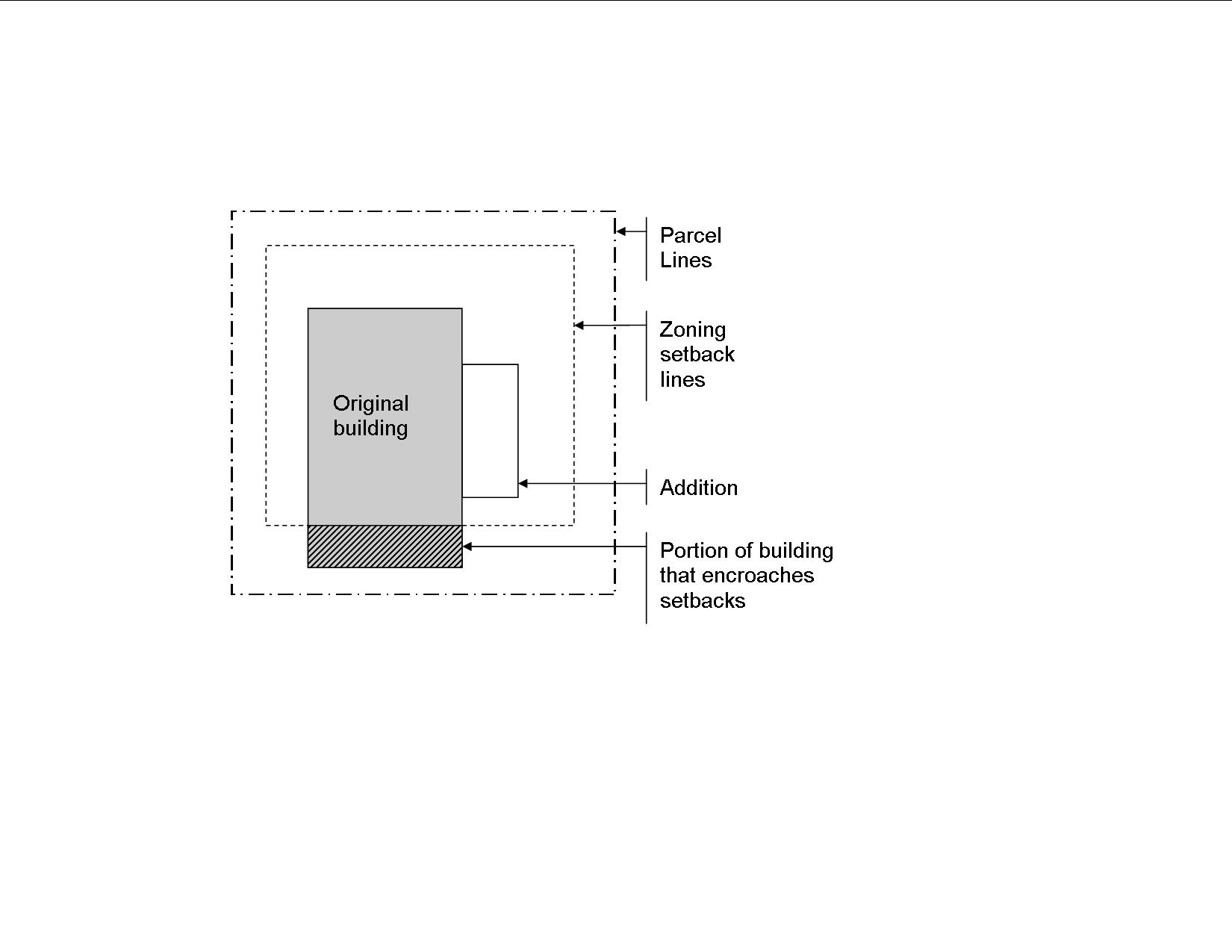
A nonconforming single-family or noncon-forming two-family structure may be extended or altered provided any such extension or alteration does not increase or intensify the nonconformity, e.g. an addition that does not encroach setbacks, provided building coverage or other nonconforming conditions are not exceeded.
A nonconforming single-family or noncom-forming two-family structure may be extended or altered such that the noncon-formity is increased or intensified, but no more than the e xisting nonconformity, upon issuance of a special permit by the Zoning Board of Appeals, provided the Board makes a finding that such extension or alteration is not substantially more detrimental to the neighborhood than the existing nonconforming structure, e.g. an addition that encroaches setbacks to the same or a lesser degree than the existing nonconformity, and further provided that with respect to the creation, alteration, or extension of an Accessory Dwelling Unit, the finding shall not require the issuance of a special permit.
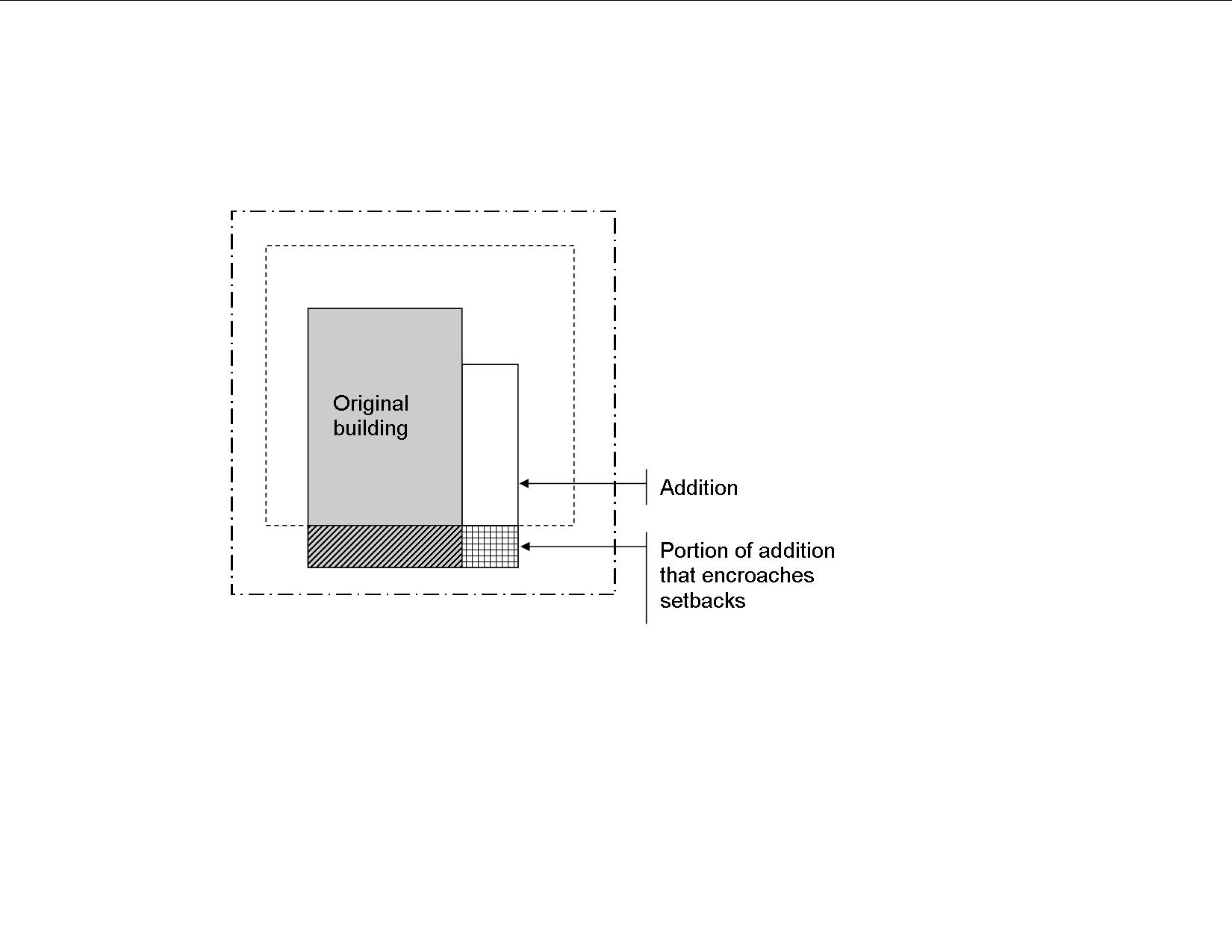
A nonconforming single-family or noncom-forming two-family structure may be extended or altered such that the noncomformity is increased or intensified to a greater degree than the existing nonconformity only upon issuance of a variance from the Zoning Board of Appeals, and provided the Board makes a finding that such extension or alteration is not substantially more detrimental to the neighborhood than the existing nonconforming structure, e.g. an addition that encroaches setbacks to a greater degree than the existing nonconformity.
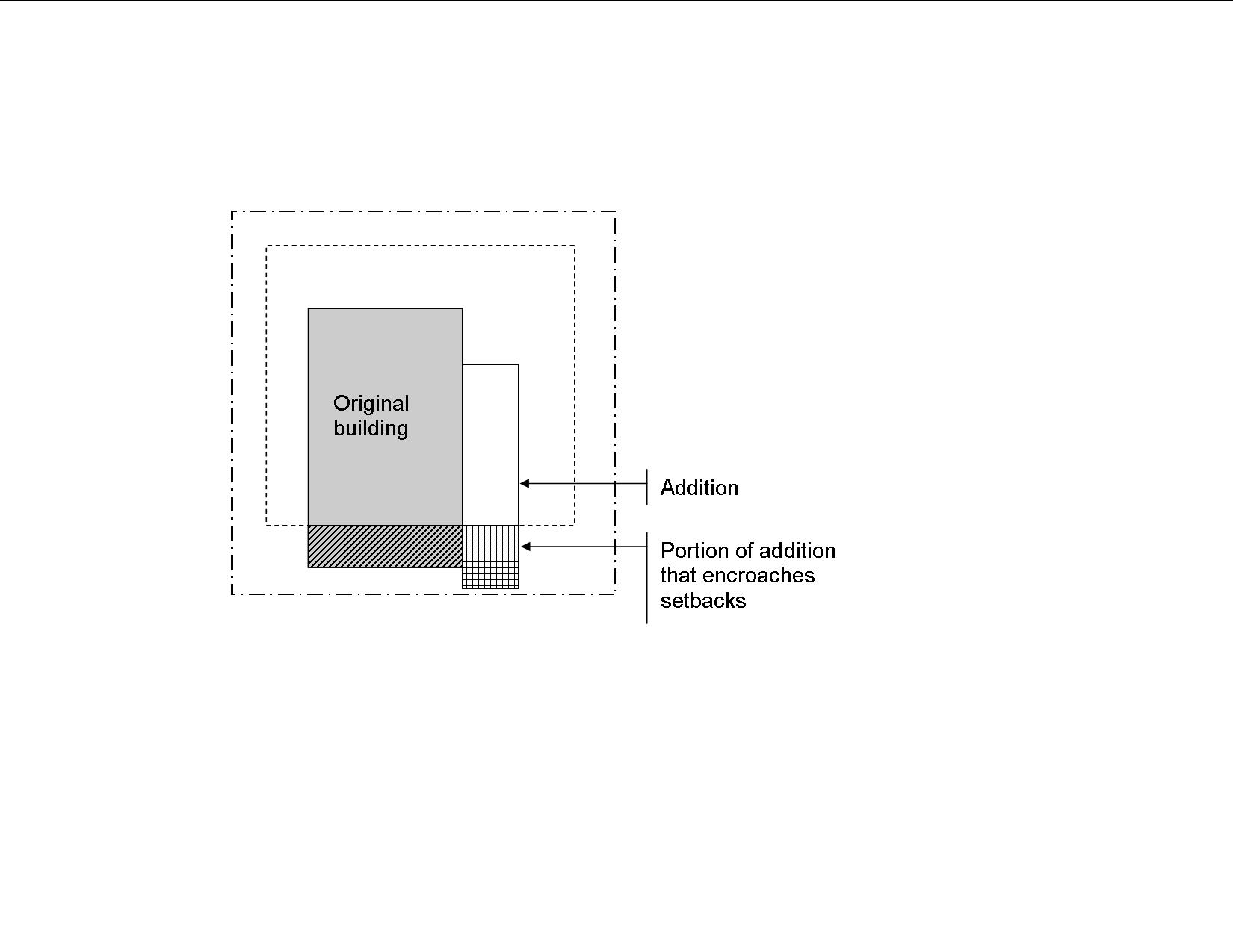
Multi-family residential and non-residential structures.
A nonconforming multi-family residential and/or non-residential structure may be extended or altered such that the nonconformity is not increased or intensified upon issuance of a special permit by the Zoning Board of Appeals, provided the Board makes a finding that such extension or alteration is not substantially more detrimental to the neighborhood than the existing nonconforming structure, e.g. an addition that does not encroach setbacks.
A nonconforming multi-family residential and/or non-residential structure may be extended or altered such that the nonconformity is increased or intensified upon issuance of a variance by the Zoning Board of Appeals, provided the Board makes a finding that such extension or alteration is not substantially more detrimental to the neighborhood than the existing nonconforming structure, e.g. an addition that encroaches setbacks to any degree, whether more or less than an existing encroachment.
Destruction of structures. Pre-existing non-conforming structures which are damaged or destroyed by accidental cause, including fire, or otherwise damaged or destroyed without the consent of the owner, may be repaired or reconstructed upon issuance of a building permit, provided that:
The non-conforming nature of the repaired or reconstructed structure is not increased in any respect;
A building permit for the repair or reconstruction shall be issued within two years from the date of the damage or destruction. Time incurred in resolving an appeal or other court action or insurance claim shall not be counted as part of the two year limit.
Any nonconforming use of a structure or land which has been discontinued for a period of two years or more, or which has been abandoned, shall not be re-established, and any future use of the structure or land shall comply with the provisions of this Bylaw.
If a nonconforming use of a structure or land is changed to a conforming use, it shall not thereafter revert to a nonconforming use.
Nonconforming uses may be extended or changed upon issuance of a special permit by the Zoning Board of Appeals provided the Board determines that such extension or change shall not be substantially more detrimental to the neighborhood than the existing nonconforming use. The Board of Appeals shall not allow an existing nonconforming use to be changed to a more intense nonconforming use than exists at the time of application, in terms of density or type of use.
Article 5Dimensional Regulations
§ 5.1Table of area requirements
Amended 1 November 2007
| Minimum | ||||||
|---|---|---|---|---|---|---|
| District | Lot Area (sq ft) | Lot Frontage (feet) | Lot Width (feet) | Setbacks Front | Setbacks Side & Rear | Buffer |
| RR Rural Residential | 60,000 | 200 | 100 | 55 | 25 | -- |
| SR Suburban Residential | 22,500 – 1 or 2 family 26,000 – 3 family 29,500 – 4 family 22,500/unit – 5+ family | 150 | 75 | 25 | 15 | -- |
| LR Lake Residential | 22,500 | 100 | 50 | 15 | 10 | -- |
| VR Village Residential | 10,000 – 1 or 2 family 12,500 – 3 family 15,000 – 4 family 8,000/unit – 5+ family | 80 | 40 | 20 | 10 | -- |
| TC Town Center Mixed Use | -- | -- | -- | -- | 10 | -- |
| C Commercial | 20,000 | 100 | -- | 30 | 20 | 60 |
| I Industrial | 40,000 | 150 | -- | 30 | 20 | 60 |
- OSRD projects are governed by Section 4.8.2 of this Zoning Bylaw, which supersedes this Table.
§ 5.2Interpretation notes for area
Amended 17 November 2016, 10 November 2022
The following shall be used to interpret the table of area requirements:
Lot area shall include all areas within a lot, including any area within said lot over which easements have been granted, provided that no area within a street (public or private) or under the surface of a lake or pond shall be included in determining minimum lot area.
Frontage is measured along the right-of-way line for the street between the points of intersection of the side lot lines with the street. For corner lots, at least 80% of the frontage requirement must be met on one street, and 100% of the requirement must be met on the two streets combined. However, when the two streets form an interior angle of more than 135 degrees, measured on extended lines of the rights-of-way, the entire frontage along the two streets combined shall meet the minimum frontage requirement.
The minimum lot width shall only apply to lots created after November 16, 2006. It shall be measured across the lot midway between the front and rear setback lines except for lots where, due to constraints of the shape of the parcel being subdivided, it is necessary to have two side lines converge at a point (triangular shape), in which case it shall be measured across the lot midway between the front setback line and the point of convergence of the two side setback lines. Lots configured with a narrow strip extending from the front of the lot back to a buildable area shall be reviewed on a case by case basis by the Planning Board, but in general are discouraged.
Setbacks are measured at right angles to the property line from that line to the nearest point of the structure. When the shape of the lot is so irregular as to make unclear the classification of side and rear lot lines, the Building Inspector/Zoning Enforcement Officer shall determine which setbacks apply.
Structures permitted within setbacks. The following structures are permitted within the setback areas required in Section 5.1:
fences below 6 feet in height;
uncovered steps, ramps or terraces;
covered or uncovered landings up to 40 square feet;
eaves and overhangs that do not project more than 2 feet from the exterior wall of the building;
bay windows that do not project more than 2 feet from the exterior wall of the building and which do not have a foundation;
chimneys that do not project more than 2 feet from the exterior wall of the building;
sign posts;
pedestrian lighting facilities with a height of less than 10 feet;
flagpoles;
other similar structures at the discretion of the Building Inspector/Zoning Enforcement Officer.
Detached Accessory Structures, including garages, sheds, swimming pools, etc. (see Section 4.4.1.A), on residential lots shall have a 10 foot setback from the side or rear lot line, provided said structure is located within the rear yard (i.e. anywhere behind the house from one side property line to the other). Any future connection of an accessory structure to a principal structure that creates nonconformity with regard to setbacks may be allowed by Special Permit issued by the Zoning Board of Appeals
Ground-Mounted Solar Photovoltaic Installations that are accessory to a principal use shall have a 10 foot setback from the side and rear lot line, and must be located within the rear yard (i.e. anywhere behind the house from one side property line to the other). Any proposed array that is determined to be nonconforming with regard to setbacks may be allowed by Special Permit issued by the Zoning Board of Appeals. The maximum height of the structures shall not exceed 10’ in residential districts or 15’ in non-residential districts.
The minimum buffer is required on all properties in the Commercial (C) or Industrial (I) districts which are adjacent to any other district, and shall be located along the property line adjacent to the other district. When the district line traverses a lot, the buffer may be located on either the C/I or the other district side of the district line. If the non-C/I portion of the lot is proposed to remain undeveloped, the owner is not required to install the buffer in that area, but the area must be designated for future buffer in the event development occurs in the future.
§ 5.3Specific provisions for area requirements
Amended 1 November 2007, 17 November 2016
All Special Permits required under this section shall be issued by the Zoning Board of Appeals except that the Planning Board shall issue them in cases where Site Plan Review and/or a Planning Board Special Permit in Section 4.2 Use Table, Principal Uses is required
Lots transected by a zoning district boundary. When a lot contains more than one zoning district, the area, frontage, width, and setback requirements of Section 5.1 shall be determined based on the district where at least 50% of the proposed structure will be located.
Amended 1 November 2007
Land conveyed for public purpose. Land conveyed to any public entity by any means, including eminent domain, donation, sale, or other method, shall not be subject to the dimensional requirements of this Zoning Bylaw, unless it is for the purpose of construction of one or more buildings. Furthermore, when such conveyance renders the remainder of the lot nonconforming with the dimensional requirements of this Zoning Bylaw, that lot shall be considered to be a buildable lot provided it has a minimum of 5,000 square feet and 50 feet of frontage, regardless of what zoning district it is within.
Single Family/Two Family residential restriction. Only one detached single family or two family dwelling shall be erected on a single lot. This shall not apply to residences constructed within and specifically for the operation of overnight camps, or to multi-family residential developments which include buildings of three or more dwelling units (and which may include two unit buildings as part of a mixture of building types).
Rural Residential District Exception. A parcel in the RR district that was legally in existence as of November 16, 2006 that contains more than 90,000 but less than 120,000 square feet and has a minimum of 400 feet of frontage, said parcel may be subdivided into no more than two lots, each with a minimum of 45,000 square feet and 200 feet of frontage. The provisions of Section 5.3.9 shall apply.
Residential setback exception. When a residential building (single family, two family, or multi-family) is erected on a street where the existing dwellings are within the required front setback area, the new residential building may be erected to the average front setback depth of the existing dwellings on either side, for a distance of three dwellings or to the end of the street, whichever is less. Any lots which are vacant are to be counted as if they comply with the required setback.
Side entry garages. When a garage is proposed which will require vehicular entry from the side (i.e. the garage door faces the side property line), the minimum distance from the garage door to the side property line shall be 25 feet measured perpendicular to the garage door to allow adequate room for vehicular movements without impacting the abutting property. This shall not be interpreted as an increase in the setback for the overall structure.
Double counting land area. When multiple uses and/or buildings occupy a single lot, no area of the lot may be counted towards the dimensional requirements for more than one use/building.
Minimum net useable area. All new lots created in the Town after November 16, 2006 shall contain a minimum net useable area, which shall be contiguous land, of:
15,000 square feet if the lot relies on an individual on-site sewage disposal system; or
5,000 square feet if the lot has access to the public sewer system.
This provision shall not apply to parcels created for recreation or open space purposes provided such lots have permanent restrictions indicating they are not buildable lots.
This provision shall not be interpreted as an increase in the minimum lot size or a decrease in the maximum number of dwellings which can be developed on a given tract of land.
Rear lot subdivision. Creation of parcels which do not meet the minimum frontage requirements set forth in Section 5.1 may be permitted upon the granting of a special permit pursuant to Section 7.2 provided the following criteria are met:
Frontage: The rear lot shall have at least 30 feet but no more than 40 feet frontage, and the front lot shall have a minimum frontage as required in Section 5.1.
Area: The front lot shall have a minimum area of two times that required in Section 5.1, and the rear lot shall have a minimum lot area of four times that required in Section 5.1.
Setbacks: The front lot shall have a minimum front setback of 75 feet, and the rear lot shall have minimum setbacks of twice that required in Section 5.1 (for all setbacks).
Access: The two lots created by the rear lot subdivision shall have access on a common driveway pursuant to Section 6.2, unless in the opinion of the Special Permit Granting Authority there are significant environmental or safety impediments to requiring the common driveway.
No rear lots are permitted within subdivisions where a new road was created (i.e. subdivision of land not eligible for the Approval Not Required [ANR] process).
The Special Permit Granting Authority may vary the requirements of paragraphs B, C, or D provided the proposal will not be detrimental to the public health, safety, or welfare, and that the particular physical conditions of the site warrant the variation. In addition, the SPGA may allow a boundary line adjustment to a parcel which existed as of November 16, 2006 and which has at least 200 feet of frontage, which is proposed to be subdivided into two lots (one front/rear pair) under these provisions, provided the adjustment is to add no more than 30 feet to the frontage of the parcel such that the resulting total frontage is no more than 230 feet.
All new lots (not the parent parcel) within a rear lot subdivision shall be restricted through a deed restriction stating no further subdivision of the lot is permitted, and that the lot may not be combined with any other parcels to increase the development potential on the adjacent parcel by more than one dwelling unit.
Parcels with insufficient frontage. In order to encourage preservation of open space, construction of one single family dwelling may be permitted on a single legal nonconforming parcel which does not meet the minimum frontage requirements set forth in Section 5.1, upon the granting of a special permit pursuant to Section 7.2, provided the following criteria are met:
The parcel was in existence as of November 16, 2006;
The parcel is a minimum of 7 acres in size; and
§ 5.4Table of Height and Bulk Requirements
| Zoning District | Maximum Height (feet) | Maximum Number of Stories | Maximum Building Coverage (%) | Maximum Impervious Surface Coverage (%) |
|---|---|---|---|---|
| RR | 35 | 2½ | 15 | 30 |
| SR | 35 | 2½ | 20 | 40 |
| LR | 35 | 2½ | 25 | 40 |
| VR | 40 | 3 | 25 | 50 |
| TC | 40 | 4 | 60 | 75 |
| C | 35 | 3 | 35 | 60 |
| I | 50 | 3 | 35 | 60 |
§ 5.5Interpretation notes for height and bulk
Amended 2 May 2024
The following shall be used to interpret the table of height and bulk requirements:
Exempted elements of a structure. The maximum height limitation shall not apply to chimneys, TV antennae, towers, ventilators, tanks, silos, roof-mounted solar photovoltaic generating installation, or other such elements, provided that such elements are constructed or erected so as to fall within the boundaries of the lot upon which the structure is located in the event of collapse. In no case shall any element of any structure exceed 51 feet in height from the average of the finished ground level adjoining the structure without a special permit from the Zoning Board of Appeals. The ZBA must make a finding that the requested increase will not be detrimental to the surrounding properties and it will be in harmony with the general purpose and intent of the Zoning Bylaw.
Maximum building coverage is the amount of the lot which can be occupied by buildings, including accessory buildings and structures.
Maximum impervious coverage shall apply to all non-residential development and multi-family residential development, and is the amount of the lot which can be covered with any impervious material, including buildings and other structures, paved parking areas, detention basins, ponds, and any other material which prevents water from infiltrating into the ground, but not sidewalks. In-ground infiltration systems may be used to meet this requirement at the discretion of the Building Inspector or, in the case of Planning Board or Zoning Board of Appeals action, by approval of said board.
Article 6Design Standards
§ 6.1Off Street Parking & Loading Requirements
Amended 1 November 2007, 17 November 2016
Number of Spaces
No land shall be used and no building or structure shall be erected, enlarged or used unless the off-street parking and loading space requirements as specified in Section 6.1.1 H are met.
Where the computation of required parking or loading spaces results in a fractional number, only the fraction of one-half (1/2) or more shall be counted as one (1).
Maximum number of spaces: The number of spaces provided on a lot may not exceed 5% of the required number for facilities over 50 spaces, or 10% of the required spaces for facilities of 50 spaces or less (as calculated by Section 6.1.1 H).
Overflow parking: For major retail uses such as shopping centers or other uses which may on occasion require additional parking to serve demand, an area not to exceed 25% of the required parking (as calculated by Section 6.1.1 H) may be used for overflow parking. This area shall be constructed with a pervious surface, preferably with a grass cover, and shall not be used for storage of any materials or products except snow. Overflow parking areas shall be designed to withstand the normal loads of passenger vehicles, with the exception that when a portion (a drive aisle) is to be used as emergency vehicle access (for secondary access to the site), that portion shall be designed to withstand the normal loads for emergency vehicles and equipment. Overflow parking areas shall not be lit during night time hours except when actually in use (such as during heavy volume shopping periods; e.g. between mid-November and the end of December).
Location of parking: A minimum of 50% of the required parking must be located on the same lot as the use which it serves, and any remaining required parking may be located on another lot provided the parking is within 800 feet of the use and a permanent parking easement is provided in favor of the use/building which requires said parking.
Where multiple uses exist on a single lot or within a single building, the parking requirement shall be computed for each use separately and added together. (For example, a motel with a restaurant would be required to provide parking for both the motel units and for seating capacity of the restaurant.)
Table of Parking Requirements
The permitting authority is the Building Inspector/Zoning Enforcement Officer for projects only requiring a building permit or a business certificate. All Special Permits required under this section shall be issued by the Zoning Board of Appeals except that the Planning Board shall issue them in cases where Site Plan Review and/or a Planning Board Special Permit in Section 4.2 Use Table, Principal Uses is required.
The number of parking spaces for uses in the TC district shall be required to the extent that it is physically possible to provide said parking on the site. The permitting authority shall determine the number of spaces required, taking into consideration issues such as rehabilitation of existing structures and availability of off-site public or private parking, including on-street parking.
Parking Facility Design
Perimeter buffer. All parking facilities shall conform to the following buffer requirements, except where the parking facility existed as of (date of passage) and a proposed use of the parcel and/or structure does not have a significant change in impact as determined by the Zoning Enforcement Officer, or, in the case of projects under site plan review, the Planning Board, and the buffer shall be planted with vegetation to screen the parked vehicles from the public streets:
In the VR district, 10’ front and 10’ side and rear (where abutting residential use).
In the TC district, 5’ front and none required on the side and rear.
In the C and I districts, 20’ front and 10’ side and rear (where abutting residential use).
Parking Space Size. Each required car space shall be not less than 9 feet in width and 18 feet in length exclusive of drives and maneuvering space and the total area of any parking facility for more than 5 cars shall average at least 300 square feet per car inclusive of driveways.
Handicapped Parking Spaces. Handicapped parking spaces shall conform to the standards of the Architectural Access Board of the Commonwealth of Massachusetts Department of Public Service.
Loading Space Size. Each loading bay shall be not less than 10 feet in width and 35 feet in length exclusive of drives and maneuvering space, and all required bays, drives and maneuvering space shall be located entirely on the lot with direct access to the building intended to be served.
Number of Loading Spaces. The number of loading spaces required shall be determined by the permitting authority based on the use and design of the building. In general, retail, wholesale, and industrial uses which are greater than 50,000 sq ft GFA should provide no fewer than 3 loading spaces.
Width of Drive Aisles.
24 feet for parking lots designed with 90 degree stalls (perpendicular parking); or
16 feet for parking lots designed with angled parking with 60 degree stalls; or
12 feet for parking lots designed with angled parking with 45 degree stalls.
For parking lots designed with angle parking differing from those stated above, the aisle width shall be the same as that for the next higher angle design.
Drive-up Facilities. In addition to the parking requirements above, any establishment installing a drive-up window must provide for the safe stacking of vehicles and an escape lane from the drive-up window on the site.
Establishments typically utilizing drive-up windows include, but are not limited to: coffee shop, fast food, bank (full service or ATM), pharmacy, and dry cleaner.
An escape lane is defined as a lane adjacent to a stacking lane which would allow a patron to exit from a stacking lane prior to reaching the service window/machine. Multiple stacking lanes shall be allowed to use a common escape lane.
Stacking and escape lanes shall be a minimum width of 10 feet except for curved sections which shall be a minimum of 12 feet.
All drive-up and escape lanes must be laid out in a way so as not to block or interfere with traffic circulation in the parking lot or interfere with parking spaces.
The required number of stacking spaces shall be determined by the permitting authority based on data submitted by the applicant, but in no case shall it be less than 5 spaces (20 linear feet shall equal one stacking space).
Where necessary due to site constraints, pedestrian ways across drive- up and escape lanes are permitted, provided appropriate signage and permanent pavement markings are installed to warn drivers of the presence of pedestrians and to give a safe path for pedestrians to walk.
Reduction by Special Permit. The requirements of Sections 6.1.1, 6.1.2, and 6.1.3 may be reduced upon issuance of a special permit (see Section 7.2.3.F).
| Use | Number Spaces Required |
|---|---|
| Dwelling (applies to all types of units: single, two-family, and multi-family) | 2 per unit for multi-family rental, parking may be reduced to 1.5 spaces per unit provided 50% of the units have 1,000 square feet or less of living space. |
| Lodging facilities | 1.2 per room |
| Nursing, convalescent, or assisted living facility | .33 per dwelling unit/room |
| Hospital, infirmary | 2 per bed |
| Day care – any age | 1 per 170 sq ft GFA may be reduced by permitting authority1 upon submittal of licensing material showing fewer spaces are needed based on maximum enrollment permitted by the licensing authority. |
| Places of Assembly | .5 per seat or per 30 sq ft GFA if no seating provided includes museums, clubs, theaters, bowling alleys, funeral establishments, and similar uses. |
| School: Elementary | 3 per classroom |
| School: Middle | 5 per classroom |
| School: High or College | 10 per classroom |
| School: Private trade or professional | .5 per seat |
| Office | 1 per 350 sq ft GFA |
| Retail Sales | 1 per 200 sq ft GFA |
| Retail Service | 1 per 225 sq ft GFA includes personal services, laundromats, dry cleaners, tailors, etc. |
| Shopping Center | 1 per 335 sq ft GFA includes all uses in center |
| Eating Establishments | 1 per 100 sq ft GFA + 1 per 100 sq ft gross area used for outdoor dining for drive-up, see Section 6.1.3 in addition to this requirement. |
| Automotive sales and services | 1 per 200 sq ft GFA used for offices (including sales desks) and waiting areas, + 1 per repair bay does not include area for storage and display of motor vehicles for sale. |
| Outdoor Recreation (golf course, tennis club, etc) | 1 per 3 golf holes or 3 courts |
| Marina | 1 per mooring |
| Laboratory or Research facility | 1 per 1,000 sq ft GFA |
| Industrial | 1 per 1,000 sq ft GFA may be modified by permitting authority1 if supporting documentation is submitted. |
| Warehouse | 1 per 2,500 sq ft GFA |
| Self Storage | 1 per 15,000 sq ft GFA including office and storage areas |
| Trucking, freight terminal, automotive processing facility | To be determined by the permitting authority based on the type of vehicle and the maximum capacity of the site. |
| All other uses | To be determined by the permitting authority based on a similar use in this table, or based on applicant submitted data. |
- 1. The permitting authority is the Building Inspector/Zoning Enforcement Officer for projects only requiring a building permit or a business certificate, or the Zoning Board of Appeals or Planning Board for projects requiring approval by either board. In the event a project requires approvals by both the Planning and Zoning boards, the Zoning Board shall make any determination on parking requirements.
§ 6.2Driveways/Curb-Cuts
Amended 7 May 2015, 5 May 2016
All driveways and curb-cuts shall comply with the requirements of the Spencer General Bylaws - Section 4. (Driveways, Curb Cuts and Drainage), and require a Driveway/Curb-Cut Permit issued by the Spencer Highway Superintendent or his/her designee. No Certificate of Occupancy shall be issued until the final approval of the driveway and driveway apron has been issued by the Highway Superintendent.
Applications for a Special Permit, Site Plan Review or Variance involving the construction or alteration of a driveway/curb cut must include a Driveway/Curb Cut Permit tentatively approved by the Highway Superintendent or his/her designee.
Applications for a Building Permit, Special Permit, Site Plan Review, Variance or any other town permit involving the construction or alteration of a driveway/curb cut must include a Driveway/Curb Cut Permit tentatively approved by the Highway Superintendent, or his/her designee.
For driveways/curb-cuts that involve a Special Permit, Site Plan Review or Variance the permit granting authority may permit:
a driveway closer than 10 feet to any side or rear lot line where they find that said driveway will still:
provide safe and reasonable access for emergency vehicles
be consistent with the purposes of this section
not have a detrimental impact on public safety.
more than one driveway/curb-cut per parcel in their approval of said permits where they find that:
the applicant can show that there is something unique about the property that would otherwise render flow to and from the property unsafe and unmanageable, and
more than one curb cut is necessary for traffic safety purposes, and
it is necessary to achieve, and does not conflict with, the Design Standards of this section.
it will be consistent with the purposes of this section
it will not have a detrimental impact on public safety.
Common Driveways
Purpose - Common driveways are not intended to circumvent the legal requirements for each lot having the required accessible minimum frontage. The purpose of allowing common driveways is to reduce traffic hazards and turning movements from numerous individual driveways and curb-cuts, to consolidate access to the buildable areas of lots across wetland resources, and to minimize the removal of trees and other vegetation, thereby preserving the rural character.
Abutting property owners are encouraged to coordinate access to their lots utilizing common curb-cuts and driveways under reciprocal easements. The Planning Board, in the approval of its Special Permit or Site Plan Review, may waive setback and related requirements to achieve this where they find that the applicant demonstrates that the curb-cut and access driveway design improves traffic circulation and reduces the number of turning movements onto the public way.
Authorization
For Commercial, Industrial, Institutional, Civic and Multi-Family Uses Common Driveways are permitted by-right subject to Site Plan Review issued by the Planning Board.
For single-family dwellings, common driveways are allowed by Special Permit issued by the Planning Board provided:
it may service up to four lots
Up to six lots may be permitted for common driveways that loop to the same road in two locations and are not dead-ends in any location.
Applications - Site Plan Review and Special Permit Applications for a common driveway shall include:
a site plan, developed by and carrying the seal of a certified professional engineer or a registered land surveyor, showing the layout for the common driveway, drainage, typical construction cross sections, profiles and meeting all of the design specifications required under this section.
easements, covenant and agreements, suitable for recording at the Registry of Deeds, for the subject lots containing restrictions including but not limited to:
prohibiting any additional vehicular access to said lots from other than the common driveway approved by this special permit.
stating that said common driveway is a private driveway and not a town way.
stating that if application is ever made for such common driveway to become a town way, such common driveway shall first, at the applicant's expense, be made to conform to the Rules and Regulations for the Subdivision of Land in the Town of Spencer in effect at the time that such application is made.
requiring that the maintenance, operation, repair and reconstruction (including snow plowing and snow/ice removal) is the responsibility and liability of the property owners.
an easement plan suitable for recording at the Registry of Deeds.
all deed easements, easement plans, restrictions, covenants and agreements must be submitted to and approved by the Planning Board prior to their recording and prior to the issuance of a common driveway special permit.
Design Standards – Proposed common access driveways shall also comply with all of the following:
All requirements of the Spencer General Bylaws - Section 4. Driveways, Curb Cuts and Drainage shall apply. The following standards in this section shall supersede those of the General Bylaw in cases where they conflict.
Shall be of suitable construction, grade, length and location, in the opinion of the Planning Board, for the access and turnaround of cars, trucks, ambulances, fire, and police which will be utilizing such driveway.
Each lot must have adequate approved legal frontage on an existing public way. Frontage requirements for each lot shall be along a town, county, state or approved subdivision road. Frontage along the length of private/common access driveways shall in no way be used to satisfy frontage requirements as specified in this section.
It shall access from the same public way that serves as the frontage for the lots being serviced by the common driveway, unless unique circumstances presented to the Planning Board are such that the Board may grant permission to access the common driveway from another public way.
It shall provide the only vehicular access to the lots being serviced by it, and shall be so stated in the lot deeds.
An easement with a minimum width of 24 feet shall be created and recorded along with the deeds for the lots to assure maintenance, drainage, snow removal, snow storage, rubbish collection, and the like, and liability for the common driveway shall remain the responsibility of the private parties, or their successors-in-interest, in perpetuity. A copy of the draft maintenance agreement shall be submitted with the application.
The minimum width for the durable surface shall be 12 feet and maximum width shall be 15 feet, with a 3 foot wide gravel shoulder on at least one side.
The minimum centerline radius shall be 45 feet.
The maximum length permitted shall be 2,000 feet.
Passing turnouts, providing a total width of at least 20 feet along a distance of at least 25 feet, spaced with no more than 300 feet between turnouts, and with the first such passing turnout at the driveway connection to the street, shall be provided.
A minimum side setback of 25 feet from any property not served by the proposed driveway.
No connection to any other way except the one from which it originates.
House numbers identifying all of the homes utilizing the common driveway shall be placed at its intersection with the town road and at each subsequent turnoff from the common driveway sufficient for identification by emergency vehicles.
Certification - Prior to the issuance of any occupancy permits for any of the lots serviced by such common driveway, the applicant shall submit to the Planning Board, as-built construction plans, prepared and stamped by a registered professional engineer and a certified statement from a registered professional engineer that such common driveway was constructed in accordance with the approved plans.
Waiver - Planning Board may grant waivers from the requirements of this section if they make a finding that doing so would not be inconsistent with the Purposes of this section nor have a detrimental impact on public safety.
§ 6.3Buffers
Purpose. The purpose of a buffer is to provide aesthetically acceptable visual and spatial separation between adjacent land uses, thereby enabling the juxtaposition of land uses of different types by minimizing negative impacts that a land use will impose on its neighbors. This section shall apply to any use which requires a buffer as provided elsewhere in this Zoning Bylaw.
Applicability to Exempt Uses. As provided in Article 4, Section 4.6 of this Zoning Bylaw, uses which are exempted under MGL Ch. 40A Section 3 are permitted in any zoning district provided they meet the minimum buffer requirements. Those minimum requirements shall be that such uses shall provide buffering of outdoor activity areas from adjacent residential uses utilizing landscaping, solid fencing, topography, and/or distance to reduce noise levels and other potential nuisances at nearby residential properties.
Design.
Plant Material. All buffers shall contain appropriate plant material to soften the visual impact of the structures or use from public view and from adjacent property. Existing trees and under story vegetation shall be retained wherever possible with additional plantings as necessary.
Structural Elements in Buffers. Structural elements, such as fences, walls, berms or other elements, may also be used depending on adjacent existing or zoned land uses. When fences or walls are used, adequate distance shall be maintained between the structure and the exterior property line for plant material to create a softening effect on the structure.
Avoid Monotonous Forms. To the extent practical, buffering materials shall be designed and maintained in a staggered or undulating manner to create a more natural looking buffer.
§ 6.4Lighting
Purpose. The purpose of this section is to provide standards for the lighting of commercial and industrial developments so as to reduce traffic safety hazards and protect property values and the aesthetic and historical appearance of the town through the reduction of light pollution and the preservation of the “night sky.”
Applicability. All commercial and industrial uses which are required to obtain site plan approval shall meet the following outdoor lighting standards:
The luminaries/lighting fixtures shall be the shoe box type or decorative in nature (with interior directional shields),with the architectural theme of the development. Flood and area lighting is unacceptable. All luminaries/lighting fixtures shall have a total cutoff of all light at less than ninety (90) degrees from vertical, except as provided below. The lighting source (lamp) shall only be visible from below.
The luminaries/lighting fixtures shall not exceed 35 feet in height, unless a greater height is shown by the applicant to result in a lesser impact on surrounding properties, roads, and sky glow. The luminaries/lighting fixtures for sidewalks or paths shall not exceed 12 feet in height.
Where wall-pack type luminaries/lighting fixtures are utilized, the fixture shall be equipped with a prismatic lens to reduce glare. Wall- pack lighting shall be designed to a maximum cutoff of seventy (70) degrees from vertical. The location of the wall-pack on the structure shall not exceed 20 feet in height.
All luminaries/lighting fixtures shall be restricted to a maximum footcandle level of 8.0 (initial), as measured directly below the fixture at grade.
All wiring for lighting fixtures shall be underground.
§ 6.5Signage
Amended 29 October 2009, 17 November 2016
(All Special Permits required under this section shall be issued by the Zoning Board of Appeals except that the Planning Board shall issue them in cases where Site Plan Review and/or a Planning Board Special Permit in Section 4.2 Use Table, Principal Uses is required).
Purpose
To provide minimum standards to safeguard life, health, property, and public welfare, and promote traffic safety by controlling the design, quality of materials, construction, illumination, size, location and maintenance of signs and sign structures;
To encourage signs that are of a quality design, pleasing in appearance, and are appropriate in size, materials, and illumination to the type of activity to which they pertain;
To ensure that commercial signs are designed for the purpose of identifying a business in an attractive and functional manner and serve as general advertising for the business;
To discourage signs which cause a traffic hazard or interfere with ingress/egress;
To implement the goals and policies of the Spencer Master Plan and bylaws by enforcement of the regulations contained within this section.
Applicability. A sign or advertising device of any kind may be erected on any premises or affixed to the outside of any structure or be visible from the outside of any structure in Spencer only as specified in this section. Permanent signs require a permit from the Inspector of Buildings. Temporary signs on business property or pertaining to a business or non-profit organization are permitted subject to the provisions in Section 6.5.3.A.2.
Regulations
All Districts. The following provisions apply to signs regardless of the district in which it is located.
Provisions applicable to all temporary signs:
Temporary signs shall not be displayed in any manner outdoors or on the exterior of any building for a period of more than 60 days, and shall be removed not later than 7 days from the conclusion of the promoted event. Real estate and political signs are exempt from this provision. Temporary signs which are located on the interior of a window are not regulated.
Temporary signs must be maintained in good condition.
Temporary signs of any type must maintain a setback that provides a clear line of sight on roads and prevents traffic hazards.
Temporary signs shall not be illuminated.
Provisions applicable to for-profit businesses and organizations:
One temporary sign per business is allowed provided that a notification has been sent to the Inspector of Buildings by the individual displaying the sign stating the beginning and end dates that the temporary sign will be displayed. Real estate and political signs are exempt from this provision.
Notification to the Inspector of Buildings for temporary signs may cover a period of time not to exceed one year. Within this one year notification cycle, temporary signs are required to change message at least once every 60 days.
The size of temporary signs shall not exceed the following (signboard area): In the C and I districts, 100 sf; in the TC district, 50 sf; in the VR district along Main Street, 12 sf; and elsewhere in the VR district and in the LR, SR, and RR districts, 3 sf.
Banners, flags, streamers or other decorations that do not convey commercial information shall not be considered temporary signs and are exempt from the provisions of this bylaw.
Temporary signs that are also off-premise signs will be regulated as off-premise signs.
Provisions applicable to not-for-profit organizations:
Temporary signs, either on or off-premises, for events that have been duly approved by the appropriate authority (if any) are permitted provided that a notification has been sent to the Inspector of Buildings by the organization displaying the sign(s) stating the beginning and end dates that the temporary sign(s) will be displayed, the location of the sign(s), and if on public property, a letter from the appropriate authority stating permission has been granted to place the sign(s) in said locations.
The size of off-premises temporary signs shall not exceed 10 sf signboard area, except for the following: in the VR district along Main Street, 12 sf; TC, 50 sf, and C and I, 100 sf.
Off-premise Signs. In any district, the Zoning Board of Appeals may allow by special permit off-premise sign(s) for a business provided that the sign(s) complies with the following conditions:
The sign shall contain the business name and directional information only.
The sign shall only be used to advertise commercial establishments located within Spencer, Massachusetts.
An off-premise sign shall not exceed 3 sf signboard area if located in the LR, SR, VR, or RR district except as provided below; or 12 sf signboard area if located in the VR district on a property along Main Street; or 30 sf signboard area if located in the Residential Business Overlay district within the RR district; or 30 sf signboard area if located within the TC, C, or I districts; nor can it extend more than 15’ above ground if free-standing.
An off-premise sign that is attached to a non-residential structure as a wall sign in a residential zone may not exceed 8 sf total signboard area.
An off-premise sign for an Agricultural Use as referenced in Section 3 of MGL Ch. 40A, located in a residential zone may not exceed 12 sf signboard area.
Every off-premise sign shall be maintained in good structural and aesthetic condition at all times. Any abandoned or deteriorated sign shall be removed or renovated within 60 days of written notice, or shall be subject to removal and disposal by the Town pursuant to court authorization. Any unsafe sign shall be removed immediately upon written notice, or shall be subject to removal by the Town to preserve public safety.
Off-premise signs shall not be illuminated.
Sandwich board signs are allowed only in the Village Residential, Town Center, Commercial and Industrial districts and the Residential Business Overlay district, and then only with approval from the Spencer Sign Advisory Committee. Sandwich boards require a sign permit from the Inspector of Buildings.
The maximum area shall be 12 sf signboard area and the maximum height shall be no more than 4’.
Only 1 sandwich board sign per business shall be permitted for businesses with 50’ or less of frontage. For businesses with more than 50’ of frontage, up to 2 sandwich board signs are allowed.
Sandwich boards shall not be placed so as to cause the width of the sidewalk to be less than is required under American Disability Act (ADA) guidelines.
Sandwich board signs shall not be placed more than 6’ from the primary entrance of the business that they are advertising and shall not impede the flow of traffic to adjacent businesses.
Sandwich board signs shall not be illuminated.
Sandwich board signs may only be displayed during normal hours of business operation and must be taken inside at the close of each business day for storage.
Sandwich board signs are required to change message at least once every 60 days.
A sign shall not be considered abandoned if it has received a determination from the Board of Selectmen classifying it as a Landmark Sign. Landmark signs must be preserved and maintained in sound structural condition.
A permitted landmark sign shall not count towards the total allowed signboard area square footage for any given use.
Private Property Signs
Signs used to post property for such purposes as placing notice of “notrespassing”, “no hunting”, “do not feed the animals” or similar notices shall not be regulated under this Section 6.5 provided said signs are no more than 2 sf in signboard area.
Maintenance of Signs
All signs shall be maintained to be in sound structural condition and the face shall be maintained to be readable. Signs for businesses which are no longer in operation for a period of more than 30 days shall be considered abandoned signs and shall be removed or modified to eliminate the sign copy pertaining to the business within 30 days of being abandoned or 60 days from the closing of the business.
Any sign determined to be abandoned shall be subject to removal and disposal by the Town, pursuant to court authorization. Prior to removal, the Town shall send a written notice by certified mail, return receipt requested, to the last known address of the business owner, with a copy to the property owner, notifying that if the sign is not removed within 65 days of the date of mailing (postmark) of the notice, the owner of the sign shall have relinquished his rights to the sign and the Town may remove and dispose of the sign after the 65th day.
Prohibited Signs
Any sign larger than 200 sf signboard area if freestanding or 150 sf signboard area if wall mounted.
Signs placed on unregistered, inoperable vehicles or trailers which are parked on one property for more than 30 consecutive days for the purpose of displaying a sign. This prohibition does not apply to registered vehicles used in the regular course of business with a primary purpose other than advertising.
Any new sign not erected pursuant to and in accordance with the requirements of this Section 6.5.
Residential Districts (RR, SR, LR). Signs or advertising devices are permitted as follows:
One sign displaying the street number or name of the occupant of premises, or both, not exceeding 3 sf in signboard area. Such sign may be attached to a building or may be freestanding. Such sign may include identification of a permitted or approved accessory use, e.g. uses permitted under Section 4.8.3, Use of Residence for Business Purposes.
One bulletin or announcement board or identification sign for a permitted non-residential building or use is allowed provided that it is not more than 6 sf in signboard area.
For churches and institutions, 2 bulletin or announcement boards or identification signs are permitted for each building. Each such church or institution sign shall be not more than 10 sf in signboard area.
A lawfully non-conforming use is allowed one sign not more than 6 sf in signboard area.
In the Residential Business Overlay District within the Rural Residential District, one freestanding sign per business is allowed with not more than 50 sf in signboard area, and one wall mounted sign is allowed not to exceed 50 sf in signboard area.
Freestanding signs shall be located a minimum of 5’ from the public right-of-way, and shall not exceed 6’ in height, measured from the average grade under the sign.
No permanent sign shall contain any moving parts. No sign shall be of gaseous tube or illuminated tube type.
Illumination shall be by an externally located steady stationary light source, shielded and directed solely at the sign.
For properties located on Main Street, such sign shall not exceed 12 sf in signboard area.
For properties located on any other street, such sign shall not exceed 3 sf in signboard area.
For churches and institutions located anywhere in the VR district, 2 bulletin or announcement boards or identification signs are permitted for each building. Each such church or institution sign shall not be more than 10 sf in signboard area.
A lawfully non-conforming use located anywhere in the VR district is allowed 1 sign not more than 6 sf in signboard area.
Freestanding signs on properties located on Main Street shall be located a minimum of 2’ from the public right-of-way, and shall not exceed 8’ in height, measured from the average grade under the sign.
Freestanding signs on properties located on any street except Main Street shall be located a minimum of 5’ from the public right-of-way, and shall not exceed 6’in height, measured from the average grade under the sign.
Illumination shall be by an externally located steady stationary light source, shielded and directed solely at the sign.
One gaseous tube or illuminated tube type sign is allowed. Such sign shall be a window sign attached from the interior of the permitted use and shall not exceed 4 sf in signboard area.
Town Center
The maximum overall size of a permitted wall sign may not exceed 2 sf of signboard area per lineal foot of building facade associated with that use facing on a street or public pedestrian way, or on a parking lot which is located within the property lines of this use or 100 sf, whichever is less.
Wall signs may not project vertically past the roof line.
Wall signs may not project horizontally further than the extent of the wall to which they are attached.
For those buildings higher than 1 story with additional businesses located on the upper floors, an additional wall sign may be allowed for each façade facing a street, public pedestrian way, or parking lot that indicates the businesses occupying that building. These signs may not exceed 3 sf in signboard area.
In addition to wall signs, one double-face projecting sign per business on the first floor is permitted. Such a sign shall be no larger than 12 sf in signboard area, may project no closer than 3’ to the street curb, and must provide at least 7’ of clearance from the bottom of the sign to the sidewalk directly below.
Where buildings are set back 10’ or more from the street right-of- way, 1 freestanding sign per lot is permitted. For businesses with 50’ or less of street frontage, such freestanding sign shall not exceed 50 sf in signboard area and shall not obstruct views to signs advertising directly adjacent businesses. For businesses with more than 50’ of street frontage, such freestanding sign shall not exceed 100 sf in signboard area.
Freestanding signs must be located 3’ from the pedestrian way.
Internally illuminated signs are allowed.
Signs which have blinking, flashing or fluttering lights or other illuminating devices which have a changing light intensity, brightness or color, are prohibited. This includes electronic message centers.
Electronic signs that display only time and temperature are allowed by special permit of the Zoning Board of Appeals.
Roof mounted, single sided signs are allowed by special permit of the Zoning Board of Appeals and shall be counted toward the total allowed signboard area for a use and not as additional allowed signboard area.
Gaseous tube or illuminated tube type signs are allowed.
Illumination shall be by an externally located steady stationary light source, shielded and directed solely at the sign, except for internally illuminated signs.
Commercial and Industrial Districts
The maximum overall size of a permitted wall or single sided roof mounted sign may not exceed 2 sf of signboard area per lineal foot of building facade associated with that use facing on a street or public pedestrian way, or on a parking lot which is located within the property lines of this use or 150 sf, whichever is less.
One double faced projecting sign not exceed 48 sf in signboard area is allowed.
One double faced freestanding sign per lot is permitted.
For a single use building 100,000 sf in size or less, 1 double faced freestanding sign is allowed not to exceed 100 sf in signboard area.
For a single use building larger than 100,000 sf in size or more, 1 double faced freestanding sign is allowed not to exceed 150 sf in signboard area.
For multi-tenant buildings that are 100,000 sf in size or less or that have less than 300’ of street frontage, 1 double faced freestanding multiple tenant sign is allowed not to exceed 150 sf in signboard area.
Amended 29 October 2009
For multi-tenant buildings that are over 100,000 sf in size or that have 300’ or more of street frontage, 1 double faced freestanding multiple tenant sign is allowed not to exceed 200 sf in signboard area.
The top edge of any such free standing sign shall not be higher than 25’ measured at the average level of the ground between the supports of the sign.
Any free-standing sign may be located within the required building front setback, but not nearer than 8’ to any lot line.
Internally illuminated signs, including gaseous tube signs, are permitted, providing the illumination is steady and stationary (not flashing or moving in any manner).
Illumination shall be by an externally located steady stationary light source, shielded and directed solely at the sign, except for internally illuminated signs.
Signs which have blinking, flashing or fluttering lights or other illuminating devices which have a changing light intensity, brightness or color, are allowed by Special Permit of the Zoning Board of Appeals. This does not include electronic message centers.
Electric animated signs such as electronic message centers are allowed including LCD and LED signs provided that they are no more than 100 sf in signboard area. The message display time shall remain static for a minimum of 8 seconds with a maximum instant message change time of 1 second. Video, continuously scrolling messages and animation are allowed only by Special Permit.
A maximum of 3 directional signs which direct customers to specific areas of a site are permitted without Special Permit; any request for more than 3 directional signs requires a Special Permit from the Zoning Board of Appeals. Such directional signs may not exceed 2 sf in signboard area. When mounted as a freestanding sign, such signs may not exceed 3’ in height.
Non-conforming Signs:
A sign that was legally erected before October 16, 2008 which does not conform to the provisions of this bylaw may continue to be maintained until such time it is abandoned, enlarged, relocated, or reworded to reflect a change in business name. When the sign is subject to any of these triggering events, a new sign must be installed that conforms to the provisions of this bylaw. Any sign which has deteriorated to such an extent that the cost of the restoration would exceed 50% of the replacement cost of the sign at the time of restoration shall not be repaired, rebuilt, or altered except to conform to the requirements of this Section 6.5.
Administration
Sign Advisory Committee.
Establishment. There is hereby established a Sign Advisory Committee which shall be a three member body appointed by the Town Administrator with three year terms (with the initial terms set at 1 year, 2 years, and 3 years to establish an offset term expiration of members). Membership shall consist of one Spencer merchant, one Spencer non-residential property owner, and one Spencer residential property owner. (The merchant and non- residential property owner are not required to be residents of Spencer, although residents should be given priority.)
Powers.
The Sign Advisory Committee shall review and provide a written report with their recommendations to the Inspector of Buildings for all permit applications for permanent signs in the Town Center District. While this review process takes place after the application is filed with ODIS, the business owner has the option of seeking the advice of the Committee prior to submitting the sign permit application to ODIS. The Committee’s report is advisory in nature and the Inspector of Buildings may issue permits without requiring modifications, if any, recommended by the Sign Advisory Committee.
The Sign Advisory Committee shall review all permit applications for temporary sandwich board signs and shall submit a written report to the Inspector of Buildings prior to the issuance of the sign permit. For sandwich board signs located within the TC district, the Inspector of Buildings shall not issue a permit unless recommended by the Sign Advisory Committee, and further shall require modifications, if any, to the sign as recommended by the Committee. In the C and I districts, the Inspector of Buildings may issue a permit without regard to the Committee’s recommendations.
The Sign Advisory Committee shall review all applications for Special Permit under Section 6.5.5.B and shall submit a written report with their recommendations to the Special Permit Granting Authority prior to or at the public hearing of the SPGA.
The Sign Advisory Committee shall follow all the laws pertaining to the Open Meeting Law, and further shall establish their own rules of procedure in regard to the time and date of their meetings. Based on the responsibilities of the Committee, meetings at the call of the Chair may be in the best interest of the community, to be as open and responsive to the needs of the business community as possible. Since no actions of the Sign Advisory Committee are the final action (i.e. a permit must be issued by the Inspector of Buildings and in some cases the Zoning Board of Appeals), public hearings are not required; however all meetings must be posted in compliance with the Open Meeting Law.
Relief from these regulations. Relief from the restrictions in Section 6.5.3 may be granted by Special Permit, provided the Sign Advisory Committee submits their written report prior to or at the public hearing on the application. Failure of the Committee to submit a written report shall constitute a recommendation for approval with no modifications to the proposed sign by the Committee.
Article 7Administration
§ 7.1Zoning Board of Appeals
Amended 1 November 2007, 17 November 2016
Establishment. There shall be a Board of Appeals of three (3) members appointed by the Selectmen. The Selectmen shall also appoint two (2) associate members to the Board of Appeals. The appointment, service and removal or replacement of members and associate members and other actions of the Board of Appeals shall be as provided in Chapter 40A of the Massachusetts General Laws.
Powers. The Board of Appeals shall have the following powers:
Appeals – to hear and decide appeals taken by any person aggrieved by reason of their inability to obtain a permit or enforcement action from any administrative officer under the provisions of MGL Chapter 40A, or by the regional planning agency, or by any person, including an officer or board of the Town of Spencer or of an abutting Town aggrieved by an order or decision of the Inspector of Buildings or other administrative official, in violation of any provision of said Chapter 40A or the Zoning Bylaw of the Town of Spencer. Any such appeal shall be taken within thirty (30) days from the date of the order or decision which is being appealed, by filing a notice of appeal with the Town Clerk in accordance with the provisions of Chapter 40A.
Special Permits – To hear and decide applications for special permits as provided in this By-Law, subject to any general or specific rules therein contained and subject to any appropriate conditions and safeguards imposed by the Board of Appeals. See Section 7.2.
Variances – To authorize upon application a variation from the terms of this Zoning Bylaw except that no variation to the district boundaries or uses permitted therein shall be allowed. See Section 7.3.
§ 7.2Special Permits
Amended 7 May 2015, 17 November 2016
Special Permit Granting Authority (Reserved for future use)
Planning Board. The Planning Board shall be the Special Permit Granting Authority for the following:
Two-family dwellings (Section 4.3.1);
Amended 1 November 2007
Multi-family development (Section 4.3.2);
Wind Energy Conversion Facilities (Section 4.8.7)
Rear lot subdivision (Section 5.3.10);
Common driveway (Section 6.2) and
Signage, but only when an applicant is required to comply with Section 7.4, Site Plan Review.
Amended 16 October 2008
Zoning Board of Appeals. The Zoning Board of Appeals shall be the Special Permit Granting Authority for all other uses or proposals which require a Special Permit.
Amended 17 November 2016
Review Procedure
Public Hearing and Decision.
The Special Permit Granting Authority shall hold a public hearing no later than 65 days after the filing of an application. Notice of the public hearing shall be as prescribed by MGL Ch. 40A Sec. 11. The Special Permit Granting Authority shall have the power to continue a public hearing under this section if it finds that such continuance is necessary to allow the petitioner or applicant to provide information of an unusual nature and which is not otherwise required as part of the special permit application.
The Special Permit Granting Authority shall issue a decision no later than 90 days following the close of the hearing. Failure by a Special permit Granting Authority to take final action upon an application for a special permit said 90 days following the close of the public hearing shall be deemed to be a grant of the permit applied for.
Voting requirements: For a special permit to be granted, at least 4 of the 5 members of the Planning Board, or all 3 of the members of the Zoning Board of Appeals, must vote to grant the special permit.
Reports from Town Boards or Departments. The Special Permit Granting Authority shall transmit forthwith a copy of the application and plan(s) to other boards, departments, or committees as it deems necessary or appropriate for their written reports. Any such entity to which applications are referred for review shall make such recommendation or submit such reports as they deem appropriate and shall send a copy thereof to the Special Permit Granting Authority and to the applicant. Failure of any such entity to make a recommendation or submit a report within 35 days of receipt of the application shall be deemed a lack of opposition.
Effective Date of Special Permit. No special permit or any modification, extension or renewal thereof shall take effect until a copy of the decision has been recorded in the Worcester County Registry of Deeds. Such decision shall bear the certification of the Town Clerk that 20 days has elapsed after the decision has been filed in the office of the Town Clerk and no appeal has been filed, or it has been dismissed or denied.
Time Limitation on Special Permit. A special permit shall lapse if a substantial use thereof has not been commenced except for good cause or, in the case of a permit for construction, if construction has not commenced except for good cause within two years from the granting of the special permit or other period of time as specified by the Special Permit Granting Authority, not to exceed two years from the date of grant thereof.
Findings
The Special Permit Granting Authority may grant special permits for certain uses or structures as specified in the Use Table (Section 4.2) and elsewhere in this Bylaw. Before granting a special permit, the Special Permit Granting Authority, with due regard to the nature and condition of all adjacent structures and uses, shall find all of the following conditions to be fulfilled:
The use is in harmony with the general purpose and intent of this Bylaw and any applicable subsections herein.
The proposed use will not create undue traffic congestion nor unduly impair pedestrian safety.
The proposed use will not impair the integrity or character of the district or adjoining zones nor will it be detrimental to the health, safety or welfare of the neighborhood or the Town.
For Multi-Family or Attached Single-family Residential Development, the following findings must also be made:
The proposed project includes buffers along all property lines of a minimum of 40 feet and are designed to minimize impacts to abutters;
The proposed project is not out of character with the area in which it is located;
The parking facilities are located away from the areas along the public street(s), or are integral to the buildings (i.e. garages); and
The proposed project does not increase the Average Daily Traffic (ADT) of roads within the general area by more than 10 percent in any given year, nor reduce the Level of Service at intersections within the same area to less than a “C” standard as determined by a professional traffic engineer.
For Shopping Centers, the following findings must also be made:
The proposed project minimizes environmental impacts including erosion, siltation, changes to ground and/or surface water levels (quantity), or changes to ground or surface water quality;
The access roads, utilities and site drainage are designed in accordance with the Planning Board’s rules and regulations governing subdivision; and
The proposed project does not increase the Average Daily Traffic (ADT) of roads within 1000 feet of the site by more than 50 percent nor reduce the Level of Service at intersections within the same area to less than a “C” standard as determined by a professional traffic engineer.
The Special Permit Granting Authority may grant special permits to allow relief from the provisions of Section 6.1.1, 6.1.2, and/or 6.1.3 (Parking) only if the following findings are made:
the proposed relief is in the best interest of the municipality and will not be detrimental to surrounding uses or the neighborhood, particularly by shifting parking demand to adjacent properties or using a disproportionate number of on-street or public parking spaces; and
that the proposed relief will not create a nuisance, hazard, or congestion to vehicular or pedestrian traffic.
The Special Permit Granting Authority may grant special permits to allow relief from the provisions of Section 6.5.3 (Signage) only if the following findings are made:
that the requested relief will not be contrary to the purpose of Section 6.5;
that the proposed sign or advertising device will not create a nuisance, hazard, or congestion to vehicular or pedestrian traffic; and
that the size, location, design, color, texture, lighting, and materials of the proposed sign or advertising device will complement the architectural and natural setting of the premises.
Conditions. The Special Permit Granting Authority may impose in addition to any other condition specified in this Bylaw such additional conditions as it finds reasonably appropriate to minimize impacts on abutters, safeguard the neighborhood, or otherwise serve the purposes of this Bylaw. Such conditions may include but are not limited to the following:
Dimensional requirements greater than the minimum required by this Bylaw.
Screening of parking areas or other parts of the premises from adjoining premises or from the street by specified walls, fences, plantings or other devices.
Modification of the exterior features or appearance of the structure.
Limitation of size, number of occupants, method and time of operation, and extent of facilities, or duration of the permit.
Regulation of number, design and location of access drives, drive-up windows and other traffic features.
Regulation of off-street parking or loading beyond the standards required by this Bylaw.
Requirements for performance bonds or other security.
Installation and certification of mechanical or other devices to limit present or potential hazard to human health, safety, or welfare of the Town or of the environment resulting from smoke, odor, particulate matter, toxic matter, fire or explosive hazard, glare, noise, vibration or any other objectionable impact generated by any given use of land.
§ 7.3Variances
Review Procedure
Public Hearing and Decision. The Zoning Board of Appeals shall hold a public hearing no later than 65 days after the filing of an application. Notice of the public hearing shall be as prescribed by MGL Ch. 40A Sec. 11. The Zoning Board of Appeals shall have the power to continue a public hearing under this section if it finds that such continuance is necessary to allow the petitioner or applicant to provide information of an unusual nature and which is not otherwise required as part of the variance application. For a variance to be granted, all 3 of the members of the Zoning Board of Appeals must vote to grant the variance.
Reports from Town Boards or Departments. The Zoning Board of Appeals shall transmit forthwith a copy of the application and plan(s) to other boards, departments, or committees as it deems necessary or appropriate for their written comments. Any such entity to which applications are referred for review shall make such recommendation or submit such comments as they deem appropriate and shall send a copy thereof to the Zoning Board of Appeals and to the applicant. Failure of any such entity to make a recommendation or submit a report within 35 days of receipt of the application shall be deemed a lack of comment.
Effective Date of Variance. No variance or any modification, extension or renewal thereof shall take effect until a copy of the decision has been recorded in the Worcester District Registry of Deeds. Such decision shall bear the certification of the Town Clerk that 20 days has elapsed after the decision has been filed in the office of the Town Clerk and no appeal has been filed, or it has been dismissed or denied.
Time Limitation on Variance. A variance shall lapse if a substantial use thereof has not been commenced except for good cause or, in the case of a permit for construction, if construction has not commenced except for good cause within one year from the granting of the variance or other period of time as specified by the Zoning Board of Appeals, not to exceed one year from the date of grant thereof. An extension not to exceed six months may be granted by the Zoning Board of Appeals provided a request is filed for the extension prior to the expiration of the one year period.
Mandatory Findings. Before the granting of any variance from the terms of this bylaw, the Board of Appeals must specifically find that:
Owing to circumstances relating to the soil conditions, shape or topography of land or structures, and especially affecting such land or structures but not affecting generally the zoning district in which it is located, a literal enforcement of the provisions of this by-law would involve substantial hardship, financial or otherwise to the petitioner or appellant; and
that desirable relief may be granted without substantial detriment to the public good and without nullifying or substantially derogating from the intent or purpose of this by-law.
Conditions. The Zoning Board of Appeals may, in order to minimize impacts on abutters or the neighborhood caused by the granting of a variance, impose such conditions, safeguards and limitations as it deems appropriate to protect the abutters or the neighborhood.
§ 7.4Site Plan Review
Amended 29 October 2009, 17 November 2016
Purpose. The purpose of this section is to protect the health, safety, convenience and general welfare of the inhabitants of the Town by providing for a review of plans for uses and structures which do not require definitive subdivision review and may have significant impacts, both within the site and in relation to adjacent properties and streets, on pedestrian and vehicular traffic; public services and infrastructure; environmental, unique and historic resources; abutting properties; and community needs.
Applicability. The following activities for all uses except residential dwellings of three or fewer units or for any exempt use under MGL Ch. 40A Sec.3 require site plan review by the Planning Board:
Construction of new structures except for accessory structures that have a footprint of 1,000 square feet or less;
Exterior alteration or expansion which increases the footprint size of the structure by 500 square feet or more requires minor site plan review (see Section 7.4.6);
Exterior alteration or expansion which increases the footprint size of the structure by 2,000 square feet or more requires major site plan review;
Change of use from one use category to another (e.g. residential to commercial), where in the opinion of the Planning Board the change will alter the use of the site to the extent that site plan review is necessary to further the purposes set forth in Section 7.4.1; or
Construction or expansion of a parking lot with 10 spaces or more.
Procedure. Site Plan Review shall be administered by the Planning Board except, in cases where the project also requires a Special Permit, said Site Plan Approval shall be issued by the same Special Permit Granting Authority and shall be included as part of that Special Permit Application. In such cases the Site Plan Approval and Special Permit reviews and procedures shall be consolidated into a single process and any approval, findings and conditions for said Site Plan Approval shall be in addition to and incorporated as a part of the findings and conditions of the Special Permit.
Applicants for site plan review shall submit seven (7) copies of the site plan to the Planning Board through the Office of Development & Inspectional Services (ODIS) for review.
The ODIS shall forward a copy of the site plan to the Superintendent of Utilities & Facilities, the Sewer Department (if applicable), the Fire Chief, and the Disabilities Commission for their advisory review and comments, which shall be submitted to ODIS within 30 days of receipt. Failure to report within this time frame shall be interpreted to mean there are no objections or comments on the site plan as submitted.
The Planning Board shall hold a public hearing and review and act upon the site plan, with such conditions as may be deemed appropriate, within sixty (60) days of its submission unless the Board and applicant have agreed to a time extension, and shall notify the applicant in writing of its decision. Notice of the public hearing shall be as prescribed by MGL Ch. 41 Sec. 81T. The decision of the Planning Board shall be upon a majority of the Board as constituted (i.e. 3 out of 5) and shall be in writing.
No building permit or certificate of occupancy shall be issued by the Building Inspector without the written approval of the site plan by the Planning Board, or unless 60 days lapse from the date of the submittal of the site plan without action by the Planning Board, unless the Board and applicant have agreed to a time extension.
(reserved for future use)
(reserved for future use)
The applicant may request, and the Planning Board may grant by majority vote, an extension of the time limits set forth herein.
No deviation from an approved site plan shall be permitted without approval by the permitting authority.
Preparation of Plan
Applicants are invited to submit a pre-application sketch of the proposed project to the Planning Board and to schedule a conceptual discussion with the Planning Board at a regularly scheduled meeting.
Site Plans shall be submitted on 24 inch by 36 inch sheets and shall be prepared by a Registered Professional Engineer, Registered Land Surveyor, Architect, or Landscape Architect, as appropriate. Dimensions and scales shall be adequate to determine that all requirements are met and to make a complete analysis and evaluation of the proposal. All plans shall have a minimum scale of 1"=40', with 1”=20’ as the standard.
Contents of Plan. The contents of the site plan are as follows:
Locus plan, at a scale of one (1) inch equals five hundred (500) feet, showing the entire project and its relation to existing areas, buildings, roads, and zoning districts (including overlay districts) for a distance of one thousand (1,000) feet from the project boundaries or such other distance as may be approved or required by the Planning Board or Town Planner.
Site layout, showing the boundaries of the lot(s) in the proposed development, proposed structures, drives, parking, loading facilities, required setbacks and buffers, fences, walls (including existing or proposed stone walls), walks, outdoor lighting, and areas for snow storage after plowing.
Topography and drainage plan, showing the existing and proposed final topography at two foot intervals, plans for handling stormwater drainage, and all wetlands and floodplain areas on the site and within 100 feet of the site.
Utility and open space plan, showing all facilities for refuse and sewerage disposal and storage of all wastes, the location of all hydrants, fire alarm and firefighting facilities (including fire lanes) on and adjacent to the site, all proposed recreational facilities, and open space areas, including burial grounds and other archeological or historical features on the site.
Landscaping plan, showing the limits of work, existing tree lines, and all proposed landscape features and improvements including screening, planting areas with size and type of stock for each shrub or tree, and proposed erosion control measures (including dust control during construction).
Lighting plan, showing the location of all lighting fixtures, the illumination data to show compliance with Section 6.4, Lighting, and detail drawings of the fixtures to be used, including heights.
Floor plan, showing the basic layout of various spaces on each floor (office space, retail space, manufacturing space, warehouse space, etc.).
Details as needed to show specific information such as but not limited to cross sections of driveways, roads, parking areas, and sidewalks; lighting fixtures; signage; and drainage facilities.
A narrative, describing the project and indicating the number of dwelling units and/or square footage of non-residential buildings categorized by general use (retail, office, warehouse, etc.); the percentage of building coverage and impervious surfaces on the site; the acreage of the site in general categories (residential, commercial, open space, road and utility rights-of-way, etc.); the forms of ownership contemplated for the project and a summary of the provisions of the maintenance of commonly held areas; and an indication of the estimated time required to complete the proposed project and any and all phases thereof. The narrative shall also include a written cost estimate, showing in detail the costs of all site improvements planned.
Drainage calculations prepared by a registered professional engineer, which conform to the subdivision regulations.
A development impact assessment which shall include the following:
Traffic Impact Assessment. This Assessment will document existing traffic conditions in the vicinity of the proposed project, describe the volume and effect of the projected traffic generated by the proposed project and identify measures proposed to mitigate any adverse impacts on traffic. The assessment data shall be no more than 12 months old as of the date of the application.
Format and scope.
Existing traffic conditions; average daily and peak hour volumes, average and peak speeds, sight distance, accident data and levels of service (LOS) of intersections and streets likely to be affected by the proposed development. Generally, such data shall be presented for all streets and intersections adjacent to or within 1,000 feet of the project boundaries.
The projected number of motor vehicle trips to enter or leave the site, estimated for daily and peak hour traffic levels.
The projected traffic flow pattern, including vehicular movements, at all major intersections likely to be affected by the proposed use of the site.
Environmental impact assessment. This Assessment will describe the impacts of the proposed project with respect to on-site and off-site environmental quality.
Format and scope:
Description and evaluation of potential quality of air, on-site or off-site flooding, erosion and/or sedimentation resulting from alterations to the project site, including grading changes and increases in impervious areas; on-site or off-site hazards, radiological emissions or other hazardous materials; adverse impacts on temperature and wind conditions on the site and adjacent properties; impacts on solar access of adjacent properties; and off-site noise or light impacts.
Evaluation of the adequacy of existing or proposed systems and services for water supply and disposal of liquid and solid wastes.
Description of potential impacts to natural resources which shall include but not be limited to rivers, streams, floodplains, ponds, lakes or other surface or subsurface water resources; destruction of wetlands, open spaces, natural areas, wildlife habitat, parks or historic districts or sites.
Description of proposed measures for mitigation of any potential adverse impacts identified above.
Fiscal impact assessment; format and scope. Projections of cost arising from increased demands on public services and infrastructure.
Projections of the impacts from increased tax revenue, employment (construction and permanent), and value of the public infrastructure to be provided.
Projections of the impacts of the proposed development on the values of adjoining properties.
Five-year projections of increased town revenues and costs resulting from the proposed development.
Community impact assessment; format and scope:
Evaluation of the relation of the proposed new or altered structure to the surrounding community in terms of character and intensity of the use (e.g., scale, materials, colors, setbacks, roof and cornice lines and other major design elements); and the location and configuration of proposed structures, parking areas and open space with respect to neighboring properties.
Identification of impacts on significant historical properties, districts or areas or archaeological resources (if any) in the vicinity of the proposed development.
Evaluation of the proposed project's consistency of compatibility with existing local and regional plans.
Minor Site Plan. An application for permits to build, alter or expand any nonresidential building subject to site plan review where such construction will not exceed a total increase in the footprint of the structure by 2,000 square feet, or an application which will not generate the need for more than 20 parking spaces, whichever is less, shall be deemed a "minor site plan." For the purposes of computing the total increase in the footprint of the structure, the Planning Board shall aggregate all such applications made within the five (5) previous calendar years. Minor site plans shall not be subject to a public hearing, but deliberations and decisions must be made by the Planning Board in an open public meeting. Minor site plans shall include all of the information required by Section 7.4.5 with the following exceptions:
The plan may depict topographical contours at intervals available on maps provided by the United States Geological Survey;
The scale of the site plan may be 1” = 80';
A utility and open space plan is not required unless new utility service lines are proposed, in which case those shall be shown on the site plan;
A landscaping plan is not required unless new or additional landscaping is proposed or is required by the Planning Board to screen the proposed development from public ways and/or abutting properties;
A floor plan is not required;
A drainage plan and calculations are only needed to comply with any Conservation Commission approval; and
A community impact analysis is not required.
Waivers. The Planning Board may, upon written request of the applicant, waive any of the requirements of Section 7.4, but must state their reasons for doing so in writing as part of their decision.
Approval. Site Plan approval shall be granted upon determination by the Planning Board that the plan meets the following objectives. The Planning Board may impose reasonable conditions at the expense of the applicant, including performance guarantees, to promote these objectives.
Minimize the volume of cut and fill, the number of removed trees 6" caliper or larger, the length of removed stone walls, the area of wetland vegetation displaced, the extent of stormwater flow increase from the site, soil erosion, and threat of air and water pollution;
Maximize pedestrian and vehicular safety both on the site and entering and exiting the site;
Minimize obstruction of scenic views from publicly accessible locations;
Minimize visual intrusion by controlling the visibility of parking, storage, or other outdoor service areas viewed from public ways or premises residentially used or zoned;
Minimize glare from headlights and light trespass;
Minimize unreasonable departure from the character, materials, and scale of buildings in the vicinity, as viewed from public ways and places;
Prevent contamination of groundwater from operations on the premises involving the use, storage, handling, or containment of hazardous substances;
Ensure compliance with the provisions of this Zoning Bylaw, including parking and landscaping; and
Ensure adequate access to each structure for fire and service equipment and adequate provision for utilities and stormwater drainage consistent with the requirements of the Planning Board’s subdivision regulations.
Denial. In the event the application is not revised as requested by the Planning Board to meet the objectives in Section 7.4.8, the Planning Board may deny the application. The decision shall be in writing and shall clearly state the reasons for denial with sufficient detail to enable the applicant to revise the site plan to meet the objectives in Section 7.4.8. There shall be no time penalties against the applicant to file a new site plan application, but said application shall require filing of a new fee.
Lapse. Site plan approval shall lapse after two years from the granting thereof if a substantial use thereof has not sooner commenced, except for good cause. Site plan approval may, for good cause, be extended in writing by the Planning Board upon the written request of the applicant.
Appeal. The appeal of any decision of the Planning Board hereunder shall be made in accordance with the provisions of M.G.L. Ch. 40A, Section 17.
Fee. The Town may adopt reasonable administrative fees and technical review fees for site plan review.
§ 7.5Enforcement
Zoning Enforcement Officer. The Spencer Zoning Bylaw shall be enforced by the Building Inspector/Zoning Enforcement Officer. No building shall be erected, altered or moved in Spencer without a permit being issued by the Building Inspector. Such permit shall be applied for in writing to the Building Inspector. The Building Inspector shall not issue any permit unless the plans for the building and the intended use thereof in all respects comply with the provisions of the Spencer Zoning Bylaw, except as may have been specifically permitted otherwise by action of the Spencer Board of Appeals, or the Spencer Planning Board in the case of their authority to act as a Special Permit Granting Authority. In such cases a copy of the decision including the Worcester District Registry of Deeds stamp which governs the proposal must be attached to the application and to the resulting building permit issued. For applications requiring site plan review, one copy of the approved site plan shall be submitted with the building permit application. One copy of each such permit as issued, including any conditions or exceptions attached thereto, shall be kept on file in the office of the Building Inspector.
Conformance to Subsequent Amendments to the Zoning Bylaw. A building permit or special permit shall conform to any subsequent amendment of this Bylaw unless the use or construction is commenced within a period of not more than six months after the issuance of the permit and in cases involving construction, unless such construction is continued to completion as continuously and expeditiously as is reasonable.
Maintenance of Common Areas, Landscaping and Improvements. The recipient of any permit under this Bylaw, or any successor, shall be responsible for maintaining all common areas, landscaping and other improvements or facilities required by this Bylaw or any permit issued in accordance with its provisions. Those areas, improvements, or facilities for which an offer of dedication to the public has been accepted by the appropriate public authority are excluded. Such improvements shall include, but are not limited to, private roads and parking areas, water and sewer lines, passive and active recreational facilities, and vegetation and trees used for screening and landscaping. Such improvements shall be properly maintained so that they can be used in the manner intended. Vegetation and trees indicated on approved site plans shall be replaced if they die or are destroyed.
§ 7.6Violations
Violation Procedure. The Building Inspector/Zoning Enforcement Officer (BI/ZEO), upon being informed in writing of a possible violation of this Bylaw or on his own initiative, shall make or cause to be made an investigation of facts and an inspection of the premises where the violation may exist. The BI/ZEO, on evidence of any violation, after investigation and inspection shall give written notice of such violation to the owner and to the occupant of such premises. The BI/ZEO shall demand in such notice that such violation be abated within a reasonable time, designated therein by the BI/ZEO. Such notice and demand may be given by mail addressed to the owner of the address appearing for him on the most recent real estate tax records of the Town of Spencer and to the occupant at the address of the premises of such violation. If, after such notice and demand, such violation has not been abated within the time specified, the BI/ZEO shall institute appropriate action or proceedings in the name of the Town of Spencer to prevent, correct, restrain or abate any violation.
Request To Enforce. If the Building Inspector/Zoning Enforcement Officer is requested in writing to enforce this Bylaw against any person allegedly in violation of the same, he shall notify in writing the party requesting such enforcement of any action or refusal to act, and the reasons therefore, within fourteen days of receipt of such request.
§ 7.7Penalty
Whoever violates any provision of this Bylaw shall be punished by a fine not exceeding three hundred dollars ($300.00) for each offense. Every day a violation continues after its abatement has been ordered by the Town shall constitute a separate offense.