Town of BlandfordZoning By-Laws
Section IPurpose
§ IPurpose
These regulations are enacted to promote the general welfare of the Town of Blandford, to protect the health and safety of its inhabitants, to encourage the most appropriate use of land throughout the town, to preserve the cultural, historical and agricultural heritage of the community, to increase the amenities of the town, and to reduce the hazard from fire by regulating the location and use of buildings and the area of open space around them, all as authorized by, but not limited to, the provisions of the Zoning Act, G.L. c. 40A, as amended, Section 2A of 1975 Mass. Acts 808, and by Article 89 of the Amendments to the Constitution of the Commonwealth of Massachusetts.
Section IINonconforming Uses
§ 2.1Applicability
This zoning By-Law shall not apply to structures or uses lawfully in existence or lawfully begun, or to a building or special permit issued before the first publication of notice of the public hearing on such relevant portion of the By-law required by G.L. c. 40A, s. 5. Such prior, lawfully existing nonconforming uses and structures may continue, provided that no modification of the use or structure is accomplished, unless authorized hereunder.
§ 2.2Nonconforming Uses
The Board of Appeals may issue a special permit to change or substantially extend a nonconforming use in accordance with this section only if it determines that such change or extension shall not be substantially more detrimental than the existing nonconforming use to the neighborhood.
§ 2.3Nonconforming Structures
The Board of Appeals may issue a special permit to reconstruct, extend, alter, or change a nonconforming structure in accordance with this section only if it determines that such reconstruction, extension, alteration, or change shall not be substantially more detrimental than the existing nonconforming structure to the neighborhood.
§ 2.4Special Permit Required
Except as provided in subsection 2.5, below, the reconstruction, extension, or structural change of a nonconforming structure in such a manner as to increase an existing nonconformity, or create a new nonconformity, including the extension of an exterior wall at or along the same nonconforming distance within a required yard, shall require the issuance of a special permit from the Board of Appeals.
§ 2.5Nonconforming Single and Two-Family Residential Structures
Nonconforming single-family and two-family residential structures may be reconstructed, extended, altered, or structurally changed upon a determination by the Building Inspector that such proposed reconstruction, extension, alteration, or change does not increase the nonconforming nature of said structure. The following circumstances shall not be deemed to increase the nonconforming nature of said structure:
Alteration to a structure located on a lot with insufficient area where the alteration will comply with all current setback, yard, building coverage, and building height requirements,
Alteration to a structure located on a lot with insufficient frontage where the alteration will comply with all current setback, yard, building coverage, and building height requirements.
Alteration to a structure which encroaches upon one or more required yard or setback areas, where the alteration will comply with all current setback, yard, building coverage and building height requirements.
In the event that the Building Inspector determines that the nonconforming nature of such structure would be increased by the proposed reconstruction, extension, alteration, or change, the Board of Appeals may, by special permit, allow such reconstruction, extension, alteration, or change where it determines that the proposed modification will not be more detrimental than the existing nonconforming structure to the neighborhood.
§ 2.6Abandonment or Non-Use
A nonconforming use or structure that has been abandoned, or not used for a period of two years, shall lose its protected status and be subject to all of the provisions of this zoning By-Law.
§ 2.7Reconstruction After Catastrophe or Demolition
A nonconforming single-family or two-family structure may be reconstructed as of right after a catastrophe or after demolition in accordance with the following provisions:
Reconstruction of said premises shall commence within two years after such catastrophe or demolition; and
Building(s) as reconstructed shall be located on the same footprint as the original nonconforming structure, shall be only as great in volume or area as the original nonconforming structure, and shall meet all applicable requirements for yards, setback, and height.
In the event that the proposed reconstruction would cause the structure to exceed the volume or area of the original nonconforming structure or would exceed applicable requirements for yards, setback, and/or height or would cause the structure to be located other than on the original footprint, a special permit for such reconstruction shall be required from the Board of Appeals prior to such demolition.
§ 2.8Reversion to Nonconformity
No nonconforming use or structure shall, if changed to a conforming use or structure, revert to a nonconforming use or structure.
Section IIIEstablishment of Districts
§ 3.1Types of Districts
In accordance with the purpose of this Bylaw, the Town of Blandford is hereby divided into the following Districts:
Residential
Business
Agricultural
Long Pond Watershed Protection District
Flood Plains District
§ 3.2Location of Districts
Said Districts are located and bounded as shown on a map entitled "Zoning Map of Blandford, Massachusetts” dated May 6, 2019 and on file with the Town Clerk. The Zoning Map, with all explanatory matter thereon, is hereby incorporated by reference and made a part of this Bylaw.
§ 3.3Boundaries of Districts
The location of the boundary lines of the Districts shown on the Zoning Map shall be determined as follows:
Where the boundary lines are shown on said map to be the road lines of public or private roads or ways, the center line of such roads or ways shall be the boundary line.
Where the boundary lines are shown on said map as being approximately upon the location of existing property lines and the exact location of boundary lines is not indicated by means of figures distance otherwise, then the property or lot lines shall be the boundary lines.
Boundary lines located outside such road lines and shown approximately parallel thereto shall be regarded as parallel figures placed on the map between the boundary lines and road lines or measured at right angles to the road lines unless otherwise indicated.
BOUNDARIES OF RESIDENTIAL DISTRICT:
The residential district begins at the junction of South Street, on the north side of Rte. 23, with GIS lot 113-0-11 (aka 60 Main Street), and continues to the junction of Kaolin Road, then follows north on Kaolin Road to GIS lot 1 (aka 2 Kaolin Road), then easterly along the northern boundary of lot 1 continuing easterly along the northern boundary of lot 4 (aka 72 Main Street) to the property of the Massachusetts Turnpike. It then continues along the southern border of the Massachusetts Turnpike back to the northeast corner of GIS lot 113-0-11 (aka 60 Main Street). The residential district includes all lots within the perimeter described above.
It then continues on the south side of Main Street at the junction of South Street and Main Street, (Rte. 23), starting at GIS 113-0-16, (aka 59 Main Street), to GIS lot 111-0-4.01 (aka 71 Main Street), including all the lots between the aforementioned two lots.
The residential district includes all lots bordering the east and west sides of Sunset Road and all lots bordering the east and west sides of Glasgow Road, and all lots bordering the east and west sides of Wyman Road. All lots are south of the business district. The southern boundary of the residential district is as follows: starting at the south east corner of GIS lot 113-0-18,(aka 9 Sunset Road), then westerly along the southern boundary of lot 18, then northerly along the west side of lot 18 to the south east corner of lot 19,(aka 16 Sunset Road), then westerly along the southern boundary of lot 19, then northerly along the western boundary of lot 19, then easterly along the northern boundary of lot 19 to the south west corner of lot 111-0-12 , (aka 14 Sunset Road). It proceeds northerly along the western boundary of lot 12 to the southern boundary of lot 111-0- 19, (aka 79 Main Street). The residential district continues westerly along the south side of lot 111-0-19 to a point on lot 111-0-30 which borders on Glasgow Road. The residential district boundary continues southerly on the east side of lots 30 and 31 to the south east corner of lot 31 then continues westerly along lot 31 to lot 111-0-32 and then westerly along the southern border of lot 32, and westerly along the southern border of lot 110-0-6, and 110-0-16 whose western boundary borders along Herrick Road.
The residential district continues to where lot 110-0-6 meets the north east boundary of lot 414-0-2 (aka 23 Herrick Road). The boundary of the residential district then follows south along the eastern border of lot 414-0-2 and then west along the southern border of the same lot including the southern border of lot 414-0-3(aka 25 Herrick Road). The southern border of the residential district continues across Herrick Road where it follows westerly along the southern border of lot 414-0-5.3. The residential district continues north along Herrick Road and includes all of the lots on the eastern and western sides of Herrick Road until it meets Otis Stage Road (aka Rte. 23).
The residential district also includes Lots 110-0-24(105 Otis Stage Road) and 110-0-25, (107 Otis Stage Road).
The residential district follows northwest along both sides of North Blandford Road and stops at the northern border of lot 409-0-41 (aka 49 North Blandford Road) on the west side of North Blandford Road. The residential district includes all the lots on the eastern side of North Blandford Road to the junction of Gore Road.
The residential district includes all lots on the north and south sides of Gore Road to the junction of North Street. All lots within the boundary of North Blandford Road, Gore Road, and North Street are in the residential district.
The residential district continues on the east side of North Street starting at 104-0-6(aka 28 North Street) and continues south along North Street containing all lots between the east side of North Street and the boundary of the Massachusetts Turnpike Authority. The residential district ends where it meets the business district.
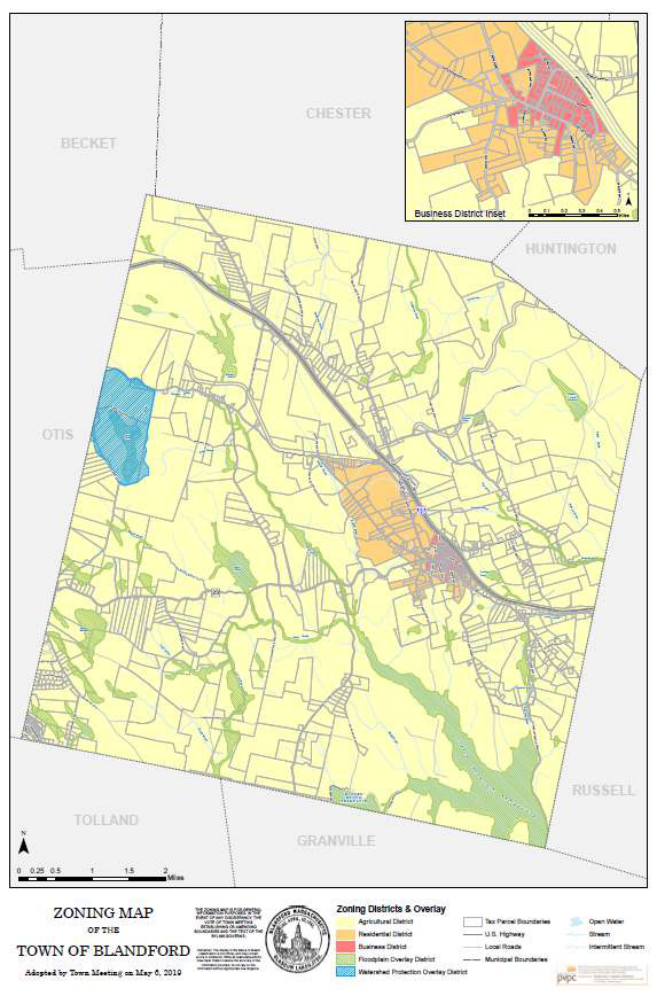
BOUNDARIES OF BUSINESS DISTRICT
Starting on the east side of Kaolin Road, at lot 21, then following the southern border of lot 21 to lot 22 and then along the southern border of lot 22 to the border of the Massachusetts Turnpike. The business district then follows westerly along the southern border of the Massachusetts Turnpike including all of the lots between the Mass Turnpike and Kaolin Road.
The business district will also include all of the property encompassed within the boundaries of Russell Stage Road, Kaolin Road, and Main Street (Rte. 23).
The business district will continue from the intersection of Russell Stage Road and Maple Lane including all of the lots between Maple Lane and the Mass Turnpike including lot 30 AKA 10 Maple Lane. Then continuing along the western border of lot 29 then west along the southern border of lot 5 then southerly along the east side of lots 8 and 9 (to the east side of north street. then south along the west side of lot 109-0-9 and along the west side of lot5 109-0-10 (aka 6 and 4 north street respectively).
Then continuing south on North Street to the junction of Main Street, (Rte. 23), and Russell Stage Road including lots 11, 12, 14, 15, 16, and 17 and excluding lot 13 also known as Watson Park. Then at the junction of Main Street and Russell Stage Road going North along Russell Stage Road to Maple Lane including all of the lots between Russell Stage Road and lot 13, (Watson Park), and then along the south side of Maple Lane to and including lot 28 aka 5 maple Lane.
The business district continues from the junction of Main Street and North Street Starting at lot 1, aka 99 Main Street, including all of the lots that border along the south side of Main Street and ending at lot 5 (aka 73) Main Street. The business district will extend to the southern border of each lot.
BOUNDARIES OF AGRICULTURAL DISTRICT
All areas not in the Business or Residential Districts.
Section IVProvisions for Districts
§ 4.1Residential District
USES PERMITTED (see Table XII- Schedule of Uses Table)
No building or land shall be used except for the following purposes:
ONE AND TWO-FAMILY DWELLINGS
No more than one (1) building designated or available for use for dwelling purposes shall be erected or placed or converted to use as such on any lot without first obtaining a permit from the Building Inspector.
The Zoning Board of Appeals shall grant a special permit for the erection of an additional building or a conversion of an additional building, on any one lot, to be used for dwelling purposes provided:
The minimum frontage of a lot in the district and the minimum area of the district for each dwelling are met.
All minimum distances between buildings and setback requirements are met.
The building Inspector obtains approval of the Planning Board prior to issuing permit.
Churches, schools, town offices and buildings, libraries, cemeteries, public parks.
Such accessory buildings or uses as are common to dwellings. The phrase "uses as are common" shall be interpreted to include the cutting of salable timber and the keeping of livestock and domestic animals and pets where such uses are not a commercial enterprise and do not conflict with the purpose of this By-Law.
The growing of agricultural crops.
Private clubs not conducted for business and the Union Agricultural and Horticultural Society.
In appropriate cases, for uses which are not specifically prohibited or already require a Special Permit from another Board, and with appropriate safeguards, the Board of Appeals may grant special permits for the following accessory uses:
Such occupations shall include but not be limited to: Architect, Hairdresser, Art Gallery, Interior Designer, Boutique, Laundress, Craft Shop, Real Estate, Dressmaker, Carpenter, Home Manufacturing, Painter, Plumber, and Electrician
Office for the practice of a recognized profession, i.e., doctor, dentist, lawyer.
Recreational facilities operated as a business provided that any accessory buildings conform to the Subdivision Regulations and are approved by the Planning Board. None of these uses should create offensive odors, noise, or unsightly appearance noticeable off the premises.
Target range; in appropriate cases and with appropriate safeguards, the Board of Appeals may grant special permits to organized groups within the Town for supervised target shooting.
Roof Mounted Solar Photovoltaic Installation
None of these uses shall create offensive odors, noise, or unsightly appearance noticeable off the promises.
Frontage and Area of Lots
The minimum frontage of lots in this district shall be 150 contiguous feet, and the minimum area shall be 30,000 square feet.
The minimum distance between a dwelling or accessory building and a street line shall be 30 feet.
The minimum distance between a dwelling or accessory building, a driveway or road or other structure such as a swimming pool or tennis court and any abutting property shall be 15 feet.
§ 4.2Business District
USES PERMITTED (see Section XII: Schedule of Uses Table)
No building or land shall be used except for the following purposes:
Any purpose authorized in the Residential District.
Offices, banks, and places of assembly.
Retail stores, salesrooms, shops for Custom work; or the making of articles to be sold at retail on the promises.
Restaurants excluding drive-ins or businesses using curb service.
Theaters, halls, and clubs.
Public or semipublic buildings.
Places of business of a barber and similar public service, baker blacksmith, builder, carpenter, caterer, clothes cleaner, confectioner, decorator dressmaker, dyer, electrician, florists furrier, and laundry, Laundromat, lumber, mail-order business, milliner, motor vehicle salesroom, milk bottling and distributing, news dealers, optician, pointer, paper hanger, pastry shop, photographer, plumber, printer, publisher, radio broadcasting studio, shoemaker, shoe repair, tailor, telegraph office, tinsmith, undertaker, upholsterer, and other similar uses.
Gasoline and oil stations and garages for storage and repair.
Any additional use, which is not specifically prohibited or already requires a Special Permit from another Board, for which the Zoning Board of Appeals may grant permission.
Roof Mounted Solar Photovoltaic Installation
Registered Marijuana Dispensary (RMD) – Requires a Special Permit and Site Plan Review issued by the Planning Board in accordance with Section XIV and IX.
FRONT YARDS
In the Business District there shall be provided in the front of every building or structure a front yard extending the full width of the lot and equal in depth to the average of the depths of yards on adjoining lots, and no-building or structure shall be erected moved, or altered, reconstructed, or enlarged so that a front yard less in clear depth shall result. Projecting eaves and uncovered steps shall not be considered as coming within the meaning of this section. Where there are not sufficient buildings in the vicinity to determine an average, the minimum depth of front yards shall be thirty (30) feet.
§ 4.3Agricultural District
USES PERMITTED (see Section XII: Schedule of Uses Table)
No building or land shall be used except for the following purposes:
Any purpose authorized in. the Residential District.
Agriculture.
Lumbering, portable sawmills, and portable planing mills.
In appropriate cases, for uses which are not specifically prohibited or already require a Special Permit from another Board, and with appropriate safeguards, the Board of Appeals may grant special permits for the following uses:
Convalescent homes/retirement homes.
Commercial kennels or stables, riding schools, provided they are on lots not less than three (3) acres and provided no dogs are kept in any building or enclosures within 150 feet of a property line. Plans must be submitted to the Planning Board.
None of these shall create offensive odors, noise, or unsightly appearance noticeable off the promises.
Roof Mounted Solar Photovoltaic Installation
Ground Mounted Solar Photovoltaic Installation – Requires a Special Permit and Site Plan Review issued by the Planning Board in accordance with Sections VII and IX.
FRONTAGE AND AREA OF LOTS
The minimum frontage of lots in this district shall be 300 contiguous feet, and the minimum area shall be 87,120 square feet.
The minimum distance between a dwelling or accessory building, a road or driveway or other structure such as swimming pool or tennis court and any abutting property shall be 15 feet.
The minimum distance between a dwelling or accessory building and a street line shall be 30 feet.
§ 4.4Long Pond Watershed Protection District
PURPOSE OF DISTRICT
A Watershed Protection District is established in the Town of Blandford for the watershed of Long Pond for the following purposes:
To protect, preserve and maintain the water table and water recharge areas within the Town, so as to preserve present sources of water supply for the public health and safety;
To protect the community from the detrimental use and development of land and water within the watershed protection district; and
To conserve the watershed area of the Town of Blandford for the health, safety, welfare, and enjoyment of its people.
INTENT OF DISTRICT
The intent of the Watershed Protection District is to include lands lying adjacent to water courses and surface water bodies which create the catchment or drainage areas of such water courses and bodies, as part of their natural drainage system. The district includes all areas designated on the Watershed Protection District Maps for the Town of Blandford, on file in the Office of the Town Clerk, which are hereby made part of the Town Zoning Map.
The Watershed Protection District is an overlay district and shall be superimposed on the other districts established by this by-law. All regulations of the Town of Blandford Zoning Bylaw applicable to such underlying districts shall remain in effect, except that where the Watershed Protection District imposes additional regulations, such regulations shall prevail.
BOUNDARIES OF DISTRICT
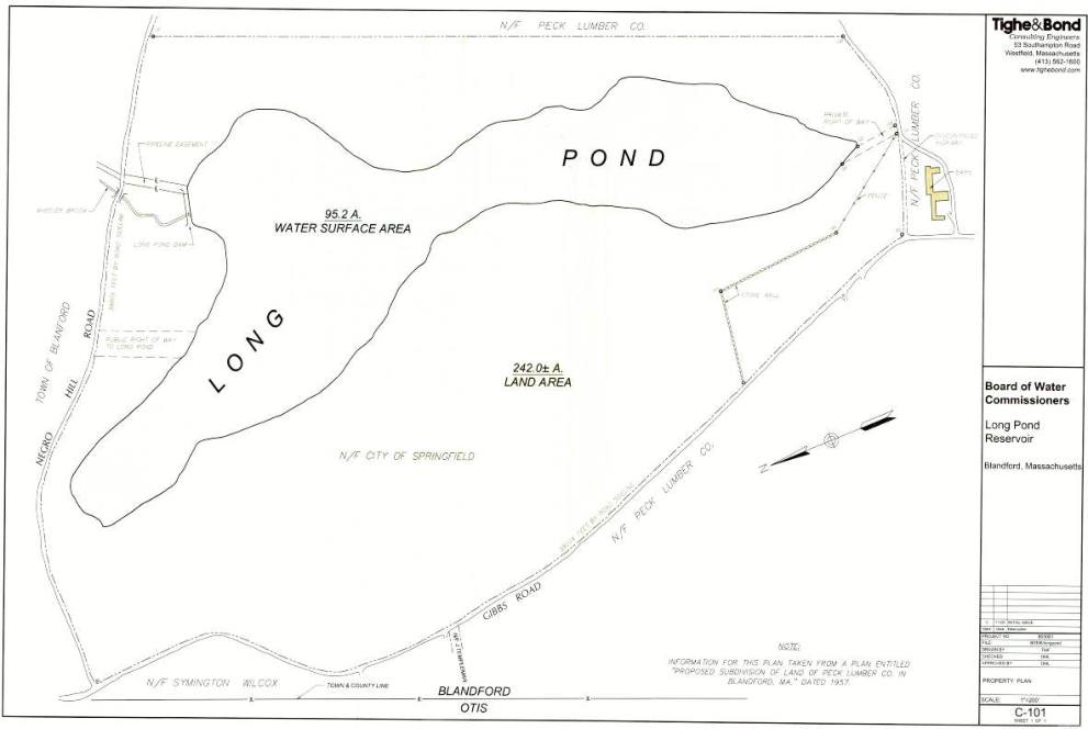
Following is a description of the boundaries of the Watershed Protection District: BEGINNING at a point on the Blandford and Otis town line, approximately 1,300 feet southerly from the center of North Blandford Road;
THENCE southeasterly about 3,600 feet to the intersection of Wheeler Brook with Jethro Jones Road;
THENCE continue southeasterly along the center of Jethro Jones Road about 1,100 feet to a point;
THENCE in a general southerly direction about 1,800 feet to an angle;
THENCE continue in a general southerly direction about 1,900 feet to the center of an old road;
THENCE westerly and southwesterly along the center of said old road about 2,300 feet to its intersection with Gibbs Road;
THENCE northwesterly about 1,200 feet to a point on the Blandford and Otis town line, at the southwest corner of parcel three as shown on Map 403 of the Town of Blandford Assessors maps;
THENCE northerly along the Blandford and Otis town line about 4,150 feet to the place of beginning.
PERMITTED USES (see Section XVI: Schedule of Uses Table)
The following uses are permitted within the Watershed Protection District, subject to Section IV, provided that all necessary permit orders, or approvals required by local, state, or federal law shall also be obtained:
Conservation of soil, water, plants, and wildlife.
Outdoor recreation, nature study, fishing, and hunting where otherwise legally permitted.
Proper operation and maintenance of existing dams, splash boards, and other water control, supply, and conservation devices.
Repair, maintenance, and reconstruction of structures and uses lawfully existing prior to adoption hereof may be continued as permitted under the Zoning Act, M.G.L. Chapter 40A.
Farming, gardening, nursery, conservation, and harvesting.
Forestry, i.e., the cutting and removal of trees for the purpose of selling said trees or any products derived there from, when carried out in the following manner.
Every reasonable effort shall be made to gain access without constructing new access ways including, but not limited to maintaining and improving (but not substantially enlarging) existing access ways, and operations shall be conducted when the soil is dry or otherwise stable, as determined by the Board of Health or an agent appointed by them.
Where access is determined impracticable without constructing new access ways, said access ways shall be designed, constructed, and maintained in accordance with U.S. Forest Service logging road standards, and shall be removed and the site returned to previously existing conditions within one year.
To ensure the faithful completion of the construction under (b) above, any person desiring to perform construction thereunder shall file with the Planning Board, in a form satisfactory to the Board, a performance bond in an amount determined by the Board or its authorized agent. Said performance bond shall be held by the Planning Board until all work required under paragraph (b) is completed in a manner satisfactory to the Board or its authorized agent.
All channel crossings shall be stabilized to prevent erosion, using standard U.S. Forest Service methods. When crossings involve fill or other closed or semi-closed structures which will obstruct flow, they shall be designed, constructed, and maintained in accordance with U.S. Forest Service standards, shall allow the unobstructed passage of existing flows for at least the 10-year storm, and shall be removed and the site returned to existing conditions within one year of construction.
All operations shall be conducted in accordance with a Forest Cutting Plan (following M.G.L. Chapter 132 Sections 40-46A) and approved by a Service Forester of the Massachusetts Department of Conservation and Recreation (as provided under 304 CMR 11.04); and a written notice describing the proposed cutting and removal of trees shall be submitted to the Conservation Commission not less than ten days prior to the commencement of operations.
The removal of the selectively cut trees shall occur only during those periods when the ground is sufficiently dry or otherwise stable to support the equipment used.
The placement of such, branches and limbs resulting from the cutting and removal operations shall not occur within 25 feet of the bank of a water body; and there shall occur no filling, excavation, or other change in the existing topography. After the cutting, the crown area of the remaining trees shall be evenly distributed throughout the site and shall cover no less than 50 percent of the surface area of the site, unless done under forestry cutting plan or joint approval of Water Department and Conservation Commission.
PROHIBITED USES
The following uses are prohibited within the Watershed Protection District:
Forestry, i.e., the cutting or removal of trees within 100 yards of the shore of Long Pond from the mean high-water line and 200 feet from the bank of all brooks and streams flowing into Long Pond, unless done under forestry cutting plan or joint approval of Water Department and Conservation Commission.
The location of landfills and the storage of salt and road de-icing chemicals.
Any new buildings, structures, land-disturbing activities, or excavations for removal of soil, sand, gravel, rocks, minerals, or any other earthen material within the Watershed Protection District, excluding required Town road maintenance.
Any animal feedlots.
The disposal of solid waste, other than brush.
The storage and/or sale of petroleum (or any other refined petroleum product) except within the buildings which it will heat.
The dumping of snow contaminated by de-icing chemicals which is brought in from outside the district.
The storage or disposal of hazardous materials, as defined by the Hazardous Waste Regulations promulgated by the Hazardous Waste Board, the Water Resources Commission, and the Division of Water Pollution Control under the provisions of Chapter 21C of Massachusetts General Laws as amended.
The storage and use of herbicides and pesticides for any purpose and the storage of fertilizers and manure or other leachable materials.
Section VAdministration & Signs
§ 5.1Plans and Permits
No building or structure shall be erected without a permit granted by the Building Inspector.
No driveway or right of way shall be constructed or connected to any traveled way or portion of a town way until written permit for same is issued by the Selectmen. The Highway Superintendent shall make proper provisions for road drainage grades, visibility, and such things of like nature necessary for the issuance of such a permit.
Applications for building permits shall contain reasonable information on forms provided by the Building Inspector.
Permits and plans are not required for accessory buildings of less than 300 square feet floor area, which are not to be used for habitation, business, or public gatherings.
§ 5.2Signs
PERMANENT SIGNS
Any sign that is permanently attached to a building or to any wall or to posts that are placed below the frost line in the ground or attached to a concrete foundation. This includes window signs or any other sign that is intended to be permanent.
Maximum size: six (6) square feet in all districts
One sign per business.
Moving signs of any type are specifically prohibited.
Illumination: Moving and flashing signs are prohibited.
No signs can be illuminated between 9pm and 6am except signs illuminating police and fire stations.
TEMPORARY SIGNS
Any sign, including its supporting structure, and which is not permanently mounted. This includes any sign designed to be transported, including but not limited to trailer signs and signs with an “A or T” frame used for support.
Yard sale signs must be placed three days before an event and removed the day after the event.
Temporary signs including property for sale or rent and contractor signs during construction are permitted and must not exceed four square feet.
No non-accessory signs shall be erected or maintained.
Temporary signs are to be maintained for a period of no more than three months.
PLACEMENT OF SIGNS
No sign may be placed within twelve (12) feet of the edge of any road or so as to constitute a hazard to pedestrians or vehicular traffic. No sign shall be placed within the clear sight triangle so as to obstruct the clear visibility at the intersection in a manner that will jeopardize the safety to vehicles or pedestrians.
Any sign, temporary or permanent, that is larger than six (6) square feet in size, must have a special permit from with the Zoning Board of Appeals.
All signs must be kept in good repair. Any sign that has peeling paint or is damaged in any way must be repaired within thirty days of notification by the building inspector or face removal.
§ 5.3Trailers
Definition: A vehicle which can be drawn, carried on or incorporated in a motor vehicle whether on temporary or permanent supports, designed for dwelling or sleeping purposes or as a temporary business of construction office.
The Board of Appeal may, in a specific case after a public hearing with due notice given subject to appropriate conditions to protect the neighborhood and Town, authorize the use of a trailer as a dwelling for a period of sixty (60) days only while a permanent dwelling is being constructed. Renewals may be granted at the discretion of the Board of Appeals for a period of thirty (30) days.
Commercial trailer bodies, i.e., moving vans, auto carriers, commercial load bodies excepting farm vehicles are specifically prohibited.
The use of a trailer as a residence for a period not to exceed twelve (12) months while a residence which has been destroyed by fire or other natural holocaust is being rebuilt is permitted in all districts.
Shipping containers are allowed for storage by special permit only. Any container must be free of lead paint and be certified as such by the Board of Health.
§ 5.4Appeals
Any person aggrieved by a decision of the Board of Appeal or any special permit granting authority, or by the failure of such Board of Appeal or special permit granting authority to take final action within the required time, may appeal from such decision or failure to act to a court of competent jurisdiction within the time and in the manner provided pursuant to G.L. c. 40A, § 17.
§ 5.5Amendments
This Bylaw, or any portion thereof, may be amended by a two-thirds vote of any Town Meeting, all in accord with the Massachusetts General Laws.
Section VIValidity
§ VIValidity
The invalidity of any section or provision of this Bylaw shall not invalidate any other section or provision thereof.
Section VIIAdministration and Procedures
§ 7.1Enforcement Officer; Penalty; Permits; Exemptions
BUILDING COMMISSIONER
The Building Commissioner appointed under the provisions of MGL c. 143 and Chapter 753 of the Acts of 1968, as amended, is hereby designated, and authorized as the officer charged with the interpretation and enforcement of this bylaw.
VIOLATIONS
If the Building Commissioner is informed or has reason to believe that any provision of this bylaw is being violated, he/she shall make or cause to be made an investigation of the facts and inspect the property where such violation may exist.
ENFORCEMENT
If upon such investigation and inspection he/she finds evidence of such violation, he/she shall give notice thereof in writing to the owner and occupant of said premises and demand that such violation be abated within such time as the Building Commissioner deems reasonable. Such notice and demand may be given by mail, addressed to the owner at his address as it then appears on the records of the Board of Assessors of the Town and to the occupant at the address of the premises.
FURTHER ACTION
If after such notice and demand the violation has not been abated within the time specified therein, the Building Commissioner shall, as he/she may be duly authorized, institute appropriate action or proceedings in the name of the Town of Blandford to prevent, correct, restrain, or abate such violation of this bylaw.
PENALTY
Anyone who violates a provision of this bylaw, including without limitation any term or condition of a variance, site plan review decision or special permit, shall be punishable by a fine of not more than $300 for each offense. Each day during which any portion of a violation continues under the provisions of this section shall constitute a separate offense.
§ 7.2Board of Appeals
ESTABLISHMENT
There shall be a Board of Appeals of three members appointed by the Board of Selectmen for five-year terms. The Board of Selectmen shall also appoint three associate members of the Board of Appeals. The appointment, service and removal or replacement of members and associate members and other actions of the Board of Appeals shall be as provided for in MGL c. 40A.
POWERS THE BOARD OF APPEALS
Shall have and exercise all the powers allowed to it by MGL Chapters 40A, 40B, and 41 and by this bylaw, including but not limited to the following:
To hear and decide applications for special permits when designated as the SPGA herein.
To grant, upon appeal or petition, with respect to particular land or structures or to an existing building thereon, a variance from the terms of this bylaw where, owing to circumstances relating to the soil conditions, shape or topography of such land or structures and owing to conditions especially affecting such parcel or such building but not affecting generally the zoning district in which it is located, a literal enforcement of the provisions of this bylaw would involve substantial hardship, financial or otherwise, to the appellant, and where desirable relief may be granted without substantial detriment to the public good and without nullifying or substantially derogating from the intent or purpose of this bylaw. The Board of Appeals shall not grant use variances.
To hear and decide appeals taken by any person aggrieved by reason of his inability to obtain a permit or enforcement action from any administrative officer under the provisions of MGL c. 40A §§ 8 and 15 or by any person including an officer or board of the Town aggrieved by an order or decision of the Building Commissioner or other administrative official in violation of any provision of Chapter 40A or of this bylaw.
To hear and decide comprehensive permits for construction of low- or moderate-income housing by a public agency or limited dividend or nonprofit corporation, as set forth in MGL c. 40B, §§ 20-23.
To sit as a board of appeals for purposes of MGL c. 41, § 81Z, and issue permits in accordance therewith.
RULES AND REGULATIONS
The Board of Appeals may adopt rules and regulations, not inconsistent with the provisions of this Zoning Bylaw, for the conduct of its business and for purposes of G.L. c.40A and shall file a copy of such rules in the office of the Town Clerk.
FEES
The Board of Appeals may adopt reasonable technical review fees for petitions for special permits, variances, administrative appeals, and applications for comprehensive permits in accordance with its regulations.
VARIANCES
The Zoning Board of Appeals may grant, upon appeal or petition, with respect to particular land or structures or to an existing building thereon, a variance from the terms of this bylaw where, owing to circumstances relating to the soil conditions, shape or topography of such land or structures and owing to conditions especially affecting such parcel or structures but not affecting generally the zoning district in which it is located, a literal enforcement of the provisions of this bylaw would involve substantial hardship, financial or otherwise, to the petitioner or appellant, and where desirable relief may be granted without substantial detriment to the public good and without nullifying or substantially derogating from the intent or purpose of this bylaw.
The Board of Appeals shall not grant use variances.
§ 7.3Planning Board
ESTABLISHMENT
Pursuant to MGL c. 41 and Chapter 753 of the Acts of 1968, there shall be a Planning Board of five elected members.
POWERS
The Planning Board shall have and exercise all the powers granted to it by MGL Chapters 40, 40A and 41 and by this bylaw, including but not limited to the following:
To hear and decide applications for special permits when designated as the SPGA herein.
To review site plans pursuant to § 9.1.
ASSOCIATE MEMBER
The Board of Selectmen shall appoint an associate member to serve for one year, or until replaced. In the case where the Planning Board is the SPGA, the Chairman of the Planning Board may have the associate member sit on the Board for the purpose of acting on a special permit application, in the case of absence, inability to act, or conflict of interest on the part of any member of the Planning Board or in the event of a vacancy on the Board.
RULES AND REGULATIONS
The Planning Board shall adopt rules and regulations not inconsistent with the provisions of the Zoning Bylaw for conduct of its business and otherwise carrying out the purposes of said Chapter 40A and this bylaw and shall file a copy of such rules in the office of the Town Clerk.
FEES
The Planning Board may adopt reasonable administrative fees and technical review fees for applications for special permits and site plan approval in accordance with its regulations.
Section VIIIGround Mounted Solar Photovoltaic Installations
§ 8.1Purpose
The purpose of this Section is to provide standards for the Placement, design, construction, operation, monitoring, modification, and removal of Ground Mounted Solar Photovoltaic installations that address public safety and minimize impacts on scenic, natural, and historic resources.
DEFINITIONS
PROJECT PROPONENT: The applicant, property owner, facility developer, operator, and management entity, jointly and severally, of a project. Each of the responsible parties shall be responsible for adhering to the requirements set forth in this bylaw.
RATED NAMEPLATE CAPACITY: The maximum rated output of Electric power production of a Photovoltaic system in Direct Current (DC).
SOLAR PHOTOVOLTAIC INSTALLATION, GROUND MOUNTED: A solar photovoltaic system that is structurally mounted on the ground and is not roof mounted.
SOLAR PHOTOVOLTAIC INSTALLATION, LARGE SCALE GROUNDMOUNTED: A solar photovoltaic system that is structurally mounted on the ground and is not roof mounted and has a rated nameplate capacity greater than 250 KW DC or occupies more than 40,000 square feet of surface area.
SOLAR PHOTOVOLTAIC INSTALLATION, MEDIUM SCALE GROUNDMOUNTED: A solar photovoltaic system that is structurally mounted on the ground and is not roof mounted and has a rated nameplate capacity between 20 KW DC and 250 KW DC or occupies greater than 1750 square feet and less than 40,000 square feet of surface area.
SOLAR PHOTOVOLTAIC INSTALLATION, SMALL SCALE GROUNDMOUNTED: A solar photovoltaic system that is structurally mounted on the ground and is not roof mounted and has a rated nameplate capacity of less than 20 KW DC or occupies less than 1750 square feet of surface area.
SOLAR PHOTOVOLTAIC INSTALLATION, ROOF MOUNTED: A solar photovoltaic system that is structurally mounted on the roof of a building.
§ 8.2Applicability
This Section applies to all ground mounted solar photovoltaic installations proposed to be constructed after the effective date of this Section. This Section also pertains to physical modifications that materially alter the type, configuration, or size of these installations or related equipment.
All Large Ground Mounted Solar Photovoltaic Installations shall require a Special Permit and Site Plan Approval issued by the Planning Board in accordance with this section and Section IX.
All Medium Ground Mounted Solar Photovoltaic Installations shall require Site Plan Approval issued by the Planning Board in accordance with this section and Section IX.
All Small Ground Mounted Solar Photovoltaic Installations with a maximum height of less than 9 feet shall require a building permit from the building inspector. Small installations with a maximum height between 9 feet and 20 feet, in addition to a building permit shall require Site Plan Approval issued by the Planning Board in accordance with this section and Section IX. Small installations with a maximum height exceeding 20 feet shall require a Special Permit and Site Plan Approval issued by the Planning Board in accordance with this section and Section IX.
§ 8.3General Requirements for All Ground Mounted Solar Photovoltaic Installations
SITE PLAN REVIEW
All Ground Mounted Solar Photovoltaic Installations shall undergo site plan review, in accordance with Section IX, prior to construction, installation or modification as provided in this Section. In addition to the submission requirements of Section IX, the following shall be required:
General - All plans and maps shall be prepared, stamped, and signed by a Professional Engineer licensed to practice in the Commonwealth of Massachusetts.
Required Documents - Pursuant to the site plan review process, the Project Proponent shall provide the following documents:
A site plan showing:
Property lines and physical features, including roads for the project site;
Proposed changes to the landscape of the site, grading, vegetation clearing and planting, exterior lighting, screening vegetation or structures;
Blueprints or drawings of the Ground Mounted Solar Photovoltaic Installations signed by a Professional Engineer licensed to practice in the
Commonwealth of Massachusetts showing the proposed layout of the system and any potential shading from nearby structures;
One- or three-line electrical diagram detailing the Ground Mounted Solar Photovoltaic Installations, associated components, and electrical interconnection methods, with all Massachusetts Electrical Code compliant disconnects and overcurrent devices;
Documentation of the major system components to be used, including the PV panels, mounting system, and inverter;
Name, address, and contact information for proposed Ground Mounted Solar Photovoltaic Installation’s installer
Name, address, phone number and signature of the Project Proponent;
The name, contact information and signature of any agents representing the Project Proponent;
Erosion and sediment control plan
Proof of liability insurance and builder’s risk insurance
A public outreach plan, including a project development timeline, which indicates how the Project Proponent will meet the required site plan review notification procedures and otherwise inform abutters and the community.
Site Control – The Project Proponent shall submit documentation of actual or prospective access and control of the project site sufficient to allow for construction and operation of the proposed Ground Mounted Solar Photovoltaic Installations.
Operation and Maintenance Plan – The Project Proponent shall submit a plan for the operation and maintenance of the Ground Mounted Solar Photovoltaic Installation, which shall include measures for maintaining safe access to the installation, storm water controls, as well as general procedures for operational maintenance of the installation.
Abandonment and Decommissioning Plan – The Project Proponent shall submit a Decommissioning Plan. Any Ground Mounted Solar Photovoltaic Installation
which has reached the end of its useful life or has been abandoned (i.e., when either it fails to be completed within a commercially reasonable time (such that power generation can commence), or it fails to operate for an elapsed time of more than one year without the written consent of the Planning Board) shall physically remove the installation within 150 days of abandonment or the proposed date of decommissioning. The Project Proponent shall notify the Planning Board by certified mail of the proposed date of the discontinued operations and plans for removal. The Abandonment and Decommissioning Plan shall include a detailed description of how all of the following will be addressed:
Physical removal of all structures; equipment, building, security barriers and transmission lines from the site, including any materials used to limit vegetation.
Disposal of all solid and hazardous waste in accordance with local, state, and federal waste disposal regulations.
Stabilization or re-vegetation of the site as necessary to minimize erosion. The Planning Board may allow the Project Proponent to leave landscaping or designated below-grade foundations in order to minimize erosion and disruption to vegetation.
Financial surety for decommissioning – Proponents of Ground Mounted Solar Photovoltaic Installations shall provide a form of surety, either through escrow account, bond or other form of surety approved by the Planning Board to cover the estimated cost of removal in the event the Town must remove the installation and remediate the landscape, in an amount ad form determined to be reasonable by the Planning Board, but in no event to exceed more than 125 percent of the cost of removal and compliance with the additional requirement set forth herein, as determined by the project proponent and the Town. Such surety will not be required for municipal or state-owned facilities. The project proponent shall submit a fully inclusive detailed itemized cost estimate of the Town’s estimated costs (including “prevailing wages”) associated with removal and full decommissioning of the facility and site, prepared by a qualified engineer. The amount shall include a mechanism for calculating increased removal costs due to inflation during the life of the facility, and the Planning Board may at any time require an increase in surety or a change in the form or security as may be required to ensure continued satisfaction of the requirements of this section. Said estimated cost shall not include or deduct the value of material recycling. Said surety in its full amount shall be presented to the Planning Board prior to the Project Proponent applying for Building Permits or the commencement of construction.
All legal documents required to enable the Town to exercise its rights and responsibilities under the plan to decommission the site, enter the property and physically remove the installation.
UTILITY NOTIFICATION
No Ground Mounted Solar Photovoltaic Installation shall be constructed until evidence has been provided to the Building Inspector that the utility company that operates the electrical grid where the installation is to be located has been informed of the Project Proponent’s intent to install the Ground Mounted Solar Photovoltaic Installation and connect it to the grid. Off grid systems shall be exempt from this requirement.
DIMENSION AND DENSITY REQUIREMENT
Ground Mounted Solar Photovoltaic Installations shall comply with the same dimension and density requirements required in the underlying district except that for such facilities of 250 kw or greater the following shall apply:
Front, rear and side yard setbacks shall be a minimum 100 feet;
Access roads or driveways shall be setback at least 25 feet from side and rear lot lines;
The height of the structures at the tallest point shall not exceed twenty- five feet;
The minimum lot size for a large-scale ground mounted photovoltaic installation is twelve (12) acres;
STRUCTURES
All structures for largescale Ground Mounted Solar Photovoltaic Installations shall be subject to existing bylaws. All appurtenant structures, including but not limited to, equipment shelters, storage facilities, transformers, and substations, shall be architecturally compatible with each other.
VISUAL IMPACT MITIGATION
The plan for a Ground Mounted Solar Photovoltaic Installation shall be designed to maximize the preservation of on-site and abutting natural and developed features. In natural (undeveloped) areas, existing vegetation shall be retained to the greatest extent possible, especially where such vegetation provides a benefit to the natural environment. In developed areas, the design of the installation shall consider and incorporate human-designed landscape features to the greatest extent, including contextual landscaping and landscape amenities that complement the physical features of the site and abutting properties. Whenever reasonable, structures should be screened from view by vegetation and/or joined or clustered to avoid adverse visual impacts and be architecturally compatible with each other. Vegetation shall be of varieties native to New England and a mix of deciduous and evergreen species. Vegetative screening shall reach a mature form to effectively screen the installation within five years of installation. The mature height of the vegetated screening shall be such that the installation’s structures are not apparent to a person upon any public road and viewing the installation from a height of 10 feet. Planting of the vegetative screening shall be completed prior to final approval of the photovoltaic installation by the Building Inspector.
DESIGN STANDARDS
Projects shall be designed to:
Minimize the volume of cut and fill, the number of removed trees 10” caliper or larger, the length of removed stone walls, the area of wetland vegetation displaced, the extent of storm water flow increases from the site, soil erosion and threat of air and water pollution.
Maximize pedestrian and vehicular safety both on the site and entering and exiting the site;
Minimize obstruction of scenic views from publicly accessible locations;
Minimize visual intrusion by controlling the visibility of parking, storage, or other outdoor service areas viewed from public ways or premises residentially used or zoned;
Minimize glare from headlights and light trespass;
Ensure adequate access to each structure for fire and service equipment and adequate provision for utilities and storm water drainage.
Site Lighting – Lighting of Ground Mounted Solar Photovoltaic Installations shall be consistent with local, state, and federal law. Lighting of other parts of the installation, such as appurtenant structures, shall be limited to that required for safety and operational purposes, and shall be reasonably shielded from abutting properties. Where feasible, lighting of the Ground Mounted Solar Photovoltaic Installation shall be directed downward and shall incorporate full cutoff fixtures to reduce light pollution.
Signage – No signage on Ground Mounted Solar Photovoltaic Installations is permitted other than those required to identify voltage and electrocution hazards as well as the owner and provide a 24-hour emergency contact phone number. Ground Mounted Solar Photovoltaic Installations shall not be used for displaying any advertising except for reasonable identification of the manufacturer or operator of Ground Mounted Solar Photovoltaic Installation.
Utility Connections – Reasonable efforts, as determined by the Site Plan Review Authority, shall be made to place all utility connections from the Ground Mounted Solar Photovoltaic Installation underground, depending on appropriate soil conditions, shape, and topography of the site and any requirements of the utility provider. Electrical transformers for utility interconnections may be above ground if required by the utility provider.
SAFETY AND ENVIRONMENTAL STANDARDS
Emergency Services - The Ground Mounted Solar Photovoltaic Installation Project Proponent shall provide a copy of the project summary, electrical schematic, and sit plan to the local fire chief. Upon request the Project Proponent shall cooperate with local emergency services in developing an emergency response plan. All means of shutting down the Ground Mounted Solar Photovoltaic Installation shall be clearly marked. The Project Proponent shall identify a responsible person for public inquiries throughout the life of the installation.
Land Clearing, Soil Erosion and Habitat Impacts - Clearing of natural vegetation shall be limited to what is necessary for the construction, operation and maintenance of the Ground Mounted Solar Photovoltaic Installation or otherwise prescribed by applicable laws, regulations, and bylaws. Such installations shall not occur on any slopes greater than 15& in order to minimize erosion. No more than 50% of the land parcel utilized for Ground Mounted Solar Photovoltaic Installations shall contain land requiring clearing of forest.
No topsoil - shall be removed from the land parcel under consideration for Ground Mounted Solar Photovoltaic Installation. If earthworks operations are required, topsoil shall be stockpiled within the property bounds and protected against erosion until such earthwork operations are completed and topsoil can be re-spread over parcel. Earthworks shall be planned to limit export of soil material (non-topsoil) to 1000 cubic yards per acre affected by installation. A detailed earthworks estimate is a required submittal component proving this quantity is maintained.
Impact on Agricultural and Environmentally Sensitive Land - The Ground Mounted Solar Photovoltaic Installation shall be designed to minimize impacts to agricultural and environmentally sensitive land and to be compatible with continued agricultural use of the land whenever possible. No more than 50% of the total land area proposed for the Ground Mounted Solar Photovoltaic Installation may be occupied by the solar panels, with the remainder of the land remaining as undeveloped open space left in its natural state.
Vegetation Management - Herbicides, pesticides, or chemical fertilizers shall not be used to manage vegetation at the Ground mounted Solar Photovoltaic Installation. Mowing, grazing, or using geotextile materials underneath the solar array are possible alternatives. Low growing grasses are optimal. Other grasses must be regularly mowed or grazed so as to minimize the amount and height of “fuel” available in case of fire.
All land - associated with the Ground Mounted Solar Photovoltaic Installation shall be covered and grown in natural vegetation. All ground surface areas beneath solar arrays and setback areas shall be pervious to maximize onsite infiltration of storm water. Impervious paving of areas beneath solar arrays is prohibited. To the greatest extent possible, a diversity of plant species shall be used, with preference given to species that are native to New England. Use of plants identified by the most recent copy of the “Massachusetts Prohibited Plant List” maintained by the Massachusetts Department of Agricultural Resources is prohibited.
MONITORING AND MAINTENANCE
Maintenance - The Project Proponent shall maintain the Ground Mounted Solar Photovoltaic Installation in good condition. Maintenance shall include, but not be limited to, painting, structural repairs, fencing and integrity of security measures. Site access shall be maintained to a level acceptable to the local Fire Chief and Emergency Medical Services. The Project Proponent shall be responsible for the cost of maintaining the Ground Mounted Solar Photovoltaic Installation and any access road(s) not accepted as public ways.
Modifications - All material modifications to a Ground Mounted Solar Photovoltaic Installation made after issuance of the required building permit shall require approval by the Special Permit and Site Plan Review Authority.
OUTSIDE CONSULTANT FEES
In accordance with G.L. c.44, §53G, the Planning Board is authorized to retain such registered professional engineers, architects, landscape architects, attorneys, or other professional consultants as may be necessary in the Planning Board’s opinion to review and advise the Board on any or all aspects of applications submitted under this Section VII. The applicant shall be responsible for the cost of such review, and the Planning Board may request the applicant to deposit funds for such review with the Planning Board in advance of such review and to replenish such funds as necessary at the Planning Board’s request. Failure to provide such funds or to pay costs of such professional review when due shall be good grounds for denial of an application.
WAIVERS
The Planning Board may, upon the prior written request of the applicant and by a 2/3 majority affirmative vote of the members of the Board, waive any of the requirements of this Section VIII, but must state their reasons for doing so in writing as part of their decision.
Section IXSite Plan Review and Special Permits
§ 9.1Site Plan Review
PURPOSE
To the health, safety, and general welfare of the inhabitants of the Town of Blandford;
To promote attractive and viable residential, business, and agricultural districts; and
To protect the rural character, aesthetic visual qualities, natural environmental features, historical features and property values of the Town of Blandford and neighboring properties.
PROJECTS REQUIRING SITE PLAN REVIEW
No building permit shall be issued and no application for such permits shall be accepted for construction, exterior alteration, relocation, or change in use except where noted in Section 6.8.3, unless a site plan has been endorsed by the Planning Board, after consultation with other boards, including but not limited to the following: Building Inspector, Board of Health, Board of Selectmen, Historical Commission, Conservation Commission, Highway Department, Fire Department and Police Department. The Planning Board may waive any or all requirements of site plan review for external enlargements of less than 10% of the existing floor area.
EXEMPTIONS FROM SITE PLAN REVIEW
Site plan review shall not be required for:
The construction or enlargement of any single family or two-family dwelling or building accessory to such dwelling;
Any building used exclusively for agriculture, horticulture, or floriculture.
APPLICATION PROCEDURE
Each application for Site Plan Review shall be submitted to the Planning Board by the current owner of record, accompanied by nine (9) copies of the site plan. The applicant shall file a copy of the application with the Town Clerk and the Tax Collector.
The Planning Board shall obtain with each submission a deposit sufficient to cover any fees connected with a public hearing and review of plans, including the costs of any engineering, or planning consultant services necessary for review purposes.
The following information shall be filed at the time of application: a site plan, which shall include landscape, utility, and drainage information, building elevations as illustrated further in Section 6.8.5, and a traffic plan.
An application shall not be considered complete until all required information and fees are submitted.
REQUIRED SITE PLAN CONTENTS
An architect, landscape architect, or professional engineer duly licensed by the Commonwealth of Massachusetts shall prepare all site plans unless the Planning Board waives this requirement because of unusually simple circumstances. All site plans shall be on standard 24" x 36" sheets at a scale of one inch equaling 20 feet, with additional narrative, as necessary. Site plans shall include the following information:
Name of the project-locus, date and scale plan;
Name and address of the owner of record, developer, and seal of the engineer, landscape architect or engineer;
The location and boundaries of the lot, adjacent streets or ways, names of owners and location of all adjacent properties and those within 300 feet of the property line, and any relevant zoning district boundaries;
Existing and proposed topography at the two-foot contour interval, the location of wetlands, streams, water bodies, drainage swales, areas subject to flooding and base flood elevations and unique natural land features;
Existing and proposed structures, including dimensions and elevations; and all exterior entrances and exits;
The location of existing and proposed parking and loading areas, public and private ways, driveways, walkways, sidewalks, curbing, access and egress points;
The location and description of all proposed septic systems, a soil percolation test, water supply, storm drainage systems including existing and proposed drain lines, culverts, drainage swales, catch basins, drainage calculations, and sub-drainage along with soil logs, utilities, hydrants, manholes, lighting fixtures, and refuse and other waste disposal methods and facilities;
Proposed landscape features including the location and a description of buffers, screening, fencing, and plantings, including the size and type of plants material;
Location, dimensions, height, color, illumination and characteristics of existing and proposed signs;
The location and a description of proposed open space or recreation areas;
A lighting plan, including parking lot and building exterior lighting and any provision of light reduction through the use of shields, screening, or similar actions;
Estimated daily and peak-hour vehicle trips to be generated by the site and traffic flow patterns for vehicles and pedestrians showing adequate access to and from the site and adequate circulation within the site;
A plan for the control of erosion, dust, and silt, both during and after construction sequencing, temporary and permanent erosion control, and protection of water bodies;
For commercial uses, maximum areas of the building to be used for selling, offices, business or other uses, number of employees, seating capacity where applicable, and number of parking spaces required for intended use.
The Planning Board may waive any information requirements it judges to be unnecessary to the review of a particular plan. A request for a waiver(s) by an applicant must be made in writing by the applicant to the Planning Board.
REVIEW PROCEDURE
The Planning Board shall transmit one copy each to the Building Inspector, Board of Selectmen, Board of Health, Conservation Commission, Highway Department, Historical Commission, Fire Department, and Police Department, who shall review the application and submit their recommendations and comments to the Planning Board concerning:
The completeness and adequacy of the data and methodology used by the applicant to determine the impacts of the proposed development;
The effects of the projected impacts of the proposed development; and
Recommended conditions or remedial measures to accommodate or mitigate the expected impacts of the proposed development.
Failure of the above boards, commissions, committees, and town staff to make recommendations within 35 days of the referral of the application from the Planning Board shall be deemed to be lack of opposition.
PLANNING BOARD DECISION
The Planning Board shall hold a public hearing within sixty-five (65) days of the receipt of an application deemed to be complete and after due consideration of the recommendations received, the Board shall take final action within 90 days from the time of hearing. The Planning Board's final action in writing shall consist of either:
Approval of the site plan based on a determination that the proposed project will constitute a suitable development and is in compliance with the standards set forth in this bylaw;
Disapproval of the site plan based on a determination that the application was incomplete and insufficient information was submitted to review the proposal; or
Approval of the project subject to any conditions, modifications and restrictions which will ensure that the project meets the Criteria for Review.
The period of review for a special permit requiring site plan review shall be the same as any other special permit and shall conform to the requirements of state Zoning Act, M.G.L. Chapter 40A. Specifically, a joint public hearing to address the Special Permit application and Site Plan Review application shall be held within sixty-five (65) days of the filing of a special permit application with the Planning Board or Board of Appeals. The Planning Board shall then have 90 days following the public hearing in which to act.
CRITERIA FOR REVIEW
The following criteria and guidelines shall be used by the Planning Board in evaluating the Site Plan and all information submitted as part of the application:
The site plan conforms with all appropriate provisions of the Zoning Bylaw.
The site plan minimizes traffic and safety impacts of the proposed development on adjacent highways or roads and maximizes the convenience and safety of vehicular and pedestrian movement within the site.
The proposed development, to the extent feasible:
is integrated into the existing landscape and protects abutting properties;
minimizes adverse environmental impacts on such features as wetlands, floodplains, and aquifer recharge areas;
minimizes obstruction of scenic views from publicly accessible locations;
preserves unique natural or historical features;
minimizes removal of trees, vegetation, and soil and grade changes,
maximizes open space retention;
screens objectionable features from neighboring properties and roadways;
complies with all State and Federal requirements for handicap access; and
offsite impacts from noise, temperature, and wind conditions.
The architectural design, layout and landscaping of the proposed development is in harmony with the historic, rural character of the neighborhood and the Town of Blandford.
The proposed development is served with adequate water supply and waste disposal systems and will not place excessive demands on Town services and infrastructure.
The site plan shows adequate measures to prevent pollution of surface or groundwater, to minimize erosion and sedimentation, to prevent changes in groundwater levels, and potential for flooding, and a stormwater management plan prepared in accordance with good engineering, hydrologic and pollution control practices.
ENFORCEMENT
The Planning Board may require the posting of a bond or other adequate security to assure compliance with the site plan and conditions and may suspend any permit or license when work is not performed as required.
Any site plan issued under this section shall lapse within one (1) year if a substantially complete use (as defined in this zoning bylaw) thereof has not commenced sooner except for good cause. The time required to pursue and await determination of a judicial appeal pursuant to Chapter 40A of the General Laws shall be included within the one (1) year time limit.
The Planning Board may periodically amend or add rules and regulations relating to the procedures and administration of this section.
§ 9.2Special Permits
SPECIAL PERMIT GRANTING AUTHORITY
Unless specifically designated otherwise, the Board of Appeals shall act as the Special Permit Granting Authority.
CRITERIA
Special permits shall be granted by the Special Permit Granting Authority, unless otherwise specified herein, only upon its written determination that the adverse effects of the proposed use will not outweigh its beneficial impacts to the town or the neighborhood, in view of the particular characteristics of the site, and of the proposal in relation to that site. In addition to any specific factors that may be set forth in this By-Law, the determination shall include consideration of each of the following:
Social, economic, or community needs which are served by the proposal;
Traffic flow and safety, including parking and loading;
Adequacy of utilities and other public services;
Neighborhood character and social structures;
Impacts on the cultural, historical, and natural environments; and
Potential fiscal impact, including impact on town services, tax base, and employment.
PROCEDURES
An application for a special permit shall be filed in accordance with the rules and regulations of the Special Permit Granting Authority.
CONDITIONS
Special permits may be granted with such reasonable conditions, safeguards, or limitations on time or use, including performance guarantees, as the Special Permit Granting Authority may deem necessary to serve the purposes of this By-Law.
PLANS
An applicant for a special permit shall submit a plan as required by and in substantial conformance with the rules and regulations of the Special Permit Granting Authority. The provisions of this Section should not apply to applications for special permits to reconstruct, extend, alter, or structurally change a nonconforming single or two-family structure. The SPGA shall establish procedures governing such applications by regulation.
REGULATIONS
The Special Permit Granting Authority may adopt rules and regulations for the administration of this section.
FEES
The Special Permit Granting Authority may adopt reasonable administrative fees and technical review fees for applications for special permits.
LAPSE
Special permits shall lapse within 24 months, not including the time required to pursue or await the determination of an appeal referred to in G.L. c. 40A, s.17, from the grant thereof, if a substantial use thereof has not sooner commenced except for good cause or, in the case of permit for construction, if construction has not begun by such date except for good cause.
Section XFlood Plain District
§ 10.1Floodplain District
STATEMENT OF PURPOSE
The purposes of the Floodplain District are to:
Ensure public safety through reducing the threats to life and personal injury;
Eliminate new hazards to emergency response officials;
Prevent the occurrence of public emergencies resulting from water quality, contamination, and pollution due to flooding;
Avoid the loss of utility services which if damaged by flooding would disrupt or shut down the utility network and impact regions of the municipality beyond the site of flooding;
Eliminate costs associated with the response and cleanup of flooding conditions;
Reduce damage to public and private property resulting from flooding waters;
To protect, preserve, and maintain the water table and water recharge areas within the Town so as to preserve present and potential water supplies for public health and safety; and
To assure the continuation of the natural flow pattern of the water course(s) within the Town in order to provide adequate and safe floodwater storage capacity to protect persons and property against the hazards of flood inundation.
FLOODPLAIN DISTRICT BOUNDARIES AND BASE FLOOD ELEVATION AND FLOODWAY DATA
Floodplain District Boundaries and Base Flood Elevation Data
The Floodplain District is herein established as an overlay district. The District includes all special flood hazard areas designated on the Town of Blandford Flood Insurance Rate Map (FIRM) issued by the Federal Emergency Management Agency (FEMA) for the administration of the NFIP dated July 26, 1974 as Zone A, which indicates the 100-year regulatory floodplain. The FIRM is incorporated herein by reference and is on file with the Town Clerk, Planning Board, Building Official, and Conservation Commission.
Base Flood Elevation and Floodway Data
Floodway Data. In Zone A along watercourses that have not had a regulatory floodway designated, the best available Federal, State, local, or other floodway data shall be used to prohibit encroachments in floodways which would result in any increase in flood levels within the municipality during the occurrence of the base flood discharge.
Base Flood Elevation Data. Base flood elevation data is required for subdivision proposals or other developments greater than 50 lots or 5 acres, whichever is the lesser, within unnumbered A zones.
NOTIFICATION OF WATERCOURSE ALTERATION
In a riverine situation, the Building Inspector shall notify the following of any alteration or relocation of a watercourse:
Adjacent Municipalities
NFIP State Coordinator
Massachusetts Department of Conservation and Recreation 251 Causeway Street, Suite 600-700 Boston, MA 02114-2104
NFIP Program Specialist
Federal Emergency Management Agency, Region I
99 High Street, 6th Floor Boston, MA 02110
USE REGULATIONS
Reference to Existing Regulations
The Floodplain Overlay District is established as an overlay district to all other districts. All regulations in the Town of Blandford Zoning Bylaw applicable to such underlying districts shall remain in effect, except that where the Floodplain Overlay District imposes additional regulations, such regulations shall prevail. All development in the district, including structural and non-structural activities, whether permitted by right or by special permit must be in compliance with Chapter 131, Section 40 of the Massachusetts General Laws and with the following:
Section of the Massachusetts State Building Code which addresses floodplain and coastal high hazard areas (currently 780 CMR 3107, "Flood Resistant Construction");
Wetlands Protection Regulations, Department of Environmental Protection (DEP) (currently 310 CMR 10.00);
Inland Wetlands Restriction, DEP (currently 310 CMR 13.00);
Minimum Requirements for the Subsurface Disposal of Sanitary Sewage, DEP (currently 310 CMR 15, Title 5);
If any variance from the above-referenced state regulations has been granted, such variance must be included in any building and/or special permit issued for a use in the Floodplain Overlay District.
Other Use Regulations
All applications for a preliminary or definitive subdivision plan must be designed to assure that:
Such plans minimize flood damage;
All public utilities and facilities are located and constructed to minimize or eliminate flood damage; and
Adequate drainage is provided to reduce exposure to flood hazards.
Existing contour intervals of site and elevations of existing structures must be included on plan proposal.
There shall be established a "routing procedure" which will circulate or transmit one copy of the development plan to the Conservation Commission, Planning Board, Board of Health, and Building Inspector for comments which will be considered by the appropriate permitting board prior to issuing applicable permits.
Permitted Uses
The following uses of low flood damage potential and causing no obstructions to flood flows are encouraged provided they are permitted in the underlying district and they do not require structures, fill, or storage of materials or equipment:
Agricultural uses such as farming, grazing, truck farming, horticulture, etc.
Forestry and nursery uses
Outdoor recreational uses, including fishing, boating, play areas, etc.
Conservation of water, plants, wildlife.
Wildlife management areas, unpaved foot, bicycle, and/or horse paths.
Temporary non-residential structures used in connection with fishing, growing, harvesting, storage, or sale of crops raised on the premises.
Structures lawfully existing prior to the adoption of these provisions.
Uses Allowed by Special Permit
No structure or building shall be erected, constructed, substantially improved over 50 percent of market value, or otherwise created or moved; no earth or other materials dumped, filled, excavated, or transferred, unless a special permit is granted by the Zoning Board of Appeals. Such permit shall be subject to the following provisions in addition to those set forth elsewhere in this Bylaw.
Application for special permit shall include plans showing all proposed work with certification by a registered professional engineer that these plans show full compliance with Section 4.5.4.1 above.
Within ten (10) days of receipt of application, a copy shall be transmitted to the Conservation Commission, Board of Health, Planning Board, and Building Inspector. Final action shall not be taken until reports have been received from all of the above, or until thirty-five (35) days from the date of transmission. A special permit shall not be granted unless the issuing Board finds, on review of the application, submitted reports, and testimony before it, that the application shows full compliance with Section 4.5.4.1 above, and that the proposed use would not create increased flood hazards which would be detrimental to the public health, safety, or welfare.
The following uses may be allowed by special permit from the Zoning Board of Appeals in accordance with the requirements of the Zoning Bylaw and the additional restrictions and criteria contained herein regarding the Floodplain Overlay District:
Single family detached dwelling;
Commercial golf course, recreation, or camp facility;
Commercial landing strip or heliport.
Within a Zone A where base flood elevation is not provided on the FIRM the applicant shall obtain any existing base flood elevation data. This data will be reviewed by the Building Inspector for their reasonable utilization toward meeting the elevation or floodproofing requirements, as appropriate, of the State Building Code.
Additional Special Permit Criteria
In addition to the Special Permit criteria specified in the Zoning Bylaw, the Zoning Board of Appeals may grant a Special Permit if it finds:
The proposed use will not create increased flood hazards which shall be detrimental to the public health, safety, and welfare.
The proposed use will comply in all respects to the provisions of the underlying District or Districts within which the land is located.
The proposed use is in compliance with all applicable state and federal laws, including the Massachusetts Building Code and the Massachusetts Wetlands Protection Act (M.G.L. Ch. 131. Section 40).
Prohibited Uses
The following uses are specifically prohibit and may not be allowed by special permit:
Solid waste landfills, junkyards, and dumps.
Business and industrial uses, not agricultural, which manufacture, use process, store, or dispose of hazardous materials or wastes as a principal
activity, including but not limited to metal plating, chemical manufacturing, wood preserving, furniture stripping, dry cleaning, and auto body repair.
The outdoor storage of salt, other de-icing chemicals, pesticides, or herbicides shall be prohibited without suitable overhead protection from weather and an impervious containment area to hold the volume of stored chemicals.
Any encroachments, including fill, new construction, substantial improvements, and other development that would result in any increase in flood levels in the community during the occurrence of the base 100-year flood discharge.
DEFINITIONS
The following Definitions shall apply to the Floodplain Overlay District.
AREA OF SPECIAL FLOOD HAZARD is the land in the floodplain within a municipality subject to a one percent or greater chance of flooding in any given year. The area may be designated as Zone A, AO, AH, A1-30, AE, A99, V1-30, VE, or V.
BASE FLOOD means the flood having a one percent chance of being equaled or exceeded in any given year.
DEVELOPMENT means any manmade change to improved or unimproved real estate, including but not limited to building or other structures, mining, dredging, filling, grading, paving, excavation, or drilling operations.
DISTRICT means floodplain district.
FEDERAL EMERGENCY MANAGEMENT AGENCY (FEMA) administers the National Flood Insurance Program. FEMA provides a nationwide flood hazard area mapping study program for municipalities as well as regulatory standards for development in the flood hazard areas.
FLOOD BOUNDARY AND FLOODWAY MAP means an official map of a municipality issued by FEMA that depicts, based on detailed analyses, the boundaries of the 100-year and 500-year floods and the 100-year floodway. (For maps done in 1987 and later, the floodway designation is included on the FIRM.)
FLOOD HAZARD BOUNDARY MAP (FHBM) means an official map of a municipality issued by FEMA where the boundaries of the flood and related erosion areas having special hazards have been designated as Zone A or E.
FLOOD INSURANCE RATE MAP (FIRM) means an official map of a municipality on which FEMA has delineated both the areas of special flood hazard and the risk premium zones applicable to the municipality.
FLOOD INSURANCE STUDY means an examination, evaluation, and determination of flood hazards, and, if appropriate, corresponding water surface elevations, or an examination, evaluation, and determination of flood-related erosion hazards.
FLOODWAY means the channel of a river or other watercourse and the adjacent land areas that must be reserved in order to discharge the base flood without cumulatively increasing the water surface elevation.
LOWEST FLOOR means the lowest floor of the lowest enclosed area (including basement or cellar). An unfinished or flood resistant enclosure, usable solely for parking of vehicles, building access or storage in an area other than a basement area is not considered a building's lowest floor, PROVIDED that such enclosure is not built so as to render the structure in violation of the applicable non-elevation design requirements of NFIP Regulations 60.3.
MANUFACTURED HOME means a structure, transportable in one or more sections, which is built on a permanent chassis and is designed for use with or without a permanent foundation when connected to the required utilities. For floodplain management purposes the term "manufactured home" also includes park trailers, travel trailers, and other similar vehicles placed on a site for greater than 180 consecutive days.
MANUFACTURED HOME PARK OR SUBDIVISION means a parcel (or contiguous parcels) of land divided into two or more manufactured home lots for rent or sale.
NEW CONSTRUCTION means structures for which the "start of construction" commenced on or after the effective date of the Floodplain Overlay District Zoning Bylaw.
ONE-HUNDRED-YEAR FLOOD - see BASE FLOOD.
REGULATORY FLOODWAY - see FLOODWAY.
SPECIAL FLOOD HAZARD AREA means an area having special flood and/or flood-related erosion hazards and shown on an FHBM or FIRM as Zone A, AO, Al-30, AE, A99, AH, V, V1 -30, VE.
STRUCTURE means a walled and roofed building, including a gas or liquid storage tank that is principally above ground, as well as a manufactured home. For the latter purpose, the term includes a building while in the course of construction, alteration, or repair, but does not include building materials or supplies intended for use in such construction, alteration, or repair, unless such materials or supplies are within an enclosed building on the premises.
SUBSTANTIAL DAMAGE means damage of any origin sustained by a structure whereby the cost of restoring the structure to its before-damaged condition would equal or exceed 50 percent of the market value of the structure before the damage occurred.
SUBSTANTIAL IMPROVEMENT means any repair, reconstruction, or improvement of a structure, the cost of which equals or exceeds 50 percent of the market value of the structure either (a) before the improvement or repair is started, or (b) if the structure has been damaged and is being restored before the damage occurred. For the purposes of this definition, "substantial improvement" is considered to occur when the first alteration of any wall, ceiling, floor, or other structural part of the building commences, whether or not that alteration affects the external dimensions of the structure.
ZONE A means the 100-year floodplain area where the base flood elevation (BFE) has not been determined. To determine the BFE, use the best available federal, state, local, or other data.
ZONE Al-30 and ZONE AE (for new and revised maps) means the 100-year floodplain where the base flood elevation has been determined.
ZONE AH and ZONE AO means the 100-year floodplain with flood depths of 1 to 3 feet.
ZONE A99 means areas to be protected from the 100-year flood by federal flood protection system under construction. Base flood elevations have not been determined.
ZONES B, C, AND X are areas identified in the community Flood Insurance Study as areas of moderate or minimal flood hazard. Zone X replaces Zones B and C on new and revised maps.
Section XIWireless Communications Facilities
§ 11.1Purpose
The Town of Blandford seeks to allow telecommunications and wireless services with minimal effect to the public health, safety, and general welfare, and to minimize the visual impact of such facilities.
§ 11.2Definitions
11.2.1 ABOVE GROUND LEVEL (AGL): A measurement of height from the natural grade of a site to the highest point of a structure.
11.2.2 CO-LOCATE: A term meaning that more than one wireless communications facility can be installed and operated on a single tower.
11.2.3 ELEVATION: The measurement of height above sea level.
11.2.4 MONOPOLE: A style of tower characterized by a single round pole having the general configuration of a flagpole. The monopole does not appear significantly larger at its base than at the point of maximum height.
11.2.5 S.P.G.A.: Special Permit Granting Authority. In Blandford, the Zoning Board of Appeals serves in this role.
11.2.6 TELECOMMUNICATIONS TOWER: A monopole structure with antennas, if any, designed to facilitate the following types of services: cellular telephone service, personal communications services, and/or enhanced specialized mobile radio service.
11.2.7 WIRELESS COMMUNICATION FACILITY: Any tower (including antennas, if any), or antenna placed on existing building or structure, or any device, wiring or equipment designed to facilitate or be utilized in connection with the provision of the following types of specialized mobile radio service as well as any structures, buildings and/or appurtenances utilized primarily for the installation and operation of equipment necessary for the provision of such services. This definition does not include an antenna used by a federally licensed amateur radio operator or television antennas or satellite dishes which are accessory to a residential use.
§ 11.3Special Permit Requirements
A wireless communications facility shall require a building permit in all cases and may be permitted as follows:
All wireless communications facilities shall require a Special Permit from the Zoning Board of Appeals.
No wireless telecommunications facilities shall be erected or installed except in compliance with the provisions of this Section. Any proposed modifications to an existing wireless communications facility including, but not limited to extension in the height, addition of antennas or panels, or construction of a new or replacement of a facility shall be subject to these provisions and shall require a new application. The SPGA may, at its discretion, waive any application requirements for modifications to existing facilities. Wireless communications facilities shall, if feasible, be located on pre- existing load-bearing structures, buildings, or towers, provided such installation shall preserve the character of the structure, building or tower. The applicant shall demonstrate that there are no pre-existing structures, buildings, or towers available prior to approaching the SPGA with an application proposing the construction of a new structure or mount for an antenna. If there are no feasible pre-existing structures, buildings, or towers, then wireless communication facilities shall, if feasible, be located on public land. All newly constructed wireless communications facilities shall be located in the Agricultural district.
New towers shall be free-standing monopoles.
Providers of wireless communication services shall report to the Building Inspector and the SPGA any cessation in the use or operation of any wireless communications facility that exceeds 30 days. All facilities, attachments, and accessory structures which have not been used for a period of one (1) year shall be dismantled and removed at the owner’s expense. The applicant shall post an initial bond to cover demolition costs and to cover the removal of the facility in the event of non- operation in an amount approved by the Zoning Board of Appeals. Said bond shall be posted with the Town Treasurer.
§ 11.4Siting and Construction Guidelines
The following guidelines shall be used when preparing plans for the siting and construction of all wireless communications facilities:
To the maximum extent possible, all service providers will co-locate on a single structure. Structures shall be designed to accommodate the maximum number of users technologically practical. The intent of this condition is to reduce the number of towers located within Blandford.
No tower, including any attachments, shall be erected nearer to any existing structure than a distance equal to 125 % of its vertical height.
All towers shall be pre-engineered to fail at a pre-determined height enabling the structure to collapse upon itself in the event of a catastrophic failure.
No wireless communications facility shall exceed 200 feet in height as measured from the mean finished grade at the base of the tower. Exterior lighting of the towers and any accessory structures shall be prohibited.
Facilities shall not be located within 1500 feet of the peak of a significant hill or located in such a way as to adversely impact the view of a significant hill in the community.
Siting shall be such that the view of the facility and tower shall be as limited as possible when viewed off-site. Facilities shall be screened to provide an effective year-round visual buffer. The buffer shall be of sufficient height and depth to sufficiently screen the facility. The Special Permit Granting Authority shall determine the types of plant materials and the size of the buffer based on conditions on the site. Existing vegetation shall be used for screening wherever possible.
Existing on-site vegetation shall be preserved to the maximum extent practicable. Clearing of land shall be performed in a manner which will maximize preservation of natural beauty and conservation of natural resources and which will minimize scarring of the landscape or sitting of streams or wetlands.
All wireless communications facilities shall be painted, colored, and/or constructed of materials that minimize the visual impact of the facility on adjacent abutters, residential neighbors, and other areas of town and blend in with the surrounding landscape or the structure on which they are located.
Fencing shall be provided to control access to wireless communications facilities and shall reflect the visual character of the neighborhood or natural surroundings.
Signage is limited to providing the following information and must adhere to the Town's current signage bylaw; the facility, the owner and operator and an emergency telephone number where the owner can be reached on a twenty-four (24) hour basis must be clearly displayed; a no trespassing sign; a sign displaying the Federal Communications Commission registration number; and any signs required to warn of danger.
There shall be a minimum of one (I) parking space for each facility, to be used in connection with the maintenance of the site. There shall be no storage of vehicles or equipment on the site.
To the extent feasible, all network interconnections from the communications site shall be via land lines.
Applicants proposing to erect wireless communications facilities on municipally-owned land or structures shall provide evidence of contractual authorization from the Town of Blandford to conduct wireless communications services on municipally owned property.
§ 11.5Application Requirements
For an application to be considered complete, the following information must be submitted:
A color photograph or rendition of the proposed wireless communication facility including, but not limited to, the proposed tower with its antenna and/or panels. A rendition shall also be prepared illustrating views of the proposed wireless communication facility from the surrounding areas.
A landscape plan showing the proposed site before and after development including topography and screening proposed to protect abutters.
A description of the wireless communication facility including, but not limited to, the height of any towers and antennas, access roads and power supplies, the type, size and number of transmitters and a technical report which demonstrates that the maximum height of the installation is the minimum feasible to provide the intended service.
The technical and other reasons for the proposed location, height and design including, but not limited to, a survey of all sites which are feasible for providing the intended services both within and directly adjacent to the Town of Blandford and the reason(s) the proposed site was selected over at least one alternative site.
A survey of all pre-existing structures, buildings or towers which are capable of supporting the equipment necessary to provide the intended service, and a technical report which demonstrates why any such structure, building or tower cannot be used by the applicant.
A description of the capacity of the tower including the number and type of panels, antenna and/or transmitter receivers that it can accommodate, and the basis for these calculations.
A statement that the sound levels under normal operating conditions, whether emanating directly from, or as a result of natural wind blowing through the wireless communications facility, measured at the boundary of the total on which it is sited, shall not be greater than would otherwise exist in the absence of such facility.
A statement of the services to be supported by the proposed wireless communication facility and a delineation on the Zoning District Map of all areas in Blandford which will not be served by the proposed installation for the primary site and an alternate site.
A description of the special design features utilized to minimize the visual impact of the proposed wireless communication facilities.
A certification that the applicant possesses all necessary licenses to operate such a facility and has complied with all federal and state requirements to provide the proposed service.
Within thirty days after riling the application for any new tower or extension in height (hereto, the applicant shall arrange to fly a balloon at the primary and an alternate site at the maximum height of the proposed installation on a weekend day and one weekday between the hours of 10 a.m. and 6 p.m. The balloon shall be of size and color that can be seen from every direction for a distance of one mile. The applicant shall be responsible for posting the date and location of the balloon(s) as a legal advertisement at least 14 days, but not more than 21 days before the flights in at least two different issues of a newspaper with a general circulation in the Town of Blandford.
§ 11.6Severability
The invalidity, unconstitutionality, or illegality of any provision in this bylaw shall not have any effect upon the validity, constitutionality, or legality of any other provision of this bylaw.
Section XIISection Reserved
§ XIISection Reserved
Section XIIISection Reserved
§ XIIISection Reserved
Section XIVRegistered Marijuana Dispensary (RMD)
§ 14.1Registered Marijuana Dispensary (RMD)
PURPOSES
It is recognized that the nature of the substance cultivated, processed, and/or sold by Registered Marijuana Dispensaries may have objectionable operational characteristics and should be located in such a way as to ensure the health, safety, and general well-being of the public as well as patients seeking treatment. The specific and separate regulation of Registered Marijuana Dispensaries (RMD) is necessary to advance these purposes and ensure that such facilities are not located within close proximity of minors and do not become concentrated in any one area within the Town of Blandford.
Subject to the provisions of this Zoning By-law, Chapter 40A of the General Laws, Chapter 369 of the Acts of 2012; chapter 941 (Medical Use of Marijuana) of the General Laws, and all regulations which have or may be issued thereunder, including, but not limited to 105 CMR 725.000, et seq., Registered Marijuana Dispensaries will be permitted to provide medical support, security, and physician oversight that meet or exceed state regulations.
ADDITIONAL REQUIREMENTS/CONDITIONS
In addition to the standard requirements for uses permitted By-right or requiring Permit Site Plan Approval, the following shall also apply to all Registered Marijuana Dispensaries:
Use:
RMD’s may only be involved in the uses permitted by its definition and may not include other businesses or services.
No marijuana shall be smoked, eaten, or otherwise consumed or ingested within the premises.
The hours of operation shall be set by Special Permit Granting Authority, but in no event shall an RMD be open to the public, and no sale or other distribution of marijuana shall occur upon the premises or via delivery from the premises, between the hours of 8:00 p.m. and 8:00 a.m.
Physical Requirements
All aspects of the RMD use/facility relative to the acquisition, cultivation, possession, processing, sales, distribution, dispensing, or administration of marijuana, products containing marijuana, related supplies, or educational materials must take place at a fixed location within a fully enclosed building and shall not be visible from the exterior of the business.
No outside storage is permitted.
No RMD facility which serves only to dispense the processed marijuana, related supplies, and educational materials to registered Qualifying Patients or their personal caregivers in accordance with the provisions of 105 CMR 725.00 shall have a gross floor area in excess of 2,500 square feet.
Ventilation – all RMD facilities shall be ventilated in such a manner that no:
Pesticides, insecticides or other chemicals or products used in the cultivation or processing are dispersed into the outside atmosphere, and
No odor from marijuana or its processing can be detected by a person with an unimpaired and otherwise normal sense of smell at the exterior of the medical marijuana business or at any adjoining use or property.
Signage shall be displayed on the exterior of the RMD facility’s entrance in plain sight of clients stating that “Registration Card issued by the MA Department of Public Health required” in text two inches in height.
Location
No RMD shall be located on a parcel which is within five hundred (500) feet (to be measured in a straight line from the nearest points of each property line) of a parcel occupied by:
A public or private elementary, junior high, middle, vocational, or high school, college, junior college, university or childcare facility or any other use in which children commonly congregate in an organized, ongoing, and formal basis, or
another RMD.
No RMD shall be located inside a building containing residential units, including transient housing such as motels and dormitories.
Reporting Requirements
All Special Permit and Site Plan Approval holders for an RMD shall provide the Police Department, Fire Department, Building Commissioner/Inspector and the Special Permit Granting Authority with the names, phone numbers and email addresses of all management staff and key-holders, including a minimum of two (2) operators or managers of the facility identified as contact persons to whom one can provide notice if there are operating problems associated with the establishment. All such contact information shall be updated as needed to keep it current and accurate.
The local Building Commissioner/Inspector, Board of Health, Police Department, Fire Department and Special Permit Granting Authority shall be notified in writing by an RMD owner/operator/manager:
A minimum of 30 days prior to any change in ownership or management of that facility
A minimum of 12 hours following a violation or potential violation of any law or any criminal or potential criminal activities or attempts of violation of any law at the RMD.
RMD’s shall file an annual report with and appear before the Special Permit Granting Authority no later than January 31st of each year, providing a copy of all current applicable state licenses for the facility and/or its owners and demonstrate continued compliance with the conditions of the Special permit.
Issuance/Transfer/Discontinuance of Use
Special Permits/Site Plan Approvals shall be issued to the RMD Operator;
Special Permits/Site plan Approvals shall be issued for a specific site/parcel;
Special Permits/Site Plan Approvals shall be non-transferable to either another RMD Operator or site-parcel;
Special Permits/Site plan Approvals shall have a term limited to the duration of the applicant’s ownership/control of the premises where the RMD is located, and shall lapse;
If the permit holder ceases operation of the RMD, and/or
The permit holder’s registration by MDPH expires or is terminated;
The permit holder shall notify the Zoning Enforcement Officer and Special Permit Granting Authority in writing within 48 hours of such lapse, cessation, discontinuance, or expiration.
An RMD shall remove all material, plants, equipment, and other paraphernalia prior to surrendering its state Registration or ceasing its operation.
Prior to the issuance of a Building Permit for a RMD, the applicant shall provide the Town a bond or other form of financial security in amount and form acceptable to the Planning Board. The amount shall be sufficient to cover the costs to the Town of removing all materials, plants, equipment, and other paraphernalia if the applicant fails to do so.
The Town, acting by and through the Building Inspector, shall provide the applicant 45 days written notice in advance of claiming and applying security. Should the applicant remove all materials, plants, equipment, and other paraphernalia to the satisfaction of the Building Inspector prior to the expiration of the 45 days written notice, the security shall be released to the applicant.
APPLICATION REQUIREMENTS
All Registered Marijuana Dispensaries (RMD) require a Special Permit and Site Plan Review issued by the Planning Board in accordance with these bylaws and Section IX. In addition to the standard application requirements for Special Permits and Site Plan Approvals, such applications for an RMD shall also include the following:
The name and address of each owner of the RMD;
A copy of its registration as an RMD from the Massachusetts Department of Public Health or documentation demonstrating that said RMD, and its owner/operators, qualify and are eligible to receive a Certificate of Registration and meet all of the requirements of an RMD in accordance with 105 CMR 725.000;
Evidence that the Applicant has site control and right to use the site for a RMD facility in the form of a deed or valid purchase and sales agreement or, in the case of a lease a notarized statement from the property owner and a copy of the lease agreement;
A notarized statement signed by the RMD’s Chief Executive Officer and corporate attorney disclosing all of its designated representatives, including officers, directors, shareholders, partners, members, managers, or other similarly situated individuals and entities and their addresses. If any of the above are entities rather than persons, the Applicant must disclose the identity of all such responsible individual persons;
In addition to what is normally required in a Site Plan, details showing all exterior proposed security measures for the RMD including lighting, fencing, gates and alarms, etc. ensuring the safety of employees and patrons and to protect the premises from theft or other criminal activity;
A detailed floor plan identifying the areas available and functional use (including square footage);
All signage being proposed for the facility;
A traffic study to establish the impacts at peak demand times;
A Management Plan including a description of all activities to occur on site including all provisions for the delivery of medical marijuana and related products, including off-site direct delivery to patients.
FINDINGS
In addition to the standard Findings for a Special Permit or Site Plan Approval, the Special Permit Granting Authority must also find all the following:
That the RMD facility is designed to minimize any adverse visual or economic impacts on abutters and other parties in interest;
That the RMD demonstrates that it will meet all the permitting requirements of all the applicable agencies within the Commonwealth of Massachusetts and will be in compliance with all applicable state laws and regulations;
That the applicant has satisfied all of the conditions and requirements of this Section and other applicable sections of the Zoning By-law;
That the RMD facility provides adequate security measures to ensure that no individual participant will pose a direct threat to the health or safety of other individuals, and that the storage and/or location of cultivation is adequately secured;
That the RMD facility adequately addresses issues of traffic demand, circulation flow, parking, and queuing, particularly at peak periods at the facility and its impact on neighboring uses.
Section XVAdult Use Marijuana Establishments
§ 15.1Purpose
The purpose of this bylaw is to allow for the siting of state-licensed Marijuana Establishments in appropriate locations in accordance with applicable state laws and regulations regarding adult use marijuana in accordance with state law, including G.L. c.94G and 935 CMR 500.00 and G.L. c.94I and 105 CMR 725.00 and to impose reasonable safeguards to govern the time place and manner of Marijuana Establishments to ensure public health, safety, well-being and mitigate against undue impacts on the town and its residents.
§ 15.2Requirements/Conditions
The Planning Board shall be the Special Permit Granting Authority and Site Plan Review authority for Marijuana Establishments. In addition to the standard requirements for uses permitted by-right or requiring a Special Permit or Site Plan Approval, as set forth in Sections V and IX of the By-law, the following shall also apply to all Marijuana Establishments:
USE
Any type of Marijuana Establishment may only be involved in the uses permitted by its definition and may not include other businesses or services.
No marijuana shall be smoked, eaten, topically applied, or otherwise consumed or ingested within the premises of any Marijuana Establishment unless expressly permitted under this law and permitted by state law or regulation.
The hours of operation shall be set by the Special Permit Granting Authority, but in no event shall a Marijuana Establishment other than a Marijuana Retailer be open to the public, and no sale or other distribution of marijuana shall occur upon the premises or via delivery from the premises of a Marijuana Retailer between the hours of 8:00 p.m. and 8:00 a.m.
No marijuana establishment may commence operation prior to its receipt of all required permits and approvals including, but not limited, to its Final License from the Cannabis Control Commission.
The number of Marijuana Retailers permitted to be located within the Town of Blandford shall not exceed 20% of the number of licenses issued within the town for the retail sale of alcoholic beverages not to be drunk on the premises where sold under chapter 138 of the General Laws. For the purposes of determining this number, any fraction shall be rounded up to the next highest whole number.
PHYSICAL REQUIREMENTS
All aspects of the any Marijuana Establishment, except for the transportation of product or materials, relative to the acquisition, cultivation, possession, processing, sales, distribution, dispensing, or administration of marijuana, products containing marijuana, related supplies, or educational materials must take place at a fixed location within a fully enclosed building (including greenhouses) and shall not be visible from the exterior of the business. Marijuana Establishments may not be located within a trailer, storage freight container, motor vehicle or other similar type potentially movable enclosure.
No outside storage is permitted.
No Marijuana Retailer shall have a gross floor area open to the public in excess of 2,500 square feet.
Ventilation – all Marijuana Establishments shall be ventilated in such a manner that no:
Pesticides, insecticides or other chemicals or products used in the cultivation or processing are dispersed into the outside atmosphere
No odor from marijuana or its processing can be detected by a person with an unimpaired and otherwise normal sense of smell at the exterior of the Marijuana Establishment or at any adjoining use or property.
Signage shall be displayed on the exterior of the Marijuana Establishment’s entrance in plain sight of the public stating that “Access to this facility is limited to individuals 21 years or older.” in text two inches in height. All other signage must comply with all other applicable signage regulations in the Zoning By-law and 935 CMR 500.
Marijuana plants, products, and paraphernalia shall not be visible from outside the building in which the Marijuana Establishment is located and shall comply with the requirements of 935 CMR 500. The Board may require or allow the use of vegetative and artificial screening to eliminate the view from the public way. In making its determination, the Board shall consider the surrounding landscape and viewshed, and may require a vegetative screen in addition to or in place of artificial screening if an artificial screen would be out of character with the neighborhood.
LOCATION
Marijuana Establishments are encouraged to utilize existing vacant buildings where possible.
No Marijuana Establishment shall be located on a parcel which is within three hundred (300) feet (to be measured in a straight line from the nearest point of the property line in question to the nearest point of the property line where the Marijuana Establishment is or will be located) of a parcel occupied by a preexisting public or private school chartered by the state (existing at the time the applicant’s license application was received by the Cannabis Control Commission) (homeschools are not included) providing education in kindergarten or any of grades 1-12.
No Marijuana Retailer shall be located on a parcel which is within three hundred (300) feet (to be measured in a straight line from the nearest point of the property line in question to the nearest point of the property line where the marijuana retailer is or will be located) of a parcel occupied by another Marijuana Retailer.
No Marijuana Establishment shall be located within the town’s Residential Zoning District.
No Marijuana Establishment shall be located inside a building containing residential units, including transient housing such as motels and dormitories.
No Marijuana Establishment is permitted to utilize or provide a drive through service.
REPORTING REQUIREMENTS
Prior to the commencement of the operation or services provided by a Marijuana Establishment, the owner/applicant shall provide the Police Department, Fire Department, Building Commissioner/Inspector and the Special Permit Granting Authority with the names, phone numbers and email addresses of all management staff and key-holders, including a minimum of two (2) operators or managers of the facility identified as contact persons to whom one can provide notice if there are operating problems associated with the establishment. All such contact information shall be updated as needed to keep it current and accurate.
The local Building Commissioner/Inspector, Board of Health, Police Department, Fire Department and Special Permit Granting Authority shall be notified in writing by the Marijuana Establishment facility owner/operator/ manager:
A minimum of 30 days prior to any change in ownership or management of that establishment.
A minimum of 12 hours following a violation or potential violation of any law or any criminal or potential criminal activities or attempts of violation of any law at the establishment or by its employees.
Permitted Marijuana Establishments shall file an annual written report to, and appear before, the Special Permit Granting Authority no later than January 31st of each calendar year, providing a copy of all current applicable state licenses for the facility and/or its owners and demonstrate continued compliance with the conditions of the Special Permit/Site Plan Approval.
The owner or manager of a Marijuana Establishment is required to respond by phone or email within twenty-four hours of contact by a duly authorized town official concerning their Marijuana Establishment at the phone number or email address provided to the town as the contact for the business.
ISSUANCE/TRANSFER/DISCONTINUANCE OF USE
Special Permits/Site Plan Approvals shall be issued to the Marijuana Establishment owner.
Special Permits/Site Plan Approvals shall be issued for a specific type of Marijuana Establishment on a specific site/parcel.
Special Permits/Site Plan Approvals shall be non-transferable to either another Marijuana Establishment owner or another site/parcel.
Special Permits/Site Plan Approvals shall have a term limited to the duration of the applicant’s ownership/control of the premises as a Marijuana Establishment, and shall lapse/expire if,
the Marijuana Establishment ceases operation (not providing the operation or services for which it is permitted) for 365 days, and/or
the Marijuana Establishment’s registration/license by the Cannabis Control Commission expires or is terminated.
The Marijuana Establishment shall notify the Zoning Enforcement Officer and Special Permit Granting Authority in writing within 48 hours of such lapse, cessation, discontinuance or expiration or revocation.
A Marijuana Establishment shall be required to remove all material, plants equipment and other paraphernalia prior to surrendering its state registration/license or ceasing its operation.
Prior to the issuance of a Building Permit for a Marijuana Establishment the applicant shall post with the Town Treasurer a bond or other form of financial security acceptable to said Treasurer in an amount set by the Planning Board.
The amount shall be sufficient to cover the costs of the town removing all materials, plants, equipment, and other paraphernalia if the applicant fails to do so. The Building Inspector shall give the applicant 45 days’ written notice in advance of taking such action. Should the applicant remove all materials, plants, equipment, and other paraphernalia to the satisfaction of the Building Inspector prior to the expiration of the 45 days written notice, said bond shall be returned to the applicant.
§ 15.3Application Requirements
Applications for Special Permits and Site Plan Approvals for Marijuana Establishments will be processed in the order that they are filed with the town. In addition to the standard application requirements for Special Permits and Site Plan Approvals, such applications for a Marijuana Establishment shall include the following:
The name and address of each owner and operator of the marijuana establishment.
A copy of an approved and fully executed Host Community Agreement.
A copy of its Provisional License from the Cannabis Control Commission pursuant to 935 CMR 500.
If the Marijuana Establishment will be operated in conjunction with an approved RMD, a copy of its registration as an RMD from the Massachusetts Department of Public Health in accordance with 105 CMR 725.000 or from the Cannabis Control Commission in accordance with 935 CMR 500.
Proof of Liability Insurance Coverage or Maintenance of Escrow as required in 935 CMR 500.
Evidence that the Applicant has site control and right to use the site for a Marijuana Establishment in the form of a deed or valid purchase and sales agreement or, in the case of a lease a notarized statement from the property owner and a copy of the lease agreement.
A notarized statement signed by the Marijuana Establishment organization’s Chief Executive Officer and corporate attorney disclosing all of its designated representatives, including officers, directors, shareholders, partners, members, managers, or other similarly situated individuals and entities and their addresses. If any of the above are entities rather than persons, the Applicant must disclose the identity of all such responsible individual persons.
In addition to what is normally required in a Site Plan, details showing all exterior proposed security measures for the Marijuana Establishment including lighting, fencing, gates, and alarms, etc. ensuring the safety of employees and patrons and to protect the premises from theft or other criminal activity.
A detailed floor plan identifying the areas available and functional uses (including square footage).
All signage being proposed for the Marijuana Establishment.
A pedestrian/vehicular traffic impact study to establish the Marijuana Retailer’s impact at peak demand times, including a line queue plan to ensure that the movement of pedestrian and/or vehicular traffic, including but not limited to, along the public right of ways will not be unreasonably obstructed.
An odor control plan detailing the specific odor-emitting activities or processes to be conducted on-site, the source of those odors, the locations from which they are emitted from the Marijuana Establishment, the frequency of such odor-emitting activities, the duration of such odor-emitting activities, and the administration of odor control including maintenance of such controls.
A Management Plan including a description of all activities to occur on site, including all provisions for the delivery of marijuana and related products to the Marijuana Establishment or off-site direct delivery.
Individual written plans which, at a minimum comply with the requirements of 935 CMR 500, relative to the Marijuana Establishment’s:
Operating procedures
Waste disposal
Transportation and delivery of marijuana or marijuana products
Energy efficiency and conservation
Security and Alarms
Decommissioning of the Marijuana Establishment including a cost estimate taking into consideration the community’s cost to undertake the decommissioning of the site.
§ 15.4Findings
In addition to the standard Findings for a Special Permit or Site Plan Approval the Special Permit Granting Authority must also find all the following:
The Marijuana Establishment is consistent with and does not derogate from the purposes and intent of this Section and the Zoning By-law.
That the Marijuana Establishment facility is designed to minimize any adverse visual or economic impacts on abutters and other parties in interest;
That the Marijuana Establishment meets or exceeds all the permitting requirements of all applicable agencies within the Commonwealth of Massachusetts and will be in compliance with all applicable state laws and regulations;
That the applicant has satisfied all of the conditions and requirements of this Section and other applicable Sections of this By-law;
That the Marijuana Establishment provides adequate security measures to ensure that no individual participant will pose a direct threat to the health or safety of other individuals, and that all operations of the facility, including storage, cultivation, and delivery are adequately secured on-site and via delivery.
That the Marijuana Establishment facility adequately addresses issues of traffic demand, circulation flow, parking, and queuing, particularly at peak periods at the facility, and its impact on neighboring uses.
Section XVIBattery Energy Storage Systems
§ 16.1Purpose
The purpose of this bylaw is to provide for the construction and operation of Battery Energy Storage Systems (BESS) and to provide standards for the placement, design, construction, monitoring, modification and removal of energy storage systems that address public safety, minimize impacts on scenic, natural and historic resources of the Town of Blandford and provide adequate financial assurance for decommissioning. The provisions set forth in this section shall take precedence over all other sections when considering applications related to the construction, operation, and/or repair of Battery Energy Storage Systems.
§ 16.2Definitions
BATTERY OR BATTERIES – a single cell or a group of cells connected together electrically in series, in parallel, or a combination of both, which can charge, discharge, and store energy electrochemically. For the purposes of this bylaw, batteries utilized in consumer products are excluded from these requirements.
BATTERY ENERGY STORAGE SYSTEM – a physical container providing secondary containment to one or more battery cells for storing electrical energy derived from solar or sourced directly from the grid that is equipped with cooling, ventilation, fire suppression, and an electronic battery management system. It may be a primary use or accessory to a solar energy facility, power generation facility, an electrical sub-station, or other similar uses. A Battery Energy Storage System can be classified as a Tier 1, Tier 2, or Tier 3 Battery Energy Storage System, as follows:
Tier 1 Battery Energy Storage Systems are defined as those that have an aggregate energy capacity up to 20kWh and greater and, whose purpose is to store energy from residential solar energy systems if in a room or enclosed area, consist of only a single energy storage system technology. The facility must comply with the State’s electrical code (527 CMR. 12.00) and the State’s Fire Code (527 CMR 1.00).
Tier 2 Battery Energy Storage Systems are defined as those that are interconnected to utility distribution lines and have an aggregate energy capacity greater than 20kWh but less than or equal to 10 Megawatts. The facility must comply with the State’s electrical code (527 CMR. 12.00) and the State’s Fire Code (527 CMR 1.00).
Tier 3 Battery Energy Storage Systems are defined as those that are interconnected to high voltage transmission lines and have an aggregate energy capacity greater than 10 Megawatts. The facility must comply with the State’s electrical code (527 CMR. 12.00) and the State’s Fire Code (527 CMR 1.00).
§ 16.3Applicability
Building-integrated Battery Energy Storage Systems
Battery Energy Storage Systems that are building-integrated, whether a residential or commercial building, energy storage systems shall not be erected, constructed, installed, or modified as provided in this section without first obtaining a building permit from the Building Inspector.
Building-integrated energy storage systems may be coupled with rooftop solar or behind the meter applications for peak shaving.
Building-integrated battery energy storage systems may be located in any zoning district within the Town of Blandford.
Co-located Battery Energy Storage Systems
Battery Energy Storage Facilities are encouraged to co-locate with solar photovoltaic installations, energy, power generation stations, and electrical sub-stations.
Battery Energy Storage Systems associated with on-site solar power generation shall be permitted in all districts where solar photovoltaic installations are permitted with a Special Permit and Site Plan Approval, and shall be subject to the requirements of this Zoning Bylaw applicable to the co-located solar photovoltaic installations, in addition to the requirements set forth herein.
Battery Energy Storage systems not associated with on-site solar generation shall only be permitted in the Agricultural Zoning District and shall require a Special Permit from the Planning Board.
Modifications to, retrofits or replacements of an existing battery energy storage system that increase the total battery energy storage system designed discharge duration or power rating shall be subject to this bylaw.
§ 16.4General Requirements
All Tier 2 and 3 battery energy storage systems shall require a special permit and site plan approval by the Planning Board prior to construction, installation, or modification as provided in this bylaw.
The construction, operation, and decommissioning of all battery storage energy storage systems shall be consistent with all applicable local, state, and federal requirements, including but not limited to all applicable environmental, safety, construction, fire, and electrical requirements.
A building permit and an electrical permit shall be required for installation of all battery energy storage systems.
§ 16.5Application Materials
In addition to requirements for Special Permit and Site Plan Approval, in accordance with Section IX, the application shall include the following:
A site plan prepared, stamped and signed by a Professional Engineer licensed to practice in Massachusetts, that shows the following:
An existing conditions plan with property lines and physical features, including topography and roads, characteristics of vegetation (trees- mature, old growth, shrubs, open field, etc), wetlands, streams, ledge, for the project site;
Proposed changes to the landscape of the site, including grading, vegetation clearing and planting, exterior lighting, screening vegetation or structures, driveways, snow storage, and storm water management systems; including total acreage of disturbed area, total vegetation cleared, not including mowed fields;
Trees with a DBH of 20” or greater within project parcel(s) shall be identified to determine tree loss, along with inventorying of diseased or hazard trees slated to be removed due to proposed development;
Property lines and physical dimensions of the subject property with contour intervals of no more than 10 feet;
Property lines of adjacent parcels within 30 feet;
Location, dimensions, and types of existing major structures on the property;
Location of the proposed battery energy storage structures, foundations, and associated equipment;
The right-of-way of any public road that is contiguous with the property;
Any overhead or underground utilities;
At least one color photograph of the existing site, measuring eight inches by 10 inches.
Locations of floodplains or inundation areas for moderate or high hazard dams;
Locations of local or National Historic Districts.
Stormwater management and erosion and sediment control
A preliminary equipment specification sheet that documents the proposed battery energy storage system components, inverters and associated electrical equipment that are to be installed, including manufacturer and model. A final equipment specification sheet shall be submitted prior to the issuance of building permit;
One- or three-line electrical diagram showing associated components, and electrical interconnection methods, with all NEC compliant disconnects and overcurrent devices;
Contact information and signature of the project proponent, as well as all co-proponents, if any, and all property owners;
Contact information and signature of agents representing the project proponent, if any;
Contact information for the person(s) responsible for public inquiries throughout the life of the system;
An operations and maintenance plan for Battery Energy Storage System. Such plan shall describe continuing battery energy storage system maintenance and property upkeep, as well as design, construction, installation, testing and commissioning information;
Energy Storage System technical specifications, including manufacturer and model;
Electrical schematic;
Documentation that shows the owner of the Energy Storage System has site control, which shall include easements and access roads;
Documentation that shows the owner of the Energy Storage System has notified the electric utility of this installation.
Emergency Operations Plan. A copy of the approved Emergency Operations Plan shall be given to the system owner, the local fire department, and local fire code official. A permanent copy shall also be placed in an approved location to be accessible to facility personnel, fire code officials, and emergency responders. The emergency operations plan shall include the following information:
Procedures for safe shutdown, de-energizing, or isolation of equipment and systems under emergency conditions to reduce the risk of fire, electric shock, and personal injuries, and for safe start-up following cessation of emergency conditions.
Procedures for inspection and testing of associated alarms, interlocks, and controls.
Procedures to be followed in response to notifications from the Battery Energy Storage Management System, when provided, that could signify potentially dangerous conditions, including shutting down equipment, summoning service and repair personnel, and providing agreed upon notification to fire department personnel for potentially hazardous conditions in the event of a system failure.
Emergency procedures to be followed in case of fire, explosion, release of liquids or vapors, damage to critical moving parts, or other potentially dangerous conditions. Procedures can include sounding the alarm, notifying the fire department, evacuating personnel, de-energizing equipment, and controlling and extinguishing the fire.
Response considerations similar to a safety data sheet (SDS) that will address response safety concerns and extinguishment when an SDS is not required.
Procedures for dealing with battery energy storage system equipment damaged in a fire or other emergency event, including maintaining contact information for personnel qualified to safely remove damaged battery energy storage system equipment from the facility.
Other procedures as determined necessary by the Town to provide for the safety of occupants, neighboring properties, and emergency responders.
Procedures and schedules for conducting drills of these procedures and for training local first responders on the contents of the plan and appropriate response procedures.
Proof of liability insurance: The applicant shall be required to provide evidence of liability insurance in an amount and for a duration sufficient to cover loss or damage to persons and property caused by the failure of the system.
A noise study, prepared by a qualified individual with experience in environmental acoustics, to assess the impact of all noise sources generated from the project to abutting properties, and determine the appropriate layout, design, and control measures. The report should include details of assessment methods, summarize the results, and recommend the required outdoor as well as any indoor control measures.
Pollinator-Friendly Certification. No Battery Energy Storage System shall be constructed until proof has been given to the Site Plan Approval Authority that the project proponent has obtained Pollinator-Friendly Certification for the Battery Energy Storage System through the UMass Clean Energy Extension Pollinator-Friendly Certification Program at a minimum of the Certified Certification Level, or other equivalent certification as determined by the Planning Board. This certification must be maintained throughout the life of the installation.
§ 16.6Design and Site Standards
All battery energy storage systems that require a special permit and site plan approval shall be set back a minimum of 100 feet from all side, rear, and front lot lines.
In addition to the standards for Special Permit and Site Plan Approval, in accordance with Section IX, the applicant shall adhere to the following standards and provide such information on the site plan:
Utility Lines. All on-site utility lines shall be placed underground to the extent feasible and as permitted by the serving utility.
Signage. The signage shall include the type of technology associated with the systems, any special hazards associated, the type of suppression system installed, and 24-hour emergency contact information. All information shall be clearly displayed on a light reflective surface. Clearly visible warning signs concerning voltage shall be placed at the base of all pad-mounted transformers and substations.
Lighting. Lighting of the systems shall be limited to that minimally required for safety and operational purposes and shall be reasonably shielded and downcast from abutting properties.
Vegetation and Tree-Cutting. Areas within ten (10) feet on each side of a system shall be cleared of combustible vegetation and other combustible growth. Single specimens of trees or shrubbery and cultivated ground covers such as green grass, ivy, succulents, or similar plants shall be exempt provided that they do not form a means of readily transmitting fire. Clearing of natural vegetation shall be limited to that which is necessary for the construction, operation and maintenance of the system and that which is otherwise prescribed by applicable bylaws and regulations.
Noise. The 1-hour average noise generated from the systems, components, and associated ancillary equipment shall not exceed a noise level of 60 dBA as measured at the property line.
§ 16.7Special Permit Criteria
The Planning Board may approve an application if the Board finds that the system complies with the Special Permit and Site Plan Approval criteria and with the conditions for granting Special Permits. Battery energy storage systems shall also satisfy the following additional criteria:
Environmental features of the site are protected, and surface runoff will not cause damage to surrounding properties or increase soil erosion and sedimentation of nearby streams and ponds.
The Planning Board may also impose conditions as it finds reasonably appropriate to safeguard the town or neighborhood including, but not limited to, screening, lighting, noise, fences, modification of the exterior appearance of electrical cabinets, battery storage systems, or other structures, limitation upon system size, and means of vehicular access or traffic features.
No occupancy permit shall be granted by the Building Commissioner, nor shall the site be energized or interconnected to the utility until the Planning Board has received, reviewed, and approved an as-built plan that demonstrates that the work proposed on the approved site plan, including all stormwater management components and associated off-site improvements, have been completed in accordance with the approved plan and certified same to the Building Commissioner.
The Planning Board may, in its discretion, approve an as-built plan upon provision of a proper bond, covenant, or third-party agreement to secure incomplete work where such work is not immediately necessary for lawful operation of the system without negative effect on public health and safety and surrounding properties.
The applicant shall make every effort to coordinate necessary surveying and finalization of the as-built plans and submission of required construction control documents prior to the conclusion of construction. Notwithstanding the above, a temporary occupancy permit may be granted with the approval of the Planning Board subject to conditions for completion of work imposed by the Board.
§ 16.8Decommissioning
As part of the applicant’s submission to the Board, the applicant shall submit a decommissioning plan, to be implemented upon abandonment or in conjunction with removal from property. The plan shall include:
A narrative description of the activities to be accomplished, including who will perform that activity and at what point in time, for complete physical removal of all battery energy storage system components, structures, equipment, security barriers, and transmission lines from the property.
Disposal of all solid and hazardous waste in accordance with local, state, and federal regulations.
The anticipated life of the battery energy storage systems.
The estimated decommissioning costs and how said estimate was determined.
The method of ensuring that funds will be available for decommissioning and restoration.
The method by which the decommissioning cost will be kept current.
The manner in which the site will be restored, including a description of how any changes to the surrounding areas and other systems adjacent to the battery energy storage system, such as, but not limited to, structural elements, building penetrations, means of egress, and required fire detection suppression systems, will be protected during decommissioning and confirmed as being acceptable after the system is removed.
A listing of any contingencies for removing an intact operational battery energy storage system from service, and for removing an energy storage system from service that has been damaged by a fire or other event.
Decommissioning Fund. The owner and/or operator of the energy storage system, shall continuously maintain a fund or bond payable to the Town of Blandford, in an approved form for the removal of the battery energy storage system, in an amount to be determined by the Planning Board, for the period of the life of the facility. All costs of the financial security shall be borne by the applicant. The amount shall include a mechanism for calculating increased removal costs due to inflation.
An inspection of the completed decommissioned area shall be reviewed by a consultant hired by the Planning Board before approving the decommissioning work in accordance with the Decommissioning Plan. The owner and/or operator shall pay for the cost of this review with such payment being provided by the owner and/or operator prior to the consultant undertaking said review, in accordance with MGL Chapter 44, Section 53G.
§ 16.9Safety
System Certification. Battery energy storage systems and equipment shall be listed by a Nationally Recognized Testing Laboratory to UL 9540 (Standard for battery energy storage systems and Equipment) or approved equivalent, with subcomponents meeting each of the following standards as applicable:
UL 1973 (Standard for Batteries for Use in Stationary, Vehicle Auxiliary Power and Light Electric Rail Applications)
UL 1642 (Standard for Lithium Batteries)
UL 1741 or UL 62109 (Inverters and Power Converters)
Certified under the applicable electrical, building, and fire prevention codes as required.
Alternatively, field evaluation by an approved testing laboratory for compliance with UL 9540 (or approved equivalent) and applicable codes, regulations and safety standards may be used to meet system certification requirements.
Site Access. Battery energy storage systems shall be maintained in good working order and in accordance with industry standards. Site access shall be maintained, including snow removal at a level acceptable to the local fire department.
Battery energy storage systems, components, and associated ancillary equipment shall have required working space clearances, and electrical circuitry shall be within weatherproof enclosures marked with the environmental rating suitable for the type of exposure in compliance with NFPA 70.
§ 16.10Abandonment
The battery energy storage system shall be considered abandoned when it ceases to operate consistently for more than twelve (12) months. The system shall be presumed abandoned if the owner and/or operator fails to respond affirmatively within thirty (30) days to a written inquiry from the Building Inspector as to the continued validity and operation of the system. If the owner or operator fails to comply with decommissioning upon any abandonment, the Town may, at its discretion, and utilize the available bond or surety for the removal of a system and restore the site in accordance with the decommissioning plan.
§ 16.11Severability
If any provision of this By-Law is found to be invalid by a court of competent jurisdiction, the remainder of this By-Law shall not be affected but remain in full force. The invalidity of any provision of this By-Law shall not affect the validity of the remainder of the Blandford Zoning Bylaw.
Section XVI-ScheduleSchedule of Uses Table
§ XVI-ScheduleSchedule of Uses Table
| Use | Zoning Districts | Notes | ||||
|---|---|---|---|---|---|---|
| AG | R | B | LPWP | |||
| 1.0 | Residential Uses | |||||
| 1.1 | One and two-family dwellings | Y | Y | Y | N | |
| 1.2 | Additional building or a conversion of an additional building, on any one lot, to be used for dwelling purposes | SP | SP | SP | N | See 4.1.1.1 |
| 2.0 | Community Uses | |||||
| 2.1 | Religious and/or Educational Use | Y | Y | Y | Y | |
| 2.2 | Municipal Use | Y | Y | Y | N | |
| 2.3 | Convalescent Home or Nursing Home | SP | N | N | N | |
| 3.0 | Agricultural Uses | |||||
| 3.1 | Agriculture, Horticulture, Floriculture, or Viticulture on parcels of land with 5 acres or fewer | Y | Y | Y | N | Excludes the raising of hogs, pigs or fur-bearing animals. |
| 3.2 | Raising of Hogs, Pigs, or Fur-bearing Animals on parcels of land with more than 5 acres | Y | Y | Y | N | Such activity must be carried on at least 500 feet from any property lines. |
| 3.3 | Raising of Hogs, Pigs, or Fur-bearing Animals on parcels of land with fewer than 5 acres | SP | SP | N | N | Such activity must be carried on at least 500 feet from any property lines. |
| 3.4 | Nursery on parcels with fewer than 5 acres | Y | Y | N | N | |
| 3.5 | Farm Stand on parcels of land with 5 acres or more | Y | Y | Y | N | For the display and sale of natural products, the majority of which are raised in town during the months of June, July, August and September of every year. |
| 3.6 | Farm Stand on parcels of land with fewer than 5 acres | Y | Y | Y | N | For the display and sale of natural products, the majority of which are raised in town during the months of June, July, August and September of every year. |
| 3.7 | Commercial kennels or stables, riding schools on parcels of land with not fewer than 3 acres | SP | N | N | N | No dogs to be kept in any building or enclosures within 150 feet of any property line. |
| 3.8 | Lumbering, portable sawmills, and portable planting mills | Y | N | N | N | |
| 4.0 | Retail and Services Uses | |||||
| 4.1 | Office building | N | N | SPA | N | |
| 4.2 | Bank | N | N | SPA | N | |
| 4.3 | Retail stores, salesrooms, shops for Custom work; or the making of articles to be sold at retail on the promises. | N | N | SPA | N | |
| 4.4 | Restaurants excluding drive-ins or businesses using curb service | N | N | SPA | N | |
| 4.5 | Theaters, halls, and clubs. | N | N | SPA | N | |
| 4.6 | Personal and consumer services | N | N | SPA | N | See Section 4.2.1.7 |
| 4.7 | Gasoline, oil stations and garages for storage and repair | N | N | SPA | N | |
| 4.8 | Professional and business offices and services | N | SP | SPA | N | |
| 5.0 | Wholesale, Transportation and Industrial Use | |||||
| 5.1 | Milk Bottling and Distribution | SP | N | SP | N | |
| 5.2 | Soil, Gravel, Loam and Sand Removal | SP | N | N | N | |
| 5.3 | Large Ground Mounted Solar Photovoltaic Installations | SP | N | N | N | See sections VIII & IX |
| 5.4 | Medium Ground Mounted Solar Photovoltaic Installations | SPA | N | N | N | See sections VIII & IX |
| 5.5 | Small Ground Mounted Solar Photovoltaic Installations | Y; SPA*; SP/SPA** | Y; SPA*; SP/SPA** | Y; SPA*; SP/SPA** | N | See sections VIII & IX |
| 5.6 | Registered Marijuana Dispensary | N | N | SP | N | See sections IX & XIV |
| 5.7 | Marijuana Retailer | N | N | SP | N | See Sections IX & XV |
| 5.8 | Craft Marijuana Cooperative | SP | N | N | N | See Sections IX & XV |
| 5.9 | Marijuana Cultivator | SP/SPA | N | N | N | See Sections IX & XV |
| 5.10 | Marijuana Product Manufacturer | SP/SPA | N | N | N | See Sections IX & XV |
| 5.11 | Marijuana Independent Testing Laboratory | N | N | SP/SPA | N | See Sections IX & XV |
| 5.12 | Marijuana Microbusiness | SP/SPA | N | N | N | See Sections IX & XV |
| 5.13 | Marijuana Research Facility | SP/SPA | N | N | N | See Sections IX & XV |
| 5.14 | Marijuana Transporter | N | N | SP/SPA | N | See Sections IX & XV |
| 5.15 | Any other type of licensed marijuana-related business, except a medical marijuana treatment center | N | N | N | N | See Sections IX & XV |
| 5.16 | Tier 1 Battery Energy Storage System | Y | Y | Y | Y | See Sections IX & XVI |
| 5.17 | Tier 2 Battery Energy Storage System | SP | N | N | N | See Sections IX & XVI |
| 5.18 | Tier 3 Battery Energy Storage System | SP | N | N | N | See Sections IX & XVI |
| 6.0 | Accessory Uses | |||||
| 6.1 | Home occupation | SP | SP | SP | N | |
| 6.2 | Home professional office | SP | SP | SP | N |
SP – Special Permit
SPA – Site Plan Approval
* Site Plan Approval required for small ground mounted solar photovoltaic installation with height between 9 and 20 feet.
** Special Permit and Site Plan Approval required for small ground mounted solar photovoltaic installation with height greater than 20 feet.
Section XVIIDefinitions
§ XVIIDefinitions
17.1 APPLICANT, ALSO SUBDIVIDER: shall include an owner or his agent or representative, or his assigns.
17.2 BOARD: In the Site Plan Review, shall mean the Planning Board of the Town of Blandford.
17.3 HIGHWAY SUPERINTENDENT: The superintendent of streets or other official designated by the Board of Selectmen in charge of streets and roadways in the Town of Blandford.
17.4 HOME OCCUPATION: Customary personal service occupation, activity, or use located in the same building occupied by such person as their residence that is clearly a customary, incidental, and accessory use of a residential dwelling unit and which does not alter the exterior of the building, the property, or character of the neighborhood. Such occupations shall include but are not limited to, architect, hairdresser, art gallery, interior designer, boutique, laundress, craft shop, real estate, dressmaker, carpenter, home manufacturer, painter, plumber, and electrician.
17.5 HOME PROFESSIONAL OFFICE: The office of a licenses or recognized professional located in the same building occupied by such person as their residence that is clearly a customary, incidental, and accessory use of a residential dwelling unit and which does not alter the exterior or the building, the property, or character of the neighborhood. The home professional office of a doctor or dentist shall not include any biological or medical testing laboratory, except as an accessory use in connection with their practice.
17.6 LOT: shall mean an area of land in single ownership, with definite boundaries, used, or available for use, as the site of one or more buildings.
17.7 MUNICIPAL SERVICE: shall mean public utilities furnished by the city or town in which a subdivision is located, such as water, sewage, gas, or electricity.
17.8 RECORDED: shall mean recorded in the registry of deeds of the county or district in which the land in question is situated, except that as affecting registered land. It shall mean filed with the recorder of the land court.
17.9 REGISTER OF DEEDS: shall mean the register of deeds of the county or district in which the land in question, or the city or town in question, is situated, and, when appropriate, shall include the recorder of the land court.
17.10 REGISTERED MAIL: shall mean registered or certified mail.
17.11 S.P.G.A.: Special Permit Granting Authority. ln Blandford, the Zoning Board of Appeals or Planning Board serves in this role.
17.12 SUBDIVISION: shall mean the division of a tract of land into two or more lots and shall include resubdivision, and when appropriate to the context, shall relate to the process of subdivision of the land or territory subdivided; provided, however that the division of a tract of land into two or more lots shall not be deemed to constitute a subdivision within the meaning of the Subdivision Control Law if at the time when it is made every lot within the tract so divided has frontage on:
17.12.1 A public way or a way which the Town Clerk of the Town of Blandford certifies is maintained and used as a public way, or
17.12.2 A way shown on a plan theretofore approved and endorsed in accordance with the Subdivision Control Law, or
17.12.3 A way in existence when the Subdivision Control Law became effective in the Town of Blandford, having, in the opinion of the Planning Board, sufficient width, suitable grades and adequate construction to provide for the needs of vehicular traffic in relation to the proposed uses of the land abutting thereon or served thereby, and for the installation of municipal services to serve such land and the building erected or to be erected thereon.
Such frontage shall be of at least such distance as is required by the Zoning By-Law of the Town of Blandford for erection of a building on such lot. Conveyances or other instruments adding to, taking away from, or changing the size and shape of, lots in such manner as not to leave any lot so affected without the frontage above set forth, of the division of a tract of land on which two or more buildings were standing when the Subdivision Control Law went into effect in the Town of Blandford into separate lots on each of which one of such buildings remains standing, shall not constitute a subdivision.
17.13 SUBDIVISION CONTROL: shall mean the power of regulating the subdivision of land granted by the Subdivision Control Law.
17.14 SUBSTANTIAL IMPROVEMENT, SITE PLAN: Any repair, reconstruction, or improvement of a structure or site, the cost of which equals or exceeds fifty (50) percent of the market value of the structure and other improvements on a site including, but not limited to, utilities, drainage, parking, access ways, lighting, landscaping, signage before the improvement or repair is started.
17.15 SUBSTANTIAL IMPROVEMENT, STRUCTURE: Any repair, reconstruction, or improvement of a structure, the cost of which equals or exceeds 50 percent of the market value of the structure either (1) before the improvement or repair is started, or (2) if damaged, the value of the structure to be restored prior to being damaged.
17.16 SUBSTANTIAL IMPROVEMENT, SUBDIVISION: Substantial improvement of an approved subdivision shall mean that 1) the construction of all approved streets has been completed with the exception of the final coat of paving, and 2) all required utilities have been installed.
17.16.1 Large-scale ground-mounted solar photovoltaic installations. See Section VIII.
17.17 SUPERINTENDENT OF STREETS: The superintendent of streets or other official designated by the Board of Selectmen in charge of streets and roadways in the Town of Blandford.
17.18 TOWN: The Town of Blandford, Massachusetts.
17.19 TRAILER: A vehicle which can be drawn, carried on or incorporated in a motor vehicle whether on temporary or permanent supports, designed for dwelling or sleeping purposes or as a temporary business of construction office.
17.20 REGISTERED MARIJUANA DISPENSARY (RMD): As defined by 105 CMR 725.000, et al., as those regulations may be amended or superseded, and pursuant to all other applicable state laws and regulations, means an entity registered in accordance with 105 CMR 725.00, also to be known as a Medical Marijuana Treatment Center, that acquires, cultivates, possesses, processes (including development of related products such as edible MIPs, tinctures, aerosols, oils, or ointments), transfers, transports, sells, distributes, dispenses, or administers marijuana, products containing marijuana, related supplies, or educational materials to registered qualifying patients or their personal caregivers, as those terms are defined under 105 CMR 725.04. A RMD shall explicitly include facilities which cultivate and process medical marijuana, and which may also dispense and deliver medical marijuana and related products. Unless otherwise specified, RMD refers to the site(s) of dispensing, cultivation, and preparation of marijuana.
17.21. Cannabis or Marijuana or Marihuana: All parts of any plant of the genus Cannabis, not excepted in 935 CMR 500.002: Cannabis or Marijuana or Marihuana (a) through (c) and whether growing or not; the seeds thereof; and resin extracted from any part of the plant; clones of the plant; and every compound, manufacture, salt, derivative, mixture or preparation of the plant, its seeds or resin including tetrahydrocannabinol as defined in M.G.L. c. 94G, § 1; provided that cannabis shall not include:
(a)the mature stalks of the plant, fiber produced from the stalks, oil, or cake made from the seeds of the plant, any other compound, manufacture, salt, derivative, mixture or preparation of the mature stalks, fiber, oil, or cake made from the seeds of the plant or the sterilized seed of the plant that is incapable of germination;(b)hemp; or
(c)the weight of any other ingredient combined with cannabis or marijuana to prepare topical or oral administrations, food, drink, or other products.
17.21.1. Cannabis or Marijuana Products: Cannabis or marijuana and its products unless otherwise indicated. These include products have been manufactured and contain cannabis or marijuana or an extract from cannabis or marijuana, including concentrated forms of marijuana and products composed of marijuana and other ingredients that are intended for use or consumption, including edible products, beverages, topical products, ointments, oils, and tinctures.
17.21.2 Commission: The Massachusetts Cannabis Control Commission established by M.G.L. c. 10, § 76, or its designee. The Commission has authority to implement the state marijuana laws, which include, but are not limited to, St. 2016, c. 334 as amended by St. 2017, c. 55, M.G.L. c. 94G, and 935 CMR 500.000.
17.21.3 Craft Marijuana Cooperative: A Marijuana Cultivator comprised of residents of the Commonwealth and organized as a limited liability company, limited liability partnership, or cooperative corporation under the laws of the Commonwealth. A cooperative is licensed to cultivate, obtain, manufacture, process, package and brand cannabis or marijuana products to transport marijuana to Marijuana Establishments, but not to consumers.
17.21.4 Hemp: The plant of the genus Cannabis or any part of the plant, whether growing or not, with a delta-9-tetrahydrocannabinol concentration that does not exceed 0.3% on a dry weight basis of any part of the plant of the genus Cannabis, or per volume or weight of cannabis or marijuana product, or the combined percent of delta-9-tetrahydrocannabinol and tetrahydrocannabinolic acid in any part of the plant of the genus Cannabis regardless of moisture content.
17.21.5 Host Community Agreement: An agreement, pursuant to General Laws, Chapter 94G, Section 3(d), between a Marijuana Establishment and a municipality setting forth additional conditions for the operation of a Marijuana Establishment, including stipulations of responsibility between the parties and up to a 3% community impact fee.
17.21.6 Licensee: A person or entity licensed by the Commission to operate a Marijuana Establishment under 935 CMR 500.000.
17.21.7 Manufacture: To compound, blend, extract, infuse or otherwise make or prepare a cannabis or marijuana product.
17.21.8 Marijuana Cultivation: The use of land and/or buildings for planting, tending, improving, harvesting, processing, and packaging, the preparation and maintenance of soil and other media and promoting the growth of marijuana by a marijuana cultivator, micro-business, research facility, craft marijuana cultivator cooperative, registered marijuana dispensary or other entity licensed by the Commission for marijuana cultivation. Marijuana cultivation as defined herein and in accordance with G.L. c.94G and regulations adopted thereunder shall not constitute agriculture, aquaculture, floriculture, or horticulture for purposes of this Zoning By-law and G.L. c.40A, §3. Note this term is not defined in 935 CMR 500.
17.21.9 Marijuana Cultivator: An entity licensed to cultivate, process and package marijuana, and to transfer marijuana to other Marijuana Establishments, but not to consumers. A Craft Marijuana Cooperative and a Marijuana Microbusiness are a type of Marijuana Cultivator.
17.21.10 Marijuana Establishment: A Marijuana Cultivator, Craft Marijuana Cooperative, Marijuana Product Manufacturer, Marijuana Retailer, Marijuana Independent Testing Laboratory, Marijuana Research Facility, Marijuana Transporter, or any other type of licensed marijuana-related business, except a Registered Marijuana Dispensary or Off-site Medical Marijuana Dispensary. Marijuana Establishments shall not constitute agriculture, aquaculture, floriculture, or horticulture for purposes of this Zoning By-law and G.L. c.40A, §3.
17.21.11 Marijuana Independent Testing Laboratory: A laboratory that is licensed by the Commission and is:
accredited to the International Organization for Standardization 17025 (ISO/IEC 17025: 2017) by a third-party accrediting body that is a signatory to the International Laboratory Accreditation Accrediting Cooperation mutual recognition arrangement or that is otherwise approved by the Commission;
independent financially from any Medical Marijuana Treatment Center (RMD), Marijuana Establishment or licensee for which it conducts a test; and
qualified to test cannabis or marijuana in compliance with 935 CMR 500.160 and M.G.L. c. 94C, § 34.
17.21.12 Marijuana Microbusiness: A collocated Marijuana Establishment that can be either a Tier 1 Marijuana Cultivator or Product Manufacturer or both, in compliance with the operating procedures for each license. A Microbusiness that is a Marijuana Product Manufacturer may purchase no more than 2,000 pounds of marijuana per year from other Marijuana Establishments.
17.21.13 Marijuana Process or Processing: To harvest, dry, cure, trim and separate parts of the cannabis or marijuana plant by manual or mechanical means, except it shall not include manufacture as defined in 935 CMR 500.002.
17.21.14 Marijuana Product Manufacturer: An entity licensed to obtain, manufacture, process and package cannabis or marijuana products and to transfer these products to other Marijuana Establishments, but not to consumers.
17.21.15 Marijuana Research Facility: An entity licensed to engage in research projects by the Commission.
17.21.16 Marijuana Retailer: An entity licensed to purchase and transport cannabis or marijuana product from Marijuana Establishments and to sell or otherwise transfer this product to Marijuana Establishments and to consumers. Retailers are prohibited from delivering cannabis or marijuana products to consumers; and from offering cannabis or marijuana products for the purposes of on-site social consumption on the premises of a Marijuana Establishment.
17.21.17 Marijuana Transporter: An entity, not otherwise licensed by the Commission, that is licensed to purchase, obtain, and possess cannabis or marijuana product solely for the purpose of transporting, temporary storage, sale, and distribution to Marijuana Establishments, but not to consumers. Marijuana Transporters may be an Existing Licensee Transporter or Third-Party Transporter.
This Zoning By-law also accepts those definitions as contained in MGL 94G as may be amended and regulations as promulgated thereunder.