
Town of Durham Zoning Ordinance
Article IGeneral Provisions
§ 175-1Title
This chapter shall be known and may be cited as the "Zoning Ordinance of the Town of Durham, New Hampshire."
§ 175-2Authority
This chapter is adopted pursuant to the authority granted by RSA 674:16, as amended, which provides for the local legislative body to adopt or amend a Zoning Ordinance under the Ordinance Enactment Procedure of RSA 675:2-5.
§ 175-3Purpose
The provisions of this chapter are intended to regulate the use of land for the purpose of protecting the public health, safety, convenience and general welfare of the residents of the Town of Durham, in accordance with RSA 674:17. This chapter is adopted in accordance with and in order to implement the Master Plan and other policies designed to promote the orderly growth of the Town of Durham. Among other purposes, this chapter is specifically adopted to preserve air and water quality; to conserve open space and agricultural resources; to encourage the installation and use of renewable energy systems and protect access to renewable energy sources; to protect natural and scenic resources from degradation; to provide for recreational needs; to protect life and property from flooding and other natural hazards; to preserve historic sites and structures; and to ensure that development is commensurate with the character and physical limitations of the land. Further, this chapter is designed to ensure that the timing, location and nature of new development takes into account the immediate and long-range financial impacts of proposed uses and enhances the achievement of the town's economic development goals.
§ 175-4Applicability
No land shall be used and no building or structure shall be erected, structurally altered, enlarged, moved, or used unless such use or activity is in conformity with the provisions of this chapter, except as provided in Section 175-5.
No building permit shall be issued for any proposed use, construction or activity which is not in compliance with the Zoning Ordinance of the Town of Durham.
§ 175-5Applicability to Governmental Uses including the University of New Hampshire
The provisions of this chapter shall be advisory with respect to governmental uses as identified by RSA 674:54 including the University of New Hampshire (UNH) except as provided in C. below.
The state agency, county, municipal agency, university, school district or other governmental entity identified in RSA 674:54 shall provide the Planning Board with written notification of any use of its property or facilities that constitutes a substantial change in use or a substantial new use. This notification shall be provided to the Town Planner at least 60 days prior to the start of construction and shall contain plans, specifications, and explanations of the proposed use and an assessment of the potential impacts of the use on the community. The notification for any project involving the University of New Hampshire shall be in accordance with the adopted “Process for Coordination and Communication” between the University and the Town. The Planning Board may hold a public hearing on the proposed use. If a hearing is held, the hearing shall be held within 30 days of the receipt of the written notification and at least 2 weeks after posting of the notice on the Town website. The purpose of such hearing shall be to bring to light possible problems of traffic circulation, parking, provision of utilities, the protection of persons and property or any other problems affecting the town or the neighborhood. A representative of the governmental entity or UNH shall be present at the hearing to present the plans, specifications, and construction schedule, and to provide explanations. The Planning Board may issue nonbinding written comments relative to conformity or nonconformity of the proposal with normally applicable land use regulations to the government entity or university within 30 days after the hearing, together with any recommendations for minimizing any adverse impacts of the project on the community.
Any use of land or buildings for governmental or university purposes that is located on land or in buildings or structures that are not owned by the governmental entity or university but for which the entity acquires only the right to use, whether by rental, lease or other beneficial interest, may not be used for any other purpose not otherwise permitted by this chapter.
Any use, construction, or development of land, buildings, or other facilities on governmentally owned or occupied land including UNH, that is not used for a governmental or university use as defined in RSA 674:54 shall comply with the provisions of this chapter including, but not limited to, the requirements for site plan review and the issuance of building and other permits.
§ 175-5.1Minimum Requirements
The provisions of this chapter shall be construed to be the minimum requirements for the granting of any pertinent Town approvals. Compliance with these requirements, however, is not necessarily deemed sufficient for the granting of these approvals. All applicants must comply with all other applicable statutes, ordinances, regulations, rules, standards, and policies of the Town of Durham and of other governmental authorities. In particular, all applicants must comply with the Durham Site Plan Regulations and the Durham Subdivision Regulations which include specific requirements and provide for the reasonable judgment of the Planning Board in reviewing applications.
Nothing herein shall prevent the condemnation of land or buildings for municipal purposes by the Town of Durham or for public or institutional use by any agency, department, institution or public corporation of the State of New Hampshire or of the United States.
Article IIDefinitions
§ 175-6Meaning of Words
Unless otherwise expressly stated, the following terms shall, for the purpose of this chapter, have the meanings indicated in this section. Words used in the present tense include the future. The singular number includes the plural, and the plural the singular. Where terms are not defined in this article, they shall have their ordinary accepted meanings or such as the context may imply. The words "shall" and “must” are mandatory, the word "may" is permissive, and the word “should” indicates a preferred or encouraged, but not a required, course of action. Some definitions may incorporate the term itself in the definition, in which case that term as referenced has the customary meaning (See “Nursing Home,” for example).
Note that these definitions are descriptive and not prescriptive. They may, however, operate in a prescriptive manner in some cases. For example, a proposed home occupation using an area of 1,500 square feet would not meet the definition of Home Occupation which is defined as having a maximum of 1,000 square feet, and would therefore not be permitted.
Definitions are given for some uses that are not allowed under the Table of Uses, but are included in this article for general reference.
§ 175-7Definitions
As used in this chapter, the following terms shall have the meanings indicated. The inclusion of a particular use in this section does not necessarily indicate that the use is allowed anywhere in the town of Durham; some terms are included for general reference only.
Definitions pertinent to individual overlay districts and other specific topics (such as Agriculture and Signage) may be found in the article of this ordinance pertaining to that district and those topics.
ABUTTER – For notification purposes per RSA 672:3, an abutter is any property owner whose land is located in New Hampshire and either adjoins or is directly across the street or stream from the land under consideration by the Planning Board. "Directly across the street or stream" is determined by drawing perpendicular lines from all pairs of corner boundaries along the street or stream of the applicant to projected points on any property boundary across the street or stream where these lines intersect. Any property along the street or stream between each pair of projected points, or within 50 feet of any projected point, is considered an abutter. If the abutting property is under condominium or other collective ownership, “abutter” refers to the officers of the collective or association, as defined in RSA 356-B:3, XXIII.
ACCESSORY DWELLING UNIT (ADU) – ATTACHED – A dwelling unit that is located in, or attached to, a single-family residence as an accessory use. A single-family residence with an accessory dwelling unit is considered a single-family residence (not a duplex residence). See Article XX.
ACCESSORY DWELLING UNIT (ADU) – DETACHED – A dwelling unit that is a) not attached to a single-family residence; b) not contained within a single-family residence; and c) not contained within a pre-existing detached structure. A single-family residence with an accessory dwelling unit is considered a single-family residence (not a duplex residence). See Article XX.
ACCESSORY STRUCTURE – A structure that is detached from the principal building; situated on the same lot as the principal building and use; incidental, subordinate, and related to the principal building and use; and customarily found as (or reasonably considered to be) an accessory to the type of principal building and use that is situated on the property.
ACCESSORY USE – A use of land or a building or structure which is situated on the same lot as the principal use; incidental, subordinate, and related to the principal use; and customarily found as (or reasonably considered to be) an accessory to the type of use that is situated on the property.
ACRE – A measurement of area equal to 43,560 square feet.
ADAPTIVE REUSE – The repurposing of an existing building for a new use in which the overall form and exterior appearance remain largely unchanged except for changes needed to provide access or to comply with code requirements and other minor enhancements.
ADULT DAY CARE – See “Day Care Center.”
AGRICULTURE – See Article XX.1.
AIRPORT, COMMERCIAL – A facility used for landings and takeoffs by commercial and private fixed wing or rotary wing aircraft. Such a facility typically includes aircraft parking and service facilities.
AIRPORT, PRIVATE – A tract of land used for landings and takeoffs by fixed winged or rotary wing aircraft belonging to the owner or lessor of the land or to a third party using the tract of land with the permission of the owner or lessor of the land.
ALLOWED USE – Any use that is legally permissible on a given site under this zoning ordinance (subject to all other approvals which may be required such as site plan approval, issuance of a building permit, granting of state permits, etc.), including permitted uses, conditional uses when a conditional use is approved, uses allowed by special exception when a special exception is granted, uses that have been approved through a variance, and legal nonconforming uses.
AND – When used in a series, such as “Dogs may be used for herding, working, and guarding livestock,” means “and/or,” such that any and all of the items are included, individually or in combination. (In general, a reasonable judgment should be made based on the context for the intention of the use of “and.”)
ANIMAL CARE – A facility where animals or pets are given medical or surgical treatment and in which the boarding of animals is short-term and incidental to the medical care, grooming, or training.
AQUIFER – See Article XVI.
ART CENTER – A facility focused on arts education or small-scale arts and crafts production which may include classrooms, studios, workshops, exhibit spaces, and retail spaces related to its primary functions.
ATTAINABLE HOUSING – Housing which is designed to provide a broad range of living options, including a variety of dwelling types at affordable prices, that meet the needs of families and individuals representing New Hampshire’s diverse workforce and those of moderate means, including retirees, who are not currently employed.
AUTOMOTIVE USES – See “Motor Vehicle” definitions.
AWNING – A structure attached to a building projecting over a public way. It may be used for signage, for decorative purposes, or to protect pedestrians from adverse weather.
BASAL AREA – The cross sectional area of a tree measured at a height of 4 ½ feet above the ground, usually expressed in square feet per acre for a stand of trees. "Total basal area" is the sum of the "basal areas" of all vegetation in the zone.
BASEMENT – That portion of a building that is fully below finished grade or partly below and up to 2 feet above finished grade. Also, see “Story.”
BOATYARD – Waterfront facilities for recreational boating, launching facilities and other water-related activities.
BUFFER (or BUFFERING) – The use of landscaping, earthen berms, walls, fences or some combination thereof serving to partially block or soften the view and mitigate the impacts from one site to another.
BUILDABLE AREA – That portion of a lot, exclusive of required setback areas and buffers, in which a building or structure may be erected.
BUILDING – Any structure with walls and a roof designed or intended for the continuous support, enclosure, shelter or protection of persons, domestic animals, or property. For purposes of determining exterior measurements or footprint in order to locate the setback line, "building" includes all attached structures such as open or closed porches, carports, garages, balconies, stairways and other similar structures. See “Setback.”
BUILDING FOOTPRINT – The total area of the ground surface enclosed within the foundation of a building or within the downward projection of the exterior walls of a building.
BUILDING HEIGHT – See Section 175-56 for procedure to determine building height.
CAR SALES AND SERVICE – See “Motor Vehicle” definitions.
CAR WASH – A facility equipped for washing cars and other vehicles manually or automatically.
CARETAKER APARTMENT – An on-site dwelling unit that is accessory to a principal use and occupied by the person(s) maintaining the property.
CARPORT – A roofed structure designed to shelter motor vehicles and that is open on at least two sides. A carport may be a freestanding structure or attached to a building.
CHILD CARE – See “Day Care Center” and “Day Care Home.”
CINEMA – See “Theater.”
CLUB – A building or portion of a building used by a group of people established as a not-for-profit organization to pursue common goals, interests and activities, and usually characterized by certain membership qualifications, payment of fees and dues, regular meetings, and a constitution and bylaws.
COMMERCIAL CORE – The Commercial Core includes six zoning districts: the Central Business-1 District (CB-1), the Central Business-2 District (CB-2), the Church Hill District (CH), the Coe’s Corner District (CC), the Courthouse District (C), and the Professional Office District (PO).
COMMUNITY CENTER – A building that accommodates recreational, educational, entertainment, and cultural activities.
CONDITIONAL USE – See Article VII.
CONDOMINIUM – A building, group of buildings or site in which units or portions of the building(s) or site are owned individually, and the larger structure, common areas, facilities and land are owned jointly by all of the owners on a proportional undivided basis. Condominiums are considered a subdivision and are reviewed accordingly.
CONFERENCE CENTER – A facility used for conferences, seminars, and other gatherings. It does not include accommodations for sleeping.
CONSERVATION ACTIVITIES – Non-structural activities involved with the maintenance of the natural resource value of land, including forest management activities that do not involve the creation of trails or the disturbance of the soil. Activities to stabilize erosion or address emergency conditions are part of this use.
CONSERVATION SUBDIVISION – A subdivision meeting the requirements of Section 175-107 in which a portion of the site is set aside as common open space.
CONTIGUOUS – Touching at a point or along a boundary.
CONVENIENCE STORE – See “Motor Vehicle Gas Station” and “Retail Store, Small.” CONVENTIONAL SUBDIVISION – A subdivision in which all or most of the area of the parcel is put into lots and roads, and any other allowed uses, with little or no common open space. (In contrast to a Conservation Subdivision.)
DAY CARE CENTER – A facility for the care of children or adults that is not located within the residence of the primary care provider. A nursery or a nursery school is also considered a day care center. See Article XX.
DAY CARE HOME – A facility for the daytime care of children that is located within the residence of the primary care provider. See Article XX.
DEVELOPER – An owner, the owner’s agent, or any other person, firm or organization with authorization from the owner, who intends to alter or to construct improvements upon their property.
DEVELOPMENT – Significant construction, reconstruction, alteration, or enlargement of any building or structure; paving, adding parking spaces, or adding or expanding driveways; a significant change of use; the subdivision, re-subdivision, or combination of lots or other units of a building or land; and mining, excavation, landfill, and other significant land disturbance.
DISTURBED AREA – An area where vegetation is removed, exposing the underlying soil or where the ground surface is altered.
DORMITORY – A building occupied by a resident manager and used, designed and adapted to provide housing for employees or students or people otherwise connected to an institution, such as a school, hospital, or church. Such units are distinguished by separate sleeping quarters for each individual or pair of individuals; common social assembly rooms; common toilet facilities; and common cooking and dining facilities, where provided.
DRIVE-THROUGH FACILITY – A service facility designed for the convenience of the motoring public that is intended to enable the customer to transact business with a person located within a structure or a machine without exiting the motor vehicle.
DRIVEWAY – A private, vehicular access connecting the street to one or more structures or sites.
DWELLING UNIT – One or more rooms arranged, designed or used for residential purposes for one household and containing independent sanitary and cooking facilities. The presence of cooking and sanitary facilities conclusively establishes the intent to use the space for residential purposes.
EDUCATIONAL FACILITY – A facility principally used, designed or adapted for educational use or instruction, including a trade school, and operated by an educational institution approved by the New Hampshire Department of Education.
ELECTRIC VEHICLE CHARGING STATION – Equipment and structure necessary for the safe charging of an electric vehicle.
EXCAVATION – A land area that is used, or has been used, for the commercial removal of earth, including all slopes. This includes removal from its natural location of soil, sand, gravel, rock, topsoil, loam, clay, peat, or other mineral deposits. This does not include the excavation of material incidental to approved construction of buildings, driveways, or parking areas; or the excavation of material incidental to and at the site of construction or repair of streets.
FINANCIAL INSTITUTION – A business or nonprofit organization providing retail financial services, including banks, credit unions and financial exchanges.
FLOOD HAZARDS. See Article XV.
FLOOR AREA, GROSS – The sum of the areas of all floors of a building as measured from the exterior dimensions, but not including cellars, attics, porches, garages or areas occupied by heating and ventilating equipment.
FOUNDATION, PERMANENT – A continuous perimeter foundation of masonry or concrete constructed in accordance with the Building Code of the Town of Durham.
FRATERNITY/SORORITY – An organization officially recognized as such by the University of New Hampshire.
FRATERNITY/SORORITY HOUSE – A building used to provide lodging facilities for the exclusive use of the members of a fraternity or sorority.
FRONT COURT – The portion of a lot in front of a house or the principal building demarcated by the front lot line, a line parallel to the front lot line running through the fully enclosed part of the building located closest to the front lot line, and sections of the two side lot lines that connect these two lines.
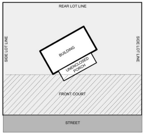
FRONTAGE – See "Lot Frontage."
FUNERAL HOME – An establishment where the dead are prepared for burial or cremation and where wakes and funeral services may be held. A funeral home may include a chapel and facilities for the storage of vehicles used in the business.
GAS STATION – See “Motor Vehicle” definitions.
GOLF COURSE – A tract of land laid out with at least 9 holes for playing the game of golf and improved with fairways, greens, landscaping, and/or hazards. A golf course may include a club house that provides services to golfers and/or members including, but not limited to, the sale and repair of golf equipment and food and beverage service, and accessory buildings and structures necessary for the operation of the course.
GOVERNMENTAL USE – The use or development of a parcel of land or building by a governmental body, agency, or organization or by a quasi-governmental agency or organization carrying out a recognized governmental function.
GROUNDWATER – All the water below the land surface in the zone of saturation or in rock fractures capable of yielding water to a well.
GROUNDWATER RECHARGE – The infiltration of precipitation through surface soil materials into groundwater. Recharge may also occur from surface waters, including lakes, streams and wetlands.
HELIPORT – A facility used for landings and takeoffs by helicopters.
HIGH INTENSITY SOIL SURVEY – See “Soil Survey, High Intensity.”
HISTORIC OR SPECIAL-INTEREST TREE - A tree which has been found by the Tree Warden to be of notable interest because of its age, type, size or historic association.
HOME OCCUPATION – Any occupation, profession, activity or use which is clearly an incidental and secondary use of a residential dwelling unit and which does not alter the exterior of the property or affect the residential character of the neighborhood. It is further defined as follows:
1. HOME OCCUPATION-1 – A home occupation with the following characteristics:
It occupies no more than 500 square feet of floor area.
The principal operator resides on the premises, has not more than 1 other person employed on-site and does not sell on-site any manufactured products prepared by others except for any products that are incidental to the service being provided on site. Services provided electronically and off-site employees who interact electronically with the home occupation are not limited.
The activity is completely enclosed in a primary or accessory structure. There is no indication of such occupation visible on the exterior of the building or on the lot, except permitted signs.
The activity does not produce noise, odor, traffic or other nuisances perceptible at the lot line at a higher level than is usual in a residential neighborhood.
2. HOME OCCUPATION-2 – A home occupation with the following characteristics:
It occupies no more than 1,000 square feet of floor area, with the exception of existing farm structures, which may utilize 100 percent of the floor area.
The principal operator resides on the premises, has not more than 3 other persons employed on-site and does not sell on-site any manufactured products prepared by others except for any products that are incidental to the service being provided on site. Services provided electronically and off-site employees who interact electronically with the home occupation are not limited.
The activity, except for outdoor storage, is completely enclosed in a primary or accessory structure. Outdoor storage of materials or equipment is located outside of any required setback or yard area and shall be at least 10 feet from any lot line and so screened as not to be visible from any public way or shoreline or public park.
The activity does not produce noise, odor, traffic or other nuisances perceptible at the lot line at a higher level than is usual in a residential neighborhood.
HOSPITAL – An institution providing health services, primarily for inpatients, and medical or surgical care of the sick or injured, including as an integral part of the institution such related facilities as laboratories, outpatient departments, training facilities, central service facilities and staff offices.
HOTEL – A commercial operation offering multiple sleeping rooms or suites, each with a private bathroom, for the purpose of providing overnight lodging facilities to the general public for stays of less than 30 consecutive days and usually providing on-site dining facilities, recreational services, function rooms, housekeeping, laundry and related services. Access to guest rooms is provided through interior corridors. See Article XX.
HYDROGEOLOGIST, QUALIFIED – Any person certified in New Hampshire as a Licensed Professional Geologist pursuant to RSA 310-A:125. The Planning Board, at its discretion, may accept as a Qualified Hydrogeologist any person possessing similar credentials from any other state.
IMPERVIOUS SURFACE – A material with low permeability that impedes the natural infiltration of moisture into the ground so that the majority of the precipitation that falls on the surface runs off or is not absorbed into the ground. Common impervious surfaces include, but are not limited to, roofs, concrete or bituminous paving, sidewalks, patios, driveways, roads, parking spaces or lots, and storage areas; compacted gravel including drives and parking areas; and compacted earthen materials, stone, concrete or composite pavers, wood, and swimming pools.
IMPERVIOUS SURFACE AREA – The total area of a site or parcel that is covered by impervious surfaces. The area covered by a deck or similar structure is included in the impervious surface area unless the surface of the deck or structure provides for precipitation to pass through it and reach the ground in a dispersed pattern and the material under the deck or structure is not an impervious surface.
IMPERVIOUS SURFACE RATIO – The impervious surface area of a site or parcel divided by the total area of the site or parcel expressed as a percentage.
INN – A commercial operation within an owner-occupied property containing, in addition to living accommodations for the owner and their family, 4 to 6 guest rooms, without cooking facilities, for the purpose of providing lodging.
JUNKYARD – An area of land used for the exterior storage (i.e., not contained within a completely enclosed structure) of used and discarded materials, including but not limited to wastepaper, rags, metal, building materials, furnishings, machinery, vehicles or parts thereof. "Junkyard" also means any business or any place of storage or deposit which has stored or deposited 2 or more unregistered motor vehicles which are no longer intended or in condition for legal use on the public highways, or used parts of motor vehicles, or old iron, metal, glass, paper, cordage or other waste, or discarded or secondhand material which has been a part or is intended to be a part of any motor vehicle, the sum of which parts shall be equal in bulk to 2 or more motor vehicles.
KENNEL – Any lot or premises on which 4 or more dogs, cats or similar small animals, or a combination thereof, at least 4 months old, which are boarded for compensation or bred for sale. A kennel does not include licensed veterinary medical facilities.
LANDSCAPING – Some combination of planted, living trees, shrubs, hedges, vines, ground cover and flowers suitable for the climate, exposure and site condition. In addition, landscaping may include earth sculpture, cobbles, bark, mulch, edgers, flower tubs, rock and such structures as fountains, pools, artworks, screens, walls, fences or benches, but such objects alone do not define landscaping.
LIGHT MANUFACTURING – See Article XX.
LOT – A legally recorded and defined parcel of land.
LOT AREA – The total area within the boundary lines of a lot. The "lot area" does not include any part of a road right-of-way.
LOT, CORNER – A lot abutting 2 or more intersecting streets where the interior angle of intersection does not exceed 135 degrees. A "corner lot" is considered to be in that block in which the lot fronts. See "Lot Line," Subsection (1)(a).
LOT FRONTAGE – The lot line shared with a street right-of-way. In cases where an existing or proposed lot line is squiggly the frontage is measured along one or more chords from end point to end point of the lot line.
LOT LINE:
1. FRONT LOT LINE – The front property line of a lot is determined as follows:
CORNER LOT or LANDLOCKED LOT – The front property line on a corner lot is as determined by the Zoning Administrator based upon a reasonable consideration of the following: location of the front door, location of the driveway and garage, configuration of other buildings in the vicinity, the lot layout (generally, the shorter lot line is the front lot line as lots tend to be deep and narrow rather than wide and shallow), and other pertinent issues.
2. REAR LOT LINE – The rear property line of a lot is that lot line opposite to the front property line. Where the side property lines of a lot meet in a point, the rear property line is assumed to be a line not less than 10 feet long lying within the lot and parallel to the front property line. In the event that the front property line is a curved line, then the rear property line shall be assumed to be a line not less than 10 feet long lying within the lot and parallel to a line tangent to the front property line at its midpoint.
3. SIDE LOT LINE– The side property lines of a lot are those lot lines connecting the front and rear property lines of a lot.
MAINTENANCE – The replacing or repair of a part or parts of a building or structure which have been made unusable, unsafe, or unsightly, or have been damaged by ordinary wear or tear or by the weather.
MANUFACTURED HOUSING (formerly known as a mobile home) – Any structure, transportable in one or more sections, which, in the traveling mode, is 8 body feet or more in width and 40 body feet or more in length, or when erected on site, is 320 square feet or more, and which is built on a permanent chassis and designed to be used as a dwelling with or without a permanent foundation when connected to required utilities, which include plumbing, heating and electrical heating systems contained therein. Manufactured housing does not include pre-site built, modular or prefabricated housing as defined in RSA 674:31-a. See Article XX.
MARINE SALES AND SERVICE – A business establishment located on a navigable water providing boat sales, rental and storage, marine supplies and equipment, marine engine and hull repairs, construction and outfitting of commercial or pleasure craft, fuel and oil, electricity, freshwater, ice, and other supplies for owners and crew.
MARQUEE - Any hood or awning of permanent construction projecting from the wall or roof of a building or structure above an entrance or extending over a public way.
MASTER PLAN – The Town of Durham Master Plan, and any amendments which may be made thereto, adopted by the Durham Planning Board as a guide to the prudent development and protection of the resources of the community, as laid out in RSA 674:2 Master Plan.
MINING – Commercial extraction of materials from the earth.
MINOR SITE COMMITTEE – A staff committee empowered to review minor site plan applications pursuant to RSA 674:43 III. See Section 175-17 and the Durham Site Plan Regulations.
MISSING MIDDLE HOUSING – Types of housing that are intended to fill the gap in types of residential dwellings between single family houses (on their own lots) on one end and large apartment buildings and complexes on the other end. Missing middle housing includes duplexes, triplexes, triple deckers, quadraplexes, townhouses, rowhouses, single dwelling units not located on their own lot, tiny houses, cottage/bungalow courts, small courtyard apartment buildings, accessory dwelling unit - attached, and apartments over stores.
MIXED USE WITH RESIDENTIAL – A building with both office/retail (See definition) and multi-unit residential uses.
MODULAR HOUSING – See “Pre-site Built Housing.”
MOTEL – A commercial operation offering guest rooms or suites, each with a private bathroom, for the purpose of providing overnight lodging facilities to the general public for compensation, with or without meals, and usually providing housekeeping, laundry and related services. Access to guest rooms is provided directly from a parking lot or from exterior corridors or walkways. See Article XX.
MOTOR VEHICLE GAS STATION – The conventional gas station with gas sold and dispensed at pumps, but with no servicing or repairs performed. This use may include a retail store (small) with up to 5,000 square feet.
MOTOR VEHICLE SALES FACILITY – The use of any building or land area for the display, sale, lease and maintenance of new or used automobiles, trucks, vans, trailers, recreation vehicles, motorcycles, or similar motorized vehicles. This use may include repair facilities.
MOTOR VEHICLE SERVICE FACILITY – A business that provides service, maintenance, and repairs for motor vehicles and engines, including accessory sales.
MUSEUM – A nonprofit institution operated principally for the purpose of preserving, acquiring, and exhibiting objects of historical, cultural, scientific, or artistic interest and which may also engage in the incidental retail sales of items related to its principal purpose.
NEIGHBORHOOD – A contiguous area of a community with: a) defining characteristics such as an integrated network of streets, walkability within the area, similar architecture or period of development, a compatible mix of uses; and b) one or more distinct boundaries such as major roads, railroads, other physical barriers, or natural features like streams, woods, and steep topography.
NONCONFORMING LOT – A lot, the area, dimensions and location of which were lawful prior to the adoption, revision or amendment of this Zoning Ordinance but which fails, by reason of said adoption, revision or amendment, to conform to the present requirements of the zoning district.
NONCONFORMING STRUCTURE – A structure or building, the size, dimensions and location of which were lawful prior to the adoption, revision or amendment of this Zoning Ordinance but which fails, by reason of said adoption, revision or amendment, to conform to the present requirements of the zoning ordinance.
NONCONFORMING USE – A use of a building, structure or parcel of land which was lawful prior to the adoption, revision or amendment of this Zoning Ordinance but which fails, by reason of said adoption, revision or amendment, to conform to the present requirements of the zoning ordinance.
NURSING HOME – A facility licensed by the State of New Hampshire as a nursing home. See “Senior Care Facility.”
OFFICE – A place of business, including for nonprofit and governmental organizations, which includes these types of operations and practices: accounting, architecture, bookkeeping, business services, dentistry, engineering, financial services, general management, general sales, insurance, law, medicine, minor repair services (such as for bicycles, scooters, and lawnmowers but not including automotive engines or comparable components), personal services, professional services, real estate, research and development, telephone sales, and telecommunications. An “office” does not include uses that involve the sale of goods and materials or the physical production of goods and materials, other than those that are incidental to the primary office use, above.
OFFICE/RETAIL – For the land uses Mixed Use with Residential, or any other mixed use that includes office/retail uses, “office/retail” includes retail sales, personal and business services, offices, restaurants, and other comparable commercial uses such as public, institutional, research, and industrial which are allowed in the zoning district. “Office/Retail” for this purpose does not include parking (except where otherwise specifically allowed), storage uses, utility uses where there is minimal flow of people in and out of the building, nor uses that are accessory to the residential use in the building (such as laundry, bicycle storage, and exercise rooms).
OLDER SINGLE-FAMILY RESIDENCE – A single-family residence that has been at its current location since 1950 or earlier. See Reuse of an Older Single-Family Residence in Article XX
VERTICAL OPACITY – The percentage of the area of a fence or wall that is covered by boards, slats, metal links, and other materials, through which one cannot see. Vertical opacity is measured from an elevation drawing.
OPEN SPACE – Forests, fields, wetlands, and other undeveloped lands that contribute to the rural and pastoral character of Durham. Open space may include, but is not limited to, conservation areas, public lands, undeveloped land in private ownership whether protected or not, land being used for passive recreation, and agricultural lands (both cropland and grazing land). See “Common Open Space” as defined in Article XIX.
OR – When used in a series of two or more allowed activities, such as “Dogs may be used for herding, working, or guarding livestock,” means “and/or,” such that any and all of the activities are allowed, individually or in combination. (In general, a reasonable judgment should be made based on the context for the intention of the use of “or.”)
ORDINARY HIGH WATER MARK – The line on the shore, running parallel to the main stem of a river or stream, established by the fluctuations of water and indicated by physical characteristics such as a clear, natural line impressed on the immediate bank, shelving, changes in the character of soil, destruction of terrestrial vegetation, the presence of litter and debris, or other appropriate means that consider the characteristics of the surrounding areas. Where the ordinary high water mark is not easily discernable, the ordinary high water mark may be determined by the NH Department of Environmental Services (NH DES).
OVERLAY DISTRICT - A defined area(s) of the town within which an additional set of standards is applied to all property, independent of the standards established in the underlying base zoning district. Six overlay districts are established as described in Articles XIII-XVIII.
OWNER – The owner of a property is an individual who meets one (or more) of the following descriptions:
A natural person who holds title to the property, either alone or with others.
The grantor or beneficiary of a trust that holds title to the property.
Any shareholder of an S corporation that holds title to the property.
The sole or managing member of a limited liability company that holds title to the property.
Any general or managing partner of a partnership that holds title to the property.
Any family member of a person, within four degrees of kinship, who would qualify as an “owner” under this section.
PARKING GARAGE – A building or portion of a building that includes two or more levels of parking or a mixed-use building with two or more levels where parking is situated on at least one level. A parking garage may be completely or partially enclosed. A parking garage includes a fully enclosed parking area that is situated below ground.
PARKING LOT – An open-air parking area situated on the ground, at finished grade, on a single level and not within a parking garage. A parking lot may incorporate one or more retaining walls to provide an adequate finished grade. A car port and a parking lot covered with solar panels are considered parking lots.
PERFORMANCE GUARANTY – Any security acceptable to the Town as a guaranty that improvements required as part of an application for development will be satisfactorily completed.
PERMEABLE PAVEMENT – See “Porous Pavement/Pavers.”
PERMITTED USE – A use specifically permitted or analogous to those specifically permitted as set forth in the Table of Uses or the zoning district standards.
PERSONAL WIRELESS SERVICE FACILITY – See Article XVIII.
PLANNED UNIT DEVELOPMENT (PUD) - A Planned Unit Development is an innovative planning tool that allows a landowner to propose their own development project with a fair degree of independence from zoning, site plan, and subdivision requirements otherwise applicable to that property. A PUD master plan functions as a special zoning district designation for a particular tract of land in terms of uses, dimensions, and other development standards.
PORKCHOP SUBDIVISION – A porkchop subdivision involves limited subdivision of relatively large lots where there is significant back land but not sufficient street frontage to provide the minimum required frontage for each new lot. See Article XX.
POROUS PAVEMENT/PAVERS – An alternative to conventional asphalt that uses a variety of porous media, often supported by a structural matrix, concrete grid, or modular pavement, which allows water to percolate through to a sub-base for gradual infiltration.
PREFABRICATED HOUSING – See “Presite Built Housing.”
PREMISES – A lot, parcel, tract, site or plot of land together with the buildings and structures thereon.
PRESITE BUILT HOUSING – Any structure designed primarily for residential occupancy which is wholly or in substantial part made, fabricated, formed or assembled in off-site manufacturing facilities in conformance with the United States Department of Housing and Urban Development minimum property standards and local building codes, for installation, or assembly and installation, on the building site. Presite built housing does not include manufactured housing as defined in RSA 674:31. Presite built housing is also called “Modular Housing” or “Prefabricated Housing.” (Presite built housing is not regulated under this Zoning Ordinance.)
PRINCIPAL USE – The primary or predominant use(s) on a property to which all other uses are accessory. There is typically, but not necessarily, one principal use on a property.
PUBLIC UTILITY – A public service corporation, municipal body, or authority providing a specific public service subject to special governmental regulations, for which the recipients pay the provider directly. Utilities may include water supply, sewer service, piped gas, electric supply, telephone, television cable.
PUBLIC WAY – A road, sidewalk, footpath, trail, navigable waterway or right-of-way accessible to the public.
QUALIFIED CONSERVATION ORGANIZATION – As defined in Section 170(h)(3) of the Internal Revenue Code of 1986 or any successor section, and the regulations promulgated thereunder, an organization that is organized and operated primarily for one of the conservation purposes specified in Section 170(h)(4)(A) of that Code. See Article XIX.
RECREATIONAL FACILITY, INDOOR – A building designed and equipped for leisure and recreational activities.
RECREATIONAL FACILITY, OUTDOOR – A site designed and equipped for outdoor sports, leisure and recreational activities. It does not include the use of individual motorized vehicles, all-terrain vehicles, off highway recreational vehicles, motorized rides (except for electronic bicycles), or fire arms.
RECREATIONAL PLAYING FIELDS, OUTDOOR – Noncommercial playing fields for outdoor sports. No structures are included except for necessities like small sheds for maintenance and portable toilets. No lighting, voice amplification equipment or paved parking lots or areas are included.
RECREATIONAL VEHICLE – A vehicle which is built on a single chassis, designed to be self-propelled or permanently towable by a light duty vehicle, and designed primarily for use as temporary living quarters for recreational, camping, travel or seasonal use. (Also called an “RV” or a “Motor Home.”)
REFERENCE LINE – The regulatory limit of a surface water or wetland determined as follows:
For natural fresh water bodies without artificial impoundments, the natural mean high water level as determined by NHDES.
For artificially impounded water bodies with established flowage rights, the limit of the flowage rights and for water bodies without established flowage rights, the waterline at full pond as determined by the elevation of the spillway crest.
For coastal waters, the highest observable tide line, which means a line defining the furthest landward limit of tidal flow, not including storm events, which can be recognized by indicators such as the presence of a strand line of flotsam and debris, the landward margin of salt tolerant vegetation, or a physical barrier that blocks further flow of the tide.
For rivers and streams, the ordinary high water mark.
RELIGIOUS USE/FACILITY – A structure or place in which worship ceremonies, rituals and education pertaining to a particular system of beliefs are held.
RESIDENCE, DUPLEX – A building with 2 dwelling units that are part of the same building.
RESIDENCE, MULTI-UNIT – A building with 3 or more dwelling units.
RESIDENCE, MULTI-UNIT COMPLEX – Two or more buildings of any residential type (single unit, duplex, multi-unit or a combination thereof) with a total of 3 or more dwelling units.
RESIDENCE, SINGLE-FAMILY – A building with a single dwelling unit situated on its own separate lot with no other dwelling units nor nonresidential uses other than those that are accessory to the single-family use (such as accessory dwellings/apartments and home occupations, where allowed.)
RESTAURANT – A commercial establishment open to the general public where food and beverage are prepared and served.
RESTAURANT OR CAFETERIA ACCESSORY TO A NONRESIDENTIAL USE – A food service establishment that primarily serves occupants and other users of a nonresidential use rather than the general public.
RETAIL STORE, MEDIUM – A retail store with 5,000 to 20,000 square feet of gross floor area.
RETAIL STORE, SMALL – A retail store with less than 5,000 square feet of gross floor area.
SAWMILL, TEMPORARY – A portable facility for the sawing, milling, planning, or similar processing of timber or other wood products harvested from the site upon which the temporary sawmill is located. A portable sawmill use shall not include the retail sale of lumber or other wood products on the site. See Article XX.
SCHOOL – See “Educational Facility.”
SCREEN (or SCREENING) – A device or materials used to visually shield one site or one element of a site from a neighboring site or the street. Screening devices may include walls, fences, berms, plantings or a combination thereof. Screening incorporates a high year-round vertical opacity. See “Buffer.”
SELF STORAGE FACILITY – Any self-service facility composed of individual units or lockers rented to the public for storage of personal or business belongings.
SENIOR CARE FACILITY – Housing principally used, designed, or adapted for use by citizens 55 years of age and older who are not capable of living independently and who require assistance in activities of daily living. Residents of a senior care facility receive a package of services to meet their needs. A senior care facility may be contained in a single building or group of buildings and may include assisted living, memory care, and/or nursing home facilities. A life-care community, continuous care retirement community (CCRC) or other retirement community that provides a continuum of care including both independent living units and units for residents who require assistance, is considered to be a senior care facility. See “Nursing Home.”
SENIOR HOUSING – Pursuant to RSA 354-A:15, senior housing refers to a development in which either: a) housing where at least 80% of the units are occupied by at least one person 55 years of age or older; or b) housing where 100% of the occupants are 62 years of age or older. In any development or portion of a development in Durham referred to as “senior housing” 100% of the units include at least one person 55 years of age or older, unless otherwise specified.
SEPTAGE - Material removed from septic tanks, cesspools, holding tanks, or other sewage treatment storage units, but not including sewage sludge from public treatment works and industrial waste and any other sludge. (As defined in RSA 485-A:2.)
SETBACK – The required minimum (except where “maximum” is specified) horizontal distance in feet from a lot line, shoreline, or other referenced line or point to a structure. See Table of Dimensions and Subsection 175-56. D.
SETBACK AREA – The section of the front, side, or rear of a lot corresponding to the area within which structures may not be placed in accordance with front, side, or rear setbacks, respectively. (Also called “Yard.”)
SEWAGE - The water-carried waste products from buildings, public or private, together with such groundwater infiltration and surface water as may be present, as defined in RSA 485-A:2.
SHALL – Where the term “shall” is used, the person or party is required to do what is referred to.
SHORE FRONTAGE – The width of a lot bordering on the following waterbodies, measured in a straight line between the intersections of the lot lines with the reference line (See definition): Great Bay, Little Bay, the Oyster River, the Lamprey River, Johnson Creek, Bunker Creek, Folletts Brook, and the tidal sections of their tributary streams.
SHORT-TERM RENTAL – An accessory use to an owner-occupied single-family residence containing, in addition to living accommodations for the owner and the owner’s family, not more than 3 sleeping rooms, for the purpose of providing to the general public, for compensation, lodging, with or without breakfast, for less than thirty consecutive days. A short-term rental is not considered a home occupation. See Article XX.
SIGN – See Article XXIII.
SITE PLAN – A plan of a lot, tract or parcel of land showing the specific location of all existing and proposed features, such as buildings, other structures, driveways, parking, landscaping, easements, utilities, and drainage structures.
SLOPE – A measurement of the deviation of a ground surface from horizontal measured in percent (rise over run) or in degrees.
SLUDGE - The solid or semisolid material produced by water and wastewater treatment processes, but not including domestic septage. However, sludge which is disposed of at solid waste facilities as permitted by the New Hampshire Division of Environmental Services is considered solid waste, as defined in RSA 485-A:2.
SOIL, POORLY DRAINED – Any soil type having a soil drainage classification of “poorly drained” when classified in accordance with the most recent definitions, standards, and procedures of the Society of Soil Scientists of Northern New England.
SOIL, SOMEWHAT POORLY DRAINED – Any soil type having a soil drainage classification of “somewhat poorly drained” when classified in accordance with the most recent definitions, standards, and procedures of the Society of Soil Scientists of Northern New England.
SOIL, VERY POORLY DRAINED – Any soil type having a soil drainage classification of “very poorly drained” when classified in accordance with the most recent definitions, standards, and procedures of the Society of Soil Scientists of Northern New England.
SOIL SURVEY, HIGH INTENSITY – A soils map and related materials prepared and certified by a New Hampshire Certified Soil Scientist in accordance with the Society of Soil Scientists of Northern New England (SSSNNE) Special Publication - No.1, High Intensity Soil Maps for New Hampshire (www.sssnne.org), as amended.
SOLAR ENERGY SYSTEMS – Specific definitions pertinent to solar energy systems follow.
Building-Mounted Solar Energy System − A solar energy system attached to and completely supported by a building that does not extend more than 5 feet beyond the building footprint. The system may include necessary accessory equipment that is ground mounted.
Freestanding Solar Energy System − A ground-mounted solar energy system, including a stationary or tracking system (either single axis or dual axis). A Solar Photovoltaic (PV) Parking Canopy is not a Freestanding Solar Energy System.
Group Net Metering Host, Small – A Solar Photovoltaic (PV) System less than or equal to 100 KW that shares energy and Net Metering benefits with members of a registered group per N.H. PUC 909.
Group Net Metering Host, Large – A Solar Photovoltaic (PV) System greater than 100 KW and less than 5 MW that shares energy and Net Metering benefits with members of a registered group per N.H. PUC 909.
Multi-unit Residential or Nonresidential Solar Energy System − An accessory use designed to provide solar energy for the principal and accessory uses of Multi-Unit Residential, mixed Use with Residential and other Nonresidential uses.
Name Plate Rating - The maximum sustained electric power-generating capacity of the Solar Energy System.
Solar Energy − Radiant energy emitted by the sun.
Single-Family or Duplex Residential Solar Energy System – A Solar Energy System that is an accessory use designed to generate energy for use at the property. A Single-Family or Duplex Residential Solar System may also be a Small Group Net Metering Host up to the size limits specified in 175-109.N.4.
Solar Energy System − A structure and the related components used to transform solar energy into electricity (through a solar photovoltaic system) or heat (through a solar thermal system).
Solar Photovoltaic (PV) Parking Canopy – An elevated structure that supports solar panels over a parking area. A solar photovoltaic parking canopy is not a carport. The structure is not used with single-family and duplex uses, nor is it considered parking garage.
Solar Photovoltaic (PV) System − A solar collection, mounting, inversion, storage and distribution system that converts sunlight into electricity.
Solar Thermal System − A solar collection system that directly heats a heat-transfer medium.
Utility-Scale Solar Energy System, Small - A limited electrical energy producer as defined in RSA 362-A:1 with a solar energy generating capacity equal to or less than 100 kW that generates energy for use off site by customers. A Small Utility-Scale Solar Energy System does not function as a Small Group Net Metering Host.
Utility-Scale Solar Energy System, Large – A limited electrical energy producer as defined in RSA 362-A:1 with a solar energy generating capacity of greater than 100 kW and less than 5 MW that generates energy for use off site by customers. A Large Utility-Scale Solar Energy System does not function as a Large Group Metering Host
SOLID WASTE – Any discarded or abandoned material, including refuse, putrescible material, septage or sludge, as defined by New Hampshire Solid Waste Rule He-P 1901.03. Solid waste includes solid, liquid, semisolid or gaseous waste material resulting from residential, industrial, commercial, mining and agricultural operations.
SPECIAL EXCEPTION – See Article VIII.
STEEP SLOPE – A slope exceeding 15% where there is a change in elevation of at least 4 feet. See “Slope.”
STORY - The complete horizontal division of a building, situated at or above ground level, comprising the usable space or room(s) on one level. Each such division is considered 1 full story, except for the top level when it is under a sloped roof, which is considered a ½ story. For the purpose of determining the total number of permitted stories, a sloped roof that does not contain usable space (other than crawl-type storage space) is not considered a ½ story. For the purposes of this ordinance, a lower level is considered to be a story if the front exterior wall of the lower floor level rises more than 2 feet above the finished grade. Cupolas with areas of 100 square feet or less do not count as a story.
STREET, ARTERIAL – A high-order street designed to provide access to the regional transportation system and move traffic through or around the town or from one general area of the town to another. "Arterial streets" include Main Street west of Mast Road, U.S. Route 4, Route 108, Route 155A and Route 155.
STREET, COLLECTOR – A middle-order street which is functionally classified as a “collector” and collects local traffic from neighborhoods and moves it to an adjacent neighborhood or transfers the traffic to the arterial system. Bagdad Road, Bay Road, Bennett Road, Durham Point Road, Emerson Road, Madbury Road, Main Street (from Newmarket Road to Mast Road), Mill Road, and Packers Falls Road are considered collector streets.
STREET LINE – The street right of way line/lot boundary line separating the street right of way from the lot.
STREET, MINOR – A low-order local street. If a particular street is not classified as an arterial or collector street, it is considered a minor street.
STREET, PRIVATE – A private right-of-way for vehicles which provides a principal means of access to 2 or more lots and is subject to an easement for ingress and egress running with the land to the benefit of all lots having frontage thereon.
STREET, PUBLIC – A dedicated public right-of-way for vehicles which affords a principal means of access to abutting properties.
STRUCTURE - That which is built or constructed with a fixed location on the ground or attached to something having a fixed location on the ground. See Section 175-56.E.
SUBDIVISION – The division or re-subdivision of a lot into 2 or more lots, a lot line adjustment, the creation of a condominium, or the conversion of land or a building(s) to a condominium form of ownership.
THEATER – A building or part of a building whose principal use is showing motion pictures or providing live performances.
TOXIC OR HAZARDOUS MATERIAL – Any substance or mixture of such physical, chemical or infectious characteristics as to pose a significant actual or potential hazard to water supplies or other hazard to human health. "Toxic or hazardous materials" include, but are not limited to: volatile organic chemicals; petroleum products; heavy metals; radioactive materials; infectious materials or wastes; acids; alkalis; products such as pesticides, herbicides, solvents and thinners; or such other substances as defined in New Hampshire Department of Environmental Services Rules Section Env-Wm-400, in New Hampshire Solid Waste Rule Env-Wm 100 and in the Code of Federal Regulations 40 CFR 261, as amended. The more-restrictive rules shall apply in all cases.
The following commercial activities are presumed to use toxic or hazardous materials and/or to generate wastes containing toxic or hazardous materials, unless and except to the extent that anyone engaging in such an activity can demonstrate the contrary to the satisfaction of the Planning Board. In all cases the burden of proof shall rest with the applicant:
Airplane, boat and motor vehicle service and repair, including gasoline stations.
Chemical and biological laboratory operations.
Dry cleaning.
Electronic circuit manufacturing.
Metal plating, finishing and polishing.
Motor and machinery service and assembly.
Painting, wood preserving and furniture stripping.
Pesticide and herbicide application.
Photographic processing.
Printing.
Any other commercial or industrial activity which, in the judgment of the Planning Board, typically uses toxic or hazardous materials or produces wastes containing toxic or hazardous materials.
Storage and/or distribution of chemicals or any other hazardous materials used in any of the above activities.
TREATED SOILS – Soils decontaminated by a treatment process and certified for distribution and use as soil under NH Env-Wm 3203.11, having originally been contaminated with liquids or materials not regulated by the State of New Hampshire as hazardous waste defined under NH Env-Wm 2603.01.
TREE WARDEN - The person designated by the Town Administrator to assist the Town boards, residents, and other Town staff in any appropriate matters related to the conservation, protection, and enhancement of native and naturalized trees and other vegetation located on both public and private property in Durham, in furtherance of the goals of this Zoning Ordinance and other Town ordinances and regulations, and pursuant to RSA 231:139 (II).
UNSUITABLE AREA – The area of a parcel that must be subtracted from the gross area of the parcel to determine the usable area of the parcel. See “Usable Area.”
USE – The specific purpose(s) for which a building or lot, or a portion thereof, is arranged, intended, designed, occupied or maintained.
USABLE AREA – The area of any conservation subdivision, that is suitable, in its natural state, for development or intensive use and, therefore, can be used in determining the allowed density of development. The usable area of a parcel of land is determined in accordance with the provisions of Section 175-56(E).
VARIANCE – A deviation from the terms of this chapter, allowed when the Zoning Board of Adjustment determines that the required criteria are met. See Article VIII.
VETERINARY CLINIC – See “Animal Care.”
WAREHOUSE – A building for the storage of commercial goods and materials.
WETLAND – See Article XIII and Article XIV.
WORKFORCE HOUSING CONSERVATION SUBDIVISION – A conservation subdivision that provides housing for rent and/or for sale which meets the standards for Workforce Housing in accordance with RSA 58-61. See Article XIX.
YARD – See “Setback Area.”
Article IIIAdministration and Enforcement
§ 175-8Administrative Officer
Authority to administer this Zoning Ordinance is hereby vested in the Town Administrator, who is duly appointed by the Town Council. The Town Administrator shall have the authority to appoint a Zoning Administrator or duly qualified designee, who shall have the authority to administer, interpret, and enforce the provisions of this chapter. In the performance of these duties, the Zoning Administrator may request entry to any building, structure or premises, or any part thereof, at any and all reasonable times for the purpose of performing his or her official duties.
§ 175-9Zoning Administrator
The Zoning Administrator, his or her assistant or designee shall:
Enforce any and all provisions of this chapter.
Keep complete, accurate and secure records.
Accept applications and ensure their appropriateness and completeness.
Accept and remit fees as established in the adopted administrative procedures.
Update these regulations and the Official Zoning Map as directed by the Town Council.
Provide for the accuracy and security of the Official Zoning Map.
Undertake any other administrative function appropriate to the office of the Zoning Administrator.
Report to the Town Planning Board any recommendations for changes and improvements in these regulations and the procedures therein.
Issue any permit granted by the Planning Board or ordered by the Board of Adjustment and make periodic inspections to verify that all conditions of such granted permit are complied with by the applicant or his or her agent.
Receive and investigate allegations of noncompliance or violation of these regulations, report findings to the Town Council and file a complaint where such allegations are based in apparent fact.
Refer any matters under appeal to the Zoning Board of Adjustment for its action.
Make recommendations to the Planning Board in connection with any conditional use permit or to the Board of Adjustment in connection with any application for variance or appeal and recommend such conditions as may be necessary to fully carry out the provisions and intent of this Zoning Ordinance.
The Zoning Administrator shall not:
Make any changes in the uses categorically permitted in any zoning classification or zoning district, or make any changes in the terms of this Zoning Ordinance, or make any changes in the terms, classifications or their boundaries on the Official Zoning Map.
Issue any conditional use permit or variance without the specific direction to do so from the authorizing body.
The Zoning Administrator, or their designee, may request that any landowner or association certify, under oath, compliance with any zoning requirement, including but not limited to age restrictions, rental restrictions, or occupancy restrictions, if, in their discretion, there is a reasonable basis to believe that there is a zoning violation on the property. Should the owner refuse to provide such certification, the Zoning Administrator may seek an administrative search warrant to confirm compliance with the town’s zoning ordinance.
§ 175-10Violations and Penalties, Methods of Corrections
Any person, partnership, association, company, corporation or individual who violates, disobeys, omits, neglects, or refuses to comply with the provisions of this chapter shall be deemed guilty of a misdemeanor offense and, upon conviction thereof by a court of competent jurisdiction, shall be punished by a civil fine as set forth in RSA 676:17 for each day such violation continues.
A violation or suspected violation may be brought to the attention of the Zoning Administrator by any individual who suspects that such violation has or may be occurring. The Zoning Administrator shall conduct an investigation into the alleged violation. In the event that efforts fail to result in an abatement of the violation, the Zoning Administrator shall notify the Town Administrator and file a complaint with the Town Attorney. The Town Attorney shall take appropriate legal action to address the complaint and the matter shall come before a court of competent jurisdiction for resolution.
Every violation of these regulations shall be a separate and distinct offense, and in the case of a continuing violation, each day's continuance shall be deemed a separate and distinct offense.
Article IVInterpretation, Amendments, and Legal Provisions
§ 175-11Scope and Interpretation
In interpreting and applying the provisions of this chapter, affected parties shall be held to be the minimum requirements for the promotion of the health, safety, convenience and general welfare of the Town of Durham and its residents. Where a provision of this chapter differs from that prescribed by any other applicable statute, ordinance or regulation, that provision which imposes the greater restriction or the higher standard shall govern. Any use not specifically permitted or permitted by conditional use permit is prohibited.
§ 175-12Administrative Appeals
Any person who believes that the Zoning Administrator has made an error in the interpretation or application of the provisions of this Ordinance, may appeal such determination to the Zoning Board of Adjustment as an administrative appeal under the provisions of Section 175-19. If the Board finds that the Zoning Administrator erred in his or her interpretation of the Ordinance, it shall modify or reverse the decision accordingly.
§ 175-13Severability
The provisions of this chapter are severable. If a court finds that any section or provision of this ordinance is invalid, this finding shall not invalidate any other section or provision of this chapter and those other sections shall remain in force without further action by the Town Council.
§ 175-14Amendment Procedure
Amendments to the Zoning Ordinance including the Official Zoning Map may be initiated by the Planning Board, Town Council, or citizens in accordance with the following procedures:
Amendments Initiated by the Planning Board. The Planning Board may, upon its own initiative, from time to time, consider amendments to the Zoning Ordinance, including its overlay districts and the zoning map, and submit recommendations thereon to the Town Council. The referral shall be made in writing by the chair of the Planning Board. Such amendments shall be developed pursuant to the notice and public hearing requirements contained in Subsection D below.
Amendments Initiated by the Town Council. The Town Council may, upon its own initiative, from time to time, consider changes to the Zoning Ordinance, including its overlay districts and the zoning map. All such Council-initiated changes shall be referred to the Planning Board for its review and study. The referral shall be made in writing by the Town Administrator. The Planning Board shall, after following the public notice and hearing requirements contained in Subsection D below, submit a recommendation regarding the changes to the Town Council members within 60 days of their referral. (the date of the letter from the Town Administrator). The Town Council may grant extensions to this timeframe at its discretion.
Amendments Initiated by Citizens. Citizens submitting amendments to the Zoning Ordinance, including its overlay districts, shall forward their proposed changes to the Planning Board for its consideration. Such submission shall be by typed petition signed by not fewer than 50 properly registered voters of the Town of Durham, and shall set out the language of the proposed amendment or the proposed change to the Official Zoning Map. The Planning Board shall have the request placed on the agenda for its next regularly scheduled meeting. It shall, after following the notice and public hearing requirements contained in Subsection D below, make its recommendation concerning such request to the Town Council within 60 days of the date of the Planning Board's initial consideration. A 30-day extension of the above time limit may be granted by the Town Council.
Public Notice and Hearing Requirements.
Notice. Notice shall be given for the time and place of the public hearing at least 10 days before the hearing. The notice required under this section shall not include the day notice is posted or published or the day of the public hearing. Notice of the public hearing shall be posted prominently on the Town’s website and in at least 2 other public places.
Text of Ordinance. The full text of the proposed amendment to the Zoning Ordinance need not be included in the notice if an adequate statement describing the proposal and designating a place where the proposal is on file for public inspection is stated in the notice.
Ordinance Form. Any amendment to the aforementioned ordinances approved by the Planning Board or submitted through it pursuant to Subsection G below shall be submitted to the Town Administrator, who shall be responsible for putting the amendment into proper ordinance form beginning with the words "The Town of Durham ordains..." Whenever practical, the Town Administrator shall set out in full the ordinance sections or subsections to be repealed or amended and shall indicate the material to be omitted by enclosing it in brackets or by strikeout type and shall indicate new material by underscoring it or by typing it in italics. In every case, the recommendation of the Planning Board shall follow immediately at the end of the proposed amendment.
Action by Town Council.
Agenda. The proposed amendment shall be placed on the agenda of the Council at the next regularly scheduled Council meeting for first reading.
First Reading. If the Council votes not to pass at the first reading, the proposed amendment dies. If the Council votes to pass the amendment to second reading, it shall be scheduled for a public hearing before the Council. The Council may, however, refer an amendment initiated by petition that has not passed at the first reading to the Planning Board to be revised and resubmitted to the Town Council for reconsideration. Such reconsideration shall be considered to be the first reading of the amendment.
Notice and Public Hearing Requirements. Prior to final Council action, the notice provisions contained in Subsection D above shall be followed.
Minor Revisions. After the public hearing, the Council may make minor changes to the proposed amendment, so long as the proposed amendment remains substantially the same as that which was advertised for the public hearing.
Second Reading. Following the second reading and public hearing, the Council shall vote on the proposed amendment.
Majority Vote Required. Any proposed amendment shall require a majority affirmative vote of Council members present in order to pass.
Recording of Amendment. If passed by the Council, the ordinance amendment shall be recorded, authenticated, indexed and printed in accordance with the provisions of the municipal charter.
Protest Process. Pursuant to RSA 675:5, concerned property owners may protest proposed amendments to the Zoning Ordinance.
Requirements for Council Consideration of Protest Petition(s).
In order to have any protest considered:
The owners signing the petition shall identify themselves on the petition by name and address and by address of the property involved or by lot and map number or by whatever other means is used within the town to identify the land in question so that the Durham Town Council may identify such others as interested and affected parties.
The signed protest petition shall be submitted to the Durham Town Council at least 10 days prior to the next Town Council meeting; provided, however, that each protest petition shall apply to that petition only. The Chair of the Durham Town Council shall announce at the opening of the Council meeting that a protest petition has been received.
Any such amendment or repeal developed pursuant to this subsection shall not become effective except by the favorable vote of 2/3 of all Council members present at its second reading. (See Subsection F above.)
Article VPlanning Board
§ 175-15Planning Board
There shall be a Planning Board consisting of 7 members and not more than 5 alternate members as provided by state statute in accordance with Sec.11.1.A of the Town Charter.
During the period of his or her service on the Planning Board, a member may not appear before the Planning Board as a paid representative of or paid consultant to an applicant before the Board.
The Town Administrator shall meet with the Planning Board as needed to provide the Board with the information and guidance necessary for the Board to carry out its duties including those specified in Section 175-16 and fulfill the purposes set out in Section 175-3.
§ 175-16Powers and Duties
The Planning Board shall have all the powers granted to, and the duties conferred upon, planning boards by state law, including but not limited to the following:
The Planning Board shall prepare and amend, from time to time, a Master Plan to guide development of the municipality in accordance with RSA 674:1.
The Planning Board may initiate changes in the Zoning Ordinance to ensure that the Town’s regulations are consistent with the adopted Master Plan.
The Planning Board shall review and make recommendations to the Town Council on proposed amendments to the Zoning Ordinance.
The Planning Board shall develop, adopt, and periodically review and amend subdivision regulations, site plan review regulations, road standards, and other land use regulations authorized by state law or local ordinances.
The Planning Board shall review and approve or disapprove proposals for subdivisions.
The Planning Board shall review and approve or disapprove site plans for the development or change or expansion of use of tracts for nonresidential uses or multi-unit residences whether or not such development includes a subdivision or re-subdivision of the site, and as provided for in RSA 674:43.
The Planning Board shall review and approve or disapprove requests for Conditional Uses.
§ 175-17Delegation of Site Review Authority
The Planning Board is empowered to delegate to a Minor Site Committee, its site review powers for minor site plan reviews of permitted uses pursuant to RSA 674:43 III. The Minor Site Committee shall, at a minimum, consist of the Code Enforcement Officer/Zoning Administrator, and the Town Planner. The membership of the Minor Site Committee may expand at the discretion of the Code Enforcement Officer/Zoning Administrator and the Town Planner to include staff representatives from other town departments, including, but not limited to, the Public Works, Police, Fire and Economic Development Departments. The Minor Site Committee shall ensure compliance with the provisions of the Town of Durham Site Plan Review Regulations. The Committee shall have the power to grant waivers under Part I, Article 5 of the Site Plan Review Regulations. The Minor Site Committee shall approve, deny, or make a recommendation to the Planning Board on site plans reviewed by it. For each site plan reviewed by the Minor Site Committee, the Planning Board shall be provided, at its next regularly scheduled meeting, a written report of the Minor Site Committee’s decisions. Decisions rendered by this committee may be appealed to the full Planning Board, provided that a notice of appeal is filed within thirty (30) days of the committee's decision. The Planning Board shall hold a public hearing on the appeal. The review by the Planning Board shall be based upon the materials submitted to the Minor Site Committee, the record of the committee action, and testimony at the public hearing. The Planning Board may affirm or change the decision of the committee. All provisions of RSA 676:4 shall apply to actions of the Minor Site Committee.
Article VIZoning Board of Adjustment
§ 175-18Appointment
Appointment. There shall be a Zoning Board of Adjustment appointed by the Town Council, consisting of 5 members in accordance with Sec. 11.2. of the Town Charter and state law each serving a 3-year term and 3 alternates each serving a 3-year term. Such terms shall be staggered. The Town Council shall fill any vacancy for the period of the unexpired term.
Disqualification of Board Member. No member of the Zoning Board of Adjustment shall sit upon the hearing on any question which the Board is to decide in a judicial capacity who would be disqualified from any case, except exemption from service and knowledge of the facts involved gained in the performance of his or her official duties, to act as juror upon the same matter in any action at law.
§ 175-19Powers and Duties
The Zoning Board of Adjustment is hereby authorized and empowered to adopt such rules of organization and procedure as are necessary for the efficient administration and enforcement of this chapter. In addition, the Zoning Board of Adjustment shall have the following powers pursuant to RSA 673:1 and 674:33:
Appeals. To hear and decide appeals where it is alleged that there is error in any order, requirement, decision or determination made by an administrative official in the enforcement of this chapter.
Variances. To authorize, upon appeal, in specific cases, such variance from the terms of this chapter as will not be contrary to the public interest where, owing to special conditions, a literal enforcement of the provisions of this chapter will result in unnecessary hardship and so that the spirit of the chapter shall be observed and substantial justice done.
Special Exceptions. The Board shall hear and decide requests for special exceptions only when the granting of a special exception is specifically provided for in this chapter. No other special exceptions shall be granted. The request for the special exception and the Board’s action on the request shall reference the specific section whereby the granting of the special exception is provided for in this chapter. Appropriate conditions may be placed on special exception approvals when necessary to meet the standards of this chapter.
Equitable Waivers. To hear and decide requests for equitable waivers of dimensional requirements as provided for in RSA 674:33-a.
Appeals under the Building Code. The Zoning Board of Adjustment is hereby authorized and empowered to act as the Building Code Board of Appeals pursuant to RSA 673:1. The Building Code Board of Appeals shall hear and decide appeals of orders, decisions, or determinations made by the building official or fire official relative to the application and interpretation of the state building code or state fire code as defined in RSA 155-A:1. An application for appeal shall be based on a claim that the true intent of the code or the rules adopted thereunder have been incorrectly interpreted, the provisions of the code do not fully apply, or an equally good or better form of construction is proposed. The board shall have no authority to waive requirements of the state building code or the state fire code. (RSA 674:34)
In exercising the above-mentioned powers, the Board may, in conformity with the provisions hereof, reverse or affirm, wholly or partly, or may modify the order, requirements, decision or determination appealed from and may make such order or decision as ought to be made and to that end shall have all the powers of the officer from whom the appeal is taken.
The concurring vote of 3 voting members of the Board shall be necessary take action on any matter upon which it is required to pass under this chapter or to effect any variation in this chapter.
§ 175-20Meetings
A Chair and clerk shall be appointed. The Chair or, in his or her absence, the Acting Chair may administer oaths and compel the attendance of witnesses.
Meetings of the Board shall be held at the call of the Chair and at such times as the Board may determine.
All meetings of the Board shall be open to the public. The Board shall keep minutes of its proceedings in accordance with RSA 91-A as amended, showing the vote of each member upon each question or, if absent or failing to vote, indicating such fact, and shall keep records of its examinations and other official actions, all of which shall be filed in the Town Office and shall be a public record.
Article VIIConditional Use Permits
§ 175-21Conditional Use Permits
The purpose and intent of a Conditional Use permit is to allow certain uses that are not normally permitted under conventional zoning provisions. Specifically authorized conditional uses appear in Section 175-53, Table of Land Uses. A Conditional Use shall be approved if the application is found to be in compliance with the approval criteria in Section 175-23. Further Conditions may be placed on the Conditional Use Permit by the Planning Board to ensure that the Conditional Use will have a positive economic, fiscal, public safety, environmental, aesthetic, and social impact on the town. The Planning Board shall make findings of fact, based on the evidence presented by the applicant, Town staff, and the public, respecting whether the Conditional Use is or is not in compliance with the approval criteria of Section 175-23
No structure, building or land requiring a conditional use permit shall be used, constructed, altered or expanded unless a conditional use permit specifically required by this chapter has been authorized by the Planning Board and issued by the Town Planner.
Any use that was lawfully established prior to the adoption, extension or application of this chapter and is now permitted by this chapter subject to a conditional use permit may continue in the same manner and to the same extent as conducted prior to said adoption or extension of this chapter. A conditional use permit shall be secured from the Planning Board before the use or structure or building in which said use is conducted may be altered, added to, enlarged, expanded or moved from one location to another on the lot on which said use is located.
Structures or buildings devoted to any use permitted under the terms of this chapter subject to the securing of a conditional use permit, may not be altered, added to, enlarged, expanded or moved from one location to another on the lot without securing a new conditional use permit.
§ 175-22Procedures
Application.
Application for a conditional use permit may be made by the owner of the affected property, or his or her designated agent, on a form obtainable from the Town Planner.
The completed application and fee as set by the Town Council shall be submitted to the Town Planner or his or her designee. Said fee is nonrefundable.
Procedure for Consideration.
After receipt by the Town Planner or his or her designee, the completed application shall be transmitted to the Planning Board staff for their review and evaluation.
The planning staff shall set a public hearing date and post a notice advertising the public hearing before the Planning Board on the Town website. Public notice shall be made at least 10 calendar days prior to the meeting of the Planning Board at which the application is to be considered.
The planning staff shall also mail written notice, by verified mail, to all abutting and adjacent property owners within 300 feet of the subject property and a sign measuring 2 x 3 feet shall be placed on the property by the applicant not less than 10 calendar days prior to the time of the public hearing by the Planning Board. The sign shall remain on the property until the conclusion of the public hearing. This sign shall be visible from the most heavily traveled street right-of-way adjacent to the property. The sign shall state the date of the public hearing, the time, the location and the action to be considered. (Where the subject property abuts a public right-of-way, the 300-foot measurement shall be in addition to the right-of-way along the abutting side.)
Any written comment shall be specific when maintaining that the granting of the conditional use permit would adversely or injuriously affect the writer's personal and legal interests.
The Planning Board shall consider the application at its next regular meeting following the public notice process.
Where development approval for a conditional use includes subdivision or site plan approval by the Planning Board, the application and review procedure for a conditional use permit shall be made concurrently and in accordance with the procedures specified in the Subdivision Regulations or Site Plan Regulations as applicable to the particular development.
Approval of Application and Granting of Conditional Use Permit. At least 5 members must vote in favor of the issuance of a Conditional Use Permit for an application to be approved. Upon rendering a decision to grant a conditional use permit with conditions of approval that must be adhered to by the applicant, the Town Planner shall send a notice to the applicant of the board’s decision, which shall include all conditions of approval. The application and all subsequent information, correspondence, evaluations, recommendations and decisions shall then be placed on permanent file in the office of the Town Planner. The Conditional Use Permit Findings of Fact and Conditions of Approval shall be recorded at the Strafford County Registry of Deeds.
Revocation. In the event of a violation of any of the provisions of these regulations or amendments thereto or in the event of a failure to comply with any prescribed condition of approval or stipulations placed upon such approval, the Zoning Administrator, in coordination with the Town Planner, shall suspend any conditional use permit immediately, shall notify the Planning Board and shall set a date for a hearing to determine if such suspensions shall be lifted or if the conditional use permit shall be revoked. The Planning Board shall be the hearing body. In the case of a revocation of a conditional use permit, the determination of the Planning Board shall be final, unless recourse is sought in a court of competent jurisdiction.
Termination and Transferability. Once granted, a conditional use permit, with its terms and conditions, shall:
Terminate 12 months from the date of authorization if the authorized use has not begun:
Unless otherwise spelled out in the conditions of approval; or
Unless the applicant can demonstrate good reason(s) at a public hearing before the Planning Board why the permit should be extended.
Terminate after 12 consecutive months of nonuse.
Denial of application. In the event that an application is denied by the Planning Board, no resubmittal of an application for a conditional use permit for the same or similar use may be made for 1 year from the date of said denial, unless sufficient new evidence or conditions are offered to the Zoning Administrator, in consultation with the Town Planner, to demonstrate that the circumstances have altered and that further consideration of the application is warranted. In such an event, the resubmitted application shall follow the same procedures as the original and shall be treated as a new application.
§ 175-23Approval Criteria
Planning Board Decision Based on Findings. Every decision of the Planning Board pertaining to the granting, denial or amendment of a request for a conditional use permit shall be based upon findings of fact and conditions of approval. The findings of fact and conditions of approval shall be supported in the records of its proceedings. The criteria enumerated in Subsection C are required to be met in any matter upon which the Planning Board is required to pass under these regulations. A mere finding or recitation of the enumerated conditions unaccompanied by findings of specific fact shall be deemed not to be in compliance with these regulations.
Burden on applicant. The applicant shall bear the burden of persuasion, through the introduction of sufficient evidence, through testimony, or otherwise, that the development, if completed as proposed, will comply with this Article and will satisfy the specific requirements for the use contained in the ordinance.
Criteria Required for Consideration of a Conditional Use Permit. A conditional use permit shall be granted only if the Planning Board determines that the proposal conforms to all of the following conditional use permit criteria (except for specific criteria that are deemed by the Planning Board to be not pertinent to the application):
Site suitability: The site is suitable for the proposed use. This includes:
Adequate vehicular and pedestrian access for the intended use.
The absence of environmental constraints (floodplain, steep slope, etc.) or development of a plan to substantially mitigate the impacts of those constraints.
External impacts: The external impacts of the proposed use on abutting properties and the neighborhood shall be no greater than the impacts of adjacent existing uses or other uses permitted in the zone. This shall include, but not be limited to, traffic, noise, odors, vibrations, dust, fumes, hours of operation, and exterior lighting and glare. In addition, the location, nature, design, and height of the structure and its appurtenances, its scale with reference to its surroundings, and the nature and intensity of the use, shall not have an adverse effect on the surrounding environment nor discourage the appropriate and orderly development and use of land and buildings in the neighborhood.
Character of the site development: The proposed layout and design of the site shall not be incompatible with the established character of the neighborhood and shall mitigate any external impacts of the use on the neighborhood. This shall include, but not be limited to, the relationship of the building to the street, the amount, location, and screening of off-street parking, the treatment of yards and setbacks, the buffering of adjacent properties, and provisions for vehicular and pedestrian access to and within the site.
Character of the buildings and structures: The design of any new buildings or structures and the modification of existing buildings or structures on the site shall not be incompatible with the established character of the neighborhood. This shall include, but not be limited to, the scale, height, and massing of the building or structure, the roof line, the architectural treatment of the front or street elevation, the location of the principal entrance, and the material and colors proposed to be used.
Preservation of natural, cultural, historic, and scenic resources: The proposed use of the site, including all related development activities, shall preserve identified natural, cultural, historic, and scenic resources on the site and shall not degrade such identified resources on abutting properties. This shall include, but not be limited to, identified wetlands, floodplains, significant wildlife habitat, stonewalls, mature tree lines, cemeteries, graveyards, designated historic buildings or sites, scenic views, and viewsheds.
Impact on property values: The proposed use will not cause or contribute to a significant decline in property values of adjacent properties.
Availability of Public Services & Facilities: Adequate and lawful facilities or arrangements for sewage disposal, solid waste disposal, water supply, utilities, drainage, and other necessary public or private services, are approved or assured, to the end that the use will be capable of proper operation. In addition, it must be determined that these services will not cause excessive demand on municipal services, including, but not limited to, water, sewer, waste disposal, police protection, fire protection, and schools.
Fiscal impacts: The proposed use will not have a negative fiscal impact on the Town unless the Planning Board determines that there are other positive community impacts that off-set the negative fiscal aspects of the proposed use. The Planning Board’s decision shall be based upon an analysis of the fiscal impact of the project on the town. The Planning Board may commission, at the applicant's expense, an independent analysis of the fiscal impact of the project on the town.
Conditions of Approval. Conditional Use Permit approvals shall be subject to appropriate conditions where such conditions are shown to be necessary to further the objectives of this ordinance and the Master Plan, or which would otherwise allow the general conditions of this article to be satisfied. Conditions of approval shall be stated in writing in the issuance of a permit. The conditions shall, if applicable, include, but are not limited to, the following:
Front, side, and rear setbacks in excess of the minimum requirements of this Ordinance.
Screening of the premises from the street or adjacent property in excess of any minimum requirements of this Ordinance.
Landscaping in excess of any minimum requirements of this Ordinance.
Modification of the exterior features of buildings or other structures.
Limitations on the size of buildings and other structures more stringent than the minimum or maximum requirements of this Ordinance.
Footprint or lot coverage less than the allowed maximum of this Ordinance.
Limitations on the number of occupants and methods and times of operation.
Grading of the premises for proper drainage.
Regulation of design of access drives, sidewalks, crosswalks, and other traffic features.
Off-street parking and loading spaces in excess of, or less than, the minimum requirements of this Ordinance.
Other performance standards as appropriate.
§ 175-24Appeals
Any persons aggrieved by a Planning Board decision on a Conditional Use Permit may appeal that decision to the Superior Court, as provided for in RSA 677:15. A Planning Board decision on the issuance of a Conditional Use Permit cannot be appealed to the Zoning Board of Adjustment. (RSA 676:5 III)
Article VIIIVariances and Special Exceptions
§ 175-25Variances
Accommodation of Persons with a Recognized Physical Disability. The Zoning Board of Adjustment may grant a variance from the dimensional standards of this ordinance without finding a hardship when reasonable accommodations are necessary to allow a person or persons with a recognized physical disability to reside in or regularly use the premises, provided that:
Any variance granted under this paragraph shall be in harmony with the general purpose and intent of the zoning ordinance.
Variances from Flood Hazard Overlay District Provisions. For applications for a variance from the provisions of Article XV, the applicant shall have the burden of showing, in addition to the usual variance standards, the following:
The variance will not result in increased flood heights, additional threats to public safety, or extraordinary public expense.
If the variance is for activity within a designated regulatory floodway, no increase in flood levels during the base flood discharge will result.
The variance is the minimum necessary considering the flood hazard, to afford relief.
The Zoning Board of Adjustment shall notify the applicant in writing that:
The issuance of a variance to construct below the base flood level will result in increased premium rates for flood insurance up to amounts as high as $25 for $100 of insurance coverage, and
Such construction below the base flood level increases risks to life and property.
Such notification shall be maintained with a record of all variance actions.
The Town shall maintain a record of all variance actions, including the justification for their issuance, and report such variances issued in its annual or biennial report submitted to FEMA’s Flood Insurance Administrator.
§ 175-26Special Exceptions
Criteria for the Granting of Special Exceptions. The Zoning Board of Adjustment is authorized to grant a special exception in accordance with RSA 674:33 IV, as amended. The board shall grant a special exception if, and only if, it finds that all of the following general criteria, along with additional specific criteria for particular uses and activities given elsewhere, are met. The following are conditions of all special exceptions.
That the use will not be detrimental to the character or enjoyment of the neighborhood by reason of undue variation from the kind and nature of other uses in the vicinity or by reason of obvious and adverse violation of the character or appearance of the neighborhood.
That the use will not be injurious or noxious and thus detrimental to the neighborhood by reason of any of the causes stated in Part B. Zoning Districts (See Table of Contents) of this chapter.
That the use will not be contrary to the public health, safety or welfare by reason of undue traffic congestion or hazards, undue risk to life or property, unsanitary or unhealthful emissions or waste disposal, excessive noise, or comparable adverse causes, impacts, or conditions.
Article IXNonconformance
§ 175-27General Provisions
Change of Ownership. Nonconforming uses, lots, and buildings and structures may be transferred and the new owner may continue the nonconforming use or continue to use the nonconforming lot, building or structure subject to the provisions of this article.
Repair and Maintenance. The normal upkeep and maintenance of nonconforming uses, buildings, and structures including repairs or renovations that do not involve structural changes or expansion of the building, structure, or paving are permitted subject to the provisions of this article. Routine maintenance includes activities such as the replacement of roofing, siding, windows, and deck surfaces and the repaving of existing paved areas.
§ 175-28Nonconforming Uses
Routine Maintenance. Routine maintenance and repairs of the building or structure housing the nonconforming use as well as those modifications required by applicable health and safety codes shall be permitted by the Zoning Administrator.
Nonconforming Status of Projects Under Construction. Any use of a building for which a building permit has been issued prior to the adoption or amendment of these regulations and the erection of which is in conformity with the plans submitted and approved for such permit, but that does not conform to the use provisions of these regulations, shall be a nonconforming use, and may be continued or modified in accordance with the following provisions.
Continuation of a Nonconforming Use. Any nonconforming use may be continued, except that if any such nonconforming use is abandoned or desisted or voluntarily or by legal action caused to be discontinued for a period of 1 year, then any subsequent use of the building, other structure or use of the land shall be required to be in conformity with the provisions of these regulations.
Enlargement of a Nonconforming Use. A nonconforming use may be expanded only upon the approval and issuance of a conditional use permit, within the confines of the lot or parcel of land upon which it was located at the time of the adoption or amendment of these regulations; provided, however, that the land area and/or size of the building or the structure being used for said nonconforming use at the time of the adoption or amendment of these regulations is not increased by more than 50 percent.
Conversion of a Nonconforming Use to an Allowed Use. A nonconforming use may be converted to a permitted use or conditional use permitted with a conditional use permit in the zone in which it is located. Once a nonconforming use is converted to a conforming use, it may not revert to a nonconforming status. A building or structure containing a nonconforming use may be enlarged, extended, reconstructed or structurally altered if said use is changed to a permitted use or a conditional use for which a conditional use permit has been issued and the building or structure completely conforms to the provisions of these regulations.
Change of a Nonconforming Use to Another Nonconforming Use. A nonconforming use may, upon approval and issuance of a conditional use permit, be changed to another nonconforming use of the same or a more-restricted use classification, if no structural alterations are made to the building or other structure provided that said new nonconforming use is less deleterious to the neighborhood, considering all factors, than was the previous nonconforming use.
§ 175-29Nonconforming Lots
Single, Vacant Nonconforming Lots. A nonconforming vacant lot which, at the time of passage of this chapter, was in separate ownership from any adjacent lot and which was duly recorded in the Strafford County Register of Deeds prior to the adoption of this chapter may be used for a single-family dwelling in the RA, RB, RC, and R districts and for a permitted use in a non-residential district provided that:
The arrangements for sewage disposal and water supply are approved by the Code Enforcement Officer in accordance with the provisions of state law.
The lot contains a minimum of 5,000 square feet of area unless a Special Exception has been granted by the Zoning Board of Adjustment.
Requirements for Individual Nonconforming Vacant Lots in the WCOD and SPOD. The erection of a structure or septic system on an existing vacant lot within the Wetland Conservation Overlay District or Shoreland Protection Overlay District may be permitted by special exception if the Zoning Board of Adjustment, after due public notice and public hearing, finds that such exception complies with all other applicable requirements set forth in this Article and with each of the following:
The use for which the exception is sought cannot be carried out on a portion or portions of the lot which are outside the Wetland Conservation Overlay District or Shoreland Protection Overlay District without undue hardship.
Due to the provisions of the Wetland Conservation Overlay District or Shoreland Protection Overlay District, no reasonable and economically viable use of the lot can be made without the exception.
The location and design of the building(s) and all structures shall provide for the maximum setback from the reference line consistent with reasonable use of the property considering the size, shape, slope, and natural conditions of the lot including, but not limited to, soils, flood hazard areas, and wetlands.
The design and construction of the proposed septic system will, to the extent practical, be consistent with the purpose and intent of this Article.
The proposed septic system will not create a threat to individual or public health, safety and welfare, such as the degradation of ground or surface water, or damage to surrounding properties.
Where site review is required, prior approval shall be obtained from the Planning Board.
At the time of submission of the special exception application to the Zoning Board of Adjustment, the Conservation Commission, the Health Officer, and the Planning Board shall be informed of the application for special exception.
Alteration or Expansion of a Conforming Structure or Building on a Nonconforming Lot. An alteration or expansion of a conforming structure or building on a nonconforming lot shall be permitted by the Zoning Administrator as long as the structure or building remains conforming with respect to height, setbacks, and coverage and does not further deviate from this chapter.
§ 175-30Nonconforming Structures and Buildings
Continuance of a Nonconforming Building or Structure. Any lawful nonconforming building or structure in existence when this chapter was passed or when any pertinent amendment is passed may continue unchanged but may not be altered or extended in any way which will result in a new and increased violation.
Restoration and Reconstruction of a Nonconforming Building or Structure. Nothing herein shall prevent the substantial restoration or reconstruction within 1 year of a building or structure destroyed in part or whole by fire or other casualty so long as this does not result in a new or increased violation.
Requirements for Nonconforming Buildings and Structures in the WCOD and SPOD.
Where an existing building or structure within the Wetland Conservation Overlay District or Shoreland Protection Overlay District is destroyed or in need of extensive repair, it may be rebuilt, provided that such rebuilding is completed within 1 year of the event causing destruction, the new or rebuilt structure shall occupy the same footprint as, or be situated within the footprint of, the original building or structure, not extend closer to the wetland, water body, or buffer zone than the original foundation and the result will not be a new or increased threat to the wetland or water body.
The construction of attached additions or other expansions to nonconforming 1- and 2-family dwellings shall be permitted within the Wetland Conservation Overlay District and Shoreland Protection Overlay District provided that:
The dwelling lawfully existed prior to the date on which this Article was enacted.
The number of dwelling units shall not be increased.
The building footprint existing prior to the date on which this Article was enacted shall not be cumulatively increased by more than 15 percent.
The habitable floor area existing prior to the date on which this Article was enacted shall not be cumulatively increased by more than 30 percent.
The proposed construction shall conform to all other applicable ordinances and regulations of the Town of Durham.
Article XGeneral Zoning District Provisions
§ 175-31Establishment of Districts
The Town of Durham shall be divided into zones as set forth in Article XI. The use of land, buildings, and structures shall conform to the provisions of the zone in which they are located except as otherwise specifically provided for in this ordinance.
§ 175-32Zoning Map
Official Zoning Map. The Official Zoning Map of the Town of Durham shall show the location of the various zones set forth in Article XI. The Official Zoning Map, dated March 2012, as amended, is hereby incorporated as part of this chapter and is filed with the Town Clerk. The Zoning Map and all the notations, references, district boundaries and other information shown thereon shall be as much a part of this chapter as if all were fully described herein.
Changes to the Zoning Map. In accordance with the provisions of this chapter, if changes are made in zone district boundaries or other matters portrayed on the Official Zoning Map, such changes shall be entered on the Official Zoning Map promptly after the amendment has been approved by the Town Council. A clear record shall be maintained by the Planning Department of all amendments to the Official Zoning Map.
§ 175-33Zoning Boundaries
Location of District Boundaries. The location of the zones shall be as shown on the Official Zoning Map. Where uncertainty exists with respect to the boundaries of the various zones as shown on the Zoning Map, the following rules shall apply in determining the location of the boundaries:
Boundaries indicated as approximately following the center lines of streets, highways, or alleys shall be construed to follow such center lines;
Boundaries indicated as approximately following municipal limits shall be construed as following municipal limits;
Boundaries indicated as following shorelines shall be construed to follow the normal high water line, and in the event of natural change in the shoreline, shall be construed as moving with the actual shoreline; boundaries indicated as approximately following the center line of streams, rivers, canals, lakes, or other bodies of water shall be construed to follow such center line;
Boundaries indicated as being parallel to or extensions of features indicated in paragraphs 1. through 4. above shall be so construed.
Distances not specifically indicated on the Zoning Map shall be determined by the scale of the map.
Any conflict between the Zoning Map and a description by metes and bounds in a deed, regarding the actual location of lot lines, shall be resolved in favor of the description by metes and bounds;
Where the location of a physical feature existing on the ground such as a wetland, water body, road, or utility right-of-way deviates from those shown on the Zoning Map, and where the intent of the Zoning Map is clearly to make reference to that physical feature, the actual location on the ground shall be used to determine the location of the zone boundary.
Where uncertainty exists as to location of any zoning district boundary, the Zoning Administrator shall make a written determination based upon these rules. If the Zoning Administrator is unable to make a determination or if a property owner does not agree with the Zoning Administrator’s determination, the Planning Board shall determine the location of the Zone Boundary.
§ 175-34Special Provisions
Lots in More Than One Zone. Where a Zoning District boundary as established in this ordinance and as shown on the Official Zoning Map divides a lot that existed at the time of enactment of this provision, the use, dimensional, and other requirements applying to the portion of the lot in the zone with the less restrictive requirements may be applied to the portion of the lot in the more restrictive zone for a maximum of 50 feet beyond the zoning district boundary. This provision shall not apply to any overlay district.
Lots with Multiple Uses. When a lot contains more than one principal use, each use shall comply with all of the applicable requirements of this chapter except as otherwise specifically provided.
Lots Crossed by Town Lines. Pursuant to RSA 674:53, when part of a lot in a single or joint ownership lies outside the Town of Durham, that portion of the lot within Durham shall conform to the use regulations of this chapter. In applying dimensional controls to that portion of the lot within Durham, the dimensions of the whole lot shall be considered without reference to the town line.
Article XIEstablishment of Zones
§ 175-35Zoning Districts
For the purpose of this chapter, the Town of Durham is hereby divided into zoning districts as follows:
Residential Zoning Districts:
Research – Industry Zoning Districts
§ 175-36Overlay Districts
In addition to the zoning districts (or “base zoning districts”) identified in Section 175-35, there are 7 overlay districts as follows:
Each of these overlay districts establishes requirements in addition to the requirements of the underlying zoning district. The requirements of both the underlying zoning district and the overlay district(s) shall apply and any conflict between such regulations shall be resolved by applying the most restrictive regulation.
Article XIIBase Zoning Districts
§ XIIBase Zoning Districts
§ 175-37General Requirements
The following requirements apply to all base zoning districts. See sections on each individual district below for purpose statements and specific requirements for each district.
Permitted Uses in each zoning district. Any use shown as a Permitted Use in the particular district in the Table of Land Uses in Section 175-53 shall be permitted in that district.
Conditional Uses in each zoning district. Any use shown as a Conditional Use in the particular district in the Table of Land Uses in Section 175-53 shall be permitted in that district only if a Conditional Use Permit is granted by the Planning Board in accordance with Article VII.
Prohibited Uses in each zoning district. Any use that is not listed as a Permitted Use or a Conditional Use in the particular district in the Table of Land Uses in Section 175-53 is prohibited.
Dimensional Standards in each zoning district. All buildings and structures shall be erected, structurally altered, enlarged, or moved and all land in each zoning district shall be used in accordance with the dimensional standards for that district as shown in the Table of Dimensions in Section 175-54.
Performance Standards applicable to each zoning district. Uses within each zoning district shall conform to all applicable standards of this Ordinance, including but not limited to:
Article XX. Standards for Specific Uses
Article XXIV. Septic Systems
Coordination with Overlay District Provisions.
Areas within each zoning district may be located within the Wetland Conservation Overlay District. All uses of land within the WCOD shall be in compliance with the standards and requirements of that district in addition to the provisions of the specific base zoning district.
Areas within each zoning district may be located within the Shoreland Protection Overlay District. All uses of land within the SPOD shall be in compliance with the standards and requirements of that district in addition to the provisions of the specific base zoning district.
Areas within each zoning district may be located within the Flood Hazard Overlay District. All uses of land within the FHOD shall be in compliance with the standards and requirements of that district in addition to the provisions of the specific base zoning district.
Areas within each zoning district may be located within the Aquifer Protection Overlay District. All uses of land within the APOD shall be in compliance with the standards and requirements of that district in addition to the provisions of the specific base zoning district.
Areas within each zoning district may be located within the Personal Wireless Service Facilities Overlay District. The installation of all Personal Wireless Service Facilities within the PWSFOD shall be in compliance with the standards and requirements of that district in addition to the provisions of the specific base zoning district.
Areas within each zoning district may be located within the Historic Overlay District. All uses of land within the HOD shall be in compliance with the standards and requirements of that district in addition to the provisions of the specific base zoning district.
When a land use is subject to requirements of one or more overlay districts, the requirements of the underlying zoning district and all of the overlay district(s) shall apply and any conflict between such regulations shall be resolved by applying the most restrictive regulation.
§ 175-38Rural District (R)
Purpose of the Rural District. The purpose of the Rural District is to preserve the rural character of the areas of Durham that have historically been rural, that are low density, that are not served or intended to be served by public water and public sewerage, and that the Master Plan identifies as areas that should remain rural and their agricultural heritage preserved. In this district, customary rural land uses will be preserved and all development will be carried out with the objective of preserving the natural and scenic environment of the district. Residential development will be limited to housing that is designed so that the character of the district is maintained, the scenic quality is protected, and a significant amount of open space is permanently preserved.
Development Standards in the Rural District. In addition to the dimensional standards, development in the Rural District shall conform to the following additional requirements:
All residential subdivisions shall be developed as Conservation Subdivisions in accordance with Article XIX and the provisions of the Subdivision Regulations, unless the subdivision is exempt from the requirement as set forth in Article XIX. As part of any conservation subdivision in the Rural District, common open space shall be set aside and permanently protected. The minimum amount of common open space shall be equal to 100 percent of the “unsuitable areas” plus at least 50 percent of the “usable area” of the parcel.
No new residential lot shall have its required minimum lot frontage or driveway on a street that is functionally classified as an arterial or collector unless the Planning Board makes a finding that there is no viable alternative for meeting the frontage requirement or for providing vehicular access to the lot due to the shape of the lot, the topography of the site, the potential impact on wetlands or other natural resources, or pre-existing legal restrictions applicable to the lot.
§ 175-39Residence A District (RA)
Purpose of the Residence A District. The purpose of the Residence A District is to maintain the integrity of existing high density residential areas that are predominately served by public water and sewerage while ensuring that new development, redevelopment, or expansions of existing buildings and structures are consistent with and maintain the established character of these neighborhoods.
Development Standards in the Residence A District. In addition to the dimensional standards, development in the Residence A District shall conform to the following additional requirements:
All residential subdivisions shall be developed as Conservation Subdivisions in accordance with Article XIX and the provisions of the Subdivision Regulations, unless the subdivision is exempt from the requirement as set forth in Article XIX. As part of any conservation subdivision in the Residence A District, common open space shall be set aside and permanently protected. The minimum amount of common open space shall be equal to 100 percent of the “unsuitable areas” plus at least 30 percent of the “usable area” of the parcel.
No new residential lot shall have its required minimum lot frontage or driveway on a street that is functionally classified as an arterial or collector. The Planning Board may waive this limitation based upon a finding that there is no viable alternative for meeting the frontage requirement or for providing vehicular access to the lot due to the shape of the lot, the topography of the site, the potential impact on wetlands or other natural resources, or pre-existing legal restrictions applicable to the lot.
§ 175-40Residence B District (RB)
Purpose of the Residence B District. The purpose of this district is to maintain the integrity of existing medium-density residential areas while ensuring that new development, redevelopment, and expansions of existing buildings and structures are consistent with and maintain the established character of these neighborhoods.
Development Standards in the Residence B District. In addition to the dimensional standards, development in the Residence B District shall conform to the following additional requirements:
All residential subdivisions shall be developed as “Conservation Subdivisions” in accordance with Article XIX and the provisions of the Subdivision Regulations, unless the subdivision is exempt from the requirement as set forth in Article XIX. As part of any conservation subdivision in the Residence B District, common open space shall be set aside and permanently protected. The minimum amount of common open space shall be equal to 100 percent of the “unsuitable areas” plus at least 40 percent of the “usable area” of the parcel.
No new residential lot shall have its required minimum lot frontage or driveway on a street that is functionally classified as an arterial or collector. The Planning Board may waive this limitation based upon a finding that there is no viable alternative for meeting the frontage requirement or for providing vehicular access to the lot due to the shape of the lot, the topography of the site, the potential impact on wetlands or other natural resources, or pre-existing legal restrictions applicable to the lot.
§ 175-41Residence Coastal District (RC)
Purpose of the Residence Coastal District. The purpose of the Residence Coastal District is to protect the water quality of the community’s principal surface waters and to preserve the rural character and scenic beauty of these coastal areas including the view of the shore as seen from the water. In this district, all development will be carried out in a manner that preserves the natural and scenic environment of the district. Residential development shall be limited to housing that is designed so that the character of the district is maintained, the scenic quality of coastal areas is protected, and a significant amount of open space is permanently preserved.
Development Standards in the Residence Coastal District. In addition to the dimensional standards, development in the Residence Coastal District shall conform to the following additional requirements:
All residential subdivisions shall be developed as Conservation Subdivisions in accordance with Article XIX and the provisions of the Subdivision Regulations, unless the subdivision is exempt from the requirement as set forth in Article XIX. As part of any conservation subdivision in the Residence Coastal District, common open space shall be set aside and permanently protected. The minimum amount of common open space shall be equal to 100 percent of the “unsuitable areas” plus at least 50 percent of the “usable area” of the parcel.
No new residential lot shall have its required minimum lot frontage or driveway on a street that is functionally classified as an arterial or collector. The Planning Board may waive this limitation based upon a finding that there is no viable alternative for meeting the frontage requirement or for providing vehicular access to the lot due to the shape of the lot, the topography of the site, the potential impact on wetlands or other natural resources or pre-existing legal restrictions applicable to the lot.
§ 175-42Central Business-1 District (CB-1) and Central Business-2 District (CB-2)
Central Business-1 District (CB-1) and Central Business-2 District (CB-2). Central Business-1 District and Central Business-2 District are two separate zoning districts. However, all of the provisions in this ordinance referred to as “Central Business District(s)” apply to both Central Business-1 District and Central Business-2 District except where otherwise stated
Purpose of the Central Business District. The purpose of the Central Business District is to maintain the mixed-use, pedestrian-oriented character of the downtown area while accommodating new development, redevelopment, and enlargement of existing buildings in a manner that maintains and enhances the small town character of the downtown. Downtown Durham should be an attractive and vibrant community and commercial center where desirable residential, retail, office, and other nonresidential growth can occur in a clean, safe, pedestrian-friendly environment. The Central Business District is intended to accommodate a range of uses in a manner that encourages fuller utilization of the limited area of Downtown through denser building construction and modified parking requirements. The Central Business District is separated into two zoning districts, Central Business-1 District and Central Business-2 District for the purpose of treating aspects of Central Business-2 District that vary from the character of Central Business-1 District differently, in particular the presence of large parking lots on the two sites in CB-2 and the specific character of a shopping plaza on one site and university buildings on the other. Central Business-2 District also functions as a transition zone between the traditional downtown commercial character of Central Business-1 District and the residential neighborhoods situated to the south.
Development Standards in the Central Business District In addition to the dimensional standards, development in the Central Business District shall conform to the following additional requirements:
Building Setback – Along the westerly side of Madbury Road from Main Street to Pettee Brook Lane, the front wall of the principal building shall be located no closer than 15 feet to, and no farther than 20 feet from, the front property line. Along the westerly side of Madbury Road from Pettee Brook Lane to Garrison Avenue, the front wall of the principal building shall be located no closer than 20 feet to, and no farther than 30 feet from, the front property line. For corner lots, this requirement shall apply to all frontages abutting a public street. Up to 50 percent of the front façade may be recessed beyond the maximum setback distance if the space between the front wall and the front property line is used as pedestrian area in accordance with paragraph 4. below. The expansion or modification of an existing building shall be exempt from this requirement if the Planning Board finds that conformance with this requirement would not be consistent with the character of the existing building.
Pedestrian Area – The area directly in front of the front wall of the building and extending to the front property line shall be maintained as a pedestrian area and shall be improved with appropriate amenities to link the building with the sidewalk and to encourage pedestrian and/or customer use of this space. For corner lots, this provision shall apply only to the frontage on the street with a greater amount of pedestrian traffic.
Front Entrance – The front wall of the principal building shall contain a front door providing access to the building for tenants, customers, or other users of the building, unless the Planning Board determines that placement of the front door on another façade is a practical approach and the design of the front façade will engage the street in an effective and attractive manner. If the front wall of the building is located behind the front property line, a paved sidewalk or other appropriate pedestrian way shall be provided from the sidewalk to the front door. This provision shall not be interpreted to prevent the creation of other entrances to the building. For corner lots, this provision shall apply only to the frontage on the street with a greater amount of pedestrian traffic.
Storage and Service Areas – All storage and service areas and facilities including dumpsters shall be located to the side or rear of the principal building and shall not be visible from a public street. Dumpsters and storage areas shall be screened or landscaped in accordance with the provisions of Article XXII and Chapter 118, Article 3, Section 118-18 of the Solid Waste Ordinance.
Minimum Building Height – All new principal buildings or additions to existing principal buildings that increase the building footprint by more than 20 percent, shall have a minimum of 2 usable stories or a height equivalent of 2 stories above adjacent grade at the front wall of the building.
Maximum Number of Stories and Building Height – In the Central Business-1 District the maximum number of permitted stories is 4 and the maximum permitted building height is 50 feet.
However, within the Central Business-1 District, on Map 106, Lot 57 and Lots 59 through 63, the maximum number of permitted stories is 5 and the maximum permitted building height is 60 feet. (Should the numbering or configuration of these lots change in the future, this provision shall continue to apply to the specific area encompassed by these six lots at the time of adoption of this amendment.)
In the Central Business-2 District the maximum number of permitted stories is 3 and the maximum permitted building height is 30 feet.
Required office/retail uses (See definition) and other uses in a mixed-use with residential building
One-story building: A mixed-use with residential use is not allowed in a one-story building.
Two-story building: The entire first floor must be office/retail.
Three, four, or five story building. The following provisions apply:
Office/retail uses may be located anywhere on any floor in the building.
Where the building fronts on a public street, including the frontage on both sides on corner lots, the first floor of the portion(s) of the building facing the street(s) must be office/retail to a depth of at least 50 feet.
Parking may be situated on the first floor of the building beyond where office/retail uses are required (See ii., above). The Planning Board shall determine the most appropriate location for access into the parking area as part of Site Plan Review (which could include direct access from a public street at the board’s discretion).
Number of bedrooms – There shall be a maximum of 2 bedrooms in any dwelling unit within a mixed use with residential building or development.
§ 175-43Professional Office District (PO)
Purpose of the Professional Office District. The purpose of the Professional Office District is to provide an area for the growth of professional services and offices adjacent to the Downtown. The district allows for the conversion of existing fraternities/sororities into office uses as well as multi-unit housing. The district is intended to be pedestrian focused with strong pedestrian connections to the Downtown and UNH campus. The district is intended to maintain the existing character of the neighborhood by requiring buildings to be set back and the area in front of the buildings to be retained as open area and not used for parking or other vehicular activities.
Development Standards in the Professional Office District. In addition to the dimensional standards, development in the Professional Office District shall conform to the following additional requirements:
Pedestrian Area – The area directly in front of the front wall of the principal building and extending to the front property line shall be maintained as a pedestrian area and shall be improved with appropriate amenities to link the building with the sidewalk and to encourage pedestrian use of this space. For corner lots, this provision shall apply only to the frontage on the street with a greater amount of pedestrian traffic.
Storage and Service Areas – All storage and service areas and facilities including dumpsters shall be located to the side or rear of the principal building and shall not be visible from a public street. Dumpsters and storage areas shall be screened or landscaped in accordance with the provisions of Article XXII and Chapter 118, Article 3, Section 118-18 of the Solid Waste Ordinance.
Maximum Height – The maximum height of any new or redeveloped building in the Professional Office District shall be 3 stories.
§ 175-44Church Hill District (CH)
Purpose of the Church Hill District. The purpose of the Church Hill District is to preserve and enhance the historic character of this area by allowing for multiple land uses including professional offices, limited retail uses, and senior housing. The adaptive reuse of existing buildings is encouraged including the use of first floor space for non-residential use while the upper floors are residential. Reuse of existing buildings is bound by the standards of the Historic Overlay District provisions and is required to maintain the historic character of the building’s façade. New development should maintain the character of the area and is subject to the standards of the Historic Overlay District. Parking should be located behind buildings.
Development Standards in the Church Hill District. In addition to the dimensional standards, development in the Church Hill District shall conform to the following additional requirements:
Pedestrian Area – The area directly in front of the front wall of the principal building and extending to the front property line shall be maintained as a pedestrian area and shall be improved with appropriate amenities to link the building with the sidewalk and to encourage pedestrian use of this space. For corner lots, this provision shall apply only to the frontage on the street with a greater amount of pedestrian traffic.
Storage and Service Areas – All storage and service areas and facilities including dumpsters shall be located to the rear of the principal building and shall not be visible from a public street. Dumpsters and storage areas shall be screened or landscaped in accordance with the provisions of Article XXII and Chapter 118, Article 3, Section 118-18 of the Solid Waste Ordinance.
§ 175-45Courthouse District (C)
Purpose of the Courthouse District. The purpose of the Courthouse District is to revitalize this area of the community by allowing a variety of retail and professional services including such businesses as banks, professional offices, restaurants, motor vehicle repair facilities, and gasoline stations. The use of sites for multiple uses is encouraged. The district is intended to enhance the area’s pedestrian nature and reinforce the pedestrian links to Downtown. The character of new development should create a smooth visual transition into the Historic District by assuring that the architecture, landscaping, and signage are compatible with the historic buildings in and adjacent to the district.
Development Standards in the Courthouse District. In addition to the dimensional standards, development in the Courthouse District shall conform to the following additional requirements:
Pedestrian Facilities – All uses in the Courthouse District shall provide for pedestrian facilities linking the entrance of the principal building to the public sidewalk and providing for pedestrian circulation within the site.
Storage and Service Areas – All storage and service areas shall be located to the side or rear of the principal building and shall not be visible from a public street. Dumpsters and storage areas shall be screened in accordance with the provisions of Article XXII and Chapter 118, Article 3, Section 118-18 of the Solid Waste Ordinance.
Architectural Treatment of Canopies – Any freestanding canopy shall be architecturally compatible with the design of the principal building and shall have a similar roof line and appearance. No advertising features including distinctive graphics shall be located on a canopy.
§ 175-46Coe’s Corner District (CC)
Purpose of the Coe’s Corner District. The purpose of the Coe’s Corner District is to create a gateway to the more intensive commercial uses of the Courthouse, Church Hill, and Central Business Districts by establishing a transition zone with controlled commercial development that preserves the scale and scenery of the area and highlights its natural features. Within the district, limited commercial land uses that are sensitive to and complement the existing scale of buildings and the natural environment are allowed. The objective for the district is to accommodate well-designed, high-quality office and hospitality uses. The reuse of existing residential buildings for non-residential uses and the construction of new buildings should maintain the character of the area.
Development Standards in the Coe’s Corner District. In addition to the dimensional standards, development in the Coe’s Corner District shall conform to the following additional requirements:
Storage and Service Areas – All storage and service areas and facilities including dumpsters shall be located to the side or rear of the principal building and shall not be visible from a public street. Dumpsters and storage areas shall be screened or landscaped in accordance with the provisions of Article XXII and Chapter 118, Article 3, Section 118-18 of the Solid Waste Ordinance.
Reuse of Residential Structures – The conversion or reuse of a residential structure for a non-residential use shall not alter the essential residential character of the building or site. Alterations or additions to the building shall maintain the existing character of the structure and shall not increase the apparent scale of the building when viewed from a public street.
§ 175-47Reserved
§ 175-48Office and Research District – Route 108 (OR)
Purpose of the Office and Research District - Route 108. The purpose of the Office and Research District – Route 108 is to provide an area for the development of high-quality office and research uses in a rural business park environment that maintains the rural appearance of the corridor and a sense of open space. Buildings and parking lots are required to be set back and significant open land retained on each lot.
Development Standards in the Office and Research District - Route 108. In addition to the dimensional standards, development in the Office and Research District – Route 108 shall conform to the following additional requirements:
Access to Route 108 – Each lot of record as of the date of adoption of the Office and Research District – Route 108 shall be limited to 1 vehicular access to Route 108.
Route 108 Setback and Buffer – All buildings shall be setback at least 100 feet plus 2 feet for each foot of building height in excess of 25 feet from any property line adjacent to Route 108. No parking or vehicular facilities other than driveways roughly perpendicular to Route 108 shall be located within this setback area. This area shall be retained as a naturally vegetated buffer and landscaped in accordance with the provisions of Article XXII.
Storage and Service Areas – All storage and service areas and facilities including dumpsters shall be located to the side or rear of the principal building and shall not be visible from a public street. Dumpsters and storage areas shall be screened or landscaped in accordance with the provisions of Article XXII and Chapter 118, Article 3, Section 118-18 of the Solid Waste Ordinance.
§ 175-49Reserved
§ 175-50Mixed Use and Office Research District (MUDOR)
Purpose of the Mixed Use and Office Research District. The purpose of the Mixed Use and Office Research District is to provide an area in the community for high-quality office development and comparable uses.
Development Standards in the Mixed Use and Office Research District. In addition to the dimensional standards, development in the Mixed Use and Office Research District shall conform to the following additional requirements:
Storage and Service Areas – All storage and service areas and facilities including dumpsters shall be located to the side or rear of the principal building and shall not be visible from a public street. Dumpsters and storage areas shall be screened or landscaped in accordance with the provisions of Article XXII and Chapter 118, Article 3, Section 118-18 of the Solid Waste Ordinance.
Streetscape Buffer – A landscaped buffer strip at least 25 feet in width meeting the requirements of Article XXII shall be established and maintained between any public street and all buildings, parking areas, and service or storage areas. Where the existing landscape is open field, the buffer strip shall be located adjacent to the facility so that it is located as far from the road as feasible thereby retaining open fields along the road.
Residential Buffer – A landscaped buffer strip at least 50 feet in width meeting the requirements of Article XXII shall be established and maintained between any property line that abuts a lot in use as a single-family residence and all buildings, parking areas, and service or storage areas.
§ 175-51Office, Research and Light Industry District (ORLI)
Purpose of the Office, Research and Light Industry District. The purpose of the Office, Research and Light Industry District is to provide areas in Durham to accommodate a wide range of businesses that create employment and contribute to the town’s economic vitality.
Development Standards in the Office, Research and Light Industry District. In addition to the dimensional standards, development in the Office, Research and Light Industry District shall conform to the following additional requirements:
Storage and Service Areas – All storage and service areas and facilities including dumpsters shall be located to the side or rear of the principal building and shall not be visible from a public street. Dumpsters and storage areas shall be screened or landscaped in accordance with the provisions of Article XXII and Chapter 118, Article 3, Section 118-18 of the Solid Waste Ordinance.
Streetscape Buffer – A landscaped buffer strip at least 25 feet in width meeting the requirements of Article XXII shall be established and maintained between any public street and all buildings, parking areas, and service or storage areas. Where the existing landscape is open field, the buffer strip shall be located adjacent to the facility so that it is located as far from the road as feasible thereby retaining open fields along the road.
Residential Buffer – A landscaped buffer strip at least 50 feet in width meeting the requirements of Article XXII shall be established and maintained between any property line that abuts a lot in use as a single-family residence and all buildings, parking areas, and service or storage areas.
§ 175-52Durham Business Park District (DBP)
Purpose of the Durham Business Park District. The purpose of the Durham Business Park District is to provide an area for the development of high-quality office and research uses in a business park environment with the possibility of complementary recreational uses and to accommodate a senior care facility.
Development Standards in the Durham Business Park District. In addition to the dimensional standards, any structure in the Durham Business Park District must conform to the design guidelines for the district established by the Town Council (established by covenant in 2011).
Article XII.1Use and Dimensional Standards
§ 175-53Table of Land Uses
Table 175-53, Table of Land Uses shows the uses that are allowed in the various zoning districts.
The following Table of Uses identifies allowed uses of land, buildings, or structures in all zoning districts. There is a definition in 175-7 for each of the uses listed in the table. Permitted Uses are indicated by a “P” in the appropriate column. Uses permitted only by Special Exception are indicated by a “SE.” Uses permitted only with the issuance of a Conditional Use permit are indicated by a “CU.” Uses not permitted in that district are marked with an “X.” Uses indicated with a CUA are Conditional Uses that are allowed only as an adaptive reuse of an existing building. Any use that is not listed as a Permitted Use or a Conditional Use is prohibited in the district. The following uses are specifically prohibited in all zoning districts:
All-Terrain Vehicle/Off Highway Recreational Vehicle Facility
Drive-through facilities other than as an accessory to a financial institution as set forth in the table below
Cemetery
Warehouse, mini-storage
All projects involving the construction or enlargement of a building or structure that will be used for a nonresidential use or a multi-unit residence or that will create 2 or more dwelling units (not including accessory dwelling unit - detached and accessory dwelling unit - attached) or that involve the erection of a personal wireless service facility are subject to review and approval by the Planning Board in accordance with the provisions of the Site Plan Review Regulations of the Town of Durham, New Hampshire. A nonresidential use includes any use listed below as a Rural Use, an Institutional Use, a Recreational Use, a Utility and Transportation Use, or a Commercial and Industry Use.
In addition, a change in the occupancy of an existing building is also subject to Site Plan Review by the Planning Board if the change in use is:
| RESIDENTIAL ZONES | COMMERCIAL CORE ZONES | RESEARCH-INDUSTRY ZONES | ||||||||||||
|---|---|---|---|---|---|---|---|---|---|---|---|---|---|---|
| CATEGORY OF USES | Rural (R) | Residence A (RA) | Residence B (RB) | Residence C (RC) | Central Business 1 | Central Business 2 | Professional Office (PO) | Church Hill (CH) | Courthouse (C) | Coe’s Corner (CC) | Office Research - Route 108 (OR) | Mixed Use and Office Research (MUDOR) | Office Research Light Industry (ORLI) | Durham Business Park (DBP) |
| I. NATURAL RESOURCE USES | ||||||||||||||
| Principal Uses | ||||||||||||||
| Conservation activities | P | P | P | P | P | P | P | P | P | P | P | P | P | P |
| Excavation and/or mining | CU | X | X | X | X | X | X | X | X | X | X | X | X | X |
| II. AGRICULTURAL USES (See Article XX.1) | ||||||||||||||
| Principal Uses | ||||||||||||||
| Agricultural Sales, Commercial | P | SE | SE | P | P | P | P | P | P | P | P | P | P | P |
| Aquaculture | P | X | X | SE | X | X | X | X | X | P | P | P | P | P |
| Bees, keeping of | P | X | X | SE | P² | P² | P | P | P | P | P | P | P | P |
| Crop Cultivation | P | P | P | P | P | P | P | P | P | P | P | P | P | P |
| Farmers’ Market | SE | X | X | SE | P | P | P | P | P | P | P | P | P | P |
| Forestry | P | P | P | P | P | P | P | P | P | P | P | P | P | P |
| Fur-bearing animals, keeping of | P¹ | X | X | X | X | X | X | X | X | X | P¹ | P¹ | P¹ | P¹ |
| Goats and sheep, keeping of | P¹ | X | X | SE¹ | X | X | X | X | X | P¹ | P¹ | P¹ | P¹ | P¹ |
| Horses, keeping of | P¹ | X | X | SE¹ | X | X | X | X | X | P¹ | P¹ | P¹ | P¹ | P¹ |
| Kennel | CU | X | X | CU | X | X | X | X | X | X | CU | X | CU | X |
| Livestock – large, keeping of | P¹ | X | X | SE¹ | X | X | X | X | X | P¹ | P¹ | P¹ | P¹ | P¹ |
| Poultry, keeping of | P¹ | X | X | SE¹ | X | X | X | X | X | P¹ | P¹ | P¹ | P¹ | P¹ |
| Rabbits, keeping of | P | X | X | SE | P | P | P | P | P | P | P | P | P | P |
| Reuse of existing agricultural building (See Article XX) | CUA | X | X | CUA | X | X | X | X | X | X | P | P | P | P |
| Swine, keeping of | CU¹ | X | X | CU¹ | X | X | X | X | X | CU¹ | CU¹ | CU¹ | CU¹ | CU¹ |
| Temporary sawmill (See Article XX) | P | P | P | P | X | X | X | X | X | X | P | P | P | P |
| Uses Accessory to Residential Uses | ||||||||||||||
| Aquaculture | P | P | P | P | X | X | X | X | X | P | P | P | P | P |
| Bees, keeping of | P | P | P | P | X | X | P | P | P | P | P | P | P | P |
| Chickens and Turkeys, keeping of | P | P | P | P | X | X | X | X | X | P | P | P | P | X |
| Goats and Sheep, keeping of | P | P | P | P | X | X | X | X | X | P | P | P | P | X |
| Horses, keeping of | P¹ | P¹ | P¹ | P¹ | X | X | X | X | X | P¹ | P¹ | P¹ | P¹ | P¹ |
| Livestock – large, keeping of | P¹ | P¹ | P¹ | P¹ | X | X | X | X | X | X | P¹ | P¹ | P¹ | X |
| Rabbits, keeping of | P | P | P | P | P | P | P | P | P | P | P | P | P | P |
| Swine, keeping of | P¹ | P¹ | P¹ | P¹ | X | X | X | X | X | X | P¹ | P¹ | P¹ | X |
| Uses Accessory to Farms | ||||||||||||||
| Farmstand | P | X | X | P | P | P | X | X | P | P | P | P | P | X |
| III. RESIDENTIAL USES | ||||||||||||||
| Principal Uses | ||||||||||||||
| Manufactured Housing | P | X | X | X | X | X | X | X | X | X | X | X | X | X |
| Nursing Home | X | X | X | X | X | X | X | P | P | P | P | P | P | CU |
| Porkchop Subdivision (See Article XX) | P | X | X | P | X | X | X | X | X | X | X | X | X | X |
| Residence, single-family | P | P | P | P | X | X | P | P | X | X | X | CU | CU | X |
| Residence, duplex | X | X | X | X | X | X | X | X | X | X | X | X | X | X |
| Residence, multi-unit | X | X | X | X | X | X | P | P | P | P | P | P | P | P |
| Residence, multi-unit complex | X | X | X | X | X | X | X | X | X | X | X | X | X | X |
| Senior housing, single-family | P | P | P | P | X | X | X | P | X | P | CU | CU | CU | CU |
| Senior housing, duplex | P | P | P | P | X | X | X | P | X | CU | CU | CU | CU | CU |
| Senior housing, multi-unit | P | P | P | P | CU | CU | P | P | P | CU | CU | P | CU | CU |
| Senior Care facility | P | X | CU | P | X | X | X | P | P | P | P | P | P | P |
| Uses Accessory To Any Residential Use | ||||||||||||||
| Accessory structure | P | P | P | P | X | X | P | P | P | P | P | P | P | P |
| Day care home (See Article XX) | P | P | P | P | P | P | P | P | P | P | P | P | P | P |
| Home occupation-1 | P | P | P | P | X | X | P | P | P | P | P | P | X | X |
| Home occupation-2 | P | X | X | P | X | X | CU | CU | X | P | P | P | X | X |
| Uses Accessory To a Single-family Residential Use | ||||||||||||||
| Accessory dwelling unit - attached (See Article XX) | P | P | P | P | X | X | P | P | P | P | P | P | P | X |
| Accessory dwelling unit - detached (See Article XX) | P | P | P | P | X | X | P | P | P | P | P | P | P | X |
| Short-term rental | SE | SE | SE | SE | P | P | P | P | P | P | SE | SE | SE | X |
| IV. INSTITUTIONAL USES | ||||||||||||||
| Principal Uses | ||||||||||||||
| Art center | X | X | X | X | P | P | X | P | P | CU | X | X | X | X |
| Day care center (See Article XX) | P | X | X | P | P | P | P | P | P | P | P | P | P | P |
| Club | X | X | X | X | P | P | X | CU | CU | CU | X | X | X | X |
| Community center | X | X | X | X | P | P | P | CU | P | CU | CU | CU | CU | CU |
| Educational facility | X | X | X | X | CU | CU | P | CU | P | X | X | CU | CU | CU |
| Fraternity/sorority house | X | X | X | X | CU | CU | CUA | X | X | X | X | X | X | X |
| Hospital | X | X | X | X | X | X | X | X | X | X | X | CU | CU | X |
| Library | X | X | X | X | P | P | P | P | P | P | P | X | X | X |
| Museum | CU | X | X | CU | P | P | P | P | P | CU | X | X | CU | CU |
| Religious use/facility | CU | CU | CU | CU | CU | CU | P | P | X | CU | CU | X | X | X |
| V. RECREATIONAL USES | ||||||||||||||
| Principal Uses | ||||||||||||||
| Golf course | CU | X | X | CU | X | X | X | X | X | X | X | X | X | X |
| Recreational facility, indoor | X | X | X | X | X | X | X | X | X | X | P | P | P | P |
| Recreational facility, outdoor | CU | X | X | CU | X | X | X | X | X | CU | CU | CU | CU | CU |
| Recreational playing fields, outdoor | P | P | P | P | X | X | X | X | X | CU | P | P | P | CU |
| VI. UTILITY & TRANSPORTATION USES | ||||||||||||||
| Principal Uses | ||||||||||||||
| Parking garage | X | X | X | X | CU | CU | X | X | X | X | X | X | X | X |
| Parking lot | X | X | X | X | CU | CU | X | X | CU | X | X | X | X | X |
| Public utility facility | CU | X | X | CU | X | X | X | X | X | X | P | P | P | P |
| Electric Vehicle Charging Station | SE | SE | SE | SE | P | P | P | P | P | P | P | P | P | P |
| Personal Wireless Service Facility (See Article XVIII) | P | P | P | P | P | P | P | P | P | P | P | P | P | P |
| Single-family or duplex residential solar energy system – accessory use (See Article XX) | P | P | P | P | P | P | P | P | P | P | P | P | P | P |
| Solar Uses: | ||||||||||||||
| Multi-unit residential or nonresidential solar energy system – accessory use (See Article XX) | ||||||||||||||
| Building-mounted | P | P | P | P | P | P | P | P | P | P | P | P | P | P |
| Freestanding | P | P | P | P | X | X | P | P | P | P | P | P | P | P |
| Small Utility-Scale solar energy system – principal use (See Article XX) | ||||||||||||||
| Building-mounted | X | X | X | X | P | P | P | P | P | P | P | P | P | P |
| Freestanding | X | X | X | X | X | X | X | X | X | X | P | P | P | P |
| Large Utility-Scale solar energy system – principal use (See Article XX) | ||||||||||||||
| Building-mounted | X | X | X | X | X | X | X | X | X | X | P | P | P | P |
| Freestanding | X | X | X | X | X | X | X | X | X | X | X | CU | CU | X |
| Small Group Net Metering Host-principal use (See Article XX) | ||||||||||||||
| Building-mounted | P | P | P | P | P | P | P | P | P | P | P | P | P | P |
| Freestanding | X | X | X | X | P | P | P | P | P | P | P | P | P | P |
| Large Group Net Metering Host-principal use (See Article XX) | ||||||||||||||
| Building-mounted | X | X | X | X | X | X | X | X | X | X | P | P | P | P |
| Freestanding | X | X | X | X | X | X | X | X | X | X | X | CU | CU | X |
| Solar PV Parking Canopy-accessory use to parking lot (See Article XX) | X | X | X | X | P | P | P | P | P | P | P | P | P | P |
| Small Group Net Metering Host-accessory use to a single-family or Duplex residence (See Article XX) | ||||||||||||||
| Building-mounted | P | P | P | P | P | P | P | P | P | P | P | P | P | P |
| Freestanding (The limits specified in Section 175-109 N.4.a apply) | P | P | P | P | P | P | P | P | P | P | P | P | P | P |
| Accessory Uses | ||||||||||||||
| Electric Vehicle Charging Station | P | P | P | P | P | P | P | P | P | P | P | P | P | P |
| VII. COMMERCIAL & INDUSTRY USES | ||||||||||||||
| Principal Uses | ||||||||||||||
| Animal care | CU | X | X | CU | X | X | X | X | X | X | CU | CU | CU | CU |
| Boatyard | X | X | X | CU | X | X | X | X | X | X | X | X | X | P |
| Car wash | X | X | X | X | X | X | X | X | P | X | X | X | X | X |
| Conference center | X | X | X | X | CU | CU | P | CU | P | P | CU | X | X | CU |
| Financial institution | X | X | X | X | P | P | P | CUA | P | X | X | X | CU | CU |
| Funeral homes | X | X | X | X | X | X | P | X | P | CU | X | X | X | X |
| Hotel | X | X | X | X | P | P | P | CU | P | CU | CU | CU | CU | CU |
| Inn | P | X | X | P | CUA | CUA | CUA | CUA | CUA | CUA | CUA | CUA | X | X |
| Manufacturing, light | X | X | X | X | P | P | P | P | P | P | P | P | P | P |
| Marine sales and service | X | X | X | CU | X | X | X | X | X | X | X | X | X | P |
| Mixed Use with residential (office/retail - multi-unit residential) | X | X | X | X | P | P | X | X | X | X | X | X | X | X |
| Motor vehicle gas station | X | X | X | X | X | X | X | X | P | X | X | X | X | X |
| Motor vehicle service facility | X | X | X | X | X | X | X | X | P | X | X | X | X | X |
| Motor vehicle sales facility | X | X | X | X | X | X | X | X | P | X | X | X | X | X |
| Office | X | X | X | X | P | P | P | P | P | P | P | P | P | P |
| Restaurant | X | X | X | X | P | P | X | P | P | X | X | X | X | X |
| Retail store, medium | X | X | X | X | P | P | X | CU | P | X | X | X | X | X |
| Retail store, small | X | X | X | X | P | P | X | P | P | X | X | X | X | X |
| Reuse of older single-family residence for a low impact nonresidential use (See Article XX) | CUA | X | X | CUA | P | P | P | P | P | P | P | P | X | X |
| Self storage facility | X | X | X | X | X | X | X | X | X | X | X | X | X | X |
| Theater | X | X | X | X | P | P | P | X | CU | X | X | X | X | X |
| Warehouse | X | X | X | X | X | X | X | X | X | X | CU | X | CU | CU |
| VIII. USES ACCESSORY TO AN ALLOWED NON-RESIDENTIAL USE | ||||||||||||||
| Accessory buildings and structures | P | P | P | P | P | P | P | P | P | P | P | P | P | P |
| Drive-through facility accessory to a financial institution | X | X | X | X | CU | CU | CU | X | CU | X | X | X | CU | CU |
| Restaurant or cafeteria accessory to a nonresidential use | X | X | X | X | CU | CU | CU | CU | CU | CU | CU | CU | CU | CU |
| IX. USES ACCESSORY TO ANY ALLOWED USE | ||||||||||||||
| Caretaker apartment | P | P | P | P | P | P | P | P | P | P | P | P | P | P |
| Off street parking on the lot to serve the allowed use | P | P | P | P | P | P | P | P | P | P | P | P | P | P |
| Parking garage | X | X | X | X | P | P | P | P | P | P | P | P | P | P |
| Parking lot | P | P | P | P | P | P | P | P | P | P | P | P | P | P |
Notes
1. The use is permitted only on lots of 3 acres or greater. Roosters are permitted only in the Rural District.
2. In the Central Business District the use is permitted only on rooftops.
§ 175-54Table of Dimensions
Table 175-54, Table of Dimensions shows the dimensional requirements that apply to buildings and structures in the various zones.
TABLE 175-54 TABLE OF DIMENSIONS
| STANDARD | ZONING DISTRICTS | ||||||||||||||
|---|---|---|---|---|---|---|---|---|---|---|---|---|---|---|---|
| Residence A (RA) | Residence B (RB) | Residence C (RC) | Rural (R) | Central Business 1 | Central Business 2 | Professional Office (PO) | Church Hill (CH) | Courthouse (C) | Coe’s Corner (CC) | OR-Route 108 (OR) | Mixed Use and Office Res. (MUDOR) | Office, Research Light Ind. (ORLI.) | Durham Business Park (DBP) | Attainable Housing Overlay District (AHOD) | |
| Minimum Lot Size in Square Feet | |||||||||||||||
| - Single-Family Residence (that is not part of a Conservation Subdivision) | 20,000 | 40,000 | 150,000 | 150,000 | NA | NA | 10,000 | 5,000 | 5,000 | 30,000 | 40,000 | 40,000 | 150,000 | 40,000 | NA |
| - Multi-unit Housing | NA | NA | NA | NA | 5,000 | 5,000 | 10,000 | 5,000 | 5,000 | 30,000 | 80,000 | 40,000 | 150,000 | 40,000 | 5,000 |
| - Allowed Nonresidential Use | 20,000 | 40,000 | 150,000 | 150,000 | 5,000 | 5,000 | 10,000 | 5,000 | 5,000 | 30,000 | 80,000 | 40,000 | 150,000 | 40,000 | 5,000 |
| - Any Other Allowed Use | 20,000 | 40,000 | 150,000 | 150,000 | 5,000 | 5,000 | 10,000 | 5,000 | 5,000 | 30,000 | 80,000 | 40,000 | 150,000 | 40,000 | 5,000 |
| Minimum Lot Area Per Dwelling Unit³ in Square Feet | 20,000 | 40,000 | 150,000² | 150,000² | NA | NA | 3,000 | 4,200 | 4,200 | 4,200 | 4,200 | 40,000 | 150,000 | 20,000 | 4,200 (The density bonus under footnote 3 does not apply in the AHOD |
| Minimum Usable Area Per Dwelling Unit in a Conservation Subdivision³ in Square Feet | 20,000 | 40,000 | 150,000 | 150,000 | 1,200 | 1,200 | 3,000 | 4,200 | 4,200 | 4,200 | 4,200 | 40,000 | 150,000 | NA | NA |
| Minimum Lot Frontage in Feet | 100 | 150 | 300 | 300 | 50 | 50 | 100 | 50 | 50 | 100 | 150 | 150 | 50 | ||
| - Minor Street | 50 | 100 | |||||||||||||
| - Collector Street | 100 | 100 | |||||||||||||
| - Arterial Street | 200 | 200 | |||||||||||||
| Minimum Front Setback in Feet | None – except per Note 5 | None – except per Note 5 | |||||||||||||
| - Minor Street¹ | 30 | 30 | 30 | 30 | 30 | 15 | 15 | 30 | 50 | 30 | 30 | 30 | 50 | ||
| - Collector Street | 30 | 30 | 30 | 30 | 30 | 15 | 15 | 30 | 50 | 30 | 30 | 30 | 50 | ||
| - Arterial Street | 40 | 40 | 40 | 40 | 50 | 15 | 15 | 50 | See Note 6 | 100 | 50 | 50 | 50 | ||
| Maximum Front Setback in Feet | NA | NA | NA | NA | See Note 5 | See Note 5 | NA | NA | 25 | NA | NA | NA | NA | NA | NA |
| Minimum Side Setback⁴ in Feet | 10 | 20 | 50 | 50 | NA | NA | 15 | 5 | 10 | 15 | 25 | 20 | 20 | 20 | 25 |
| Minimum Rear Setback⁴ in Feet | 20 | 30 | 50 | 50 | NA | NA | 20 | 15 | 15 | 20 | 25 | 20 | 20 | 20 | 25 |
| Minimum Shoreland Shore frontage in Feet | 200 | 200 | 200 | 200 | See underlying zone | ||||||||||
| Maximum Permitted Building Height in Feet | 30 | 30 | 30 | 30 | 50 & 60 See Note 7 | 30 See Note 7 | 30 | 30 | 30 | 30 | 50 | 40 | 40 | 40 | NA – See AHOD ordinance |
| Maximum Permitted Building Height in Feet by Special Exception in the Four Residential Zones and by Conditional Use in Other Zones. | 35 | 35 | 35 | 35 | N/A | N/A | 35 | 35 | 35 | 35 | 75 | 50 | 50 | 50 | NA – See AHOD ordinance |
| Maximum Impervious Surface Ratio | 33% | 30% | 20% | 20% | 100% | 100% | 50% | 80% | 80% | 30% | 50 % | 50% | 50% | 50% | 50% |
NOTES: 1. When the average front yard setback of other buildings within 300 ft. each way on the same side of a minor street is less than 30 feet, the front yard setback may be reduced to the average existing setback.
2. Any single-family lot in the R and RC Districts existing as of July 1, 2003, including lots in approved subdivisions, shall only be required to have a minimum lot area of 120,000 square feet and shall not be subject to the minimum usable area per dwelling unit requirement. Pre-existing lots with a minimum of 120,000 square feet of area shall be deemed to be conforming lots for the purpose of the minimum lot size and minimum usable area provisions but shall conform to all other current applicable standards for the district in which they are located.
3. See 175-57(A) for the special density requirements for senior housing, senior care facilities, and nursing homes.
4. See Article XX for requirements for accessory buildings.
5. Additional setback requirements for this district are provided in the Development Standards section for the zone.
6. The minimum front yard setback from Route 108 shall be 100 feet plus 2 feet for each foot of building height in excess of 25 feet.
7. The maximum building height in CB-1 is 50 feet. However, the maximum building height is 60 feet in the limited area in CB-1 delineated in Section 175-42. C. 6. The maximum number of stories in CB-1 and CB-2 is given in Section 175-42. C. 6. .
§ 175-55General Use Standards
The following additional standards apply to the specific uses listed below:
Untreated wastes. Untreated sewage or household wastes shall not be discharged into any flowing stream or body of water. Owners and users of land not served by town water and sewer shall be required to furnish plans for a satisfactory on-site sewage disposal system with percolation tests that indicate satisfactory drainage before a building permit will be issued, provided that such system satisfies all local and state ordinances, statutes and regulations.
Inoperative motor vehicles. The outdoor storage of unregistered or inoperative motor vehicles shall be prohibited in all zones except as follows:
The provisions of state law shall determine the storage period for abandoned, improperly registered or wrecked vehicles by any garage or other persons properly storing the same according to law. (See RSA 236.)
Combination of uses. Any combination of uses contemplated as a single enterprise may be established in only those districts in which all such uses are permitted. Any establishment having combination of uses must meet all the requirements of each use as outlined by the Durham Zoning Ordinance. In the case of conflicting duly adopted rules, regulations or ordinances, the more restrictive shall apply.
Airports and Heliports. Private and commercial airports and heliports shall be prohibited in all Zoning Districts within the Town of Durham, unless otherwise expressly permitted in a Zoning District
Number of bedrooms. The maximum number of bedrooms in any dwelling unit in any “Residence, Multi-unit” or “Mixed Use with Residential (office/retail down, multi-unit residential up)” shall be 4.
Basement units. No new basement dwelling unit, nor any unit that is partially below grade, shall be permitted in any “Residence, Multi-unit” or “Mixed Use with Residential (office/retail down, multi-unit residential up)” building.
Accessory uses and structures. Accessory uses and structures are permitted for all uses in all zones as defined in this ordinance except as otherwise specifically prohibited in the Table of Uses and elsewhere in this ordinance. Site plan review, issuance of a building permit, and other permitting is required for all accessory uses and structures in similar manner as for all principle uses and structures.
§ 175-56General Dimensional Standards
Fire Code. Note that Fire Code NFPA 101 2021 ED, as amended, requires a minimum of 200 square feet per person (consult the Durham Fire Department for more information).
Building height. The height of the building may not exceed the maximum permitted height.
Measuring height. Building height shall be measured as the vertical distance from the mean elevation of the finish grade, 6 feet offset from the building foundation (or at the property line if the building is less than 6 feet from the property line), around the perimeter of the building to the following points for the various roof types shown:
gable, hip, and curved roofs: the midpoint between the ridge/high point and the corresponding eave;
gambrel and mansard-type roofs and roofs that are fully dormered: the deck or curb line (the top of the lower roof slope) or the eave above the dormer for fully dormered roofs;
flat roofs (including those with parapets) and situations where there is no discernible roof (such as the higher wall under a shed roof): the eave, cornice, or fascia at the top of the wall.
Appurtenant elements. Cupolas and towers with an area of 100 square feet or less and roof-mounted appurtenances such as solar arrays, utilities, roof decks, and telecommunications structures are not considered part of the building height. However, these elements may not exceed the maximum permitted building height by more than 15 feet (unless otherwise explicitly permitted).
Additions. For new building additions, the mean grade elevation shall be measured around the addition only.
Difference in elevation. Where there is more than an 8-foot difference in elevation between the highest and lowest points along the finish grade, 6-foot offset from the building foundation around the perimeter of the building, the mean elevation shall be calculated separately for appropriate sections or sides of the building.
Excavations. Where an area is excavated adjacent to the foundation to provide a light well or outdoor use area for a lower level, such that the excavated area would not be prominently visible from any property line, the grade may be measured to the ground surface beyond the excavated area.
Spot elevations. Measurements of the elevation of the grade around the foundation may be taken at specific points as directed by the zoning administrator.
No building is permitted within the setback areas specified for the zoning district. However, accessory structures (not including driveways and parking areas) for residential uses may occupy up to 30 percent of a front, side, or rear setback area provided they are set back at least 10 feet from any lot line and do not exceed 20 feet in height.
All setback areas, except for driveways, walkways, and permitted structures, shall be landscaped or left with natural vegetation.
Setbacks do not apply to the following structures unless another provision provides setbacks specifically to those structures: fences, retaining walls less than six feet in height, signs, light poles, utility poles, flagpoles, structures such as piers and docks where the setback would prevent installation of the structure where it must inherently be situated, driveways, and minor installations like mailboxes,
Where eaves, overhangs, cladding materials, and architectural details on a building project 18” or less from the building face, the setback is measured from the applicable building foundation. Where eaves, overhangs, cladding materials, and architectural details on a building project more than 18” from the building face, the setback is measured from the furthest point where those elements extend from the building.
Corner clearance. No object, vegetation or slope which impedes visibility at street intersections shall be allowed within a triangle, 2 of whose sides extend 20 feet from the intersection along the street lines and between 2 planes 3 feet and 7 feet above the level of the traveled way.
Changes in lot dimensions. Any change made to the dimensions of an undeveloped lot shall meet all the requirements of this Article in effect at the time of the proposed change. In the case of a legal nonconforming lot which has been developed, the lot dimensions may be changed to decrease the violation of the dimensional requirements of this chapter.
Calculation of usable area. The usable area of a parcel of land shall be determined by subtracting the following unsuitable areas from the gross area of the parcel. A High Intensity Soil Survey (HISS) shall be used to determine the unusable areas of soils set forth below. The unsuitable areas shall be deducted in the following order and no geographic area shall be deducted more than once:
All very poorly drained, poorly drained, and somewhat poorly drained soils as identified on the HISS.
All floodways and all non-wetland portions of the 100-year floodplain.
All areas with ledge outcroppings, shallow depth-to-ledge soils (0” to 20” to bedrock), and variable depth-to-ledge soils (0” to 40” to bedrock) as identified on the HISS if the site will use on-site sewage disposal.
Fifty percent of the area with moderate depth-to-ledge soils (20” to 40” to bedrock) as identified on the HISS if the site will use on-site sewage disposal.
All areas with a slope of 25 percent or greater as identified on the HISS.
Fifty percent of the area with a slope between 15 and 24 percent as identified on the HISS.
Areas within rights-of-way or easements that impose restrictions on the use of the area such as to make it unavailable for building purposes or intensive use as part of the development.
Stream channels as measured from the top of the banks and other water bodies as measured by the normal high water mark.
Any otherwise usable area that is fragmented or isolated by unsuitable areas such that the contiguous area of usable land is less than 5,000 square feet or is narrower than 50 feet.
Septic systems (including leach fields) may be placed closer to property lines than otherwise permitted under this chapter by special exception. However, septic systems may not be placed closer to property lines than permitted by New Hampshire Department of Environmental Services.
§ 175-57Special Situations Affecting Dimensions
Density.
Density for senior residential uses. In determining the maximum density for Senior Housing, Senior care Facilities, Nursing Homes, and Workforce Housing (as defined under RSA 674:58 IV.) the following provisions shall apply to the entire development:
a dwelling unit containing 1 bedroom or a studio unit without a separate bedroom shall count as 0.33 dwelling units for the purpose of the density calculation
a dwelling unit containing 2 or more bedrooms shall count as 0.50 dwelling units for the purpose of the density calculation
four beds or accommodations for 4 residents in those facilities that do not provide dwelling units shall count as 1 dwelling unit for the purpose of the density calculation
Frontage variation. The minimum frontage otherwise required may be varied by the Zoning Board of Adjustment by special exception for plots of land of unusual shape or at corners where an increased setback can provide the same effective spacing of the usable portion of a lot, whether or not the lot is part of a subdivision plan.
Front yards.
Average setbacks along minor streets. When the average front yard of other buildings within 300 feet each way on the same side of a minor street is less than 30 feet, the street yard may be reduced accordingly.
Central Business District fronting on a minor street. The front yard requirement for a Central Business lot fronting on a minor street may be varied by the Zoning Board of Adjustment by special exception.
Side and rear yards.
Nonresidential or multi-unit structures abutting or within residence districts. No nonresidential or multi-unit structures, other than permitted signs, and no parking shall be permitted within 70 feet of a side or rear lot line abutting a residence district or use unless screened as provided in Article XXII or as specified in the Site Plan Regulations.
Within business districts. Side and rear yards in the CB District may be omitted where buildings are separated by fire partitions meeting the requirements of the Durham Building Code and/or where the remainder of the yard is occupied by publicly maintained parking, circulation or landscaping.
Shore frontage. Any building lot which abuts on the Great or Little Bay and significant rivers and brooks shall conform to the following additional requirements:
The minimum length of the shore frontage shall be 200 feet, exclusive of the width of creeks at mean low tide.
The minimum shorefront setback for any building other than a marina or boatyard shall be in accordance with Article XIV.
Article XIIIWetland Conservation Overlay District
§ 175-58Purpose of the Wetland Conservation Overlay District
The Wetland Conservation Overlay District (WCOD) is an overlay district intended to protect the quality and functioning of wetlands throughout the Town by managing the use of the wetland and the upland buffer adjacent to the wetland in coordination with the state dredge and fill permit system. The provisions of this article are intended to:
Minimize flooding and flood damage by preserving the flood storage capacity of wetlands;
Protect wildlife and fisheries habitats and wetlands vegetation;
Maintain stream flow and groundwater recharge;
Conserve natural beauty and scenic quality; and
§ 175-59Applicability
The provisions of the WCOD shall apply to the following areas of the Town of Durham:
All wetlands except:
isolated, non-tidal wetlands with a contiguous surface area of less than 3,000 square feet that are not vernal pools and are not associated with any surface water, natural drainage way, or other wetland, and
wetlands associated with currently functioning and maintained, non-abandoned, manmade:
ditches and swales,
sedimentation and/or detention basins or ponds,
agricultural and irrigation ponds and swales, and
fire ponds, cisterns, and related facilities.
An upland buffer strip adjacent to each wetland subject to the provisions of this district as identified in 1. above. The width of the upland buffer strip from the reference line of the wetland shall vary with the type of wetland as follows:
all tidal wetlands (other than those in a.): 100 feet
vernal pools: 100 feet
Wetlands are defined in 175-7 and shall be delineated by a state certified wetlands scientist on the basis of hydrophytic vegetation, hydric soils, and wetlands hydrology, in accordance with the techniques outlined in the Army Corps of Engineers Wetlands Delineation Manual, Technical Report Y-87-1 (January 1987), as amended. The hydric soils component of the delineation shall be determined in accordance with Field Indicators for Identifying Hydric Soils in New England (Version 2, July 1998), published by the New England Water Pollution Control Commission, as amended.
The provisions of this article apply in addition to any state requirements for a dredge and fill permit or other state approval or permit. It is the intention of the Town that these provisions be coordinated with state requirements and standards but that these standards shall govern if they are more stringent than state standards. (NOTE: It is the responsibility of the property owner/applicant to consult with the New Hampshire Department of Environmental Services to obtain all required permits for any ground disturbance in wetlands.)
§ 175-60Permitted Uses in the WCOD
Notwithstanding the uses permitted in the underlying zoning district, the following uses shall be allowed without a permit in the WCOD provided that they do not alter the surface condition or configuration of the land by the addition of fill, do not obstruct or alter the natural flow or infiltration of surface water, and comply with the regulations of WCOD:
The planting of native or naturalized species and wetland vegetation as identified in “The United States Fish and Wildlife Service National List of Plant Species that Occur in Wetlands: New Hampshire” within a wetland and native or non-native, non-invasive vegetation in the upland buffer in conjunction with the landscaping of lot;
The installation and observation of monitoring wells;
Accessory agriculture subject to the performance standards of 175-65.C;
The removal of dead, diseased, unsafe, or fallen trees;
The maintenance of existing vegetation including shrubs, lawns, and fields except as provided in 175-65.A.
Forestry in accordance with Performance Standard 175-65.D.
A pier or dock, including the replacement or expansion of an existing pier or dock, provided the structure is approved by the appropriate state agency (Otherwise it is considered a conditional use).
The maintenance of an existing pier or dock.
A solar-energy system mounted on a building, where the building is pre-existing or otherwise approved (separate from the solar-energy system).
The following uses and activities, including any necessary grading, shall be permitted in the WCOD only if they are permitted in the underlying zoning district and the Planning Board determines that: 1.) appropriate erosion control measures will be used, 2.) any disturbed area will be restored, and 3.) the activity will be conducted in a manner that minimizes any impact on the wetland. The Planning Board shall not take final action on an application until the application has been presented to the Conservation Commission and the Conservation Commission has offered its comments/recommendations.
Water impoundments with a surface area of less than 10,000 square feet;
Temporary crossings for the maintenance of utility pipes or lines or for other utility structures;
Temporary coffer dams associated with the repair or replacement of existing structures;
The repair or replacement of existing retaining walls;
Decks with an area of less than 200 square feet provided that they are raised above the ground in such a manner as to permit the natural flow of any surface water;
The control of aquatic weeds by harvesting;
The control of exotic weeds in accordance with RSA 487:17;
The construction of nature trails and paths.
Aquaculture.
§ 175-61Conditional Uses in the WCOD
The following uses, including any necessary grading, shall be permitted as conditional uses in the WCOD provided that the use is allowed in the underlying zoning district and the Planning Board determines that the criteria in 175-61. B., below, are met. The Planning Board shall not take final action on an application until the application has been presented to the Conservation Commission and the Conservation Commission has offered its comments/recommendations.
Commercial agriculture and plant nurseries within the upland buffer strip subject to the performance standards of 175-65.C;
Accessory structures and buildings other than those allowed as permitted uses;
Outdoor recreational facilities that do not require the construction of buildings or structures.
The Planning Board shall approve a Conditional Use Permit for a use in the WCOD only if it finds that all four of the following criteria have been met in addition to the general criteria for conditional uses and any performance standards for the particular use:
There is no alternative design and location on the parcel for the proposed project that would:
have less adverse impact on the WCOD and overall ecological values;
be workable; and
be reasonable to expect the applicant to utilize.
The design, construction, maintenance and operation of the proposed structures and activities within the wetland and buffer will minimize soil disturbance and adverse impacts to water quality to the extent workable.
Mitigation and restoration activities of the area being disturbed will allow for the site to perform the functions of the wetland and buffer to the extent workable. Planting of native or naturalized vegetation shall be included as appropriate (See Section 175-60 A. 1. for reference).
The proposed project will not have substantial adverse impacts to known rare species, rare habitats, water quality, aquatic connectivity, or wildlife corridors. Applicants are not required to provide supporting documentation for this criterion unless the Planning Board has good reason to believe this criterion applies.
Ecological value is defined as the environmental functions performed by all lands and waters to support the variety of habitats and the abundance and diversity of all flora and fauna.
§ 175-62Prohibited Uses in the WCOD
Any use that is not identified as a permitted use in 175-60 or a conditional use in 175-61 shall be a prohibited use. Freestanding solar energy systems are prohibited in the WCOD.
Notwithstanding this limitation, the erection of a structure or septic system on an existing lot within the Wetland Conservation Overlay District may be permitted by special exception in accordance with the provisions and standards of 175-29.B.
§ 175-63Coordination with Other Districts
All land within the WCOD is also subject to the provisions of an underlying zone. Where there is conflict among the provisions of the WCOD, any other applicable overlay district, and the underlying district, the most stringent or restrictive provision shall apply.
§ 175-64Use of Wetlands in Calculating Lot Area and Density
No areas of surface water, wetlands or areas designated as very poorly drained, poorly drained, or somewhat poorly drained soil located within the WCOD may be used to satisfy minimum lot sizes or the minimum usable area per dwelling unit requirement.
§ 175-65Performance Standards in the WCOD
All buildings and structures shall be erected, altered, enlarged, or moved and all land within (or in the case of septic setbacks, below, to proximity to) the WCOD shall be used in accordance with the following performance standards:
Naturally Vegetated Buffer Strip
A naturally vegetated buffer strip meeting the requirements of 175-75.1 of the Shoreland Protection Overlay District shall be maintained from the reference line of each wetland to the upland limit of the WCOD. Where existing buildings or structures or other site considerations preclude the maintenance of a vegetated buffer for the full width of the upland portion of the WCOD, a buffer of the maximum possible width as set forth in 175-75.1 shall be provided. No soil disturbance shall occur within 50 feet of the reference line. Existing lawns within the upland buffer may be allowed to remain provided that a 25-foot wide strip adjacent to the reference line of the wetland is not mowed and is allowed to reestablish naturally occurring vegetation. The application of fertilizers, pesticides, or herbicides within the buffer strip shall be prohibited except in conjunction with allowed agricultural activities.
Sedimentation and Erosion Control
All activities and the use of buildings, structures, and land within the WCOD shall be designed and operated to minimize the volume and rate of stormwater runoff, the amount of erosion, and the export of sediment from the site. All activities shall be conducted in accordance with Town standards for stormwater management and Best Management Practices (BMPs) for stormwater management including but not limited to:
Best Management Practices to Control Nonpoint Source Pollution: A Guide for Citizens and Town Officials, NHDES, January 2004
Stormwater Management and Erosion and Sediment Control for Urban and Developing Areas in New Hampshire, NHDES, 1992
Best Management Practice for Urban Stormwater Runoff, NHDES, 1996
Innovative Stormwater Treatment Technologies Best Management Practices Manual, NHDES, 2002
Agricultural Activity
No soil disturbance, manure spreading, or mowing in conjunction with either commercial agriculture or accessory agricultural activities shall occur within the wetland or within 75 feet of the reference line of the wetland. Commercial agriculture within the WCOD (except for aquaculture when approved under 175-60B and by the appropriate state agency) shall be conducted in accordance with a management plan approved by the Strafford County Resource Conservation District as demonstrating Best Management Practices as set forth in “Manual of Best Management Practices (BMPs) for Agriculture in New Hampshire” 2017, as amended (New Hampshire Department of Agriculture) and “Best Management Wetlands Practices for Agriculture,” as amended (New Hampshire Department of Agriculture)
Forestry
Any forestry activity within the WCOD shall be in accordance with the Basal Area Law RSA 227-J:9 and shall use as guidance for best forest management practices “New Hampshire Best Management Practices for Erosion Control on Timber Harvesting Operations” Department of Resources and Economic Development and University of New Hampshire Cooperative Extension 2016, as amended; Best Management Practices for Forestry: Protecting New Hampshire’s Water Quality 2005 as amended; and “Good Forestry in the Granite State” (DRED).
Trails
Trails within the WCOD shall be constructed and maintained in accordance with Best Management Practices as set forth in “”Best Management Practices for Erosion Control During Trail Maintenance and Construction” (DRED 1994). The use of trails within the WCOD shall be limited to non-motorized activities except when the trail is snow covered.
Septic Setbacks
Any new septic system, leach field, or other sewage disposal system shall be set back 125 feet from the reference line of the wetland or as provided for in 175-139, whichever is greater.
The replacement of an existing septic system, leach field, or other sewage disposal system that is located within the required setback from the reference line of the wetland shall comply with the required setback unless the Health Officer/Zoning Administrator/Code Enforcement Officer determines that such a location is not physically possible due to the shape or size of the lot and soil conditions. If the Health Officer/Zoning Administrator/Code Enforcement Officer determines that a replacement system must be located within the required wetland septic system setback, the system shall be located to provide the maximum setback possible as determined by the Health Officer/Zoning Administrator/Code Enforcement Officer and shall employ the best available technology.
§ 175-66Challenge to the Classification of Wetlands
If the classification of an area as a wetland or not as a wetland or the location of the reference line is challenged by the applicant, an abutter, a landowner, the Code Enforcement Officer, the Conservation Commission, or the Planning Board, petition shall be made, in writing, by the challenger to the Zoning Administrator. The Zoning Administrator shall engage a state certified wetlands scientist to review the wetland delineation. If the wetlands scientist determines that there is uncertainty as to the classification of an area as a wetland or the location of the reference line, the Zoning Administrator may authorize the wetlands scientist to conduct an on-site investigation. The wetlands scientist shall present evidence in written form to the Zoning Administrator, which evidence shall form the basis for the final decision. The cost for the review of the classification shall be borne by the challenger unless the Planning Board determines that the review is in the greater public interest and the cost should therefore be borne by the Town.
§ 175-67Responsibility for Restoration of Altered Wetlands
Any wetland altered in violation of this article shall be restored at the expense of the violator(s), as provided by RSA 483-A:5.
§ 175-68Local Authority and Variances
No approval or waiver of permits by state or federal agencies shall preempt the ability of the Planning Board or the Zoning Board of Adjustment to seek additional information or to make an independent judgment as to the acceptability of a lot or alteration of land.
Article XIVShoreland Protection Overlay District
§ 175-69Purpose
The Shoreland Protection Overlay District (SPOD) is an overlay district intended to protect the quality of the Town’s surface waters in order to promote public health and safety, maintain wildlife habitat, and conserve and protect shoreline and upland resources. This is accomplished by maintaining and enhancing natural forests and shoreland habitat and buffers. The district is intended to implement and expand upon the provisions of the Comprehensive Shoreland Protection Act, RSA 483-B. The provisions of this article are intended to:
Protect the water quality of Great and Little Bays, the Oyster and Lamprey Rivers, and the Town’s other surface waters by managing stormwater runoff, siltation and sedimentation, and the construction or alteration of buildings and structures in proximity to these resources;
Minimize the potential for the pollution of these water bodies;
Protect wildlife and fisheries habitats and travel ways;
Conserve the natural beauty and scenic quality of the shoreland; and
Allow uses of the land adjacent to these water bodies that are consistent with these objectives.
§ 175-70Applicability
The provisions of the SPOD shall apply to all land within 250 feet of the reference line of Great and Little Bays, the Oyster River, the Lamprey River, Durham Reservoir, Moat Island Pond, Johnson and Bunker Creeks, and Follett's Brook including the tidal sections of their tributary streams; and within 75 feet of all other perennial brooks. These water bodies are designated on the Durham Shoreland Protection Overlay District Map, which is based on United States Geological Survey quadrangle maps covering the Town of Durham. (NOTE: It is the responsibility of the property owner/applicant to consult with the New Hampshire Department of Environmental Services to obtain all required permits for any activities within or in proximity to protected water resources.)
The provisions of this article apply in addition to any state requirements for shoreland areas or other state approvals or permits. It is the intention of the Town that these provisions be coordinated with state requirements and standards but that these standards shall govern if they are more stringent than state standards.
§ 175-71Permitted Uses in the SPOD
Notwithstanding the uses permitted in the underlying zoning district, the following uses shall be allowed without a permit in the SPOD provided they do not alter the surface condition or configuration of the land, do not obstruct or alter the natural flow or infiltration of surface or ground water, and comply with the regulations of the SPOD:
The planting of native or naturalized species and wetland vegetation as identified in “The United States Fish and Wildlife Service National List of Plant Species that Occur in Wetlands: New Hampshire” and other native or non-native, non-invasive vegetation in conjunction with the landscaping of a lot;
The installation and observation of monitoring wells;
Accessory agriculture subject to the performance standards of 175-75.1. A and B;
The removal of dead, diseased, unsafe or fallen trees;
The maintenance of existing vegetation including shrubs, lawns, and fields, except as provided in 175-75.1, A.
Forestry in accordance with Performance Standard 175-75.1.C.
A pier or dock, including the replacement or expansion of an existing pier or dock, provided the structure is approved by the appropriate state agency (Otherwise it is considered a conditional use).
The maintenance of an existing pier or dock.
Aquaculture.
A solar-energy system mounted on a building, where the building is pre-existing or otherwise approved (separate from the solar-energy system).
The following uses and activities, including any necessary grading, shall be permitted in the SPOD only if they are permitted in the underlying zoning district and Planning Board determines that: 1) appropriate erosion control measures will be used, 2) any disturbed area will be restored, and 3) the activity will be conducted in a manner that minimizes any impact on the shoreland. The Planning Board shall not take final action on an application until the application has been presented to the Conservation Commission and the Conservation Commission has offered its comments/recommendations.
Water impoundments with a surface area of less than 10,000 square feet;
The installation of culverts or rock fords for existing driveways or woods roads in uplands;
Temporary crossings for the maintenance of utility pipes or lines or for other utility structures;
Temporary coffer dams associated with the repair or replacement of existing structures;
The repair or replacement of existing retaining walls;
The control of aquatic weeds by harvesting;
The control of exotic weeds in accordance with RSA 487:17;
The construction of nature trails and paths.
§ 175-72Conditional Uses in the SPOD
The following uses, including any necessary grading, shall be permitted as conditional uses in the SPOD provided that the use is allowed in the underlying zoning district and the Planning Board determines that the criteria in 175-72. B., below, are met. The Planning Board shall not take final action on an application until the application has been presented to the Conservation Commission and the Conservation Commission has offered its comments/recommendations.
Commercial agriculture and plant nurseries subject to the performance standards of 175-75.1. A and B;
The construction or expansion of a non-residential or multi-unit building or structure;
Accessory buildings and structures other than those allowed as permitted uses;
Outdoor recreational facilities that do not require the construction of buildings or other structures.
The Planning Board shall approve a Conditional Use Permit for a use in the SPOD only if it finds that all four of the following criteria have been met in addition to the general criteria for conditional uses and any performance standards for the particular use:
There is no alternative design and location on the parcel for the proposed project that would:
have less adverse impact on the SPOD and overall ecological values;
be workable; and
be reasonable to expect the applicant to utilize.
The design, construction, maintenance and operation of the proposed structures and activities within the water resource and buffer will minimize soil disturbance and adverse impacts to water quality to the extent workable.
Mitigation and restoration activities of the area being disturbed will allow for the site to perform the functions of the water resource and buffer to the extent workable. Planting of native or naturalized vegetation shall be included as appropriate (See Section 175-60 A. 1. for reference).
The proposed project will not have substantial adverse impacts to known rare species, rare habitats, water quality, aquatic connectivity, or wildlife corridors. Applicants are not required to provide supporting documentation for this criterion unless the Planning Board has good reason to believe this criterion applies.
Ecological value is defined as the environmental functions performed by all lands and waters to support the variety of habitats and the abundance and diversity of all flora and fauna.
§ 175-73Prohibited Uses in the SPOD
Any use that is not identified as a permitted use in 175-71 or a conditional use in 175-72 shall be a prohibited use. Notwithstanding this limitation, the erection of a structure or septic system on an existing lot within the SPOD may be permitted by special exception in accordance with the provisions and standards of 175-29.B.
The following uses are deemed to pose a particular threat to the water quality of the adjacent shoreland or waterbody or downstream waterbodies and are prohibited in the SPOD even if they are permitted or conditional uses in the underlying zoning district:
the establishment or expansion of salt storage yards;
automotive junk or salvage yards;
the storage or handling of hazardous wastes;
the bulk storage of chemicals, petroleum products, or hazardous materials;
use of any fertilizer, pesticide, or herbicide except in conjunction with accessory or commercial agriculture as provided for in 175-75.1. B.;
the processing of excavated materials;
the dumping of snow or ice removed from roads or parking lots;
the disposal, handling, or processing of solid wastes including transfer stations, recycling facilities, and composting facilities;
animal feedlots;
the disposal of septage or other liquid or leachate wastes except for an approved septic system;
construction on upland slopes which exceed 15 percent;
dumping, spreading or any other application or use of treated soils or sludge from a sewage treatment plant.
§ 175-74Dimensional Requirements
All land, buildings, and structures to be used, erected, altered, enlarged, or moved within the SPOD shall be in accordance with the dimensional standards of the underlying zoning district except as modified and required by this section.
Shoreland Setback of Buildings and Structures
Any new building or structure or any enlargement or modification of an existing building or structure shall be set back from the reference line of the waterbody as follows:
Great and Little Bays, the Oyster River, the Lamprey River, Durham Reservoir, Moat Island Pond, Johnson and Bunker Creeks, and Follett’s Brook including the tidal sections of their tributaries 125 feet
All other perennial streams except College Brook and Pettee Brook: 75 feet
College Brook and Pettee Brook: 25 feet
This shoreland setback provision shall not apply to water dependent structures, nor to permitted uses that are specifically listed in 175-71, nor conditional uses that are specifically listed in 175-72 other than principal and accessory buildings and structures. Such a use shall be set back the maximum practical distance from the reference line of the waterbody as determined by the Zoning Administrator, or in the case of conditional uses, by the Planning Board in consultation with the Conservation Commission. Septic systems shall be governed by Section B. below.
Septic Setbacks
Any new septic system, leach field, or other sewage disposal system shall be set back from the reference line of the waterbody as provided for in 175-139 or as follows, whichever is greater:
Great and Little Bays, the Oyster River, the Lamprey River, Durham Reservoir, Moat Island Pond, Johnson and Bunker Creeks, and Follett’s Brook including the tidal sections of their tributaries: 125 feet
All other perennial streams: 75 feet
The replacement of an existing septic system, leach field, or other sewage disposal system that is located within the required setback from the reference line of the waterbody shall comply with the required setback unless the Health Officer/Zoning Administrator/Code Enforcement Officer determines that such a location is not physically possible due to the shape or size of the lot and soil conditions. If the Health Officer/Zoning Administrator/Code Enforcement Officer determines that a replacement system must be located within the required shoreland septic system setback, the system shall be located to provide the maximum setback possible as determined by the Zoning Administrator and shall employ the best available technology.
Shoreland Frontage
Any single lot that abuts a waterbody in the SPOD shall have a minimum of 200 feet of shoreland frontage except in zoning districts where a lesser length of frontage or none is specified in the Table of Dimensions. If such a lot contains more than 1 dwelling unit and is served by on-site sewage disposal, the lot shall have an additional 50 feet of shoreland frontage per dwelling unit.
§ 175-75Coordination with Other Districts
All land within the SPOD is also subject to the provisions of the underlying zone. Where there is conflict among the provisions of the SPOD, any other applicable overlay district, and the underlying district, the most restrictive or stringent provision shall apply.
§ 175-76Performance Standards in the SPOD
All buildings and structures shall be erected, altered, enlarged, or moved and all land within the SPOD shall be used in accordance with the following specific performance standards:
Natural Woodland for Shoreland Development
The preservation of natural shoreland vegetation is intended to stabilize banks to prevent erosion, maintain wildlife habitats, minimize pollution of the water and preserve the scenic quality of shoreline properties.
Where existing, a natural woodland buffer shall be maintained within 150 feet of the reference line or for the full width of the SPOD if the district is less than 150 feet in width. The purpose of this buffer shall be to protect the quality of public waters by minimizing erosion, preventing siltation and turbidity, stabilizing soils, preventing excess nutrients and chemical pollution, maintaining natural water temperatures, maintaining a healthy tree canopy and understory, preserving fish and wildlife habitat, and respecting the overall natural conditions of the protected shoreland.
Where a natural woodland buffer does not exist, a naturally vegetated buffer strip at least 50 feet in width, or the full width of the SPOD if the district is less than 50 feet in width, shall be maintained adjacent to the reference line. Within the buffer strip, naturally occurring vegetation shall be maintained and encouraged. No new lawn, garden, or landscape areas shall be created within the buffer strip but existing lawns may be allowed to remain provided that a 25-foot-wide strip adjacent to the shore is not mowed and is allowed to reestablish naturally occurring vegetation.
Within the buffer, the following standards shall apply:
Selective cutting of trees and other vegetation other than ground cover shall be permitted provided that a healthy, well distributed stand of trees and other vegetation is maintained. No trees over 6 inches in DBH [19 inches in circumference] shall be cut within the natural woodland buffer. Not more than 50 percent of the basal area of trees, nor more than 50 percent of the total number of saplings shall be removed in any 20-year period. A healthy, well distributed stand of trees, saplings, shrubs and ground covers and their living undamaged root systems shall be left in place.
Existing vegetation under 3 feet in height including ground cover shall not be removed except to provide for a single point of access to the shoreline as provided for in F. below, and in case of disease as provided for in 5. below.
No cleared opening in the forest canopy shall be created with a projected surface area of greater than 250 square feet as measured from the outer limits of the tree crown unless a building is allowed within the buffer strip. In such case, a cleared opening for the building site may be created but the cleared opening shall not extend more than 25 feet outward from the building.
Stumps and their root systems which are located within 50 feet of the reference line shall be left intact. The removal of stumps and roots in conjunction with beaches or docks may be permitted with the approval of the Conservation Commission based upon a determination that the removal in combination with mitigation activities will not increase the potential for erosion.
Dead, diseased, or damaged trees, saplings, or ground covers may be removed with prior approval of the Conservation Commission, in consultation with the Tree Warden. The stumps and root systems of the removed trees shall not be disturbed and shall remain in place. If such removal results in the creation of cleared openings, these openings shall be replanted with native species unless existing new growth is present. Dead and living trees that provide dens and nesting places for wildlife are encouraged to be preserved.
The application of pesticides, herbicides, and fertilizers within the buffer is prohibited except in conjunction with allowed agricultural activities. In the case of allowed agriculture, no fertilizers, pesticides, or herbicides shall be applied within 75 feet of the reference line.
In no case shall any soil disturbance or animal grazing occur within 75 feet of the reference line. No fertilizers (including manure), pesticides, or herbicides shall be applied within 75 feet of the reference line. Any commercial agricultural activity within the SPO (except for aquaculture when approved under 175-60B and by the appropriate state agency) shall be conducted in accordance with a management plan approved by the Strafford County Natural Resources Conservation Service as demonstrating Best Management Practices.
Forestry
Any forestry activity within the SPO shall be conducted in accordance with a forest management plan prepared by a New Hampshire state licensed professional forester and shall be in accordance with the Basal Area Law RSA 227-J:9 and shall use as guidance for best forest management practices “New Hampshire Best Management Practices for Erosion Control on Timber Harvesting Operations” Department of Resources and Economic Development and University of New Hampshire Cooperative Extension 2016, as amended, Best Management Practices for Forestry: Protecting New Hampshire’s Water Quality 2005 as “Good Forestry in the Granite State” (DRED). In no case shall any harvesting or clearing, except for the removal of dead or diseased trees, occur within 50 feet of the reference line. If there is conflict among the standards, the most restrictive shall apply.
Sedimentation and Erosion Control
All activities and the use of buildings, structures, and land within the SPOD shall be designed and operated to minimize the volume and rate of stormwater runoff, the amount of erosion, and the export of sediment from the site, and to prevent the release of surface runoff across exposed mineral soils. All activities shall be carried out in accordance with a stormwater management and erosion control plan that incorporates Best Management Practices and is approved by the Strafford County Natural Resources Conservation Service.
Inspection of Nonconforming Septic Systems
When a property with a septic system that does not conform to the setback requirements of 175-74.B is sold or otherwise transferred, the septic system shall be inspected by the Town’s Code Enforcement Officer and, if inadequate, replaced prior to the transfer of the property. If it is replaced it shall be consistent with the setback requirements in 175-74, unless deemed by the Code Enforcement Officer to be unreasonable due to the site or soil conditions.
Access to the Shorefront
One point of access to the shorefront may be developed on any lot. Such access shall be limited to a maximum of 20 feet in width.
Docks and Piers In or Over the Water
If otherwise permitted in the District, a maximum of 10 percent of the frontage of the lot on the waterbody, but no greater than 50 feet of frontage may be used for a boat dock or ramp (excluding seasonal, temporary docks or ramps). Access to the facility shall be located on soils suitable for such use and shall be designed, constructed, and maintained to minimize erosion. The facility shall comply with all applicable federal, state, and local requirements.
Article XVFlood Hazard Overlay District
§ 175-77Applicability
Purpose
Certain areas of the Town of Durham, New Hampshire are subject to periodic flooding, causing serious damages to properties within these areas. Relief is available in the form of flood insurance as authorized by the National Flood Insurance Act of 1968. Therefore, the Town of Durham, New Hampshire has chosen to become a participating community in the National Flood Insurance Program, and agrees to comply with the requirements of the National Flood Insurance Act of 1968 (P.L. 90-488, as amended) as detailed in this Floodplain Management Ordinance.
The following regulations in this ordinance shall apply to all lands designated as special flood hazard areas by the Federal Emergency Management Agency (FEMA) in its "Flood Insurance Study for the County of Strafford, N.H." dated September 30, 2015, together with the following associated Flood Insurance Rate Map panel numbers for the Town of Durham: 33017C0314E, 33017C0315E, 33017C0318E, 33017C0320E, 33017C0340E, 33017C0376E, 33017C0377E, 33017C0378E, 33017C0379E, 33017C0381E, 33017C0383E, 33017C0385E, 33017C0405E, dated September 30, 2015, which are declared to be a part of this ordinance and are hereby incorporated by reference.
Advisory Climate Change Risk Areas. As a coastal community with significant waterfront property along Great Bay, Little Bay, and tidal portions of the Oyster River, the Town of Durham recognizes the future threats that climate change and projected sea level rise pose to the health, safety, and general welfare of its citizens. The Town of Durham, in its “Vulnerability Assessment of projected impacts from sea-level rise and coastal storm surge flooding” identified areas likely to be at risk to coastal flooding in the future under projections for rising sea-levels associated with global climate change. These areas may be subject to a higher likelihood of flood damage, and as base flood elevations change over time, may be added to FEMA special flood hazard areas in the future. The map titled “Advisory Climate Change Risk Areas” dated February 21, 2018 (for moderate level projected rise of 3.9 feet, as referred to on the map under Map Feature Notes) is declared to be an advisory and non-binding part of this ordinance and is hereby incorporated by reference. The Town of Durham recommends (but does not require) that landowners, homeowners, developers, and any parties seeking to build in lands designated as advisory climate change risk areas elevate proposed structures to the levels, and follow best practices, as presented herein. See subsection 175-83 C. below.
Building Permit Required.
All proposed development in any special flood hazard area shall require a building permit.
§ 175-77.1Definitions
Specific definitions pertinent to the Flood Hazard Overlay District, as defined by the Federal Emergency Management Agency, follow:
Area Of Special Flood Hazard - The land in the floodplain within the Town of Durham subject to a 1 percent or greater possibility of flooding in any given year. The area is designated as Zones A and AE on the FIRM.
Base Flood - The flood level having a 1 percent possibility of being equaled or exceeded in any given year.
Base Flood Elevation - The water surface elevation having a 1 percent possibility of being equaled or exceeded in any given year.
Basement - Any area of a building having its floor subgrade on all sides.
Building - Any structure designed or intended for the support, enclosure, shelter or protection of persons, domestic animals, chattels or property. For purposes of determining exterior measurements or footprint in order to locate the setback line, "building" shall include all attached structures such as open or closed porches, carports, garages, balconies, stairways and other similar structures. (Also see “Structure” for floodplain management purposes.)
Development - Any man-made change to improved or unimproved real estate, including but not limited to buildings or other structures, mining, dredging, filling, grading, paving, excavation or drilling operations or storage of equipment or materials.
FEMA - The Federal Emergency Management Agency.
FIRM – Flood Insurance Rate Map
Flood or Flooding - A general and temporary condition of partial or complete inundation of normally dry land areas resulting from the overflow of inland or tidal waters or the unusual and rapid accumulation or runoff of surface waters from any source.
Flood Insurance Rate Map (FIRM) - The official map incorporated with this ordinance, on which the Federal Emergency Management Agency has delineated both the special flood hazard areas and the risk premium zones applicable to the community.
Flood Insurance Study - An examination, evaluation, and determination of flood hazards and if appropriate, corresponding water surface elevations, or an examination and determination of mudslide or flood-related erosion hazards.
Floodplain or Flood-Prone Area - Any land area susceptible to being inundated by water from any source. See "flood or flooding."
Floodproofing - Any combination of structural and nonstructural additions, changes or adjustments to structures which reduce or eliminate flood damage to real estate or improved real property, water and sanitary facilities, structures and their contents.
Floodway, Regulatory - The channel of a river or other watercourse and the adjacent land areas that must be reserved in order to discharge the base flood without increasing the water surface elevation more than a designated height.
Highest Adjacent Grade - The highest natural elevation of the ground surface prior to construction next to the proposed walls of a structure.
Historic Structure - Any structure that is:
Listed individually in the National Register of Historic Places (a listing maintained by the Department of Interior) or preliminarily determined by the Secretary of the Interior as meeting the requirements for individual listing on the National Register;
Certified or preliminarily determined by the Secretary of the Interior as contributing to the historical significance of a registered historic district or a district preliminarily determined by the Secretary to qualify as a registered historic district;
Individually listed on a state inventory of historic places in states with historic preservation programs which have been approved by the Secretary of the Interior; or
Individually listed on a local inventory of historic places in communities with historic preservation programs that have been certified either:
by an approved state program as determined by the Secretary of the Interior, or
directly by the Secretary of the Interior in states without approved programs.
Lowest Floor -The lowest floor of the lowest enclosed area, including basement. An unfinished or flood-resistant enclosure, usable solely for the parking of vehicles, building access or storage in an area other than a basement area, is not considered a building's "lowest floor," provided that such an enclosure is not built so as to render the structure in violation of the applicable non-elevation design requirements of this Chapter.
Manufactured Home - A structure, transportable in one or more sections, which is built on a permanent chassis and is designed for use with or without a permanent foundation when connected to the required utilities. For floodplain management purposes the term "manufactured home" includes park trailers, travel trailers, and other similar vehicles placed on site for greater than 180 consecutive days. This includes manufactured homes located in a manufactured home park or subdivision.
Manufactured Home Park Or Subdivision - A parcel (or contiguous parcels) of land divided into two or more manufactured home lots for rent or sale.
Mean Sea Level - The National Geodetic Vertical Datum (NGVD) of 1929, North American Vertical Datum (NAVD) of 1988, or other datum to which base flood elevations shown on a community's Flood Insurance Rate Map are referenced.
New Construction - For the purposes of determining insurance rates, structures for which the "start of construction" commenced on or after the effective date of an initial FIRM or after December 31, 1974, whichever is later, and includes any subsequent improvements to such structures. For floodplain management purposes, “new construction” means structures for which the “start of construction” commenced on or after the effective date of a floodplain management regulation adopted by a community and includes any subsequent improvements to such structures.
Recreational Vehicle - A vehicle which is: (1) built on a single chassis, (2) 400 square feet or less when measured at the largest horizontal projections; (3) designed to be self-propelled or permanently towable by a light duty truck; and (4) designed primarily for use as temporary living quarters for recreational, camping, travel or seasonal use.
Special Flood Hazard Area - See “Area of Special Flood Hazard.”
Start Of Construction - Includes substantial improvements, and means the date the building permit was issued, provided that the actual start of construction, repair, reconstruction, placement or other improvement occurs within 180 days of the permit date. The "actual start" means either the first placement of permanent construction of a structure on a site, such as the pouring of a slab or footings, the installation of piles, the construction of columns or any work beyond the stage of excavation, or the placement of manufactured housing or presite built housing on a foundation. Permanent construction does not include land preparation, such as clearing, grading and filling; nor does it include the installation of streets and/or walkways; nor does it include excavation for a basement, footings, piers or foundations or the erection of temporary forms; nor does it include the installation on the property of accessory buildings, such as garages or sheds not occupied as dwelling units or part of the main structure.
Structure (For Floodplain Management Purposes) - A walled and roofed building, including a gas or liquid storage tank, that is principally above ground, as well as a manufactured home.
Substantial Damage - Damage of any origin sustained by a structure whereby the cost of restoring the structure to its before damage condition would equal or exceed 50 percent of the market value of the structure before the damage occurred.
Substantial Improvement - Any combination of repairs, reconstruction, alteration or improvements to a structure in which the cumulative cost equals or exceeds 50 percent of the market value of the structure. The market value of the structure shall be the appraised value prior to the start of the initial repair or improvement or, in the case of damage, the value of the structure prior to the damage occurring. For the purposes of this definition, "substantial improvement" is considered to occur when the first alteration of any wall, ceiling, floor or other structural part of the building commences, whether or not that alteration affects the external dimensions of the structure. The term includes structures that have incurred substantial damage, regardless of actual repair work performed. The term does not, however, include any project for improvement of a structure required to comply with existing health, sanitary or safety code specifications which are solely necessary to assure safe living conditions or any alteration of a structure listed on the National Register of Historic Places, provided that the alteration will not preclude the structure’s continued designation as a “historic structure.”
Violation - The failure of a structure or other development to be fully compliant with the community's flood plain management regulations. A structure or other development without the elevation certificate, other certifications, or other evidence of compliance required under this ordinance is presumed to be in violation until such time as that documentation is provided.
Water Surface Elevation - The height, in relation to the National Geodetic Vertical Datum (NGVD) of 1929, North American Vertical Datum (NAVD) of 1988, (or other datum, where specified), of floods of various magnitudes and frequencies in the floodplains.
§ 175-78General Design Standards
The Code Enforcement Officer shall review all building permit applications for new construction or substantial improvements to determine whether proposed building sites will be reasonably safe from flooding. If a proposed building site is in a flood-prone area, all new construction or substantial improvements shall be:
Be designed or modified, and adequately anchored to prevent flotation, collapse or lateral movement of the structure resulting from hydrodynamic and hydrostatic loads, including the effects of buoyancy.
Use flood damage-resistant materials for building components located below the base flood elevation.
Be reasonably safe from flooding and be designed and constructed with methods, practices and materials that minimize flood damage.
Be constructed with electrical, heating, ventilation, plumbing and air-conditioning equipment and other service facilities that are designed and/or located so as to prevent water from entering or accumulating within the components during conditions of flooding.
§ 175-79Water and Sewer Systems
Where new or replacement water and sewer systems, including on-site systems, are proposed in special flood hazard areas, the applicant shall provide the Code Enforcement Officer with assurance that these systems will be designed to minimize or eliminate infiltration of floodwaters into the systems and discharges from the systems into floodwaters, and on-site waste-disposal systems will be located to avoid impairment to them or contamination from them during periods of flooding.
§ 175-80Certification Records
The Code Enforcement Officer shall maintain for public inspection and furnish upon request any certifications of flood proofing and the as-built elevation, in relation to mean sea level, of the lowest floor, including basement, of all new or substantially improved structures and include whether or not such structures contain a basement. If the structure has been flood proofed, the as-built elevation, in relation to mean sea level, to which the structure was flood proofed must be furnished by the applicant.
§ 175-81Review of Proposed Developments
The Code Enforcement Officer shall review proposed developments to assure that all necessary permits have been received from those governmental agencies from which approval is required by federal or state law, including Section 404 of the Federal Water Pollution Control Act Amendments of 1972, 33 U.S.C.S. 1334. It shall be the responsibility of the applicant to certify these assurances to the Code Enforcement Officer.
§ 175-82Watercourses
In riverine situations, prior to the alteration or relocation of a watercourse, the applicant for such authorization shall notify the Wetlands Bureau of the New Hampshire Environmental Services Department and submit copies of such notification to the Code Enforcement Officer, in addition to the copies required by RSA 482-A: 3. Further, the applicant shall be required to submit copies of said notification to those adjacent communities as determined by the Code Enforcement Officer, including notice of all scheduled hearings before the Wetlands Bureau.
The applicant shall submit to the Code Enforcement Officer certification provided by a registered professional engineer assuring that the flood-carrying capacity of an altered or relocated watercourse can and will be maintained.
Along watercourses with a designated Regulatory Floodway no encroachments, including fill, new construction, substantial improvements, and other development are allowed within the floodway unless it has been demonstrated through hydrologic and hydraulic analyses performed in accordance with standard engineering practices that the proposed encroachment would not result in any increase in flood levels within the community during the base flood discharge.
Along watercourses that have not had a regulatory floodway designated, no new construction, substantial improvements or other development, including fill, shall be permitted within Zone AE on the FIRM, unless it is demonstrated that the cumulative effect of the proposed development, when combined with all existing and anticipated development, will not increase the water surface elevation of the base flood more than 1 foot at any point within the community.
The Code Enforcement Officer shall obtain, review, and reasonably utilize any floodway data available from Federal, State, or other sources as criteria for requiring that all development located in Zone A meet the following floodway requirement: "No encroachments, including fill, new construction, substantial improvements, and other development are allowed within the floodway that would result in any increase in flood levels within the community during the base flood discharge."
§ 175-83Base Flood Elevation
In special flood hazard areas, the Code Enforcement Officer shall determine the base flood elevation in the following order of precedence according to the data available:
In Zone AE, the Code Enforcement Officer shall refer to the elevation data provided in the community's Flood Insurance Study and accompanying FIRM.
In Zone A, the Code Enforcement Officer shall obtain, review and reasonably utilize any base flood elevation data available from federal, state, development proposals submitted to the community (i.e., subdivisions or site approvals) or other sources.
In Zone A where a base flood elevation is not available, the base flood-elevation shall be at least 2 feet above the highest adjacent grade.
The Code Enforcement Officer's base flood elevation determination will be used as criteria for requiring in Zones A and AE that:
The lowest floor of all new construction or substantial improvements of residential structures be elevated to at least 2 feet above the base flood elevation.
The lowest floor all new construction or substantial improvements of nonresidential structures be elevated to at least 2 feet above the base flood elevation or, together with attendant utility and sanitary facilities, shall:
Be flood proofed at least 2 feet above the base flood elevation so that below this elevation the structure is watertight with walls substantially impermeable to the passage of water.
Have structural components capable of resisting hydrostatic and hydrodynamic loads and the effects of buoyancy.
Be certified by a registered professional engineer or architect that the design and methods of construction are in accordance with accepted standards of practice for meeting the provisions of this section.
All manufactured homes to be placed or substantially improved within special flood hazard areas shall be elevated on a permanent reinforced foundation such that the lowest floor of the manufactured home is at least 2 feet above the base flood elevation and be securely anchored to resist flotation, collapse or lateral movement. Methods of anchoring may include but are not limited to use of over-the-top or frame ties to ground anchors. This requirement is in addition to applicable state and local anchoring requirements for resisting wind forces. Fully enclosed areas below elevated manufactured homes shall comply with the requirements of Section 175-83 B.4. of this ordinance.
For all new construction and substantial improvements, fully enclosed areas below the lowest floor that are subject to flooding are permitted, provided that they meet the following requirements:
The enclosed area is unfinished or flood-resistant, usable solely for the parking of vehicles, building access or storage.
The floor of the enclosed area is not below grade on all sides of the structure.
They shall be designed to automatically equalize hydrostatic flood forces on exterior walls by allowing for the entry and exit of floodwaters. Designs for meeting this requirement must either be certified by a registered professional engineer or architect or must meet or exceed the following minimum criteria:
A minimum of 2 openings having a total net area of not less than 1 square inch for every square foot of enclosed area subject to flooding shall be provided.
The bottom of all openings shall be no higher than 1 foot above grade.
Openings may be equipped with screens, louvers or other coverings or devices, provided that they permit the automatic entry and exit of floodwaters.
Further guidance for meeting the above requirements can be found in the FEMA “Technical Bulletin 1, Openings in Foundation Walls and Walls of Enclosures”.
Recreational vehicles placed on sites within Zones A and AE shall: (1) be on the site for fewer than 180 consecutive days, (2) be fully licensed and ready for highway use, or (3) meet all standards of section 175-77 of this ordinance and the elevation and anchoring requirements for “manufactured homes” in section 175-83(B)(3) of this ordinance. A recreational vehicle is ready for highway use if it is on its wheels or jacking system, is attached to the site only by quick disconnect type utilities and security devices, and has no permanently attached additions.
Advisory Climate Change Risk Areas.
The Town of Durham recommends (but does not require) that landowners, homeowners, developers, and other parties seeking to build on properties located in advisory climate change risk areas as designated on the Advisory Climate Change Risk Areas map, but not in a special flood hazard area, review the provisions of this chapter and apply them proactively to construction and development projects as applicable. All applicants seeking to build in these areas shall inform the Durham Building Official which standard they intend to follow. See purpose statement, above.
Flood Elevation Determination. In Advisory Climate Change Risk Areas where base flood elevation is not available, applicants are advised to determine the flood elevation by adding at least 2 feet above the highest point around the perimeter of the building footprint.
Article XVIAquifer Protection Overlay District
§ 175-84Authority and Purpose
Pursuant to RSA 674:16-21, the Town of Durham adopts an Aquifer Protection Overlay District and accompanying regulations in order to protect, preserve and maintain existing and potential groundwater supplies and related groundwater recharge areas within the town. The objectives of the Aquifer Protection Overlay District are:
To protect the public health and general welfare of the citizens of Durham.
To prevent development and land use practices that could potentially contaminate or reduce the rate of recharge of identified aquifers.
To provide for future growth and development of the town, in accordance with the Master Plan, by ensuring the future availability of safe public and private water supplies.
To permit uses that can appropriately and safely be located in the aquifer recharge areas.
§ 175-84.1Definitions
The following definitions apply in this overlay district:
Aquifer – A geologic formation, group of formations or part of a formation that is capable of yielding quantities of groundwater usable for municipal or private water supplies. Aquifer includes both bedrock aquifers and stratified drift aquifers.
Aquifer Recharge Area – The area in which water is absorbed that eventually reaches the zone of saturation in one or more aquifers.
Leachable Wastes. Waste materials, including but not limited to solid wastes, sewage sludge and agricultural wastes, that can leach contaminants into the groundwater or surface water resources.
§ 175-85District Boundaries
Location.
The Aquifer Protection Overlay District is defined as the area shown on the map entitled "Aquifer Protection District" and is hereby adopted as part of the Official Zoning Map of the Town of Durham. The Aquifer Protection Overlay District includes the area delineated by the 1988-89 United States Geological Survey aquifer delineation studies, as amended or updated, and other site-specific engineering studies.
The Aquifer Protection Overlay District is a zoning overlay district which imposes additional requirements and restrictions to those of the underlying district. In all cases, the more restrictive requirements shall apply.
Appeals.
When the actual boundary of the Aquifer Protection Overlay District is in dispute by any landowner or abutter actually affected by said boundary or the location of the boundary is challenged by an applicant, an abutter, a landowner, the Code Enforcement Officer, the Conservation Commission, or the Planning Board, petition shall be made, in writing, by the challenger to the Zoning Administrator. The Zoning Administrator shall engage a Qualified Hydrogeologist to prepare a report addressing the location and extent of the aquifer and recharge area relative to the property in question, and the location of the overlay district boundary. The cost for the review shall be borne by the challenger unless the Planning Board determines that the review is in the general public interest and the cost should therefore be borne by the Town. Any appeals must address a minimum of 5 acres or an entire lot, whichever is lesser in area. This report shall include but not be limited to the following:
A 2-foot-interval topographic layout prepared by a registered land surveyor of the property(s) in question.
A high-intensity soils map of the property(s) in question prepared by a Certified Soil Scientist qualified in hydrologic studies, including a written report of the scientist’s on-site field inspection and test boring data, for all test borings and test pits taken. The professional seal of the Certified Soil Scientist shall be affixed to all maps and reports submitted.
The Aquifer Protection Overlay District boundary shall be overlaid on the plat, and the newly proposed boundary location shall be indicated on the same plat by a broken line.
Evidence derived from a pumping test(s) and a sufficient number of test borings, test pits, observation wells and groundwater elevations to clearly demonstrate that the area in question does not meet the definition of "Aquifer" or "Aquifer Recharge Area" as defined under Article II of this ordinance. All evidence must be gathered in accordance with Section 175-87.
Any additional mapping, hydrogeologic reports or information which becomes available as a result of recent or ongoing scientific investigation(s) of the locations and extent of aquifers performed by this United States Geological Survey, New Hampshire State agencies or boards, the Town of Durham or agents of any of the above.
The Planning Board may, based upon any findings or reports submitted under this section, recommend to the Town Council of the Town of Durham that the boundary or area designation of the Aquifer Protection Overlay District be adjusted to more correctly define the aquifer(s) and recharge area(s) on a site-specific, case-by-case basis. In all cases the burden of proof shall rest with the applicant or property owner.
§ 175-86Use Regulations
Maximum lot coverage. Within the Aquifer Protection Overlay District, no more than 20 percent of a lot used for residential or commercial purposes shall be rendered impervious to groundwater infiltration.
Site drainage. All runoff from impervious surfaces shall be recharged on site and treated through structural best management practices to the maximum extent practical. Measures shall be consistent with the Durham Public Works Design and Construction Standards and the most current version of the New Hampshire Stormwater Manual as applicable.
Use of deicing chemicals. There shall be minimal use of road salt or other deicing chemicals on all public and private roads and parking lots within the district. These chemicals shall be free of sodium and chloride to the greatest extent possible.
Prohibited uses. The following uses shall not be permitted in the Aquifer Protection Overlay District, except where permitted to continue as a nonconforming use as allowed by 175-86.G.:
Disposal of all solid waste either by stockpiling, landfilling or through injection wells that disposes waste into the ground.
All on-site handling, disposal, storage, processing or recycling of toxic or hazardous materials.
Disposal of liquid or leachable wastes from all residential, commercial or industrial systems.
Subsurface storage of petroleum and other refined petroleum products.
All industrial uses.
Storage of road salt and other deicing chemicals.
Dumping of snow containing deicing chemicals brought from outside of the Aquifer Protection Overlay District.
Commercial animal feedlots where animals are kept.
Automotive service and repair shops, and junk- and salvage yards.
Mining of land, unless it is incidental to a permitted use; sand and gravel excavation and other mining that is permitted, provided that such excavation or mining is not carried out within 8 vertical feet of the seasonal high-water table and that periodic inspections are made by the planning staff or its agent to determine compliance.
Dumping, spreading or any other application or use of treated soils or sludge from a sewage treatment plant.
Permitted uses. The following uses are permitted, provided that they are conducted in accordance with the purposes and intent of this Article:
All uses permitted in the underlying zoning district and those regulated as Conditional Uses pursuant to Article VII.
Maintenance and repair of any existing structure in conformance with the regulations of this Article.
Farming, gardening, nursery, forestry, harvesting, grazing and recreational uses, provided that fertilizers, pesticides and other management practices are deemed safe by the Strafford County Conservation District. These uses of land in the Aquifer Protection Overlay District must not cause groundwater contamination that is deemed harmful to the aquifer, as determined by the Town of Durham and its consultants.
Nonconforming uses. Any nonconforming use may continue and may be maintained and repaired, unless such use is determined by the Town Council or the Health Officer to be a potential hazard to water quality within the underlying aquifer or to public health and safety.
§ 175-87Hydrogeologic Study
Within the Aquifer Protection Overlay District, a hydrogeologic study shall be required for any proposal for a conservation subdivision or for any development that requires site plan review and for all appeals of the District boundaries pursuant to Section 175-85.B.
Standards. Hydrogeologic studies shall be performed by a Qualified Hydrogeologist. These studies shall be sufficiently detailed to evaluate the development's impacts to groundwater within the parcel to be developed and the surrounding land. All hydrogeologic studies shall include at least the following:
An adequate number of subsurface borings in order to determine the site geology and stratigraphy. Boring requirements are as follows:
At least 20 percent of the borings shall be sampled utilizing the split-spoon sampling technique.
Not less than 25 percent of the borings but at least 1 boring shall be dug to bedrock.
Identification of water table contours and groundwater flow directions, with water table measurements using a series of shallow observation wells screened at the water table. The number of observation wells required shall be the same as the number of borings required.
Water quality sampling and analysis to determine existing conditions, measuring the following parameters: nitrate-nitrogen (NO3-N), ammonia-nitrogen (NH3-N), pH and specific conductance. An analysis of at least the following additional parameters shall be conducted on one strategically selected sample: arsenic, radon, sodium, chloride, iron, manganese, copper, lead, and mercury.
An analysis of cumulative impact nitrogen loading employing a saturation build-out model. The analysis shall include verification that the development will not cause the nitrate-nitrogen (NO3-N) concentration to exceed 5 milligrams per liter in the groundwater at the down-gradient property boundary.
§ 175-88Design and Performance Standards
Nitrate loading. No development shall cause the nitrate-nitrogen (NO3-N) concentration to exceed 5 milligrams per liter in the groundwater beyond the site.
Safeguards. Provision shall be made to protect against toxic or hazardous material discharge or loss resulting from corrosion, accidental damage, spillage or vandalism through measures such as spill control provisions in the vicinity of chemical- or fuel-delivery points, secured storage areas for toxic or hazardous materials and indoor storage provisions for corrodible or dissolvable materials. For operations which allow the evaporation of toxic or hazardous materials into the interior of any structure, a closed vapor recovery system shall be provided for each such structure to prevent discharge of contaminated condensate into the groundwater.
Location. Where the premises are partially outside of the Aquifer Protection Overlay District, potential pollution sources such as on-site waste-disposal systems shall be located outside and down gradient of the Aquifer Protection Overlay District to the extent feasible.
§ 175-89Conditional Use Permit Required
The provisions of the Aquifer Protection Overlay District shall be administered by Zoning Administrator together with the planning staff and the Durham Town Council. All development proposals shall require a Conditional Use Permit pursuant to Article VII of this ordinance if located in the Aquifer Protection Overlay, in accordance with the rules and regulations of this chapter. Such review and approval shall precede the issuance of any building permit by the Town of Durham.
Article XVIIDurham Historic Overlay District
§ 175-90Purpose
This article establishes a Historic Overlay District (HOD) in the Town of Durham pursuant to RSA 673:4 and 674:45 through 674:50. The purpose of the HOD is to preserve and promote the historic, cultural, educational, economic, and general welfare of the community by:
Protecting and preserving structures, places, and properties that reflect elements of the cultural, social, economic, and political heritage of the town;
Promoting the preservation, restoration, rehabilitation, and adaptive reuse of structures and places of historical, architectural, and community value as well as vistas of significance within the HOD;
Conserving property values in the HOD;
Protecting and enhancing the attractiveness of the HOD;
§ 175-90.1Definitions
The following definitions apply in this overlay district.
Contributing Structure – A property or structure in the Historic Overlay District that is part of Durham’s heritage and contributes to the district’s sense of time, place and historical development by virtue of its age, historical use, location, design, setting, materials, workmanship, aesthetics, or association.
Exterior Architectural Appearance – The architectural character, general composition, and arrangement of the exterior of the structure, including the kind, color, and texture of the building materials and type and character of windows, doors, light fixtures, signs, and appurtenant elements.
Noncontributing Structure – A property or structure which, due to its recent vintage, incompatible design, incompatible and irreversible alterations, or secondary or incidental use, would not be considered to contribute to that character or quality of the Historic Overlay District that the Town seeks to preserve.
Structure – Anything within the Historic Overlay District that is built or constructed with a fixed location on the ground or attached to anything with a fixed location on the ground including but not limited to buildings, fences, walls, signs, light fixtures, decks, porches, and steps.
§ 175-91Historic District Commission and Heritage Commission
Organization, Membership, and Procedures.
The Historic District/Heritage Commission is one unified body that fulfills the responsibilities of both a historic district commission and a heritage commission. It may be referred to as the Historic District/Heritage Commission or simply “the Commission.” When performing the duties of a historic district commission, it may also be referred to as the Historic District Commission or the HDC. When performing the duties of a heritage commission, it may also be referred to as the Heritage Commission.
Members of the Historic District/Heritage Commission shall be appointed by the Town Council.
The Commission shall consist of 7 members. All members shall be residents of the Town of Durham; 1 shall be a member of the Town Council, and 1 shall be a member of the Durham Planning Board. In determining the qualifications of a Commission member, consideration will be placed on his or her demonstrated interest and ability to understand, appreciate and promote the purpose of the Commission.
The Commission members shall be appointed for staggered 3-year terms. Members shall serve without compensation. In the event of a vacancy on the Commission, interim appointments may be made to complete any unexpired term.
The Commission shall annually elect a Chair, Vice Chair, and Secretary from among its membership.
The Commission shall adopt and may from time to time amend such rules and regulations as are not inconsistent with the intention of this chapter and of state enabling legislation.
The Commission shall develop and submit an annual request for funds to the Town Council. Subject to appropriations or other income, the Commission may employ clerical and technical assistants or consultants. The Heritage Commission may accept gifts of money or services, or grants, and may hold or expend such gifts or grants for the purposes of this chapter.
The decisions of the Commission shall be by vote of the majority of the Commission members.
Powers and Duties. The Historic District Commission shall review applications within the Historic Overlay District (“Historic District”) approving, approving with conditions, or denying applications, as appropriate. The HDC may assume any other responsibilities related to the Historic District consistent with RSA 674:46-a.
The Heritage Commission has a broader role in promoting historic preservation in general. Pursuant to RSA 674:44-b, the Heritage Commission may:
Call upon Town staff, citizens, abutters to applicants, and professionals, as it sees fit, for input, consultation, and recommendations on matters before the Commission.
Conduct small area or community-wide surveys of historic, architectural, and cultural resources.
Nominate structures and districts for listing in the New Hampshire State Register of Historic Places and National Register of Historic Places and review all proposed National Register nominations within the Town; keep a record of all properties that are included in local historic districts, listed in the National Register, or determined eligible for National Register listing.
Prepare historic resources sections of local master plans and ensure that the impacts on historical resources are considered at every level of local decision-making.
Advise other local, state, and federal government entities about historical, architectural, archaeological, and cultural resources, and advocate for the identification, protection, and preservation of these resources.
Consult on applications for zoning amendments, variances, conditional uses, and other approvals affecting property in the Historic District; consult on these applications affecting property located outside of the Historic District when deemed appropriate.
Investigate and recommend to the Planning Board and Town Council amendments to this ordinance (Article XVII)
Investigate and recommend to the Planning Board and Town Council new areas for designation as historic districts.
Act as a liaison between local government and individuals or organizations concerned with historic preservation.
Participate in informational, advisory, and policy setting meetings about historic preservation issues, historic district commissions, heritage commissions, and the Certified Local Government program of the National Park Service.
Develop and administer a system of markers and monuments recognizing individual properties in the historic district; acknowledge special contributions toward historic preservation by members of the community.
Coordinate with other Town boards in the review of items such as lighting or parking areas that might also be subject to review by those boards.
Undertake any other appropriate action or activity necessary to carry out its mission as embodied in this section.
§ 175-92Designation of Historic District
Procedures for Designation. The (HOD) District exists as a zoning overlay district. The District boundaries may be amended and new historic districts may be designated and delineated following the Amendment Procedure described in Article IV, Section 175-14 of this Zoning Ordinance.
Criteria for Designation. The following criteria should be considered when the Commission, Planning Board, and Town Council deliberate the enlargement or reduction of an existing district or the creation of a new district. In any district which contains multiple properties or structures, not every property or structure need meet these criteria. Rather, the district overall should embody a significant degree of continuity, cohesiveness, integrity, and conformity with one or more of the following criteria.
The site is identified with or significantly represents or exemplifies one or more significant cultural, social, political, economic, or military events in the history of the Town of Durham, region, state, or nation.
The site is associated with a person or persons of historic significance.
The site embodies distinguishing characteristics of, or quality in, design, detailing, materials, craftsmanship, or a particular architectural style.
The site is identified as the work or representing the work of a master builder, designer, architect, engineer, or landscape architect whose individual work was influential in the development of the town, region, state, or nation.
The site’s unique location and characteristics make it an established and appreciated element or visual landmark for the community.
The site’s age, good condition, and special features make it worthy of preservation.
The site has yielded or is likely to yield significant archaeological information.
The site contributes to the visual continuity of the District.
§ 175-93Identification of the Historic Overlay District
A Zoning Map of the HOD as amended, including all the notations, references, district boundaries, and other information shown thereon, is incorporated by reference as part of this Ordinance and is on file with the Town Clerk. If there are any inconsistencies between the map and the listing of map and lot numbers under subsection (B), the listing of map and lot numbers herein shall prevail.
Locating Boundaries. The District lines drawn on the HOD map are generally on or parallel to a street, watercourse, or lot line, and shall, unless there are indications to the contrary, be deemed to be:
On the centerline of the right-of-way or watercourse;
Parallel to the centerline at the distance noted; or
Delineation of the District. The HOD is defined as that area made up of the lots listed below, including those that are Town-owned lots, as delineated on the Durham Tax Maps, excluding road rights of way. However, any buildings or portions of buildings or stone walls or portions of stone walls that are located in any road right of way within the boundaries of the HOD shall be subject to review by the HDC. Except as otherwise specified, all of the land composing each lot shall be considered to lie within the District. The precise location, on the ground, of the historic district boundary will remain in place and not be affected simply by a change in the location of any lot line as a result of a future subdivision, lot line adjustment, or lot merger.
Tax Map 108. Lots (including only the specific portion of these lots as described): Lot 37 - including the westerly portion as delineated on the Historic District Zoning Overlay Map and as identified on old tax map as Lots 52 and 53; Lot 67 – including the portion located within 75 feet of the centerline of Newmarket Road; Lot 78 – including that area within the boundaries of the former Tax Map 6, Lot 11-6; and Lots 81 and 82 – including the portions located within 250 feet of the centerline of Newmarket Road.
Tax Map 114. Lots (including only the specific portion of these lots as described): Lots 1, 41, 42, and 44 - including the portions located within 250 feet of the centerline of Newmarket Road; and Lot 2 - including the portion located within 250 feet of the centerline of Newmarket Road and the portion located within 250 feet of the centerline of Durham Point Road.
§ 175-94Purview of Board
Activity Within the Historic District Overlay District Subject to Review. Approval of the HDC is required for the following activity within the HOD:
Modifications to the exterior architectural appearance (See definition) of the property including erection of new structures (See definition for “Structure” in the Historic District), additions to existing structures, alterations to existing structures, demolition of existing structures or portions of existing structures, or relocation of any structure into, out of, or within the HOD.
Installation, modification, or removal of exterior freestanding lighting structures.
Erection, alteration, or removal of any kind of wall, barrier or fence.
Installation of pavement or other impervious or semi-impervious material on the ground or establishment of any parking or driveway area.
Installation of any new roofing material where the material, form, or color will change significantly. However, where failure to repair a roof will result in immediate damage to the structure the Code Enforcement Officer may grant approval for emergency temporary repairs and immediately notify the HDC, which will then review the work at its next opportunity (unless exempt under Section B., below)
Signage, except for temporary signs (See Subsection 175-126.C), such as political, contractor, and real estate signs. See section on Signage, below, for special provisions.
Removal or destruction of any healthy tree with a diameter at breast height (4 ½ feet above grade) of 12 inches or more, per the following procedure:
When a request or an inquiry is made, the Durham Tree Warden will consult with the Durham Town Planner, visit the site, and prepare a report or commentary as appropriate. The Durham Tree Warden may authorize the removal of the subject tree, without review by the Historic District Commission, if the Durham Tree Warden finds that the tree is: i) unhealthy or diseased such that a substantial recovery is unlikely; ii) dead; iii) invasive or toxic; or iv) a realistic threat to persons or property. In such case the Durham Town Planner will notify the commission at their first opportunity.
If the Durham Tree Warden does not authorize the removal of the subject tree then the property owner may apply to the Historic District Commission for removal.
Any substantial change in topography (cuts and fills).
Building and ground-mounted utilities and roof penetrations that would be visible from a public street within the Historic District at any time of the year.
Activity Exempt from Review. No review or Certificate of Approval shall be required for the following:
Work performed on the interior of buildings.
General maintenance and in-kind repair which does not involve any significant change in materials or the outward appearance of the structure or site. Alternative materials may be used for general maintenance when the material and its application have been preapproved by the HDC. See the Historic District Regulations for acceptable alternative materials.
Installation or removal of any plant materials (except for tree removal as described in 175-94.A.7).
Any of the following items if they are situated on a building or on a lot such that no part of them will be visible from a public street within the Historic District at any time of the year: antenna, wall siding, a change in roofing material, outbuilding not exceeding 400 square feet, deck, swimming pool, fence, patio, wall, barbecue pit, satellite dish, solar panels, roof vents and other structures situated on or penetrating through the roof, septic tank, leach field, well, any other utilities, and other yard appurtenances.
Construction, alteration, or demolition of any structure or element of a structure that the Code Enforcement Officer certifies as being the only means of avoiding an immediate health or safety emergency prior to the HDC convening a meeting to consider the matter. In such an instance, the Code Enforcement Officer shall immediately notify the Commission of his or her certification. The HDC may review such work at its first opportunity if it deems appropriate.
Painting or staining a building when the color will not change.
Colors of paint and stain applied to a single-family house.
Flagpoles, mailboxes, window air conditioning units in a single-family residence or accessory dwelling unit - detached, utility poles.
Installation of any new roofing material where the material, form, or color will not change significantly.
Items which are not explicitly addressed in this subsection but for which the proposed work clearly:
would not have any significant adverse impact;
would be barely noticeable, if at all, from any public street; and
would be consistent with the intent of this article, all as reasonably determined by the Planning Department in consultation with the HDC chair.
Benches, other types of seating, and tables.
§ 175-95Procedures For Review Of A Certificate Of Approval
Application: In order to be considered at the next scheduled HDC meeting, an application for a Certificate of Approval shall be submitted to the Durham HDC through the Planning Department no fewer than 10 days prior to that meeting. When the deadline would fall on a weekend or holiday, the application must be submitted by the next workday. In the case of a special meeting, the chair may allow for a shorter timeframe for submission of materials. Applications must be emailed, postmarked, or hand delivered to Town Hall by midnight on the day of the deadline.
Application materials. The application package shall include the items listed below, when applicable:
Application Form. A completed application form as provided by the Planning Department.
Site Plans. Site plans drawn to scale clearly depicting existing conditions and proposed work. If topographic plans will be required as part of a site plan review, then the plans shall be submitted if the HDC determines that they would be helpful to review. For other projects, at the HDC’s discretion, particularly where there is a significant change in grade over the site or in the vicinity of the proposed new building, the applicant shall provide topographic plans. Where topographic plans are submitted they shall show the existing grades and finish grades at the foundation and within 10 feet of the building on all sides, in sufficient detail to clearly discern the precise existing and finish grades. When a site plan review with the Planning Board is involved, the HDC may request to see any other drawings in the plan set where it determines that examination of such drawings may enhance the HDC’s review.
Elevation Drawings. Elevation drawings to scale of each affected facade of the building, structure or sign, clearly depicting existing conditions and proposed work. Building heights shall be given as specified in the Zoning Ordinance (See definition for “Building Height”) and in accordance with a topographic plan if one is submitted, above. In addition, the heights for the highest points of the building shall be provided. On larger or more complex projects, the HDC may require that a fixed benchmark, near but not on the site, be provided. When a new building is proposed or when any roof or the height of an existing building is proposed to be raised, the following shall be provided: elevation drawings of pertinent facades, including building heights, of all buildings on adjacent lots that are within 20 feet of the subject lot.
Details. Detail drawings of project-specific elements.
Photographs. Photographs of each side of any building proposed for alterations, additions or demolition, and one of the overall site.
Samples. Samples, swatches, colors, and/or manufacturer’s cut sheet of materials to be used as appropriate.
Other Items. Any other items which the Commission may reasonably need to conduct its review, including perspective drawings of the subject buildings; accurate, to-scale renderings of nearby buildings; and any type of rendering, view, or model which shows the proposed construction in context.
The Commission may, at its discretion, waive requirements for the submission of any or all of the above items as well as for drawings to be precisely drawn to sale on smaller or less complex projects. There is no application fee for applications to the Historic District Commission.
Other Requirements.
Measurements. Measurements on all plans, including building heights, shall be provided in a clear manner. When revised plans are submitted the measurements shall be provided in a manner consistent with prior plans.
Revisions. When subsequent revised plans are submitted the revised plans shall clearly indicate every change from the prior set of plans.
Elements subject to review. It is the responsibility of the applicant to point out or highlight, in some clear manner, every element of the proposed project that is subject to HDC review.
Changes made by other boards. When any change in the design approved by the HDC, pertinent to any element subject to HDC review, is made by another body, such as the Planning Board or Zoning Board of Adjustment, the plans shall be brought back to the HDC for review and approval.
Review of the Application.
Determination of Appropriateness. In deliberating whether to grant or deny a Certificate of Approval, the HDC shall make a determination as to the appropriateness of the work proposed by determining whether or not the proposal conforms to the provisions of this article and applicable statutes.
Scheduling and Completeness. The HDC will consider applications at its scheduled meetings. At that time a determination shall be made whether the application under consideration is complete in accordance with the list of required items, above, and whether or not further information is needed by the Commission in order to accept the application. When a project is approved a determination of completeness is understood to be part of the approval.
Dialogue with Applicant. The applicant may present his or her application at the Commission meeting(s). When there are aspects of the proposal which may not conform to this article, the Commission, at its discretion, may advise the applicant to find reasonable cost approaches to meet his or her objectives with a project which still conforms to the standards of this article.
Public Hearing. At its discretion, when deemed appropriate, the Commission is authorized to hold a public hearing at which time opinions of abutters and interested citizens shall be heard. Notice of the Public Hearing shall be sent to abutters and posted on the Town website at least 10 calendar days prior to the hearing. In the case of significant projects that involve demolition, the HDC may hold an additional public hearing any time after the start of construction to allow for concerns to be identified and conveyed to the applicant and Town enforcement officials. Applicants shall be invited, but are not required to attend any such public hearing.
Professional Advice. The Commission may seek advice from such professional, educational, cultural, or other sources as is deemed necessary.
Recommendations. The Commission may make nonbinding recommendations to the applicant on elements outside of its purview such as planting materials.
Setting parameters. When the Commission deems appropriate in dealing with violations of this ordinance and other matters, it may work with property owners in a flexible manner in setting timeframes and other benchmarks to guide how and when specific work must be completed.
Action on an Application.
To the extent practical and appropriate, as determined by Town staff, an applicant may file applications for permits simultaneously to the Planning Board and the Commission. Reviews shall be coordinated by the Town staff to ensure that all necessary approvals are obtained and are consistent with one another. It is useful for the applicant to appear at least once before each board/commission prior to the other board/commission issuing a final approval.
The HDC shall take action on all applications within 45 days of the date on which the application is submitted. This time frame may be extended either by consent or request of the applicant for an additional period. In cases where the HDC needs additional time to review an application, if the applicant is not willing to grant an extension the HDC may deny the application.
The Commission shall file a Certificate of Approval or a Certificate of Denial with the Planning Department. Failure by the Commission to act within the period of time specified above shall be deemed to constitute approval of the application as submitted. A Certificate of Approval, or approval by default of the Commission to take action, shall be effective for 1 year after the date of approval. If the applicant has neither obtained a building permit (or an extension for one) nor substantially commenced work within this timeframe then the approval shall automatically be deemed null and void.
When an application is denied, the reason(s) for the decision shall be conveyed to the applicant and clearly stated in the minutes of the Commission.
Oversight of construction. At its discretion, on larger or more sensitive projects, the Commission may recommend that an architect oversee construction of the elements and details of the building that are part of the HDC’s approval to ensure that the building is constructed correctly in accordance with the approval. The HDC may request that progress reports be submitted to the Town and it may identify the requested parameters for those progress reports.
Once a certificate of approval has been issued, any proposed changes to that approval shall be brought back to the HDC for review and approval. However, if a proposed change is very minor, then the Planning Department may approve the proposed change, in consultation with the HDC chair, provided:
The change is deemed to be insignificant;
The change would be barely noticeable, if at all, from any public street; and
The change would be consistent with the intent of the earlier approval.
Appeals. Any applicant, persons, or organizations aggrieved by a decision of the HDC may appeal the decision to the Durham Zoning Board of Adjustment in accordance with RSA 674:33 and any appeal procedures specified in the Town Ordinances.
Enforcement. The provisions of this article shall be enforced as provided for in Article III, Administration and Enforcement. No building permit shall be issued for any project until the Building Inspector determines that the proposed plan is in conformance with the design approved by the HDC. No certificate of occupancy (except for a temporary certificate of occupancy, as appropriate) shall be issued until the Building Inspector determines that the project has been built in accordance with the plans approved by the HDC. The Building Inspector shall determine in the course of regular inspections that all work is in compliance with the plans approved by the HDC. When appropriate, the Building Inspector may issue a stop work order at his or her reasonable discretion.
Preliminary Review/Discussion. A property owner or a designated representative may request a preliminary review/discussion with the HDC. Applicants who submit a preliminary application should include such information and documentation as needed to provide a sufficient background for the proposal and to facilitate the discussion. All comments by HDC members are preliminary, nonbinding, and subject to change. The submission deadline for preliminary applications is the same as that for regular applications.
§ 175-96Standards for Review
The following standards shall be used by the HDC in reviewing applications for Certificates of Approval.
General Principles
Every reasonable effort shall be made to minimize alteration of the significant features of the property.
The distinguishing original qualities or character of the property shall not be destroyed. The removal or alteration of any historic material or distinctive architectural features shall be avoided where possible.
All structures and sites shall be recognized as products of their own time. Alterations that have no historical basis or that are made to create an earlier appearance shall be discouraged.
Changes that may have taken place in the course of time are evidence of the history and development of the property. These changes may have acquired significance in their own right, and this significance shall be recognized and respected.
Distinctive stylistic features or examples of skilled craftsmanship that characterize a property shall be treated with sensitivity.
Deteriorated architectural features shall be repaired rather than replaced, wherever possible. In the event replacement is necessary, the new material should match the material being replaced in design, color, texture, and other visual qualities. Repair or replacement of missing architectural features should be based on accurate duplications of features, substantiated by historic, physical, or pictorial evidence, rather than on conjectural designs or the availability of different architectural elements from other structures.
Every reasonable effort should be made to protect and preserve archaeological resources affected by, or adjacent to, any project.
Contemporary design for alterations and additions to existing properties should not be discouraged when such designs do not destroy significant historical, architectural, or cultural material, and when those designs are compatible with the size, scale, color, material, and character of the property, neighborhood, and surrounding environment.
Whenever possible, new additions or alterations to structures should be done in such a manner that if those additions or alterations were to be removed in the future, the essential form and integrity of the structure would be unimpaired.
Elements of Design. Proposals should be harmonious with existing structures within the District. The Commission shall consider the following elements of design when evaluating an application:
Scale. The scale of a building is its size relative to common reference points: e.g. the human body and nearby structures. New construction should be consistent with the dominant cornice and peak or ridge height of other nearby structures within the HOD. Inordinately low buildings create a void at upper floor levels that interrupts the feeling of enclosure. Disproportionately tall buildings overpower other structures. Most buildings in the district are relatively large with 2 ½ stories. Notable exceptions are the 1 ½ story Samuel Yeaton House and the Red School House.
Elevation of the first floor and floor-to-floor heights. Many of Durham’s historic buildings have a slightly raised foundation and floor-to-floor heights which are either greater than or smaller than prevalent heights used in contemporary construction.
Proportions. Proportion deals with height, width, depth, and spacing relationships and is important both in the overall dimensions of the building and in its individual components. For example, most windows in the District are rectangular and vertical. Thus, square, polygonal, or horizontal windows would be inappropriate in many cases.
Massing. Massing refers to the shapes, sizes, articulation, composition, and voids created by the 3-dimensional forms that constitute the structure. While many buildings in the District are boxlike and massive with expansive wall areas and small windows, most have subtle detailing, graceful proportions, multiple appended additions, and numerous windows, all of which create appeal. Massing tends toward aggregations of simple geometric shapes in keeping with traditional New Hampshire rural and village architecture rather than the complex forms typical of the late 19th century Queen Anne style.
Entrance. Many of the historic buildings in the District have a porch, a portico, or at least an articulated door surround at the entry. Entrances are generally situated in the center bay of the facade.
Fenestration. Fenestration refers to the pattern of window openings - spacing, size, proportion, symmetry vs. asymmetry. Most buildings in the District have 5 bays; many have a syncopated rhythm with windows in the outer bays closer to each other than to the window in the center bay.
Materials. Most buildings in the District are wood frame with wood clapboard siding. There is only one stone house in the District - the James Paul House. Vinyl and aluminum siding or other artificial materials should not be used although they may be acceptable on elevations that are not visible from a public way. However, certain artificial materials and other contemporary materials may be acceptable where the HDC has determined that these materials effectively capture the salient aspects of natural materials in terms of appearance, feel, texture, reflectivity, durability and performance, and overall character. See the Historic District Regulations for acceptable alternate materials. Where they are used, the reveal should be approximately 4 inches in width and detailing should be preserved or used to give articulation to the structure. Diagonal and vertical siding is not appropriate. The use of natural materials is encouraged.
Orientation. While most buildings have their narrower gable end perpendicular to the street in the Georgian manner, many are also oriented with the gable facing the street in the Greek Revival or Italianate manner. Most buildings within the District are oriented parallel or perpendicular to the street. Buildings should not be oriented at odd angles to the street, such as at a 45-degree angle, unless this is already the prevailing pattern in the area or if it is dictated by strong topographic or site considerations.
Style and Details. Most of the buildings in the District were built from the mid-1700s to the mid-1800s in the Georgian, Federal, Greek Revival, and Italianate styles. They are predominantly simple, conservative, and restrained in design. Common or distinct features include brick chimneys, dormers, attic gable windows, eave brackets, painted shutters, corner pilasters, ells, porches, 3-sided window bays, sidelights, and transom windows, stone walls, and white picket fences.
New Construction. New construction is an essential process in a vital community, representing the current phase of an evolution that has been ongoing since the settlement of Durham. Contemporary architecture may be appropriate, provided that it is respectful of the historic fabric of the District. New construction within the Historic District should be consistent with Sections A and B, above.
Demolition or Removal. No existing building or other structure may be demolished or moved out of the Historic Overlay District until approval has been granted by the HDC. Demolition or removal from the District of a contributing structure is strongly discouraged and shall rarely be permitted. An application which includes a detailed plan for the reuse of the site shall be submitted, and the Commission shall determine the appropriateness of the plan. It shall only be approved if the applicant demonstrates that 1) denial of the application would result in extreme hardship unique to the subject property or the plan for redevelopment of the site is considered to be beneficial overall for the Historic District; and 2) the Commission has approved a detailed redevelopment plan for the site. Financial hardship of the owner of the property shall not constitute a hardship for this purpose.
Relocation within the District. Relocation of a contributing structure on its site or within the District is discouraged. The Commission may approve such a relocation only if it determines that there are compelling reasons to do so after conducting a thorough review of the request.
Other Issues
Noncontributing Structures. The procedures set forth in 175-95 will be followed. However, the HDC may, at its discretion, engage in a less stringent review of such noncontributing structures. In some cases, demolition or relocation of a noncontributing structure may be entirely appropriate, depending upon how the site will be developed afterward.
Parking. Parking areas, particularly when paved and unbroken by landscaping, can have a significantly deleterious impact upon historic areas. All parking areas for other than single-family uses shall be located at the rear of buildings. Where the Commission determines that such placement is not practicable, parking may be located at the side of buildings provided that no part of the parking area is located forward of the front elevation of the building. Any parking area located on the side of a building shall be screened from the road.
Fences. Chain link fences shall not be used in front yards or in side yards if they would be visible from a public way.
Screening. All utility elements such as dumpsters, garbage cans, propane tanks, above-ground oil tanks, and ground-mounted air conditioning units shall be screened and located such that they are not visible from a public way.
The U.S. Secretary of the Interior’s “Guidelines for Historic Preservation” shall also serve as a guide for the Commission.
Signage – Design Standards. The following design standards shall apply to all signs that are subject to review by the Historic District Commission (per Subsection 175-94 Purview of Board)
The Historic District Commission and the Town of Durham do not have purview over verbal content, which is protected by the First Amendment of the U. S. Constitution.
The following aspects of a sign are subject to review by the HDC:
Overall design
Types of signs and locations
Number of signs
Size and shape
Materials
Colors
Typography
Illumination
Overall Design.
Signage shall be professionally designed and crafted to be pleasing and harmonious with the building with which it is associated, as well as with the rest of the Historic District, in terms of form, design, scale, and proportion.
Business or corporate logos and images shall be used in a way that is compatible with the character of the building and the Historic District.
The sign should have a matte finish.
Types of signs and locations.
Building-mounted signage. Building mounted signage is preferred in the Historic District.
Signs should not obscure architectural features and should not detract from the architecture.
Freestanding signs. Freestanding signs are permitted in the Historic District, if the HDC determines that: 1) a freestanding sign will be more effective than a building-mounted sign; 2) there is an appropriate location on the site for a freestanding sign; and 3) the proposed design of the freestanding sign is harmonious with the character of the Historic District.
Sandwich board signs. Use of sandwich board signs is discouraged in the Historic District.
Materials. Traditionally, outdoor signs have generally been made of weather-resistant wood. Other materials have included slate, granite, bronze plates, cast iron, stainless steel, and etched or painted glass.
Synthetic materials that achieve the desired appearance of traditional hand-crafted signage are acceptable.
Use of environmentally sustainable materials is encouraged.
Typography.
Typefaces should be carefully selected to be complementary to the building and nature of the business. Type should be high quality and classic and should not be digitally expanded nor condensed nor distorted in any way.
The number of lettering styles should be limited to 2.
Signage – Other Provisions.
The maximum size for any sign in the Historic District, including temporary signs, is 6 square feet.
For all signs, including temporary signs, the provisions of Article XXIII. Signs shall apply in the Historic District. Also, see the definition for “Temporary Sign” in Article II. Definitions.
No sign permit or application fees shall be charged for signage in the Historic District.
§ 175-97Required Maintenance and Demolition By Neglect
Conditions. Property owners shall maintain their property to prevent the following from occurring. The HDC may take any appropriate measures on its own, or in coordination with the Zoning Enforcement Officer, to affect conformance with this requirement. Where one or more of the following is occurring, such that the level of deterioration is significant and the integrity of the property is threatened, the HDC may make a finding that the property is subject to Demolition by Neglect.
Deterioration of exterior walls, foundations, or other vertical support that causes leaning, splitting, listing, collapsing, or buckling.
Deterioration of flooring or floor supports, roofs, or other horizontal members that causes leaning, sagging, splitting, listing, collapsing, or buckling.
Deterioration of external chimneys that causes leaning, sagging, splitting, listing, collapsing, or buckling.
Deterioration or crumbling of exterior plasters or mortars.
Ineffective waterproofing of exterior walls, roofs, and foundations, including broken windows or doors.
Defective protection or lack of weather protection for exterior wall and roof coverings, including paint, or weathering due to lack of paint, peeling paint, or lack of other protective covering.
Rotting, holes, and other forms of decay.
Deterioration of exterior stairs, porches, handrails, window and door frames, cornices, wall facings, and architectural details that causes delamination, instability, loss of shape and form, collapsing, or crumbling.
Heaving, subsidence, or cracking of sidewalks, steps, or pathways.
Deterioration of fences, gates, and accessory structures.
Deterioration, except by irreversible natural processes, of vegetation, trees, shrubs, plantings, and all landscaping.
Deterioration that has a detrimental effect upon the special character of the Historic Overlay District as a whole.
Deterioration of any exterior feature so as to create or permit the creation of any conditions hazardous or unhealthful to life, environment, or other property.
Severely peeling or deteriorating exterior paint.
Other conditions as determined by the Code Enforcement Officer (CEO) or the Commission.
Enforcement Actions. Upon written notification by the HDC to the Code Enforcement Officer regarding noncompliance with this section, the CEO shall send written notification to the owner of the property in question, informing the owner of the noncompliance and ordering that the condition be corrected within 60 days. If the owner chooses to contest the CEO’s notification with respect to either the existence of the conditions or the number of days allowed for correction, the owner may appeal to and request a hearing before the HDC no later than 30 days following the mailing of the notification. At the hearing, the owner and the CEO may present evidence, after which the HDC shall enter an Order affirming, modifying, or rejecting the CEO’s notification. A building permit for all repairs shall be issued by the Code Enforcement Officer after having received a complaint from the HDC. Building permit guidelines and regulations will be followed and monitored by the Code Enforcement Officer. If a building owner fails to comply, the Code Enforcement Officer shall notify in writing the Town Administrator and Town Council of a breach of this regulation.
Waivers and Hardship Cases. The HDC may grant a waiver of up to 1 year from part or all of this ordinance in cases where strict compliance would create a financial hardship.
§ 175-98Appeals
Appeals may be taken to the Durham Zoning Board of Adjustment by any owner or tenant of property wholly or partly within the HOD, as well as by any other person, agency or group, if aggrieved by a ruling of the Durham HDC. The Durham Zoning Board of Adjustment shall hear and act upon such appeals within the periods of time prescribed by New Hampshire statute.
§ 175-98.1Applicability to the Town of Durham
Any property owned by the Town of Durham within the HOD shall be subject to the provisions of this article herein; provided, however, that following a public hearing, the Durham Town Council may, by a 2/3 vote, override any vote of the Commission pertaining to such property.
Article XVIIIPersonal Wireless Service Facilities Overlay District
§ 175-99Purpose and Applicability
It is the express purpose of this Article to permit carriers to locate personal wireless service facilities within particular areas of the Town of Durham consistent with appropriate land use regulations that will ensure compatibility with the visual and environmental features of the Town. Compatibility with the visual features of Durham is measured based on the change in community scale and character in relation to the height, mass, materials, contrasts, or proportion within the surroundings of a proposed personal wireless service facility. This Article enables the review of the locating and siting of personal wireless service facilities by the Town of Durham so as to eliminate or mitigate the visual and environmental impacts of personal wireless service facilities. This Article is structured to encourage carriers to locate on existing buildings and structures whenever possible. New ground mounted personal wireless facilities are permitted, but only when the use of existing structures and buildings are found to be infeasible. Co-location is encouraged for all personal wireless service facility applications and the review of a personal wireless facility shall be on the basis of the site being built using all positions on the mount. The Town of Durham encourages the location of personal wireless service facilities (PWSF) in non-residential areas.
The terms of this Article and the Site Plan Review Regulations shall apply to personal wireless service facilities proposed to be located on property owned by the Town of Durham, on privately owned property, and on property that is owned by any other governmental entity that acts in its proprietary capacity to lease such property to a carrier.
§ 175-99.1Definitions
The following terms apply to personal wireless service facilities.
Alternative Tower Structure - Innovative siting structures that include artificial trees, clock towers, bell steeples, light poles, and similar alternative-design mounting structures that camouflage or conceal the presence of antennas or towers.
Antenna - The surface from which wireless radio signals are sent and/or received by a personal wireless service facility.
Average Tree Canopy Height - An average height found by inventorying the height at above ground level (AGL) of all trees over 20 feet in height for a defined area, such as the area delineated in Section 175-103.A.4.
Camouflaged - A personal wireless service facility that is disguised, hidden, part of an existing or proposed structure, or placed within an existing or proposed structure.
Carrier - A company that provides personal wireless services, also sometimes referred to as a provider.
Co-location - The use of a single mount on the ground by more than one carrier (vertical co-location) or the same carrier with multiple licenses, and/or the use of several mounts on an existing building or structure by more than one carrier or the same carrier with multiple licenses.
Concealment - The enclosure of a personal wireless service facility within a natural or human-made feature resulting in the facility being not visible from the outside or being part of the feature enclosing it.
Disguise - Changing the appearance of a PWSF to appear to be something it is not.
Environmental Assessment (EA) - A document required by the Federal Communications Commission (FCC) and the National Environmental Policy Act (NEPA) when a personal wireless service facility is placed in certain designated areas.
Equipment Shelter - An enclosed structure, cabinet, shed, vault, or box near the base of the mount within which are housed equipment for personal wireless service facilities such as batteries and electrical equipment. Equipment shelters are sometimes referred to as base transceiver stations.
Fall Zone - The area on the ground from the base of a ground mounted personal wireless service facility that forms a circle with a diameter equal the height of the facility, including any antennas or other appurtenances, as set forth in Figure XVIII-1. The fall zone is the area within which there is a potential hazard from falling debris (such as ice) or collapsing material.
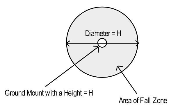
Guyed Tower - A monopole or lattice tower that is secured to the ground or other surface by diagonal cables for lateral support.
Height - The height above ground level (AGL) from the natural grade of a site to the highest point of a structure.
Lattice Tower - A type of mount with multiple legs and structural cross-bracing between the legs that is self-supporting and free-standing.
Mast - A thin pole that resembles a street light standard or a telephone pole. A dual-polarized antenna is typically deployed on a mast.
Monopole - A thicker type of mount than a mast that is self-supporting with a single shaft of wood, steel, concrete, or other material, that is designed for the placement of antennas and arrays along the shaft.
Mount - The structure or surface upon which antennas are mounted, including the following four types of mounts:
Roof-mounted. Mounted on the roof of a building.
Side-mounted. Mounted on the side of a building.
Ground-mounted. Mounted on the ground.
Personal Wireless Service Facility – Facility for the provision of personal wireless services, as defined by the Telecommunications Act of 1996, as amended. Personal Wireless Service Facilities include a mount, antenna, equipment shelter, and other related equipment. Specific Definitions pertinent to Personal Wireless Service Facilities follow.
Personal Wireless Services - The three types of services regulated by this Ordinance: Commercial mobile radio services, unlicensed wireless services, and common carrier wireless exchange access services as described in the Telecommunications Act of 1996, as amended.
Radio Frequency (RF) Engineer - An engineer specializing in electrical or microwave engineering, especially the study of radio frequencies.
Radio Frequency Radiation (RFR) - The emissions from personal wireless service facilities.
Security Barrier - A wall, fence, or berm that restricts an area from unauthorized entry or trespass.
§ 175-100District Regulations
Location. Personal wireless service facilities shall be permitted in all Zoning Districts, except as restricted by this Article. Applicants seeking approval for personal wireless service facilities shall first evaluate existing structures for the siting of personal wireless service facilities. Only after finding that there are no suitable existing structures pursuant to Section 175-101. C. herein, shall a provider propose a new ground mounted facility. Applicants for new PWSF shall place antennas and towers at locations which will minimize the impact on residential neighborhoods. In no case shall a PWSF be allowed in designated conservation areas unless they are located on existing tower facilities.
Existing Structures – Policy. Personal wireless service facilities shall be located on existing structures, including but not limited to buildings, water towers, existing telecommunications facilities, utility poles or towers, and related facilities, provided that such installation preserves the character and integrity of those structures.
Existing Structures – Burden of Proof. The applicant shall have the burden of proving that there are no existing structures which are suitable to locate its personal wireless service facility and/or transmit or receive radio signals. To meet that burden, the applicant shall take all the following actions to the extent applicable:
The applicant shall submit to the Department of Planning and Community Development a list of all contacts made with owners of potential sites regarding the availability of potential space for a personal wireless service facility. If the Planning Board or Department of Planning and Community Development informs the applicant that additional existing structures may be satisfactory, the applicant shall contact the property owner(s) of those structures.
The applicant shall provide copies of all letters of inquiry made to owners of existing structures and letters of rejection. If letters of rejection are not provided, at a minimum, unanswered “Return Receipt Requested” forms from the U.S. Post office shall be provided for each owner of existing structures that was contacted.
If the applicant claims that a structure is not capable of physically supporting a personal wireless service facility, this claim must be certified by a licensed professional civil engineer. The certification shall, at a minimum, explain the structural issues and demonstrate that the structure cannot be modified to support the personal wireless service facility without unreasonable costs. The estimated cost shall be provided to the Planning Board.
Ground Mounted Facilities – Policy. If the applicant demonstrates that it is not feasible to locate on an existing structure, ground mounted personal wireless service facilities shall be designed so as to be camouflaged to the greatest extent possible, including but not limited to: use of alternative tower structures, use of compatible building materials and colors, screening, landscaping, and placement within trees. If the applicant does not propose the use of alternative tower structures, then the applicant shall provide evidence as to why it is unsuitable. Costs of alternative tower structures that exceed regular tower or antenna development shall not be presumed to render the alternate tower structure unsuitable.
Locations for Ground Mounted Facilities. Ground mounted personal wireless service facilities shall be prohibited from those areas identified on the “Town of Durham, NH Visual Sensitivity Project - Composite Overlay,” dated March 13, 1998, and prepared by Strafford Regional Planning Commission using data from the original map created by Complex Systems Research Center, Institute for the Study of Earth, Oceans, and Space, University of New Hampshire. The “Town of Durham, NH Visual Sensitivity Project - Composite Overlay” is hereby adopted as an overlay to the official Zoning Map of the Town of Durham and incorporated in this Article by reference. If the site is within or adjacent to a residential zone, then a study shall be provided showing which alternative sites that are not within or adjacent to a residential zone were considered and why these locations are not acceptable.
All PWSF – Policy. All applicants for PWSF shall submit information related to the availability of alternative technologies. If no alternative technologies exist to accommodate the applicant’s proposed PWSF, then the applicant shall submit evidence to demonstrate that no alternative technologies can accommodate the applicants proposed PWSF and said evidence may include, but is not limited to, the following: that an alternative technology that does not require the use of towers or structures, such as a cable microcell network using multiple low-powered transmitters/receivers attached to a wire line system, is unsuitable. Costs of alternative technology that exceed new tower or antenna development shall not be presumed to render the technology unsuitable.
§ 175-101Use Regulations
A personal wireless service facility shall require a building permit in all cases and may be permitted as follows:
Existing Tower Structures. Subject to the issuance of a building permit that includes review by the Director of Planning and Community Development, carriers may locate a personal wireless service facility on any guyed tower, lattice tower, mast, or monopole in existence prior to the adoption of this Article, or on any personal wireless service facility previously approved under the provisions of this Article so long as the co-location complies with the approved site plan. All the Performance Standards from this Article shall be met. This provision shall apply only so long as the height of the mount is not increased, a security barrier already exists, and the area of the security barrier is not increased. Otherwise, site plan review is required.
Reconstruction of Existing Tower Structures. An existing guyed tower, lattice tower, monopole, or mast in existence prior to the adoption of this Article may be reconstructed with a maximum 20-foot increase in height so as to maximize co-location so long as the standards of this Article are met and so long as this 20-foot increase in height does not cause a facility previously existing at less than 200 feet to exceed 200 feet in height. The mount shall be replaced with a similar mount that does not significantly increase the visual impact on the community. Site plan review is required.
Existing Structures. Subject to the provisions of this Article and site plan review and except as otherwise permitted under Section 175-101.A, a carrier may locate a personal wireless service facility on an existing structure, building, utility tower or pole, or water tower. If siting on a utility pole, the protrusions from the face of the pole should be no greater than ½ the diameter of the pole itself and in no cases greater than 12 inches. If antennas are included in a random shield on top of the pole, the shield shall have a maximum overhang of 4 inches. In no instance shall the pole be wider than the minimum necessary to support the proposed equipment. Both Cellular and PCS can use dual-polarized antennas.
Ground Mounted Facility. A personal wireless service facility involving construction of a ground mount shall require site plan review and be subject to the provisions of this Article.
§ 175-102Dimensional Requirements
Personal wireless service facilities shall comply with the following requirements:
Height, Maximum. In no case shall a personal wireless service facility exceed 200 feet in height, unless the mount for the facility was greater than 200 feet in height prior to the adoption of this Article. The applicant shall demonstrate by technological evidence that the height requested is the minimum height necessary to fulfill the site’s function.
Height, Existing Structures and Utility Poles. Carriers that locate new personal wireless service facilities on water towers, electric transmission and distribution towers, utility poles and similar existing utility structures, guyed towers, lattice towers, masts, and monopoles may be permitted to increase the height of those structures no more than 20 feet. This increase in height shall only be permitted once for each structure.
Height, Other Existing Structures. The height of a personal wireless service facility shall not increase the height of a structure by more than 10 feet, unless the facility is completely camouflaged; for example a facility completely within a flagpole, steeple, or chimney. The increase in the height of the structure shall be in scale and proportion to the structure as originally configured. A carrier may locate a personal wireless service facility on a building that is legally non-conforming with respect to height, provided that the provisions of this Article are met.
Height, Ground-Mounted Facilities. Ground-mounted personal wireless service facilities shall not project higher than 10 feet above the average tree canopy height within a 100 and 150-foot perimeter of the mount, security barrier, or designated clear area for access to equipment, whichever is greatest.
Setbacks. All personal wireless service facilities and their equipment shelters shall comply with the building setback provisions of the zoning district in which the facility is located. Fences shall comply with the setback provisions of the zoning district in which the facility is located if the fence is 6 feet or more in height.
Fall Zone for Ground Mounts. In order to ensure public safety, the minimum distance from the base of any ground-mount of a personal wireless service facility to any property line, public road, habitable dwelling, business or institutional use, or public recreational area shall be, at a minimum, the distance equal to the fall zone, as defined in this Article. The fall zone may cross property lines, so long as the applicant secures a fall zone easement from the affected property owner(s). The area of the easement shall be shown on all applicable plans submitted to the Town, and the terms of the easement shall be provided as part of the site plan review.
Fall Zone for Non-Ground Mounts. In the event that an existing structure is proposed as a mount for a personal wireless service facility, a fall zone shall not be required, but the setback provisions of the zoning district shall apply. In the case of pre-existing non-conforming structures, personal wireless service facilities and their equipment shelters shall not increase any non-conformity.
Planning Board Flexibility. Heights - In reviewing a site plan application for a personal wireless service facility, the Planning Board may permit an increase in the height of a ground mounted facility up to 20 feet above the average tree canopy height, if no material increase in visual or environmental impacts will result from the increased height. The visual and environmental criteria of this Article and the Site Plan Review Regulations shall be the guidelines in making this determination.
§ 175-103Performance and Design Standards
Visibility
Visual impacts are measured on the basis of:
Change in community scale, as exhibited in relative height, mass or proportion of the personal wireless service facility within their proposed surroundings.
New visible elements proposed on a contrasting background.
Different colors and textures proposed against a contrasting background.
Use of materials that are foreign to the existing built environment.
Enhancements are measured on the basis of:
Conservation of opportunities to maintain community scale, e.g., buffering areas and low-lying buildings should not be compromised so as to start a trend away from the existing community scale.
Amount and type of landscaping and/or natural vegetation.
Preservation of view corridors, vistas, and viewsheds.
Continuation of existing colors, textures, and materials.
Visibility focuses on:
Eliminating or mitigating visual impact.
Protecting, continuing, and enhancing the existing environment.
Concealment or Camouflage for Facilities on Existing Buildings or Structures - Roof Mounts: When a personal wireless service facility extends above the roof height of a building on which it is mounted, every effort shall be made to conceal or camouflage the facility within or behind existing or new architectural features to limit its visibility from public ways. Facilities mounted on a roof shall be stepped back from the front facade in order to limit their impact on the building’s silhouette.
Concealment or Camouflage for Facilities on Existing Buildings or Structures - Side Mounts: Personal wireless service facilities which are side mounted shall blend with the existing building's architecture and, if individual antenna panels are over 5 square feet, the panels shall be painted, shielded, or concealed with material consistent with the design features and materials of the building.
Camouflage for Ground Mounted Facilities: All ground-mounted personal wireless service facilities shall be surrounded by a buffer of dense tree growth that extends continuously for a minimum distance of 150 feet from the mount, security barrier, or designated clear area for access to equipment, whichever is greatest, and screens views of the facility in all directions, as set forth in Figure XVIII – 2. These trees must be existing on the subject property, planted on site, or be within a landscape easement on an adjoining site. The Planning Board shall have the authority to decrease, relocate, or alter the required buffer based on site conditions. The 150-foot vegetative buffer area shall be protected by a landscape easement or be within the area of the carrier’s lease. The easement or lease shall specify that the trees within the buffer shall not be removed or topped, unless the trees are dead or dying and present a hazard to persons or property.
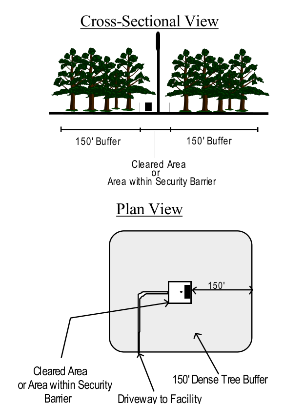
Color - To the extent that any personal wireless service facilities extend above the height of the vegetation immediately surrounding it, they shall be of a color which blends with the background or surroundings.
Equipment Shelters - Equipment shelters for personal wireless service facilities shall be designed consistent with one of the following design standards:
Equipment shelters shall be located in underground vaults; or
Equipment shelters shall be designed so that the shelters are architecturally consistent, with respect to materials and appearance, to the buildings in the area of the personal wireless service facility; or
Equipment shelters shall be camouflaged behind an effective year-round landscape buffer, equal to the height of the proposed building, and/or wooden fence. The Planning Board shall determine the style of fencing and/or landscape buffer that is compatible with the neighborhood; or
If mounted on a roof top, the equipment shelter shall be concealed or camouflaged so that the shelter either is not visible at grade or appears to be a part of the original structure.
Lighting, Signage, and Security
Lighting:
The mounts of personal wireless service facilities shall be lighted only if required by the Federal Aviation Administration (FAA).
Lighting of equipment structures and any other facilities on site shall be shielded from abutting properties. Foot-candle measurements at the property line shall be 0.0 initial foot candles.
Signage: Signs shall be limited to those needed to identify the property and the owner and warn of any danger. All signs shall comply with the requirements of the Article XXIII of the Durham Zoning Ordinance.
Security Barrier: The Planning Board shall have final authority on whether a ground mounted personal wireless service facilities should be surrounded by a security barrier.
Historic Buildings and Districts
Any personal wireless service facility located on or within an historic structure shall not alter the character-defining features, distinctive construction methods, or original historic materials of the building.
Any alteration made to an historic structure to accommodate a personal wireless service facility shall be fully reversible.
Personal wireless service facilities authorized by this subsection shall be concealed within or behind existing architectural features, or shall be located so that they are not visible from public roads and viewing areas.
Personal wireless service facilities located in the Durham Historic Overlay District shall comply with the provisions of Article XVII.
Scenic Landscapes and Vistas - Personal wireless service facilities shall not be located within open areas that are visible from public roads, recreational areas, or abutting properties. All ground-mounted personal wireless service facilities shall be surrounded by a buffer of dense tree growth as per Section 175-103.A.6.
Driveways - Existing entrances and driveways to serve a personal wireless service facility shall be utilized, unless the applicant can demonstrate that a new entrance and driveway will result in less visual, traffic, and environmental impact. New driveways to serve a personal wireless service facility shall not exceed 12 feet in width. A gravel or crushed stone surface is encouraged.
Antenna Types - Any antenna array placed upon an existing or proposed ground mount, utility pole, or transmission line mount shall have a diameter of no more than 4 feet, exclusive of the diameter of the mount. A larger diameter antenna array may be permitted after a finding by the Planning Board that the visual impacts of a larger antenna array are negligible.
Ground and Roof Mounts - All ground mounts shall be of a mast type mount. Lattice towers, guyed towers, and roof mounted monopoles are expressly prohibited, unless constructed as part of a reconstruction project permitted under Section 175-102.B.
Hazardous Waste - No hazardous waste shall be discharged on the site of any personal wireless service facility. If any hazardous materials are to be used on site, there shall be provisions for full containment of such materials. An enclosed containment area shall be provided with a sealed floor, designed to contain at least 100 and 110 percent of the volume of the hazardous materials stored or used on the site.
Noise - Personal wireless service facilities shall not generate noise in excess of that permitted under the Durham Noise Ordinance for intermittent noise.
Radio Frequency Radiation (RFR) Standards - All equipment proposed for a personal wireless service facility shall be fully compliant with the FCC Guidelines for Evaluating the Environmental Effects of Radiofrequency Radiation (FCC Guidelines), under Report and Order, FCC 96-326, published on August 1, 1996, and all subsequent amendments.
Interference – No antenna shall cause localized interference with the reception or transmission of any other communications signals including, but not limited to, public safety signals and television and radio broadcast signals. Certification by a qualified, licensed professional engineer that there will be no interference must be submitted.
§ 175-104Monitoring and Maintenance
Maintenance - The owner of the facility shall maintain the personal wireless service facility in good condition. Such maintenance shall include, but shall not be limited to, painting, structural integrity of the mount and security barrier, and maintenance of the buffer areas and landscaping.
Monitoring - As part of the issuance of the site plan approval or building permit, the property owner shall agree that the Town of Durham may enter the subject property to obtain RFR measurements and noise measurements at the expense of the carrier. The Town shall provide reasonable written notice to the carrier and landowner and provide them the opportunity to accompany the Town representatives when the measurements are conducted.
Security for Removal - Recognizing the hazardous situation presented by abandoned and unmonitored telecommunications facilities, the Planning Board shall set the form and amount of security that represents the cost for removal and disposal of abandoned telecommunications facilities in the event that a facility is abandoned and the facility owner is unwilling or unable to remove the facility in accordance with Section 175-105.B. The amount of the security shall be based upon the removal cost plus, 15 percent, provided by the applicant and certified by a professional civil engineer licensed in New Hampshire. The owner of the facility shall provide the Planning Board with a revised removal cost estimate and structural evaluation prepared by a professional civil engineer licensed in New Hampshire every 5 years from the date of the Planning Board’s approval of the site plan. If the cost has increased more than 15 percent then the owner of the facility shall provide additional security in the amount of the increase.
§ 175-105Abandonment or Discontinuation of Use
Notification - At such time that a carrier plans to abandon or discontinue operation of a personal wireless service facility, such carrier will notify the Town by certified U.S. mail of the proposed date of abandonment or discontinuation of operations. Such notice shall be given no less than 30 days prior to abandonment or discontinuation of operations. In the event that a carrier fails to give such notice, the personal wireless service facility shall be considered abandoned upon such discontinuation of operations.
Removal - Upon abandonment or discontinuation of use, the owner of the facility shall physically remove the personal wireless service facility within 90 days from the date of abandonment or discontinuation of use. "Physically remove" shall include, but not be limited to:
Removal of antennas, mount, equipment shelters and security barriers from the subject property.
Proper disposal of the waste materials from the site in accordance with local and state solid waste disposal regulations.
Restoring the location of the personal wireless service facility to its natural condition, except that any landscaping and grading shall remain in the after-condition.
Failure to Remove - If the owner of the facility does not remove the facility upon the Zoning Administrator’s order, then the Town Council shall, after holding a public hearing with notice to the owner and abutters, issue a declaration of abandonment. The owner of the facility shall dismantle and remove the facility within 90 days of receipt of the declaration of abandonment by the Town Council. If the abandoned facility is not removed within 90 days, the Town may execute the security to pay for this action.
Article XVIII.1Attainable Housing Overlay District
§ 175-106Attainable Housing Overlay District (AHOD)
The following provisions apply to the Attainable Housing Overlay District.
Purpose of the Attainable Housing Overlay District. This overlay district is intended to:
provide reasonable and realistic opportunities for the development of workforce and affordable housing;
ensure the availability of a diverse supply of rental opportunities;
provide an adequate supply of affordable housing in Durham as set forth in the Town’s 2015 and 2018 Master Plan including the Demographics and Housing Chapter (https://www.ci.durham.nh.us/planning/master-plan-2015) and the Town’s May 2024 Housing Needs Assessment (https://www.ci.durham.nh.us/bc-housingtaskforce); and
address the regional need for affordable housing as documented in the Strafford Regional Planning Commission’s Housing Needs Assessment (https://strafford.org/uploads/documents/plans/rpc/rhna_2023.pdf) as updated.
Authority. The Town of Durham adopts this Attainable Housing Overlay District and related sections in this Zoning Ordinance under the authority of RSA 674:15-18 Purpose of Zoning Ordinance, RSA 674:58-61 Workforce Housing and RSA 674:21, Innovative Land Use Controls.
Applicability. The provisions of the Attainable Housing Overlay District apply to the following areas of Durham (See Attainable Housing Overlay District Zoning Map):
The entirety of the land zoned Office and Research District – Route 108 (OR) that is situated on the easterly side of Dover Road/Route 108.
All portions of the lot identified as Map 209, Lot 39, currently zoned Residence Coastal, that are situated westerly of the ordinary high water mark on the westerly side of Johnson Creek.
Tax Map 210, Lots 10, 11, 12, 13, 14, and 15.
The references above are made as of the date when this amendment is adopted. Should any of the pertinent land be rezoned in the future or changes to map and lot numbers be made the specific lands identified as being part of the overlay district included at the time of adoption of this overlay district shall not change unless a specific zoning amendment is made in the future to that effect.
The Attainable Housing Overlay District is depicted on the map identified as Attainable Housing Overlay District – Supplement to Official Zoning Map. In case of any conflict between the description above and the rendering on the map, the description of the zone, above, will prevail.
Any parcel of land located in the overlay district may be developed as an attainable housing project in accordance with the provisions of the Attainable Housing Overlay District by right at the option of the landowner pursuant to the provisions of this article.
Workforce Housing Option under Conservation Subdivisions. Special provisions for workforce housing that is part of a conservation subdivision are given in Article XIX - Conservation Subdivisions. Those provisions are entirely independent from this overlay district and neither may be applied to the other nor may the two be combined in any manner.
Dwelling Units. Within a project developed under this ordinance:
No single family house lot may be created.
Units shall be offered exclusively for rent, not for sale.
Bedrooms. No units may contain more than three bedrooms. The number of three-bedroom units may not exceed 1/3 of the total number of dwelling units in the project. Otherwise, the mix of units by number of bedrooms is set at the discretion of the applicant. A mix of studios, and one- two- and three- bedroom units is encouraged.
Housing Types. Residential units in an attainable housing development are restricted to missing middle housing types only (See Definition). A mix of housing types and unit sizes arranged in different configurations is encouraged but not required. No individual building (including rowhouses and townhouses) may contain more than 12 dwelling units.
HUD Fair Market Rent. Rent levels are established for all attainable housing units (including any units that are subleased) based upon the U. S. Housing and Urban Development (“HUD”) Fair Market Rent which is set based on the number of bedrooms in a unit. The rent levels are reset by HUD every year. The fair market rent (or some percentage of the fair market rent, below) is the figure for which the unit is offered. It does not consider other costs to tenants.
Rents may be set at the discretion of the property owner provided:
Most units will likely be rented at the HUD Fair Market Rent with the exceptions in 2. and 3., below.
There is some flexibility in setting rent levels. Each unit shall be rented at some percentage of the HUD Fair Market Rent, e.g., exactly at HUD Fair Market Rent which would be 100%, at 80%, etc. The average of all of the percentages for all of the units in the project (independent of the number of bedrooms in units) shall not exceed 100%. (For example: 10 units are rented at 100% of the HUD Fair Market Rent level, 5 units are rented at 60% of HUD Fair Market Rent, and 5 units are rented at 120% of HUD Fair Market Rent. The average of those percentages is 95% which would be in compliance since the average is less than 100%.)
At least 20% of the overall number of units (independent of the size of the units) shall be rented at 80% of HUD Fair Market Rent level or less.
Rental units must be the primary residence for all lessees.
Housing Vouchers. Property owners must be willing to accept Section 8/Housing Vouchers for payment of rent provided the total amount of rent paid for a unit is consistent with the established rent for the unit. This provision does not require that priority be given to Section 8/Housing Vouchers, but only that the property owner be willing to accept them.
Housing Guarantees. The primary purpose of this overlay district is to provide attainable housing for members of the workforce and the community. The property owner shall not accept guarantees from third parties who will not reside in the rental unit (This provision does not apply to Section 8/Housing Vouchers).
Allowed Uses. The uses allowed in any project developed under this overlay district are the residential uses specified in this section, all uses allowed in the underlying base zoning district, day care centers, and common accessory uses to these uses (such as a clubhouse and outdoor recreation serving residents). Institutional Uses, Offices, Restaurants, and small Retail Stores (with less than 5,000 gross square feet), are allowed by conditional use (unless allowed by right in the underlying zoning district).
Density and Dimensional Standards. The density and dimensional standards for the Attainable Housing Overlay District are specified in the Table 175-54 – Table of Dimensions. These standards (in the table and below) apply throughout the Attainable Housing Overlay District superseding the standards otherwise applicable to the underlying base zoning districts.
Density. The density standard is given in the Table of Dimensions. The standard is established for the overall site based upon lot area per dwelling unit. All areas of the subject parcel apply to the density calculation except for wetlands and areas of open water.
Maximum number of units. The maximum number of dwelling units for any attainable housing development is 200 units. This maximum applies to any individual lot or tract proposed for a project, including any project to be developed in phases. Appropriate restrictions may be specified for any project to prevent pre-emptory subdivision that might circumvent this provision. The Planning Board may approve more than 200 units in a project by conditional use.
Senior units. There is no density bonus for senior residential units. Section 175-57 A. l. Density for senior residential units does not apply to projects developed under this overlay district.
Other Zoning Parameters. All other standards in the Zoning Ordinance shall apply to a project unless superseded by a specific provision in this overlay district.
Buffers. Depending on the location and characteristics of the proposed development, the surrounding properties, and the adjacent roads the Planning Board may require that the developed area be buffered from surrounding property and the adjacent roads.
Low Income Housing Tax Credit project. The Planning Board may approve by conditional use any departure from this article and from the Zoning Ordinance to accommodate a project proposed to be funded through the Low Income Housing Tax Credit, where any requirement of the tax credit program is inconsistent with this article or the Zoning Ordinance.
Perpetuity. All attainable housing units must remain as attainable units in perpetuity in accordance with HUD figures and the conditions of project approval. As part of any project, appropriate provisions, such as deed restrictions or easements, shall be incorporated to carry out this requirement. The Town of Durham or their agents may require periodic reporting and audits at its option.
Site Plan and Subdivision Regulations. An attainable housing project developed under this overlay district is exempt from Article XIX – Conservation Subdivisions and from all sections under the Subdivision Regulations related to conservation subdivisions. Where there is no subdivision into separate lots of land a project is reviewed under the Site Plan Regulations. Separate components of a project may be subdivided into separate parcels as part of phasing of a project or an overall development plan, in which case creation of new parcels will be reviewed as a subdivision under pertinent elements of the Subdivision Regulations. Lots which are not intended to be part of an attainable housing development may be subdivided from the parent parcel of land provided that portion of the development complies with other applicable requirements.
Topography and Open Space. A full topographic survey shall be prepared. A minimum of 60% of the gross acreage of the parcel shall be set aside as permanent open space. The applicant shall prepare an open space plan providing for the appropriate use, maintenance, and protection of the open space to be approved by the Planning Board. On sites where both Town water and sewer are not available the applicant shall prepare a HISS analysis of the entire site. A HISS analysis is not required when both Town water and sewer are available.
The Planning Board will determine which portions of the parcel will be set aside for open space in order to optimally preserve natural and cultural resources, enhance forest management, and provide opportunities for agriculture and passive recreation in accordance with criteria a. through g. under Article XIX. Conservation Subdivisions, Section 175-107, Subsection H. Common Open Space, Subsection 3.
Design. The Planning Board shall use its judgment in reviewing the proposed design, layout, and density of the project to ensure a harmonious living environment for the future residents.
All residential buildings must front a pedestrian-oriented designed street or way and not simply a parking lot.
All residential buildings must form a pedestrian-oriented ensemble.
There must be a network of streets or ways allowing for pedestrian movement through the site.
All parking areas must be broken up into smaller areas or with sufficient landscaping to avoid large expanses of parking.
Parking and Transportation. The applicant shall develop a transportation plan for the project pursuant to Article 11 – Pedestrian, Bicycle, and Transit Facility Standards in the Site Plan Regulations. The minimum number of parking spaces required for any dwelling unit is one.
Infrastructure. Roads, water and sewer infrastructure, and other infrastructure shall be owned and maintained by the developer or by the Town of Durham as determined by the Planning Board in consultation with the Town Administrator and Durham Public Works Department (and/or the Town Council pursuant to other applicable law).
Incentives. The Planning Board may negotiate with the applicant to allow for additional density or reduced open space in exchange for inclusion of various elements that will enhance the quality of the project, including, but not limited to, additional open space, public recreation facilities, agricultural leases, active transportation connections, sustainability measures, and a reduction in the average rent level significantly below 100% of the HUD Fair Market level. This bonus should not be provided for elements that would likely be incorporated in the regular course of site plan review. The maximum increase in density allowed under this provision is 20%. This allowance could also be used to raise the threshold of 200 units beyond which a conditional use would be required.
Article XIXConservation Subdivisions
§ 175-107Conservation Subdivisions
This section was adopted pursuant to the Town of Durham’s 2000 Master Plan which recommended that conservation subdivisions, in which a substantial portion of the site is set aside as permanent, common open space, be the primary form of residential development in the community. The provisions of this section govern the design and development of conservation subdivisions. The process for the design of conservation subdivisions, as set forth in the Town’s Subdivision Regulations, requires that key natural, historic, archeological, and cultural features on the site be identified for protection and the development planned to protect these resources.
Purpose. The purposes of these provisions are to assure that conservation subdivisions developed in the Town of Durham:
Preserve those areas of the site that have the highest value for conservation purposes;
Preserve identified historic, known archeological and identified cultural features located on the site:
Locate the buildings and structures on those portions of the site that are most appropriate for development considering both the development suitability of the site and its conservation value;
Create continuous open spaces or “greenways” by linking the common open spaces in adjoining subdivisions wherever possible; and
Minimize the impact of residential development on the Town, neighboring properties, and the natural environment.
Applicability. All residential subdivisions in the Residence A District, Residence B District, Residence Coastal District, Rural District, Office Research Light Industry District, and Mixed Use and Office Research District shall be developed as Conservation Subdivisions in accordance with the provisions of this section and the Town’s Subdivision Regulations unless the subdivision is exempt from this requirement based upon subsection C. below.
Exempt Subdivisions. A proposed subdivision is exempt from being developed as a Conservation Subdivision only if the proposed subdivision meets one of the following criteria. In determining if the criteria are met, any lot that has been or will be transferred to a qualified conservation organization (as defined in Article II) and will be restricted to conservation use in perpetuity, shall not be counted as a lot for the purpose of this provision.
Three-lot subdivision. The subdivision will consist of a total of 3 or fewer lots accommodating a total of not more than 3 dwelling units (not including accessory dwelling unit - attached) and there will be no potential for the future subdivision of the parcel or any of the lots created by the subdivision (other than for a boundary line adjustment) nor for the construction of additional dwelling units on any of the lots, or
Four hundred thousand square foot lots. The subdivision will consist of lots, all of which will have a minimum lot area of 400,000 square feet , and there will be no potential for the future subdivision of the parcel or any of the lots created by the subdivision nor for the construction of additional dwelling units on any of the lots, or
Three lots with future plan. The subdivision will consist of 3 or fewer lots accommodating a total of not more than 3 dwelling units, there is additional land that may be developable in the future for which a Conceptual Long Range Development Plan meeting the requirements of subsection N. will be prepared, all lots being created as part of the exempt subdivision will be consistent with and incorporated into the long range plan as part of a conservation subdivision, and no additional lots will be created in the future that are not part of a conservation subdivision, or
One lot each 7 years. The subdivision will create not more than 1 additional lot accommodating 1 dwelling unit and no other lots have been created from the parcel within the preceding 7-year period. This exemption allows for the subdivision of 1 lot at a time, leaving residual land for potential future subdivisions, provided that at least 7 years pass between subdivisions.
Any subdivision created under Article XVIII.1 Attainable Housing Overlay District.
Maximum Development Density. The maximum number of dwelling units that may be developed in a Conservation Subdivision shall be determined by dividing the calculated Usable Area of the parcel by the required Minimum Usable Area Per Dwelling Unit for the district in which the subdivision is located (see Section 175-54, Table of Dimensions) and rounding down to the maximum allowed whole number of units. If the parcel is located in more than one district, the maximum number of units allowed on the portion of the parcel in each district shall be calculated separately and the allowed maximum number of units (including fractional units) in each district shall be added together and then rounded down to the allowed number of whole units. If the subdivision involves only part of a parcel, the Usable Area shall be calculated for that portion of the parcel proposed to be included in the subdivision and the determination of the maximum number of dwelling units within the subdivision determined based upon that Usable Area. The Planning Board shall not approve a plan for a Conservation Subdivision that provides for the development of more dwelling units than the maximum number determined by this section.
Lots in a Conservation Subdivision. Residences in a Conservation Subdivision may be located on individual residential lots, or on common lots with more than 1 dwelling unit on a lot, or a combination thereof. If more than 1 dwelling unit will be located on a lot, the ownership and management arrangements for that lot, and the units thereon, shall be detailed as part of the subdivision application and those arrangements shall be subject to approval by the Planning Board in accordance with the Subdivision Regulations.
Individual Lot Sizes. If individual lots are created as part of a Conservation Subdivision, the lots shall conform to the following minimum lot size requirements:
Any lot that has its required lot frontage on a public street that existed as of July 1, 2003 shall conform to the minimum lot size requirement for the district in which it is located (see Section 175-54, Table of Dimensions).
Any lot that has its required lot frontage on a public street created after July 1, 2003, including streets to be developed as part of the subdivision or private ways, may be smaller than the required minimum lot size for the district in which it is located. The size of the individual lots shall be shown on the subdivision plan and shall be subject to Planning Board approval based upon its finding that the lot sizes will allow for the creation of a high quality living environment for the residents of the subdivision and provide for adequate sewage disposal, but in no case shall any lot served by a private wastewater disposal system be less than 10,000 square feet in area.
Individual Lot Frontages. If individual lots are created as part of a Conservation Subdivision, the lots shall conform to the following minimum lot frontage requirements:
Any lot that has its required lot frontage on a public street that existed as of July 1, 2003 shall conform to the minimum lot frontage requirement for the district in which it is located (see Section 175-54, Table of Dimensions).
Lots that have frontage on a public street shall be laid out to minimize the number of curb cuts onto the public street through the use of shared or common driveways or other methods. In no case, shall 2 adjacent driveways be located on a public street that existed as of July 1, 2003 unless the driveways are separated by at least 100 feet or such other greater distance as required by other provisions of this ordinance.
Any lot that has its required lot frontage on a public street created after July 1, 2003, including streets to be developed as part of the subdivision or private ways, may have less frontage than the required minimum lot frontage for the district in which it is located. The amount of frontage for the individual lots shall be shown on the subdivision plan and shall be subject to Planning Board approval based upon its finding that the lot frontages will allow for the creation of a high quality living environment for the residents of the subdivision and provide adequate access to the residences and other facilities, but in no case shall any lot have less than 50 feet of lot frontage.
Common Open Space. A Conservation Subdivision shall provide for the permanent set aside and protection of common open space meeting the following requirements:
The amount of common open space provided within the subdivision shall be equal to or greater the sum of the following:
the percentage of the calculated Usable Area set forth below, plus
the unsuitable area of the parcel that is deducted from the gross area of the site to determine the Usable Area.
The minimum percentage of the usable area that shall be set aside for common open space shall be as follows:
Residence A District 30 percent Residence B District 40 percent Residence Coastal District 50 percent Rural District 50 percent All other districts 50 percent
If the parcel is located in 2 or more districts, the percentage of the usable area located in each district shall be calculated and the required minimum percentage of the usable area set aside for open space determined based upon the weighted average of the percentages for the various districts.
The location and layout of the common open space shall conform to the standards and process set forth in the Subdivision Regulations.
The common open space in a Conservation Subdivision shall not be used as the location for dwelling units or other nonresidential buildings or parking except as provided for below and shall only be used for the following purposes:
The conservation and protection of natural resource areas, wildlife habitats, scenic features or views, identified cultural or historic features such as stone walls, graveyards or cemeteries, and similar identified features or resources
Passive and active outdoor recreation uses and facilities including related accessory structures and buildings that are compatible with the overall scale and character of the subdivision provided that any building shall have a gross floor area of less than 200 square feet and the total gross floor areas of all such buildings shall be less than 1,000 square feet.
Indoor community or recreational facilities that primarily serve residents of the subdivision, have a total gross floor area for all such facilities of less than 2,000 square feet, and are compatible with the overall scale and character of the subdivision
Forest management and agricultural uses including animal husbandry that are specifically approved by the Planning Board as part of the subdivision approval
Support facilities necessary for the subdivision including community wells, stormwater management facilities, underground utility lines and related facilities such as sewer pump stations, small community storage buildings, and similar buildings and structures that are needed for the operation of the subdivision but not including personal storage buildings or sheds
Individual or group underground wastewater disposal systems or parts thereof, provided that this use was approved as part of the subdivision plan and that appropriate legal arrangements are established and approved by the Planning Board for the maintenance and operation of these facilities
Other appropriate uses that are compatible with the overall scale and character of the subdivision and that are specifically approved by the Planning Board
Permanent provisions for the use, ownership, and maintenance of the common open space including provisions for screening and buffering shall be established subject to approval by the Planning Board as part of the approval of the subdivision in accordance with the Subdivision Regulations.
Appropriate legal mechanisms for the on-going maintenance and stewardship of the common open space shall be established, including the creation of a stewardship account or payment to the Town’s Stewardship Fund as set forth in the Subdivision Regulations, subject to approval by the Planning Board as part of the approval of the subdivision in accordance with the Subdivision Regulations.
The minimum front yard setback for any lot with its required lot frontage on a public street in existence as of July 1, 2003 shall be the required minimum setback for the type of street and the district in which the subdivision is located (see Section 175-54, Table of Dimensions) or 30 feet whichever is greater.
The minimum front yard setback for any lot with its required lot frontage on a public street created after July 1, 2003, including streets to be developed as part of the subdivision or private ways, may be less than that required by the district regulations. The size of the minimum setback shall be shown on the subdivision plan, may vary from lot to lot or in different areas of the subdivision, and shall be subject to Planning Board approval based upon its finding that the setbacks will allow for the creation of a high quality living environment for the residents of the subdivision and provide for adequate privacy and public safety.
If the approved front yard setback for any lot is less than that required by the requirements of the district in which the subdivision is located (see Section 175-54, Table of Dimensions), any garage with garage doors that face the street, whether attached or detached, shall be located so that the front wall of the garage is located at least 2 feet behind the front wall of the principal building. This requirement shall not apply to a garage located in the basement of a single-family home.
If the approved front yard setback for any lot is less than that required by the requirements of the district in which the subdivision is located (see Section 175-54, Table of Dimensions), any accessory building shall be located so that the front wall of the accessory building is located at least 2 feet behind the front wall of the principal building.
When a side or rear yard of a lot containing a residence or other building abuts the external perimeter or property line of a Conservation Subdivision, the minimum side and rear yard setbacks shall be the required minimum setback for the district in which the subdivision is located (see Section 175-54, Table of Dimensions) unless the streetscape buffer requirements of L. result in a greater setback .
The minimum side and rear yard setbacks from internal property lines within a Conservation Subdivision may be less than the required setbacks established by the district regulations (see Section 175-54, Table of Dimensions). The size of the minimum setbacks shall be shown on the subdivision plan, may vary from lot to lot or in different areas of the subdivision, and shall be subject to Planning Board approval based upon its finding that the setbacks will allow for the creation of a high quality living environment for the residents of the subdivision and provide for adequate privacy and public safety.
Streetscape Buffer Adjacent to Existing Public Streets. A vegetated buffer strip shall be maintained along any public street existing as of July 1, 2003 that is adjacent to a Conservation Subdivision to minimize the visual impact of the Conservation Subdivision on the streetscape. The depth of the buffer strip shall be at least three times the minimum front yard setback requirement for the zoning district in which the parcel is located and the type of street (see Section 175-54, Table of Dimensions) or 100 feet whichever is greater. This provision shall be reduced to 25 feet for individual residential lots that front on public streets that existed as of July 1, 2003. No parking, buildings, structures, or recreational facilities shall be permitted within this buffer strip but accessory structures such as signs, walls, underground utility structures, and drainage facilities may be located within this buffer. The buffer strip may be crossed by driveways or access drives that run essentially perpendicular to the street. The buffer strip shall be naturally vegetated or landscaped in accordance with the landscaping provisions of Article XXII and the treatment shall be subject to approval by the Planning Board as part of the approval of the subdivision. Appropriate legal mechanisms shall be established by the subdivider, subject to approval by the Planning Board as part of the approval of the subdivision, to assure that the buffer strip will be permanently protected and maintained.
Perimeter Buffer. A vegetated buffer strip shall be maintained along the external perimeter or property line of the Conservation Subdivision to minimize the impact of the Conservation Subdivision on abutting properties. The width of the buffer strip shall be at least the minimum setback requirement for the zone in which the subdivision is located. If the subdivision abuts a water body or wetland, the width and treatment of the buffer shall be consistent with the requirements of the Wetland Conservation Overlay District and/or the Shoreland Protection Overlay District. No parking, buildings, structures, access roads or driveways, or recreational facilities shall be permitted within this buffer strip but accessory structures such as walls, underground utility structures, and drainage facilities may be located within this buffer. The buffer strip shall be naturally vegetated or landscaped in accordance with the landscaping provisions of Article XXII and the treatment shall be subject to approval by the Planning Board as part of the approval of the subdivision. Appropriate legal mechanisms shall be established by the subdivider, subject to approval by the Planning Board, to assure that the buffer strip will be permanently protected and maintained.
Conceptual Long Range Development Plan. When a Conservation Subdivision will not utilize the entire parcel and there is potential for future subdivision or development of the parcel or any of the lots being created, the application for subdivision approval shall include a Conceptual Long Range Development Plan showing the potential utilization of the lots and the balance of the parcel not being subdivided. The Long Range Plan is intended to be conceptual in nature, to rely on published data about natural resources relevant to the parcel and the built environment, and to demonstrate that the current subdivision proposal will not compromise important conservation values or the long-term development of the parcel as a Conservation Subdivision. This plan shall show the relationship of the proposed subdivision area to the balance of the parcel and to adjacent land. This plan shall analyze the conservation and development potential of the remaining area of the parcel and shall show, in general terms, the potential street network, open space areas, and development areas in a manner that demonstrates that both the proposed development and the future development can occur so that it conforms to the requirements for Conservation Subdivisions and preserves the significant natural resource and conservation values of the entire parcel.
§ 175-107.1Workforce Housing in a Conservation Subdivision
Applicants who seek to incorporate workforce housing into a conservation subdivision shall follow the procedures laid out in this section. Workforce housing developed under this section is entirely separate from attainable housing developed under the Attainable Housing Overlay District.
Purpose. The purpose of this Section is to provide an option for including workforce housing in Conservation Subdivisions that is consistent with the requirements of RSA 674:58-61 and will:
provide reasonable and realistic opportunity for the development of workforce housing;
ensure the continued availability of a diverse supply of home ownership and rental opportunities;
meet the goal of providing an adequate supply of affordable housing in Durham as set forth in the town’s Master Plan; and
address the regional need for workforce housing as documented in the Strafford Regional Planning Commission’s Housing Needs Assessment, as updated.
Authority. This section is adopted under the authority of RSA 674:21, Innovative Land Use Controls, and is intended as an “Inclusionary Zoning” provision as defined in RSA 674:21(I)(k) and 674:21(IV)(a), as well as RSA 672:1, III-e.
Applicability.
Development in accordance with the provisions of this Section is permitted as a Conditional Use in the Rural (R), Residential A (RA), Residential B (RB) and Office Research/Light Industry (ORLI) Districts as an option to Article XIX, Conservation Subdivision.
Permitted Uses. Single-family, duplexes, multi-units not to exceed 4 units, accessory dwelling unit - detached, and accessory dwelling unit - attached. A mix of housing types within the same subdivision is permitted within an application under this Section. Any housing type that exceeds more than 2 units shall be designated as workforce housing.
Procedural Requirements. Any applicant, who applies to the Planning Board for approval of a development that is intended to qualify as workforce housing under this section, shall follow the same procedure as outlined in the Town of Durham Subdivision Regulations and as provided for in the Developer’s Guidance Document for Affordable Housing, January, 2011 as updated. Any such applicant shall also file a written statement of such intent as part of the application as per RSA 674:60.
Definitions: The following terms as used in this section shall have the following definitions:
Reasonable and Realistic Opportunities for the development of Workforce Housing:
Opportunities to develop economically viable workforce housing within the framework of Durham’s municipal ordinances and regulations adopted pursuant to this chapter and consistent with RSA 672:1, III-e.
Workforce Conservation Subdivision: A Conservation Subdivision that provides rental or ownership housing opportunities to households based on the following standards: (1) workforce rental housing is defined as a housing unit that has a monthly rent not exceeding 30 percent of the gross income of a household earning no more than 60 percent of the Area Median Income for a 3-person household for the Portsmouth-Rochester Fair Market Rent Area as published annually by the United States Department of Housing and Urban Development consistent with RSA 674:58 II; (2) workforce ownership housing is defined as housing that can be purchased at a price, including the combination of mortgage loan debt service, property taxes and insurance, that does not exceed 30 percent of the gross income of a household earning no more than 100 percent of the Area Median Income for a 4-person household for the Portsmouth-Rochester Fair Market Rent Area as published annually by the United States Department of Housing and Urban Development consistent with RSA 674:58 II.
Area Median Income (AMI): the median income of the greater region, the HUD Fair Market Rent Area to which Durham belongs, as is established and updated annually by the US Department of Housing and Urban Development. Income considers both wage income and assets.
Density Incentive. In determining the maximum number of workforce housing dwelling units that are allowed in a conservation subdivision, these standards apply:
A workforce housing dwelling unit containing one bedroom or a studio unit without a separate bedroom counts as 0.33 dwelling units for the purpose of the density calculation; and
A workforce housing dwelling unit containing two or more bedrooms counts as 0.50 dwelling units for the purpose of the density calculation;
General Requirements of Workforce Housing Units.
The workforce housing units should be interspersed to the greatest extent possible throughout the overall development and not concentrated in a separate area of the Subdivision.
Phasing—The phasing plan for the development shall provide for the construction of workforce housing units concurrently with the market-rate units.
More than 50 percent of the workforce housing units in the development shall contain 2 or more bedrooms.
The subdivision plan must also adhere to the standards outlined in Section H and satisfactorily meet the following criteria:
The dwellings qualifying as workforce housing shall be compatible in exterior appearance and reasonably consistent with the market rate dwellings in the proposed Subdivision.
Alternative Lot Sizing: The Planning Board may authorize variations from the minimum lot sizes and lot dimensions specified by standards of the underlying zone through the Conditional Use Permit, provided the Planning Board determines that the following conditions are met:
All lots comply with the New Hampshire Department of Environmental Services requirements (RSA 485: A) for subsurface wastewater management (developments may utilize individual or community wells and/or septic systems) and private water wells within the decreased lot size; and
The objectives and standards of this article and the Subdivision Regulations are otherwise achieved.
Assurance of Affordability.
Certification of Income Levels All of the workforce housing units gained under this provision must meet the affordability requirements for workforce housing in Paragraph E (2) of this Section.
Assurance of Continued Affordability Workforce ownership housing units must retain the development criteria and affordability standards herein for a minimum period of 30 years through a suitable deed restriction, easement and/or mortgage deed instrument deemed acceptable to the Durham Planning Board and as monitored through reports provided to the Durham Planning Board by a selected third-party agent prior to the time of unit sale or resale.
Administration. This Section shall be administered by the Planning Board in cooperation with a third party property management entity that will be responsible for income verification and ongoing affordability compliance.
Conflict. If any provision of this Section is in conflict with the provisions of any other provisions of this ordinance, the more restrictive provision shall apply, except for any provision relating to reductions in standards for lot size, setbacks, or density, in which case the provisions of this Section shall apply.
§ 175-108Stewardship Fund
Payments to the Town to provide for the periodic monitoring of conformance with the conservation restrictions on common open space shall be deposited in the Town’s Stewardship Fund. The Stewardship Fund shall be maintained as a separate trust account and shall be used only for the monitoring of conservation restrictions. The use of the Fund shall be managed by the Town’s Conservation Commission. The Commission shall provide the Town Council with an annual accounting of the use of the fund. At its discretion, after consulting with the Conservation Commission, the Planning Board may approve an alternative arrangement to the stewardship fund as described here.
Article XXStandards for Specific Uses
§ 175-109Compliance Required
This article establishes performance standards for specific uses. These standards must be met for all activities involving the specified uses.
Accessory Buildings for Multi-unit and Nonresidential Use. The following standards apply to buildings that are accessory to multi-unit and nonresidential use:
There is a limit of 2 accessory buildings per lot (not including garages), except that additional accessory buildings may be approved by conditional use.
The building shall be used only in association with the principal use on the site.
The building shall be located to the side or rear of the principal building, except by conditional use.
Accessory Buildings for Single-Family Use. The following standards apply to buildings that are accessory to single-family use, not including garages and any additional connected space, agricultural buildings, and accessory apartments.
The maximum floor area of the building shall be 200 square feet.
The highest point on the building shall be not more than 14 feet above grade.
The building shall not be supplied with water, sewerage, or heat unless approved by special exception.
The building shall be used only for the personal use of the occupants of the premises on which it is located, and not for any commercial use except for an approved home occupation.
The building shall not be located forward of the front façade of the house.
The building shall be set back at least 10 feet from any property line.
Accessory dwelling unit - attached and Accessory dwelling unit - detached. (Both included under “Accessory dwelling unit/s” below, unless otherwise specified). Accessory dwelling units shall conform to the following standards:
Only 1 accessory dwelling unit shall be located on a lot with a single-family residence. The location of more than one accessory dwelling unit in conjunction with 1 single-family residence shall not be permitted.
Floor space. An accessory dwelling unit shall contain a minimum of 300 and a maximum of 850 square feet of floor space.
Parking. One parking space shall be provided for the accessory dwelling unit in addition to parking required for the single-family dwelling. The parking space may be situated within a driveway along with other vehicles provided it is readily accessed. The parking space may be established on site or off site but must be legally dedicated if the space is located off site.
Utilities. The property owner shall make adequate provisions for water supply and sewage disposal for the accessory dwelling unit in accordance with RSA 485-A:38. However, systems for the accessory dwelling unit separate from those serving the single-family dwelling are not required.
Dimensional standards. There are no additional requirements for lot size, frontage, space limitations, or other dimensional controls for an accessory dwelling unit beyond what would be required for a single-family residence without an accessory dwelling unit.
Ingress and egress. Attached accessory dwelling units shall have either an independent means of ingress and egress or ingress and egress through a common space shared with the single-family residence, at the option of the property owner.
Existing structures. An existing structure on site may be converted to an accessory dwelling unit even if that existing structure does not conform with setback or lot coverage requirements.
Permitting. An application shall be submitted to the Durham Code Administrator to establish an accessory dwelling unit. If a building permit will be needed, then a separate application is not required, provided that the building permit application states that the purpose of the application is for an accessory dwelling unit and provides necessary information about the proposed accessory dwelling unit.
Owner occupancy. A single-family residence with an accessory dwelling unit, whether an attached or a detached unit, shall be owner occupied, in accordance with RSA 674:72 VI., as follows:
The owner may reside in either the single-family house or the accessory dwelling unit. The property shall be their primary residence.
See Article II. Definitions for the definition of “owner.”
As part of an application for an accessory dwelling unit or a building permit to construct an ADU or upon request of the Code Administrator, the property owner shall demonstrate that the property is or will be their primary place of residence by providing an official record such as a driver’s license, voter registration card, vehicle registration, mortgage document, or other acceptable documentation.
Interruptions in occupancy. A temporary interruption in occupancy by an owner will not constitute a violation of this Section C. provided that the property is occupied by an owner for at least three years out of any five-year period. A temporary interruption in occupancy as allowed under this provision shall not be deemed to establish a nonconforming condition.
Under extraordinary circumstances, the Durham Town Administrator may grant the minimum relief from the requirement for owner occupancy necessary, beyond the allowance in the paragraph immediately above, for good cause.
Compliance and enforcement. When an ADU is occupied in violation of this section, the property owner of record shall be subject to a monthly fine beginning with the first month following the date on which a violation is determined to have existed as provided for in Section 175-10 of this ordinance. The Town shall have the right to receive on demand a written disclosure describing the occupancy status of any property with an ADU, in sufficient detail to determine compliance with this ordinance.
Nonconforming situations. When there is a legally established accessory dwelling unit on a single-family property in place prior to the adoption of this amendment herein (effective October 19, 2026) and the owner of that property does not reside on the premises on that date, the property is considered a legally established nonconforming use, subject to Section 175-28 - Nonconforming Uses of this ordinance.
Ownership by Mortgage Lender. The owner-occupancy requirement of this Section C. shall not apply to a mortgage lender who takes title to the subject property by foreclosure or deed in lieu of foreclosure. However, the requirement shall apply to a purchaser from such a mortgage lender.
Day care center. A day care center shall conform to the following standards:
Provisions shall be made for the safe drop-off and pick-up of children such that this activity will not create a traffic hazard, obstruct vehicular or pedestrian traffic, or adversely impact adjacent properties including those located on the other side of the street.
A day care center shall not be located on a minor street that is residential in character unless the Zoning Administrator finds that such a use will not create traffic in excess of what would be typically found on a residential street based upon a traffic study prepared by the applicant.
Day care home. For all day care homes, provisions shall be made for the safe drop-off and pick-up of children such that this activity will not create a traffic hazard, obstruct vehicular or pedestrian traffic, or adversely impact adjacent properties including those located on the other side of the street.
In addition, day care homes licensed to accommodate more than 6 children at any time shall conform to the following standards:
The day care home shall not be located on a minor street that is residential in character unless the Zoning Administrator finds that such a use will not create traffic in excess of what would be typically found on a residential street based upon a traffic study prepared by the applicant.
Home Occupation. The criteria for home occupations are given in the Definitions article. Any person seeking to establish a home occupation shall submit an application to the Zoning Administrator who shall review the application for conformance with the criteria for home occupations. The Zoning Administrator may specify adding parking space(s) to accommodate the home occupation at her/his reasonable discretion.
Hotels and Motels. A stay in a hotel or motel is restricted to less than thirty days (as defined in Article II – Definitions). However, a guest or guests may stay in a hotel or motel for thirty days or longer if allowed by special exception. The maximum that may be allowed by a special exception is a stay of 60 consecutive days and 90 days in any 6 month period.
Light Manufacturing. Light Manufacturing shall conform to the following standards:
Manufacturing activities shall be limited to the processing or fabrication of materials which does not involve basic processes such as the mechanical or chemical transformation of materials or substances into new products unless such basic processes do not result in any noise, odors, or vibrations that are perceptible at the property line of the parcel on which the use is located.
Assembly, processing, and fabrication activities not involving basic processes shall be conducted so that they will not result in objectionable noise, glare, vibration, odor, or electrical interference that will disturb or endanger adjacent properties.
All outside storage of raw materials, products, and wastes shall occur within fenced and screened areas. Storage areas shall be buffered from view from public streets and adjacent residential uses through a combination of fencing, landscaping, and/or berms.
Truck loading and material handling areas shall be located to the side or rear of the building. No overhead doors or other service or material delivery facilities shall be allowed on the side of the building facing a public street unless the Planning Board determines that there is no practical alternative.
Manufactured Housing. A manufactured housing unit shall conform to the following construction and siting standards in addition to any state requirements:
It was constructed after June 15, 1975, and certified as meeting the mobile home construction and safety standards of the Department of Housing and Urban Development.
It is at least 20 feet wide at the narrowest point.
The roof pitch shall be not less than a 2-foot rise for each 12 feet of horizontal run [2:12], and the roof shall have minimum 6-inch eaves or eaves and gutter.
It has roofing materials which are generally acceptable for site-built housing. Any roofing material may be used, provided that it has the appearance of a nonmetallic shingle, shake or tile roof.
It has siding material which has the appearance of wood, masonry or horizontal metal siding. Reflection from horizontal metal siding shall be not greater than that from siding coated with white gloss enamel.
It has a perimeter skirting that resembles a conventional house foundation and is constructed of brick, concrete, concrete block or pressure-treated wood.
It is placed on a permanent foundation approved by the Code Enforcement Officer.
The hitch and tongue of the manufactured home shall be removed.
Porkchop Subdivision. A porkchop subdivision is allowed in the RC and R Districts. The purpose of a porkchop subdivision is to allow limited subdivision of relatively large lots where there is significant back land but not sufficient street frontage to provide the minimum required frontage for each new lot. Developers of residential subdivisions of 2 or 3 lots in the RC and R Districts on existing town roads as of the date this chapter is enacted that are not conservation subdivisions, may elect to follow the requirements for porkchop subdivisions in Table 4-1, provided that at least 2 of the lots are entered from a common driveway whose maintenance is guaranteed in the deeds to the lots concerned. A common driveway to a porkchop subdivision will only serve a maximum of 3 lots. Adjacent porkchop subdivisions will not share a common driveway. Each porkchop subdivision will have a common driveway independent from any other subdivision. Other than the possibility that the rear lot (or lots) may take on somewhat of a porkchop shape, the lots shall not be unduly gerrymandered to take advantage of this section.
Table 4-1. Requirements for Optional Porkchop Subdivisions
| Porkchop subdivision lots | Minimum area (square feet) | Minimum frontage area (feet) |
|---|---|---|
| Each lot | 80,000 | 50 |
| Average, all lots | 120,000 | 125* |
*NOTE: The Planning Board is empowered to reduce the average frontage to not less than 100 feet in the case of a porkchop subdivision of a nonconforming lot into not more than 3 lots, provided that the requirement for minimum area is met.
Reuse of an Existing Agricultural Building. Any reuse of an agricultural building for a use other than an agricultural use shall conform to the following standards:
Any nonresidential reuse shall conform to the following standards:
There shall be no retail sale of goods not otherwise allowed in the zone.
The nonresidential activity shall occur completely within the agricultural building and there shall be no outside storage of material, equipment, or products.
The positive aspects of the architectural character of the building shall be maintained.
Exterior changes to the building shall be limited to minor changes or minor additions needed to provide access or comply with code requirements or which the Planning Board determines will enhance the building’s appearance and/or function without adversely impacting its architectural character.
Reuse of an Older Single-Family Home for a Low Impact Nonresidential Use. Any reuse of an older single-family home or residence shall conform to the following standards:
The architectural character of the building shall be maintained.
Exterior changes to the building shall be limited to minor changes or minor additions needed to provide access or comply with code requirements or which the Planning Board determines will enhance the building’s appearance and/or function without adversely impacting its architectural character.
The volume of traffic generated by the use shall not be more than twice the volume resulting from a typical single-family residence.
Any off-street parking created to serve the reuse shall be located to the side or rear of the building and shall be buffered from any abutting residential use by a landscaped buffer at least 20 feet in width that meets the requirements of Article XXII.
No noise, odors, dust, vibrations, or similar factors shall be produced in amounts greater than those typically resulting from a typical single-family residence.
Short-term rental. The following terms and conditions apply to a short-term rental.
A short-term rental may not be established until a permit to operate a short-term rental has been issued by the Zoning Administrator. The property owner shall submit an application to operate a short-term rental to the Zoning Administrator. The proposal shall be reviewed for compliance with all Building, Fire, and Life Safety Codes. Site plan review is not required for a short-term rental.
Special Exceptions. In those districts where a short-term rental is allowed by special exception, the property owner shall obtain a special exception prior to issuance of a permit to operate a short-term rental. The following specific requirements apply to special exceptions for short-term rentals:
ZBA Hearing. For notification purposes, abutting properties shall include those lots within 300 feet of the subject property.
Other Conditions. The Zoning Board of Adjustment may set additional conditions on the special exception based upon potential impact of the proposal to the neighborhood.
The site where the short-term rental is located must be the property owner’s primary residence.
Those areas of the premises open to use by lodgers remain subject to periodic safety inspections per state law.
No recreational vehicle, travel trailer, tent, or other temporary shelter may be used by the renter(s) on the premises in conjunction with the short-term rental.
Signage is restricted to the following:
Solar Energy Systems. Solar energy systems shall be allowed in conformance with the following standards and procedures (See Definitions for solar energy systems).
Authority. This ordinance is adopted pursuant to RSAs 362-F, 374-G, 477:49, 672:1 III-a, and 674:17 (I)(j).
Purpose. The purpose of this ordinance is to:
Encourage the implementation of solar energy systems in accordance with the recommendations stated in the Energy Chapter of the 2015 Durham Master Plan;
promote environmental sustainability while respecting the rural character and scenic landscape of Durham and the use of productive agricultural lands; and
comply with and support the State of New Hampshire’s goal of developing clean, safe, renewable energy resources as provided for in the statutes referred to in 175-109. N.1 above.
Applicability. Solar installations that are designed to generate less than 1 kilowatt and are not connected to the electrical grid are not covered by this ordinance, though they may be subject to other regulations.
Single-Family or Duplex Residential Solar Energy System – accessory use. The following provisions apply to single-family or duplex residential solar energy systems.
Basic requirements. This accessory use serves single-family or duplex residences situated on the same lot. A Freestanding Solar Energy System may have a nameplate capacity rating of 30 kW or occupy a ground area of up to 1,800 square feet.
Special Exception. A proposed Single-Family or Duplex Residential Solar Energy System that does not conform with 175.109.N.4. c. below may be approved by a special exception.
Placement – A Freestanding Solar Energy System shall be placed in a location meeting one or more of the following criteria.
The system is placed where it is largely not visible from a public road abutting the property, as is determined by the Code Enforcement Officer, due to topography or existing structures or vegetation that are expected to be maintained until the Solar Energy System is decommissioned.
The system is placed 150 feet or more from any portion of a public road.
When a system is equal to or less than 12 feet in height and does not meet the requirements of 175-109.N.4.c. i or ii above, the system shall be placed behind the fully enclosed part of the residence closest to the public road. Systems in the Rural and Rural Coastal Zones must also comply with 175-109.N.4.c.v. below.
When a system is greater than 12 feet in height and does not meet the requirements of 175-109.N.4.c. i. or ii. above, the system shall be placed behind the fully enclosed part of the residence that is furthest from the public road. Systems in the Rural and Rural Coastal Zones must also comply with 175-109.N.4.c.v. below.
Carport Mounted Solar Energy System – A solar energy system may be mounted on a carport when the carport is attached to the single-family or duplex residence and the carport is located beyond the fully enclosed part of the residence closest to the public road.
Multi-unit or Nonresidential Solar Energy System – accessory use.
The following standards and procedures apply to freestanding multi-unit residential or non-residential systems.
Site plan review and approval by the Planning Board is required.
A proposed system that does not conform with 175-109.N.5. c. below, may be approved by a special exception.
No part of the system may be placed closer to the front property line (and side property line in the case of a corner lot) than the part of the fully enclosed principal building closest to the street. In addition, for a system that exceeds 12 feet in height (any part of the system), no part of the system may be placed closer to the front property line (and side property line in the case of a corner lot) than the fully enclosed part of the principal building furthest from the street.
The Solar Energy System shall be sized to provide up to the projected annual energy needs of the multi-unit or nonresidential use including approved ancillary uses.
Where the nonresidential use is Commercial Farm, the system may be sized to generate up to 100 kW more than the projected annual energy needs of the Principal Use, and the Solar Energy System may function as a Small Utility-Scale Solar Energy System or Small Group Net Metering Host.
Small and Large Utility-Scale Solar Energy System – principal use.
The following standards and procedures apply to freestanding Utility-Scale Solar Energy Systems.
Site plan review and approval is required.
Freestanding systems shall be set back at least 100 feet from the front property line. The system shall be buffered from single-family homes, neighboring roads and abutting properties in accordance with the Site Plan Regulations and as reasonably determined by the Planning Board.
Small and Large Group Net Metering Host – principal use.
The following standards and procedures apply to a freestanding Group Net Metering Host as a principal use but not to a Single-family or duplex residential solar energy system functioning as group net metering host.
Site plan review and approval is required.
Freestanding systems shall be set back at least 100 feet from the front property line. The system shall be buffered from single-family homes, neighboring roads and abutting properties in accordance with the Site Plan Regulations and as reasonably determined by the Planning Board.
Solar PV Parking Canopy – accessory use.
A Site plan review and approval is required.
The parking must be an approved use specified in Section 175-53 “Table of Uses”.
The height of the canopy, including panels, above the ground shall not exceed the height limit permitted in the zone and be no greater than 35 feet.
A Solar PV Parking Canopy may function as a Multi-unit or Non-Residential Solar Energy System, a Utility-Scale Solar Energy System (Large or Small) or a Group Net Metering Host (Large or Small).
Other provisions. The following additional provisions apply to all solar energy systems.
Building permit. A building permit is required for the installation of any system.
Maximum height. For building-mounted systems, the maximum height for any part of the system is 10 feet above the ridge of the roof of the primary building or 10 feet above the highest part of the roof of the primary building where there is no ridge. The maximum height for freestanding systems is 25 feet (excludes Solar PV Parking Canopy).
A freestanding system exceeding 25 feet in height may be approved by special exception provided all of the following conditions are met:
The system does not exceed 35 feet in height;
The system is located in the Rural, Residence Coastal, Office Research – Route 108, Mixed Used and Office Research, Office Research Light Industry, or Durham Business Park district; and
All other pertinent provisions for solar energy systems apply.
Impervious surface. The maximum impervious surface ratio in the Table of Dimensions applies to what is on the ground under the solar panels. The solar panels themselves do not count toward impervious surface.
Submission requirements. Applicants for projects that require a site plan shall submit all pertinent information, including specifications for the equipment, to the Planning Board, as specified in the Site Plan Regulations. Applicants for a special exception shall submit plans showing all pertinent aspects of the project and all elements specified by the Zoning Board of Adjustment.
Decommissioning. Applicants for a Solar Energy System that requires a Site Plan review shall submit a plan as part of that review for the removal of the structures and reclamation of the site when the system is no longer in use. It is expected that the decommissioning plan will specify the removal and disposal of photovoltaic panels using a means allowed by applicable state and federal regulations at the time of decommissioning.
Historic District. Additional procedures and standards for proposed solar energy systems located within the Durham Historic District are contained in Article XVII of this ordinance.
Temporary Sawmill. A temporary sawmill shall conform to the following standards:
The sawmill shall not be located or used on a property for more than 30 days in any calendar year.
Processed materials shall not be stored on the site for more than 2 weeks.
Upon the cessation of processing activity, the location of the sawmill, storage and processing areas, and vehicle areas shall be re-graded and seeded to restore the original condition of the site.
Article XX.1Standards for Agricultural Uses
§ 175-109.1Purpose
The purpose of this article and of other provisions in this chapter related to agriculture is to:
Help preserve a working landscape of farms, gardens, and forests;
Support local farms, farmers, and food production;
Foster long-term economic and environmental sustainability and resilience; and
Fulfill the goals included in the Agricultural Resources Master Plan and those pertinent to agriculture established by the Durham Town Council
§ 175-109.2Definitions
The following definitions apply in this article:
Accessory Uses. The following are considered accessory uses to an allowed agricultural use:
The storage, use of, and spreading of soil amendments, as defined in this section.
The use and application of agricultural chemicals pursuant to state requirements.
The preparation for market, delivery to storage or to market, and delivery to carriers for transportation to market of any products and materials from the farm.
The transportation of farm workers.
The marketing and selling at wholesale or retail of any products from the farm, on-site and off-site, where not otherwise prohibited or regulated.
Irrigation of growing crops from private water supplies or public water supplies.
The use of dogs or other livestock guard animals for herding, working, and guarding livestock.
The production and storage of compost and the materials necessary to produce compost, whether such materials originate, in whole or in part, from operations of the farm.
A farmstand situated on farm land owned by the operator of the farmstand provided that at least 35 percent of the product sales in dollar volume is attributable to products produced on the farm or farms owned by the operator of the farmstand. Items not produced on the farm or farms owned by the operator are limited to agriculture-related products, specialty foods, gift items, crafts, and items reflecting agriculture and rural America.
Use of new technologies recommended by the University of New Hampshire Cooperative Extension; the New Hampshire Department of Agriculture, Markets, and Food; and appropriate agencies of the United States Department of Agriculture.
Agritourism, as defined in this section.
Agriculture – Including but not limited to all uses, accessory uses, structures, functions, and events as defined in RSA 21:34-a – Farm, Agriculture, Farming, as amended (see the Table of Uses and Article XX.1 for specific standards and restrictions.)
Agricultural Sales, Commercial. Sale of items specifically including agriculture-related products, trees, specialty foods, gift items, crafts, and items reflecting agriculture and rural America. (This use need not be located on a farm property, in contrast to Farmstand, Accessory, below.)
Agritourism. Attracting visitors to a farm to attend events and activities that are accessory, related and subordinate to the primary farm operation, including, but not limited to, eating a meal, making overnight stays, enjoyment of the farm environment, education about farm operations, and active involvement in the activity of the farm.
Animal Feedlot. A commercial agricultural establishment consisting of confined feeding areas and related structures used for the finishing of livestock.
Aquaculture. The commercial raising, harvesting, and sale of fish and other aquaculture products.
Aquaculture – Accessory Use. The noncommercial raising and harvesting of fish and other aquaculture products for personal consumption.
Bees, Keeping of. The raising of bees and cultivation and sale of bee products.
Bees, Keeping of - Accessory Use. The raising and breeding of bees for noncommercial purposes, other than incidental sales of bee products produced on the premises, in conjunction with a residence.
Best Management Practices For Agriculture (BMPs) – Those practices and procedures described in the Manual of Best Management Practices (BMPs) for Agriculture in New Hampshire, distributed and periodically updated by the New Hampshire Department of Agriculture, Markets, and Food, as revised. BMPs also include other practices and procedures recommended by the University of New Hampshire Cooperative Extension; the New Hampshire Department of Agriculture, Markets, and Food; and the United States Department of Agriculture. Other documents providing guidance for agricultural practices and procedures endorsed by the Durham Agricultural Commission as appropriate references for best management practices are also deemed BMPs.
[Reference - http://agriculture.nh.gov/publications-forms/documents/bmp-manual.pdf]
Chickens and Turkeys, Keeping of - Accessory Use. The breeding and raising of chickens and turkeys for noncommercial purposes in conjunction with a residence. (Note that Poultry, keeping of as a principal use is not restricted to chickens and turkeys.)
Crop Cultivation. The cultivation, conservation, and tillage of the soil and the production, cultivation, growing, and harvesting of any agricultural, floricultural, viticultural, and horticultural crops and any other plant including greenhouse and high-tunnel crops and tree products and any other plant that can be legally grown and harvested extensively for profit or subsistence.
Farm or Farming. Any land, buildings, or structures on or in which agriculture and farming activities are conducted, including the residence(s) of owners, occupants, and employees located on the subject land. This includes all farm outbuildings and any other structures used in the farm operations. An operation may be deemed a commercial farm where at least $10,000 of agricultural products is produced and sold in a year.
Farmers’ Market. An event or series of events at which two or more vendors of agricultural commodities gather for purposes of offering for sale such commodities to the public. Commodities offered for sale include, but are not limited to, products of agriculture, as defined in RSA 21:34-a. A farmers’ market does not include any event held upon any premises owned, leased, or otherwise controlled by any individual vendor selling therein.
Farmstand, Accessory. A farmstand as defined under Accessory Uses, above. (Contrast to Agricultural Sales, Commercial, above.)
Forestry. The production, cultivation, growing, harvesting, and sale of any trees or nursery stock.
Fur-bearing Animals, Keeping of. The raising, breeding, and sale of domesticated strains of fur-bearing animals, such as mink, ermine, and chinchilla.
Goats and Sheep, Keeping of. The raising, breeding, and sale of goats and sheep.
Goats and Sheep, Keeping of – Accessory Use. The raising and breeding of goats and sheep for noncommercial purposes in conjunction with a residence.
Horses, Keeping of. The commercial breeding, boarding, raising, training, riding instruction, and selling of horses, mules, donkeys, and other Equidae.
Horses, Keeping of - Accessory Use. The noncommercial breeding, boarding, raising, and riding of horses, mules, donkeys, and other Equidae.
Livestock - Large, Keeping of. The raising, breeding, or sale of beef and dairy cattle, steer, oxen, domesticated strains of buffalo, bison, llamas, alpacas, emus, ostriches, yaks, elk (Cervus canadensis), fallow deer (Dama Dama), red deer (Cervus elephus), and reindeer (Rangifer tarandus).
Livestock – Large, Keeping of – Accessory Use. The raising and breeding of large livestock, specifically including the animals listed above, for noncommercial purposes, other than incidental sales of any related products produced on the premises, in conjunction with a residence. This use includes 1 or 2 animals per lot.
Poultry, Keeping of. The raising, breeding, and sale of poultry, including chickens, turkeys, ducks, geese, and gamebirds. (Note that Chickens and Turkeys, keeping of – Accessory Use is restricted to only those 2 types of poultry.)
Rabbits, Keeping of. The raising, breeding and sale of rabbits.
Rabbits, Keeping of – Accessory Use. The raising and breeding of rabbits for noncommercial purposes in conjunction with a residence.
Soil Amendments. Including commercial fertilizer, lime, wood ash, sawdust, compost, animal manure, septage, and, where permitted by municipal and state rules and regulations, other lawful soil amendments.
Swine, Keeping of. The raising, breeding, or sale of swine and swine products.
§ 175-109.3Compliance Required
This article establishes performance standards for agricultural uses. These standards must be met for all activities involving the specified uses.
General Provisions. The following provisions apply to all agricultural uses and activities:
See definitions of various agricultural activities above. See Agricultural Uses in the Table of Uses. There is no set limit on the number of principal and accessory uses related to agriculture that may be established on a lot (though other requirements may effectively serve to limit the number of uses).
Best management practices. Best management practices shall include technologies recommended from time to time by the university of New Hampshire cooperative extension, the New Hampshire department of agriculture, markets, and food, or appropriate agencies of the United States Department of Agriculture (per RSA 21:34-a). Best management practices shall be applied to all pertinent aspects of the farm, including but not limited to the following:
Manure, compost from manure, and odor from animals. Manure must be removed from the structure and immediate area housing animals and composted or disposed of in a timely manner.
Feed. Feed should be stored in fully enclosed and secured containers in order to prevent pests and predators.
Slaughtering of animals.
Site plan review.
Site plan review is required as specified in the text of Section 175-53 – Table of Land Uses and in the Site Plan Regulations (except as specified in b., below). Site plan review is required for all buildings, driveways, parking areas, public use areas, and significant structures and for site changes that are part of any commercial agricultural operation. Site plan review is not required for noncommercial agriculture.
Site plan review is not required for uses that are accessory to single-family and duplex residences nor for temporary farmstands. The establishment, expansion, or change of the uses specified under Agricultural Uses in the Table of Uses is exempt from site plan review (though physical changes to the site ordinarily reviewed, such as building construction, are subject to review), with the exception of Farmers’ Markets; Agricultural Sales, Commercial; and Aquaculture which are subject to site plan review.
Minimum acreage is established in the Table of Uses for specific agricultural uses (Additional standards are given in Table 109.3E). In cases where minimums are established for more than one use occurring on a property, the minimum acreages are not added together. For example, if 3 acres is required for each of two uses, then 3 acres will be sufficient to accommodate both uses.
Fences used for agricultural purposes, such as the containment of livestock and poultry or the protection of crops, may be located at the property line and need not meet setbacks otherwise applicable to fencing. The vertical opacity of any such fences that are higher than 6 feet shall not exceed 25 percent (for the purpose of maintaining an open view through the fence).
Housing structure. An appropriate structure for housing animals shall be provided in accordance with University of New Hampshire Cooperative Extension Housing and Space Guidelines. Chickens and turkeys shall be maintained in the structure from sunset to sunrise.
[Reference: https://extension.unh.edu/resource/housing-and-space-guidelines-livestock]
Housing structure setbacks. Structures for housing animals shall meet all setbacks applicable to structures. The structure shall not be placed in the front court (including for corner lots). However, in the Rural Zoning District the structure may be placed in the front court provided it is set back at least 50 feet from the front (or side, for corner lots) property line. In the Residence A and Residence B Districts, the structure shall be reasonably screened from the road. All requirements in this subsection may be changed by special exception.
Guidance from Agricultural Commission. Landowners and others with questions or concerns related to this ordinance and to agriculture in general are encouraged to speak with the Durham Agricultural Commission. Interested parties should contact the Town Planning Department.
Complaints. When a complaint is issued regarding any agricultural use, at the option of the Town’s enforcement official, the complaint may be referred to the Agricultural Commission which may then investigate the complaint and seek to resolve it, as appropriate. When such a complaint is reviewed by the Agricultural Commission, regardless of the outcome of the Agricultural Commission’s review, the Town’s enforcement official shall nonetheless maintain responsibility for ultimate disposition of the complaint, in accordance with Town law.
Housing and Land Area Standards. See Section E below.
Irrigation. Irrigation is subject to applicable water withdrawal and use restrictions of the State of New Hampshire and the Town of Durham.
Permits. A building, fence, and/or sign permit may be required depending on specific circumstances. See the Code Administrator for clarification, where appropriate.
Chickens and Turkeys, Keeping of – Accessory Use. The following terms and conditions apply to the keeping of chickens and turkeys as an accessory use:
Single/Two Family. The keeping of chickens and turkeys is permitted as an accessory use to single-family and duplex residences only.
Number of animals. A maximum of 12 animals may be maintained per lot.
Selling Products. Eggs, chickens and turkeys may be sold on the premises provided the products are produced on the subject property and activity is conducted in accordance with the New Hampshire Department of Agriculture, Markets, and Food's Guidelines for Selling Shell Eggs and any signage conforms with the standards for residential accessory signs. [Reference - https://www.agriculture.nh.gov/publications-forms/documents/shell-egg-guidelines.pdf]
Goats and Sheep, Keeping of – Accessory Use. The following terms and conditions apply to the keeping of Goats and Sheep – Accessory Use:
Single/Two Family. The keeping of goats and sheep is permitted as an accessory use to Single-Family and Duplex Residences only.
No more than 2 goats or 2 sheep may be kept on the property in the Residence A and Residence B districts. See Table 175-109.3E – Housing and Land Area Standards for Livestock for requirements in other districts.
Permitted goats. In all zones, with the exception of the Residence Coastal and Rural Districts, only miniature, dwarf, or pygmy breed of goats may be kept on lots that are smaller than 80,000 square feet. Any kind of goat may be kept in the Residence Coastal and Rural Districts and on lots in other zones that are 80,000 square feet or larger. In all zones, with the exception of the Residence Coastal and Rural Districts, all goats must be dehorned and all male goats must be neutered.
Selling Products. Milk, cheese, wool, live goats and sheep, and other goat and sheep products may be sold on the premises provided the products are produced on the subject property and the activity is conducted in accordance with New Hampshire RSA 184. Inspection and Sale of Dairy Products (with specific reference to RSA 184:84.V). Any signage shall conform with the standards for residential accessory signs. [Reference - http://www.gencourt.state.nh.us/rsa/html/NHTOC/NHTOC-XIV-184.htm]
Forestry. All forestry activities shall be conducted in accordance with RSA 227-J, the Basal Area Law and RSA 227-J:9 in particular and RSA 79:10 Notice of intent to cut, and shall use as guidance for best forest management practices the “New Hampshire Best Management Practices for Erosion Control on Timber Harvesting Operations” 2016, as amended; Best Management Practices for Forestry: Protecting New Hampshire’s Water Quality 2005 as amended; and Good Forestry in the Granite State (DRED). Where forestry activity or significant tree removal has occurred within 200 feet of any public street or property boundary, the property owner shall reclaim the area – including removal of logs, wood debris, and stumps, as appropriate – within 60 days.
Housing and Land Area Standards for Livestock. The standards given in Table 175-109.3E. Housing and Land Area Standards shall be met for all sites except for the accessory keeping of chickens and turkeys and of goats and sheep.
Structures for housing animals must have a roof and be enclosed on at least 3 sides.
All undeveloped land on the subject parcel, including fields and woods and any structures built for the animals, but excluding wetlands, counts toward the minimum area of land per animal.
The minimum area of land per animal may be reduced by special exception. When such an application for a special exception is received, the Planning and Zoning Department shall promptly notify the Agricultural Commission which shall have a reasonable opportunity to provide input on the application prior to the Zoning Board of Adjustment making a decision. The Agricultural Commission shall allow for all interested parties to comment on the application.
For animals not listed in the table and animals that are not standard-size animals which are permitted in the zoning district, the minimum area of housing per animal and the minimum land area per animal shall be established by the Zoning Administrator after consulting with the Agricultural Commission. The applicant is encouraged to present information on best management practices for the animal to the Agricultural Commission.
NH Code of Administrative Rules regulate the possession of wildlife, including the raising of deer, elk, and game birds. Annual permits to raise these animals, and others, are required by NH Fish and Game. http://www.gencourt.state.nh.us/rules/state_agencies/fis800.html
Table 175-109.3E. - Housing and Land Area Standards for Livestock
| ANIMAL | HOUSING - minimum area per animal (in square feet) | LAND - minimum area per animal (in square feet) |
|---|---|---|
| Horse | Box stalls: 45 square feet; 5 x 9 feet recommended | 40,000 |
| Cow | 75 | 40,000 |
| Buffalo and Bison | No requirement | 40,000 |
| Ox and Steer | 75 | 40,000 |
| Goat | 20 | 8,500 |
| Sheep | 20 | 8,500 |
| Swine | 48 | 3,000 |
| Llama | 40 | 20,000 |
| Alpaca | 18 | 10,000 |
| Chicken | 3 | No requirement |
| Turkey | 6 | 100 |
| Duck | 3 | 15 |
| Goose | 6 | 18 |
| Guinea Fowl | 3 | No requirement |
| Pheasant | 5 | 25 |
| Pigeon | 2 | No requirement |
| Quail | 1 | 4 |
Article XXIOff-Street Parking
§ 175-110Applicability
The provisions in this article apply specifically to single-family and duplex residences except where reference is made to other specific uses or to all uses.
The term “vehicle” as used in this article refers to motor vehicles that are required to be registered with the department of motor vehicles for travel on public roads.
§ 175-111General Requirements
Parking – General Provisions.
A driveway accommodating at least one parking space must be provided for each lot serving a single-family or duplex residence. Otherwise there is no minimum parking requirement for single-family and duplex residences.
Number of vehicles – There shall be no more than 3 vehicles parked on a regular basis on a residential lot in the Residence A and Residence B Districts. However, more than 3 vehicles may be parked on the lot if the property owner demonstrates that they are for use by lawful occupants of the dwelling unit, as demonstrated by records acceptable to the Zoning Administrator.
Dimensions. Each parking space shall measure 9 feet x 18 feet. Adjustments may be made to this requirement appropriate for the site conditions as determined by the Zoning Administrator.
Delineation. Parking areas shall be clearly delineated on the site, as determined by the Zoning Administrator. (This provision does not include striping except in unusual cases where the Zoning Administrator determines that striping is needed to manage the number of vehicles.) All motor vehicles must be parked in delineated parking areas.
Truck Parking. No box truck, truck trailer, or truck with an FHVA classification of 7 or higher may be parked or stored on a regular basis on any residential or vacant lot in the Residence A or Residence B district.
Impervious surface. See Table 15-54 Table of Dimensions which gives the maximum impervious surface ratio for all lots.
Setbacks and placement of parking Spaces.
The following setbacks apply to parking spaces and parking areas:
Front setback. Up to 3 vehicles per household are permitted in the front setback area.
Side setback. All vehicles must be set back at least 10 feet from side lot lines.
Rear setback. All vehicles must be set back from rear lot lines in accordance with the standard rear setbacks for the zoning district.
The parking requirements in 1, above, may be adjusted by special exception subject to:
a finding that it is not practical to restrict parking to the areas and setbacks specified;
a finding that allowing the parking to be situated as proposed will not have an adverse impact upon abutting properties nor upon the character of the streetscape; and
a finding that the proposed parking spaces will serve on–site dwelling units only.
For all uses other than single-family and duplex residences, in the Residence A and Residence B Districts no parking areas shall be permitted in the front court except as part of site plan or conditional use review with a finding by the Planning Board that it is not practical to place parking to the side or rear of the building.
For all uses other than single-family and duplex residences in all Commercial Core Districts, except the Central Business District, and in all Research-Industry Districts, no parking areas shall be located in the front court except as part of site plan or conditional use review with a finding by the Planning Board that it is not practical to place parking to the side or rear of the building.
For all uses, in the Central Business District no parking areas shall be located in the front court.
Driveway width and setbacks
The driveway shall be single lane (i.e., with a maximum width of 10 feet) except as needed to provide access to parking areas and garages. A wider driveway may be allowed by special exception where warranted by site conditions.
There is no required setback for a single-lane driveway. A driveway that is wider than a single lane shall be set back a minimum of 10 feet from side lot lines and in accordance with the rear setback for the zoning district from rear lot lines.
Number of driveways.
The Department of Public Works may approve a second driveway access point for a duplex residence as warranted.
The Department of Public Works may approve a circular driveway where conditions warrant, notwithstanding a, above.
WCOD and SPOD. See Article XIII – Wetland Conservation Overlay District and Article XIV – Shoreland Protection Overlay District for required setbacks for driveways and parking areas within these overlay districts.
Surface and drainage. The following shall be provided for parking areas and driveways:
A smooth paved surface or a smoothly graded stabilized dust-free surface using gravel, paving stones, turf blocks, or the equivalent.
Adequate drainage to minimize runoff from flowing onto adjacent property, sidewalks and public roads. The infiltration of stormwater on site is strongly encouraged.
§ 175-112Required Permits
Building permit. A building permit is required to create, expand, pave, or repave a parking space, parking area, or driveway. (There is no fee for this application.)
Fire department. For all uses, in situations where 3 or more lots, houses, or dwelling units are or will be accessed, written approval from the Fire Department is required for any new driveway, shared driveway, or private road, or for any significant change to any existing driveway, shared driveway or private road.
Standards of construction. For all uses, any section of a driveway located within the right of way of the Durham roadway system shall be built in conformance with the requirements of the Durham Public Works Department. The latest Policy and Procedure for Driveways and Other Accesses to the State Highway System, as published by the New Hampshire Department of Transportation, will be used to guide the design.
§ 175-113Central Business District Special Conditions
Exemptions. All proposed new development ( including construction of new buildings and additions to existing buildings) may be exempt from the parking requirements for the number of spaces specified in the Site Plan Regulations within the Central Business District, provided that:
A one-time parking impact fee (as established in the Master Fee Schedule) is paid by the owner and/or developer for the number of spaces required less the number of on-site spaces provided.
The existing number of required parking spaces is not reduced by any proposed development unless approved as part of a property redevelopment plan by the Planning Board; and
The Planning Board waives the requirement for the number of parking spaces specified in the Site Plan Regulations, as part of the Site Plan Review based upon pertinent information provided by the applicant, Planning Department and any other interested party and an analysis of the parking demand of the use(s), parking capacity available from municipal parking and the parking capacity of other property owned by the applicant for the use(s). The parking demand of the use(s) may vary from the parking requirements specified in the Site Regulations. The waiver should be granted only if it is demonstrated that adequate parking exists and the impact on municipal parking by the proposed uses(s) will not be materially detrimental to existing uses in the CB District.
Article XXIILandscaping
§ 175-114Purpose and Intent
The purpose of this Landscaping Article is to establish procedures and practices governing the protection, installation and long-term maintenance of trees, vegetation and other landscape elements. Except where otherwise specifically stated, this article applies only to subdivisions of land where a new street is involved.
§ 175-115Invasive Species
No person shall collect, transport, import, export, move, buy, sell, distribute, propagate or transplant any living and viable portion of any plant species, including all of their cultivars and varieties, included in Table 3800.1, New Hampshire prohibited invasive species list, as amended, or included in Env-Wq 1303.02 list of Prohibited Exotic Aquatic Weeds as published by the New Hampshire Division of Environmental Services. This restriction does not apply to the removal or eradication of any invasive species in accordance with best management practices. This provision applies to all property in Durham. [Reference: https://www.agriculture.nh.gov/publications-forms/documents/prohibited-invasive-species.pdf; https://www.des.nh.gov/sites/g/files/ehbemt341/files/documents/env-wq-1300.pdf ]
§ 175-116Subdivision Areas
During the development and construction process, wooded natural and non-wooded natural areas will be manipulated to maintain a healthy vegetative cover to maintain the soil structure, minimize soil erosion and enhance the quality of the proposed community. In wooded natural areas, the healthy forest cover will be retained to reduce the amount of stormwater running across the ground surface.
Wooded natural areas.
Plant community groupings or forest types will be identified, and the negative response to construction for plant groupings or forest types shall be identified based on forestry management principles.
Trees targeted for harvest/removal shall be clearly marked.
Trees to be protected during clearing operations and construction shall be clearly marked to caution operators.
Trees of special interest, historic trees or trees having unusual silvicultural characteristics shall be flagged and located on the landscaping plan. These existing trees shall be protected during construction as outlined in Section 175-117.
The landscape plan will include a reforestation plan to establish trees in appropriate places, not to attempt to design finished landscaping near home sites. The plan is intended to establish and enhance forest cover in certain areas and/or create screens and buffer strips in critical locations, i.e., sewer/water easements. Proposed screening and buffer strips will receive plantings of evergreens 3 to 4 feet in minimum height, planting on 10 x 10 foot centers (i.e., white pine, red pine or hemlock).
A site inspection by the Durham Tree Warden of trees marked for saving, cutting or clear-cutting is required prior to cutting of the lot.
Non-wooded natural areas. For subdivisions in open fields and other non-wooded areas, the landscape plan will include a mix of tree species to be planted on thirty-foot centers to provide for a tree canopy. The trees will be planted within the town right-of-way or on the private property boundary line adjacent to the town right-of-way.
Roadway slopes. In cases where the sloped areas extend more than 10 feet from the shoulder to the ditch line, the sloped areas must be landscaped and planted as determined by the Planning Board.
§ 175-117Protection During Construction
Fencing or other protective barrier shall be used around trees near construction sites.
Changes in the normal drainage patterns shall be avoided, and appropriate protection shall be provided for trees if a grade change is necessary in the surrounding area.
Pedestrian and other traffic patterns should be kept away from trees to avoid soil compaction.
Practices for the proper protection of trees on construction sites shall be in accordance with the guidelines in the following references:
Tree Protection Manual for Builders and Developers, 1979, Florida Department of Agriculture and Consumer Services, Tallahassee, Florida.
Protecting Shade Trees During Home Construction, United States Department of Agriculture, Home and Garden Bulletin No. 104, 1977, United States Government Printing Office, Washington, D.C. 20402.
Environmental Do's and Don’ts on Construction Sites, United States Department of Agriculture, Soil Conservation Service, Publication No. 1291, 1974.
If the above guidelines are not followed and a tree is damaged or destroyed during construction, the developer shall be required to pay to the Town of Durham the assessed value of said tree, to a maximum of $2,500 per tree, the cost to be determined by guidelines in a Guide to Professional Evaluation of Landscape Trees, Specimens and Evergreens, 1982, International Society of Arboriculture, Urbana, Illinois, or per an updated version.
Protection of existing vegetation during construction shall include, wherever possible, open field or non-treed areas.
§ 175-118Maintenance Requirements
The maintenance requirements as outlined below shall apply specifically to trees planted as part of subdivisions.
All newly planted vegetative material shall be guaranteed to meet minimum American Standard for Nursery Stock standards at the time of planting and for 1 year thereafter.
Any agreement for long-term maintenance of any landscaping project must be negotiated prior to approval of a subdivision request based on the following criteria:
Vegetation replacement.
Irrigation.
Pruning, fertilizing and insect and disease protection.
Litter or debris cleanup.
Drainage and tree protection if there is a grade change.
A maintenance program shall be established. Pruning should be started early and kept up at regular intervals. Trees should be pruned and shaped to avoid splitting later in life. Broken tops and branches should be removed as soon as possible after injury. Broken, weak or diseased branches should be removed first, dead branches second and healthy branches last.
Trees and shrubs should be protected against damage incurred with lawn mowers and garden equipment. Keeping grass away from tree trunks with the use of mulch is recommended.
The use of road salt around the trees and shrubs should be avoided or minimized.
Required landscaped areas shall be routinely maintained free of debris and litter and in good condition, with regular mowing of grass, so as to present a neat, healthy and orderly appearance. Maintenance shall include the replacement of all dead plant material within the guaranteed contract period. Practices for proper maintenance of landscape materials shall be done in accordance with the following standards:
A Pictorial Primer for Proper Pruning by Dr. Alex L. Shigo, Forest Notes, Number 148, Spring 1982, pages 18-21.
Standards of Practice of National Arborist Association, Inc., which includes Pruning, Fertilizing, Cabling, Pesticide Application and Lighting System Installation, National Arborist Association, 3537 Stratford Road, Wantagh, New York 11793.
The Planting and Care of Shade Trees, Extension Publication Number 10, Cooperative Extension Service, University of New Hampshire, Durham, New Hampshire 03824.
Article XXIIISigns
§ 175-119Applicability
It is the purpose and intent of this article to provide standards for the erection, installation and maintenance of signs, vending machines, awnings, marquees, canopies, public time pieces and thermometers for the purpose of conformity with aesthetic values outlined in the Master Plan, and for the convenience, comfort, propriety and general welfare of the Town of Durham.
Nonconforming signs and communication devices. Any sign, vending machine, marquee, canopy, public time piece or thermometer, or other such structure not conforming to the terms of this chapter shall be allowed to continue nonconforming. Nothing herein shall prevent the substantial restoration or reconstruction, within 1 year, of a sign destroyed in part or whole by fire or other casualty so long as this use does not result in a new or increased violation. Once a nonconforming sign has been removed as per 175-119 (B), any new signs shall conform to the standards set forth in this section.
Removal of certain signs. Any sign now or hereafter existing which no longer advertises a bona fide business conducted, or product sold on the premises, shall be removed by the owner, agent or person having the beneficial use of the building or property upon which the sign may be located. Removal shall take place within 14 days after written notification from the Code Enforcement Officer. Otherwise said sign shall be deemed to constitute a public nuisance.
§ 175-119.1Definitions
The following definitions apply in this article:
Flashing Sign - Any sign that moves, flashes, contains traveling lights, or gives the impression of any movement or flashing.
Freestanding Sign - Any sign which is not a part of or attached to any building but is located elsewhere on a lot.
Neon Sign - Any light sign using exposed neon tubes for illumination or display.
Pole Sign - A type of freestanding sign supported by or suspended from a freestanding column or columns of structural steel, pipe or poles.
Reader Board - A sign that is flush mounted, does not exceed 3 square feet in size and provides a fixed location for the advertisement of daily specials.
Sandwich Board Sign - A portable sign with an A-frame shape intended to be placed in a front yard or on a public sidewalk.
Sign - Any exterior or exterior-oriented structure, or part thereof, or device attached thereto, or other outdoor surface including billboards or any combination of one or more of the foregoing containing any word, letter, symbol, drawing, model, banner, flag, picture or design, or any device used for visual communication which identifies or calls attention to any premises, person, product activity, or business, directing the subject thereof to the attention of the public.
Snipe Sign - Any sign of a non-permanent nature or construction attached to trees, poles, posts or sides of buildings or structures.
Temporary Sign - Any sign, banner, pennant, valance or advertising display constructed of cloth, canvas, light fabric, cardboard or wallboard or other light materials, with or without frames, intended to be displayed for a short period of time only.
§ 175-120General Provisions
See Article XVII for additional provisions that apply to signage located in the Durham Historic District.
In measuring signage, the square footage shall be computed based on the smallest rectangle (or other appropriate regular shape) that will encompass the outer limits of the writing, representation, logo, and other images, along with any material or color forming an integral part of the background of the sign. A conventional border around the sign panel shall not count toward the sign size except if the size of the border is unusually large or prominent in which case it shall count toward sign size. In unusual circumstances, the Zoning Administrator may make reasonable adjustments in determining how to measure the sign.
The sign shall have a matte finish.
Signs shall not obscure architectural features.
Use of environmentally sustainable materials is encouraged.
Use of fluorescent or “day glow” colors is not permitted.
Typefaces shall be carefully selected to be complementary to the building and nature of the business. Type shall be high quality and classic and shall not be digitally expanded nor condensed nor distorted in any way.
When lighting is used it shall illuminate only the sign and shall be: a) low key; b) low wattage; and c) shielded to prevent glare.
§ 175-121Application Process
Application for a permit to erect a sign shall be made in writing to the Code Enforcement Officer, Town of Durham, for all signs in excess of 6 square feet of total exposed surface area or 6 feet in height, vending machines, awnings, marquees, canopies, public time pieces, and thermometers, except for the following: temporary signs (except where otherwise noted) and snipe signs. The application shall include all pertinent information and specifications as determined by the Code Enforcement Officer, including written consent of the owner of the building or land for the sign.
Note: Signs shall only be permitted for the promotion of goods and services sold on the site in question.
§ 175-122Placement and Design of Signs
All signs shall be prohibited within public rights-of-way (ROWs) with the exception of necessary traffic control devices and directional signs deemed essential for the public welfare and safety and which are authorized by municipal and state agencies and sandwich board, projecting, awning, canopy, and marquee signs (See below).
No sign shall be designed or placed so as to endanger, obscure or confuse or otherwise create a hazardous condition to motor vehicles or pedestrians.
Vending machines and Automated Teller Machines (ATMs) shall not be permitted on the exterior surface of any building or structure, or on any sidewalk or thoroughfare.
§ 175-123Illumination of Signs
Signs may be illuminated only by stationary exterior white light sources, and shall be placed so that they will not contribute to light pollution or constitute a hazard to street or highway driving by glare. The maximum amount of lighting permitted shall be the minimum amount of lighting necessary to illuminate the sign, and the spillover of light beyond the sign surface shall be minimal to nonexistent.
No neon or tubular gas filled signs shall be allowed in any district.
Signs will be illuminated only during business hours.
§ 175-124Permitted Messages
Signs shall refer only to a use or activity conducted on the lot upon which they are situated, except that a limited number of signs, each sign not exceeding 2 square feet in area on each of 2 sides and intended solely to provide directional information, may be permitted by the Code Enforcement Officer for a limited period of time.
No sign which contains a registered trademark or name which portrays a specific commodity or service for sale will be allowed in any zone unless the trademark or name is of the principal commodity or service offered for sale by the establishment.
This section is not intended to regulate or restrict signs expressing political, noncommercial, or non-advertising messages.
§ 175-125Condition of Signs
Signs other than permitted temporary or snipe signs shall be constructed of durable materials, and shall be maintained in good condition and repair. When by reason of neglect a sign becomes hazardous, unsightly, or otherwise tends to depreciate its surroundings, the sign shall be deemed to constitute a public nuisance (see Section 175-128).
Any clock or thermometer displayed for the public convenience shall be accurate.
The sign shall be properly maintained.
§ 175-126Types of Signs Permitted
Total Sign Area. Each business establishment will be allowed a maximum of 48 square feet of total signage. This can be composed of any combination of signs in accordance with this ordinance. Each business establishment in the Central Business District is permitted 1 additional Sandwich Board sign or Reader Board sign.
Snipe Signs. The use of snipe signs is permitted on private property only for noncommercial events and elections. The limitations that follow are intended to allow for political speech while minimizing any visual distraction that could become a hazard to the traveling public, and also to preserve the visual and rural environment of the town. Snipe signs larger than that permitted below create an unsightly clutter which detracts from the visual appearance of the town, and create a danger to the traveling public by obscuring sight lines, entering and exiting traffic, and curb cuts and adjoining intersections. Such signs are limited to a period of 45 days preceding and 7 days after the relevant event, except political advertisements which are governed by RSA 664:17, provided:
The size of any snipe sign shall not exceed 32 square feet; nor be more than 5 feet above the adjacent finished ground level.
The number of such signs is limited to 1 per lot in Residence A and B Districts and to 2 per lot in other districts; provided that this provision does not apply to signs that express political speech such as an endorsement of a candidate for office or an issue on an election ballot.
Such signs are not permitted on public property.
Temporary Signs. One temporary sign such as used by real estate agents advertising property for sale or those used by contractors, architects, painters or other artisans advertising work in progress may be permitted on a lot in any district provided:
It is unlighted;
It is set back at least ½ the required depth of the street yard;
It does not exceed 12 square feet in size;
Its proper appearance is maintained;
It is removed upon completion of the work or transaction; and
Real Estate Open House Signs. Real Estate Signs promoting an Open House may be used on the day of the event between 9:00 AM and 4:00 PM, once the Code Enforcement Officer has been notified in writing by fax, mail or electronic mail, provided:
No more than 3 signs are used for wayfinding;
No balloons or flags are attached to the signs; and
Signs are no more than 4 square feet.
Residential Accessory Signs. Residential accessory signs, including signs for home occupations, may be displayed on a lot in any district provided such signs:
Are not illuminated;
Professional Offices and Permitted Commercial Use Signs in RB and RC and R Districts. Signs stating the name and nature of a professional office or permitted commercial use may be displayed on a lot in these districts provided such signs conform with the same regulations that apply to residential accessory signs in the R District (175-126.F), except such signs may be lighted during normal business hours subject to 175-130 Illumination of Signs.
Directory Signs. Directory Signs, for businesses located on Secondary Streets within the CB District, may be allowed in the Town right-of-way if permission is granted by the Durham DPW and the Town Administrator. A plan must be in place to identify all businesses, and signage must be updated as uses change over time.
Projecting Signs. Within the CB, PO, CH, C, CC, OR, MUDOR, ORLI, and DBP Districts, only 1 accessory projecting sign shall be permitted for each business ownership; it shall not project horizontally in excess of 6 feet; it shall be erected at a height of not less than 8 feet above the sidewalk or ground level; and it shall not exceed 20 square feet in surface area on each of 2 sides nor a total of 40 square feet on all sides.
Wall Signs. Within the CB, OR, MUDOR, ORLI, and DBP Districts, no wall sign shall exceed 10 percent of the area of the building face to which it is attached, but in no case shall it exceed 48 square feet in size. Within the PO, CH, C, and CC Districts, the cumulative size of permitted signs on any one business establishment shall not exceed 48 square feet.
Multi-Tenant Developments. Owners of new multi-tenant developments shall submit a Signage Master Plan to the Planning Board for approval. Owners of existing multi-tenant developments shall submit a signage master plan to the Code Enforcement Officer for approval though he or she may refer the master plan to the Planning Board for review and approval at his or her discretion. The Planning Board may alter any of the standards for signage in Section 175-120 General Provisions and in Section 175-126 Types of Signs Permitted at its discretion for good cause provided it specifies in the approval which standards are being altered.
Free Standing or Ground Mounted Directory Sign – an entrance sign shall be allowed with a maximum of 60 square feet of sign area, and a maximum height of 20 feet. This signage will not count toward the individual businesses total allowable signage. However, a maximum of 100 square feet may be allowed by conditional use.
Sandwich Board Signs. The message area shall not exceed 6 square feet in size on each side of a 2-sided sign. The Sandwich Board Sign shall be no wider than 2 feet and no taller than 3 feet. The location of all sandwich board signs shall be limited to the outer edge of the sidewalk within the public ROW and shall be no closer than within 1 foot of the curb line. The sandwich board sign placement shall be within 10 feet of the primary entrance of the establishment (unless the entrance is located such that this is not possible), shall not obscure or impede pedestrian travel, and shall allow a minimum of a 4-foot accessible path along the side walk.
Roof Signs and Pole Signs. No such signs shall be permitted anywhere.
Special Event Signs. The Durham Town Administrator, for good cause, may approve the placement of a temporary sign within the Historic District for a one-time special event, where the sign does not meet one or more requirements for signage as specified within the Historic District ordinance otherwise applicable. The Town Administrator may incorporate any appropriate conditions and restrictions in granting a request for a special event sign.
§ 175-127Sign Construction
The design and placement of signs shall be as an architectural element of the building and site they identify. The design shall be consistent with, and not detract from, the overall architectural concept of the site.
Glass Requirements. Any glass forming a part of a sign shall be of safety glass, and where any single piece or pane of glass has an area of more than 3 square feet, it shall be constructed of wired glass securely held in place or a similar technology meeting the same industry standard for safety.
Wind Pressure and Dead Load. The supporting structure of, and fasteners for, all signs shall be designed to withstand 5 times the combined effect of wind pressure and dead load. A wind pressure of 25 pounds per square foot on the maximum horizontally projected area of the sign shall be assumed; dead load shall be the weight of the sign. Analysis must be provided by a structural engineer, and must meet the current standards in the State Building Code.
Obstructions to Doors and Windows. No sign shall be erected, relocated or maintained so as to prevent free ingress to, or egress from, any door, window or fire escape.
Marquees. No marquee shall be erected unless designed by a registered structural engineer and approved by the Code Enforcement Officer. It may extend over the sidewalk across the ROW to the curb line provided it has a minimum height above the sidewalk of 10 feet above the curb level and does not exceed 5 feet in height. The marquee must be able to support a live load of not less than 100 pounds per square foot, and any sign attached to or hung from a marquee shall fully comply with this chapter.
Ground Supported or Wall Mounted Canopies. Canopies may be constructed of cloth or metal, provided, however, that the lowest portion of any canopy shall not be less than 8 feet above the level of the sidewalk or public thoroughfare. Canopies must be designed by a registered structural engineer and be approved by the Code Enforcement Officer. The area of the canopy used for signage shall be computed by means of the smallest rectangle that will encompass the extreme limits of the writing, representation, emblem or other display, together with any material or color forming an integral part of the background of the display or used to differentiate the sign from the backdrop or structure against which it is placed, but not including any structural, decorative, or architectural features.
Awnings. Non-retractable awnings may be constructed of cloth or metal, provided, however, the lowest portion thereof shall be not less than 8 feet above the level of the sidewalk; they may extend into the public right of way, but not nearer than 18 inches to the curb line. Awnings must be designed by a registered structural engineer (or otherwise be acceptable to the Code Enforcement Officer) and must be approved by the Code Enforcement Officer.
§ 175-128Enforcement
Notification and Removal. It shall be the duty of the Town Administrator (or his or her designee), upon notification by the Code Enforcement Officer of any violation of the provisions of this section to notify the violator and/or building owner of such condition in writing, and if such condition is not corrected in 5 days from the date of notification, the Town Administrator shall take legal action to have removed immediately the sign, vending machine, awning, marquee, canopy, public time piece, thermometer, structure, or machine. The owner shall be liable for any costs incurred for such removal. Any such use in violation hereof, after such notice has been duly given, is hereby declared to be a public nuisance (as in any other use or violation which is otherwise hereby declared to be a public nuisance), and the Town Administrator is authorized to abate the violation by application for injunction or other lawful means. Nothing herein shall prevent the Town Administrator from causing prosecutions to be had for violations to obtain or impose fines for such violations, either as supplemental or alternative corrective actions.
§ 175-129Penalties
Any person violating any of the provisions of this Article shall be subject to the penalties as provided by Section 175-10.
§ 175-130Appeal
Any person aggrieved by a decision taken under this Article shall have the right to appeal the making of said decision to the Zoning Board of Adjustment, as provided in Section 175-19.
Article XXIVSeptic Systems
§ 175-131Applicability
The standards of this article shall apply to the installation of a septic system or other on-site sewage disposal system on a lot created after the effective date of this article. These standards shall not apply to existing vacant lots of record, lots in a subdivision approved prior to the effective date of this article, or the replacement of a septic system on an existing lot.
§ 175-132Suitability of the Location of the Leaching Field
The leach field or other component of the system designed to infiltrate the leachate into the ground shall be located within a rectangular area of suitable soils having a contiguous area of not less than 4,000 square feet. No portion of the required suitable area shall be located within 125 feet of very poorly or poorly drained soils or a water body. To demonstrate the suitability of the area, the applicant shall dig a minimum of 2 satisfactory test pits within the suitable area. The Town’s independent soil scientist shall observe the digging of the pits and may require that additional pits be dug to demonstrate the suitability of the entire area. All test pits that are dug shall be recorded and the results of all test pits provided to the Town whether they are satisfactory or not.
The satisfactory test pits shall be located at least 50 feet from any other satisfactory test pit. To be satisfactory, a test pit shall comply with the following criteria:
The minimum depth to the estimated seasonal high water table shall be 24 inches, and
The minimum depth to ledge shall be 4 feet.
Innovative systems approved by the NH Department of Environmental Services that provide a higher level of treatment may be installed on sites that cannot meet all of the above standards if the Zoning Board of Adjustment grants a Special Exception.
§ 175-133Duties of the Code Enforcement Officer
The Town’s Code Enforcement Officer shall be responsible for the oversight of the installation of septic systems and shall:
Review the test pit information, suitability of the proposed leach field location, and design of the proposed septic system for conformance with the Town’s requirements prior to submitting the application to the state. If the proposed system does not conform to the Town’s requirements, the Code Enforcement Officer shall reject the application and notify the applicant of that decision in writing setting forth the reasons for the denial.
Inspect the installation of the system to see that it conforms to the approved location and design.
Retain an independent soil scientist to oversee the digging of the test pits and to verify the accuracy of the test pit data.
§ 175-134Duties of the Independent Soil Scientist
The independent soil scientist shall be retained by the Town and shall be responsible to the Code Enforcement Officer. The soil scientist shall be responsible for observing the digging of the test pits and the recording of the information to determine if the test pit is “satisfactory”. The soil scientist shall review the test pit logs and other documentation to verify that they accurately portray the conditions on the site. In addition, the soil scientist may require that additional test pits be dug to demonstrate that the required area is suitable.
§ 175-135Review Fee
Prior to the scheduling of the digging of any test pits, the applicant shall pay a review fee to the Town to cover the cost of the services of the independent soils scientist. The amount of the fee shall be equal to the Town’s actual cost for the services of the soil scientist. The Code Enforcement officer shall collect a deposit prior to the scheduling of any test pit observations. The amount of the deposit shall be 125 percent of the estimated cost of the services. Any unused balance of the deposit shall be returned to the applicant within 30 days of the date of application for a permit to install the septic system.