City of Gearhart Zoning Ordinance No. 684
Article 1Introductory Provisions
§ 1.010Title
This ordinance shall be known as the Gearhart Zoning Ordinance of October 1994.
§ 1.020Purpose
The purpose of this Ordinance is to serve as the primary implementation tool for the Gearhart Comprehensive Plan. The further purpose is to provide for the public health, safety and general welfare of the citizens of Gearhart through orderly community development with considerations for: desirable concentrations of population; protection of property values; aesthetic, recreation, and economic development; limitation of dangerous or offensive trades or industries; maintenance of adequate open space for light and air; provisions for access and privacy; facilitate community utilities such as transportation, power, water and sewerage; and to adequately provide for community facilities such as schools, parks, community centers and other public requirements.
§ 1.030Definitions
For the purposes of this ordinance, certain terms or works used herein shall be interpreted as follows:
The present tense includes the future tense, the singular number includes the plural, and the plural number includes the singular.
The word shall is mandatory, the word may is permissive.
The words used or occupied included the words intended, designed, or arranged to be used or occupied.
The word lot includes the words plot or parcel.
5 Access The place, means or way be which pedestrians, bicycles, or vehicles shall have safe, adequate, and usable ingress and egress to a property, use or parking space.
6 Access, Alternate. The right to access a property by means other than the proposed approach or access connection. It may include an existing public right-of-way, another location on the subject street or highway, an easement across adjoining property, a different street, a service road, a local road, or an alley, and may be in the form of a single or joint approach.
7 Access Easement. An easement conveyed for the purposed of providing vehicle, bicycle, and/or pedestrian access from a public street to a lot or parcel across intervening property under separate ownership from the parcel being provided access. Cross access easement is an easement providing vehicular access between two or more separate sites, so that the driver need not enter the public street system between sites.
8 Access Management. The systematic control of the location, spacing, design, and operation of driveways, median openings interchanges, and street connections to a roadway to minimize conflicts between turning and through vehicles, bicyclists, and pedestrians. The purpose of access management is to provide vehicular access to land development in a manner that preserves the safety and efficiency of the transportation system. Public facility measures to support access management include roadway design applications, such as median treatments and auxiliary lanes, and the appropriate spacing of traffic signals. Measures that may be included as conditions of approval for development decisions include, but are not limited to, 1) standards such as minimum spacing of driveways and onsite vehicle storage requirements; 2) mitigations related to site conditions such as right-in-right-out only approaches, medians, dedicated turn lanes, and shared driveways; and 3) provision for future opportunities for mitigation by land dedication or easement.
9 Access Point. A connection providing for the movement of vehicles between a lot or parcel and a public roadway.
10 Access, Reasonable. Access that does not require excessive out-of-direction travel or pose a safety hazard.
11 Access Spacing / Intersection Spacing. The minimum required distance from an intersection of a public or private street to the nearest driveway or other access connection, measured from the closest edge of the pavement of the intersecting street to the closest edge of the pavement of the connection along the traveled way.
12 Accessory Structure or Accessory Use. An attached or detached structure or use incidental and subordinate to the main use of property and located on the same lot as the main use, including private swimming pools and tennis courts.
13 Accretion. The build-up of land along a beach or shore by the deposition of waterborne or airborne sand, sediment, or other material.
14 Acre. An area of land with 43,560 square feet.
15 Acre, Net. A parcel of land excluding marshes, wetlands, flood hazards, foredunes, roads, streets, 50’ frontage on either side on the Necanicum River Estuary tributaries, easements, and utilities.
16 Agriculture. The tilling of the soil, the raising of crops, dairying or animal husbandry, but not including the keeping or raising of pigs or fur bearing animals unless the keeping of animals is clearly incidental to the principal use of the property.
17 Alley. A minor public right-of-way, which is used primarily for vehicular service access to the back or side of properties otherwise abutting on a street less than 20 feet in width.
18 Alter. A change, addition, or modification in construction or occupancy of a building or structure.
19 Amendment. Change of the text of this ordinance or to a zoning map. An amendment may be initiated by the City Council, City Planning Commission or a property owner.
20 Anadromous (also Searun). A type of fish that hatches in fresh water, migrates to ocean waters to grow and mature, and returns to fresh water to spawn.
21 Appliance Store. A commercial establishment, which primarily sells household convenience goods, which generally have electric motors.
22 Aquaculture. The raising, feeding, release, or planting and recapture or harvesting of fish and shellfish, including necessary facilities to engage in the use.
23 Automobile Service Station. A building or portion thereof and land used for dispensing automobile fuel, oil and accessories. Automobile repairs may be made that do not produce an unreasonable or excessive amount of dust, odor, smoke, fumes or noise.
24 Barber and Beauty shops. Neighborhood or community commercial establishments, which cut and dress the hair of their customers.
25 Basement. That portion of a building partly underground having no more than one-half of its height above the average level of the adjacent ground.
26 Beach. Gently sloping areas of loose material (e.g. sand, gravel, and cobbles) that extend landward from the low-water line to a point where there is a definite change in the material type or landform, or to the line of vegetation.
27 Beach Access, Public or Private. Trails or roads, which provide access for the public to the beach.
28 Boardinghouse, Lodging or Rooming House. A building where lodging with or without meals is provided for compensation for guests.
29 Boat Ramp. An improved sloped surface extending from a shoreland area into an aquatic area for removing a boat from the water and launching a boat into the water from a trailer.
30 Bowling Alley. A commercial establishment where bowling is the principal activity.
31 Breaching. To make a hole or a gap through an area such as a foredune.
32 Bridge Crossing. The portion of a bridge spanning a waterway not including supporting structures or fill located in the waterway or adjacent wetlands.
33 Bridge Crossing Support Structures. Piers, piling, abutments, and similar structures necessary to support a bridge space but not including fill for causeways or approaches.
35 Building. A structure built and maintained for the support, shelter or enclosure of persons, motor vehicles, animals, chattels, or personal or real property of any kind. The word “Building” shall include the word “structure”.
36 Building Height. The vertical distance from the grade to the highest point of the coping of a flat roof or to the deck line of a mansard roof or to the highest point of a pitched roof.
37 Building Height Limitations. Restrictions on maximum height of structure included in many zoning standards.
38 Building Projections. Architectural features such as cornices, eaves, canopies, sunshades, gutters, signs, chimneys and flues.
39 Churches and other Religious Institutions. Buildings for public Christian or other denominational religious worship.
40 City. The City of Gearhart, Oregon.
41 Clear Vision Area. (Vision Clearance Area) A triangular area on a lot at the intersection of two streets or a street and a railroad, two sides of which are lot lines to a distance specified in these regulations. The third side of the triangle is a line across the corner of the lot joining the ends of the other two sides.
Where the lot lines or intersections have rounded corners, the lot lines will be extended in a straight line to a point of intersection. The vision clearance area contains no plantings walls, structures, or temporary or permanent obstructions exceeding two and one-half (2-1/2) feet in height measured from the top of the curb.
42 Clothes Cleaning. A commercial establishment where clothes are cleaned or picked up and delivered before and after cleaning.
43 Cluster Development. A development technique wherein house sites or structures are grouped together around streets or cul-de-sacs, with the remainder of the tract left in open space or common open space. Clustering can be carried out in the context of a partition or subdivision. No commercial or industrial uses are permitted in a cluster development except in the RCPD zone.
44 Cocktail Lounge. A commercial establishment where alcoholic beverages made with distilled spirits are consumed.
45 Commission. The City Planning Commission of the City of Gearhart, Oregon.
46 Common Open Space. Any land area dedicated as common open space the preservation of such could:
Conserve and enhance natural or scenic resources; or
Protect air or streams or water supply; or
Conserve landscaped areas, such as public or private golf courses, which reduce air pollution and enhance the value of abutting or neighboring property; or
Enhance the value to the public of abutting or neighboring parks, forests, wildlife preserves, nature reservations or sanctuaries or other open space; or
Enhance recreation opportunities; or
Preserve established historic sites; or
Promote orderly urban or suburban development; or
Retain in their natural state tracts of land, on such conditions as may be reasonably required by the legislative body granting the open space classification.
47 Communication Facility. Power and communication lines and towers, antennas, and microwave receivers and transmitters.
48 Community. An area equal to the size of the City of Gearhart and Gearhart Urban Growth Boundary.
49 Community Meeting Facility. A building which primarily offers facilities for public meetings.
50 Conditional Use. A use allowed in a zone only after additional specifications are met which are specified in the conditional use section of this ordinance.
51 Conservation Area. An area of the estuary or its shorelands designated for long-term uses of renewable resources that do not require major alteration of the estuary, except for the purpose of restoration.
52 Construction Office. A prefabricated structure containing no more than 200 square feet and no toilet facilities, temporarily placed on a lot during the construction of a use on that lot.
53 Development. Development is building a structure that requires a permit, making a material change in the use or appearance of a structure or land, also including grading, tree and vegetation removal that requires approval of an application or permit, dividing land into two or more parcels, including partitions and subdivisions, and creating or terminating a right of access.
54 Deck. A permanent fixture attached or detached to the main structure for the purpose creating an additional outdoor area to sit or walk on. This area shall be classified as a deck if it is constructed six (6) inches or more above the existing grade. Below six (6) inches, it shall be considered a walkway.
55 Day Care Center. A facility other than the residence of a day care provider, which receives three or more children for a part of the 24 hours of the day for the purpose of providing care and board apart from the children’s parents or guardians.
56 Dike. A structure or mound built around a low-lying area to prevent flooding.
57 Dock. A pier or secured float or floats for boat tie up or other water use, often associated with a specific land use on the adjacent shoreland.
58 Dredged Material Disposal. The deposition of dredged materials in aquatic or land areas.
59 Dredging. The extraction or displacement of aquatic sediment or other materials for the purpose of deepening an area, obtaining fill materials, or mining and mineral extraction.
60 Dredging, Maintenance. Removal of earth or other material from the bottom of a body of water usually for the purpose of maintaining depth of a navigational channel and improving water flow.
61 Drinking Place. A bar, tavern, or commercial establishment service alcoholic beverages.
62 Drive-In Restaurant or Refreshment Stand. Any place or premises used for sale, dispensing or servicing of food, refreshments, or beverages in automobiles, including those establishments where customers may serve themselves and may eat or drink the food, refreshments, or beverages on the premises.
63 Driveway. The area that provides vehicular access to a site from a street, or the area that provides vehicular circulation on a site.
64 Driveway Apron. The edge of a driveway where it meets a public right-of-way. Note: The design standards of the applicable roadway authority apply.
65 Driveway Approach. A driveway connection to a public street or highway where it meets a public right-of- way. Note: The design standards of the applicable roadway authority apply. See also, Oregon Administrative Rules 734, Division 51, for definitions specific to state highways.
67 Drug Store. A neighborhood or community retail store operated or staffed by a licenses pharmacist primarily selling pharmaceutical, cosmetics and related items.
68 Dune. A hill or ridge of sand built up by the wind along sandy coasts.
69 Dune, Active. A dune that migrates grows and diminishes from the force of wind and supply of sand. Active dunes include all open sand dunes, active hummocks, and active foredunes.
70 Dune, Conditionally Stable. A dune presently in a stable condition, but vulnerable to becoming active due to fragile vegetative cover.
71 Dune, Older Stabilized. A dune that is stable from wind erosion and that has significant soil development and that may include diverse forest cover. May include older foredunes.
72 Dune, Open Sand. A collective term for active unvegetated dune landforms.
73 Dune Recently Stabilized. A dune with sufficient vegetation to be stabilized from wind erosion, but with little, if any, development of soil or cohesion of sand under the vegetation. Recently stabilized dunes include conditionally stable foredune, conditionally stable dunes, dune complexes, and younger stabilized dunes.
74 Dune, Younger Stabilized. A wind stable dune with weakly developed soils and vegetation.
75 Duplex. A two-family dwelling – see Dwelling, Two-Family.
76 Dwelling, Fourplex. A detached residential building containing four dwelling units designed for occupancy by not more than four families.
77 Dwelling, Manufactured.
A residential trailer, a structure constructed for movement on the public highways, that has sleeping, cooking and plumbing facilities, that is intended for human occupancy, is being used for residential purposes and was constructed before January 1, 1962.
A mobile house, a structure constructed for movement on the public highways, that has sleeping, cooking and plumbing facilities, that is intended for human occupancy, is being used for residential purposes and was constructed between January 1, 1962 and June 16, 1976, and met the construction requirements of Oregon mobile home law in effect at the time of construction.
A manufactured home, a structure constructed for movement on the public highways, that has sleeping, cooking, and plumbing facilities, that is intended for human occupancy, is being used for residential purposes and was constructed in accordance with federal manufactured housing construction and safety standards regulations in effect at the time of construction.
78 Dwelling, Multiple-Family. A residential building designed for or occupied by four or more families, with the number of families in residence not exceeding the number of dwelling units provided.
79 Dwelling, Single-Family. A detached residential dwelling unit other than a manufactured dwelling designed for and occupied by one family only.
80 Dwelling, Two Family. A detached residential building containing two dwelling units, with common wall or ceiling, designed for occupancy by not more than two families.
82 Dwelling, Unit. One room or rooms connected together, constituting a separate, independent housekeeping establishment for owner occupancy, or rental or lease on a weekly, or longer basis, and physically separated from any other rooms or dwelling units which may be in the same structure, and containing independent cooking and sleeping facilities. For purposes of this definition “rooms connected together” includes rooms connected by means of a breezeway.
83 Easement. A grant of rights by a property owner that allows others to use the owner’s land for a specific purpose, such as access, or to locate utilities. Recorded and on record at Clatsop County
84 Eating Establishment. A restaurant – see Restaurant.
85 Enhancement. An action which results in long-term improvements of existing estuarine functional characteristics and processes that is not the result of a creation or restoration action.
86 Estuary. A body of water semi-enclosed by land, connecting with the open ocean, and within which saltwater is diluted by fresh water derived from the land. The estuary includes:
Estuarine water.
Tidal marshes.
87 Evacuation Route. Multi-use paths that are designed and constructed to provide safe and direct evacuation necessitated by a Cascadia event earthquake and associated tsunami.
88 Excavation. The mechanical or manual removal of earth material.
89 Exceptions. Exceptions to zoning requirements are allowed in certain cases for yard requirements, building heights, and off-street parking and loading requirements, as specified in residential and commercial zones.
90 Family Day Care Center. A day care facility where care is provided in the home of the provider, in the living quarters, to fewer than 13 children including children of the provider, regardless of full or part time status.
91 Fill. The placement of earth material in water or on land by mechanical or manual means.
92 Floor Area. The sum of the gross horizontal area of the several floors of a building, measured from the exterior faces of the exterior walls, or from the center line of walls separating two buildings, but not including:
Attic space providing headroom of less than 7 feet.
Uncovered steps or fire escapes.
Private garages, carports or porches.
Accessory water towers or cooling towers
Accessory off-street parking or loading space.
Attached greenhouses or other solar-related units.
93 Foredune, Active. An unstable barrier ridge of sand paralleling the beach and subject to wind erosion, water erosion and growth from new sand deposits. Active foredunes may include areas with beach grass and occur in sand spits and at river mouths as well as elsewhere.
94 Foredune, Conditionally Stable. An active foredune that has ceased growing in height and that has become conditionally stable with regard to wind erosion.
95 Foredune, Older. A conditionally stable foredune that has become wind stabilized by diverse vegetation and soil development.
96 Fourplex. See Dwelling, Fourplex.
97. Formula Use. Any restaurant, bar and entertainment use and retail use that has four (4) or more other establishments in operation, or with local land use or permit entitlements already approved and effective, located anywhere in the United States. In addition to the four (4) establishments either in operation or with local land use or permit entitlements approved for operation, the business maintains two (2) or more of the following features: a standardized façade, a standardized array of merchandise, standardized array of services, a standardized décor and color scheme, uniform apparel, a standardized sign, a trademark or a service mark.
98 Fraternal and Social Organization. A private organization organized for fraternal or social purposes.
99 Garage, Private. An accessory building detached or a part of the main building, for the parking or temporary storage of automobiles in the control of occupants of the premises.
100 Garage, Public. A building or portion thereof, other than a private garage, used principally for the repair, equipping and care of automobiles and where such vehicles may be parked or stored.
101 Gift Shop. A retail store primarily selling personal gifts, souvenirs and related items.
102 Golf Course. A private or public enterprise where the game of golf is played as the primary activity.
103 Government Facility. A building or use of land operated by a public agency for such purposes as operating services of benefit to the public, public places for public assembly, or for the administration of public affairs.
104. Grade, Ground Level. The average of the existing ground level at the center of all walls of a building. Where the walls are parallel to and within five (5) feet of a public sidewalk, alley or public walk, the ground level shall be measured at the average elevation of the sidewalk, alley or public way.
105 Grading. Any excavation or filling or combination thereof.
106 Greenhouse. A building accessory to a residential dwelling in which plants, flowers or vegetables are raised. A greenhouse for solar heat purposes may be attached to a building.
107 Grocery. A retail store which primarily sells food and sundry items.
108 Half-Street Improvements. Improvement of at least one-half of an existing substandard road directly abutting a proposed development site. One-half of the road shall mean the area between the right-of-way centerline and the ultimate right-of-way line directly abutting the development site, along the entire length of the development site’s frontage on the abutting road(s). Required improvements are based on the City’s road design standards and determined by the City Manager or designee.
109 Height of Building. See Building Height.
110 Home Occupation. A small-scale occupation conducted in a dwelling unit.
111 Horticulture. The cultivation of plants, garden crops, trees or nursery stock.
112 Hotel. A building or group of buildings used for transient residential purposes containing guest rooms which are designed to be used, or which are used, rented or hired out for sleeping purposes.
113 Intertidal. The level between Mean Lower Low Water (MLLW) and Mean Higher High Water (MHHW).
114 Loading Space. An off-street space within a building or on the same lot with a building for the temporary parking of a commercial vehicle or truck while loading or unloading merchandise or materials and which space has access to a street.
115 Lot. For purposes of this ordinance, a lot is a parcel of land of at least sufficient size to meet minimum zoning requirements for use, coverage, and area, and to provide such yards and other open spaces as are herein required. Such lot shall have frontage on an improved public street, or on an approved private street, and may consist of:
A single lot of record.
A portion of a lot of record.
A combination of complete lots of record, of complete lots of record and portions of lots of record, or of portions of lots of record.
A parcel of land described by metes and bounds; provided that in no case of division or combination shall any residential lot or parcel be created which does not meet the requirements of this ordinance.
116 Lot Abutting the Ocean Shore. A lot which abuts the Oregon coordinate line or a lot where there is no buildable lot between it and the Oregon Coordinate Line.
117 Lot Area. The total horizontal area within the lot lines of a lot exclusive of streets, and public rights-of-way.
118 Lot Coverage. The area covered by a building or buildings on a lot, expressed as a percentage of the total lot area.
119 Lot Frontage. The front of a lot shall be construed to be the portion nearest the street. For the purposes of determining yard requirements on corner lots and through lots, all sides of a lot adjacent to streets shall be considered frontage, and yards shall be provided as indicated under Yards in this section.
120 Lot Line. The property line abounding a lot.
121 Lot Line, Front. In the case of an interior lot, a straight line joining the foremost points of the side lot lines. The foremost point of the side lot, in the case of rounded property corners at street intersections, shall be assumed to be the point at which the side and front lot lines would have met without such rounding, and in the case of a corner lot, all sides of a lot adjacent to streets other than alleys shall be considered frontage.
122 Lot Line, Rear. In the case of an interior lot, a straight line joining the rearmost points of the side lot lines, and in the case of an irregular, triangular or other shaped lot, a line 10 feet in length within the lot, parallel to and at a maximum distance from the front lot line, and in the case of reversed frontage corner lots and through lots, there will be no rear lot line.
123 Lot Line, Side. Any lot lines not a front or rear lot line.
124 Lot Measurements shall mean: A lot or parcel lawfully created shall remain a discrete lot or parcel, unless the lot or parcel lines are vacated or the lot or parcel is further divided, as provided by law. (ORS 92.017). In addition:
Depth of a lot shall be considered to be the distance between the midpoints of straight lines connecting the foremost points of the side lot lines in front and the rearmost points of the side lot lines in the rear.
Width of a lot shall be considered to be the distance between straight lines connecting front and rear lot lines at each side of the lot, measured across the rear of the required front yard.
125 Lot of Record. A lot or parcel lawfully created shall remain a discrete lot or parcel, unless the lot or parcel lines are vacated or the lot or parcel is further divided or replatted, as provided by law. (ORS92.017)
126 Lot Types. The diagram in Fig. 1 illustrates terminology used in this ordinance with reference to corner lots, interior lots, reversed frontage lots, and through lots:
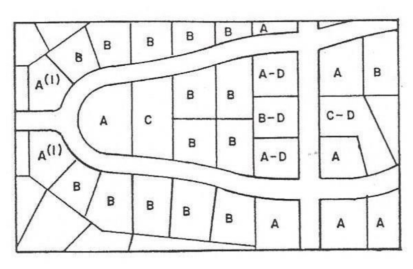
See Figure 1 (Attached)
Corner Lot (A). Defined as a lot located at the intersection of two or more streets. A lot abutting on a curved street or streets shall be considered a corner lot if straight lines drawn from the foremost points of the side lot lines to the foremost point of the lot meet at an interior angle of less than 135 degrees. See lots marked A (1) in the diagram.
Reversed Frontage Lot (D). Defined as a lot on which the frontage is at right angles or approximately right angles (interior angle less than 135 degrees) to the general pattern in the area. A reversed frontage lot may also be a corner lot (A-D in the diagram), an interior lot (B-D) or a through lot (C-D).
127 Maintenance and Repair (Estuarine Conservation Zone). Routine upkeep of an existing structure or remedial restoration of a damaged structure. Maintenance and repair may involve changes in the structure’s location, configuration, orientation, or alignment if these changes are limited to the minimum amount necessary to retain or restore its operation or function or to meet current building, engineering or safety standards.
128 Manufactured Dwelling Park. Any place where four or more manufactured dwellings are located within 500 feet of one another on a lot, tract or parcel of land under the same ownership, the primary purpose of which is to rent space or keep space for rent to any person for a charge or fee paid or to be paid for the rental or use of facilities or to offer space free in connection with securing the trade or patronage of such person. “Mobile home park” does not include a lot or lots located within a subdivision being rented or leased for occupancy by no more than one mobile home per lot if the subdivision was approved by the City of Gearhart.
129 Marina. Facilities which provide moorage, launching, storage and a variety of services for small craft.
130 Mean-High Water (MHW). The average height of the high tide waters over a 19-year period. The datum of MHW is the boundary between upland and tideland.
131 Mean-Low Water (MLW). The average height of the low tide waters over a 19-year period. The datum of MLW is the boundary between tideland and submerged land.
132 Mitigation. The creation, restoration, or enhancement of an estuarine area to maintain the functional characteristic and processes of the estuary, such as its natural biological productivity, habitats, and species, unique features and water quality.
135 Neighborhood. An area whose size is such that all parts are within walking distance of most residents and it is smaller than the total city area.
136 Neighborhood Café. Neighborhood Café, except for formula use as defined herein. A business devoted primarily to the serving of prepared food where food is consumed while customers are seated at tables and having no more than 1300 square feet of seating area. Food and beverage may also be sold for take-out. Service may include beer and wine sales on premise or to-go, where licensed by OLCC. Outdoor on-site seating is unlimited. Public sidewalk seating is permitted in accordance with safety and Neighborhood Grocery Market
137 Neighborhood Grocery Market A modern community market or co-op which sells food and sundries including produce, meats and seafood, beer and wine, personal and household items and other grocery items. May also include a deli, soups, salad bar, bakery, ice cream shop and made-to-order meals and beverages to go. May offer beer growlers to go, wine tasting and limited on premise beer & wine consumption where appropriate subject to OLCC licensing. Indoor seating limited to 700 square feet. Outdoor on-site seating is unlimited. Public sidewalk seating is permitted in accordance with safety and ADA requirement.
138 Nonconforming Structures or Use. A lawful existing structure or use at the time this ordinance or any amendments thereto becomes effective which does not conform to the requirements of the zone in which it is located.
139 Non-Public Recreational Activity. Golf courses, country clubs, swimming clubs, tennis clubs, or similar recreation uses that may or may not be open to the general public but excluding such commercial recreational uses as driving range, miniature golf course, amusement parks, or fitness centers.
140 Obstructed Street. A public or private street or driveway to multiple dwellings that has been obstructed by a gate or other barriers designed to restrict access.
141 Ocean Flooding. The flooding of lowland areas by saltwater owing to tidal action, storm surge, or tsunamis (seismic sea waves). Landforms subject to ocean flooding include beaches, marshes, coastal lowlands, and low-lying interdune areas. Areas of ocean flooding are mapped by the Federal Emergency Management Agency (FEMA). Ocean flooding includes areas of velocity flooding and associated shallow marine flooding.
142 Office (including banks, savings and loans, insurance and professional). A private commercial business enterprise which provides professional, administrative or related activities such as banking, insurance, medical and other professional services and management services.
143 Open Space. An unbuilt parcel of public or private land left uncovered by impervious surfaces.
144 Owner. An owner of property or the authorized agent of an owner.
145 Parking Space. An enclosed or unenclosed surfaced area permanently reserved for the temporary storage of one automobile and connected with a street or alley which affords ingress and egress for automobiles.
146 Permit. Discretionary approval of a proposed development of land under ORS 227.215.
147 Person. Every natural person, firm, partnership, association, social or fraternal organization, corporation, trust, estate, receiver, syndicate, branch of government, or any group or combination acting as a unit.
148 Piling. The driving of wood, concrete, or steel piling into the bottom in aquatic areas to support piers, bridges or other permitted uses.
149 Planter Strip. A landscape area for street trees and other plantings within the public right-of-way, usually a continuous planter area between the street and a sidewalk.
150 Private Swimming Pool (contiguous to a single-family dwelling which may be operated by a neighborhood group). A private facility providing for swimming and other water sport activities with accessory facilities such as dressing rooms.
151 Professional Office: A private business office providing medical and other professional services.
152 Public Access Easement. A public access easement is an easement granted to the public for vehicular and pedestrian access, or for non-motorized access.
153 Public Improvements. Development of public infrastructure, as required by the City, a special district, or road authority, as applicable.
154 Public Park and Recreation Facility. A public recreation facility which is owned by the municipality or other government agency.
155 Public Schools (primary, elementary, or high schools). Institutions which provide public education and related services which are operated by the local tax supported education district(s).
156 Public Service and Public Utility Use. A business or service, either governmental or regulated by the State which is engaged in supplying the public with a service such as electricity, gas, water, telephone, or communications.
157 Recreation. Any experience voluntarily engaged in largely during leisure (discretionary time) from which the individual derives satisfaction.
158 Recreation, Low Intensity. Does not require developed facilities and can be accommodated without change to the area or resource, e.g. boating, hunting, hiking, wildlife photography, and beach or shore activities can be low intensity recreation.
159 Recreation Vehicle. A registered and licensed trailer or other unit with or without motor power which is designed for human occupancy and to be used temporarily for recreation or emergency purposes. Recreational vehicles include camping trailers, motor homes, park trailers, bus conversions, van conversions, tent trailers, truck campers, boats with living quarters and any vehicle converted for use or partial use as a recreational vehicle. Except for a boat, the unit shall be identified as a recreational vehicle by the manufacturer.
160 Residential Home. A home licensed by or under the authority of the Department of Human Resources under ORS 443.400 to 443.825 which provides residential care alone or in conjunction with training or treatment or a combination thereof for five or fewer individuals who need not be related. Staff persons required to meet Department of Human Resources licensing requirements shall not be counted in the number of facility residents, and need not be related to each other or to any resident of the residential home.
161 Residential Facility. A facility licensed by or under the authority of the Department of Human Resources under ORS 443.460 which provides residential care alone or in conjunction with training or treatment or a combination thereof for six to fifteen individuals who need not be related. Staff persons required to meet Department of Human Resources licensing requirements shall not be counted in the number of facility residents, and need not be related to each other or to any resident of the residential facility.
162 Restaurant. A commercial establishment serving food and drink.
163 Restaurant (attached to a motel, hotel or tourist court). A commercial establishment serving food and drink designed to serve motel or hotel lodgers and other patrons.
164 Restoration. The replacing or restoring of original attributes or amenities such as natural biological productivity and aesthetic or cultural resources which have been diminished or lost by past alterations, activities or catastrophic events. For the purpose of Oregon Statewide Planning Goal 16, estuarine restoration means to revitalize or reestablish functional characteristics and processes of the estuary diminished or lost by past alterations, activities, or catastrophic events. A restored area must be a shallow subtidal or an intertidal or tidal marsh area after alteration work is performed and may not have been a functioning part of the estuarine system when alteration work began.
165 Restoration, Active. Involves the use of specific remedial actions such as removing dikes or fills, installing water treatment facilities, or rebuilding or removing deteriorated urban waterfront areas, or returning filled areas to tidal influence.
166 Restoration, Passive. The use of natural processes, sequences or timing to effect restoration after the removal or reduction of adverse stress.
167 Resource Enhancement. The use of artificial means such as hatcheries or rearing ponds to improve the quantity or quality of a specific resource.
168 Rezone: Process in which an amendment is initiated by a property owner, the City Planning Commission or the City Council (see Article 11, Amendments).
169 Riding Academy. A commercial establishment which provides horses for riding and has facilities for the care and training of horses.
170 Right-Of-Way. Real property or an interest in real property owned by a roadway authority for the purpose of constructing, operating, and maintaining public facilities.
171 Riparian. Pertaining to vegetation or habitat situated on the edge of the bank of a river or other body of water.
172 Riprap. A layer, facing, or protective mound of stones randomly placed to prevent erosion, scour or sloughing of a structure or embankment; also, the stone so used. In local usage, the similar use of other hard materials, such as concrete rubble, is also frequently included as riprap.
173 Roadway. The portion of a right-of-way that is improved for motor vehicle and bicycle travel, subject to applicable state motor vehicle licensing requirements. Roadway includes vehicle travel lanes and on-street parking areas. Roadway does not include area devoted to curbs, parking strips, or sidewalks.
174 Road/Roadway Authority. The City or other agency (e. g., Oregon Department of Transportation, City of Gearhart, or Clatsop County) with jurisdiction over a road or street.
175 Satellite Dish Receiving Antenna. A circular or parabolically shaped device of solid or mesh construction designed and erected for the purpose of receiving television or other telecommunications signals.
178 Shoreline. The boundary line between a body of water and the land nearest tidal water at mean high water and on non-tidal waterways at the ordinary high-water mark.
179 Shoreline Stabilization. The protection of the banks of a tidal or non-tidal stream, river or estuarine waters by vegetative or structural means.
180 Sidewalk. A paved walkway within a public street right-of-way that is generally located adjacent to and separated from the roadway by a curb, drainage facility (e.g., ditch or swale), or planter strip.
181 Sight Distance. The unobstructed viewing distance measured from one object or location to another object or location, usually required for the purpose of traffic safety (e.g., a length of street or highway that a driver can see with an acceptable level of clarity, pursuant to the standards of the applicable roadway authority).
182 Sign. An identification, description, illustration, or device which is affixed to or represented, directly or indirectly, upon a building, structure, or land, and which directs attention to a product, place, activity, person, institution, or business. Each display surface of a sign other than two surfaces parallel and back-to-back on the same structure shall be considered a sign.
183 Sign Area. The area of the smallest rectangle which can completely enclose a sign.
184 Sign, Permanent. A sign attached to a building, structure, or the ground in some manner or made of materials intended for more than short-term use.
185 Sign Requirements. Limitations on the types and size of signs as specified in Article 6, Section 6.020 Supplementary Provisions.
186 Sign, Temporary. A sign not permanently attached to a building, structure, or the ground. A temporary sign shall be displayed not more than 6 months in a 12-month period.
188 Small Wind Energy System. A wind energy conversion system consisting of a wind turbine, a support structure and associated control or conversion electronics that is intended to reduce on-site consumption of utility power.
189 Stabilization. The process of controlling sand activity (i.e., stilling the movement of sand) by natural vegetative growth, planting of grasses and shrubs, or mechanical means (e.g., wire net, fencing).
190 Story. That portion of a building included between the upper surface of any floor and the upper surface of the floor next above, except the topmost story shall be that portion of a building included between the upper surface of the top most floor and the ceiling or roof above.
191 Street. An officially approved public thoroughfare or right-of-way dedicated, established, deeded or condemned, 20 feet or greater in width, which provides for public use for the purpose of vehicular and pedestrian traffic and the placement of utilities and including the terms “road”, “highway”, “lane”, “place”, “avenue”, or other similar designation.
192 Structure. Anything constructed or installed or portable, the use of which requires a location on a parcel of land.
193 Structural Alteration. Any change to the supporting members of a building including foundation, bearing walls, or partition, columns, beams, or girders, or any structural change in the roof.
194 Submerged Lands. Lands below Mean Low Water; those normally covered by water.
195 Supplementary Provisions. Application of regulations governing site uses, design, access, and layout as required for all zone standards except for Residential-Commercial Planned Development and Floodplain Overlay Zones as specified in Articles 3, Article 5 and Article 6.
196 Temporary (Estuarine) Alteration. Dredging, filling, or other estuarine alteration occurring over a specified short period of time which is needed to facilitate an allowed use. Temporary alterations may not be for more than three years and the affected area must be restored to its previous condition. Temporary alterations include:1) alterations necessary for federally authorized navigation projects (e.g. access to dredged material disposal sites by barge or pipeline and staging areas or dredging for jetty maintenance), (2) alterations to establish mitigation sites, alterations for bridge construction or repair and for drilling or other exploratory operations, and (3) minor structures (such as blinds) necessary for research and educational observation.
197 Temporary Real Estate Office (located in a subdivision). A real estate office located temporarily in a subdivision where newly completed homes are for sale.
198 Theater. A commercial enterprise which has an indoor or outdoor facility for exhibiting motion picture shows or live stage shows.
199 Tidelands. See Submerged Lands.
200 Traffic Impact Analysis. A report prepared by a professional engineer that analyzes existing and future roadway conditions, and which may recommend transportation improvements and mitigation measures.
201 Triplex. See dwelling, Triplex.
202 Two-Family House. See Dwelling, Two-Family.
203 Use. The purpose for which land or a structure is designed, arranged, or intended, or for which it is occupied or maintained.
204 Vacation Rental Dwelling. Any Structure, or any portion of any structure, which is occupied or offered or designed for transient occupancy for less than 30 days for dwelling, lodging or sleeping purposes; and includes houses, cabins, condominiums, apartment units or other dwelling units, or portions of any of these dwelling units, that are used for temporary human occupancy, provided such occupancy is for less than a 30-day period.
205 Variance. A variance is a relaxation of the terms of the zoning ordinance where such variance will not be contrary to the public interest and where, owing to conditions peculiar to the property and not the result of the actions of the applicant, a literal enforcement of the ordinance would result in unnecessary and undue hardship. As used in this ordinance, a variance is authorized only for height, area and size of structure or size of yards and open spaces. Establishment or expansion of a use otherwise prohibited shall not be allowed by variance, nor shall a variance be granted because of the presence of non-conformities in the zoning district or uses in an adjoining zoning district.
206 Variety Store. A neighborhood or community retail store or gift shop selling a variety of household (including home & garden items, antiques) and personal use items including apparel. Limited food sales allowed for take-out, as long as it is not the primary business, including coffee/tea, baked goods made off premises, ice cream and similar items. Outdoor on-site seating is unlimited. Public sidewalk seating is permitted in accordance with safety and ADA requirements
207 Veterinary Complex. A commercial facility located at one location providing professional veterinary services.
208.Walkway. A sidewalk or path, including any access way, improved to City standards, or to other roadway authority standards, as applicable. See also, Shared-use Path and Sidewalk.
209 Warehouse. A building for storage of goods or merchandise.
210 Wetlands. Areas that are inundated or saturated by surface or ground water at a frequency and duration sufficient to support, and that under normal circumstances do support, a prevalence of vegetation typically adapted to life in saturated soil conditions.
211 Wholesale Distributors. A building in which goods or merchandise is stored and sold at a wholesale price level.
212 Yard. A required open space other than a court unoccupied and unobstructed by any structure or portion of a structure from 30 inches above the general ground level of the graded lot upward, provided however, that fences, walls, poles, posts and other customary yard accessories, ornaments, and furniture may be permitted in any yard subject to height limitations and requirements limit obstruction of visibility.
213 Yard, Back. An open unoccupied space on the same lot with the main building, between the rear line of the main building and the rear line of the lot.
214 Yard, Front. A yard extending between lot lines which intersect a street line, the depth of which is the minimum horizontal distance between the street line and a line parallel thereto on to a lot. In the case of through lots, unless the prevailing front yards pattern on adjoining lots indicates otherwise, front yards shall be provided on all frontages. In the case of corner lots as well as those with reversed frontage, a front yard of the required depth shall be provided in accordance with the ordinance along with required side yard depths on all other frontages. In the case of corner lots with more than two frontages, the building official shall determine which frontage shall be considered the front yard and which shall be considered side yards.
215 Yard, Side. A yard extending from the rear line of the required front yard to the rear lot line, or in the absence of any clearly defined rear lot line to the point on the lot farthest from the intersection of the lot line involved with the public street. In the case of through lots, side yards shall extend from the rear lines of front yards required. In the case of corner lots, yards remaining after full and half depth front yards have been established shall be considered side yards.
Article 2Basic Provisions
§ 2.012Classifications of Zones
For the purpose of the ordinance, the following zones are hereby established in the City of Gearhart:
§ 2.030Locations of Zones
The boundaries for the zones listed in this ordinance are indicated on a map entitled “Zone Map of Gearhart, Oregon,” which is hereby adopted by reference. The boundaries shall be modified in accordance with zoning map amendments which shall be adopted by reference.
§ 2.040Boundaries of Zones
§ 2.050Zoning Maps
The location and boundaries of the districts designated in Section 2.012 are established as shown on the map entitled “Zone Map of the City of Gearhart”, dated with the effective date of this amended ordinance codified herein, and signed by the Mayor and the City Administrator and referred to hereafter as the “zoning map”. The City Administrator shall amend the zoning map to reflect amendments adopted, thereto by ordinance by the City Council and list the Ordinance number.
§ 2.060Zoning of Annexed Areas
Areas annexed to the City shall automatically be designated as shown on the Comprehensive Plan/Zoning Map.
Article 3Listing of Outright or Conditional Uses Permitted in Residential and Commercial Zones
§ 3.005The Organization
This Article lists permitted outright uses, conditional uses, and standards for outright and conditional uses, and standards for outright and conditional uses for each designated zone. Zones are listed in the following order:
| Section | Designation | Page(s) |
|---|---|---|
| 3.0 | RA: Rural Agricultural Zone | RA-1 to RA-5 |
| 3.1 | R-1: Low-Density Residential Zone | R1-1 to R1-4 |
| 3.2 | R-2: Medium-Density Residential Zone | R2-1 to R2-3 |
| 3.3 | R-3: High-Density Residential Zone | R3-1 to R3-3 |
| 3.4 | C-1: Neighborhood Commercial Zone | C1-1 to C1-4 |
| 3.5 | C-2: General Commercial Zone | C2-1 to C2-4 |
| 3.6 | C-3: High Intensity Commercial Zone | C3-1 |
| 3.7 | RCPD: Residential – Commercial Planned Development Zone | RCPD-1 to RCPD-8 |
| 3.8 | P/SP: Public and Semi-Public Zone | P/SP-1 to P/SP-2 |
| 3.9 | P: Parks and Open Space | P1-1 to P1-2 |
| 3.10 | FHO: The Flood Hazard Overlay Zone | FHO-1 to FHO-29 |
| 3.11 | A-2: Aquatic Conservation Zone | A2-1 to A2-10 |
| 3.12 | BAD: Beaches and Active Dunes Overlay Zone | BAD-1 to BAD-11 |
| 3.13 | FWO: Freshwater Wetland and Lake Overlay Zone | FW-1 to FW-3 |
| 3.14 | THO: Tsunami Hazard Overlay Zone | THO-1 to THO-7 |
| 3.15 | AOD: Airport Overlay Zone | AO-1 to AO-7 |
Part 3.0Rural Agricultural Zone RA
§ 3.010Purpose
The purpose of the Rural Agricultural Zone, RA, is to create a semi-rural environment within the corporate limits of the City allowing the preservation and continuation of agricultural operations in conjunction with, or in close proximity to residential uses. It is a further intention that this zone would provide a transition between “rural” and “urban” areas.
§ 3.020Uses Permitted Outright
A permitted use is a use which is permitted outright subject to the applicable provisions of this code. If a use is not listed as a permitted use, it may be held to be a similar unlisted use under the provisions of Section 13.091.
In an RA zone, the following uses and their accessory uses are permitted outright subject to standards listed in Section 3.040.
Agricultural uses or any other enterprise customarily carried on in the field of general agriculture.
Home occupations (see Section 6.050).
Public service and public utility uses to serve the immediate area.
Manufactured dwelling in accordance with Section 6.100.
Manufactured dwelling, a recreational vehicle or a construction office used during the construction period of a permitted or conditional use for which a building permit has been issued, but not to exceed one year.
§ 3.030Conditional Uses Permitted
A conditional use is a use the approval of which is at the discretion of the Planning Commission as set forth in Article 8 Conditional Uses. If a use is not listed as a conditional use, it may be held to be a similar unlisted use under the provisions Section 13.091.
In an RA zone, the following uses and their accessory uses are permitted subject to the provisions of Article 8 and Standards listed in Section 3.040.
Church and other religious structures.
Primary, elementary, junior or senior high schools or a higher education institution.
Non-public recreational facilities.
Public Park and recreational facilities.
Public service and public utility use to service the entire city or other large geographic area.
Veterinary clinic with or without kennels.
Manufactured dwelling parks developed in accordance with Section 8.050(3).
Manufactured dwelling subdivisions in accordance with Section 8.050(4).
Temporary real estate office in a subdivision.
§ 3.035Prohibited Uses
A prohibited use is one which is expressly prohibited in the zone. In addition, uses not specifically listed as permitted or conditional in the zone, or deemed to be similar uses permitted to Section 13.091 are also prohibited.
The sale or holding out for sale or allowing others to sell or hold out for sale, more than (1) new or used vehicle, motor home, trailer, recreational vehicle, motorcycle, or boats at any one time on a tax lot.
Prohibited uses as defined in Section 3.14 Tsunami Hazard Overlay Zone.
§ 3.036Additional Use Restrictions
Development as defined in Section 1.030 #53 may be restricted by an overlay zone. A relevant overlay zone may include one or more as follows: Section 3.10 Flood Hazard Overlay Zone; Section 3.11 Aquatic Conservation Zone; 3.12 Beaches and Dunes Overlay Zone; Section 3.13 Freshwater Wetland and Lake Overlay Zone; Section 3.14 Tsunami Hazard Overlay Zone; Section 3.15 Airport Overlay Zone.
§ 3.040RA Zone Standards
In an RA zone, the following standards shall apply.
A front yard shall be at least 20 feet.
Off-street parking:
As specified in Section 6.060.
As specified in Section 6.020.
Public service and utility structures shall not include the stock piling or storage of materials.
§ 3.045General Exceptions to Lot Size Requirements
EXCEPTIONS TO STANDARDS
If a lot or the aggregate of contiguous lots in residential and commercial zones held in a single ownership are recorded in the office of the County Clerk at the time of the passage of Ordinance 477 (dated January 24, 1978) has an area or dimension which does not meet the respective lot size requirements, the holdings may be occupied by a use permitted in this zone subject to the other requirements of this zone, provided that, if there is an area deficiency, residential use shall be limited to a single-family dwelling. However, no dwelling shall be built on a lot with less area than 4,000 square feet. However, an owner is entitled to an exception only if his property is isolated. If the owner of an undersized holding owns another lot adjacent to it, he is not entitled to an exception. Rather, he must combine the two holdings to form one which will meet, or more closely approximate the area requirements of this ordinance.
§ 3.050General Exceptions to Yard Requirements
The following exception to the front yard requirements for a dwelling is authorized for a lot in any residential zone;
The required front yard for a dwelling need not exceed the average depth of the nearest front yard of a dwelling within 100 feet on either side of the proposed dwelling and the required front yard for the zone, provided the minimum depth shall not be less than eight (8) feet.
§ 3.055General Exceptions to Building Height Limitations
Projections such as chimneys, spires, domes, elevator shaft housings, towers, aerials, flagpoles, and other similar objects not used for human occupancy are not subject to the building height limitations of this ordinance.
§ 3.060Cluster Development Procedures
The intent of these standards is to preserve large parcels of land, and lands suitable for open space by providing an alternative to the division of rural lands into minimum lots allowed in the zone.
The Planning Commission shall cause a public hearing to be held according to Section 13.050.
The applicant for a cluster development must submit a development plan with State/Federal agencies approval on plat map. All required permits shall be attached to the plat plan. Conditional use approval and approval of the plan from the Planning Commission must be obtained prior to any development on the parcel.
As a condition to the approval that may be given for partitioning, the applicant shall provide copies of all deeds or contracts affecting the original R-A parcel to assure that the maximum density will not be exceeded.
For each partition or subdivision under this Standard the City Administrator or designate shall determine and include with the approved plan map a statement including:
The number of single-family home site lots allowed on the original parcel.
A legal description of the original parcel.
The number of single-family home site lots that will result from the proposed partition or subdivision, with a minimum of 10,000 square feet per home site.
The number of single-family home site lots, if any that could be allowed in the future on the original parcel
§ 3.070Residential Cluster Development Standards
The tract of land to be developed shall not be less than 4 contiguous acres in size, provided that land divided by a road shall be deemed to be contiguous.
The development may have a density not to exceed the equivalent of the number of dwelling units allowed per acre in the zone.
The cluster development shall not contain commercial or industrial developments.
The minimum percentage of common open space shall be 40% excluding roads and property under water (designated wetlands, rivers, streams, lakes, drainage ditches, etc.). Open space use will be with approval of Planning Commission.
Streams, wetlands and drainage areas shall be preserved.
Part 3.1Low Density Residential Zone R-1
§ 3.110Purpose
The purpose of the Low Density Residential Zone, R-1, is to provide for low density single-family development with a maximum density of four dwelling units per acre. These areas are characterized by residential qualities and provide for other uses which are consistent with residential neighborhoods such as churches, schools and community uses.
§ 3.120Outright Uses Permitted
A permitted use is a use which is permitted outright subject to the applicable provisions of this code. If a use is not listed as a permitted use, it may be held to be a similar unlisted use under the provisions of Section 13.091.
In an R-1 Zone the following uses and their accessory uses are permitted outright.
Public service and public utility use to service the immediate area.
Home occupations (see Section 6.050).
Manufactured dwelling in accordance with Section 6.100.
Manufactured dwelling, recreation vehicle or a construction office used during the construction period of a permitted or conditional use for which a building permit has been issued, but not to exceed one year.
§ 3.130Conditional Uses Permitted
A conditional use is a use the approval of which is at the discretion of the Planning Commission as set forth in Article 8 Conditional Uses. If a use is not listed as a conditional use, it may be held to be a similar unlisted use under the provisions of Section 13.091.
In an R-1 Zone the following conditional uses and their accessory uses are permitted subject to the provisions of Article 8 and standards in Section 3.140.
Church and other religious structures
Primary, elementary, junior, or senior high schools; or a high education institution
Golf Course, except commercial driving ranges or miniature course
Temporary real estate office in a subdivision
Public service and public utility use to serve the entire city or other large geographic area
§ 3.135Prohibited Uses
A prohibited use is one which is expressly prohibited in the zone. In addition, uses not specifically listed as permitted or conditional in the zone, or deemed to be similar uses permitted to Section 13.091 are also prohibited.
The sale or holding out for sale or allowing others to sell or hold out for sale, more than (1) new or used vehicle, motor home, trailer, recreational vehicle, motorcycle, or boats at any one time on a tax lot.¹
Prohibited uses as defined in Section 3.14 Tsunami Hazard Overlay Zone
§ 3.136Additional Use Restrictions
Development as defined in Section 1.030 #53 may be restricted by an overlay zone. A relevant overlay zone may include one or more as follows: Section 3.10 Flood Hazard Overlay Zone; Section 3.11 Aquatic Conservation Zone; 3.12 Beaches and Dunes Overlay Zone; Section 3.13 Freshwater Wetland and Lake Overlay Zone; Section 3.14 Tsunami Hazard Overlay Zone; Section 3.15 Airport Overlay Zone.
§ 3.140R-1 Zone Standards
In an R-1 Zone the following standards shall apply.
Density:
The overall density on any parcel shall not exceed 4 dwelling units per net acre.
A front yard shall be at least 15 feet.
A side yard shall be at least 5 feet on one side and 9 feet on the other, except where the on-site waste disposal facility is accessible from a right of way or easement (then 5 feet both side yards). Except on corner lots a yard abutting the side street shall be at least 10 feet.
Off street parking:
As specified in Section 6.060, Off Street Parking Requirements.
Transportation Improvements:
As specified in Article 4, Transportation Improvements and Access Management.
As specified in Section 6.020, Sign Requirements.
Necanicum River Estuary setback:
All structures and uses shall be setback fifty feet (50) from the Necanicum River Estuary, unless direct water access is required in conjunction with a water dependent use. The setback shall be measured from the mean high-water line. Riparian vegetation within this setback shall be protected as specified in Section 6.070(5).
Neacoxie Creek Setback:
All structures and uses shall be setback fifty (50) feet from Neacoxie Creek, unless direct water access is required in conjunction with a water dependent use. The setback shall be measured from the ordinary high waterline. Riparian vegetation within this setback shall be protected as specified in Section 6.070(5).
§ 3.145General Exceptions to Lot Size Requirements
EXCEPTIONS TO STANDARDS
If a lot or the aggregate of contiguous lots in residential and commercial zones held in a single ownership are recorded in the office of the County Clerk at the time of the passage of Ordinance 477 (dated January 24, 1978) has an area or dimension which does not meet the respective lot size requirements, the holdings may be occupied by a use permitted in this zone subject to the other requirements of this zone, provided that, if there is an area deficiency, residential use shall be limited to a single-family dwelling. However, no dwelling shall be built on a lot with less area than 4,000 square feet. However, an owner is entitled to an exception only if his property is isolated. If the owner of an undersized holding owns another lot adjacent to it, he is not entitled to an exception. Rather, he must combine the two holdings to form one which will meet, or more closely approximate the area requirements of this ordinance.
§ 3.150General Exceptions to Yard Requirements
The following exception to the front yard requirements for a dwelling is authorized for a lot in any residential zone;
The required front yard for a dwelling need not exceed the average depth of the nearest front yard of a dwelling within 100 feet on either side of the proposed dwelling and the required front yard for the zone, provided the minimum depth shall not be less than eight (8) feet.
§ 3.155General Exceptions to Building Height Limitations
Projections such as chimneys, spires, domes, elevator shaft housings, towers, aerials, flagpoles, and other similar objects not used for human occupancy are not subject to the building height limitations of this ordinance
Part 3.2Medium Density Residential R-2
§ 3.210Purpose
The purpose of the R-2 Medium Density Residential Zone is to provide housing consisting of a mixture of single family, multiple family house. The maximum allowable density shall be six (6) dwelling units per acre.
§ 3.220Outright Uses Permitted
A permitted use is a use which is permitted outright subject to the applicable provisions of this code. If a use is not listed as a permitted use, it may be held to be a similar unlisted use under the provisions of Section 13.091.
In an R-2 Zone the following uses and their accessory uses are permitted outright.
Two-family dwelling or duplex.
Triplex or Fourplex.
Home occupations (See Section 6.050).
Manufactured dwelling in accordance with Section 6.100.
Manufactured dwelling, recreation vehicle, or construction office used during the construction period of a permitted or conditional use for which a building permit has been issued but not to exceed one year.
§ 3.230Conditional Uses Permitted
A conditional use is a use the approval of which is at the discretion of the Planning Commission as set forth in Article 8 Conditional Uses. If a use is not listed as a conditional use, it may be held to be a similar unlisted use under the provisions of Section 13.091.
In an R-2 Zone the following conditional uses and their accessory uses are permitted subject to the provisions of Article 8 and standards in Section 3.240.
Conditional use permitted in an R-1 Zone.
Manufactured Dwelling Subdivision.
A hotel legally established prior to the adoption of the Zoning Ordinance of October 1994 (October 11, 1994) shall be considered a conditional use. A hotel may continue even if it is nonconforming with respect to the standards of Section 3.240, provided it does not increase the degree of nonconformity. If such use is discontinued for a period of one year it may be reestablished upon approval of a new Conditional Use Permit."
§ 3.235Prohibited Uses
A prohibited use is one which is expressly prohibited in the zone. In addition, uses not specifically listed as permitted or conditional in the zone, or deemed to be similar uses permitted to Section 13.091 are also prohibited.
The sale or holding out for sale or allowing others to sell or hold out for sale, more than (1) new or used vehicle, motor home, trailer, recreational vehicle, motorcycle, or boats at any one time on a tax lot.¹
Prohibited uses as defined in Section 3.14 Tsunami Hazard Overlay Zone
§ 3.236Additional Use Restrictions
Development as defined in Section 1.030 #53 may be restricted by an overlay zone. A relevant overlay zone may include one or more as follows: Section 3.10 Flood Hazard Overlay Zone; Section 3.11 Aquatic Conservation Zone; 3.12 Beaches and Dunes Overlay Zone; Section 3.13 Freshwater Wetland and Lake Overlay Zone; Section 3.14 Tsunami Hazard Overlay Zone; Section 3.15 Airport Overlay Zone.
§ 3.240R-2 Zone Standards
In an R-2 Zone the following standards shall apply.
A front yard shall be at least 15 feet.
A side yard shall be at least 5 feet on one side and 9 feet on the other, except where the on-site waste disposal facility is accessible from a right-of-way or easement (then 5 feet both side yards). Except on corner lots a side yard abutting the side street shall be at least 10 feet.
Height restriction:
Maximum height of a structure shall be 30 feet.
Off street parking
As specified in Section 6.060, Off Street Parking Requirements.
Transportation Improvements
As specified in Article 4, Transportation Improvements and Access Management.
As specified in Section 6.020, Sign Requirements.
Neacoxie Creek Setback:
All structures and uses shall be setback fifty (50) feet from Neacoxie Creek unless direct water access is required in conjunction with a water dependent use. The setback shall be measured from the mean higher water line on estuarine portions and the line of ordinary high water for non-estuarine portions of the creek. Riparian vegetation within the setback shall be protected as specified by Section 6.070(5).
Buffer Requirements:
The sand dune ridge located adjacent to the improved portion west of Railroad Avenue shall be maintained. This ridge shall not be breached or reduced in size.
§ 3.245General Exceptions to Lot Size Requirements
EXCEPTIONS TO STANDARDS
If a lot or the aggregate of contiguous lots in residential and commercial zones held in a single ownership are recorded in the office of the County Clerk at the time of the passage of Ordinance 477 (dated January 24, 1978) has an area or dimension which does not meet the respective lot size requirements, the holdings may be occupied by a use permitted or conditionally permitted in this zone subject to the other requirements of this zone, provided that, if there is an area deficiency, residential use shall be limited to a single-family dwelling. However, no dwelling shall be built on a lot with less area than 4,000 square feet. However, an owner is entitled to an exception only if his property is isolated. If the owner of an undersized holding owns another lot adjacent to it, he is not entitled to an exception. Rather, he must combine the two holdings to form one which will meet, or more closely approximate the area requirements of this ordinance.
§ 3.250General Exceptions to Yard Requirements
The following exception to the front yard requirements for a dwelling is authorized for a lot in any residential zone:
The required front yard for a dwelling need not exceed the average depth of the nearest front yard of a dwelling within 100 feet on either side of the proposed dwelling and the required front yard for the zone, provided the minimum depth shall not be less than eight (8) feet.
§ 3.255General Exceptions to Building Height Limitations
Projections such as chimneys, spires, domes, elevator shaft housings, towers, aerials, flagpoles, and other similar objects not used for human occupancy are not subject to the building height limitations of this ordinance
Part 3.3R-3: High Density Residential Zone
§ 3.310Purpose
The purpose of the R-3, High Density Residential Zone, is to provide for high density multi-family development with a maximum density of 16 dwelling units per net acre. Also, to provide space for the orderly development and expansion of overnight accommodations and related business such as gift shops. Other uses such as churches, parks, government buildings, and utilities are provided for in this zone. Conversion to resort uses should be provided with a minimum of disruption of existing residential values.
§ 3.320Outright Uses Permitted
A permitted use is a use which is permitted outright subject to the applicable provisions of this code. If a use is not listed as a permitted use, it may be held to be a similar unlisted use under the provisions of Section 13.091.
In an R-3 Zone the following uses and their accessory uses are permitted outright.
A use permitted outright within the R-2 Zone.
Multifamily dwelling.
Home Occupations (see Section 6.050).
Manufactured dwellings in accordance with Section 6.100.
Manufactured dwelling, recreation vehicle or a construction office used during the construction period of a permitted or conditional use for which a building permit has been issued, but not to exceed on year.
§ 3.330Conditional Uses Permitted
A conditional use is a use the approval of which is at the discretion of the Planning Commission as set forth in Article 8 Conditional Uses. If a use is not listed as a conditional use, it may be held to be a similar unlisted use under the provisions of Section 13.091.
In an R-3 Zone the following conditional uses and their accessory uses are permitted subject to the provisions of Article 8 and standards in Section 3.340.
Church and other religious structures.
Motel, hotel, and other tourist accommodations.
Non-public recreation facility.
Public service and public utility use to serve the entire city or other large geographic area.
Restaurant, cocktail lounge, gift shop, or other uses appropriate to motel or hotel.
§ 3.335Prohibited Uses
A prohibited use is one which is expressly prohibited in the zone. In addition, uses not specifically listed as permitted or conditional in the zone, or deemed to be similar uses permitted to Section 13.091 are also prohibited.
The sale or holding out for sale or allowing others to sell or hold out for sale, more than (1) new or used vehicle, motor home, trailer, recreational vehicle, motorcycle, or boats at any one time on a tax lot.¹
Prohibited uses as defined in Section 3.14 Tsunami Hazard Overlay Zone
§ 3.336Additional Use Restrictions
Development as defined in Section 1.030 #53 may be restricted by an overlay zone. A relevant overlay zone may include one or more as follows: Section 3.10 Flood Hazard Overlay Zone; Section 3.11 Aquatic Conservation Zone; 3.12 Beaches and Dunes Overlay Zone; Section 3.13 Freshwater Wetland and Lake Overlay Zone; Section 3.14 Tsunami Hazard Overlay Zone; Section 3.15 Airport Overlay Zone.
§ 3.340R-3 Zone Standards
In an R-3 Zone the following standards shall apply.
Lot size:
Lot area shall be a minimum of 5,000 square feet. The minimum lot size for single family dwelling is 5,000 square feet; duplex, 7,500 square feet; multi family dwelling, 5,000 square feet for the first unit and 2,500 square feet for each additional unit.
Density:
The overall density on any parcel shall not exceed 16 dwelling units per net acre.
A front yard shall be at least 15 feet.
A side yard shall be at least 10 feet, except on corner lots a side yard abutting the side street shall be at least 15 feet. Side yards shall be increased to 15 feet for structures more than 2 stories in height.
Rear yard:
A rear yard shall be at least 15 feet. Rear yards shall be increased to 25 feet for structures more than 2 stories in height.
Off-street parking:
As specified in Section 6.060.
Transportation Improvements:
As specified in Article 4, Transportation Improvements and Access Management.
As specified in Section 6.020.
§ 3.345General Exceptions to Lot Size Requirements
EXCEPTIONS TO STANDARDS
If a lot or the aggregate of contiguous lots in residential and commercial zones held in a single ownership are recorded in the office of the County Clerk at the time of the passage of Ordinance 477 (dated January 24, 1978) has an area or dimension which does not meet the respective lot size requirements, the holdings may be occupied by a use permitted in this zone subject to the other requirements of this zone, provided that, if there is an area deficiency, residential use shall be limited to a single-family dwelling. However, no dwelling shall be built on a lot with less area than 4,000 square feet. However, an owner is entitled to an exception only if his property is isolated. If the owner of an undersized holding owns another lot adjacent to it, he is not entitled to an exception. Rather, he must combine the two holdings to form one which will meet, or more closely approximate the area requirements of this ordinance.
§ 3.350General Exceptions to Yard Requirements
The following exception to the front yard requirements for a dwelling is authorized for a lot in any residential zone;
The required front yard for a dwelling need not exceed the average depth of the nearest front yard of a dwelling within 100 feet on either side of the proposed dwelling and the required front yard for the zone, provided the minimum depth shall not be less than eight (8) feet.
§ 3.355General Exceptions to Building Height Limitations
Projections such as chimneys, spires, domes, elevator shaft housings, towers, aerials, flagpoles, and other similar objects not used for human occupancy are not subject to the building height limitations of this ordinance
Part 3.4C-1: Neighborhood Commercial Zone
§ 3.410Purpose
To provide for the location of needed small businesses and services in the City Center for the convenience of nearby residents. Businesses are intended to fit into the residential character of the neighborhood and not create either architectural or traffic conflicts.
§ 3.420Outright Uses Permitted
A permitted use is a use which is permitted outright subject to the applicable provisions of this code. If a use is not listed as a permitted use, it may be held to be a similar unlisted use under the provisions of Section 13.091.
In a C-1 Zone the following uses and their accessory uses are permitted outright.
A modern community market or co-op which sells food and sundries including produce, meats and seafood, beer and wine, personal and household items and other grocery items. May also include a deli, soups, salad bar, bakery, ice cream shop and made-to-order meals and beverages to go. May offer beer growlers to go, wine tasting and limited on premise beer & wine consumption where appropriate subject to OLCC licensing. Indoor seating limited to 700 square feet. Outdoor on-site seating is unlimited. Public sidewalk seating is permitted in accordance with safety and ADA requirements.
Barber, Salon and Spa Services
Arts and Crafts Gallery and Studio
A retail store which primarily sells and displays art and arts and craft supplies. May include space for art classes and space for artists to work.
Government facility limited to a post office.
Manufactured dwelling, recreation vehicle or construction office used during the construction period of a permitted or conditional use for which a building permit has been issued, but not to exceed one year.
§ 3.430Conditional Uses Permitted
A conditional use is a use the approval of which is at the discretion of the Planning Commission as set forth in Article 8 Conditional Uses. If a use is not listed as a conditional use, it may be held to be a similar unlisted use under the provisions of Section 13.091.
In a C-1 Zone the following conditional uses and their accessory uses are permitted subject to the provisions of Article 8 CUP and standards in Section 3.440.
Neighborhood Café, except for formula use as defined herein. A business devoted primarily to the serving of prepared food where food is consumed while customers are seated at tables and having no more than 1300 square feet of seating area. Food and beverage may also be sold for take-out. Service may include beer and wine sales on premise or to-go, where licensed by OLCC. Outdoor on-site seating is unlimited. Public sidewalk seating is permitted in accordance with safety and ADA requirements.
A neighborhood or community retail store or gift shop selling a variety of household (including home & garden items, antiques) and personal use items including apparel. Limited food sales allowed for take-out, as long as it is not the primary business, including coffee/tea, baked goods made off premises, ice cream and similar items. Outdoor on-site seating is unlimited. Public sidewalk seating is permitted in accordance with safety and ADA requirements.
A residential use is permitted in conjunction with a permitted use where the residential use does not exceed fifty percent (50%) of the building’s total floor area.
§ 3.435Prohibited Uses
A prohibited use is one which is expressly prohibited in the zone. In addition, uses not specifically listed as permitted or conditional in the zone, or deemed to be similar uses permitted to Section 13.091 are also prohibited.
The sale or holding out for sale or allowing others to sell or hold out for sale, more than (1) new or used vehicle, motor home, trailer, recreational vehicle, motorcycle, or boats at any one time on a tax lot.¹
Prohibited uses as defined in Section 3.14 Tsunami Hazard Overlay Zone.
Amusement parks, arcades or surrey-style bicycle rentals.
Formula use, drive-in restaurant, mobile food vending wagon or other drive-in facilities such as a car wash. Formula Use definition: Any restaurant, bar and entertainment use and retail use that has four (4) or more other establishments in operation, or with local land use or permit entitlements already approved and effective, located anywhere in the United States. In addition to the four (4) establishments either in operation or with local land use or permit entitlements approved for operation, the business maintains two (2) or more of the following features: a standardized façade, a standardized array of merchandise, standardized array of services, a standardized décor and color scheme, uniform apparel, a standardized sign, a trademark or a service mark.
Private parking lot
Manufactured facilities: part of a business in conjunction with a permitted use where the creation of products on-site through industrialized processes takes place that may have an impact on local utilities and the neighborhood in general including fermentation, distilling and fabrication.
Adult shops
§ 3.436Additional Use Restrictions
Development as defined in Section 1.030 #53 may be restricted by an overlay zone. A relevant overlay zone may include one or more as follows: Section 3.10 Flood Hazard Overlay Zone; Section 3.11 Aquatic Conservation Zone; 3.12 Beaches and Dunes Overlay Zone; Section 3.13 Freshwater Wetland and Lake Overlay Zone; Section 3.14 Tsunami Hazard Overlay Zone; Section 3.15 Airport Overlay Zone.
§ 3.440C-1 Zone Standards
In a C-1 Zone the following standards shall apply.
Residential uses:
Except for a residential use approved as a part of a commercial use, residential uses are subject to applicable section 3.1 R-1 Zone Standards except:
The minimum lot size can be 5,000 square feet, and
Where property owners offer joint easement of 25-foot side yards for accessibility to on site waste disposal facilities.
Commercial Uses shall include the following lot development standards:
No lot size minimum
No lot coverage maximum
No minimum or maximum residential density
No front yard setback minimum
No side yard setback minimum except when adjoining a residential zone, then the setback is 5 feet.
A rear yard setback shall be at least 5 feet.
Building height shall be 30’ or two stories, whichever is less.
Transportation Improvements as specified in Article 4.
Sign requirements in accordance with Section 6.020.
§ 3.445General Exceptions to Lot Size Requirements
EXCEPTIONS TO STANDARDS
If a lot or the aggregate of contiguous lots in residential and commercial zones held in a single ownership are recorded in the office of the County Clerk at the time of the passage of Ordinance 477 (dated January 24, 1978) has an area or dimension which does not meet the respective lot size requirements, the holdings may be occupied by a use permitted in this zone subject to the other requirements of this zone, provided that, if there is an area deficiency, residential use shall be limited to a single-family dwelling. However, no dwelling shall be built on a lot with less area than 4,000 square feet. However, an owner is entitled to an exception only if his property is isolated. If the owner of an undersized holding owns another lot adjacent to it, he is not entitled to an exception. Rather, he must combine the two holdings to form one which will meet, or more closely approximate the area requirements of this ordinance.
§ 3.455General Exceptions to Building Height Limitations
Projections such as chimneys, spires, domes, elevator shaft housings, towers, aerials, flagpoles, and other similar objects not used for human occupancy are not subject to the building height limitations of this ordinance.
Part 3.5C-2: General Commercial Zone
§ 3.510Purpose
The purpose of the C-2 General Commercial Zone is to provide for a broad range of commercial uses and activities to serve the needs of the City and its visitors. The General Commercial Zone shall provide for a broader range of commercial development than may be located in the C-1 zone.
§ 3.520Outright Uses Permitted
A permitted use is a use which is permitted outright subject to the applicable provisions of this code. If a use is not listed as a permitted use, it may be held to be a similar unlisted use under the provisions of Section 13.091.
In a C-2 Zone the following uses and their accessory uses are permitted outright.
An outright or conditional use in the C-1Zone.
Personal business service establishments such as barber or beauty shop, clothes cleaning or funeral home.
Professional, financial, business and medical offices.
Retail business establishments excluding new and used car, boat, recreational vehicle or manufactured dwelling sale.
Technical, professional, vocational and business schools.
Membership organizations such as union, lodge hall, club or fraternal buildings.
Eating and drinking establishments.
Automobile repair establishment.
Cabinet, carpenter, woodwork, sheet metal shops or similar establishments.
Mini-storage warehouses or similar storage areas.
Wholesale storage and distribution facilities including cold storage.
Non-public recreation facilities.
Veterinary hospital: including grooming and in-facility boarding, with no outside kennels.
Feed Store/Garden Center.
Single family dwelling, duplex, or Manufactured Dwelling in accordance with Section 6.100.
Home occupation (see Section 6.050).
Residential home and Residential care facility.
Manufactured dwelling, recreation vehicle or a construction office used during the construction period of a permitted or conditional use for which a building permit has been issue, but not to exceed one year.
Medical or Marijuana and Marijuana Infused Product Dispensary subject to:
Dispensary must not be located within 1,000 feet of another marijuana dispensary nor within 1,000 feet of real property of a public or private elementary, secondary or career school, an established day care or preschool; nor student training facility such as a dance studio, athlete, music and similar training facilities; nor public recreation facilities attended primarily by minors. (“Within 1,000 feet” means a straight-line measurement in a radius extended for 1,000 feet or less in every direction from a specified location or from any point on the boundary line of a specified unit of property)
Dispensary must be authorized in accordance with ORS 475.314 and licensed by the Oregon Liquor Control Commission OLCC.
Pawn Shop.
§ 3.530Conditional Uses Permitted
A conditional use is a use the approval of which is at the discretion of the Planning Commission as set forth in Article 8 Conditional Uses. If a use is not listed as a conditional use, it may be held to be a similar unlisted use under the provisions of Section 13.091.
In a C-2 Zone the following conditional uses and their accessory uses are permitted subject to the provisions of Article 8 and standards in Section 3.540.
Church or other religious structures.
Amusement enterprises such as theater or bowling alley.
Commercial recreation such as driving range or miniature golf course.
Primary, elementary, junior or senior high schools; or a higher education institution.
Hospital, sanitarium, rest home, nursing or convalescent home.
Hotel, motel or other tourist accommodations.
Triplex or multi family dwelling.
§ 3.535Prohibited Uses
A prohibited use is one which is expressly prohibited in the zone. In addition, uses not specifically listed as permitted or conditional in the zone, or deemed to be similar uses permitted to Section 13.091 are also prohibited.
The sale or holding out for sale or allowing others to sell or hold out for sale, more than (1) new or used vehicle, motor home, trailer, recreational vehicle, motorcycle, or boats at any one time on a tax lot.¹
Prohibited uses as defined in Section 3.14 Tsunami Hazard Overlay Zone.
§ 3.536Additional Use Restrictions
Development as defined in Section 1.030 #53 may be restricted by an overlay zone. A relevant overlay zone may include one or more as follows: Section 3.10 Flood Hazard Overlay Zone; Section 3.11 Aquatic Conservation Zone; 3.12 Beaches and Dunes Overlay Zone; Section 3.13 Freshwater Wetland and Lake Overlay Zone; Section 3.14 Tsunami Hazard Overlay Zone; Section 3.15 Airport Overlay Zone.
§ 3.540C-2 Zone Standards
In a C-2 Zone the following standards shall apply.
Lot:
No minimum requirements.
Minimum of 25 feet.
Height restriction:
Maximum height of a structure shall be 30 feet.
No requirements except for a residential dwelling for which the lot coverage is the same as in an R-3 Zone.
Off-street parking:
As specified in Section 6.060.
Transportation Improvements. As specified in Article 4, Transportation Improvements and Access Management.
As specified in Section 6.020.
Buffer Requirements:
The sand dune ridge located to the west of the improved portion of Railroad Avenue shall be maintained. This ridge shall not be breached or reduced in size.
Where a yard required in Section 3.540(2) – 3.540(4) abuts a residential zone, the required yard shall contain: a dense evergreen planting which attains a mature height of at least eight (8) feet, a six-foot fence made of wood, or a combination of evergreen plantings and fencing
§ 3.545General Exceptions to Lot Size Requirements
EXCEPTIONS TO STANDARDS
If a lot or the aggregate of contiguous lots in residential and commercial zones held in a single ownership are recorded in the office of the County Clerk at the time of the passage of Ordinance 477 (dated January 24, 1978) has an area or dimension which does not meet the respective lot size requirements, the holdings may be occupied by a use permitted in this zone subject to the other requirements of this zone, provided that, if there is an area deficiency, residential use shall be limited to a single-family dwelling. However, no dwelling shall be built on a lot with less area than 4,000 square feet. However, an owner is entitled to an exception only if his property is isolated. If the owner of an undersized holding owns another lot adjacent to it, he is not entitled to an exception. Rather, he must combine the two holdings to form one which will meet, or more closely approximate the area requirements of this ordinance.
§ 3.555General Exceptions to Building Height Limitations
Projections such as chimneys, spires, domes, elevator shaft housings, towers, aerials, flagpoles, and other similar objects not used for human occupancy are not subject to the building height limitations of this ordinance.
Part 3.6C-3: Higher Intensity Commercial Zone
§ 3.610Purpose
The purpose of the C-3 Higher Intensity Commercial Zone is to provide an area for the most intensive commercial uses.
§ 3.620Outright Uses Permitted
A permitted use is a use which is permitted outright subject to the applicable provisions of this code. If a use is not listed as a permitted use, it may be held to be a similar unlisted use under the provisions of Section 13.091.
In a C-3 Zone the following uses and their accessory uses are permitted outright.
Contractor equipment storage yards or storage, rental and maintenance of equipment commonly used by a contractor.
Mini-storage warehouses or similar storage areas.
Wholesale storage and distribution facilities including cold storage.
Manufactured dwelling, recreation vehicle or a construction office used during the construction period of a permitted or conditional use for which a building permit has been issued, but not to exceed one year.
§ 3.635Prohibited Uses
A prohibited use is one which is expressly prohibited in the zone. In addition, uses not specifically listed as permitted or conditional in the zone, or deemed to be similar uses permitted to Section 13.091 are also prohibited.
The sale or holding out for sale or allowing others to sell or hold out for sale, more than (1) new or used vehicle, motor home, trailer, recreational vehicle, motorcycle, or boats at any one time on a tax lot.¹
Prohibited uses as defined in Section 3.14 Tsunami Hazard Overlay Zone.
§ 3.636Additional Use Restrictions
Development as defined in Section 1.030 #53 may be restricted by an overlay zone. A relevant overlay zone may include one or more as follows: Section 3.10 Flood Hazard Overlay Zone; Section 3.11 Aquatic Conservation Zone; 3.12 Beaches and Dunes Overlay Zone; Section 3.13 Freshwater Wetland and Lake Overlay Zone; Section 3.14 Tsunami Hazard Overlay Zone; Section 3.15 Airport Overlay Zone.
§ 3.640C-3 Zone Standards
Part 3.7RCPD: Residential Commercial Planned Development Zone
§ 3.710Purpose
The purpose of the RCPD Residential Commercial Planned Development Zone is to:
Permit greater flexibility in site design than is possible through the application of conventional zoning regulations.
Encourage site design that presents and/or takes advantage of existing natural features such as vegetation, slope, wetlands, geologic features and drainage areas.
Permits a greater variety of housing types within a given site where such development is compatible with the surrounding land use pattern.
Provide for a mixture of residential and commercial uses on a given site where such development is compatible with the surrounding land use pattern and where the commercial use is designed to primarily serve the residential portion of the development; and
Encourage the provision of recreation facilities and other common facilities.
§ 3.720Outright Uses Permitted
A permitted use is a use which is permitted outright subject to the applicable provisions of this code. If a use is not listed as a permitted use, it may be held to be a similar unlisted use under the provisions of Section 13.091.
Temporary post-disaster shelters, debris storage, and heavy equipment storage
§ 3.730Conditional Uses Permitted
A conditional use is a use the approval of which is at the discretion of the Planning Commission as set forth in Article 8 Conditional Uses. If a use is not listed as a conditional use, it may be held to be a similar unlisted use under the provisions of Section 13.091.
In an RCPD zone, the following conditional uses and their accessory uses are permitted subject to the standards in Section 3.740 and the procedures of Section 3.750.
Manufactured dwelling subdivision or park
Two-family dwellings or duplex.
Triplex or Fourplex.
Multi-family dwelling.
Commercial uses that are primarily intended to serve Gearhart’s residential component. These uses are retail food and drug store, neighborhood café, personal service establishments such as clothes cleaning or beauty shop.
§ 3.735Prohibited Uses
A prohibited use is one which is expressly prohibited in the zone. In addition, uses not specifically listed as permitted or conditional in the zone, or deemed to be similar uses permitted to Section 13.091 are also prohibited.
The sale or holding out for sale or allowing others to sell or hold out for sale, more than (1) new or used vehicle, motor home, trailer, recreational vehicle, motorcycle, or boats at any one time on a tax lot.¹
Prohibited uses as defined in Section 3.14 Tsunami Hazard Overlay Zone.
§ 3.736Additional Use Restrictions
Development as defined in Section 1.030 #53 may be restricted by an overlay zone. A relevant overlay zone may include one or more as follows: Section 3.10 Flood Hazard Overlay Zone; Section 3.11 Aquatic Conservation Zone; 3.12 Beaches and Dunes Overlay Zone; Section 3.13 Freshwater Wetland and Lake Overlay Zone; Section 3.14 Tsunami Hazard Overlay Zone; Section 3.15 Airport Overlay Zone.
§ 3.740RCPD Zone Standards
In an RCPD zone, the following standards shall apply.
Residential Density:
Densities will not exceed the level which the Planning Commission determines are appropriate for the development due to natural features of the area, public facility requirements, and compatibility with nearby development. The density of the portion of the parcel of land reserved for residential use shall not exceed 16 dwelling units per net acre. In no case will the density of mobile home developments be less than 4.36 D.U. /net acre, unless there is a public facility constraint.
Minimum lot size, lot depth, lot width, yard and lot coverage requirements:
None
In all residential developments, or in combination residential commercial developments, 40% of the total land area shall be devoted to open space. Of this area, 25% of said open space may be utilized privately by individual owners or uses of the development; however, 75% of this area shall be common open space.
No area may be accepted as common open space within a development unless it meets the following requirements.
The location, shape, size and character of the common open space are suitable for the development.
The common open space is for amenity or recreational purposes and the uses authorized are appropriate to the scale and character of the development based on consideration of its size, density, expected population, topography and the number and type of dwellings provided.
The common open space will be suitably improved for its intended use, except the common open space containing natural features worthy of preservation may be left unimproved. The buildings, structures, and improvements to be permitted in the common open space are appropriate to the uses which are authorized for the common open space.
No parking facilities will be included in areas designed as common open space unless the parking facilities are intended to provide access to common open space area and are not intended to meet the ordinance requirements for other uses.
The development schedule which is part of the development plan coordinates the improvement of the common open space and the construction of buildings and other structures in the common open space with the construction of residential dwellings in the development.
If the buildings or structures are made in the common open space, the developer will provide a bond or other adequate assurance that the buildings and structures will be completed. The zoning administrator shall release the bond or other assurances when the buildings and structures have been completed according to the development plan.
Commercial Development:
No more than 40% of the project area, excluding required open space, can consist of commercial uses. A maximum of 20% of the project area may be devoted to commercial uses that are primarily intended to serve Gearhart’s residential component. These uses are retail food and drug store, neighborhood café, personal service establishments such as clothes cleaning or beauty shop. In addition, a maximum of 20% of the project area may be devoted to commercial uses to include development of an office park complex for services such as physicians, dentists, chiropractor, lawyer, accountants, and realtors.
Transportation:
Principal vehicular access points shall be designed to permit smooth traffic flow with controlled turning movements and minimum hazards to vehicular or pedestrian traffic, pursuant to Article 4, Transportation Improvements and Access Management.
Streets in the development may be dedicated to public use or may be retained in private ownership. All streets will be constructed in accordance with City subdivision regulation standards. Streets that are to be dedicated to the City shall be built to City standards, pursuant to Article 4 Transportation.
The Planning Commission may require that right-of-ways be dedicated to the City to allow for the proper development of adjacent properties.
All signs of any type within the development are subject to the approval of the Planning Commission. The Planning Commission shall consider each sign on its merits based on the aesthetic impact on the area, potential traffic hazards and need for the sign. No sign shall violate the provisions in Section 6.020.
Compatibility with Adjacent Development:
If topographical or other barriers near the perimeter of the development do not provide reasonable privacy for the existing uses adjacent to the development, the Planning Commission shall require buildings in the development to be setback an adequate distance from the perimeter and/or require an attractively designed and maintained buffer in the form of vegetation, fencing, walls, and/or berms. For manufactured dwelling developments, the siting criteria of Section 8.050 shall be applied. Commercial uses shall be sited, screened and landscaped in a manner that protects adjacent residential uses from potential adverse affects.
Ownership:
At the time of final development plan approval, the tract or tracts of land included in a planned unit development must be in single ownership.
Maintenance of Common Areas:
Common open space, streets, and any area of facility designated by the Planning Commission as a shared area will comply with the following provisions:
The property will be conveyed to an association of owners and/or tenants, created as a nonprofit corporation under the laws of the state, which shall adopt and impose articles of incorporation and by-laws and adopt an impose a declaration of covenants and restrictions on the common open space that is acceptable to the Planning Commission as providing for the continuing care of the space.
The property may not be put to a use not specified in the final development plan unless the final development plan is first amended to permit the use. However, no change of use may be considered as a waiver of any of the covenants limiting the use of the property, and all rights to enforce these covenants against any use permitted are expressly reserved.
The covenants and restrictions that govern the association of owners and/or tenants will at least include the following provisions.
Membership must be mandatory for each home buyer or tenant and each successive buyer or tenant.
The association must be responsible for liability insurance, local taxes, and the maintenance of the property.
Homeowners and tenants must pay their pro rate share of the cost.
The association must be able to adjust the assessment to meet changed needs.
Utilities:
Easements necessary for the orderly extension and maintenance of public utilities may be required as a condition of approval.
All electric and other wiring shall be placed underground, unless waived by the Planning Commission.
Neacoxie Creek setback:
All structures and uses shall be setback fifty (50) feet from Neacoxie Creek unless direct water access is required in conjunction with water dependent use. The setback shall be measured from the mean higher high-water line on estuarine portions and line of ordinary high water for non-estuarine portions of the creek. Riparian vegetation within the setback shall be protected as specified in Section 6.070(5)
§ 3.750Development Review Procedure
Preliminary Application:
Application for preliminary approval of development shall be made by the owner of all affected property or his authorized agent and shall be filed on a form prescribed by the City. Applications shall be accompanied by a fee prescribed in Section 13.080 and accompanied by the following information:
Written Documents.
A statement of planning objectives to be achieved by the planned unit development through the particular approach proposed by the applicant. This statement should include a description of the character of the proposed development.
A statement of the present ownership of all property within the planned unit development.
A statement of the proposed financing and the applicant’s intentions with regard to future selling or leasing of all or portions of the planned unit development – such as land areas and dwelling units.
A development schedule indicating:
The approximate date when construction of the project can be expected to begin.
The stages in which the project will be built and the approximate date when construction of each stage can be expected to begin.
The anticipated rate of development.
The approximate dates when each stage in the development will be completed.
The area, location and degree of development of common open space that will be provided at each stage.
Quantitative data for the following: total number and type of dwelling units; parcel sizes; proposed lot coverage of buildings and structures; approximate residential densities; total amount of open space (including separate figures for common open space and usable open space); and the total amount of non-residential acreage (including a separate figure for commercial).
Agreements, provisions or covenants which govern the use, maintenance and continued protection of the planned unit development and any of its common open space areas.
Site Plan and Supporting Maps:
Four (4) copies of a site plan and any maps necessary shall show the major details of the development. At a minimum, the following information shall be provided:
The existing site conditions, including contours at two-foot intervals, shorelines, flood plains, unique natural features, and forest cover.
A grading plan for the site showing future contours if the existing grade is to be changed by more than two feet.
The approximate location of present and proposed buildings and structures.
The existing and proposed vehicular circulation system – including off-street parking and loading areas.
The existing and proposed pedestrian circulation system, including its interrelationships with the vehicular circulation system, indicating proposed treatment of points of conflict.
The existing and proposed utility systems, including sanitary sewers, storm sewers and water, electric, gas and telephone lines.
Planning Commission Review of Preliminary Application:
A public hearing, as specified in Section 13.050, shall be held on the proposed Development Plan. If the proposed development plan involves subdividing land, the preliminary plat should be reviewed concurrently with the preliminary development plan. After such hearings, the Planning Commission shall determine whether the proposal conforms to the criteria set forth in Section 3.760. The Planning Commission may approve or disapprove, in concept, the application, or impose conditions of approval. These conditions of approval shall be those specified in Section 8.060.
Planning Commission Review of Final Plans:
Within one year after concept approval or modified approval of a preliminary development plan, the applicant shall file with the City a final plan for the entire development, or when submission in stages has been authorized, for the first unit of development. The final plan shall include all information included in the preliminary plan. The final plan shall be sufficiently detailed to indicate fully the ultimate operation and appearance of the development. Copies of legal documents required by the Commission for dedication or reservation of public facilities, or for the creation of a non-profit homeowners association, shall also be submitted.
Upon receipt of the final development plan, the City Planning Commission shall examine such plan and determine whether it conforms in all substantial respects to the previously approved preliminary plan. The Planning Commission may require changes to bring the final development plan into conformity with the approved preliminary plan. In so doing, the Commission may permit the applicant to revise the plan and resubmit it as a final development plan within 30 days. If the proposed development plan involves subdividing land, the final plat should be reviewed concurrently with the final development plan.
Applications for projects which are not substantially begun within one year from the date of final approval shall be void.
Applicants can appeal the City Planning Commission’s decision following administrative procedures in Section 13.060.
§ 3.760Permit Criteria
A Development Permit may be granted by the City if it is found that the development conforms to all of the following criteria:
The design, size and uses are consistent with the Comprehensive Plan.
That the design, size, and uses are such that traffic generated by the development, except at single-family and manufactured dwelling densities, can be accommodated safely and without congestion on existing or planned arterial or collector streets and will, in the case of commercial developments, avoid traversing local streets.
That the design, size, and uses are such that the residents or establishments to be accommodated will be adequately served by existing or planned facilities and services.
§ 3.770Limitation on Resubmission
Whenever an application for Planned Development has been denied, no application for the same plan or any portion thereof shall be filed by the same applicant within six (6) months after the date of denial.
§ 3.780Adherence to Approved Plan and Modification Thereof
The applicant and successors shall agree in writing to be bound by the conditions prescribed for approval of the development. The approved final plan and stage development schedule shall control the issuance of all building permits and shall restrict the nature, location, and design of all uses. Minor changes in an approved preliminary or final development plan may be approved by the City Administrator if such changes are consistent with the purposes and general character of the development plan. All other modifications, including extension or revisions of the stage development schedule, shall be processed in the same manner as the original application and shall be subject to the same manner as the original application and shall be subject to the same procedural requirements.
A performance bond shall be required, in an amount to be determined by the City, to ensure that a development proposal is completed as approved and within the time limits agreed to.
Part 3.8P/SP Zone: Public and Semi-Public Zone
§ 3.810Purpose
The P/SP Zone is included herein because unique relationships often exist between the uses of such public and semi-public properties that abut and surround them. Should a governmental entity or private party cease using such land for a public or semi-public use or purpose, or should the utilization be changed, then they shall automatically be eligible for reclassification into another district, in compliance with the City’s Comprehensive Plan and subject to the usual change of zone procedures.
§ 3.820Uses Permitted Outright
A permitted use is a use which is permitted outright subject to the applicable provisions of this code. If a use is not listed as a permitted use, it may be held to be a similar unlisted use under the provisions of Section 13.091.
In a P/SP Zone, the following uses and their accessory uses are permitted outright, subject to standards listed in Section 3.860:
Public service and public utility use, including storage.
Primary, elementary, junior or senior high school or a higher education institution.
Temporary post-disaster shelters, debris storage, and heavy equipment storage.
§ 3.830Conditional Uses Permitted
A conditional use is a use the approval of which is at the discretion of the Planning Commission as set forth in Article 8 Conditional Uses. If a use is not listed as a conditional use, it may be held to be a similar unlisted use under the provisions of Section 13.091.
In the P/SP Zone the following uses are permitted subject to the provisions of Article 8 and standards listed in Section 3.860.
Dwelling for caretaker or watchman or housing for staff.
§ 3.835Prohibited Uses
A prohibited use is one which is expressly prohibited in the zone. In addition, uses not specifically listed as permitted or conditional in the zone, or deemed to be similar uses permitted to Section 13.091 are also prohibited.
The sale or holding out for sale or allowing others to sell or hold out for sale, more than (1) new or used vehicle, motor home, trailer, recreational vehicle, motorcycle, or boats at any one time on a tax lot.¹
Prohibited uses as defined in Section 3.14 Tsunami Hazard Overlay Zone.
§ 3.836Additional Use Restrictions
Development as defined in Section 1.030 #53 may be restricted by an overlay zone. A relevant overlay zone may include one or more as follows: Section 3.10 Flood Hazard Overlay Zone; Section 3.11 Aquatic Conservation Zone; 3.12 Beaches and Dunes Overlay Zone; Section 3.13 Freshwater Wetland and Lake Overlay Zone; Section 3.14 Tsunami Hazard Overlay Zone; Section 3.15 Airport Overlay Zone.
§ 3.860P/SP Zone Standards
In a P/SP the following standards shall apply.
Front Yard. A front yard shall have a minimum depth of 20 feet. No parking shall be permitted within the front yard area.
Where the side of a lot in the P/SP zone abuts upon the side of a lot in a residential zone, there shall be a minimum side yard of five feet. There shall be added to the minimum requirements aforesaid, one foot for each multiple of 15 feet or portion thereof, that the length of that side of the building measures over 30 feet; provided further, any side yard adjacent to a street shall be a minimum of 20 feet and no parking shall be permitted within ten (10) feet of the street property line.
Height. Maximum height of a structure shall be 30 feet.
Lot Coverage. Maximum area that may be covered by permitted structure and accessory buildings shall not exceed 35% of the total area of the lot.
Off-street parking. As specified by Section 6.060.
Transportation Improvements. As specified in Article 4, Transportation Improvements and Access Management.
Sign Requirements. As specified by Section 6.020.
Part 3.9P Zone: Parks and Open Space Zone
§ 3.910Purpose
The P district is included herein because unique relationships often exist between the uses of such parks and open space lands and properties that abut and surround them.
§ 3.920Uses Permitted Outright
A permitted use is a use which is permitted outright subject to the applicable provisions of this code. If a use is not listed as a permitted use, it may be held to be a similar unlisted use under the provisions of Section 13.091.
Temporary post-disaster shelters, debris storage, and heavy equipment storage.
§ 3.930Conditional Uses Permitted
A conditional use is a use the approval of which is at the discretion of the Planning Commission as set forth in Article 8 Conditional Uses. If a use is not listed as a conditional use, it may be held to be a similar unlisted use under the provisions of Section 13.091.
In the P Zone, the following uses are permitted subject to the provisions of Article 8 and standards listed in Section 3.940.
Non-public recreation facility
Dwelling for caretaker or watchman or housing for staff
§ 3.935Prohibited Uses
A prohibited use is one which is expressly prohibited in the zone. In addition, uses not specifically listed as permitted or conditional in the zone, or deemed to be similar uses permitted to Section 13.091 are also prohibited.
The sale or holding out for sale or allowing others to sell or hold out for sale, more than (1) new or used vehicle, motor home, trailer, recreational vehicle, motorcycle, or boats at any one time on a tax lot.¹
Prohibited uses as defined in Section 3.14 Tsunami Hazard Overlay Zone.
§ 3.936Additional Use Restrictions
Development as defined in Section 1.030 #53 may be restricted by an overlay zone. A relevant overlay zone may include one or more as follows: Section 3.10 Flood Hazard Overlay Zone; Section 3.11 Aquatic Conservation Zone; 3.12 Beaches and Dunes Overlay Zone; Section 3.13 Freshwater Wetland and Lake Overlay Zone; Section 3.14 Tsunami Hazard Overlay Zone; Section 3.15 Airport Overlay Zone.
§ 3.940P Zone Standards
At the time of the conditional use permit for a proposed use in the P zone, the applicant shall present to the Planning Commission a detailed site plan of the proposed use. The Planning Commission may adopt the proposal as the development standards for the particular property, or it may set other standards if it appears that the proposed standards may cause damage or harm to the public health, safety, or welfare.
New development shall be consistent with the Gearhart Parks and Recreation Master Plan.
All structures shall be setback fifty (50) feet from the Necanicum River Estuary unless direct water access is required in conjunction with a water dependent use in accordance with the A-2 Aquatic Conservation Zone. The setback shall be measured from the mean high-water line. Riparian vegetation within this setback shall be protected in accordance with the vegetation protection, revegetation, and removal exceptions of GZO Section 6.070 5. Riparian Vegetation
Tree Cutting, pruning, and trimming is subject to the provisions of Section 3.1240 Beaches and Dunes Zone subsection D. Pruning and Trimming of Vegetation.
Part 3.10Flood Hazard Overlay Zone
§ 3.10.1.1Statutory Authorization
The State of Oregon has in ORS 197.175 (CITIES) delegated the responsibility to local governmental units to adopt floodplain management regulations designed to promote the public health, safety, and general welfare of its citizenry.
Therefore, the CITY OF GEARHART does ordain as follows:
§ 3.10.1.2Findings of Fact
The flood hazard areas of CITY OF GEARHART preserve the natural and beneficial values served by floodplains but are subject to periodic inundation which may result in loss of life and property, health and safety hazards, disruption of commerce and governmental services, extraordinary public expenditures for flood protection and relief, and impairment of the tax base, all of which adversely affect the public health, safety, and general welfare.
These flood losses may be caused by the cumulative effect of obstructions in special flood hazard areas which increase flood heights and velocities, and when inadequately anchored, cause damage in other areas. Uses that are inadequately floodproofed, elevated, or otherwise protected from flood damage also contribute to flood loss.
§ 3.10.1.3Statement of Purpose
It is the purpose of this ordinance to promote public health, safety, and general welfare, and to minimize public and private losses due to flooding in special flood hazard areas by provisions designed to:
Protect human life and health;
Minimize expenditures of public money for costly flood control projects;
Preserve natural and beneficial floodplain functions;
Minimize the need for rescue and relief efforts associated with flooding and generally undertaken at the expense of the general public;
Minimize prolonged business interruptions;
Minimize damage to public facilities and utilities such as water and gas mains; electric, telephone and sewer lines; and streets and bridges located in special flood hazard areas;
Help maintain a stable tax base by providing for the sound use and development of flood hazard areas so as to minimize blight areas caused by flooding;
Notify potential buyers that the property is in a special flood hazard area;
Notify those who occupy special flood hazard areas that they assume responsibility for their actions;
Participate in and maintain eligibility for flood insurance and disaster relief.
§ 3.10.1.4Methods of Reducing Flood Losses
In order to accomplish its purposes, this ordinance includes methods and provisions for:
Restricting or prohibiting development which is dangerous to health, safety, and property due to water or erosion hazards, or which result in damaging increases in erosion or in flood heights or velocities;
Requiring that development vulnerable to floods, including facilities which serve such uses, be protected against flood damage at the time of initial construction;
Controlling the alteration of natural floodplains, stream channels, and natural protective barriers, which help accommodate or channel flood waters;
Controlling filling, grading, dredging, and other development which may increase flood damage;
Preventing or regulating the construction of flood barriers which will unnaturally divert flood waters or may increase flood hazards in other areas.
Employing a standard of “no net loss” of natural and beneficial flood plain functions.
§ 3.10.2.0Definitions
Unless specifically defined below, words or phrases used in this ordinance shall be interpreted so as to give them the meaning they have in common usage.
Ancillary Features: Features of a development that are not directly related to the primary purpose of the development.
Appeal: A request for a review of the interpretation of any provision of this ordinance or a request for a variance.
Area of shallow flooding: A designated Zone AO, AH, AR/AO or AR/AH on a community’s Flood Insurance Rate Map (FIRM) with one percent or greater annual chance of flooding to an average depth of one to three feet where a clearly defined channel does not exist, where the path of flooding is unpredictable, and where velocity flow may be evident. Such flooding is characterized by ponding or sheet flow.
Area of special flood hazard: The land in the floodplain within a community subject to a 1 percent or greater chance of flooding in any given year. It is shown on the Flood Insurance Rate Map (FIRM) as Zone A, AO, AH, A1-30, AE, A99, AR (V, V1-30, VE). “Special flood hazard area” is synonymous in meaning and definition with the phrase “area of special flood hazard.”
Base flood: The flood having a one percent chance of being equaled or exceeded in any given year.
Basement: Any area of the building having its floor subgrade (below ground level) on all sides.
Breakaway wall: A wall that is not part of the structural support of the building and is intended through its design and construction to collapse under specific lateral loading forces, without causing damage to the elevated portion of the building or supporting foundation system.
Coastal high hazard area: An area of special flood hazard extending from offshore to the inland limit of a primary frontal dune along an open coast and any other area subject to high velocity wave action from storms or seismic sources.
Development: Any man-made change to improved or unimproved real estate, including but not limited to buildings or other structures, mining, dredging, filling, grading, paving, excavation or drilling operations or storage of equipment or materials.
Fill: Placement of any materials such as soil, gravel, crushed stone, or other materials that change the elevation of the floodplain. The placement of fill is considered “development.”
Fish Accessible Space: The volumetric space available to an adult or juvenile individual of the identified 16 ESA-listed fish to access.
Fish Egress-able Space: The volumetric space available to an adult or juvenile individual of the identified 16 ESA- fish to exit or leave from.
Flood or Flooding:
A general and temporary condition of partial or complete inundation of normally dry land areas from:
The overflow of inland or tidal waters.
The unusual and rapid accumulation or runoff of surface waters from any source.
Mudslides (i.e., mudflows) which are proximately caused by flooding as defined in paragraph (a)(2) of this definition and are akin to a river of liquid and flowing mud on the surfaces of normally dry land areas, as when earth is carried by a current of water and deposited along the path of the current.
The collapse of subsidence of land along the shore of a lake or other body of water as a result of erosion or undermining caused by waves or currents of water exceeding anticipated cyclical levels or suddenly caused by an unusually high water level in a natural body of water, accompanies by a severe storm, or by an unanticipated force of nature, such as flash flood or an abnormal tidal surge, or by some similarly unusual or unforeseeable event which results in flooding as defined in paragraph (a)(1) of this definition.
Flood elevation study: an examination, evaluation and determination of flood hazards and, if appropriate, corresponding water surface elevations, or an examination, evaluation and determination of mudslide (i.e., mudflow) and/or flood-related erosion hazards.
Flood Insurance Rate Map (FIRM): The official map of a community, on which the Federal Insurance Administrator has delineated both the special hazard areas and the risk premium zones applicable to the community. A FIRM that has been made available digitally is called a Digital Flood Insurance Rate Map (DFIRM).
Flood Insurance Study (FIS): See “Flood elevation study.”
Floodplain Storage Capacity: The volume of floodwater that an area of floodplain can hold during the 1-percent annual chance flood.
Floodway: The channel of a river or other watercourse and the adjacent land areas that must be reserved in order to discharge the base flood without cumulatively increasing the water surface elevation more than a designated height. Also referred to as “Regulatory Floodway.”
Footprint: The existing measurements of the structure related to the three floodplain functions and their proxies. The footprint related to floodplain storage refers to the volumetric amount of developed space measured from the existing ground level to the BFE, and the footprint related to water quality refers to the area of impervious surface that the structure creates.
Functionally Dependent Use: A use which cannot perform its intended purpose unless it is located or carried out in proximity to water. The term includes only docking facilities, port facilities that are necessary for the loading and unloading of cargo or passengers, and ship building and ship repair facilities, but does not include long-term storage or related manufacturing facilities.
Green Infrastructure: Use of natural or human-made hydrologic features to manage water and provide environmental and community benefits. Green infrastructure uses management approaches and technologies that use, enhance, and/or mimic the natural hydrologic cycle processes of infiltration, evapotranspiration, and reuse. At a large scale, it is an interconnected network of green space that conserves natural systems and provides assorted benefits to human populations. At a local scale, it manages stormwater by infiltrating it into the ground where it is generated using vegetation or porous surfaces, or by capturing it for later reuse. Green infrastructure practices can be used to achieve no net loss of previous surface by creating infiltration of stormwater in an amount equal to or greater than the infiltration lost by the placement of new impervious surface.
Habitat Restoration Activities: Activities with the sole purpose of restoring habitats that have only temporary impacts and long-term benefits to habitat. Such projects cannot include ancillary structures such as a storage shed maintenance equipment, must demonstrate that no rise in the BFE would occur as a result of the project and obtain a CLOMR and LOMR, and have obtained any other required permits (e.g., CWA Section 404 permit).
Hazard Trees: Standing dead, dying, or diseased trees or ones with a structural defect that makes it likely to fail in whole or in part and that present a potential hazard to a structure or as defined by the community.
Highest adjacent grade: The highest natural elevation of the ground surface prior to construction next to the proposed walls of a structure.
Historic structure: Any structure that is:
Listed individually in the National Register of Historic Places (a listing maintained by the Department of Interior) or preliminarily determined by the Secretary of the Interior as meeting the requirements for individual listing on the National Register;
Certified or preliminarily determined by the Secretary of the Interior as contributing to the historical significance of a registered historic district or a district preliminarily determined by the Secretary to qualify as a registered historic district;
Individually listed on a state inventory of historic places in states with historic preservation programs which have been approved by the Secretary of Interior; or
Individually listed on a local inventory of historic places in communities with historic preservation programs that have been certified either:
By an approved state program as determined by the Secretary of the Interior; or
Directly by the Secretary of the Interior in states without approved programs.
Hydraulically Equivalent Elevation: A location (e.g., a site where no net loss standards are implemented) that is approximately equivalent to another (e.g., the impacted site) relative to the same 100-year water surface elevation contour or base flood elevation. This may be estimated based on a point that is along the same approximate line perpendicular to the direction of flow.
Hydrologically Connected: The interconnection of groundwater and surface water such that they constitute one water supply and use of either results in an impact to both.
Impervious Surface: A surface that cannot be penetrated by water and thereby prevents infiltration and increases the amount and rate of surface water runoff, leading to erosion of stream banks, degradation of habitat, and increased sediment loads in streams. Such surfaces can accumulate large amounts of pollutants that are then “flushed” into local water bodies during storms and can also interfere with recharge of groundwater and the base flows to water bodies.
Low Impact Development: An approach to land development (or redevelopment) that works with nature to manage stormwater as close to its source as possible. It employs principles such as preserving and recreating natural landscape features and minimizing effective imperviousness to create functional and appealing site drainage that treats stormwater as a resource rather than a waste product. Low Impact Development refers to designing and implementing practices that can be employed at the site level to control stormwater and help replicate the predevelopment hydrology of the site. Low impact development helps achieve no net loss of pervious surface by infiltrating stormwater in an amount equal to or greater than the infiltration lost by the placement of new impervious surface. LID is a subset of green infrastructure.
Lowest floor: The lowest floor of the lowest enclosed area (including basement). An unfinished or flood resistance enclosure, usable solely for parking of vehicles, building access or storage in an area other than a basement area is not considered a building’s lowest floor, provided that such enclosure is not built so as to render the structure in violation of the applicable non-elevation design requirements of this ordinance.
Manufactured dwelling: A structure, transportable in one or more sections, which is built on a permanent chassis and is designed for use with or without a permanent foundation when attached to the required utilities. The term “manufactured dwelling” does not include a “recreational vehicle” and is synonymous with “manufactured home.”
Manufactured dwelling park or subdivision: A parcel (or contiguous parcels) of land divided into two or more manufactured dwelling lots for rent or sale.
Mean Higher-High Water: The average of the higher-high water height of each tidal day observed over the National Tidal Datum Epoch.
Mean sea level: For purposes of the National Flood Insurance Program, the National Geodetic Vertical Datum (NGVD) of 1929 or other datum, to which Base Flood Elevations shown on a community’s Flood Insurance Rate Map are referenced.
New construction: For floodplain management purposes, “new construction” means structures for which the “start of construction” commenced on or after the effective date of a floodplain management regulation adopted by CITY OF GEARHART and includes any subsequent improvements to such structures.
No Net Loss: A standard where adverse impacts must be avoided or offset through adherence to certain requirements so that there is no net change in the function from the existing condition when a development application is submitted to the state, tribal, or local jurisdiction. The floodplain functions of floodplain storage, water quality, and vegetation must be maintained.
Offsite: Mitigation occurring outside of the project area.
Onsite: Mitigation occurring within the project area.
Ordinary High Water Mark: The line on the shore established by the fluctuations of water and indicated by physical characteristics such as a clear, natural line impressed on the bank; shelving; changes in the character of soil; destruction of terrestrial vegetation; the presence of litter and debris; or other appropriate means that consider the characteristics of the surrounding areas.
Pervious Surface: Surfaces that allow rain and snowmelt to seep into the soil and gravel below. Pervious surface may also be referred to as permeable surface.
Qualified Professional: Appropriate subject matter expert that is defined by the community.
Reach: A section of a stream or river along with similar hydrologic conditions exist, such as discharge, depth, area, and slope. It can also be the length of a stream or river (with varying conditions) between major tributaries or two stream gages, or a length of river for which the characteristics are well described by readings at a single stream gage.
Recreational vehicle: A vehicle which is:
Built on a single chassis:
400 square feet or less when measured at the largest horizontal projection;
Designed to self-propelled or permanently towable by a light duty truck; and
Riparian: Of, adjacent to, or living on, the bank of a river, lake, pond, or other water body.
Riparian Buffer Zone (RBZ): The outer boundary of the riparian buffer zone is measured from the ordinary high water line of a fresh waterbody (lake; pond; ephemeral, intermittent, or perennial stream) or mean higher-high water line of a marine shoreline or tidally influenced river reach to 170 feet horizontally on each side of the stream or 170 feet inland from the MHHW. The riparian buffer zone includes the area between these outer boundaries on each side of the stream, including the stream channel. Where the RBZ is larger than the special flood hazard area, the no net loss standards shall only apply to the area within the special flood hazard area.
Silviculture: The art and science of controlling the establishment, growth, composition, health, and quality of forests and woodlands.
Special flood hazard area: See “Area of special flood hazard” for this definition.
Start of construction: Includes substantial improvement and means the date the building permit was issued, provided the actual start of construction, repair, reconstruction, rehabilitation, addition, placement, or other improvement was within 180 days from the date of the permit. The actual start means either the first placement of permanent construction of a structure on a site, such as the pouring of slab or footings, the installation of piles, the construction of columns, or any work beyond the stage of excavation; or the placement of a manufactured dwelling on a foundation. Permanent construction does not include land preparation, such as clearing; grading, and filling; nor does it include the installation of streets and/or walkways; nor does it include excavation for a basement, footings, piers, or foundations or the erection of temporary forms; nor does it include the installation on the property of accessory buildings, such as garages or sheds not occupied as dwelling units or not part of the main structure. For a substantial improvement, the actual start of the construction means the first alteration of any wall, ceiling, floor, or other structural part of a building, whether or not that alteration affects the external dimensions of the building.
Structure: For floodplain management purposes, a walled and roofed building, including a gas or liquid storage tank, that is principally above ground, as well as a manufactured dwelling.
Substantial damage: Damage of any origin sustained by a structure whereby the cost of restoring the structure to its before damaged condition would equal or exceed 50 percent of the market value of the structure before the damage occurred.
Substantial improvement: Any reconstruction, rehabilitation, addition, or other improvement of a structure, the cost of which equals or exceeds 50 percent of the market value of the structure before the “start of construction” of the improvement. This term includes structures which have incurred “substantial damage,” regardless of the actual repair work performed. The term does not, however, include either:
Any project for improvement of a structure to correct existing violations of state or local health, sanitary, or safety code specifications which have been identified by the local code enforcement official, and which are the minimum necessary to assure safe living conditions; or
Any alteration of a “historic structure,” provided that the alteration will not preclude the structure’s continue designation as a “historic structure.
Undeveloped Space: The volume of flood capacity and fish-accessible/egress-able habitat from the existing ground to the Base Flood Elevation that has not been reduced due to activity that meets FEMA’s definition of development. Examples of development that impede undeveloped space includes, but is not limited to, the addition of fill, structures, concrete structures (vaults or tanks), pilings, levees and dikes, or any other development that reduces flood storage volume and fish accessible/egress-able habitat.
Variance: A grant of relief by CITY OF GEARHART from the terms of a floodplain management regulation.
Violation: The failure of a structure of other development to be fully compliance with the community’s floodplain management regulations. A structure or other development without the elevation certificate, other certifications, or other evidence of compliance required in this ordinance is presumed to be in violation until such time as that documentation is provided.
§ 3.10.2.1Acronyms
BA: Biological Assessment
BE: Biological Evaluation
BFE: Base Flood Elevation
BiOp: Biological Opinion
CFR: Code of Federal Regulations
CLOMR: Conditional Letter of Map Revision
CMZ: Channel Migration Zone
CRS: Community Rating System
CWA: Clean Water Act
dbh: Diameter Breast Height
DLCD: Oregon Department of Land Conservation
EFH: Essential Fish Habitat
ESA: Endangered Species Act
FEMA: Federal Emergency Management Agency
FIRM: Flood Insurance Rate Map
JPA: Joint Permit Application
LOMR: Letter of Map Revision
MA: Mitigation Assessment
MHHW: Mean Higher-High Waterline
NFIP: National Flood Insurance Program
NMFS: National Marine Fisheries Service
NNL: No Net Loss
ODEQ: Oregon Department of Environmental Quality
ODSL: Oregon Department of State Lands
OHWM: Ordinary High-Water Mark
ORS: Oregon Revised Statutes
ORSC: Oregon Residential Specialty Code
OSSC: Oregon Structural Specialty Code
PICM: Pre-implementation Compliance Measures
RBZ: Riparian Buffer Zone
RPA: Reasonable and Prudent Alternative
TB: Technical Bulletin
USACE: United States Army Corps of Engineers
USFWS: United States Fish and Wildlife Service
USGS: United States Geological Service
§ 3.10.3.0General Provisions
§ 3.10.3.1Lands to Which This Ordinance Applies
This ordinance shall apply to all special flood hazard areas within the jurisdiction of the CITY OF GEARHART.
§ 3.10.3.2Basis for Establishing the Special Flood Hazard Areas
The special flood hazard areas identified by the Federal Insurance Administrator in a scientific and engineering report entitled “The Flood Insurance Study (FIS) for Clatsop County, Oregon, dated June 20th, 2018, with accompanying Flood Insurance Rate Maps (FIRMs) 41007C0366F, 41007C0367F, 41007C0368F and 41007C0369F are hereby adopted by reference and declared to be part of this ordinance. The FIS and FIRM panels are on file at Gearhart City Hall, 698 Pacific Way, Gearhart, Oregon, 97138.
§ 3.10.3.3Coordination with State of Oregon Specialty Codes
Pursuant to the requirement established in ORS 455 that the CITY OF GEARHART administers and enforces the State of Oregon Specialty Codes, the CITY OF GEARHART does hereby acknowledge that the Oregon Specialty Codes contain certain provisions that apply to the design and construction of buildings and structures located in special flood hazard areas. Therefore, this ordinance is intended to be administered and enforced in conjunction with the Oregon Specialty Codes.
§ 3.10.3.4Compliance and Penalties for Noncompliance
COMPLIANCE
All development within special flood hazard areas is subject to the terms of this ordinance and required to comply with its provisions and all other applicable regulations.
PENALTIES FOR NONCOMPLIANCE
No structure or land shall hereafter be constructed, located, extended, converted, or altered without full compliance with the terms of this ordinance and other applicable regulations. Violations of the provisions of this ordinance by failure to comply with any of its requirements (including violations of conditions and safeguards established in connection with conditions) shall constitute a MISDEMEANOR. A person violating a provision of this ordinance shall be fined an amount not to exceed $500.00. A violation of this ordinance shall be considered a separate offense for each day the violation continues. Nothing contained herein shall prevent the CITY OF GEARHART from taking such other lawful action as is necessary to prevent or remedy any violation.
§ 3.10.3.5Abrogation and Severability
ABROGATION
This ordinance is not intended to repeal, abrogate, or impair any existing easements, covenants, or deed restrictions. However, where this ordinance and other ordinance, easement, covenant, or deed restriction conflict or overlap, whichever imposes the more stringent restrictions shall prevail.
SEVERABILITY
This ordinance and the various parts thereof are hereby declared to be severable. If any section clause, sentence, or phrase of the Ordinance is held to be invalid or unconstitutional by any court of competent jurisdiction, then said holding shall in no way affect the validity of the remaining portions of this Ordinance.
§ 3.10.3.6Interpretation
In the interpretation and application of this ordinance, all provisions shall be:
Considered as minimum requirements;
Liberally construed in favor in the governing body; and
Deemed neither to limit nor repeal any other powers granted under state statutes.
§ 3.10.3.7Warning and Disclaimer of Liability
WARNING
The degree of flood protection required by this ordinance is considered reasonable for regulatory purposes and is based on scientific and engineering considerations. Larger floods can and will occur on rare occasions. Flood heights may be increased by man-made or natural causes. This ordinance does not imply that land outside the areas of special flood hazards or uses permitted within such areas will be free from flooding or flood damages.
DISCLAIMER OF LIABILITY
This ordinance shall not create liability on the part of CITY OF GEARHART, any officer or employee thereof, or the Federal Insurance Administrator for any flood damages that result from reliance on this ordinance or any administrative decision lawfully made hereunder.
§ 3.10.4.0Administration
§ 3.10.4.1Designation of the Floodplain Administrator
The Building Official is hereby appointed to administer, implement, and enforce this ordinance by granting or denying development permits in accordance with its provisions. The Floodplain Administrator may delegate authority to implement these provisions.
§ 3.10.4.2Duties and Responsibilities of the Floodplain Administrator
Duties of the floodplain administrator, or their designee, shall include, but not be limited to:
PERMIT REVIEW
Review all development permits to:
Determine that the permit requirements of this ordinance have been satisfied;
Determine that all other required local, state, and federal permits have been obtained and approved;
Determine if the proposed development is located in a floodway.
If located in the floodway assure that the floodway provisions of this ordinance in section 3.10.5.2.4 are met; and
Determine if the proposed development is located in an area where Base Flood Elevation (BFE) data is available either through the Flood Insurance Study (FIS) or from another authoritative source. If BFE data is not available then ensure compliance with the provisions of sections 3.10.5.1.7; and
Provide to building officials the Base Flood Elevation (BFE) and the Base Flood Elevation plus one (1) foot applicable to any building requiring a development permit.
Determine if the proposed development qualifies as a substantial improvement as defined in section 3.10.2.0.
Determine if the proposed development activity is a watercourse alteration. If a watercourse alteration is proposed, ensure compliance with the provisions in section 3.10.5.11.
Determine if the proposed development activity includes the placement of fill or excavation.
Determine whether the proposed development activity complies with the no net loss standards in Section 3.10.6.0.
INFORMATION TO BE OBTAINED AND MAINTAINED
The following information shall be obtained and maintained and shall be made available for public inspection as needed:
The actual elevation (in relation to mean sea level) of the lowest floor (including basements) and all attendant utilities of all new or substantially improved structures where Base Flood Elevation (BFE) data is provided through the Flood Insurance Study (FIS), Flood Insurance Rate Map (FIRM), or obtained in accordance with section 3.10.5.1.7.
The elevation (in relation to mean sea level) of the natural grade of the building site for a structure prior to the start of the construction and the placement of any fill and ensure that the requirements of sections 3.10.4.2.1(B), 3.10.5.2.4, and 3.10.5.3.1(F), are adhered to.
Upon placement of the lowest floor of a structure (including basement) but prior to further vertical construction, documentation, prepared and sealed by a professional licensed surveyor or engineer, certifying the elevation (in relation to mean sea level) of the lowest floor (including basement).
Where base flood elevation data are utilized, As-built certification of the elevation (in relation to mean sea level) of the lowest floor (including basement) prepared and sealed by a professional licensed surveyor or engineer, prior to the final inspection.
Maintain all Elevation Certificates (EC) submitted to the community.
The elevation (in relation to mean sea level) to which the structure and all attendant utilities were floodproofed for all new or substantially improved floodproofed structures where allowed under this ordinance and where Base Flood Elevation (BFE) data is provided through the FIS, FIRM, or obtained in accordance with section 3.10.5.1.7.
All floodproofing certificates required under this ordinance.
All variance actions, including justification for their issuance.
All hydrologic and hydraulic analyses performed as required under section 3.10.5.2.4.
All Substantial Improvement and Substantial Damage calculations and determinations as required under section 3.10.4.2.4.
Documentation of how no net loss standards have been met (see Section 3.10.6.0)
All records pertaining to the provisions of this ordinance.
REQUIREMENT TO NOTIFY OTHER ENTITIES AND SUBMIT NEW TECHNICAL DATA
COMMUNITY BOUNDARY ALTERATIONS
The Floodplain Administrator shall notify the Federal Insurance Administrator in writing whenever the boundaries of the community have been modified by annexation or the community has otherwise assumed authority or no longer has authority to adopt and enforce floodplain management regulations for a particular area, to ensure that all Flood Hazard Boundary Maps (FHBM) and Flood Insurance Rate Maps (FIRM) accurately represent the community’s boundaries. Include within such notification a copy of a map of the community suitable for reproduction, clearly delineating the new corporate limits or new area for which the community has assumed or relinquished floodplain management regulatory authority.
WATERCOURSE ALTERATIONS
Notify adjacent communities, the Department of Land Conservation and Development, and other appropriate state and federal agencies, prior to any alteration or relocation of a watercourse, and submit evidence of such notification to the Federal Insurance Administration. This notification shall be provided by the applicant to the Federal Insurance Administration as a Letter of Map Revision (LOMR) along with either:
A proposed maintenance plan to assure the flood carrying capacity within the altered or relocated portion of the watercourse is maintained; or
Certification by a registered professional engineer that the project has been designed to retain its flood carrying capacity without periodic maintenance.
The applicant shall be required to submit a Conditional Letter of Map Revision (CLOMR) when required under section 3.10.4.2.3.3. Ensure compliance with all applicable requirements in sections 3.10.4.2.3.3 and 3.10.5.1.1.
REQUIREMENT TO SUBMIT NEW TECHNICAL DATA
A community’s base flood elevations may increase or decrease resulting from physical changes affecting flooding conditions. As soon as practicable, but not later than six months after the date such information becomes available, a community shall notify the Federal Insurance Administrator of the changes by submitting technical or scientific data in accordance with Title 44 of the Code of Federal Regulations (CFR), Section 65.3. The community may require the applicant to submit such data and review fees required for compliance with this section through the applicable FEMA Letter of Map Change (LOMC) process.
The Floodplain Administrator shall require a Conditional Letter of Map Revision prior to the issuance of a floodplain development permit for:
Proposed floodway encroachments that increase the base flood elevation; and
Proposed development which increases the base flood elevation by more than one foot in areas where FEMA has provided base flood elevations but no floodway.
SUBSTANTIAL IMPROVEMENT AND SUBSTANTIAL DAMAGE ASSESSMENTS AND DETERMINATIONS
Conduct Substantial Improvement (SI) (as defined in section 3.10.2.0) reviews for all structural development proposal applications and maintain a record of SI calculations within permit files in accordance with section 3.10.4.2.2. Conduct Substantial Damage (SD) (as defined in section 3.10.2.0) assessments when structures are damaged due to a natural hazard event or other causes. Make SD determinations whenever structures within the special flood hazard area (as established in section 3.10.3.2) are damaged to the extent that the cost of restoring the structure to its before damaged condition would equal or exceed 50% of the market value of the structure before the damage occurred.
§ 3.10.4.3Establishment of Development Permit
FLOODPLAIN DEVELOPMENT PERMIT REQUIRED
A development permit shall be obtained before construction or development begins within any area horizontally within the special flood hazard area established in section 3.10.3.2. The development permit shall be required for all structures, including manufactured dwellings, and for all other development, as defined in section 3.10.2.0, including fill and other development activities.
APPLICATION FOR DEVELOPMENT PERMIT
Application for a development permit may be made on forms furnished by the Floodplain Administrator and may include, but not be limited to, plans in duplicate drawn to scale showing the nature, location, dimensions, and elevations of the area in question; existing or proposed structures, fill, storage of materials, drainage facilities, and the location of the foregoing. Specifically, the following information is required:
In riverine flood zones, the proposed elevation (in relation to mean sea level), of the lowest floor (including basement) and all attendant utilities of all new and substantially improved structures; in accordance with the requirements of Section 3.10.4.2.2.
In coastal flood zones (V zones and coastal A zones), the proposed elevation in relation to mean sea level of the bottom of the lowest structural member of the lowest floor (excluding pilings and columns) of all structures, and whether such structures contain a basement.
Proposed elevation in relation to mean sea level to which any non-residential structure will be floodproofed.
Certification by a registered professional engineer or architect licensed in the State of Oregon that the floodproofing methods proposed for any non-residential structure meet the floodproofing criteria for non-residential structures in section 3.10.5.2.3.3.
Description of the extent to which any watercourse will be altered or relocated.
Base Flood Elevation data for subdivision proposals or other development when required per sections 3.10.4.2.1 and 3.10.5.1.6.
Substantial improvement calculation for any improvement, addition, reconstruction, renovation, or rehabilitation of an existing structure.
The amount and location of any fill or excavation activities proposed.
§ 3.10.4.4Variance Procedure
The issuance of a variance is for floodplain management purposes only. Flood insurance premium rates are determined by federal statute according to actuarial risk and will not be modified by the granting of a variance.
CONDITIONS FOR VARIANCES
Generally, variances may be issued for new construction and substantial improvements to be erected on a lot of one-half acre or less in size contiguous to and surrounded by lots with existing structures constructed below the base flood level, in conformance with the provisions of sections 3.10.4.4.1 (C) and (E), and 3.10.4.4.2. As the lot size increases beyond one-half acre, the technical justification required for issuing a variance increases.
Variances shall not be issued within any floodway if any increase in flood levels during the base flood discharge would result.
Variances shall only be issued upon:
A showing of good and sufficient cause; and
A determination that failure to grant the variance would result in exceptional hardship to the applicant; and
A determination that the granting of a variance will not result in increased flood heights, additional threats to public safety, extraordinary public expense, create nuisances, cause fraud on or victimization of the public, or conflict with existing laws or ordinances.
Variances may be issued by a community for new construction and substantial improvements and for other development necessary for the conduct of a functionally dependent use provided that the criteria of section 3.10.4.4.1(B) - (D) are met, and the structure or other development is protected by methods that minimize flood damages during the base flood and create no additional threats to public safety.
Variances shall not be issued unless it is demonstrated that the development will not result in net loss of the following proxies for the three floodplain functions in the SFHA: undeveloped space; pervious surface; or trees 6 inches dbh or greater (see Section 3.10.6.0 and associated options in Table 1).
VARIANCE NOTIFICATION
Any applicant to whom a variance is grated shall be given written notice that the issuance of a variance to construct a structure below the Base Flood Elevation will result in increased premium rates for flood insurance and that such construction below the base flood elevation increases risks to life and property. Such notification and a record of all variance actions, including justification for their issuance shall be maintained in accordance with section 3.10.4.2.2.
§ 3.10.5.0Provisions for Flood Hazard Reduction
§ 3.10.5.1General Standards
In all special flood hazard areas, the no net loss standards (see Section 3.10.6.0) and the following standards shall be adhered to:
ALTERATION OF WATERCOURSES
Require that the flood carrying capacity within the altered or relocated portion of said watercourse is maintained. Require that maintenance is provided within the altered or relocated portion of said watercourse to ensure that the flood carrying capacity is not diminished. Require compliance with sections 3.10.4.2.3.2 and 3.10.4.2.3.3.
ANCHORING
All new construction and substantial improvements shall be anchored to prevent flotation, collapse, or lateral movement of the structure resulting from hydrodynamic and hydrostatic loads, including the effects of buoyancy.
All manufactured dwellings shall be anchored per section 3.10.5.2.3.4.
CONSTRUCTION MATERIALS AND METHODS
All new construction and substantial improvements shall be constructed with materials and utility equipment resistant to flood damage.
All new construction and substantial improvements shall be constructed using methods and practices that minimize flood damage.
UTILITIES AND EQUIPMENT
WATER SUPPLY, SANITARY SEWER, AND ON-SITE WASTE DISPOSAL SYSTEMS
All new and replacement water supply systems shall be designed to minimize or eliminate infiltration of flood waters into the system.
New and replacement sanitary sewage systems shall be designed to minimize or eliminate infiltration of flood waters into the systems and discharge from the systems into flood waters.
On-site waste disposal systems shall be located to avoid impairment to them or contamination from them during flooding consistent with the Oregon Department of Environmental Quality.
ELECTRICAL, MECHANICAL, PLUMBING, AND OTHER EQUIPMENT
Electrical, heating, ventilating, air-conditioning, plumbing, duct systems, and other equipment and service facilities shall be elevated at or above the base flood level plus one (1) foot or shall be designed and installed to prevent water from entering or accumulating within the components and to resist hydrostatic and hydrodynamic loads and stresses, including the effects of buoyancy, during conditions of flooding. In addition, electrical, heating, ventilating, air-conditioning, plumbing, duct systems, and other equipment and service facilities shall:
If replaced as part of a substantial improvement shall meet all the requirements of this section.
Not be mounted on or penetrate through breakaway walls.
TANKS
Underground tanks shall be anchored to prevent flotation, collapse and lateral movement under conditions of the base flood.
Above-ground tanks shall be installed at or above the base flood level plus one (1) foot of shall be anchored to prevent flotation, collapse, and lateral movement under conditions of the base flood.
In coastal flood zones (V Zones or coastal A Zones) when elevated on platforms, the platforms shall be cantilevered from or knee braced to the building or shall be supported on foundations that conform to the requirements of the State of Oregon Specialty Code.
SUBDIVISION PROPOSALS AND OTHER PROPOSED DEVELOPMENTS
All new subdivision proposals and other proposed new developments (including proposals for manufactured dwelling parks and subdivisions) greater than 50 lots or 5 acres, whichever is the lesser, shall include within such proposals Base Flood Elevation data.
All new subdivision proposals and other proposed new developments (including proposals for manufactured dwelling parks and subdivisions) shall:
Be consistent with the need to minimize flood damage.
Have public utilities and facilities such as sewer, gas, electrical, and water systems located and constructed to minimize or eliminate flood damage.
Have adequate drainage provided to reduce exposure to flood hazards.
Comply with no net loss standards in section 3.10.6.0.
USE OF OTHER BASE FLOOD ELEVATION DATA
When Base Flood Elevation data has not been provided in accordance with section 3.10.3.2 the local floodplain administrator shall obtain, review, and reasonably utilize any Base Flood Elevation data available from a federal, state, or other source, in order to administer section 3.10.5.0. All new subdivision proposals and other proposed new developments (including proposals for manufactured dwelling parks and subdivisions) must meet the requirements of section 3.10.5.1.6.
Base Flood Elevations shall be determined for development proposals that are 5 acres or more in size or are 50 lots or more, whichever is lesser in any A zone that does not have an established base flood elevation. Development proposals located within a riverine unnumbered A Zone shall be reasonably safe from flooding; the test of reasonableness includes use of historical data, high water marks, FEMA provided Base Level Engineering data, and photographs of past flooding where available. Residential structures and commercial structures that are not dry floodproofed shall be elevated at least two feet above the highest adjacent grade. Failure to elevate at least two feet above grade in these zones may result in higher insurance rates.
STRUCTURES LOCATED IN MULTIPLE OR PARTIAL FLOOD ZONES
In coordination with the State of Oregon Specialty Codes:
When a structure is located in multiple flood zones on the community’s Flood Insurance Rate Maps (FIRM) the provisions for the more restrictive flood zone shall apply.
When a structure is partially located in a special flood hazard area, the entire structure shall meet the requirements for new construction and substantial improvements.
§ 3.10.5.2Specific Standards for Riverine (Including All Non-Coastal Flood Zones)
These specific standards shall apply to all new construction and substantial improvements in addition to the General Standards contained in section 3.10.5.1 of this ordinance and the no net loss standards (see Standard 3.10.6.0).
FLOOD OPENINGS
All new construction and substantial improvements with full enclosed areas below the lowest floor (excluding basements) are subject to the following requirements. Enclosed areas below the Base Flood Elevation, including crawl spaces shall:
Be designed to automatically equalize hydrostatic flood forces on walls by allowing for the entry and exit of floodwaters;
Be certified by a registered professional engineer or architect or meet or exceed all of the following minimum criteria:
A minimum of two openings;
The total net area of non-engineered openings shall be not less than one square inch for each square foot of enclosed area, where the enclosed area is measured on the exterior of the enclosure walls;
The bottom of all openings shall be no higher than one foot above grade;
Openings may be equipped with screens, louvers, valves, or other coverings or devices provided that they shall allow the automatic flow of floodwater into and out of the enclosed areas and shall be accounted for in the determination of the net open area; and,
All additional higher standards for flood openings in the State of Oregon Residential Specialty Codes Section R322.2.2 shall be complied with when applicable.
GARAGES
Attached garages may be constructed with the garage floor slab below the Base Flood Elevation (BFE) in riverine flood zones, if the following requirements are met:
If located within a floodway the proposed garage must comply with the requirements of section 3.10.5.2.4;
The floors are at or above grade on not less than one side;
The garage is constructed with flood openings in compliance with section 3.10.5.2.1 to equalize hydrostatic flood forces on exterior walls by allowing for the automatic entry and exit of floodwater;
The portions of the garage constructed below the BFE are constructed with materials resistant to flood damage;
The garage is constructed in compliance with the standards in section 3.10.5.1; and,
The garage is constructed with electrical, and other service facilities located and installed so as to prevent water from entering or accumulating within the components during conditions of the base flood.
Detached garages must be constructed in compliance with the standards for appurtenant structures in section 3.10.5.2.3.6 or non-residential structures in section 3.10.5.2.3.3 depending on the square footage of the garage.
FOR RIVERINE (NON-COASTAL) SPECIAL FLOOD HAZARD AREAS WITH BASE FLOOD ELEVATIONS
In addition to the general standards listed in section 3.10.5.1 the following specific standards shall apply in Riverine (non-coastal) special flood hazard areas with Base Flood Elevations (BFE): Zones A1-A30, AH, and AE.
BEFORE REGULATORY FLOODWAY
In areas where a regulatory floodways has not been designated, no new construction, substantial improvement, or other development (including fill) shall be permitted within Zones A1-30 and AE on the community’s Flood Insurance Rate Map (FIRM), unless it is demonstrated that the cumulative effect of the proposed development, when combined with all other existing and anticipated development, will not increase the water surface elevation of the base flood more than one foot at any point within the community and will not result in the net loss of flood storage volume. When determined that structural elevation is not possible and where the placement of fill cannot meet the above standard, impacts to undeveloped space must adhere to the no net loss standards in section 3.10.6.1.C.
RESIDENTIAL CONSTRUCTION
New construction, conversion to, and substantial improvement of any residential structure shall have the lowest floor, including basement, elevated at or above the Base Flood Elevation (BFE) plus one (1) foot.
Enclosed areas below the lowest floor shall comply with the flood opening requirements in section 3.10.5.2.1.
NON-RESIDENTIAL CONSTRUCTION
A new construction, conversion to, and substantial improvement of any commercial, industrial, or other non-residential structure shall:
Have the lowest floor, including basement elevated at or above the Base Flood Elevation (BFE) plus one (1) foot, or
Together with attendant utility and sanitary facilities:
Be floodproofed so that below the base flood level the structure is watertight with walls substantially impermeable to the passage of water;
Have structural components capable of resisting hydrostatic and hydrodynamic loads and effects of buoyancy; and,
Be certified by a registered professional engineer or architect that the design and methods of construction are in accordance with accepted standards of practice for meeting provisions of this section based on their development and/or review of the structural design, specifications and plans. Such certifications shall be provided to the Floodplain Administrator as set forth section 3.10.4.2.2.
Non-residential structures that are elevated, not floodproofed, shall comply with the standards for enclosed areas below the lowest floor in section 3.10.5.2.1.
Applicants floodproofing non-residential buildings shall be notified that flood insurance premiums will be based on rates that are one (1) foot below the floodproofed level (e.g. a building floodproofed to the base flood level will be rated as one (1) foot below.
Manufactured dwellings to be placed (new or replacement) or substantially improved that are supported on solid foundation walls shall be constructed with flood openings that comply with section 3.10.5.2.1;
The bottom of the longitudinal chassis frame beam shall be at or above Base Flood Elevation;
Manufactured dwellings to be placed (new or replacement) or substantially improved shall be anchored to prevent flotation, collapse, and lateral movement during the base flood. Anchoring methods may include, but are not limited to, use of over-the-top or frame ties to ground anchors (Reference FEMA’s “Manufactured Home Installation in Flood Hazard Areas” guidebook for additional techniques), and;
Electrical crossover connections shall be a minimum of twelve (12) inches above Base Flood Elevation (BFE).
Recreational vehicles placed on the sites are required to:
Be on the site for fewer than 180 consecutive days, and
Be fully licensed and ready for highway use, on its wheels or jacking system, is attached to the site only by quick disconnect type utilities and security devices, and has no permanently attached additions; or
Meet the requirements of section 3.10.5.2.3.4, including the anchoring and elevation requirements for manufactured dwellings.
APPURTENANT (ACCESSORY) STRUCTURES
Relief from elevation or floodproofing requirements for residential and non-residential structures in Riverine (Non-Coastal) flood zones may be granted for appurtenant structures that meet the following requirements:
Appurtenant structures located partially or entirely within the floodway must comply the requirements for development within a floodway found in section 3.10.5.2.4;
Appurtenant structures must only be used for parking, access, and/or storage and shall not be used for human habitation;
In compliance with State of Oregon Specialty Codes, appurtenant structures on properties that are zoned residential are limited to one-story structures less than 200 square feet, or 400 square feet if the property is greater than two (2) acres in area and the proposed appurtenant structure will be located a minimum of 20 feet from all property lines. Appurtenant structures on properties that are zoned as non-residential are limited in size to 120 square feet.
The portions of the appurtenant structure located below the Base Flood Elevation must be built using flood resistant materials;
The appurtenant structure must be adequately anchored to prevent flotation, collapse, and lateral movement of the structure resulting from hydrodynamic and hydrostatic loads, including the effects of buoyancy, during conditions of the base flood;
The appurtenant structure must be designed and constructed to equalize hydrostatic flood forces on exterior walls and comply with the requirements for flood openings in section 3.10.5.2.1;
Appurtenant structures shall be located and constructed to have low damage potential;
Appurtenant structures shall not be used to store toxic material, oil, or gasoline, or any priority persistent pollutant identified by the Oregon Department of Environmental Quality unless confined in a tank installed incompliance with the section 3.10.5.1.5; and,
Appurtenant structures shall be constructed with electrical, mechanical, and other service facilities located and installed so as to prevent water from entering or accumulating within the components during conditions of the base flood.
Located within the special flood hazard areas established in section 3.10.3.2 are areas designated as floodways. Since the floodway is an extremely hazardous area due to the velocity of the floodwaters which carry debris, potential projectiles, and erosion potential, the following provisions apply:
Prohibit encroachments, including fill, new construction, substantial improvements, and other development within the adopted regulatory floodway unless:
Certification by a registered professional civil engineer is provided demonstrating through hydrologic and hydraulic analyses performed in accordance with standard engineering practice that the proposed encroachment shall not result in any increase in flood levels within the community during the occurrence of the base flood discharge; or
A community may permit encroachments within the adopted regulatory floodway that would result in an increase in base flood elevations, provided that conditional approval has been obtained by the Federal Insurance Administrator through the Conditional Letter of Map Revision (CLOMR) application process, all requirements established under 44 CFR 65.12 are fulfilled, and the encroachment(s) comply with the no net loss standards in section 3.10.6.0.
If the requirements of section 3.10.5.2.4 (A) are satisfied, all new construction, substantial improvements, and other development shall comply with all other applicable flood hazards reduction provisions of section 3.10.5.0 and 3.10.6.0.
STANDARDS FOR SHALLOW FLOODING AREAS
Shallow flooding areas appear on FIRMs as AO zones with depth designations or as AH zones with Base Flood Elevations. For AO zones with base flood depths range from one (1) to three (3) feet above ground where a clearly defined channel does not exist, or where the path of flooding is unpredictable and where velocity flow may be evident. Such flooding is usually characterized as sheet flow. For both AO and AH zones, adequate drainage paths are required around structures on slopes to guide floodwaters around and away from proposed structures.
STANDARDS FOR AH ZONES
Development within AH Zones must comply with the standards in sections 3.10.5.1, 3.10.5.2, and 3.10.5.2.5.
STANDARDS FOR AO ZONES
In AO zones, the following provisions apply in addition to the requirements in sections 3.10.5.1 and 3.10.5.2.5:
New construction, conversion to, and substantial improvement of residential structures and manufactured dwellings within AO zones shall have the lowest floor, including basement, elevated above the highest grade adjacent to the building, at minimum one (1) foot above the depth number specified on the Flood Insurance Rate Maps (FIRM) and at least two (2) feet above the highest adjacent grade if no depth number is specified. For manufactured dwellings, the lowest floor is considered to be the bottom of the longitudinal chassis frame beam.
New construction, conversion to, and substantial improvements of non-residential structures within AO zones shall either:
Have the lowest floor (including basement) elevated above the highest adjacent grade of the building site, at minimum to or above the depth number specified on the Flood Insurance Rate Maps (FIRMS) plus one (1) foot (at least two (2) feet above the highest adjacent grade if no depth number is specified); or
Together with attendant utility and sanitary facilities, be completely floodproofed to or above the depth number specified on the FIRM plus one (1) foot or a minimum of two (2) feet above the highest adjacent grade if no depth number is specified, so that any space below that level is watertight with walls substantially impermeable to the passage of water and with structural components having the capability of resisting hydrostatic and hydrodynamic loads and the effects of buoyancy. If this method is used, compliance shall be certified by a registered professional engineer or architect as stated in section 3.10.5.2.3.3(A)(4).
Recreational vehicles place on sites within AO Zones on the community’s Flood Insurance Rate Maps (FIRM) shall either:
Be on the site for fewer than 180 consecutive days, and
Be fully licensed and ready for highway use, on its wheels or jacking system, is attached to the site only by quick disconnect type utilities and security devices, and has no permanently attached additions; or
Meet the elevation requirements of section 3.10.5.2.5.2(A), and the anchoring and other requirements for manufactured dwellings of section 3.10.5.2.3.4.
In AO zones, new and substantially improved appurtenant structures must comply with standards in section 3.10.5.2.3.6.
In AO zones, enclosed areas beneath elevated structures shall comply with the requirements in section 3.10.5.2.1.
§ 3.10.5.3Specific Standards for Coastal High Hazard Flood Zones
Located within special flood hazard areas established in section 3.10.3.2 are Coastal High Hazard Areas, designated as Zones V1-V30, VE, V, or coastal A zones as identified on the FIRMs as the area between the Limit of Moderate Wave Action (LiMWA) and the Zone V boundary. These areas have special flood hazards associated with high velocity waters from surges, and therefore, in addition to meeting all provisions of this ordinance and the State of Oregon Specialty Codes, the following provisions shall apply in addition to the general standards provisions in section 3.10.5.1.
DEVELOPMENT STANDARDS
All new construction and substantial improvements in Zones V1-V30 and VE, V, and coastal A zones (where base flood elevation data is available) shall be elevated on pilings and columns such that:
The bottom of the lowest horizontal structural member of the lowest floor (excluding the pilings or columns) is elevated a minimum of one foot above the base flood level; and
The pile or column foundation and structure attached thereto is anchored to resist flotation, collapse and lateral movement due to the effects of wind and water loads acting simultaneously on all building components. Water loading values used shall be those associated with the base flood. Wind loading values used shall be those specified by the State of Oregon Specialty Codes;
A registered professional engineer or architect shall develop or review the structural design, specifications and plans for the construction, and shall certify that the design and methods of construction to be used are in accordance with accepted standards of practice for meeting the provisions of this section.
Obtain the elevation (in relation to mean sea level) of the bottom of the lowest horizontal structural member of the lowest floor (excluding pilings and columns) of all new and substantially improved structures and whether or not such structures contain a basement. The floodplain administrator shall maintain a record of all such information in accordance with section 3.10.4.2.2.
Provide that all new construction and substantial improvements have the space below the lowest floor either free of obstruction or constructed with non-supporting breakaway walls, open wood lattice-work, or insect screening intended to collapse under wind and water loads without causing collapse, displacement, or other structural damage to the elevated portion of the building or supporting foundation system.
For the purpose of this section, a breakaway wall shall have a design safe loading resistance of not less than 10 and no more than 20 pounds per square foot. Use of breakaway walls which exceed a design safe loading resistance of 20 pounds per square foot (either by design or when so required by local or state codes) may be permitted only if a registered professional engineer or architect certifies that the designs proposed meet the following conditions:
Breakaway wall collapse shall result from water load less than that which would occur during the base flood; and
Such enclosed space created by breakaway walls shall be useable solely for parking of vehicles, building access, or storage. Such space shall not be used for human habitation.
Walls intended to break away under flood loads shall have flood openings that meet or exceed the criteria for flood openings in section 3.10.5.2.1.
The elevated portion of the building and supported foundation system shall not be subjective to collapse, displacement, or other structural damage due to the effects of wind and water loads acting simultaneously on all building components (structural and nonstructural). Maximum water loading values to be used in this determination shall be those associated with the base flood. Maximum wind loading values used shall be those specified by the State of Oregon Specialty Codes.
All new construction shall be located landward of the reach of mean high tide.
Prohibit man-made alteration of sand dunes which would increase potential flood damage.
All structures, including but not limited to residential structures, non-residential structures, appurtenant structures, and attached garages shall comply with all the requirements of section 3.10.5.3.1 Floodproofing of non-residential structures is prohibited.
MANUFACTURED DWELLING STANDARDS FOR COASTAL HIGH HAZARD ZONES
All manufactured dwellings to be placed (new or replacement) or substantially improved within Coastal High Hazard Areas (Zones V, V1-30, VE, or Coastal A) shall meet the following requirements:
Comply with all of the standards within section 3.10.5.3
The bottom of the longitudinal chassis frame beam shall be elevated to a minimum of one foot above the base Flood Elevation (BFE); and
Electrical crossover connections shall be a minimum of 12 inches above the BFE.
RECREATIONAL VEHICLES STANDARDS FOR COASTAL HIGH HAZARD ZONES
Recreational Vehicles within Coastal High Hazard Areas (Zones V, V1-30, VE, or Coastal A) shall either:
Be on the site for fewer than 180 consecutive days, and
Be fully licensed and ready for highway use on wheels or jacking system, is attached to the site only by quick disconnect type utilities and security devices, and has no permanently attached additions.
TANK STANDARDS FOR COASTAL HIGH HAZARD ZONES
Tanks shall meet the requirements of section 3.10.5.1.5 and 3.10.6.0.6.
§ 3.10.6.0Standard for Protection FO SFHA Floodplain Functions
Adherent to the NMFS 2016 Biological Opinion, mitigation is necessary to ensure a no net loss in floodplain functions. FEMA’s 2024 Draft Oregon Implementation Plan identifies proxies that provide measurable actions that can prevent the no net loss of the parent floodplain functions. The proxies include undeveloped space, pervious surfaces, and trees to account for a no net loss in respective floodplain functions of floodplain storage, water quality, and vegetation. Mitigation of these proxies must be completed to ensure compliance with no net loss standards. No net loss applies to the net change in floodplain functions as compared to existing conditions at the time of proposed development and mitigation must be addressed to the floodplain function that is receiving the detrimental impact. The standards described below apply to all special flood hazard areas as defined in Section 3.10.2.
§ 3.10.6.1No Net Loss Standards
No net loss of the proxies for the floodplain functions mentioned in Section 3.10.6.0 is required for development in the special flood hazard area that would reduce undeveloped space, increase impervious surface, or result in a loss of trees that are 6-inches dbh or greater. No net loss can be achieved by first avoiding negative effects to floodplain functions to the degree possible, then minimizing remaining effects, then replacing and/or otherwise compensating for, offsetting, or rectifying the residual adverse effects to the three floodplain functions.
Compliance with no net loss for undeveloped space or impervious surface is preferred to occur prior to the loss of habitat function but, at a minimum, shall occur concurrent with the loss.
No net loss must be provided within, in order of preference: 1) the lot or parcel that floodplain functions were removed from, 2) the same reach of the waterbody where the development is proposed, or 3) the special flood hazard area within the same hydrologically connected area as the proposed development. Table 1 presents the no net loss ratios, which increase based on the preferences listed above.
Mitigation may be credited from a separate floodplain development permit closed within five years prior to submittal of the floodplain development permit application that requires mitigation.
The application establishing credit shall not have been submitted before August 29th, 2025.
The application establishing credit shall include documentation including pre and post development elevation drawings, photographs and calculations prepared by an engineer or surveyor to establish the credit.
The application using credit shall include an affidavit signed by the property owners of the site that established the credit, acknowledging the specific credit amounts that will be used at the receiving site.
The application using credit, shall submit post construction elevation certificates, elevations, drawings and photographs documenting the post construction conditions,
Applicants may demonstrate compliance with the No Net Loss Standards through one or a combination of the two approaches below:
Demonstrate that the proposed floodplain development has none of the 16 ESA-listed fish species and the Southern resident killer whale in the project area and that development would create no adverse effect through indirect, and/or cumulative downstream effects to said species by completing a full Habitat Assessment following steps 1-6 identified in the latest version of Floodplain Habitat Assessment and Mitigation: Regional guidance for Oregon, available on FEMA’s website. Habitat assessments with an effects determination outcome of “No effect” or “Not likely to adversely affect” do not require compensatory mitigation to achieve no net loss. Habitat assessments with an effects determination outcome of “Likely to Adversely Affect”, require compensatory mitigation consistent with Table 1of this section to achieve no net loss.
Demonstrate that the proposed floodplain development complies with this section by following the standards below, using the latest version of Floodplain Mitigation Assessment: Regional Guidance for Oregon available on FEMA’s website.
Development proposals shall not reduce the fish-accessible and egress-able habitat and flood storage volume created by undeveloped space within the special flood hazard area. A development proposal with an activity that would impact undeveloped space shall achieve no net loss of fish-accessible and egress-able space and flood storage volume.
Lost undeveloped space must be replaced with fish-accessible and egress-able compensatory volume based on the ratio in Table 1.
Hydrologically connected to the waterbody that is the flooding source;
Designed so that there is no increase in velocity
Impervious surface mitigation shall be mitigated through any of the following options:
Development proposals shall not result in a net increase in impervious surface area within the SFHA through the use of ratios prescribed in Table 1, or
Use low impact development or green infrastructure to infiltrate and treat stormwater produced by the new impervious surface, as documented by a qualified professional, or
If prior methods are not feasible and documented by a qualified professional stormwater retention is required to ensure no increase in peak volume or flow and to maximize infiltration, and treatment is required to minimize pollutant loading. See section 3.10.6.2.C for stormwater retention specifications.
TREES
Development proposals shall result in no net loss of trees 6-inches dbh or greater within the special flood hazard area.
Trees exceeding 6-inches dbh that are removed from the RBZ, Floodway, or RBZ-fringe must be replaced at the ratios in Table 1 and planted within the special flood hazard area.
Replacement trees must be native species that would occur naturally in the Level III ecoregion of the impact area.
§ 3.10.6.2Stormwater Management
Any development proposal that cannot mitigate as specified in 3.10.6.1.2(A)-(B) must include the following:
Water quality (pollution reduction) treatment for post-construction stormwater runoff from any net increase in impervious area; and
Water quantity treatment (retention or detention facilities) unless the outfall discharges into the ocean.
Retention and detention facilities must:
Limit discharge to match the pre-development peak discharge rate (i.e., the discharge rate of the site based on its natural groundcover and grade before any development occurred) for the 10-year peak flow using a continuous simulation for flows between 50 percent of the 2-year event and the 10-year flow event (annual series).
Treat stormwater to remove sediment and pollutants from impervious surfaces such that at least 80 percent of the suspended solids are removed from the stormwater prior to discharging to the receiving water body.
Be designed to not entrap fish.
Be certified by a qualified professional.
Detention facilities must:
Drain by the source of flooding.
Be designed by a qualified professional.
Stormwater treatment practices for multi-parcel facilities, including subdivisions, shall have an enforceable operation and maintenance agreement to ensure the system functions as designed. This agreement will include:
A legally binding document specifying the parties responsible for the proper maintenance of the stormwater treatment facilities. The agreement will be recorded and bind subsequent purchasers and sellers even if they were not party to the original agreement.
For stormwater controls that include vegetation and/or soil permeability, the operation and maintenance manual must include maintenance of these elements to maintain the functionality of the feature.
The responsible party for the operation and maintenance of the stormwater facility shall have the operation and maintenance manual on site and available at all times. Records of the maintenance and repairs shall be retained and made available for inspection by the City for five years.
§ 3.10.6.3Activities Exempt from No Net Loss Standards
The following activities are not subject to the no net loss standards in Section 3.10.6.1; however, they may not be exempt from floodplain development permit requirements.
Normal maintenance of structures, such as re-roofing and replacing siding, provided there is no change in the footprint or expansion of the roof of the structure;
Routine maintenance of landscaping that does not involve grading, excavation, or filling;
Routine agricultural practices such as tilling, plowing, harvesting, soil amendments, and ditch cleaning that does not alter the ditch configuration provided the spoils are removed from special flood hazard area or tilled into fields as a soil amendment;
Routine silviculture practices (harvesting of trees), including hazardous fuels reduction and hazard tree removal as long as root balls are left in place;
Removal of noxious weeds and hazard trees, and replacement of non-native vegetation with native vegetation;
Normal maintenance of above ground utilities and facilities, such as replacing downed power lines and utility poles provided there is no net change in footprint;
Normal maintenance of a levee or other flood control facility prescribed in the operations and maintenance plan for the levee or flood control facility. Normal maintenance does not include repair from flood damage, expansion of the prism, expansion of the face or toe or addition of protection on the face or toe with rock armor.
Pre-emptive removal of documented susceptible trees to manage the spread of invasive species.
Projects that are covered under separate consultations under Section 4(d), 7, or 10 of the Endangered Species Act (ESA).
§ 3.10.6.4Riparian Buffer Zone (RBZ)
The Riparian Buffer Zone is measured from the ordinary high-waterline of a fresh waterbody (lake; pond; ephemeral, intermittent, or perennial stream) or mean higher-high water of a marine shoreline or tidally influenced river reach to 170 feet horizontally on each side of the stream or inland of the MHHW. The riparian buffer zone includes the area between these outer boundaries on each side of the stream, including the stream channel.
Functionally dependent uses are only subject to the no net loss standards in Section 3.10.6.1 for development in the RBZ. Ancillary features that are associated with but do not directly impact the functionally dependent use in the RBZ (including manufacturing support facilities and restrooms) are subject to the beneficial gain standard in addition to no net loss standards.
Any other use of the RBZ requires a greater offset to achieve no net loss of floodplain functions, on top of the no net loss standards described above, through the beneficial gain standard.
Under FEMA’s beneficial gain standard, an area within the same reach of the project and equivalent to 5% of the total project area within the RBZ shall be planted with native herbaceous, shrub and tree vegetation.
| Undeveloped Space (cu. Ft.) | Impervious Surface (sq. ft.) | Trees (6”<dbh≤20”) | Trees (20”<dbh≤39”) | Trees (39”<dbh) | |
|---|---|---|---|---|---|
| RBZ and Floodway | 2:1 | 1:1 | 3:1 | 5:1 | 6:1 |
| RBZ-Fringe | 1.5:1 | 1:1 | 2:1 | 4:1 | 5:1 |
| Mitigation Multipliers | |||||
| Mitigation onsite to Mitigation offsite, same reach | 100% | 100% | 100% | 100% | 100% |
| Mitigation onsite to Mitigation offsite, different reach, same watershed (5th field) | 200% | 200% | 200% | 200% | 200% |
Notes:
Mitigation multipliers of 100% result in the required mitigation occurring at the same value described by the ratios above, while multipliers of 200% result in the required mitigation being doubled.
For example, if a development would create 1,000 square feet of new impervious surface, then 1,000 square feet of new pervious surface would need to be created. However, if only 500 square feet can be created within the same reach, the remaining 500 square feet created within a different reach would need to be double the required amount because of the 200 percent multiplier. In other words, another 1,000 square feet of pervious surface would need to be created at the location in the different reach, in addition to the 500 square feet created within the same reach.
Part 3.11A-2 Zone: Aquatic Conservation Zone
§ 3.1110Purpose and Areas Included
The purpose of the Aquatic Conservation zone is to conserve designated areas for long-term uses of renewable resources that do not require major alterations of the estuary, except for the purpose of restoration. They are managed for protection and conservation of the resources found in these areas. The Aquatic Conservation Zone includes areas needed for the maintenance and enhancement of biological productivity, recreational resources, aesthetic feature and aquaculture. The Aquatic Conservation Zone includes areas that are smaller or of less biological importance than Aquatic Natural areas. Areas that are partially altered and adjacent to existing moderate intensity development which do not possess the resource characteristics of other aquatic areas are also included in this zone.
§ 3.1120Uses and Activities Permitted
A permitted use is a use which is permitted outright subject to the applicable provisions of this code. If a use is not listed as a permitted use, it may be held to be a similar unlisted use under the provisions of Section 13.091.
The following uses and activities are permitted in the Aquatic Conservation Zone, subject to the provisions of Section 3.1140, Additional Development Standards and Procedural Requirements.
Passive restoration measures.
Vegetative shoreline stabilization.
Marine research and educational observation.
Maintenance and repair of existing structures or facilities.
§ 3.1130Conditional Uses and Activities Permitted
A conditional use is a use the approval of which is at the discretion of the Planning Commission as set forth in Article 8 Conditional Uses. If a use is not listed as a conditional use, it may be held to be a similar unlisted use under the provisions of Section 13.091.
The following uses and activities are allowed as conditional uses when authorized in accordance with Article 8, Conditional Uses. The uses and activities are also subject to the provisions of Section 3.1140, Additional Development Standards and Procedural Requirements.
Storm water outfalls.
Pipelines, cables, utility crossings requiring dredging or excavation.
Communication facilities; including necessary foundation or support structures.
Bridge crossings or replacement of existing culverts.
Active restoration of fish habitat, wildlife habitat, or water quality.
Structural shoreline stabilization.
Estuarine enhancement, including mitigation.
Projects for the protection of habitat, nutrient, fish, wildlife and aesthetic resources, as designated in the Comprehensive Plan.
Culverts.
THE FOLLOWING CONDITIONAL USES ARE SUBJECT TO:
SECTION 3.1140: Additional Standards and Procedural Requirements; and
SECTION 3.1160: An Impact Assessment; and
SECTION 3.1170: A Resource Capability Determination; and
Active Restoration for purposes other than protection of habitats, nutrient, fish, wildlife, or aesthetic resources.
Individual dock.
Placement of piling, in conjunction with any of the above except bridge crossing.
Dredging in conjunction with any of the above uses except bridge crossing.
Fill in conjunction with any of the above uses except bridge crossings and storm water and wastewater outfalls.
§ 3.1135Prohibited Uses
A prohibited use is one which is expressly prohibited in the zone. In addition, uses not specifically listed as permitted or conditional in the zone, or deemed to be similar uses permitted to Section 13.091 are also prohibited.
The sale or holding out for sale or allowing others to sell or hold out for sale, more than (1) new or used vehicle, motor home, trailer, recreational vehicle, motorcycle, or boats at any one time on a tax lot.¹
§ 3.1140Additional Development Standards and Procedural Requirements
All uses shall satisfy applicable aquatic use standards in Section 3.1150. Where a proposal involves several uses, the standards applicable to each use shall be satisfied.
All policies in the City Comprehensive Plan shall be adhered to.
All other applicable ordinance requirements shall also be satisfied.
The maximum height of structures shall be 20 feet.
A use which requires dredging, fill, in-water structures, riprap, or other activities which could affect the estuary’s physical processes or biological resources must be subject to an Impact Assessment. (Section 3.1160).
§ 3.1150Estuarine Uses and Activities Standards
The standards in this section are applicable to all development proposals in estuarine areas in Gearhart.
Where a private individual dock is proposed, the applicant must provide evidence that alternatives such as community docks mooring buoys or boat ramps are not available or are impractical.
Evidence shall be provided by the applicant that the size and shape of the dock is the minimum necessary to fulfill the purpose.
Covered docks shall not be allowed.
DREDGE MATERIAL DISPOSAL
Surface runoff from disposal sites shall be controlled to protect water quality and prevent sedimentation of adjacent water bodies, wetlands and drainage ways. Disposal runoff water must enter the waterway through an outfall at a location with adequate circulation and flushing. Underground springs and aquifers must be identified and protected.
Dikes shall be well constructed and large enough to encourage proper “ponding” and to prevent the return of solids into the waterway or estuary. Ponds should be designed to maintain at least one foot of standing water at all times to further encourage proper settling. Weirs should have proper crest heights.
Land disposal sites that are not intended for immediate subsequent use as development locations, including sites which will be reused for dredged materials disposal, shall be revegetated as soon as disposal site conditions allow in order to retard wind and wave erosion and to restore the fish and wildlife habitat value of the site. Native plan species should be considered for revegetation of disposal areas. However, plant species and revegetation techniques approved by the Soil Conservation Service, the U.S. Army Corps of Engineers and other participating Federal and State resource agencies are appropriate.
Height and slope requirements; the final height and slope after each use of a land dredged material site shall be such that:
The site does not enlarge itself by sloughing and erosion into adjacent aquatic areas.
Loss of material from the site during storms and freshets is minimized.
Interference with the view from nearby residences, scenic viewpoints and parks is avoided.
Dredging may be permitted only if the following criteria are met:
If specifically allowed by the applicable aquatic zone and required for one or more of the following uses and activities:
An approved restoration project.
Excavation necessary for approved bridge crossing support structures, or pipeline, cable, or utility crossing.
If a need (i.e., a substantial public benefit) is demonstrated; and
If the use or alteration does not unreasonably interfere with public trust rights; and
If no feasible alternative upland locations exist; and
If adverse impacts are minimized.
Undesirable erosion, sedimentation, increased flood hazard, and other changes in circulation shall be avoided at the dredging site and in adjacent areas
The timing of dredging operations shall be coordinated with State and Federal resource agencies, local governments, and private interest to protect estuarine aquatic resources, minimize interference with recreational fishing, and ensure proper flushing of sediment and other materials introduced into the water by the project.
Adverse short-term effects of dredging and aquatic area disposal such as increased turbidity, release of organic and inorganic materials or toxic substances, depletion of dissolved oxygen, disruption of the food chain. Loss of benthic productivity and disturbance of fish runs, and important localized biological communities shall be minimized.
The effects of both initial and subsequent maintenance dredging, as well as dredging equipment marshalling and staging, shall be considered prior to approval of new projects. Projects will not be approved unless disposal sites with adequate capacity to meet initial excavation dredging and at least five years of expected maintenance dredging requirements area available.
Fill may be permitted only if all of the following criteria are met:
If required for navigation, or for other water dependent uses requiring an estuarine location or if specifically allowed under the applicable aquatic zone; and
A substantial public benefit is demonstrated; and
The proposed fill does not unreasonably interfere with public trust rights; and
Feasible upland alternative locations do not exist; and
Adverse impact, as identified in the impact assessment, are minimal.
Where existing public access is reduced, suitable public access as part of the development project shall be provided.
Aquatic areas shall not be used for sanitary landfills or the disposal of solid waste.
Projects involving fill may be approved only if the following alternatives are examined and found to be infeasible:
Construct some or all of the project on piling; or
Construct some or all of the proposed activity on existing upland area.
Construct the project at an alternative site where adverse impacts are less significant.
Mitigation for dredge or fill within intertidal areas or tidal marshes shall be required by the Director of Division of State Lands per Oregon Revised Statutes. The suitability of a mitigation proposal for an aquatic project shall be determined by the Director of the Division of State Lands per Oregon Revised Statutes, according to the procedure established in Administrative Rule 85-245 (Chapter 141).
Piling which could alter the estuary may be allowed only if all of the following criteria are met:
A substantial public benefit is demonstrated; and
The proposed use does not unreasonable interfere with public trust rights; and
Feasible alternative upland locations do not exist; and
Potential adverse impacts, as identified in the impact assessment, are minimized.
The piling will meet with all State and Federal engineering standards.
RESTORATION/RESOURCE ENHANCEMENT – ACTIVE
Proposals for restoration projects shall present evidence that:
The restored area is a shallow subtidal or an intertidal or tidal marsh area after alteration work is performed; and
The restored area may not have been a functioning part of the estuarine system when alteration work begins; and
The restored area is revitalizing, returning, or replacing original attributes and amenities which have been diminished or lost by past alterations, activities, or catastrophic events.
Estuarine enhancement project proposals shall identify:
The original conditions to be enhanced.
The cause of the lose of degradation; and
The location and extent of action necessary to achieve the enhancement objective.
Estuarine enhancement project proposals shall present evidence that the project will result in an overall improvement in the features of an estuary, which will outweigh any adverse impacts.
Dredge, fill, shoreline stabilization, and other uses and activities proposed as part of a restoration or enhancement project shall be subject to the respective standards for these uses and activities.
General Standards
Proper management of existing streamside vegetation is the preferred method of stabilization, followed by planting of vegetation. Where vegetative protection is inappropriate (because of the high erosion rate, the use of the site or other factors) structural means such as riprap may be used.
In the placement of stabilization materials, factors to be considered include, but are not limited to: effects on bird and wildlife habitat, uses of lands and waters adjacent to the bank, effects on fishing areas, effects on aquatic habitat, relative effectiveness of the various structures, engineering feasibility, cost and erosion, flooding and sedimentation of adjacent areas.
Emergency repair to shoreline stabilization facilities is permitted, not withstanding the other regulations in these standards, subject to the standards imposed by the State of Oregon, Division of State Lands and the U.S. Army Corp of Engineers.
Structural shoreline stabilization may be allowed only if all of the following criteria are met:
A substantial public benefit is demonstrated; and
The proposed use does not unreasonably interfere with public trust rights; and
Feasible alternative upland locations do not exist; and
Potential adverse impacts, as identified in the impact assessment, are minimized.
Standards for revegetation and vegetation management
Plant species shall be selected to ensure that they provide suitable stabilization and value for wildlife. Trees, shrubs and grasses native to the area are generally preferred.
Standards for Riprap
Standard engineering and construction practices shall be used in the placement of riprap, with regard to slope, size, composition and quality of materials, excavation of the toe trench, placement of a grave filter blanket, and operation of equipment in the water. State and Federal agency regulations should be consulted in this regard.
Proposals for new riprap bank line slopes steeper than 1.5 to 1 (horizontal to vertical) must demonstrate that adequate shallow areas will be available for juvenile fish shelter or that the area is not typically used for juvenile fish shelter.
Rip rapped banks should be vegetated to improve bird and wildlife habitat, where feasible.
Shoreline protection measures shall not restrict existing public access to public shorelines.
Bank line protection is not in itself a way to increase land surface area. Where severe erosion has occurred, fill may be used to obtain the desired bank slope and restore the previous bank line. Any extension of the bank line into traditional aquatic areas shall be subject to the standards for fill. Disruption of tidal marsh, tidal flat and productive sub tidal areas shall not be permitted.
Construction of shoreline protection measurers shall be coordinated with State and Federal agencies and local interests to minimize the effects on aquatic resources and habitats. Relevant State and Federal water quality standards shall be met. Stream channelization should be avoided.
UTILITIES
Overhead electrical or communication transmission lines shall be located so as not to unduly interfere with migratory bird flyways and significant habitat of resident waterfowl, birds of prey and other birds. In case of serious conflict, utility facilities should be located underground.
Utility facilities such as communications facilities and cable crossings, shall be permitted only if all the following criteria are met:
A public (i.e. a substantial public benefit) exists and the use or alteration does not unreasonably interfere with public trust right; and
Alternative non-aquatic locations are unavailable or impractical; and
Dredge, fill, and other adverse impacts are avoided or minimized.
Storm water shall be directed into existing natural drainage wherever possible and shall be dispersed into several locations so as to minimize the impact on the estuary. Special precautions shall be taken to ensure that contamination of estuarine areas by oil sediment or other pollutant does not occur. This shall be achieved through use of holding ponds, or other similar means.
§ 3.1160Impact Assessment
Oregon Statewide Planning Goal 16, dealing with estuarine resources, requires that actions which would potentially alter the estuarine ecosystem must be preceded by an assessment of potential impacts. The Impact Assessment need not be lengthy and complex, but it should enable reviewers to gain a clear understanding of the impacts expected.
Applicability of Impact Assessment Requirements. The following uses and activities, in addition to those so indicated in the aquatic zones, all require an Impact Assessment at the time a permit is reviewed:
New dredging.
Aquatic area fill.
In-water structures.
Other uses or activities which could affect estuarine physical or biological resources.
Uses or activities that require a Resource Capability determination.
Information needed for an Impact Assessment. Information needed to complete the Impact Assessment may be obtained from sources other than the permit application, such as a Federal Environmental Impact Statement. An assessment of impacts of aquatic area pesticide and herbicide application shall be provided by the Oregon Department of Agriculture and the Oregon Department of Environmental Quality.
A complete Impact Assessment includes the following information:
Aquatic life forms and habitat, including information on both the extent of and impacts on; habitat type and use, species present (including threatened or endangered species), seasonal abundance, sediments, and vegetation.
Shoreland life forms and habitat, including information on both the extent of and impacts on; habitat type and use, species present, (including threatened or endangered species), seasonal abundance, soil types and characteristics, and vegetation present.
Water quality, including information on; sedimentation and turbidity, dissolved oxygen, biochemical oxygen demand, contaminated sediments, salinity, water temperatures, and expected changes due to the proposed use or activity.
Hydraulic characteristics, including information on; water circulation, shoaling patterns, potential for erosion or accretion in adjacent areas, changes in flood levels, flushing capacity, and water flow rates.
Air quality, including information on quantities of particulates and expected airborne pollutants.
Demonstration that proposed structures or devices are properly engineered.
Demonstration that the project’s potential public benefits will equal or exceed expected adverse impacts.
Demonstration that non-water dependent uses will not preempt existing or future water dependent utilization of the area.
Determination of methods for mitigation and accommodation of the proposed development, based on items (a) through (i) above, in order to avoid or minimize preventable adverse impacts.
Impact Assessment Conclusion. Based on the information and analysis in Section 3.1160(2) one of the following four (4) conclusions shall be reached:
The proposed uses and activities do not represent a potential degradation or reduction of estuarine resource.
The proposed uses and activities represent a potential degradation or reduction of estuarine resources. The Impact Assessment identifies reasonable alterations or conditions that will eliminate or minimize to an acceptable level expected adverse impacts.
The proposed uses and activities will result in unacceptable losses. The proposed development represents irreversible changes and actions and unacceptable degradation or reduction of estuarine resource properties will result.
Available information is insufficient for predicting and evaluating potential impacts. More information is needed before the project can be approved.
§ 3.1170Resource Capability Determination
Some users and activities may only be approved when consistent with the resource capabilities of the area and the purposes of the zone. This section describes procedures for making this determination. A completed Resource Capability Determination consists of the following elements:
Identification of the affected area’s zone, and its purpose.
Identification of the types and extent of estuarine resources present and expected adverse impacts. This information is included in the Impact Assessment.
A determination of whether the use or activity is consistent with the resource capabilities of the affected zone. A use or activity is consistent with the resource capabilities of the area when either:
Impact on estuarine resources are not significant; or
Resources of the area will be able to assimilate the use and activity and their effects and continue to function in a manner which, in Conservation Aquatic Zones, conserves long-term use of renewable resources, natural biological productivity, recreation and aesthetic values and aquaculture.
For temporary alterations, the Resource Capability Determination must also include:
Determination that potential short-term damage to estuary and shoreland resources is consistent with the resource capabilities of the area; and
Determination that the area and affected resources can be restored to their original condition.
Part 3.12B.A.D. Overlay District: Beaches and Active Dunes Overlay Zone
§ 3.1210Purpose
The intent of this overlay zone is to regulate activity in beach, active dune, recently stabilized dune, and interdune areas in order to protect the fragile nature of this landscape by ensuring that development inconsistent with the natural capabilities of these landforms.
§ 3.1220General Provisions
Dune Hazard Line:
Implementing the restrictions on development referred to in Beaches and Dunes Policy #1 of the Comprehensive Plan, the City has established an Ocean Front Hazard Line west of which very minimal uses will be allowed. This line was adopted by the City based on Dr. Leonard Palmer’s report, “The Stability of Coastal Dunes”, dated January 1978. The map indicating the exact location of this line is on file at City Hall.
The Dune Hazard Line serves as the eastern boundary of the Beaches and Dunes Overlay Zone, whose western boundary is the low water line of the Pacific Ocean. The uses permitted in this zone are described in Section 3.1230.
Ocean Front Building Line:
An Ocean Front Building Line will be established in those areas described below in order to prevent the building of protrusive structures to the detriment of neighboring view properties. The westward extent of the Line will be established as follows:
Beginning at the southern intersection of Neacoxie Boulevard and South Ocean Avenue, a 15-foot setback from the eastern Neacoxie Boulevard right of way line.
From E Street north to Pacific Way along South Ocean Avenue, a line extending west 135 feet and parallel to the west right of way line from E Street north to Pacific Way.
From the south right of way line of Pacific Way, a line 85 feet west of the west right of way of Ocean Avenue extending north across the City Park and parallel to Ocean Avenue, and including lots 16, 17, 18, 19 and 20, Block 1, Kruse’s First Addition.
From the south property line of Lot 26, Block 1, Kruse’s First Addition, north to and including Lot 3, Block 3, Oceanside Addition, a line 15 feet east of and parallel to the east right of way line of Neacoxie Boulevard.
For tax lots 602 and 600, T6NR10W Map 4DA, a line 150 feet west of the west right of way line of Neacoxie Boulevard, as established in October 1983 by Planning Commission decision.
For tax lot 500, T6 R10 Map 4DA, (the McKinnon property), a line 150 feet west of and parallel to the west right of way line of Neacoxie Boulevard, established by the City Council on appeal in October 1988.
A line established by the extent of westward development for the Windward Condominiums, Tax lot 40000 T6R10 4DA, Supplemental map 2, Pacific Terrace, T6R10 4DA, Supplemental map 1, 90000, and Surfside Condominiums, T6R10W 4DA, Supplemental map 1, 60000. At such time that these properties are destroyed and need to be reconstructed, the oceanfront building line would be established by the City after a public hearing and input from technical resources.
In the Pacific Palisades development, a line extending west from the west right of way line of Ocean Avenue 135 feet for the length of and parallel to Ocean Avenue.
In the Highlands Development, the oceanfront building line established by the development plat and Clatsop County.
The only uses that can be made of the land west of the building line will be those allowed in the B.A.D. Overlay Zone referred to in Section 3.1230.
Warning and Disclaim of Liability
The degree of protection from erosion or accretion required by this section is considered reasonable for regulatory purposes. This does not imply that development permitted within the B.A.D. Overlay Zone will be free from erosion. This ordinance shall not create a liability on the part of the City of Gearhart or any officer, employee, or official thereof, for any damages due to erosion that results from reliance on the provisions of this section or any administrative decision lawfully made there under.
§ 3.1221Residential, Commercial, and Industrial Developments Prohibited
Residential development and commercial and industrial buildings are prohibited in areas ocean ward of the established dune hazard line appearing on maps at City Hall.
For areas where a hazard line has not been established, the extent of ocean flooding hazard and wind erosion hazard shall be established on a site by site basis through site specific investigations.
In the area referred to the investigation shall be conducted by a qualified individual or individuals such as an engineering geologist whose qualifications shall be approved by the Planning Commission prior to completing the site investigation.
The investigation shall be completed, and the hazard line established prior to the issuance of a building permit.
In establishing the extent of ocean flooding on the site, the same criteria as used in The Stability of Coastal Dunes study shall be employed.
Development will only be permitted on that portion of the site, if any, that the site investigation has established as not subject to ocean flooding hazard and where the impacts of wind erosion to the site and adjacent properties will be minimal.
The site investigation shall be undertaken at the developer’s expense and the City shall submit the report to the United States Soil Conservation Service and may submit the report to other agencies, and a written report shall be requested from them.
The City shall give full consideration to all responses, oral or written, in making its determination, after the Public Hearing.
§ 3.1222Procedure for Establishing the Dune Hazard Line of Section 3.1220(1)
The procedure for establishing the Dune Hazard Line referred to in Section 3.1220 is as follows:
The City Planning Commission shall after a quasi-judicial hearing, determine the dune hazard line. Their decision shall be in writing and shall include express written findings of fact supporting their position. All interested parties are encouraged to submit findings with their various positions. A decision by the Planning Commission shall become final after a lapsed period of fifteen days from the date of mailing of a notification of the decision, unless appealed to the City Council within that fifteen-day period.
Before the City Planning Commission may act on the establishment of a line, it shall hold a public hearing, giving notice of the public hearing in the manner described in Section 13.050.
The City Planning Commission shall review all testimony and exhibits and responses, if any, of the soil conservation service, other agencies and individuals, at the public hearing, including the site investigation report which shall be received as an exhibit.
The Planning Commission decision, with findings of fact, shall be sent by certified mail to the applicant within ten working days from the date of the action, and shall include notice of the manner in which appeal of the decision may be made to the City Council.
§ 3.1230Uses Permitted Outright
A permitted use is a use which is permitted outright subject to the applicable provisions of this code. If a use is not listed as a permitted use, it may be held to be a similar unlisted use under the provisions of Section 13.091.
Temporary post-disaster shelters, debris storage, and heavy equipment storage.
For beach or dune areas located west of the Ocean Front Building Line, the following uses are permitted subject to the provisions and the standards of Section 3.1240. The Ocean Front Building Line shall be mapped on the Zoning Map of the City of Gearhart.
Subsurface sewage disposal systems subject to approval by the Oregon Department of Environmental Quality, subject to approval by DEQ and the Building Official. Revegetation shall be approved by the Building Official.
Foredune breaching.
Beachfront protective structures.
Sand fencing.
Pruning or trimming of vegetation.
Parcels projecting west to the State of Oregon Zone Line will be permitted to have ancillary uncovered structures subordinate to the primary use of the property, including but not limited to windbreaks constructed of glass or other clear materials, flagpoles, decks not higher than 36” above existing grade, lawn ornaments and furniture, play equipment and landscaping, including lawn installation. Such uses or activities shall be east of the Dune Hazard Line.
Parcels having a west property line that is east of the State of Oregon Zone Line shall comply with the Applicable Zone Standards, and other applicable provisions of this ordinance.
§ 3.1235Prohibited Uses
A prohibited use is one which is expressly prohibited in the zone. In addition, uses not specifically listed as permitted or conditional in the zone, or deemed to be similar uses permitted to Section 13.091 are also prohibited.
The sale or holding out for sale or allowing others to sell or hold out for sale, more than (1) new or used vehicle, motor home, trailer, recreational vehicle, motorcycle, or boats at any one time on a tax lot.¹
§ 3.1240B.A.D. Overlay Zone Standards
General Standards
General standards for uses located in the area described by Section 3.1230 (1) are:
The use is adequately protected from any geologic hazard, wind erosion, undercutting, ocean flooding and storm waves or is of minimal value.
The use is designed to minimize adverse environmental effects both to the site and adjacent area.
Methods have been developed for protecting the surrounding area from any identified adverse effect of the development.
Temporary and permanent sand stabilization programs have been proposed, consistent with Section 3.1240, 2A (4).
Specific Standards
Specific Standards for uses located in the area located described by Section 3.1240, 1 A-D.
Foredune Breaching
All of the following conditions must be met:
The breaching is required on a temporary basis for emergency purposes such as fire control or the alleviation of flood hazard.
The breaching does not endanger existing development.
The breaching does not adversely impact critical habitat for snowy plovers.
The areas affected by the breaching are restored according to an approved restoration plan. At a minimum, foredunes shall be restored to the original dune profile.
Beachfront Protective Structures
The priorities for shoreline stabilization for erosion control are, from highest to lowest:
Proper maintenance of existing riparian vegetation.
Planting of riparian vegetation.
Vegetated riprap.
Where riprap, is proposed as a protective measure, evidence shall be provided that higher priority methods of erosion control will not work.
Structural shoreline stabilization methods for beachfront protection shall be permitted only if:
There is a critical need to protect property that is threatened by erosion hazard.
Impacts on adjacent property are minimized.
Visual impacts are minimized.
Long-term or recurring cost to the public are avoided; and
Riparian vegetation is preserved as much as possible.
Beachfront protective structures for beach and dune areas shall be permitted only where development existed on January 1, 1977. Development means houses, commercial and industrial buildings, and vacant subdivision lots which are physically improved through construction of streets and provision of utilities to the lot. Lots or parcels where development existed of January 1, 1977 are identified in the Comprehensive Plan.
Riprap shall conform to the following construction standards:
The revetment includes three components: an armor layer, filter layer of gravel stone (beneath the armor layer) and a toe trench (the seaward extension of a revetment structure).
The revetment slope is constructed to a slope that is between 1-1/2:1 to 2:1.
The trench is constructed and excavated below the winter beach level or to the existing wet sand level during the time of construction.
A seawall or bulkhead shall be designed by a registered civil engineer.
Oregon Division of State Lands shall be notified when riprap is placed along the beachfront. Measures taken as a result of emergency conditions will be inspected. Alterations or removal of the material placed to conform to City and State standards may be required.
The City may require that proposed structural shoreline stabilization abutting a street-end, or other public right-of-way, incorporate steps, paths or other physical improvements to enhance public access to coastal waters.
Sand Fencing
The need for sand fences has been established as the result of a site investigation by a registered geologist and is part of an overall dune stabilization program.
Accretion areas that result from sand fence placement will not adversely affect adjacent property.
Accretion areas will not form the basis for reestablishing the location of the ocean front hazard line.
Pruning, Trimming and Removal of Vegetation and Trees
It is the City’s policy to limit the removal, destruction or uprooting of vegetation within the B.A.D. Overlay Zone, except as reasonably necessary to accomplish the following objectives: (a) elimination of diseased or dead vegetation, (b) elimination of noxious weeds, (c) limited pruning, thinning, and removal of trees for the purposes of preventing the spread of forestation beyond areas which are already heavily treed, managing views, reducing the risk of fire, and otherwise enhancing public safety, and (d) within the area lying within 100 feet of the building edge of a house, garage, or attached decking, mowing of beach grass and small shrubs and removal of trees for ornamental and fire-prevention purposes, all as more particularly described below. Therefore, all removal, destruction or uprooting of vegetation is prohibited within the B.A.D. Overlay Zone, except as specifically provided herein.
Further, any removal activities shall not lower the elevation of the foredune. Disruption of dune sand shall be kept to a minimum and repair or replanting may be required. Any work in the B.A.D. on lands that Oregon Park and Recreation maintains, and controls must also be permitted through OPRD.
Noxious Weeds. Every public and private owner of real property within the B.A.D. Overlay Zone is permitted to remove noxious weeds from the property owner’s own property. For the purposes of this section, “noxious weeds” shall include Scotch Broom and all other plant species which are listed as noxious weeds by the Oregon Department of Agriculture.
Trees. Every public and private owner of real property within the B.A.D. Overlay Zone is permitted to prune, trim, or remove from such property any tree located on the property owner’s own property which has a trunk diameter of six inches or less, with such diameter being measured at a height of four and one-half feet above ground level.
Each such property owner is also permitted to prune and trim any tree located on the property owner’s own property which has a diameter exceeding six inches, measured at a height of four and one-half feet above ground level, but any such pruning or trimming of such larger trees shall be limited to allow 30% trimming or thinning of spruce and other varieties but no vertical trimming. Allow 30% of trimming/thinning of shore pines along with minimum vertical trimming of shore pines to maintain views. Trees over 6 inches in diameter may only be trimmed, thinned, or vertically trimmed once per calendar year. Vertical trimming is defined as cutting the main trunk near the top to reduce the height of a tree.
All trimming on city property must be permitted by the City along with a plan from a tree trimmer/arborist showing how much will be trimmed and taking the aesthetics and health of the tree into account.
Fire Buffer Safety Zone: Every public and private owner of real property within the B.A.D. Overlay Zone is permitted to remove from such property owner’s own property any tree which is located within 100 feet of the building edge of a house, garage or attached decking, and each such property owner is permitted to mow to ground level any beach grass, small shrubs, and other vegetation which is on such property owner’s own property and within 100 feet of the building edge of a house, garage or attached decking. A permit must be applied for on public property.
Any property owner which engages in any of the vegetation-management activities which are permitted under this section is required to properly remove from the B.A.D. Overlay Zone substantially all of the organic debris material which results from such vegetation-management activities promptly after such activities have taken place.
Guidelines. The City shall make available to the public a written set of guidelines which shall advise property owners regarding methods for permitted pruning, trimming, and removal of vegetation which are recommended in order to make such efforts effective, while mitigating potential negative impact to other surrounding vegetation or to nearby wildlife and wildlife habitat.
Motorized Vehicles
It is the City’s policy to limit the use of motorized vehicles within the B.A.D. Overlay Zone to only such uses as are reasonably necessary, as further specified below. Therefore, all motorized vehicles are prohibited within the B.A.D. Overlay Zone, except as specifically provided below. For the purposes of this section, the term “motorized vehicles” shall include automobiles, trucks, motorized mowers, brush hogs, and other similar motorized equipment.
Emergency vehicles (police, fire and ambulance) and public works vehicles are permitted to operate within the B.A.D. Overlay Zone as reasonably necessary.
Non-emergency vehicles operated by the City or its contractors are permitted to operate within the B.A.D. Overlay Zone as reasonably necessary for maintenance of equipment associated with the City’s water system.
Other than as provided in paragraphs 1, 2, and 3 above, vehicles may operate within the B.A.D. Overlay Zone only with advance permission from the City as evidenced by a vehicle access permit issued by the City Administrator. The City Administrator may issue such a permit to any public or private owner of real property contained within or abutting the area within the B.A.D. Overlay Zone, or to such property owner’s contractor or agent, upon receipt of an application from such property owner specifying: (a) the purpose of the requested access, (b) the type of vehicle for which access is requested; (c) the specific areas of the B.A.D. Overlay Zone for which access is requested, including the proposed location at which any permitted vehicle will enter and exit the B.A.D. Overlay Zone; and (d) the dates and hours of day on which access is requested.
Upon receipt of such an application, the City Administrator shall issue a permit to the applicant if the City Administrator determines that the access requested by the applicant is reasonably necessary in order for the applicant to conduct lawful activities on property owned by such party (and otherwise permitted under this Ordinance) and that the requested access will not cause unreasonable environmental damage to the B.A.D. Overlay Zone. Any such permit shall state the period of time during which the permittee shall be allowed to operate a vehicle within the B.A.D. Overlay Zone (including specific dates and hours of day), as well as the specific areas in which such operation is allowed, the type of vehicle for which access is allowed, and the activities which may be performed with the allowed vehicle.
Additional Standards
Additional standards for uses located in the B.A.D. Overlay Zone.
Geologic Hazard Site Investigation Report.
A geologic hazard site investigation may be required by the Building Official or the Planning Commission as part of their review of a use listed in Section 3.1230(1). The site investigation shall be prepared at the applicant’s expense.
The geologic report shall include the results of a preliminary site investigation and where recommended in the preliminary report, a detailed site investigation.
The purpose of the preliminary site report is to identify and describe existing or potential hazards in areas proposed for development. The report shall be based on site inspections conducted by a registered geologist.
The preliminary site report shall either recommend that a more detailed site investigation report is needed to fully disclose the nature of on-site hazards or it shall conclude that known hazards were adequately investigated and recommend development standards.
The preliminary site report shall include plan diagrams of the general area, including legal descriptions and property boundaries, and geographic information as required below:
Identification of each dune landform (according to the Goal 18 system of classification).
History of dune stabilization in the area.
History of erosion or accretion in the area, including long-term trends.
General topography including spot elevation.
Base flood elevation and areas subject to flooding, including flood areas shown on the NFIP maps of Gearhart or Clatsop County.
Location of perennial streams or springs in the vicinity.
Location of the state beach zone line.
Location of beachfront protective structures in the vicinity.
Elevation and width of the foredune crest.
Elevations shall relate to the National Geodetic Vertical Datum of 1929, NGVD.
The purpose of a detailed site investigation is to fully describe the extent and severity of identified hazards. Such investigation shall be required where recommended in a Preliminary Site Report. The Detailed Site Report shall be based on site inspections or other available information and shall be prepared by a qualified person, such as a registered civil engineer or engineering geologist.
The report of a detailed site investigation shall recommend development standards to assure that proposed alterations and structures are properly designed so as to avoid or recognize hazards described in the preliminary report or as a result of separate investigations.
Summary Findings and Conclusions.
The preliminary detailed site reports shall include the following summary findings and conclusion:
The proposed use and the hazards it might cause to life, property, and the natural environment.
Measures necessary to protect the surrounding areas from any hazards that are a result of the proposed development.
Periodic monitoring necessary to ensure recommended development standards are implemented or that are necessary for the long-term success of the development.
The City may require that either the preliminary or detailed site report be reviewed by a qualified independent third party. The applicant shall be responsible for defraying the cost of such a third-party review.
Site Development Requirements.
All development with the B.A.D. Overlay Zone shall comply with the following requirements:
Land Grading Practices.
If the development involves removal of vegetation in any location or combination of locations, of an area larger than 2,000 square feet, a wind erosion plan will be employed to ensure sand stabilization on the construction site during and after construction.
No excavation shall be done earlier than thirty (30) days prior to the start of construction. Following completion of construction, excavation areas shall be revegetated. The revegetation shall return the site to its pre-construction level of stability or further increase the area’s stability.
Removal of Sand.
For property located west of the ocean front hazard line, sand shall not be removed from the beach and dune system.
Public Access Provision
A development (e.g. subdivision, planned development, multifamily structure, or condominiums) which borders a B.A.D. Overlay Zone that makes provisions for more than ten dwelling units shall provide common beach access trails or walkways. A minimum of one common beach access shall be provided, for each 400 feet of beach frontage. The beach access shall be designed so that it is connected to a public street.
Inspection and Certification
The Building Official, or other official specified by the City Council, shall inspect for defects in the restoration or construction of improvements. Upon completion of these improvements, the property owner and Building Official shall sign a statement stipulating the following:
That all required improvements are complete.
That these improvements are in compliance with the minimum standards specified by the City for their construction.
That these improvements are free and clear of any encumbrance or lien.
Part 3.13FW Zone: Freshwater Wetland and Lake Overlay Zone
§ 3.1310Purpose
The purpose of the freshwater Wetland and Lake Zone is to conserve significant freshwater wetlands and lakes. Low intensity uses which do not result in major alterations are appropriate in the zone. Low to moderate intensity recreation is appropriate in lakes. The FW Zone does not replace the parent zone designated by the comprehensive plan; however, activities on lands identified as within the FW Zone are restricted to activities that are consistent with the FW Zone.
§ 3.1320FW Zone Boundaries
The approximate boundaries of the Freshwater Wetland and Lake Overlay Zone (FW Zone) are identified by the City of Gearhart Local Wetlands Inventory (LWI) on file at Gearhart City Hall. Information shown on the local Wetland Inventory is for planning purposes, represents the conditions that exist at the map date and is subject to change. The location and extent of wetlands and other waters is approximate. There may be unmapped wetlands and other waters present that are subject to regulation. You are advised to contact City Staff, the Oregon Department of State Lands and the US Army Corps of Engineers with any regulatory questions.
§ 3.1330FW Zone Boundary Refinement Procedures
§ 3.1340Outright Allowed Activities
A permitted use is a use which is permitted outright subject to the applicable provisions of this code. If a use is not listed as a permitted use, it may be held to be a similar unlisted use under the provisions of Section 13.091.
Subject to FW Zone Standards, the following activities are allowed outright provided that a development permit is obtained from the City and provided that authorizations from state and federal agencies are obtained.
Passive restoration measures
Wetland restoration and rehabilitation activities.
Restoration and enhancement of native vegetation.
Cutting and removal of trees that pose a hazard to life or property.
Removal of non-native vegetation, if suitably replaced with native plant species.
Replacement of existing structures, streets, driveways, and utilities in the same location that do not disturb additional wetland surface area.
Maintenance of drainage ways or ditches consistent with their original design capacity where sedimentation, adverse impacts to native vegetation, and placing spoils in wetlands or waterways is avoided.
§ 3.1350Conditional Use Activities
A conditional use is a use the approval of which is at the discretion of the Planning Commission as set forth in Article 8 Conditional Uses. If a use is not listed as a conditional use, it may be held to be a similar unlisted use under the provisions of Section 13.091.
Subject to FW Zone standards, the following activities are allowed in the FW Zone provided a Conditional Use Permit is obtained, that a development permit is obtained from the City and that authorizations from state and federal agencies are obtained.
A public park or recreation associated low intensity development such as docks, raised walkways, and foot paths.
Individual docks for recreation or fishing, including necessary piling.
§ 3.1360Prohibited Activities
A prohibited use is one which is expressly prohibited in the zone. In addition, uses not specifically listed as permitted or conditional in the zone, or deemed to be similar uses permitted to Section 13.091 are also prohibited.
Removal of vegetation except that associated with uses and activities allowed in Section 3.1340 and 3.1350. When permitted removal of vegetation is subject to the Revegetation Provisions of Section 6.183.
§ 3.1370FW Zone Hardship Variance
For lands demonstrated not buildable for the uses allowed by the parent zone, the Planning Commission may approve a hardship variance to reduce or remove the restrictions of the FW Zone. Applications for the review of hardship variance shall be conducted as set forth in Article 9 Variances following the criteria of Section 9.030. Site development shall comply with the standards of Section 3.1380, a development permit shall be obtained from the City and authorizations from state and federal agencies shall be obtained.
§ 3.1380FW Zone Standards
In the FW Zone the following standards shall apply:
Development, construction or alteration within the FW Zone or within 25 feet of the FW zone boundary requires approval of a development permit from the City. The application for development permit shall include a site plan drawn to a measurable scale and a narrative describing the proposed site work. A wetland determination or delineation by a qualified professional wetland scientist shall be required by the City, if the wetland boundary cannot be determined without the information.
All activities involving construction or alteration in wetlands or aquatic areas shall be reviewed by the Oregon Department of State Lands and the US Army Corps of Engineers to determine whether they have jurisdiction over a proposed use or activity. If the Oregon Department of State Lands and / or the US Army Corps of Engineers determine that they have jurisdiction over a proposed use or activity, no construction shall commence until authorizations from these agencies have been obtained. If mitigation is part of a permit authorization process, it shall satisfy city mitigation requirements.
When property proposed for development is wholly or partially within areas identified as wetlands within the City’s FW Zone boundary, the City shall file a wetland land use notification form with the Oregon Department of State Lands that identifies the proposed activity consistent with ORS 227.350.
When fill is permitted, a signed stamped report and plan review by a qualified professional such as a licensed engineer and / or a licensed engineering geologist shall be required that recommends that the fill shall cover no more area than the minimum necessary to accomplish the proposed activity, that the fill will not increase sedimentation or flooding to the site or downstream properties and cause adverse impacts to the site and surrounding area. Mitigation of impacts to replace native vegetation or lost wetland functions may be required. A development permit shall be obtained from the City and authorizations from state and federal agencies shall be obtained.
When excavation is permitted, a signed stamped report and plan review by a qualified professional such as licensed engineer and / or a licensed engineering geologist shall be required that recommends that the excavation shall cover no more area than the minimum necessary to accomplish the proposed activity, that the excavation will not increase sedimentation or flooding to the site or downstream properties, and that the activity will not cause adverse impacts to the site and surrounding area. Mitigation of impacts to replace native vegetation or lost wetland functions may be required. A development permit shall be obtained from the City and authorizations from state and federal agencies shall be obtained.
Gearhart, Oregon Local Wetland Inventory
A full copy of the Gearhart Local Wetland Inventory (LWI) is available by contacting Gearhart City Hall during regular business hours. The LWI is also available at the office of the Oregon Department of State Lands (DSL) and available at the DSL website www.oregon.gov/dsl.
Part 3.14Tsunami Hazard Overlay (THO) Zone
§ 3.1410Purpose
The purpose of the Tsunami Hazard Overlay Zone is to increase the resilience of the community to a local source (Cascadia Subduction Zone) tsunami by establishing standards, requirements, incentives, and other measures to be applied in the review and authorization of land use and development activities in areas subject to tsunami hazards. The standards established by this section are intended to limit, direct and encourage the development of land uses within areas subject to tsunami hazards in a manner that will:
Reduce loss of life.
Reduce damage to private and public property.
Reduce social, emotional, and economic disruptions; and
Increase the ability of the community to respond and recover.
Significant public and private investments have been made in development in areas which are now known to be subject to tsunami hazards. It is not the intent or purpose of this section to require the relocation of or otherwise regulate existing development within the Tsunami Hazard Overlay Zone. However, it is the intent of this section to control, direct and encourage new development and redevelopment such that, over time, the community’s exposure to tsunami risk will be reduced.
§ 3.1415Applicability of Tsunami Hazard Overlay Zone Boundary
All lands identified as subject to inundation from the XXL magnitude local source tsunami event as set forth on the applicable Tsunami Inundation Map(s) (TIM) published by the Oregon Department of Geology and Mineral Industries (DOGAMI) and adopted by the city are subject to the requirements of this section.
§ 3.1420Definitions
1. “Essential Facilities” means:
Hospitals and other medical facilities having surgery and emergency treatment areas.
Fire and police stations.
Tanks or other structures containing, housing or supporting water or fire- suppression materials or equipment required for the protection of essential or hazardous facilities or special occupancy structures.
Emergency vehicle shelters and garages.
Structures and equipment in emergency preparedness centers; and
Standby power generating equipment for essential facilities.
2. “Hazardous facility” means structures housing, supporting or containing sufficient quantities of toxic or explosive substances to be of danger to the safety of the public if released.
3. “Special occupancy structures” mean:
Covered structures whose primary occupancy is public assembly with a capacity greater than 300 persons.
Buildings with a capacity of greater than 250 individuals for every public, private or parochial school through secondary level.
Medical facilities with 50 or more resident, incapacitated persons not included in subsection (A) through (C) of this paragraph.
Jails and detention facilities; and
All structures and occupancies with a capacity of greater than 5,000 persons.
4. “Substantial improvement” means any repair, reconstruction, or improvement of a structure, the cost of which exceeds 50 percent of the real market value of the structure.
5. “TEFIP” means Tsunami Evacuation Facilities Improvement Plan that identifies current and projected evacuation needs, designates routes and assembly areas, establishes system standards, and identifies needed improvements to the local evacuation system.
6. “Tsunami vertical evacuation structure” means a building or constructed earthen mound that is accessible to evacuees, has sufficient height to place evacuees above the level of tsunami inundation, and is designed and constructed with the strength and resiliency needed to withstand the effects of tsunami waves.
7. “Tsunami Inundation Maps (TIMs)” means the map, or maps in the DOGAMI Tsunami Inundation Map (TIM) Series, published by the Oregon Department of Geology and Mineral Industries, which covers the area within the City of Gearhart. Defines the tsunami magnitude size in terms of a Small, Medium, Large, Extra Large or Extra, Extra Large event (S, M, L, XL & XXL)
§ 3.1430Permitted Uses
In the Tsunami Hazard Overlay Zone, except for the prohibited uses set forth in Section 3.1450, all uses permitted pursuant to the provisions of the underlying zone may be permitted, subject to the additional requirements and limitations of this section.
§ 3.1440Conditional Uses
Except for the prohibited uses set forth in Section 3.1450, all conditional uses pursuant to the provisions of the underlying zone subject to the additional requirements and limitations of this section in accordance with the conditional use procedures, and
Tsunami Vertical Evacuation Structures are a conditional use, subject to the following:
All tsunami vertical evacuation structures shall be of sufficient height to place evacuees above the level of inundation for the XXL local source tsunami event.
Tsunami vertical evacuation structures are not subject to the building height limitations of the Gearhart Zoning Ordinance.
§ 3.1450Prohibited Uses
Unless authorized as an exception in accordance with Section 3.1460, the following uses are prohibited in the specified portions of the Tsunami Hazard Overlay Zone:
In areas identified as subject to inundation from the “L” magnitude local source tsunami event as set forth on the Tsunami Inundation Map Series (TIMs), the following uses are prohibited:
Hospitals and other medical facilities having surgery and emergency treatment areas.
Fire and police stations.
Structures and equipment in government communication centers and other facilities required for emergency response.
Buildings with a capacity greater than 250 individuals for every public, private or parochial school through secondary level.
Jails and detention facilities.
In areas identified as subject to inundation from the “M” magnitude local source tsunami event as set forth on the Tsunami Inundation Map Series (TIMs), the following uses are prohibited:
Tanks or other structures containing, housing or supporting water or fire-suppression materials or equipment required for the protection of essential or hazardous facilities or special occupancy structures.
Emergency vehicle shelters and garages.
Structures and equipment in emergency preparedness centers.
Standby power generating equipment for essential facilities.
Covered structures whose primary occupancy is public assembly with a capacity of greater than 300 persons.
Medical facilities with 50 or more resident, incapacitated patients.
Hotels or motels with more than 50 units.
Notwithstanding the provisions of Article 10 Nonconforming Uses the requirements of this subsection shall not have the effect of rendering any lawfully established use or structure nonconforming.
§ 3.1460Use Exceptions
A use listed in Section 3.1450 of this section may be permitted upon authorization of a Use Exception in accordance with the following requirements:
Public schools may be permitted upon findings that there is a need for the school to be within the boundaries of a school district and fulfilling that need cannot otherwise be accomplished.
Fire or police stations may be permitted upon findings that there is a need for a strategic location.
Other uses prohibited by Section 3.1450 of this section may be permitted upon the following findings:
There are no reasonable, lower-risk alternative sites available for the proposed use.
Adequate evacuation measures will be provided such that life safety risk to building occupants is minimized; and,
The buildings will be designed and constructed in a manner to minimize the risk of structural failure during the design earthquake and tsunami event.
Applications, review, decisions, and appeals for Use Exceptions authorized by this subsection shall be in accordance with the requirements for a Quasi-Judicial procedure as set forth in GZO Article 13.
§ 3.1470THO Zone Required Developemt Improvements
Evacuation Route Improvement Requirements. Except single family and duplex dwellings on existing lots and on vacant parcels less than 12,500 square feet, all new development, substantial improvements and land divisions in the Tsunami Hazard Overlay Zone shall incorporate evacuation measures and improvements, including necessary vegetation management, which are consistent with and conform to the adopted Gearhart Transportation System Plan (TSP) evacuation route designations. Such measures shall include:
On-site improvements:
Improvements necessary to ensure adequate pedestrian access from the development site to evacuation routes designated in the Gearhart TSP or TEFIP in all weather and lighting conditions.
Frontage improvements to designated evacuation routes that are located on or contiguous to the proposed development site, where such improvements are identified in the Gearhart TSP or Tsunami Evacuation Facilities Improvement Plan (TEFIP). Such improvements shall be proportional to the evacuation needs created by the proposed development.
Where identified in the Gearhart TSP or TEFIP as the only practicable means of evacuation, tsunami evacuation structure(s) of sufficient capacity to accommodate the evacuation needs of the proposed development.
Off-site improvements: Improvements to portions of designated evacuation routes that are needed to serve, but are not contiguous to, the proposed development site, where such improvements are identified in the Gearhart TSP or TEFIP. Such improvements shall be proportional to the evacuation needs created by the proposed development.
Evacuation route signage consistent with the standards set forth in the Gearhart TSP or Tsunami Evacuation Facilities Improvement Plan. Such signage shall be adequate to provide necessary evacuation information consistent with the proposed use of the site.
Evacuation route improvements and measures required by this subsection shall include, at a minimum, the following:
Improved streets and/or all-weather surface paths of sufficient width and grade to ensure pedestrian access to designated evacuation routes in all lighting conditions.
Improved streets and paths shall provide and maintain horizontal clearances sufficient to prevent the obstruction of such paths from downed trees and structure failures likely to occur during a Cascadia earthquake; and
Such other improvements and measures identified in the Gearhart TSP or TEFIP.
When it is determined that improvements required by this subsection cannot be practicably accomplished at the time of development approval, payment of a fee-in-lieu of identified improvements shall be provided based on the same provisions described in GZO Section 4.040(5)
Flexible Development Option
The purpose of the Flexible Development Option is to provide incentives for, and to encourage and promote, site planning and development within the Tsunami Hazard Overlay Zone that results in lower risk exposure to tsunami hazard than would otherwise be achieved through the conventional application of the requirements of this tsunami hazard overlay zone. The Flexible Development Option is intended to:
Allow for and encourage development designs that incorporate enhanced evacuation measures, appropriate building siting and design, and other features that reduce the risks to life and property from tsunami hazard; and
Permit greater flexibility in the siting of buildings and other physical improvements and in the creation of new lots and parcels in order to allow the full realization of permitted development while reducing risks to life and property from tsunami hazard.
Except for existing single family and duplex dwellings on existing lots, and except for vacant lots less than 12,500 square feet in size, the Flexible Development Option may be applied to the development of any lot, parcel, or tract of land that is wholly or partially within the Tsunami Hazard Overlay Zone.
The Flexible Development Option may include any uses permitted outright or conditionally in any zone, except for those uses prohibited pursuant to Section 3.1450.
Overall residential density shall be as set forth in the underlying zone or zones. Density shall be computed based on total gross land area of the subject property, excluding street right-of-way.
Yards, setbacks, lot area, lot width and depth, lot coverage, building height and similar dimensional requirements may be reduced, adjusted or otherwise modified as necessary to achieve the design objectives of the development and fulfill the purposes of this section.
Applications, review, decisions, and appeals for the Flexible Development Option shall be in accordance with the requirements for a quasi-judicial procedure as set forth in Article 13 of the Gearhart Zoning Ordinance.
Approval of an application for a Flexible Development Option shall be based on findings that the following criteria are satisfied:
The applicable requirements of sub-paragraphs (B) and (D) of this subsection are met; and
The development will provide tsunami hazard mitigation and/or other risk reduction measures at a level greater than would otherwise be provided under conventional land development procedures. Such measures may include, but are not limited to:
Providing evacuation measures, improvements, way-finding techniques and signage at a level greater than required by Section 3.1470(1) of this section.
Providing tsunami evacuation structure(s) which are accessible to and provide capacity for evacuees from off-site.
Incorporating building designs or techniques which exceed minimum structural specialty code requirements in a manner that increases the capacity of structures to withstand the forces of a local source tsunami; and
Concentrating or clustering development in lower risk portions or areas of the subject property and limiting or avoiding development in higher risk areas.
Hazard Acknowledgement and Disclosure Statement
Purpose: To increase awareness and educate the public and prospective purchasers of buildings or land in Gearhart about the personal risk and property damage possible from a tsunami event. The statement will be included on the city website, the city blog and mailings, and in a building permit application and filed with said property records at City Hall. The statement will not be officially recorded on a deed.
Applicability: All applications for new development or substantial improvements in the Tsunami Hazard Overlay Zone shall be accompanied by a Hazard Acknowledgement and Disclosure Statement, executed by the property owner and kept on file at City Hall. A developer may also include this statement in the CC&R’s of the development. The statement sets forth the following:
A statement that the property is subject to inundation by a local source Cascadia event tsunami, including the DOGAMI scenarios (S, M, L, XL, or XXL) that could potentially flood the site, and that development thereon is subject to risk of damage from tsunami;
A statement that a local source tsunami poses a potential life safety threat to occupants of the property, and that the protection of life safety will require occupants to evacuate to high ground in the event of a local source tsunami; and
A statement acknowledging that the property owner accepts and assumes all risks of damage from tsunami associated with the development of the subject property.
Part 3.15AOD: Airport Overlay Zone
§ 3.1510Purpose
It is hereby found that the development or urban uses, especially those uses that allow concentrations of people, within the approach surfaces to the Seaside State Airport has the potential of endangering the lives and property of the owners and occupants of those urban uses. It is also hereby found that an obstruction has the potential for endangering the lives and property of users of Seaside State Airport, and property of occupants of land in its vicinity; that an obstruction may affect future instrument approach minimums at Seaside State Airport; and that an obstruction may reduce the size of areas available for the landing, takeoff, and maneuvering of aircraft, thus tending to destroy or impair the utility of Seaside State Airport and the public investment therein.
Accordingly, it is declared:
That the protection of the use and integrity of the Seaside State Airport is in the interest of the citizens of Gearhart.
That the creation of dense residential or other uses that allow concentrations of people in the approach surface endangers the lives and property of those on the ground and may impair the future integrity of the Seaside State Airport.
That the creation or establishment of an obstruction has the potential of being a public nuisance and may injure the region served by Seaside State Airport.
That it is necessary in the interest of the public health, public safety, and general welfare that the creation or establishment of obstructions that are a hazard to air navigation be prevented; and
That the prevention of these uses and obstructions should be accomplished, to the extent legally possible, by the exercise of the police power without compensation.
It is further declared that the prevention of the creation or establishment of hazards to air navigation, the elimination, removal, alteration or mitigation of hazards to air navigation, or the marking and lighting of obstructions are public purposes for which a political subdivision may raise and expend public funds and acquire land or interests in land.
§ 3.1520Definitions
1. Airport - The Seaside State Airport.
2. Airport Elevation - The highest point of an airport’s usable landing area measured in feet from sea level. This is nine feet above mean sea level for the Seaside State Airport.
3. Approach Surface - A surface longitudinally centered on the extended runway centerline, extending outward and upward from the end of the primary surface and at the same slope as the approach zone height limitation slope set forth in Section 3.1540. The perimeter of the approach surface coincides with the perimeter of the approach zone.
4. Approach Transitional, Horizontal, and Conical Zones – These zones are set forth in Section 3.1530.
5. Conical Surface – a surface extending outward and upward from the periphery of the horizontal surface at a slope of 20 to 1 for a horizontal distance of 4,000 feet.
7. Height – for the purpose of determining the height limits in all zones set forth in this Ordinance and shown on the overlay zone map, the datum shall mean sea level elevation unless otherwise specified.
8. Horizontal Surface – A horizontal plane 150 feet above the established airport elevation. The perimeter of this plane coincides with the perimeter of the horizontal zone. This is 159 feet above mean sea level for the Seaside State Airport.
9. Nonconforming Use – any pre-existing structure, object of natural growth, or use of land which is inconsistent with the provisions of this ordinance or an amendment thereto.
10. Obstruction – Any structure, growth, or other object, including a mobile object, which exceeds a limiting height set forth in Section 3.1540.
11. Person – An individual, firm, partnership, corporation, company, association, joint stock association, or governmental entity; includes a trustee, a receiver, an assignee, or a similar representative of any of them.
12. Primary Surface – A surface longitudinally centered on a runway. The width of the primary surface is set forth in Section 3.1530. The elevation of any point on the primary surface is the same as the elevation of the nearest point on the runway centerline.
13. Runway – a defined area on an airport prepared for landing and takeoff of aircraft along its length.
14. Structure – An object, including a mobile object, constructed or installed by persons, including but without limitation to, buildings, towers, cranes, smokestacks, earth formations, and overhead transmission lines.
15. Transitional Surface – These surfaces extend outward at 90-degree angles to the runway centerline and the runway centerline extends at a slope of (7) feet horizontally for each foot vertically from the sides of the primary and approach surface to which they intersect the horizontal surface.
16. Tree – Any object of natural growth.
17. Utility Runway – a runway that is constructed for and intended to be used by propeller-driven aircraft of 12,500 pounds maximum gross weight and less.
18. Visual Runway – A runway intended solely for the operation of aircraft using visual approach procedures.
§ 3.1530Airport Zones
In order to carry out the provisions of this Ordinance, there are hereby created and established certain zones which include all of the land lying beneath the approach surfaces, transitional surfaces, horizontal surfaces, and conical surfaces as they apply to Seaside State Airport. Such zones are shown on the Seaside State Airport Overlay Zone Map which is included at the end of this Section. An area located in more than one of the following zones is considered to be only in the zone with the more restrictive height limitation. The various zones are hereby established and defined as follows:
Utility Runway Visual Approach Zone – the inner edge of this approach zone coincides with the width of the primary surface and is 250 feet wide for Runway 16/34. The approach zone expands outward uniformly to a width of 1,250 feet at a horizontal distance of 5,000 feet from the primary surface. Its centerline is the continuation of the centerline of the runway.
Transitional Zones – the transitional zones are the areas beneath the transitional surfaces.
Horizontal Zone – the horizontal zone is established by swinging acres of 5,000 feet radii from the center of each end of the primary surface of each runway and connecting the adjacent arcs by drawing lines tangent to those arcs. The horizontal zone does not include the approach and transitional zones.
Conical Zone – the conical zone is established as the area that commences at the periphery of the horizontal zone and extends outward and upward at 20:1 there from for a horizontal distance of 4,000 feet.
§ 3.1535Prohibited Uses
A prohibited use is one which is expressly prohibited in the zone. In addition, uses not specifically listed as permitted or conditional in the zone, or deemed to be similar uses permitted to Section 13.091 are also prohibited.
The sale or holding out for sale or allowing others to sell or hold out for sale, more than (1) new or used vehicle, motor home, trailer, recreational vehicle, motorcycle, or boats at any one time on a tax lot.¹
§ 3.1540Airport Zone Height Limitations
Except as otherwise provided in this Ordinance, no structure shall be erected, altered, or maintained, and no tree shall be allowed to grow in any zone created by this Ordinance to a height in excess of the applicable height limit herein established for such zone. Such applicable height limitations are hereby established for each of the zones in question as follows:
Utility runway Visual Approach Zone – Slopes twenty (20) feet outward for each foot upward (20:1) beginning at the end of and at the same elevation as the primary surface and extending to a horizontal distance of 5,000 feet along the extended runway centerline.
Transitional Zones – Slope seven (7) feet outward for each foot upward (7:1) beginning at the sides of at the same elevation as the primary surface and the approach surface and extending to a height of 150 feet above the airport elevation which is 159 feet above mean sea level.
Horizontal Zone – Established at 150 feet above the airport elevation or at a height of 159 feet above mean sea level.
Conical Zone – Slopes twenty (20) feet outward from each foot upward (20:1) for 4,000 feet beginning at the periphery of the horizontal zone and at 150 feet above the airport elevation and extending to a height of 350 feet above the airport elevation.
§ 3.1550Use Restrictions
Restrictions on Development
The following uses are prohibited within the area beneath the Utility Runway Visual Approach Zone:
Residential Uses
Churches
Hospitals
Schools
All uses other than those listed above and within the area beneath the Utility Runway Visual Approach Zone, shall be considered and processed conditional uses in accordance with the provisions and processes for a conditional use found within the Zoning Ordinance. Notice, in accordance with the prescribed processes, shall be given to the State of Oregon Department of Transportation Aeronautics division and to the Federal Aviation Administration.
Restrictions on Use.
Notwithstanding any other provisions of this Ordinance, no use may be made of land or water within any zone established by this ordinance in such a manner as to create electrical interference with navigational signals or radio communication between the airport and aircraft, make it difficult for pilots to distinguish between airport lights and others, result in glare in the eyes of pilots using the airport, impair visibility in the vicinity of the airport, create bird strike hazards, or otherwise in any way endanger or interfere with the landing, takeoff, or maneuvering of aircraft intending to use the airport.
§ 3.1560Nonconforming Uses
Regulations not retroactive
The regulations prescribed by this ordinance shall not be construed to require the removal, lowering, or other change or alteration of any structure or tree not conforming to the regulations as of the effective date of this Ordinance, (February 13, 1980) or otherwise interfere with the continuance of nonconforming use. Nothing contained herein shall require any change in the construction alteration, or intended use of any structure, the construction or alteration of which was begun prior to the effective date of this ordinance and is diligently prosecuted.
Marking and lighting
Notwithstanding the preceding provisions of this Section, the owner of any existing nonconforming structure or tree is hereby required to permit the installation, operation, and maintenance thereon of such markings and lights as shall be deemed necessary by the State of Oregon to indicate to the operators of aircraft in the vicinity of the airport the presence of such airport obstruction. Such markers and lights shall be installed, operated, and maintained at the expense of the State of Oregon.
§ 3.1570Permits
Future Uses
Except as specifically provided in a and b c hereunder, no material change shall be made in the use of land, no structure shall be erected or otherwise established, and no tree shall be planted in any zone hereby created unless a permit therefore shall have been applied for and granted. Each application for a permit shall indicate the purpose for which the permit is desired, with sufficient particularity to permit it to be determined whether the resulting use, structure, or tree would conform to the regulations herein prescribed. If such determination is in the affirmative, the permit shall be granted. No permit for a use inconsistent with the provisions of this Ordinance shall be granted unless a variance has been approved in accordance with the provisions in Article 9 of this Ordinance.
In the area lying within the limits of the horizontal zone and conical zone, no permit shall be required for any tree or structure less than seventy-fire (75) feet of vertical height above the ground, except when, because of terrain, land contour, or topographic features, such tree or structure would extend above the height limit prescribed for such zones.
In areas lying within the limits of the approach zones, but at a horizontal distance of not less than 4,200 feet from each end of the runway, no permit shall be required for any tree less than seventy-five (75) feet of vertical height above the ground, except when such tree would extend above the height limits prescribed for such approach zones.
Nothing contained in any of the foregoing exceptions shall be construed as permitting or intending to permit any construction, alteration or any structure, or growth of any tree in excess of any height limits established by this ordinance.
Existing Uses
No permit shall be granted that would allow the establishment or creation of an obstruction or permit a nonconforming use, structure, or tree to become a greater hazard to air navigation than it was on the effective date of this Ordinance or any amendment thereto or then it is when the application for a permit is made. Except as indicated, all applications for such a permit shall be granted.
Nonconforming Uses Abandoned or Destroyed
Whenever the City of Gearhart Planning Commission determines that a nonconforming tree or structure has been abandoned or more than 80 percent torn down or destroyed, physically deteriorated, or decayed, no permit shall be granted that would allow such structure or tree to exceed the applicable height limit or otherwise deviate from the zoning regulations if rebuilt, replanted or otherwise replaced.
Variance from these regulations shall be processed in a manner prescribed in Article 9. However, the process of any variance application, relating to these regulations, shall include notice to the State of Oregon, Department of Transportation, Aeronautics Division and to the Federal Aviation Administration.
Obstruction Marking and Lighting
Any permit or variance granted may, if such action is deemed advisable to effectuate the purpose of this Ordinance and be reasonable in the circumstances, include such conditions as to require the owner of the structure or tree in question to install, operate, and maintain, at the owner’s expense, such markings and lights as may be necessary. If deemed proper by the Planning Commission, this condition may be modified to require the owner to permit the State of Oregon at its own expense, to install, operate, and maintain the necessary markings and lights.
§ 3.1580Enforcement
It shall be the City Building Official’s duty to administer and enforce the regulations prescribed herein.
§ 3.1590Appeals
An appeal from a ruling of the Planning Commission or Building Official shall be made in accordance with Article 13 of this Ordinance.
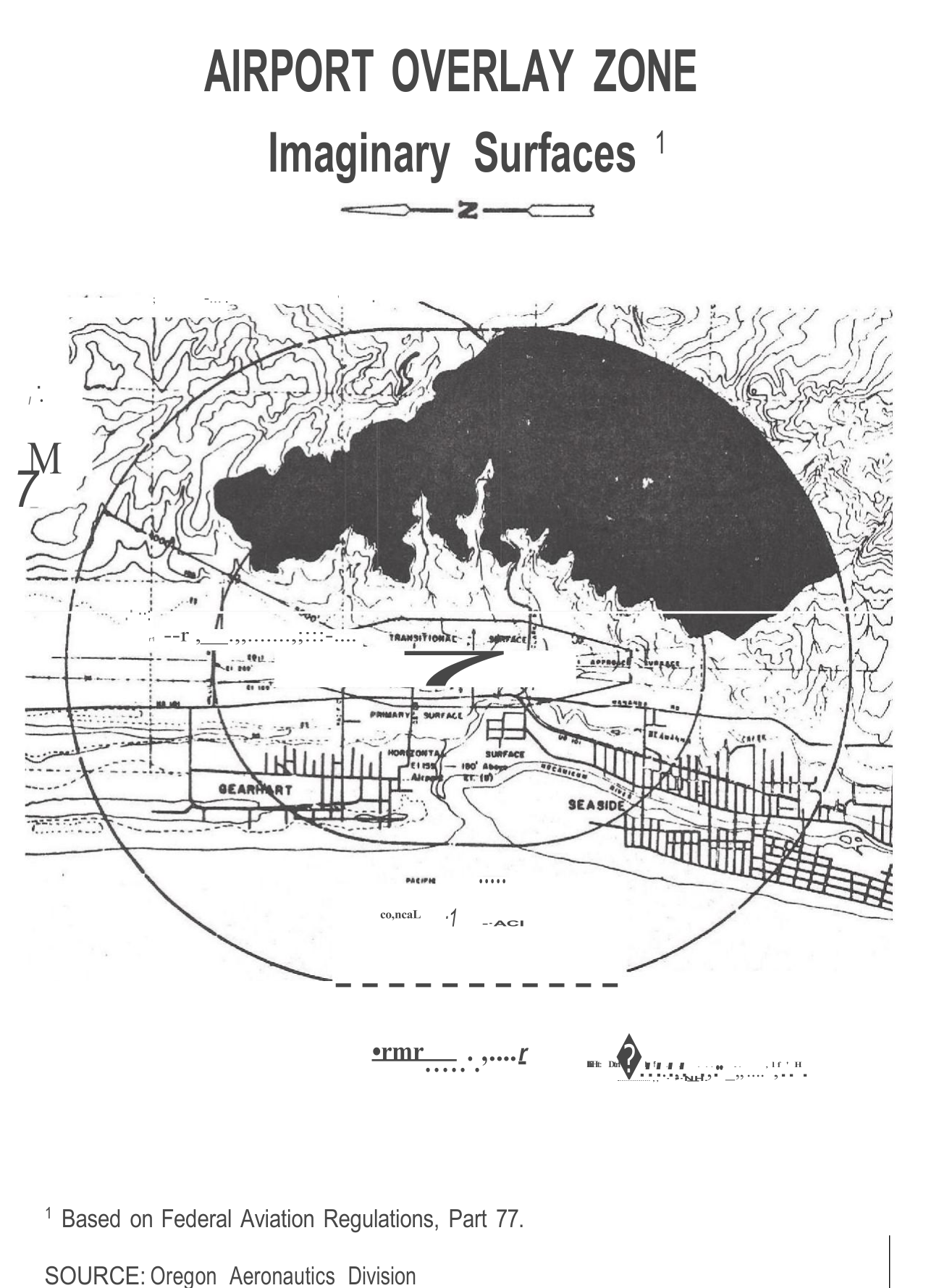
Article 4Transportation Improvements and Access Management
§ 4.010Access Requirements
§ 4.020Additional Criteria for Access Controls on Highway 101
For property fronting Highway 101 the following additional criteria applies.
Access management standards for US 101 shall be those standards required by ODOT.
Where a new approach onto US 101 or change of use adjacent to US 101 requires ODOT approval, the applicant is responsible for obtaining ODOT approval. The City Manager or designee may approve a development conditionally, requiring the applicant first obtain required ODOT permit(s) before commencing development, in which case the City will work cooperatively with the applicant and ODOT to avoid unnecessary delays.
§ 4.030Maintenance of Access
Right-of-way may be sold, exchanged or transferred.
Rights-of-way may be vacated to permit redevelopment of shoreland areas provided public access across the affected site is retained.
§ 4.040Transportation Improvements
General Requirements.
Purpose. The standards this chapter implement the transportation policies of the City of Gearhart Transportation System Plan.
Applicability. The following types of development are required to construct transportation improvements in accordance with the standards and procedures of this chapter.
New single-family dwelling or duplex, if the development fronts a street segment that is planned for a sidewalk or trail in the Transportation System Plan.
New multi-family dwelling.
New commercial development.
Major expansion of a commercial development defined by an increase in the gross floor area of the use by at least 25 percent.
All developments in the Residential Commercial Planned Development (RCPD) zone and subdivisions or partitions are required to construct improvements in accordance with the Gearhart Subdivision Ordinance.
Street, Shared-use Path, and Evacuation Route Design Standards. All transportation improvements, whether required as a condition of development or provided voluntarily, shall conform to the standards adopted within the City of Gearhart Transportation System Plan.
Public Improvement Requirement. No building permit may be issued until all required street improvements are in place and approved by the City Manager or designee, or otherwise bonded, in conformance with the provisions of this Code. Improvements required as a condition of development approval, when not voluntarily provided by the applicant, shall be roughly proportional to the impact of the development on public facilities. Findings in the development approval shall indicate how the required improvements directly relate to and are roughly proportional to the impact of development.
Improvements to Existing Streets.
Applicability. Except as provided by subsection 4, below, existing substandard streets within or abutting a proposed development shall be improved in accordance with the standards of this chapter as a condition of development approval. The City Manager or designee may waive or modify this requirement where the applicant demonstrates that the condition of existing streets to serve the development meet city standards and are in satisfactory condition to handle projected traffic loads.
Single-Family Dwellings and Duplexes. All single-family dwellings and duplexes that front an existing street segment that is planned for a sidewalk or trail in the Transportation System Plan shall construct sidewalk or trail improvements in accordance with the standards of that plan. The improvements may include but are not limited to sidewalks, trails, curbs, gutters, and planter strips.
Multi-Family Dwellings and Commercial Development. All multi-family dwelling and commercial development shall construct a minimum of half-street improvements to all existing streets adjacent to, within, or necessary to serve the development in accordance with the standards of the Gearhart Transportation System Plan. Where a development has frontage on both sides of an existing street, full street improvements shall be required.
Waivers and Deferrals. The City Manager or designee may waive or allow deferral of standard street improvements, including sidewalk, roadway, bicycle lane, undergrounding of utilities, and landscaping, as applicable, where one or more of the following conditions in (A) through (D) is met. Deferrals of sidewalk improvements are not permitted when there is an existing curb along the frontage of the site, or the site is abutting an existing curb or sidewalk. Where the City Manager or designee agrees to defer a street improvement, it shall do so only where the property owner agrees not to remonstrate against the formation of a local improvement district in the future.
The standard improvements conflict with an adopted capital improvement plan.
The standard improvements would create a safety hazard.
The improvement is not likely to be extended during the planning horizon of the adopted TSP due to topography or committed development on adjacent property, and the improvement under consideration does not by itself significantly improve transportation operations or safety.
The improvements are deemed more appropriate as part of a larger project in the future.
Fee-in-Lieu Option. In lieu of the transportation improvement requirements identified in Section 4.040, the City Manager or designee may elect to accept from the applicant monies to be placed in a fund dedicated to the future public construction of the improvements.
The amount of monies deposited with the city shall be at least 100 percent of the estimated cost of the required street improvements and may include more than 100 percent of the cost as required for inflation. Cost estimates shall be based from a preliminary design of the reconstructed street provided by the applicant’s engineer and shall be approved by the city engineer or designee.
If the City Manager or designee elects to accept these monies in lieu of the street improvements, the applicant shall also record against all lots or parcels a “construction deferral agreement and waiver of rights to remonstrance for street and storm drainage improvements” approved by the city attorney. The agreement should be worded such that the subject properties are responsible for paying the full cost of required street improvements along their unimproved street frontages. The agreement shall also state that the city has the right to collect money owed for the actual construction costs, if actual costs exceed the amount deposited, and that the city will reimburse the property owner(s) if the actual costs are less than anticipated.
§ 4.050Transportation Improvements Permitted Outright
Except where otherwise specifically regulated by this ordinance, the following improvements are permitted outright:
Normal operation, maintenance, repair, and preservation activities of existing transportation facilities.
Installation of culverts, pathways, medians, fencing, guardrails, lighting, and similar types of improvements within the existing right-of-way. Fencing must meet the requirements of Section 6.010.
Projects that are consistent with projects identified and planned for in the Transportation System Plan.
Landscaping as part of a transportation facility.
Emergency measure necessary for the safety and protection of property.
Acquisition of right-of-way for public roads, highways, and other transportation improvements designated in the Transportation System Plan.
Construction of a street or road as part of an approved subdivision or land partition consistent with the Gearhart Subdivision ordinance.
§ 4.060Access Managements Standards
Purpose. The purpose of this ordinance is to manage access to land development while preserving the movement of people and goods in terms of safety, capacity, functional classification, and performance standards as adopted in the Transportation System Plan. This ordinance shall apply to all arterials and collectors within the City of Gearhart and to all properties that abut these roadways at which time new or redevelopment occurs.
Nonconforming Access Features. Legal access connection in place as of August 2, 2017 that do not conform with the standards herein are considered nonconforming features and shall be brought into compliance with applicable standards under the following conditions:
Changing in use or enlargements or improvements that will increase trip generation.
Exceptions and Adjustments. The City Manager or designee may approve adjustments to the spacing standards of subsection 4, above, where an existing connection to a City street does not meet the standards of the roadway authority and the proposed development moves in the direction of code compliance. The City Manager or designee may also approve a deviation to the spacing standards on City streets where it finds that mitigation measures, such as consolidated access (removal of one access), joint use driveways (more than one property uses same access), directional limitations (e.g., one-way), turning restrictions (e.g., right-in/right-out only), or other mitigation alleviate all traffic operations and safety concerns.
Long-term Consolidation of Access. The number of driveway and private street intersections with public streets shall be minimized by the use of shared driveways with adjoining lots where feasible. The City shall require shared driveways as a condition of land division or site development review, as applicable, for the traffic safety and access management purposes in accordance with the following standards:
Shared driveways and frontage streets may be required to consolidate access onto a collector or arterial street. When shared driveways or frontage streets are required, they shall be stubbed to adjacent developable parcels to indicate future extension. “Stub” means that a driveway or street temporarily ends at the property line but may be extended in the future as the adjacent parcel develops. “Developable” means that a parcel is either vacant or it is likely to receive additional development (i.e., due to infill or redevelopment potential).
Reciprocal access easements (i.e., for the benefit of affected properties) shall be recorded for all shared driveways, including paths, at the time of final plat approval or as a condition of the site development approval.
Access Consolidation Exception. Shared driveways are not required when existing development patterns or physical constraints (e.g., topography, parcel configuration, and similar conditions) prevent extending the street/driveway in the future.
§ 4.070Traffic Impact Analysis
Purpose. The purpose of this section is coordinate the review of land use applications with roadway authorities and to implement Section 660-012-0045(2)(e) of the state Transportation Planning Rule, which requires the City to adopt a process to apply conditions to development proposals in order to minimize impacts and protect transportation facilities. The following provisions also establish when a proposal must be reviewed for potential traffic impacts; when a Traffic Impact Analysis must be submitted with a development application in order to determine whether conditions are needed to minimize impacts to and protect transportation facilities; the required contents of a Traffic Impact Analysis; and who is qualified to prepare the analysis.
When a Traffic Impact Analysis is Required. The City or other road authority with jurisdiction may require a Traffic Impact Analysis (TIA) as part of an application for development, a change in use, or a change in access. A TIA shall be required where a change of use or a development would involve one or more of the following:
Changes in land use designation, or zoning designation that will generate more vehicle trip ends.
Projected increase in trip generation of 25 or more trips during either the AM or PM peak hour, or more than 300 daily trips.
Potential impacts to intersection operations.
Potential impacts to residential areas or local roadways, including any non-residential development that will generate traffic through a residential zone.
Potential impacts to pedestrian and bicycle routes, including, but not limited to school routes and multimodal roadway improvements identified in the TSP.
The location of an existing or proposed access driveway does not meet minimum spacing or sight distance requirements, or is located where vehicles entering or leaving the property are restricted, or such vehicles are likely to queue or hesitate at an approach or access connection, thereby creating a safety hazard.
A change in internal traffic patterns may cause safety concerns.
A TIA is required by ODOT pursuant with OAR 734-051.
Preparation. A professional engineer registered by the State of Oregon, in accordance with the requirements of the road authority, shall prepare the Traffic Impact Analysis.
Preapplication Conference. For proposals that meet one or more of the thresholds in section 2, above, the applicant shall attend a preapplication meeting in order to coordinate with the city staff, and ODOT as necessary, to discuss the scope of a required TIA prior to submitting an application. ODOT will be invited to participate in the preapplication conference when an approach road to Highway 101 serves the subject property to ensure the completed TIA meets the requirements of both agencies.
Approval Criteria.
The study complies with the content requirements set forth by the city engineer or designee and ODOT staff as appropriate.
The study demonstrates that adequate transportation facilities exist to serve the proposed land use action or identifies mitigation measures that resolve identified traffic safety problems in a manner that is satisfactory to the city engineer or designee and, if State facilities are affected, to ODOT.
§ 4.080Pedestrian Access and Circulation and Bike Parking
Purpose and Intent. This section implements the pedestrian access and connectivity policies of City of Gearhart Transportation System Plan and the Gearhart Parks and Recreation Master Plan policies for pedestrian and bicycle trails and routes. It is intended to provide for safe, reasonably direct, and convenient pedestrian access and circulation.
Standards. Developments shall conform to all of the following standards for pedestrian access and circulation:
Continuous Walkway System. A pedestrian walkway system shall extend throughout the development site and connect to adjacent sidewalks, if any, and to all future phases of the development, as applicable.
Safe, Direct, and Convenient. Walkways within developments shall provide safe, reasonably direct, and convenient connections between primary building entrances and all adjacent parking areas, recreational areas, playgrounds, and public rights-of-way conforming to the following standards:
The walkway is designed primarily for pedestrian safety and convenience, meaning it is reasonably free from hazards and provides a reasonably smooth and consistent surface and direct route of travel between destinations. The City Manager or designee may require landscape buffering between walkways and adjacent parking lots or driveways to mitigate safety concerns.
Improvements to existing and planned pedestrian and bicycle paths and connections shall be consistent with Gearhart Parks and Recreation System Master Plan policies and planned improvements.
Evacuation Routes. Evacuation routes identified in the Transportation System Plan must be constructed to the standards identified in the Transportation System Plan.
Vehicle/Walkway Separation. Except as required for crosswalks, per subsection 4, below, where a walkway abuts a driveway or street it shall be raised six inches and curbed along the edge of the driveway or street. Alternatively, the City Manager or designee may approve a walkway abutting a driveway at the same grade as the driveway if the walkway is physically separated from all vehicle-maneuvering areas. An example of such separation is a row of bollards (designed for use in parking areas) with adequate minimum spacing between them to prevent vehicles from entering the walkway.
Crosswalks. Where a walkway crosses a parking area or driveway (“crosswalk”), it shall be clearly marked with contrasting paving materials (e.g., pavers, light-color concrete inlay between asphalt, or similar contrasting material) or painted crosswalk striping. The crosswalk may be part of a speed table to improve driver-visibility of pedestrians.
Walkway Width and Surface. Unless exempted under 6.340(6), walkways shall be constructed of concrete, asphalt, brick or masonry pavers, or other durable surface, as approved by the City Manager or designee, and not less than five feet wide. Multi-use paths (i.e., designed for shared use by bicyclists and pedestrians) shall be concrete or asphalt and shall conform to city transportation standards.
Construction Exceptions. The Ridgeline Path and any beach paths may be constructed of soft-surface materials, as deemed appropriate by the City Manager or designee.
Article 5(For Future Use)
§ 5(For Future Use)
Article 6Supplementary Provisions
§ 6.010Accessory Uses
Accessory uses shall comply with all requirements for the principal use except where specifically modified by this ordinance and shall comply with the following limitations:
Fences
Fences which may be located within yards shall not exceed 6 feet in height.
Fences which may be located within “clear-vision” areas shall not exceed 2-1/2 feet in height and are subject to the provisions of Section 6.030 Clear-Vision Area.
The height of a fence shall be measured from the ground level where located.
Fences shall not consist of barbed wire or other sharp or otherwise dangerous construction material.
Fences abutting Highway 101 are subject to the ten-foot setback from the property line in accordance with Section 6.070 4(G).
All existing fences that do not comply with the fence provisions herein are considered nonconforming and subject to Section 10 of the Gearhart Zoning Code.
Maintenance of a Greenhouse or Solar Panel:
May be maintained adjacent to a dwelling providing the activity does not exceed that which requires a license under Chapter 571 of the Oregon Revised Statutes: Nurseries and Nurserymen.
Creating Obstructed Streets Prohibited. Creating an obstructed street, by the use of gates or other barriers is prohibited.
Recreation Vehicles. An occupant(s) of a residence within the City limits may park or store outside, but not live in, up to two (2) Recreational Vehicles (RV) on the residential premise. Additional RV’s may be parked on a temporary basis for a period not to exceed seven (7) days per calendar month.
Gearhart Property owners shall obtain a permit from the city, which allows, occupancy of an RV, up to two times a year, for up to ninety-six (96) hours, per time. The RV cannot be in the public right of way, and the permit may be revoked by the police chief or the chief’s designee, in their sole discretion.
Storage in Front Yard
Vehicles which are partially dismantled or do not have a valid State license shall not be stored more than 10 days in a required front yard or street side yard.
Outdoor Lighting
Lighting fixtures shall be shielded or recessed into the building design to avoid casting glare onto adjacent property or upward into the night sky.
A small wind energy system may be allowed as a Conditional Use in all zones in which structures are permitted and in accordance with the provisions of GZO Article 8 Conditional Uses.
Permit Submittal Requirements
Provide a written description and photographs of the WECS including manufacturer’s product materials and system certifications according to local and state building codes.
Provide a property site plan illustrating where the system will be located and how it conforms to the zone standards and the standards of this section.
Provide an illustration of the visual impacts of the system that may affect property owners in the area.
If applicable, provide evidence of local utility notifications of the proposed system and its location.
General Standards
The minimum distance between the ground, structure or tree and any part of a rotor blade must be at least 30 feet.
Small wind energy systems may not be illuminated, nor may they bear any signs or advertising.
Small wind energy systems must have automatic braking, governing, or feathering system to prevent uncontrolled rotation, over speeding, and excessive pressure on the support structure, rotor blades, and turbine components.
All wiring serving small wind energy systems must be enclosed or underground.
Noise produced by small wind energy systems may not exceed legal limits established by the City of Gearhart noise standards. Except when there is ambient noise, such as that caused by storms, then the noise level may be 10 decibels greater than ambient noise level.
Small wind energy systems must not cause any interference with normal radio and television reception in the surrounding area, with any public safety agency or organization (including but not limited to police, fire, ambulance, and Coast Guard) radio transmissions, or with any microwave communications link. The owner shall bear the costs of immediately eliminating any such interference should any occur or must immediately shut down the system or parts of the system causing the interference.
A finish (paint/surface) must be provided for the small wind energy system that reduces the visibility of the facility, including rotors. This condition may be satisfied by painting the support structure and rotors with flat light haze gray paint. If the support structure is unpainted it must be of a single color throughout its height. The owner must maintain the finish, painted or unpainted, so that no discoloration is allowed to occur.
The diameter of the area swept by the rotors may not exceed 25 feet.
Dilapidated structures or nonconforming systems shall be repaired to safe and functionality or removed from the site within six (6) months.
Freestanding Systems – Additional Standards
Small Wind energy systems may be mounted on a freestanding tower detached from other structures on the lot and are subject to the following standards:
Setback
The minimum setback from any property line, structure, tree or overhead utility line, or public right-of-way shall be a distance equal to the vertical distance from the ground to the tip of a wind generator blade when the tip is at its highest point unless the affected utility, property owner, or governmental entity grants written permission for a lesser setback. In addition to the system’s structures, guy wires associated with towers shall meet applicable setbacks for the zone district.
Height
Support structures for freestanding systems may not exceed 80 feet in height.
Security
Support structures for freestanding systems must be unclimbable from the ground to a height of at least 15 feet
Number
A maximum of one freestanding small wind generator system may be allowed on 10,000 square feet or less. One additional freestanding system is allowed for each 10,000 square feet of lot area.
Roof-Mounted Systems – Additional Standards
Small wind energy systems must meet required minimum setbacks of the zone and may be mounted on the roof of a structure as an appurtenance.
Height. Roof-mounted systems may not be more than five feet over the maximum allowed height for the structure measured from the highest tip of the wind generator blade. A certified structural analysis of the roof or wall supporting the system shall be provided.
Number. There is no maximum number of roof-mounted systems permitted.
Engineering Report. Before any roof-mounted system is mounted the property owner must submit a report prepared by an Oregon licensed professional engineer attesting to the fact that the structure to which the system will be mounted is or will be sufficiently strong to support the system and to withstand the wind, vibratory, and other loads to which it would be subjected as a result of mounting the system on it. This report is subject to approval by the City Building Official prior to the installation of the system.
§ 6.020Sign Requirements
Purpose. The purpose of this section is to regulate such factors as the size, location, and illumination of signs with the intent of safeguarding and enhancing the City’s visual environment, traffic safety and the City’s economic well being.
General Requirements
The following general requirements shall apply to all signs:
Signs shall not contain flashing elements or moving, rotating or other such animated parts.
All signs and sign structures shall be erected and attached totally within the site, except where permitted to extend into a street right-of-way.
Signs shall not extend into or over or upon any public street or right-or-way. Except a sign may extend over a public sidewalk provided the bottom of the sign structure shall be at least eight (8) feet above the grade of the sidewalk and the sign does not project more than three (3) feet into the public right-of-way.
Signs or sign support structures shall not be located so as to detract from a motorist’s view of vehicular or pedestrian traffic, or a traffic sign.
Only one side of a double-faced sign is counted in measuring the area of a sign. Sign area does not include foundation supports and other essential structures which do not serve as a backdrop or border of the sign.
All signs shall be kept in good repair and maintenance.
Permanent signs are not permitted on undeveloped site i.e. a lot without a use.
Additional Residential Zone Sign Requirements (RA, R-1, R-2, R-3 Zones)
Sign Requirements: Rural Agricultural, (R-A), Low Density Residential, (R-1), Medium Density Residential, (R-2),
Uses permitted outright shall have permanent signs with an area not exceeding one square foot and be attached to a building.
Conditional uses shall have permanent signs with an area not exceeding twelve (12) square feet.
Temporary signs with an area not exceeding six (6) square feet may be permitted.
Sign Requirements: R-3 High Density Residential
Permitted and conditional uses shall have permanent signs with an area not exceeding twenty-four (24) square feet.
Temporary signs with an area not exceeding six (6) square feet may be permitted.
Sign Requirements: (C-1, C-2, C-3, & RCPD): Commercial Zone Additional Sign Requirements
Sign Requirements: (C-1), Neighborhood Commercial Zone
Permitted and conditional uses shall have permanent signs with an area limited to two (2) feet in height by the street frontage of said building, flush with the building.
Temporary signs with an area not exceeding eight (8) square feet may be permitted.
Sign Requirements: (C-2, C-3, RCPD); General Commercial, (C-2), Higher Intensity Commercial, (C-3), and Residential Commercial Planned Development Zones (RCPD). Sign Requirements.
Permitted and conditional uses shall have permanent signs limited to one free standing sign per business or in the case of business complexes or malls one free standing sign per business complex or mall, not to exceed 32 square feet, and/or one sign, flush to the building, limited to 2 feet high by 12 feet long.
Temporary signs with an area not exceeding twelve (12) square feet may be permitted.
Sign Requirements: (P/SP, P): Public and Park Zone Additional Sign Requirements
Permitted and conditional uses shall have permitted signs with an area not exceeding twelve (12) square feet.
Temporary signs with an area not exceeding eight (8) square feet may be permitted.
Sign Requirements: (A-2, FW): Aquatic and Freshwater Wetland Zone Additional Sign Requirements.
No signs shall be permitted in this zone.
A Sign Permit shall be required prior to construction or placement of any sign on forms provided by the City. Fees for sign construction or placement shall be in accordance with Sec. 13.080.
§ 6.025Temporary Election Related Signs Exempt from Permit and Fee
The following signs shall comply with all provisions and regulations of this chapter; however, no fee, permit, or application is required. Temporary signs are prohibited signs except as provided by this section.
Generally.
Illumination: No temporary sign shall be internally or externally illuminated.
Location:
Except as provided by this section, no temporary sign shall extend into or over the public right-of-way of any street.
No temporary sign shall extend into the vision clearance area.
Maintenance: Temporary signs shall be kept neat, clean and in good repair. Signs which are faded, tom, damaged or otherwise unsightly or in a state of disrepair shall be immediately repaired or removed.
Placement: Except as provided by this section, temporary signs shall not be attached to trees, shrubbery, utility poles, or traffic control signs or devices on public right of way. They shall not obstruct or obscure primary signs on adjacent premises.
Sign Collection and Retrieval:
The City may collect temporary signs placed in the public right of way without a permit.
Each sign collected will be stored for a minimum of 30 days.
Allowed Signage.
In any residential zone, temporary signage shall be allowed for each and every lot. This signage shall not be restricted by content, but is usually and customarily political or ideological positions. Signage shall be allowed for each lot as follows:
Temporary signs not exceeding six square feet, provided the signs are erected not more than 90 days prior to an election and removed within five days following the election.
Temporary signs erected within a building which do not obstruct more than 10 percent of any individual window surface.
Candidate signs shall meet state law requirements.
Only one sign allowable per candidate and/or measure.
§ 6.030Clear-Vision Areas
A clear-vision area shall be maintained on the corners of all property at the intersection of two streets or a street and a railroad.
A clear-vision area shall consist of a triangular area, two sides of which are lot lines measured from the corner intersection of the street lot lines for a distance specified in this regulation, or, where the lot lines have rounded corners, the lot lines extended in a straight line to a point of intersection and so measured, and the third side of each is a line across the corner of the lot joining the non-intersecting ends of the other two sides.
A clear-vision area shall contain no plantings, fence, wall, structure, or temporary or permanent obstruction exceeding 2-1/2 feet in height, measured from the top of the curb or, except that trees exceeding that height may be located in this area provided all branches and foliage are removed to a height of 8 feet above the grade.
The following measurements shall establish clear-vision areas:
In a residential zone the minimum distance shall be 15 feet or, at intersections including an alley, 10 feet.
§ 6.040Maintenance of Minimum Setback and Open Space
No lot area, yard, other open space, or off-street parking or loading area existing on or after the effective date of this ordinance shall be reduced below the minimum required for it by this ordinance.
Accessory Building Yard Reduction:
Regardless of the yard requirements of the zone, a rear yard may be reduced to 5 feet for an accessory structure erected more than 60 feet from a street other than an alley provided the structure is detached from other buildings by 5 feet or more and does not exceed a height of one story nor an area of 450 square feet.
Dual Use of Required Open Space:
No Lot area, yard, or other open space or off-street parking or loading area which is required by this ordinance for one use shall be a required lot area, yard, or other open space or off-street parking or loading area for another use.
§ 6.050Home Occupation
A home occupation when conducted as an accessory use to a dwelling in a residential zone shall be subject to the following limitations:
No person shall be employed other than a member of the family residing on the premises.
The residential character of the building shall be maintained, and the activity shall not have the outward appearance of business nor detract from the residential character of the neighborhood.
No exterior storage or display shall be permitted.
No home occupation shall be conducted in an accessory structure.
Exterior signs shall be limited to those permitted in the zone in which the home occupation is located. There shall be no other exterior indication of the home occupations.
A home occupation which creates a nuisance because of noise, smoke, dust, or gas is prohibited.
No traffic shall be generated by such home occupation in greater volumes than would normally be expected in a residential neighborhood, and any need for parking generated by the conduct of such home occupation shall be met off the street and other than in a required front yard.
A home occupation shall not include retail sales.
Complaints on conditions 1 through 5 of Section 6.050 will be handled routinely by the City Administrator. Complaints on conditions 6 through 8 will be dealt with as follows: The Planning Commission shall review home occupations upon receipt of written complaints, or a complaint from the City Administrator. Said complaints shall set forth the nature of the objection. Such complaints shall be investigated by the City Administrator, and results of the investigation shall be reported to the Commission at a public hearing. The public hearing procedure shall be the same as outlined in Section 13.050.
§ 6.060Off-Street Parking and Loading Requirements
OFF-STREET PARKING
No off-street parking is required in a C-1Zone, except residential dwellings and neighborhood cafes located in a new structure within a C-1 Zone are required to have off-street parking. Residential dwellings and neighborhood cafes in an existing structure within the C-1 zone are not required to have off-street parking:
In all other zones,
At the time a structure is erected or enlarged, or the use of a structure or parcel of land is changed within any zone in the City, off-street parking spaces shall be provided in accordance with the requirements of this section and zone designation standards listed in Article 3 unless greater requirements are otherwise established.
If parking space has been provided in connection with an existing use, the parking space shall not be eliminated if it would result in less than is required by this section.
Where square feet are specified the area measured shall be the gross floor area primary to the functioning of the particular use of property but shall exclude space devoted to off-street parking or loading.
Where employees are specified, persons counted shall be those working on the premises, including proprietors, during the largest shift at peak season.
Fractional space requirement shall be counted as a whole space.
Parking spaces shall be a minimum of nine (9) feet by eighteen (18) feet for standard spaces, and eight (8) feet by sixteen (16) feet for compact spaces.
For uses requiring four or more spaces, up to fifty percent (50%) of the spaces may be compact in size.
Bicycle Parking
Standards. Bicycle parking spaces shall be provided with new development and, where a change of use occurs, at a minimum, shall follow the standards in Table 6.060(1). Where an application is subject to Conditional Use Permit approval or the applicant has requested a reduction to an automobile-parking standard, the City Manager or designee may require bicycle parking spaces in addition to those in Table 6.060(1).
Design. Bicycle parking shall consist of staple-design steel racks or other City-approved racks, lockers, or storage bins, providing a safe and secure means of storing a bicycle.
Exemptions. This section does not apply to single-family and duplex housing, home occupations, and agricultural uses. The City Manager or designee may exempt other uses upon finding that, due to the nature of the use or its location, it is unlikely to have any patrons or employees arriving by bicycle.
Hazards. Bicycle parking shall not impede or create a hazard to pedestrians or vehicles and shall be located so as to not conflict with the vision clearance standards of this code.
| Table 6.060(1) Minimum Required Bicycle Parking Spaces | |
|---|---|
| Use | Minimum Number of Spaces |
| Multifamily Residential (not required for parcels with fewer than 4 dwelling units) | 2 bike spaces per 4 dwelling units |
| Commercial | 2 bike spaces per primary use or 1 per 5 vehicle spaces, whichever is greater |
| Community Service | 2 bike spaces |
| Parks (active recreation areas only) | 4 bike spaces |
| Schools (all types) | 2 bike spaces per classroom |
| Institutional Uses and Places of Worship | 2 bike spaces per primary use or 1 per 10 vehicle spaces, whichever is greater |
| Other Uses | 2 bike spaces per primary use or 1 per 10 vehicle spaces, whichever is greater |
PARKING SPACES REQUIRED FOR EACH USE:
Residential:
Dwelling. Two spaces per dwelling unit
Motel, tourist court, rooming or boarding house. One and one-half spaces per guest accommodation plus one additional space for the owner or manager.
Trailer or mobile home parks. One and one-half spaces per trailer or mobile home.
Convalescent, nursing and other health homes and institutions, homes for the aged, children’s homes and welfare or correctional institutions. One space per 3 beds for patients.
Public and Semi-Public Buildings and Uses:
Auditorium, church, or meeting room (other than a school) One space for each 60 square feet of floor area in the auditorium or, where seating is fixed to the floor, one space per 4 seats or 8 feet of bench length.
Club, lodge or association. Spaces to meet the combined requirements of the uses being conducted such as hotel, restaurant, auditorium, etc.
Library. One space per 400 square feet of reading room plus one space per employee.
Kindergarten, pre-school nursery, equivalent private or parochial schools. Two spaces per teacher.
Elementary, junior high or equivalent private or parochial school. One and one-half spaces per classroom, plus 1-1/2 spaces per administrative employee plus one space per 60 square feet or 4 seats or 8 feet of bench length in the auditorium or assembly room.
Post office. One space for each 1,000 square feet of floor area.
Commercial
Retail store, except as provided in subsection (h) below. One space for each 200 square feet of gross floor area.
Service or repair shop or retail store handling bulky merchandise such as automobiles or furniture. One space for each 600 square feet of gross floor area.
Bank or office except medical or dental. One space for each 400 square feet plus one space pre-employee.
Medical or dental office or clinic. One space per 300 square feet of floor area.
Eating or drinking establishment. One space per 200 square feet of floor area.
Mortuary. One space per 2 chapel seats or 4 feet of bench length.
Storage or wholesale use. One space per 700 square feet of patron serving area.
Commercial Recreation
Bowling alley. Four spaces for each alley.
Dance hall, skating rink, or gymnasium. One space per 50 square feet of patron area.
Outdoor arena or theater. One space per 50 square feet of patron area.
Golf course. Two spaces per hole.
Swimming pool. One space per 100 square feet of pool.
Tennis court. Two spaces per court.
OFF-STREET LOADING REQUIREMENTS
At the time a structure is erected or enlarged, or the use of a structure or parcel of land changed within any zone in the City, off-street loading spaces shall be provided in accordance with the requirements of this section and Section 3 below unless greater requirements are otherwise established.
Merchandise, materials, or supplies:
Buildings or structures to be built or substantially altered which receive and distribute material or merchandise by truck shall provide and maintain off-street loading berths in sufficient numbers and size to adequately handle the needs of the particular use.
If loading space has been provided in connection with an existing use or is added to an existing use, the loading space shall not be eliminated if elimination would result in less space than is required to adequately handle the needs of the particular use.
Off-street parking areas used to fulfill the requirements of this ordinance shall not be used for loading and unloading operation except during periods of the day when not required to take care of parking needs.
Passenger loading zone: A driveway designed for continuous forward flow of passenger vehicles for the purpose of loading and unloading passengers shall be located on the site of any school or other public meeting place which is designed to accommodate more than 25 persons at one time.
OFF-STREET PARKING AND LOADING, GENERAL PROVISIONS
The following general provisions shall govern the application of off-street parking and loading requirements.
The provision and maintenance of off-street parking and loading spaces is a continuing obligation of the property owner. No building permit shall be issued until plans are presented that show property that is and will remain available for exclusive use as off-street parking and loading space. The subsequent use of property for which the building permit is issued shall be conditional upon the unqualified continuance and availability of the amount of parking and loading space required by this ordinance. Should the owner or occupant of a lot or building change the use to which the lot or buildings is put, thereby increasing off-street parking or loading requirements, it shall be a violation of this ordinance to begin or maintain such altered use until the required increase in off-street parking or loading is provided.
Owner of two or more uses, structures, or parcels of land may agree to utilize jointly the same parking and loading spaces when the hours of operation do not overlap, provided that satisfactory legal evidence is presented to the City in the form of deeds, leases, or contracts to establish the joint use.
Off-street parking spaces for one or two-family dwellings shall be located on the same lot with the dwelling. Other required parking spaces shall be located not farther than 200 feet from the building or use they are required to serve, measured in a straight line from the building.
Required parking spaces shall be available for the parking of passenger automobiles of residents, customers, patrons, and employees only, and shall not be used for storage of vehicles or materials or for the parking of trucks used in conducting the business or use.
A Plan drawn to scale, indicating how the off-street parking and loading requirements are to be met shall accompany an application for a building permit.
Design requirements for parking lots and loading areas shall be as follows:
Except for parking to serve residential uses, parking and loading areas adjacent to or within residential zones or adjacent to residential uses shall be designed to minimize disturbance of residents by the erection between the uses of a sight obscuring fence, screen or hedge of not less than 5 or more than 6 feet in height except where vision clearance is required.
Artificial lighting which may be provided shall not create or reflect substantial glare in a residential zone or on any adjacent resident dwelling located in a non-residential zone.
On parking lots having 4 or more parking spaces, such spaces shall be clearly marked in a permanent manner.
Service drives to off-street parking area shall be designed and constructed to facilitate the flow of traffic, provide maximum safety of pedestrians and vehicular traffic on the site. The number of service drives shall be limited to the minimum that will allow the property to accommodate and service the traffic to be anticipated. Service drives shall be clearly and permanently marked and defined through use of rails, fences, walls, or other barriers or markers on frontage not occupied by service drives.
Service drives shall have a minimum vision clearance area formed by the intersection of the driveway center line, the street right-of-way line, and a straight line joining said lines through points 20 feet from their intersection.
§ 6.070Landscaping, Vegetation & Revegetation and Tree Preservation
All new sub-divisions shall provide landscaping to buffer the sub-division from Highway 101. A landscape plan and time schedule for the implementation of the plan will be submitted as a part of the development application to the Planning commission for approval.
A landscaping plan shall be submitted to the City Administrator for approval before building permits are issued for any new development on lots adjacent to Highway 101.
As a minimum requirement, a 10-foot wide strip of landscaping adjoining the Highway right-of-way shall be provided.
Landscaping requirements adjacent to US Highway 101:
As a minimum requirement, a 10-foot wide strip of landscaping shall be provided adjoining the Highway right-of-way.
A landscaping plan shall be submitted to the City Administrator for approval before building permits are issued for any new development on lots adjacent to Highway 101. The landscaping plan shall include a maintenance schedule with a provision for routine placement of plants that fail to survive. Landscaping plans shall comply with the standards of Section 6.030 Clear Vision Area.
All new subdivisions shall provide a landscaping area to buffer the subdivision from Highway 101. A landscape plan and time schedule for the implementation of the plan shall be submitted to the City as part of the development application to the Planning Commission.
Required landscaping areas shall preferably consist of native plant species which are compatible with the weather of the coastal environment and the soils types of the site. Examples of native plants are described by the book “Plants of the Pacific Northwest Coast by Pojar and MacKinnon” and on the list from “The Western Gardener” available at City Hall. In addition to native plants, edible plants, fruits, vegetables, and nuts shall also be permitted.
With Planning Commission review, applicants may request that non-native plants be placed on the list of acceptable plants within required landscaping areas.
No plants prohibited by the City of Gearhart shall be permitted.
All structures, including any fence, shall be setback ten feet from the property line adjacent to US Highway 101.
RIPARIAN VEGETATION
Riparian vegetation adjacent to streams and lakes in Gearhart shall be protected in accordance with the following provisions:
The following area of riparian vegetation are defined:
Fifty feet on either side of Neacoxie Creek.
Fifty feet on either side of Mill Creek.
Twenty-five feet adjacent to the unnamed lake north of east Pacific Way. The setback shall be measured from the mean high-water line on estuarine portions and the ordinary high-water line for non-estuarine portions of these streams. Riparian vegetation within this setback shall be protected as specified in Section 6.070.
All structures and uses shall be located outside of areas listed in (A) above with the following exceptions:
Structural shoreline stabilization; or
For area described in (A) above all vegetation shall be retained within the areas listed with the following exceptions:
Removal of dead, diseased or dying trees, or trees that pose a safety hazard.
Removal of vegetation necessary to provide for uses listed in (B) above.
Vegetation removal in conjunction with an approved in-water project.
The removal of noxious weeds as defined by the City’s nuisance ordinance.
Vegetation removal necessary to maintain proper stream drainage.
REVEGETATION STANDARDS
The following standards shall apply to all areas from which vegetation is removed by either natural or man caused means. Except that in the Beaches and Dunes Overlay Zone vegetation removal and revegetation unrelated to the earth movement and earth removal standards of this section are provided in B.A.D. Zone Section 3.1240 2. D.
Areas from which vegetation is removed shall be replanted in accordance with the sections below within one growing season after the removal.
Areas on the Active or Conditionally Stable Dune from which beach grass is removed shall be replanted with beach grass or other native and typical vegetation for the area.
All other areas shall be planted with a plant material that will achieve 70% ground coverage within three years of planting.
VIOLATIONS
Violations of this section, including non-conformance with the provisions of a revegetation permit, shall be penalized as provided in Section 15.
PRESERVATION AND REMOVAL OF TREES
Purpose:
The purpose of this section is to recognize that trees are a significant aesthetic and environmental resource within the City of Gearhart and to create conditions favorable to the preservation of this plant heritage for the benefit of the current and future residents of the City. The purpose is not to prohibit the removal of all trees, but to ensure that mature trees are removed only where necessary, and to permit the reasonable development and use of property.
Definitions:
Tree: For the purpose of this section, “tree” is defined as follows: Any tree with a primary trunk greater than thirty-eight (38) inches in circumference as measured four and one half (4-1/2) feet above the existing grade.
Fifty-Five Inch Tree: Any tree with a primary trunk greater than fifty-five (55) inches in circumference as measured four and one half (4-1/2) feet above the existing grade.
Heritage Tree: A tree identified by the City Council as a Heritage Tree.
Heritage Tree and 55 Inch Tree Root Zone: The root zone is equal to the diameter of the trunk at 4.5 feet above the ground times 12 inches in any direction from the trunk. For example, a Heritage Tree with 55 inch circumference and 17.5 inch diameter has a root zone extending 210 inches (17.5 feet) in all directions from the trunk.
Applicability:
This section does not apply to the removal of trees listed on the State of Oregon Department of Agriculture noxious weeds list, and does not apply to the removal of English Holly, Cherry Laurel, and Siberian Elm.
Requirements:
One or more minor tree removal permits may be granted for
the removal of up to three total trees within any twelve month period; or
the removal of an unlimited number of trees, 55 inch trees and heritage trees in the following situations:
In order to construct proposed improvements, including the placement of structures and on-site sewerage disposal facilities, replacement sewerage disposal facilities, access ways, utilities, and essential grade changes authorized by a City Building Permit or County Septic Permit.
The tree(s) threaten the integrity of a septic system, or tree removal is needed to repair or maintain a septic system.
The tree height is within 20 feet of the maximum tree height limits of an applicable Airport Hazard Overlay Zone.
Removal of more than three trees within any twelve month period, or removal or impact to the root zone of one or more Heritage Trees or 55 Inch Trees may be permitted as a major tree removal permit. The Planning Commission may grant or deny a request for a major tree removal permit on the basis of the criteria set forth below in Section 6.070(8)(E), after conducting public notice and a hearing consistent with Article 13.
Such conditions as are deemed necessary and appropriate to ensure the proper enforcement of this section may be made part of the major removal permit. Such conditions may involve, but are not limited to the following:
The replacement of the trees proposed for removal with trees of a suitable type, size and location. Replacement trees must measure at minimum 5 feet tall for evergreen trees and 10 gallon size for deciduous trees.
A Plan for protecting trees on the project site during and after development.
Tree removal that is to be undertaken in conjunction with a specific development project shall occur only after a building permit has been issued, or the Planning Commission or City Council has approved an activity requiring the removal of the trees.
An approved tree removal permit shall be void after one year from its issuance unless a shorter period was specified as a condition for approval.
Major Tree Removal Permit Criteria: The granting of a major tree removal permit shall be based on a finding that at least one of the following criteria is met:
Necessity to remove trees which poses a safety hazard.
Necessity to remove trees which are diseased. Evidence of disease may be provided by a qualified tree care specialist who will not be involved in their removal.
Solar access; and the need to remove trees which deposit needles or other debris on rooftops. The burden of proof is on the applicant to show that other design alternatives which do not require the tree removal are not practical or will create a significant economic hardship.
Heritage Tree Designation:
Heritage trees shall be those trees designated by the City Council following review of a nomination form submitted by a citizen and accepted, in writing, by the property owner. If a proposed Heritage Tree is on private property, the property owner must give written consent to the Heritage Tree Application before such application can proceed.
The following criteria shall be used:
Minimum circumference at four and one half feet above ground = point value 5
Rapid growing (Douglas Fir, Giant Sequoia, etc.) – 138"
Moderate growing (Oregon White Oak, Scarlet Oak) – 107"
Slow and smaller growing (Ginkgo, Madrone) – 86"
Condition factor point values:
| 5 | Excellent – perfect form, little or no dead wood, all limbs have good attachments, no sign of decay |
| 4 | Very good – good form, multi-leaders, but with good attachments, 10% or less large dead wood |
| 2 | Good – unbalanced or incomplete crown, tight limb angles, 15% – 20% larger dead wood |
| 1 | Poor – evidence of some decay, 20% – 30% larger dead wood, history of being topped |
| 0 | Very poor – structurally unsound, extensive decay, dieback, poor form, unbalanced or greatly reduced crown. |
Historical factor is determined by the tree’s relative historic significance. Historic significance may be determined by the tree’s association with historic or famous events, the cultural history of the nation, State, community or person or persons who have significantly contributed to the history of the nation, state or community. Local historians may be called upon for research assistance for this category. Point values:
| 5 | Very significant |
| 4 | Significant |
| 3 | Somewhat significant |
| 2 | Marginally significant |
| 1 | Not significant |
Formula: size x location x condition x historical factor = heritage tree points
Trees shall accumulate a minimum off 180 points to receive consideration as a heritage tree.
Upon a tree being designated as a Heritage Tree, a plaque so designating may be placed upon or near said tree. A Heritage Tree may not be removed without a public hearing and approved major tree removal permit at least 30 days prior to the proposed date of removal.
Trees in Rights of Way.
Trees located within the public right-of-way are not routinely maintained by the City of Gearhart. Maintenance or removal may be initiated by either the property owner or the City, depending on the situation.
Appeals of a decision of the City Administrator or Planning Commission shall be in accordance with Section 13.060.
Enforcement. Enforcement of this section shall be in accordance with Article 15 of this ordinance, or by other ordinances the City Council may adopt to implement the purpose of this section.
§ 6.080Excavation Fill, Grading and Revegetation
It is the purpose of this section to provide the administrative means and guidelines to ensure the careful use of the fragile landform that Gearhart is situated on. Recognizing that the City rests on active dunes, conditionally stable dunes, and stable dunes, the excavation, fill and grading elements of this section are designed to assure that earth movement and removal is performed in a manner minimizing negative effects on the site and area, and the revegetation elements of this section are designed to protect the fragile soils and the community from erosion damage.
EXCAVATION, FILL AND GRADING STANDARDS
Chapter 70 of the Uniform Building Code (International Conference of Building Officials) is here by adopted by reference as applicable to all excavation and fill within the Gearhart City Limits and Urban Growth Boundary.
VIOLATIONS
Violations of this section, including non-conformance with the provisions of a revegetation permit, shall be penalized as provided in Section 15.
§ 6.090Protection of Archaeological Sites
The Building Official shall review building permits and the City Administrator shall review other proposed land use actions that may affect known archaeological site.
If it is determined that a proposed building permit or land use action may affect a known archaeological site, the City shall notify the State Historic Preservation Office. Such notification shall request assistance in determining whether the proposed action will in fact affect the identified archaeological site.
If the State Historic Preservation Office determines that a site would be affected it shall be requested to also develop appropriate measures to protect the site and its contents (appropriate measures are defined in Section 6.090(3).
No permit shall be issued unless one of the following has occurred:
The State Historic Preservation Office determines that the proposed action will not affect the archaeological site; or
The City has received no comment from the State Historic Preservation Office within twenty days of the date of written notification.
Indian cairns, graves and other significant archaeological resources, uncovered during construction or excavation shall be preserved until a plan for their excavation or re-internment has been developed by the State Historic Preservation Office. In development of the plan, the State Historic Preservation Office shall consider the appropriate measures listed in Section 6.090(3).
In development of a program to protect an archaeological site, the State Historic Preservation Office shall give consideration to the following appropriate measures:
Paving over the site without disturbance of any human remains or cultural objects.
Redesigning the proposed construction or excavation so as to avoid disturbing the site.
Setting the site aside for non-impacting portions of the proposed development such as storage.
If permitted pursuant to the substantive and procedural requirements of ORS 97.750, contracting with a qualified archaeologist to excavate the site and remove any cultural objects and human remains re-interring the human remains at the developer’s expense.
§ 6.100Standards for Manufactured Dwellings
The manufactured dwelling shall be multi-sectional and enclose a space of not less than 1,000 square feet.
The manufactured dwelling shall be placed on an excavated and backfilled foundation and enclosed at the perimeter such that the manufactured dwelling is located not more than 18 inches above grade and has conventional footings.
The manufactured dwelling shall have a pitched roof with a pitch of at least three feet in twelve.
The manufactured dwelling shall have exterior siding and roofing material commonly used on residential dwellings within the community or which is comparable to the predominant materials commonly used on surrounding dwellings as determined by the City Building Official.
The manufactured dwelling shall be certified by the manufacturer to have an exterior thermal envelope meeting performance standard which reduce levels equivalent to the performance standards required of single-family dwellings constructed under the state building code as defined in ORS 455.010.
The manufactured dwelling shall have a garage or carport constructed of like materials to the manufactured dwelling. Where surrounding dwellings have attached or detached garages, the City Building Official may require that the manufactured dwelling provide an attached or detached garage.
Article 7Vacation Rental Standards and Procedures
§ 7.010Purpose
The purpose of these provisions is to control, manage and limit vacation rentals primarily in single-family dwellings. Because of their location in residential zones, their specific characteristics and potential impacts, vacation rentals in dwellings in Gearhart require special consideration so they properly operate with respect to the Comprehensive Plan and the objectives of the underlying zone districts.
§ 7.020Special Standards Governing Vacation Rentals
Neighborhood Exemptions.
The Palisades, the Highlands and the East Pine Street neighborhoods are exempt from these provisions because they are not located in the Gearhart city limits
R-3 Zone.
A vacation rental in a multi-family dwelling that is zoned R-3 where the multi-family dwelling has 24-hour on-site management is exempt from these provisions. Multi-family dwellings (including condominiums) without 24-hour on-site management and single-family dwellings shall obtain a permit from the city in accordance with these provisions. In either case, vacation rentals are permitted and the number of permits in the R-3 zone is unlimited.
Limited Permit Offering to obtain a Vacation Rental Permit
Upon the effective date established by City Council Ordinance there will be a one-time 60-day period in which a property owner may file an application for a vacation rental permit from the City of Gearhart. At the time of application, the applicant shall provide proof that city lodging taxes were paid on the subject property prior to the end of the 60-day application period. When the one-time 60-day application period expires there shall be no new permit opportunities. The permit application must be deemed complete within 180 days of submittal.
During the permit offering a duplex or multi family structure in a R-2 zone is allowed one (1) vacation rental dwelling permit per dwelling unit.
Ownership Transfer of a Permit: A vacation rental permit is transferable only by inheritance. A natural person (owner or his/her representative) shall provide the name change to the city for verification and permit renewal. It is the intent that the sale of homes with a rental permit will result in gradual attrition of the total number of dwellings with a vacation rental permit in the city. See Section 8 below.
§ 7.030Vacation Rental Permit Standards and Procedures
Maximum Occupancy Calculation
Occupancy of the rental will be calculated using the three criteria below. Final occupancy will be set by the most limiting criterion. In accordance with the provisions of Article 9 Variances, an applicant may file an application for a Variance to the Maximum Occupancy Calculation standards.
Bedrooms/Occupancy – The maximum occupancy for a vacation rental dwelling shall be two persons over the age of 2 years old per bedroom. Occupancy includes occupants sleeping on the property.
Off-Street Parking – One outside parking space per bedroom is required. A standard parking space shall be a minimum of 9’ x 18’, except that a 9’ x 15’ space is permitted for existing structures where the structure is only 15’ from the property line. For uses requiring four or more spaces, up to fifty percent of the spaces may be compact in size. A compact space shall be a minimum of 8’ x 16’, or 15’ in depth where the structure is only 15’ from the property line. Residential parking spaces are not required to be marked.
Septic System Capacity – Septic systems must be inspected, and the inspection must be reviewed and approved by the Clatsop County Public Health Department. Cesspools are prohibited for use with transient rentals.
Notice of Occupancy
The maximum occupancy, the approved parking diagram, the approved designated representative and city good neighbor policies will be listed on the operating permit, which must be in the rental agreement/contract and posted in a prominent location inside the dwelling within four (4) feet of the entry door.
24-Hour Representative and Neighbor Notice
24-hour Representative: The vacation rental owner and designated representative’s name, physical address, email address and phone number must be provided to the City upon permit application and renewal. The information shall be kept current at all times. The owner or representative shall be available by phone (24 hours a day, seven days a week) to ensure a response to complaints regarding emergencies and the condition, operation, or conduct of the occupants. A 24-hour representative must be able to physically respond to the vacation rental site within 30 minutes, and if requested they must respond. If there is a change in the designated representative the property owner must submit to the City the name of the new representative.
Neighbor Notice: The City shall provide an annual mailing, email or otherwise distribute by hand a flier to neighbors within a 200-foot radius of the vacation rental property address. The notice shall contain the owner and representative contact information, a parking plan, and the city website address where the information is also posted. The neighbors and the city shall be informed whenever there is a change in contact information.
Residential Appearance
The property occupied by a vacation rental must maintain a residential appearance whereby at least 50% of each surrounding yard on the parcel shall be landscaped with trees, shrubs, flowers or grass so that parking will not dominate any yard. Signage: is limited to one 12” x 12” unlit sign in accordance with Article 6 Section 6.020 Signs.
Off Street Parking Requirements
The approved off-street parking spaces must remain available for renters. A parking diagram of the approved parking spaces must be provided to renters and be available in a prominent location within the dwelling. Parking stalls shall meet the minimum standards of Section 7.030(1) (a)(2) above and are not required to be paved.
No more vehicles shall be parked on the property than there are designated off-street parking spaces. Off-street parking means within private property boundaries.
Fire/Safety/Health Inspection
Initial Inspection: At the time of initial application the vacation rental shall be inspected by the Building Official or designee. The purpose of this inspection is to assure conformance of the dwelling unit with the State of Oregon Residential Specialty Code, the Uniform Housing Code and the Uniform Fire Code regulations related to potential safety issues and to establish maximum occupancy, including but not limited to an approved means of egress from every bedroom. The applicant is responsible for obtaining DEQ sanitary septic approval from the Clatsop County Environmental Health Department and providing said documentation to the City.
An initial inspection fee of $125.00 will be charged. Applicants must correct any identified deficiencies within 180- days before a vacation rental permit is issued. A follow-up inspection is included in the initial fee. Any further inspections will cost $50.00 each.
Re-inspections: Commencing January 2019, a randomly selected re-inspection of 20% of the dwellings that have vacation rental permits will be conducted so that over a five-year period all dwellings that have a vacation rental permit will have been re-inspected.
A re-inspection fee of $50.00 will be charged. At re-inspection applicants must obtain a current sanitary sewer approval from the Clatsop County Environmental Health Department and correct any identified deficiencies before a vacation rental permit is renewed. Failure to complete the necessary alterations within 30 days of the Building Inspector’s notification of required alterations may result in the revocation of the permit.
Tsunami Preparedness
Vacation rentals must post the Gearhart Tsunami Evacuation Map in the dwelling. It is also recommended that the dwelling have the following items accessible in their homes with directions in the rental agreement: a “go bag”, supplies, and a NOAA weather radio.
Permit Limitations
Vacation Rental Permit Issuance and Annual Renewal
The owner shall be issued a permit for a vacation rental dwelling by the City upon completion of all required forms, approval of the dwelling unit by the Building Official or designee, and payment of the initial and annual permit fee of $600 (nonrefundable), with a $100 fee reduction if standard tsunami go-bags are provided in the dwelling.
City vacation rental taxes must be paid quarterly on an annual basis for the permit to remain valid, as verified by a City Vacation Rental Tax registration form. Upon notice by the City, if an owner has not paid vacation rental taxes to the city annually (July 1 – June 30), and no proof of payment is provided the vacation rental permit will not be renewed.
Violations
The vacation rental permit holder shall be compliant with these standards at all times. Failure to comply will result in revocation of the permit in accordance with Gearhart Zoning Code Article 15 Remedies.
Article 8Conditional Uses
§ 8.010Purpose
In certain districts, conditional uses may be permitted subject to the granting of a Conditional Use Permit. Because of their unusual characteristics or special characteristics of the area in which they are to be located, conditional uses require special considerations, so they may be properly located with respect to the Comprehensive Plan and to the objectives of this Ordinance.
§ 8.020Planning Commission Authority
The Planning Commission shall have the authority to approve, approve with conditions, or disapprove Conditional Use Permits in accordance with the standards and procedures set forth in this Article.
§ 8.030Standards Governing Conditional Uses
Standards for Conditional Uses are the same as standards listed for a Conditional Use in Article 3. In addition, the overall conditional use standards of Section 8.040 and the specific conditional use standards of Section 8.050 are also applicable. The Planning Commission also has authority to add additional conditions in recommending a new conditional use as specified in Section 8.060.
§ 8.040Overall Conditional Use Review Criteria
Before a conditional use is approved, findings will be made that the use will comply with the following standards:
The proposed use is consistent with the policies of the Comprehensive Plan:
A demand exists for the use at the proposed location. Several factors which shall be considered in determining whether or not this demand exists include: accessibility for users (such as customers and employees), availability of similar existing uses, availability of other appropriately zoned sites, particularly those not requiring conditional use approval, and the desirability of other suitable zoned sites for the use.
The location, size, design and operating characteristics of the proposed use are such that the development will have a minimum impact on surrounding properties.
Public facilities and services are adequate to accommodate the proposed use.
The site’s physical characteristics in terms of topography, soils and other pertinent considerations are appropriate for the intended use; and
The site has adequate area to accommodate the proposed use. The site layout has been designed to provide appropriate access points, on site drives, parking area, loading areas, storage facilities, setbacks, buffers, utilities or other facilities which are required by City Ordinance or desired by the applicant.
§ 8.050Specific Use Standards
In addition to the Overall Conditional Use Standards of Section 8.040, the following specific Conditional Use Standards shall be applied:
Church.
The minimum size of the site shall be 10,000 square feet.
Public Utility or Communication Facility.
The location and design of public utility or communication structure shall be sited and designed to minimize adverse aesthetic impact on adjacent property and structures.
Manufactured Dwelling Park Standards.
This Section is intended to regulate the location of manufactured dwelling parks and to provide additional standards of development for such areas, recognizing that a manufactured dwelling park is a unique type of residential use which deserves special consideration due to its impact upon the community, its roads and utilities.
Location standards.
Manufactured dwelling parks shall be located in RA, R2 or RCPD zones as a conditional use, shall be on well drained sites, and shall be so located that their drainage shall not endanger or adversely affect any other property. Manufactured dwelling parks and manufactured dwellings located in RA or R2 zones shall conform to the standards found in this section. Manufactured dwelling parks and manufactured dwellings in the RCPD zone shall conform to the standards found within that section.
The minimum lot area for a manufactured dwelling park shall be four acres. In addition, the area of the manufactured dwelling park shall be large enough to accommodate on the site, the designated number of spaces, necessary streets, off-street parking, service areas recreation areas, storage area, and required setbacks.
Each manufactured dwelling space shall contain a minimum of 5,000 square feet with a minimum width of 50 feet, and minimum depth of 100 feet, and shall abut a drive with unobstructed access to any access way. Each space shall be clearly defined.
A centralized storage area for boats, campers, camping trailers, and automobiles shall be provided in each park. Such storage area shall contain a minimum of 200 square feet for each manufactured dwelling space and be enclosed by a sight-obscuring fence or a vegetation buffer.
Setback requirements
Manufactured dwellings shall be located no less than 20 feet from any property line.
There shall be a natural or planted vegetation buffer of a least 10-foot width between any manufactured dwelling or associated use and an adjacent residential use.
Manufactured dwellings shall be located within their designated spaces in such away that there shall be a minimum of 30 feet between a manufactured dwelling and any building other than an approved carport or storage building.
No manufactured dwelling shall be located so that any part of such manufactured dwelling will obstruct any drive or walkway.
No manufactured dwelling shall remain in a mobile home park unless it is in an approved manufactured dwelling space or stored unoccupied within the central storage area.
In accordance with the parent zone. RA or R2, each manufactured dwelling park shall have 50% of its total area devoted to open space or landscaped areas excluding streets, storage area, or similar uses. However, 50% of the required open space may be used for common indoor recreation or meeting space.
Access requirements
Interior access drives shall be provided within the park, shall be continuous unless provided with adequate turn-around area or cul-de-sac, and shall have a minimum width of 24 feet. Each park shall have a principal access drive of not less than 36 feet wide for an exterior connection to the public street. Two 20-foot wide drives may be substituted for the 36-foot access drive provided they are limited to one-way traffic and parking is restricted to one side.
Walkways, not less than 4 feet wide, shall be provided from each manufactured dwelling space to service buildings and along both side of all access drives.
Required improvements
Each manufactured dwelling space shall be improved with a deck or patio of suitable material, having a minimum area of 200 square feet.
Each manufactured dwelling space shall have a pad with adequate base, with crushed rock or better surface. The pad shall have a minimum area equal to that of the manufactured dwelling which will be located on the space.
Off-street parking shall be provided with a minimum of two parking spaces for each manufactured home space. Parking spaces shall be of crushed rock or better surfacing. Required access drives shall not be considered as fulfilling these requirements.
Recreation areas shall be suitably equipped and restricted to recreational uses. Such areas shall be protected from streets, drives, and parking areas by curbs, guardrail, plantings, or other suitable devices.
All open areas, except as otherwise specified herein, shall be suitably landscaped according to plans and specifications approved by the Planning Commission. Such areas shall be continuously maintained.
Permanent structures located within any manufactured dwelling space shall be used only as carports or for storage purposes. Storage buildings shall have a minimum floor area of 100 square feet. Carports shall not be less than 200 square feet in area and shall be subject to all the applicable permits and building codes of the City. A storage building shall be provided on each manufactured dwelling space.
Sight-obscuring fences or evergreen plantings shall be required along any property line which abuts or faces any residential district. The Planning Commission may determine additional fencing or plantings which may be required to assure compatibility of the park and its neighbors.
All manufactured dwellings shall be at least 24 feet wide, with exterior dimensions enclosing a space of not less than 864 square feet.
Manufactured dwelling shall have siding materials similar to that presently uses on houses constructed under the Uniform Building Code.
The roof will have a minimum slope of 3 inches in 12 (33%) and be of composition, wood shingle or shake.
Skirting, which in design, color, and texture appears to be an integral part of the adjacent exterior wall of the manufactured dwelling is required unless the manufactured dwelling is set on ground level foundation.
Plans required
Applications for manufactured dwelling park permits shall be accompanied by complete plans and specifications of the proposed park and all permanent buildings indicating the proposed methods of compliance with these requirements. Such plans shall be to a scale of not less than 1 inch to 50 feet. A performance bond may be required in an amount of be determined by the Planning Commission to ensure that a development proposal is completed as approved and within the time limits agreed to.
Tie down Requirements
Tie down requirements shall be in accordance with the State of Oregon Department of Commerce Manufactured Dwelling Division Requirements.
Manufactured Dwelling Subdivision and Conventional Home/Manufactured Dwelling Subdivision
Before manufactured dwelling subdivisions or conventional home/manufactured dwelling subdivisions are approved as a conditional use, findings will be made that they will comply with the following provisions:
Each manufactured dwelling subdivision or conventional home/manufactured dwelling subdivision will have a buffer area which separates individual lots and other areas within the subdivision from property outside the subdivision – except at entrance and exit points. These buffer areas shall be at least 15 feet deep.
Suitable sight-obscuring fences, walls, evergreen hedges, and/or berms shall be located in all required buffer areas in order to visually separate the subdivision from adjoining property unless they are unnecessary because of topographical barriers.
Manufactured dwellings placed in a manufactured dwelling subdivision or conventional home/manufactured dwelling subdivision shall conform to provisions in Section 6.100.
Lot size, yard, lot coverage, building height, and other requirements in this ordinance that apply to subdivisions for only conventional homes also apply to manufactured dwelling subdivisions and conventional home/manufactured dwelling subdivisions.
All manufactured dwelling subdivisions and conventional home/manufactured dwelling subdivisions shall comply with city subdivision regulation standards. The preliminary plat should be reviewed concurrently with the request for conditional use approval.
In a manufactured dwelling subdivision, the lot and the manufactured dwelling placed thereon shall be in the same ownership.
A neighborhood café shall conform to the following standards:
A public need exists for the use at the proposed location. The following factors shall be considered in determining whether a public need exists: availability of similar uses, availability of other appropriately zoned locations, particularly those not giving call for a conditional use approval; and availability of other suitably zoned sites for the use.
The neighborhood café, if located in a new structure, shall provide off-street parking spaces in the proportion of one space per 200 square feet of floor area, plus one space per employee.
§ 8.060Additional Modification of Standards for Conditional Uses
In recommending a new conditional use or the alteration of an existing conditional use that involves a use other than a needed housing type (e.g. multi-family, manufactured dwelling park), the Planning Commission may impose, in additional to those standards and requirements expressly specified in this ordinance, additional conditions which the Planning Commission considers necessary to protect the best interest of the City as a whole. These additional conditions are:
Increasing the required lot size or yard dimension.
Limiting the height of buildings.
Controlling the location and number of vehicle access points.
Increasing the street width.
Increasing the number of required off-street parking spaces.
Limiting the number, size, location and lighting of signs.
Requiring diking, fencing, screening, landscaping or other facilities to protect adjacent or nearby property.
Designating sites for open space.
Hours of use or operation.
§ 8.070Conditional Use Procedure
The following procedures shall be followed in applying for and acting on a conditional use:
A property owner may initiate a request for a conditional use by filing an application with the City pursuant to Section 13.020.
Notice of a public hearing by the Planning Commission shall begin as provided for in Section 13.030.
The City Auditor shall make or cause to be made an investigation to provide necessary information on the consistency of the proposal with the criteria of Sections 8.040 and 8.050.
The Planning Commission shall review the Conditional Use application in accordance with Section 13.035-13.050.
The Planning Commission decision shall be in accordance with Section 13.050(6).
Notification of the Planning Commission decision shall be in accordance with Section 13.050(8).
The decision of the Planning Commission may be appealed in accordance with Section 13.060.
§ 8.080Compliance with Conditions of Approval
Compliance with conditions established for a conditional use and adherence to the submitted plans, as approved, is required. Any departure from these conditions of approval and approved plans constitutes a violation of this ordinance.
§ 8.090Time Limit on a Permit for a Conditional Use
Authorization of a conditional use shall be void after one year unless substantial construction pursuant thereto has taken place. However, the City may, at its discretion, extend authorization for an additional six (6) months upon request, provided such request is submitted in writing at least 10 days prior to expiration of the permit.
§ 8.100Reapplication for a Conditional Use
No application for a conditional use which has been denied wholly or in part by the City shall be resubmitted for a period of one year after such a denial. The Planning Commission may permit a new application if in the opinion of the Planning Commission substantial new evidence or a change of circumstances warrants reconsideration.
§ 8.110Existing Conditional Uses
In the case of a use existing prior to its present classification by this Ordinance as a conditional use, any change in use or in the lot area or any alteration of a structure shall conform with the requirements applicable to conditional uses.
Article 9Variances
§ 9.010Purpose
The purpose of a variance is to provide relief when a strict application of the zone requirements would impose unnecessary hardships on the applicant.
§ 9.020Conditions
Reasonable conditions may be imposed in connection with a variance as deemed necessary to protect the best interests of the surrounding property or neighborhood, and otherwise secure the purpose and requirements of this section. Guarantees and evidence may be required that such conditions will be and are being complied with.
§ 9.030Criteria for Granting Variances
Variance to a requirement of this ordinance, with respect to lot area and dimensions, setbacks, yard area, lot coverage, height of structures, vision clearance, decks and walls, and other quantitative requirements, may be granted only if, on the basis of the application, investigation and evidence submitted findings are made based on the four criteria listed below: No variance may be granted which will permit a use not permitted in the applicable zone.
The request is necessary to prevent a hardship to the applicant; and
The proposed development that will result from the granting of the variance will not be injurious to the adjacent area in which the property is located; and
The request is necessary to enable reasonable use of the property; and
The request is not in conflict with the Comprehensive Plan.
In evaluating whether a request meets the above criteria, the Planning Commission shall consider the following: The consideration listed below are not standards and are not intended to be an exclusive list of considerations. The considerations are to be used as a guide in Planning Commission evaluation of an application:
Relevant factors to be considered in determining whether the proposed development will be injurious to the adjacent area include:
The physical impacts such development will have such as:
Views from adjacent property.
Privacy available to adjacent property.
Ability to provide and maintain public improvements such as streets, utility and drainage.
Potential for geologic hazard; and
Noise generated.
§ 9.040Variance of Off-Street Parking and Loading Facilities
Variance to requirements of this ordinance with respect to off-street parking and loading facilities may be authorized as applied for or as modified by the City Planning Commission, if, on the basis of the application, investigation, and the evidence submitted by the applicant, all three (3) of the following expressly written findings are made:
That neither present nor anticipated future traffic volumes generated by the use of the site or use of sites in the vicinity reasonably require strict or literal interpretation and enforcement of the requirements of this Ordinance; and
That the granting of the variance will not create a safety hazard or any other condition inconsistent with the general purpose of this ordinance or policies contained within the Comprehensive Plan.
Where a variance request is being reviewed under Section 9.040, only the criteria of Section 9.040 shall be addressed. The criteria of Section 9.030 are not applicable.
§ 9.050Application
Application for a variance shall be filed with the City offices on the form prescribed by the City, by any person with a legal interest in the property, and shall include the following:
Name and address of applicant.
Statement of applicant’s legal interest in the property.
Address and legal description of the property.
A statement explaining the intended request and other information as required.
The fee required to defray the cost of processing the application. Additional costs may be incurred as a result of staff time investigating and/or writing of staff report.
Information on adjoining properties’ use shall accompany the application as well as any other material or information deemed necessary.
The applicant may find it beneficial to consult with the planning staff before or after making application.
§ 9.060Variance Procedure
The following procedures shall be followed in applying for and acting on a variance:
A property owner may initiate a request for a variance by filing an application with the City pursuant to Section 13.020.
Notice of a public hearing by the Planning Commission shall be given as provided for in Section 13.030.
The City Auditor shall make, or cause to be made, an investigation to provide necessary information on the consistency of the proposed variance with the criteria of Section 9.030 or 9.040.
The Planning Commission shall review the variance application in accordance with Section 13.035 – 13.050.
The Planning Commission decision shall be in accordance with Section 13.050(5)
Notification of the Planning Commission decision shall be in accordance with Section 13.050(6)
The decision of the Planning Commission may be appealed in accordance with Section 13.060.
§ 9.070Compliance with Conditions of Approval
Compliance with conditions imposed in the variance, and adherence to the submitted plans, the approved, is required. Any departure from these conditions of approval and approved plans constitutes a violation of this ordinance.
§ 9.080Vested Interest in Approved Variances
§ 9.090Time Limit on a Permit for a Variance
Authorization of a variance shall be void after one (1) year, unless substantial construction pursuant thereto has taken place. However, the City may in its discretion extend authorization for an additional six (6) months upon request, provided such request is submitted in writing at least 10 days prior to expiration of the permit.
§ 9.110Reapplication for a Variance
No application for a variance which has been denied wholly or in part by the City shall be resubmitted for a period of one year after such a denial. The Planning commission may permit a new application if in the opinion of the Planning Commission substantial new evidence or a change of circumstances warrants reconsideration.
Article 10Nonconforming Uses
§ 10.010Purpose
Invariably, at the time a zoning ordinance is adopted or amended, certain uses which existed prior to the adoption or amendment will not conform to the use or dimension regulations for the District. These are known as nonconforming uses, and in order to feasibly adopt the zoning ordinance and so as not to cause undue economic hardship on owners of nonconforming uses, these uses are allowed to continue under special conditions as outlined in the following sections.
§ 10.020Continuation of Nonconforming Structure or Use
Subject to the provisions of this article, a nonconforming structure or use may be continued and maintained in reasonable repair but shall not be altered or extended.
§ 10.030Discontinuance of Nonconforming Use
If a nonconforming use involving a structure is discontinued for a period of one-year, further use of the property shall conform to this Ordinance.
If a nonconforming use not involving a structure is discontinued for a period of 6 months, further use of the property shall conform to this ordinance.
§ 10.040Change of a Nonconforming Structure
Except for signs, a structure conforming as to use but nonconforming as to height, yard requirements, or lot coverage may be altered or extended providing the alteration or extension does not exceed the area, height, or coverage requirements of this ordinance. A nonconforming sign shall not be altered or extended except to make it comply with the requirements of this ordinance. However, alteration of a sign does not include a change of message or image or an exchange of the display panels on the existing sign structure.
§ 10.050Change of Nonconforming Use
If a nonconforming use not involving a structure is replaced by another use, the new use shall conform to this ordinance.
If a nonconforming use involving a structure is replaced by another use, the new use shall conform to this ordinance unless the Planning Commission determines that such structure is suitable only for another nonconforming use no more detrimental to surrounding properties than the one to be replaced.
§ 10.060Destruction of a Nonconforming Structure or Use
Should the exterior framing of a nonconforming use of non-conforming portion of a structure be destroyed or dismantled to an extent of more than 40%, the structure shall not be reconstructed except in conformity with the provisions of this ordinance. In the event the destruction of the exterior framing was accidental and exceeds the above percentage, the City shall issue a building permit within two years of the date of destruction to reconstruct the non-conforming portion of the structure in the same location provided that the original non-conforming dimensions, setbacks, and floor area are not exceeded.
§ 10.070Completion of Structure
Nothing contained in this ordinance shall require any change in the plans, construction, alteration, or designated use of a structure for which a building permit has been issued and construction work has commenced prior to the adoption of this ordinance, provided the building, if nonconforming or intended for a nonconforming use, is completed and in use within one year from the time the building permit is issued.
Article 11Amendments
§ 11.010Authorization to Initiate Amendments
An amendment to the text of this ordinance or the zoning map may be initiated by the City Council, by the Planning Commission or by the property owner. To obtain such a change a property owner may initiate a request for an amendment to this ordinance by filing an application with the City Auditor, using forms prescribed by Section 13.020.
§ 11.020Classification of Amendment Action
§ 11.030Amendment Procedures
The following procedure shall be followed for amendments determined to be legislative:
Notice of public hearings shall be in accordance with Sections 13.030. However, notice of the hearing need not include a mailing to property owners when the matter at issue does not relate to a specific geographic area.
The review of the proposed amendment shall be in accordance with Section 13.050. Both the Planning Commission and the City Council shall hold a public hearing on the proposal. After the Planning Commission hearing, the Planning Commission shall forward its recommendation to the City Council.
The following procedures shall be followed for amendments determined to be quasi-judicial:
Notice of Public Hearing shall be in accordance with Section 13.030
The review of the proposed amendment shall be in accordance with Section 13.050. The Planning Commission shall hold a public hearing on the proposal. The City council may hold a public hearing on the proposal. After the Planning Commission hearing, the Planning Commission shall forward its recommendation to the City Council.
§ 11.040Amendment Criteria
Before an amendment to the Zoning Map is approved, findings will be made that the following standards have been satisfied:
The amendment shall be consistent with the Comprehensive Plan.
The uses permitted by the amendment are compatible with the land use development pattern in the vicinity of the request.
The land is physically suitable for the uses to be allowed in terms of slope, soils, flood hazards and other relevant considerations.
Public facilities and services, including transportation systems and access, are available to accommodate the uses proposed.
§ 11.050Limitation on Reapplication
No application of a property owner or local resident for an amendment to the text of this Ordinance or to a zone boundary shall be considered by the Planning Commission within the one-year period immediately following a previous denial of such request. The Planning Commission may permit a new application if, in the opinion of the Planning Commission, substantial new evidence or a change of circumstances warrant reconsideration.
§ 11.060Change of Zone for Manufactured Dwelling Parks
If an application would change the zone of property which includes all or part of a manufactured dwelling park as defined by ORS 446.003, the City shall give written notice by first class mail to each existing mailing address for tenants of the manufactured dwelling park at least 20 days but not more than 40 days before the date of the first hearing on the application. The failure of a tenant to receive a notice which was mailed shall not invalidate any zone change.
§ 11.070Consistency with Transportation System Plan
Proposals to amend Comprehensive Plan or Zoning Map shall demonstrate the proposal is consistent with the adopted Transportation System Plan and the planned function, capacity and performance standards of the impacted facility or facilities. Proposals shall be reviewed to determine whether they significantly affect a transportation facility pursuant to Oregon Administrative Rule (OAR) 660-012-0060 (Transportation Planning Rule - TPR). Where the City, in consultation with the applicable roadway authority, finds that a proposed amendment would have a significant effect on a transportation facility, the City shall work with the roadway authority and applicant to modify the request or mitigate the impacts in accordance with the TPR and applicable law.
Article 12Street and Alley Vacation
§ 12.010Compliance with State Statutes
A request for a street or alley vacation shall be submitted in accordance with the state statutes, ORS 271.005 – 271.540.
Application. The applicant shall file a petition with an application fee accompanied by consent forms from adjoining property owners affected by the street vacation as determined to be land lying on either side of the proposed vacation and extending laterally to the next parallel street, not to exceed 200 feet; and land for a like distance on either side of the street for 400 feet along its course beyond each terminus of the part proposed to be vacated. The statute requires all abutting property owners consent and requires at least two thirds of owners of the real property land area described above.
Fee. As a condition precedent to the city's accepting any petition for the vacation of any street or alley, it shall be the obligation of the petitioner to submit a filing fee as established from time to time by resolution of the city council, which shall be nonrefundable; provided, however, in the case of petitions submitted by public agencies such filing fees may be waived. Fees described in this chapter are imposed for the purpose of defraying the administrative cost of processing vacation petitions.
Notice. Notice of a public hearing before the City Council shall be published in the local newspaper of record and the City website once each week for two (2) consecutive weeks prior to the hearing. Written notice of the petition and hearing shall be posted in three of the most public places in the city and by signage posted on the subject right-of-way area.
§ 12.020Review Procedures
§ 12.030Assessment Compensation Requirements
Except in the case of a public agency, no ordinance vacating a street or alley shall be complete until the petitioner or their representative has received from the City Administrator a statement of the assessed value of the property to be vacated. The compensation to be paid by the applicant to the City shall be determined by ascertaining the most recent county assessor's valuation of the land to which the vacated property is to be joined, determining the assessed value of each square foot of such property, then multiplying that amount by one-half (50%).
§ 12.040Title to Vacated Area
Title of the vacated areas shall attach to the lands bordering on each side in equal portions in accordance with state statutes.
§ 12.050Vacation Approval Considerations
The following criteria provide a basis for the City to determine if the public street or alley should be vacated:
What is the reason for the application to vacate this particular area?
Does the vacation eliminate access to public infrastructure installations such as sewer, water or storm drainage facilities?
Will the vacation result in the elimination of access to any parcel in the surrounding area?
Would vacation inhibit the future development of infrastructure or future development of land surrounding the proposed vacation?
Is any portion of the subject vacation area noted on the Transportation System Plan of the City? If so, how does the vacation affect the plan?
Would the vacation inhibit the free flow of traffic in the immediate or surrounding area?
Are there wetlands, flood plain or other naturally occurring elements in the immediate area?
§ 12.060Vacation Documentation Requirements
The applicant shall provide a legal description of the ground to be vacated with exact concise distances, to be provided by a land surveyor or attorney licensed by the State of Oregon and verified by the City Administrator.
A certified copy of the ordinance and legal description vacating the street shall be filed for record with the Clatsop County Clerk. The petitioner(s) for vacation shall bear the recording cost and cost of preparing and filing the certified copy of the ordinance and survey exhibit. A copy of the certified and recorded documents shall be provided to the City Recorder.
§ 12.070Public Access to Beaches, Lakes and Shorelands
In accordance with the provisions of Article 12 Street and Alley Vacation:
Existing public ownership right-of-way and similar public easements which provide access to or along ocean beaches or lakes shall be retained or replaced if they are sold, exchanged or transferred.
Rights-of- way may be vacated to permit redevelopment of shoreland areas provided public access across the affected site is retained
Article 13Administrative Provisions
§ 13.010Types of Land Use Decisions
Classification of Application Types:
Quasi-Judicial Decisions: include a single parcel Zone Change, Conditional Use, Variance, Subdivision, Partition, Interpretation of Similar Use or a Planned Development. The decision is made by the Planning Commission.
Legislative Decisions: include a Comprehensive Plan Amendment including adoption of Park, Transportation and Public Facility Master Plans, a Zoning Code Text Amendment, a multiple parcel Zone Map Amendment, UGB or City limit amendment. The application is first heard by the Planning Commission who sends a recommendation to City Council who renders a decision by ordinance.
§ 13.020Application Information and Procedures
An application for a permit provided for in the Ordinance shall consist of:
A complete application form; and
Proof that the property affected by the application is in the exclusive ownership of the applicant, or that the applicant has the consent of all partners in ownership of the affected property.
If the application is completed when first submitted, or the applicant submits the requested additional information within 180 days of the date the application was first submitted, approval or denial of the application shall be based upon the standards and criteria that were applicable at the time the application was first submitted.
If an application for a permit or zone change is incomplete, the City shall notify the applicant of the additional information required within 30 days of the receipt of the application. The applicant shall be given the opportunity to submit the additional information required. The application shall be deemed complete upon receipt of additional information required. If the applicant refuses to submit the required additional information, the application shall be deemed complete on the 31st day after the governing body first received the application.
All documents or evidence provided by the applicant shall be submitted to the City and made available to the public at the time the notice of public hearing required by Section 13.030 is provided.
Where a proposed development requires more than one permit, or zone change request from the City, the applicant may request that the City consider all necessary permit and zone change request in a consolidated manner. If the applicant requests that the City consolidate its review of the development proposal, all necessary public hearings before the Planning Commission shall be held on the same date.
§ 13.030Notice of Public Hearing
Content of Legal Notice
Notice of a public hearing shall contain the following information:
The name of the applicant.
The date, time, place of hearing and who is holding the public hearing.
A description reasonably calculated to inform a person, of the location of the property for which a permit or other action is pending, including the street address, and the subdivision lot and block designation, or tax map designation of the County Assessor. This is not required for legislative actions under this ordinance.
A concise description of the proposed development action.
A description, in general terms, of the applicable criteria from the Zoning Ordinance and Comprehensive Plan known to apply to the issue.
A statement that a failure to raise an issue in person or by letter or to provide sufficient specificity to afford decision makers an opportunity to respond to the issue precludes an appeal based on this issue.
A statement describing where the complete application, criteria and other relevant information is available for review and how written comments may be submitted.
The name and phone number of a local government representative to contact for more information.
A statement that a copy of the application, all documents and evidence relied upon by the applicant and applicable criteria are available for inspection at no cost, and that copies can be provided at reasonable cost.
A statement that a copy of the staff report will be available for inspection at no cost at least seven days prior to the hearing, and that copies can be provided at reasonable cost.
A general explanation of the requirements for submission of testimony and the procedure for conduct of hearings; this is not required for published notices under Section 13.030(3).
Mailed notice
Mailed notice shall be sent to property owners within the following distances from the exterior boundary of the subject property:
Legislative change to the Comprehensive Plan, Zoning Ordinance or Zoning Map - none. Except that when a property would have to be rezoned in order to comply with an amended or new comprehensive plan or rezone and when the amendment may affect permissible uses or the value of the property in the affected area. Then, a mailed notice shall be required in accordance with subsection 2.E.
Quasi-judicial change to the Zoning Ordinance - 200 feet.
Conditional Use - 200 feet.
Variance request - 100 feet.
Appeals - parties of record.
Mailed notice shall be sent to the applicant.
Where proposed development involves uses or activities in aquatic areas, State and Federal agencies with statutory planning and permit issue authority shall be notified. These agencies are; Oregon Division of State Lands, Oregon Department of Fish and Wildlife, United States Fish and Wildlife Service, Environmental Protection Agency, and the National Marine Fisheries Service.
Address for a mailed notice required by this Ordinance shall be obtained from the County Assessor's Real Property Tax records. The failure of a property owner to receive notice shall not invalidate an action if a good faith attempt was made to comply with the requirements of this ordinance for notice. In addition to persons to receive notice as required by the matter under consideration, the City Auditor may provide notice to others he has reason to believe are affected or otherwise represent an interest that may be affected by the proposed action.
Notice to property owners of hearing on certain plan or zone changes.
Except as provided in subsection (6) of this section, at least 20 days but not more than 40 days before the date of the first hearing on an ordinance that proposes to amend an existing comprehensive plan or any element thereof, or to adopt a new comprehensive plan, a city shall cause a written individual notice of a land use change to be mailed to each owner whose property would have to be rezoned in order to comply with the amended or new comprehensive plan if the ordinance becomes effective.
An additional individual notice of land use change required by subsection (3) or (4) of this section shall be approved by the city and shall describe in detail how the proposed ordinance would affect the use of the property. The notice shall:
Contain substantially the following language in the body of the notice:
On (date of public hearing), the city will hold a public hearing regarding the adoption of Ordinance Number . The City has determined that adoption of this ordinance may affect the permissible uses of your property, and other properties in the affected zone, and may change the value of your property.
Ordinance Number is available for inspection at the Gearhart City Hall located at . A copy of Ordinance Number also is available for purchase at a cost of .
For additional information concerning Ordinance Number , you may call the City Planning Department at .
At least 30 days prior to the adoption or amendment of a comprehensive plan or land use regulation by a city pursuant to a requirement of periodic review of the comprehensive plan under ORS 197.628 (Periodic review), 197.633 (Two phases of periodic review) and 197.636 (Procedures and actions for failure to meet periodic review deadlines), the city shall cause a written individual notice of the land use change to be mailed to the owner of each lot or parcel that will be rezoned as a result of the adoption or enactment. The notice shall describe in detail how the ordinance or plan amendment may affect the use of the property. The notice also shall:
Contain substantially the following language in the body of the notice:
As a result of an order of the Land Conservation and Development Commission, the City has proposed Ordinance Number . The City has determined that the adoption of this ordinance may affect the permissible uses of your property, and other properties in the affected zone, and may change the value of your property.
Ordinance Number will become effective on (date).
Ordinance Number is available for inspection at Gearhart City Hall located at . A copy of Ordinance Number also is available for purchase at a cost of .
For additional information concerning Ordinance Number , you may call the City Planning Department at .
Notice provided under this section may be included with the tax statement required under ORS 311.250 (Tax statements).
The provisions of this section do not apply to legislative acts of the governing body of the city resulting from action of the Legislative Assembly or the Land Conservation and Development Commission for which notice is provided under ORS 197.047 (Notice to local governments and property owners of changes to commission rules or certain statutes) or resulting from an order of a court of competent jurisdiction.
The Department of Land Conservation and Development shall reimburse a city for all usual and reasonable costs incurred to provide notice required under subsection (6) of this section. [1999 c.1 §3; 1999 c.348 §11; 2003 c.668 §3]
Published Notice
Notice shall be given for the proposed actions described below by publication in a newspaper of general circulation in the City of Gearhart:
Legislative change to the Zoning Ordinance.
Deadline for Public Notice
Notice shall be mailed or published not less than 20 days prior to the hearing requiring the notice.
§ 13.035Date of Public Hearing
The Planning Commission shall hold a public hearing within 40 days of the filing of a complete application unless the applicant grants an extension.
§ 13.040Availability of Staff Reports
Any staff report to be used at a public hearing shall be available at least seven days prior to the hearing. If additional documents or evidence are provided in support of the application any party shall be entitled to a continuance of the hearing. The continuance period shall not be counted as part of the 120-day limit in Section 13.070.
§ 13.050Public Hearing Procedure and Requirements
Public hearings conducted under this Ordinance shall follow the procedures and requirements of this section.
The following procedural entitlement shall be provided at the public hearing:
An impartial review is free from conflicts of interest, personal bias, and pre-hearing ex-parte contact as is reasonably possible.
No member of a hearing body shall participate in a discussion of the proposal or vote on proposal when any of the following conditions exist:
Any of the following have a direct or substantial financial interest in the proposal: the hearing body member or the member's spouse, brother, sister, child, parent, father-in-law, mother-in-law, any business in which the member is negotiating for or has an arrangement or understanding concerning prospective partnership or employment.
The member owns property within the area entitled to receive notice of the public hearing.
The member has a direct private interest in the proposal.
For any other valid reason, the member has determined that participation in the hearing and decision cannot be in an impartial manner.
Disqualification due to conflict of interest or personal bias may be ordered by a majority of the members present. The person who is the subject of the motion may not vote on the motion.
Hearing body members shall reveal any pre-hearing or ex-parte contacts with regard to any matter at the commencement of the first public hearing following the pre-hearing or ex-parte contact where action will be considered or taken on the matter. If such contacts have not impaired the member's impartiality or ability to vote on the matter, the member shall so state and shall participate in the public hearing. If the member determines that such contact has affected his impartiality or ability to vote on the matter, the member shall remove himself from the deliberations. Disqualifications due to ex-parte contact may be ordered by a majority of the members present. The person who is the subject of the motion may not vote on the motion.
A party to a hearing, or a member of a hearing body, may challenge the qualifications of the member of the hearing body to participate in the hearing and decision regarding the matter. The challenge shall state the facts relied upon by the challenger relating to a person's bias, prejudgment, personal interest, ex-parte contact or other facts from which the challenger has concluded that the member of the hearing body cannot participate in an impartial manner. The hearing body shall deliberate and vote on such challenge. The person who is the subject of the challenge may not vote on the motion.
A party to a hearing may rebut the substance of the communication that formed the basis for an ex-parte contact declared by a member of the hearing body.
No officer or employee of the City who has a financial or other private interest in a proposal shall participate in discussion with or give an official opinion to the hearing body on the proposal without first declaring for the record the nature and extent of each interest.
A reasonable opportunity for those persons potentially affected by the proposal to present evidence.
A reasonable opportunity for rebuttal of new material.
Rights of Disqualified Member of the Hearing Body
An abstaining or disqualified member of the hearing body may be counted for purposes of forming a quorum. A member who represents personal interest at a hearing may do so only by abstaining from voting on the proposal, physically joining the audience and vacating the seat on the hearing body, and making full disclosure of his or her status and position at the time of addressing the hearing body.
A member absent during the presentation of evidence in a hearing may not participate in the deliberations or final decision regarding the matter of the hearing unless the member has reviewed the evidence received.
Burden and Nature of Proof
The burden of proof is upon the proponent. The proposal must be supported by proof that it conforms to the applicable provisions of this Ordinance, especially the specific criteria set forth for the particular type of decision under consideration.
Nature of Proceedings
The order of proceedings for a hearing will depend in part on the nature of the hearing. The following shall be supplemented by administrative procedures as appropriate:
Before receiving information on the issue, the following shall be addressed:
Any objections on jurisdictional grounds shall be noted in the record and if there is objection, the person presiding has the discretion to proceed or terminate.
Any abstentions or disqualifications shall be determined, based on conflict of interest, personal bias, or ex-parte contacts.
Any statement by the person presiding that:
Describes the applicable substantive criteria against which the application will be reviewed.
Failure to raise an issue or address a criteria with sufficient specificity to afford the decision makers and parties to the hearing an opportunity to respond to the issue during the hearing precludes an appeal based on that criteria.
Describes the review and appeal process provided by this Ordinance
Presentation of Evidence
The presiding officer shall preserve order at the public hearing and shall decide questions of order subject to a majority vote.
The presiding officer may set reasonable time limits for oral presentations. The presiding officer may determine not to receive cumulative, repetitive, immaterial or derogatory testimony.
Evidence
Evidence shall be received from the staff and from proponents and opponents
Evidence shall be admissible if it is of a type commonly relied upon by reasonable and prudent persons in the conduct of serious affairs. Erroneous evidence shall not invalidate or preclude action unless shown to have prejudiced the substantial rights of a party to the hearing.
Members of the hearing body may take official notice of judicially cognizable facts of a general or technical nature within their specialized knowledge. Such notice shall be stated and may be rebutted.
The hearing body may recess a hearing in order to obtain additional information or to serve further notice upon other property owners or persons it decides may be interested in the proposal being considered. The time and date when the hearing is to resume shall be announced.
The hearing body may view the area in dispute with notification to the parties, of the time, manner and circumstances of such a review.
At the conclusion of the public hearing, a participant in the public hearing may request that the record remain open for at least seven days for the purpose of submitting additional evidence. Whenever the record is supplemented in this manner any person may raise new issues which relate to the new evidence, testimony or criteria for decision making which apply to the matter at issue. This extension of time shall not be counted as part of the 120-day limit in Section 13.070.
When the hearing has been closed the hearing, body shall openly discuss the issue and may further question a person submitting information or the staff, if opportunity for rebuttal is provided. No testimony shall be accepted after the close of the public hearing unless the hearing body provides an opportunity for review and rebuttal of that testimony.
Decision.
Following the procedure described in Section 13.050 (1) -(5), the hearing body shall approve, approve with conditions, or deny the application. If the hearing is in the nature of an appeal, the hearing body may affirm, affirm with modifications or additional conditions, reverse or remand the decision that is on appeal.
The decision of the hearing body shall be by a written order signed by the chair or his designee.
The order shall incorporate findings of fact and conclusions that include:
A statement of the applicable criteria and standards against which the proposal was tested.
A statement of the facts which the hearing body relied upon in establishing compliance or noncompliance with each applicable criteria or standard, briefly state how those facts support the decision.
In the case of a denial, it shall be sufficient to address only those criteria upon which the applicant failed to carry the burden of proof or, when appropriate the facts in the record that support denial.
The written order is the final decision on the matter and the date of the order is the date that it is signed. The order becomes effective on the expiration of the appeal period, unless an appeal has been filed.
Record of Proceedings
The secretary to the hearing body shall be present at each hearing and shall cause the proceedings to be recorded stenographically or electronically.
Testimony shall be transcribed if required for judicial review or if ordered by the hearing body.
The hearing body shall, where practicable, retain as part of the hearing record each item of physical or documentary evidence presented and shall have the items marked to show the identity of the person offering the same and whether presented on behalf of a proponent or opponent. Exhibits received into evidence shall be retained in the hearing file until after the applicable appeal period has expired, at which time the exhibits may be released to the person identified thereon, or otherwise disposed of.
The finding shall be included in the record.
Notice of Decision
Notice of a decision by a hearing body shall be provided to all parties to the hearing within seven working days of the date that the final order was signed. The notice of the decision shall include:
A brief description of the decision reached.
A statement that the decision may be appealed by filing, with the City, an appeal within 15 days of the date the final order was signed.
A description of the requirements for an appeal, including the type of appeal that may be requested.
A statement that an appeal may only be filed concerning criteria that were addressed at the initial public hearing.
A statement that the complete case, including the final order, is available for review at the City.
§ 13.060Appeals
A decision of a City Administrator officer
A decision of a City Administrator officer regarding a requirement of this ordinance may be appealed to the Planning Commission by an affected party by filing an appeal with the City Auditor within 15 days of the date that notice of the decision was mailed by the City. The notice of appeal that is filed with the City shall indicate the interpretation that is being appealed. The matter at issue will be a determination of the appropriateness of the interpretation of the requirements of the ordinance.
A decision of the Planning Commission
A decision of the Planning Commission may be appealed to the City Council by a party to the hearing by filing an appeal within 15 days of the date the final order is signed. The notice of appeal filed with the City shall contain the information outlined in Section 13.060(3).
An appeal of a Planning Commission decision shall contain:
An identification of the decision sought to be reviewed, including the date of the decision.
A statement of the interest of the person seeking review and that he was a party to the initial proceedings.
The specific grounds relied upon for the review, including a statement that the criteria against which review is being requested were addressed at the Planning Commission hearing; and
If de novo review or review by additional testimony and other evidence is requested, a statement relating the request to the factors listed in Section 13.030-13.050.
Scope of Review
The City Council may determine, at a non-public hearing that the scope of review will be one of the following:
Restricted to the record made in the decision being appealed.
Limited to the presentation of additional evidence on such issues as the reviewing body determines necessary for a property resolution of the matter.
A de novo hearing.
A remand of the matter to the hearing body for additional consideration.
Review on the Record
Unless otherwise provided for by the City Council, review of the decision on appeal shall be confined to the record of the proceeding as specified in this Section. The record shall include:
All exhibits, materials, pleadings, memoranda, and motions submitted by any party and received or considered in reaching the decision under review.
The final order and finding of fact adopted in support of the decision being appealed.
The request for an appeal filed by the appellant.
All parties to the initial hearing shall receive a notice of the proposed review of the record. The notice shall indicate the date, time and place of the review and issues that are the subject of the review.
The City Council shall make its decision based upon the record after first granting the right of argument, but not the introduction of additional evidence, to parties to the hearing.
In considering the appeal, the City Council need only consider those matters specifically raised by the appellant. The reviewing body may consider other matters if it so desires.
The appellant shall bear the burden of proof.
Review Consisting of Additional Evidence or De Novo Review
The City Council may hear the entire matter de novo; or it may admit additional testimony and other evidence without holding a de novo hearing. The City Council shall grant a request for a new hearing only where it finds that:
The additional testimony or other evidence could not reasonably have been presented at the prior hearing; or
A hearing is necessary to fully and properly evaluate a significant issue relevant to the proposed development action; and
The request is not necessitated by improper conduct of the requesting party or by a failure to present evidence that was available at the time of the previous review.
Hearings on appeal, either de novo or limited to additional evidence on specific issues, shall be conducted in accordance with the requirements of Section 13.030 – 13.050.
Review Body Decision
Upon review, the City Council may affirm, reverse, or modify in whole or part, a determination or requirement of the decision that is under review. When the City Council modifies or renders a decision that reverses a decision of the Planning Commission, the City Council shall set forth its finding and state its reasons for taking the action and shall be in conformance with the requirements of Section 13.050(6). When the City Council elects to remand the matter back to the Planning Commission for further consideration as it deems necessary, it shall include a statement explaining the error found to have materially affected the outcome of the original decision and the action necessary to rectify such.
Notice of the City Council decision shall be provided to all parties to the hearing within seven working days of the date that the final order is signed. The notice of the decision shall include:
A brief description of the decision reached.
A statement that the decision may be appealed to the Land Use Board of Appeals by filing a notice of intent to appeal within 21 days
A statement that the complete case, including the final order is available for review at the City.
§ 13.070Final Action on Application for Permit or Zone Change Request
The City shall take final action on an application for a permit or zone change within 120 days of the receipt of a complete application. The 120-day period does not apply to an amendment to the Comprehensive Plan or Zoning Ordinance, or the adoption of a new land use regulation. At the request of the applicant, the 120-day period may be extended for a reasonable period of time.
§ 13.080Filing Fees
Permit fees for land use actions shall be established by Resolution of the City Council.
The filing fees established by the City Council shall not include the cost of preparing the record for appeals. Fees for preparation of the record shall not exceed the actual cost.
Actual expenses incurred by the City during the process of technical evaluation of an application shall be borne by the applicant, in addition to the filing fees established by Resolution
§ 13.090Administrative
This Ordinance shall be administrated by the City Administrator or his/her designee. The Building Official shall not issue any permits pertaining to the use of land or the excavation or alteration of any structures on land unless the proposed use, construction or occupancy conforms to the requirements of this ordinance.
§ 13.091Interpretation of Similar Use
The Planning Commission may authorize that a similar use, not specifically listed in the allowed uses of a zone, shall be included among the allowed uses if deemed similar. However, this section prohibits a use specifically listed in another zone or a use of the same general type listed in another zone. The Planning Commission shall hold a public hearing on consideration of this determination.
§ 13.092Modifications to Approved Plans
Modifications - Purpose
The purpose of this section is to provide an efficient process for modifying land use decisions and approved development plans in recognition of the cost and complexity of land development and need to conserve City resources.
Modifications – Applicability
This section applies to all development applications approved including those listed below. This section does not apply to Comprehensive Plan amendments, land use district changes, text amendments, annexations, temporary use permits, or other permits not listed below.
Land Use Review approvals
Subdivisions, Partitions, and Property Line Adjustments
Conditional Use Permits.
Master Planned Developments; and
Conditions of approval on any of the above permit types.
Major Modifications
Major Modification Defined. The City Administrator or his/her designee shall determine that a major modification(s) is required if one or more of the changes listed below are proposed:
A change in land use.
An increase in density by more than ten (10) percent, provided the resulting density does not exceed that allowed by the land use district.
A change in setbacks or lot coverage by more than 10 percent, provided the resulting setback or lot coverage does not exceed that allowed by the land use district.
A change in the type and/or location of access-ways, drives or parking areas affecting off-site traffic.
An increase in the floor area proposed for non-residential use by more than 15 percent where previously specified.
A reduction of more than 10 percent of the area reserved for common open space; or
A change to a condition of approval, or a change similar to items 1-6, that could have a detrimental impact on adjoining properties. The City Administrator or his/her designee shall have discretion in determining detrimental impacts warranting a major modification.
Major Modification Application Approval Criteria. An applicant may request a Major Modification as follows:
Upon the City Administrator determining that the proposed modification is a major modification, the applicant shall submit an application form, filing fee and narrative, and a site plan using the same plan format as in the original approval. The City may require other relevant information, as necessary, to evaluate the request.
The application shall be subject to the same review procedure, decision-making body, and approval criteria used for the initial project approval.
The decision-making body shall approve, deny, or approve with conditions an application for major modification based on written findings on the criteria.
Minor Modification
Minor Modification Defined. Any modification to a land use decision or approved development plan that is not within the description of a major modification.
Minor Modification Review Procedure. An application for approval of a minor modification shall be reviewed by the City Administrator or his/her designee who shall determine the appropriate review procedure based on the following criteria:
Minor modifications that involve only clear and objective code standards may be reviewed and approved by the City Administrator.
Minor modifications that involve one or more discretionary standards or unclear standards shall be reviewed by the Planning Commission utilizing the same procedure as the original application.
Minor Modification Applications. An application for minor modifications shall include an application form, filing fee and narrative, and a site plan using the same plan format as in the original approval. The City may require other relevant information, as necessary, to evaluate the request.
Minor Modification Approval Criteria. The City Administrator or his/her designee shall approve, deny or approve with conditions an application for minor modification based on written findings that the modification is in compliance with all applicable requirements of the Zoning Code and conditions of approval on the original decision, and the modification is not a major modification.
Article 14Miscellaneous Provisions
§ 14.010Interpretation
Where the conditions imposed by any provisions of this ordinance are less restrictive than comparable conditions imposed by any other provisions of this ordinance or of any other ordinance, resolution, or regulation, the provisions which are more restrictive shall govern.
§ 14.020Severability
The provisions of this ordinance are severable. If any section, sentence, clause, or phrase of this ordinance is adjudged by a court of competent jurisdiction to be invalid, the decision shall not affect the validity of the remaining portions of this ordinance.
§ 14.030Repeal
Ordinance No. 523 and all amendments thereto are hereby repealed, with the provision that violation of that ordinance and all amendments thereto shall remain violations to the extent that the matters in violation do not conform to the provisions of this ordinance.
Article 15Remedies
§ 15.010Penalty
A person violating a provision of this ordinance shall be fined an amount not to exceed $500.00. A violation of this ordinance shall be considered a separate offense for each day the violation continues.
§ 15.020Alternative Remedy
In case a building or other structure is, or is proposed to be, located, constructed, maintained, repaired, altered, or used in violation of this ordinance, the building or land in violation shall constitute a nuisance, and the City may, as an alternative to other remedies that are legally available for enforcing this ordinance, institute injunction, mandamus, abatement, or other appropriate proceedings to prevent, enjoin temporarily or permanently, abate, or remove the unlawful location, construction, maintenance, repair, alteration or use . Other remedies may include but are not limited to City Ordinance #845 Section 150 Enforcement of Building and Fire Codes, and Municipal Code Section 150.45 Unpaid Penalties.