
City of Gold Beach Zoning Ordinance
Article IIntroductory Provisions
Comprehensive Plan and Zoning Designations
The Gold Beach Zoning Ordinance is the implementing document of the Gold Beach Comprehensive Plan. The Ordinance defines the specific uses that are allowed in each zone. Any change in the zoning map requires that the comprehensive plan map be checked to ensure that the proposed change is in conformance with the comprehensive plan designation for the area. If the plan designation is different than the proposed zone change then the comprehensive plan must be amended in accordance with Statewide Planning Goal 2 as a part of the zone change request.
Following is a description of the various zones that are allowable under each comprehensive plan designation.
| COMPREHENSIVE PLAN DESIGNATION | TYPES OF ZONING PERMITTED | |
|---|---|---|
| Residential | R | This designation provides areas for residential development. |
| Commercial | 4-C | This designation provides areas which are suitable for commercial development. |
| Industrial | 5-I | This designation provides areas which are suitable for light industrial development. |
| Marine Activity | 6-MA | This designation provides areas which are suited for marine related activities. These areas are suitable for port related activities and provide for uses which are water-dependent and water-related. |
| Public and Semi-Public | 7-PF | This designation provides areas for existing public facilities and parks. These areas can be expanded as new public facilities and parks are required. |
| Airport Activity | 4-C, 5-I, 6-MA, 7-PF | This designation provides areas around the airport which allow only the kind of development which is compatible with continued airport operation. While a variety of zoning is allowable under this designation, any new development must be compatible with the types of activities which occur in conjunction with the airport. |
Overlay & Special Use Designations
| Conservation | 8-CN | This overlay provides areas that have natural features which contribute basic benefits to the Gold Beach area as a whole. While not intended as preservation areas, activities in conservation areas shall be limited to those which will not have an adverse impact on these basic benefits. |
| Estuary | 9-ER | This overlay provides areas that are located within the Port of Gold Beach Boat Basin and the Rogue River Estuary which are water covered or intertidal lands. These areas are suitable for port related activities and natural resource uses related to the estuarine environment based on the estuary management units defined in the comprehensive plan. |
| Shoreland | 10-SO | This overlay provides special protection to areas that are seaward of the coastal shoreland boundary as defined in the comprehensive plan in accordance with the Statewide Planning Goals. While not intended as preservation areas, activities in the shoreland shall be limited to those which will not have an unacceptable adverse impact on coastal resources or conflict with special hazards identified in the area. |
| Significant Natural Resources | 11-SNF | This overlay provides protection for identified significant natural resources within the City of Gold Beach as designated under Statewide Planning Goal 5 and Goal 17. For the purpose of this overlay, significant natural resources are designated as Significant Wetlands and Riparian Corridors under Goal 5, and Major Marshes and Riparian Vegetation under Goal 17. These resources have been inventoried within the City of Gold Beach according to procedures, standards and definitions established under Goal 5 and Goal 17 and are identified on the Significant Natural Resources Maps as adopted in the Comprehensive Plan. |
| Airport Approach | 12-AA | This overlay applies to properties which lie within the air approaches to the Gold Beach Airport. Further, this prevents the establishment of air space obstructions in air approaches through height restrictions and other land use controls as deemed essential to protect the health, safety and welfare of the residents of the City of Gold Beach. |
| Natural Hazards | 13-NH | This overlay provides for appropriate uses and to protect people, lands and development in areas that have been identified in the Comprehensive Plan as being subject to various natural hazards and to apply review standards to all proposed development activity within the areas subject to geologic and flood hazards. |
§ 1.010Title
This ordinance shall be known as the "Zoning Ordinance of the City of Gold Beach."
§ 1.020Purposes
The purpose of this ordinance is:
To promote public health, safety, convenience and general welfare.
To encourage the most appropriate use of land, consistent with Statewide Planning Goals;
To encourage the orderly growth of the city;
To facilitate adequate provisions for community utilities and facilities such as water, sewage treatment, and transportation; and in general to promote public health, safety, convenience and general welfare.
To aid in the rendering of fire and police protection.
§ 1.030Definitions
See also: Section 2.1020-Definitions for Significant Natural Resources Overlay
As used in this ordinance the masculine includes the feminine and neuter and the singular includes the plural. The following words and phrases, unless the context otherwise requires, shall mean:
ACCESSORY STRUCTURE OR USE A structure or use incidental and subordinate to the main use of the property, and which is located on the same lot with the main use.
ACCRETION The build-up of land along a beach or shore by the deposition of waterborne or airborne sand, sediment, or other material
ACREAGE, NET “Net acreage” means the area on a site that is eligible for development. Net acreage is calculated by subtracting undevelopable land from the total gross acreage of the site. The following areas are deemed undevelopable for the purposes of calculating net acreage:
- 1. Street dedications and those areas used for private streets and common driveways;
- 2. Environmentally constrained lands, such as open water areas, floodplains, water quality facilities, wetlands, natural resource areas, and tree preservation areas;
- 3. Land set aside in separate tracts or dedicated to a public entity for schools, parks, or open space purposes; and
4. Topographical features with a slope equal to or greater than:
- a. 25 percent within a landslide hazard area may deduct 100 percent of the applicable area, or
- b. 15 percent and within a landslide hazard area may deduct 50 percent of the applicable area.
ALLEY A street which affords only a secondary means of access to property.
ANADROMOUS Referring to fish, such as salmon, which hatch in fresh water, migrate to ocean waters to grow and mature, and return to fresh waters to spawn.
AQUACULTURE The cultivation of water plants and animals.
ARCHAEOLOGICAL RESOURCES Those districts, sites, buildings, structures, and artifacts which possess material evidence of human life and culture of the prehistoric and historic past. (See Historical Resources definition.)
ATTACHED SINGLE-UNIT DWELLING see Dwelling, Townhouse
AVERAGE SLOPE The average of percent slope between the highest and lowest points where development activity is to occur on the property resulting from the division of the increase in elevation in feet by the actual distance between the two points as measured in feet in flat plane on a map.
AVULSION A tearing away or separation by the force of water. Land which is separated from uplands or adjacent properties by the action of a stream or river cutting through the land to form a new stream bed.
BEACH Gently sloping areas of loose material (e.g., sand, gravel, and cobbles) that extend landward from the low-water line to a point where there is a definite change in the material type or landform, or to the line of vegetation.
BENTHIC Living on or within the bottom sediments in water bodies.
BRIDGE CROSSINGS The portion of a bridge spanning a waterway not including supporting structures or fill located in the waterway or adjacent wetlands.
BRIDGE CROSSING SUPPORT STRUCTURES Piers, piling, and similar structures necessary to support a bridge span but not including fill for causeways or approaches.
BUILDING A structure built for the support, shelter, or enclosure of persons, animals, chattels, or property of any kind.
CARRYING CAPACITY Level of use which can be accommodated and continued without irreversible impairment of natural resources productivity, the ecosystem and the quality of air, land, and water resources.
CITIZEN Any individual within the planning area; any public or private entity or association within the planning area, including corporations, governmental and private agencies, associations, firms, partnerships, joint stock companies and any group of citizens.
CITIZEN ADVISORY COMMITTEE (CAC) A group of citizens organized to help develop and maintain a comprehensive plan and its land use regulations. Local governments usually establish one such group for each neighborhood in a city or each district in a county. CACs may also be known as neighborhood planning organizations, area advisory committees, or other local terms. CACs convey their advice and concerns on planning issues to the planning commission or governing body. CACs also convey information from local officials to neighborhood and district residents.
CITIZEN INVOLVEMENT ADVISORY COMMITTEE (CIAC) A state committee appointed by the Land Conservation and Development Commission to advise that commission on matters of citizen involvement, to promote public participation in the adoption and amendment of the goals and guidelines, and to assure widespread citizen involvement in all phases of the planning process. CIAC is established in accordance with ORS 197.160.
CITIZEN INVOLVEMENT PROGRAM (CIP) A program established by a city or county to ensure the extensive, ongoing involvement of local citizens in planning. Such programs are required by Goal 1, "Citizen Involvement," and contain or address the six components described in that goal.
CITY The City of Gold Beach.
COASTAL LAKES Lakes in the coastal zone that are bordered by a dune formation or that have a direct hydrologic surface or subsurface connection with saltwater.
COASTAL SHORELANDS Those areas immediately adjacent to the ocean, all estuaries and associated wetlands, and all coastal lakes.
COASTAL STREAM Any stream within the coastal zone.
COASTAL WATERS Territorial ocean waters of the continental shelf; estuaries; and coastal lakes.
COASTAL ZONE The area lying between the Washington border on the north to the California border on the south, bounded on the west by the extent of the state's jurisdiction, and in the east by the crest of the coastal mountain range, with the exception of: (a ) The Umpqua River basin, where the coastal zone shall extend to Scottsburg; (b) The Rogue River basin, where the coastal zone shall extend to Agness; (c) The Columbia River basin, where the coastal zone shall extend to the downstream end of Puget Island. (Formerly ORS 191.110)
COMMITTEE FOR CITIZEN INVOLVEMENT (CCI) A local group appointed by a governing body for these purposes: assisting the governing body with the development of a program that promotes and enhances citizen involvement in land use planning; assisting in the implementation of the citizen involvement program; and evaluating the process being used for citizen involvement. A CCI differs from a citizen advisory committee (CAC) in that the former advises the local government only on matters pertaining to citizen involvement and Goal 1. A CAC, on the other hand, may deal with a broad range of planning and land use issues. Each city or county has only one CCI, whereas there may be several CACs.
CONSERVE To manage in a manner which avoids wasteful or destructive uses and provides for future availability.
CONSERVATION The act of conserving the environment.
CONTINENTAL SHELF The area seaward from the ocean shore to the distance when the ocean depth is 200 meters, or where the ocean floor slopes more steeply to the deep ocean floor. The area beyond the state's jurisdiction is the OUTER Continental Shelf.
COPING The top course of a firewall, the finishing course on top of a wall in masonry.
DEFLATION PLAIN The broad interdune area which is wind-scoured to the level of the summer water table.
DENSITY, NET The number of dwelling units per net acre of land. Refer to the definition of “acreage, net.”
1. In calculating the minimum density required for a specific lot or development site, the director shall round down to the previous whole number.
2. In calculating the maximum density allowed for a specific lot or development site, the director shall round up to the next whole number.
EXAMPLE: A 50,000-square-foot (sf) property in the Residential zone is allowed to have a maximum net density of 25 dwelling units per net acre for development of townhouses.
50,000 sf/43,560 sf = 1.15 acres (1 acre = 43,560 sf)
Maximum dwelling units allowed: 1.15 acres x 25 dwelling units per net acre = 28.75 or 29 dwelling units (round up per subsection 2 of this definition)
DEVELOP To bring about growth or availability; to construct or alter a structure, to conduct a mining operation, to make a physical change in the use or appearance of land, to divide land into parcels, or to create or terminate rights to access.
DEVELOPMENT The act, process or result of developing.
DEVELOPMENT ACTIVITY Any use or proposed use of land that requires disturbance of the vegetation or soils or which requires action of the Planning Division or Building Division to allow the construction or modification of structures or other improvements or to allow the division of the land.
DIVERSITY The variety of natural, environmental, economic, and social resources, values, benefits, and activities.
DUNE A hill or ridge of sand built up by the wind along sandy coasts.
DUNE, ACTIVE A dune that migrates, grows and diminishes from the effect of wind and supply of sand. Active dunes include all open sand dunes, active hummocks, and active foredunes.
DUNE, CONDITIONALLY STABLE A dune presently in a stable condition, but vulnerable to becoming active due to fragile vegetative cover.
DUNE, OLDER STABILIZED A dune that is stable from wind erosion, and that has significant soil development and that may include diverse forest cover. They include older foredunes.
DUNE, OPEN SAND A collective term for active, unvegetated dune landforms.
DUNE, RECENTLY STABILIZED A dune with sufficient vegetation to be stabilized from wind erosion, but with little, if any, development of soil or cohesion of the sand under the vegetation. Recently stabilized dunes include conditionally stable foredunes, conditionally stable dunes, dune complexes, and younger stabilized dunes.
DUNES, YOUNGER STABILIZED A wind-stable dune with weakly developed soils and vegetation.
DUNE COMPLEX Various patterns of small dunes with partially stabilized intervening areas.
DWELLING Any building that contains one or more dwelling units used, intended, or designed to be built, used, rented, leased, let, or hired out to be occupied, or that are occupied for living purposes.
DWELLING, ACCESSORY DWELLING UNIT (ADU) As defined by ORS 197.312, an interior, attached, or detached residential structure that is used in connection with, or that is accessory to, a single-family dwelling. An ADU is independently habitable and provides the basic requirements of shelter, heating, cooking, water, and sanitary sewer services. ADUs are 1000 square feet or less in size.
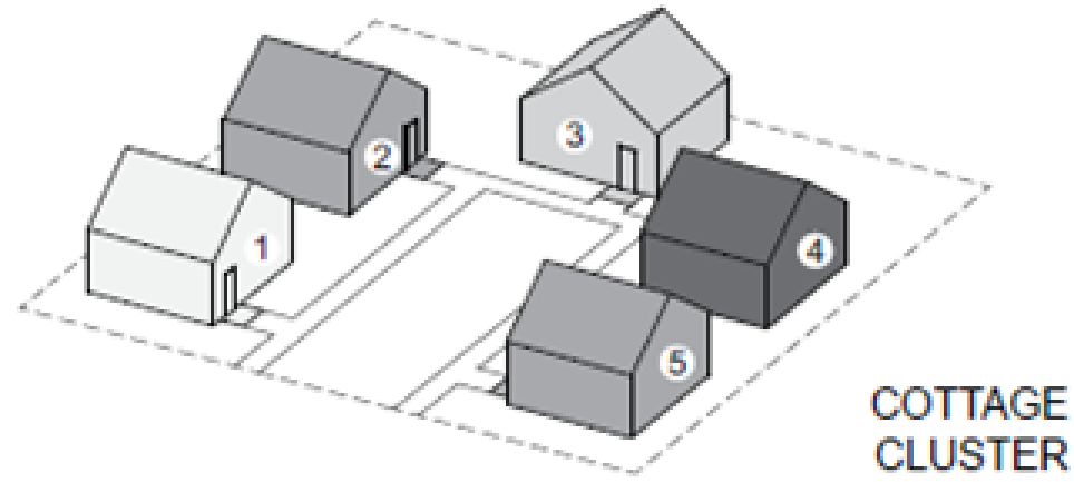
DWELLING, COTTAGE CLUSTER A grouping of no fewer than three detached dwelling units on a single lot, with all dwellings sharing a common open space on the lot, and internal pathways connecting each dwelling to common spaces, shared vehicle parking, and sidewalks.
Cottage Cluster Example:
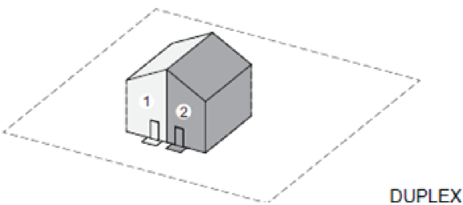
DWELLING, MULTI-UNIT A building containing five or more dwelling units or five or more dwelling units in two or more buildings. Multi-unit dwellings are sited on one property or development site.
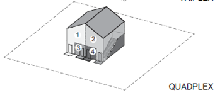
DWELLING, QUADPLEX A detached building on a single lot containing four dwelling units.
Quadplex Example:
DWELLING, SINGLE-UNIT A detached building on a single lot containing one dwelling unit.
DWELLING, TINY HOUSE A detached single-unit dwelling of conventional or modular construction which is up to 800’ square feet in size. Tiny houses are independently habitable and provide the basic requirements of shelter, heating, cooking, water and sanitary sewer utilities. Tiny Houses are subject to the following siting standards:
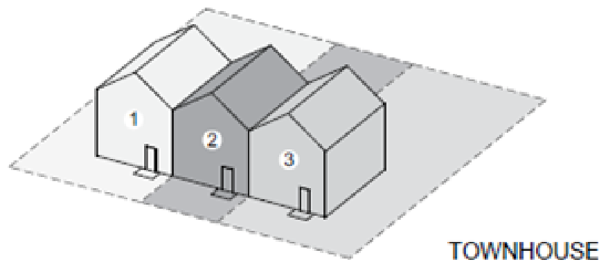
DWELLING, TOWNHOUSE A dwelling unit constructed in a row of two or more attached units in which each unit is built on an individual lot and extends from foundation to roof and with open spaces on at least two sides.
Townhouse Example:
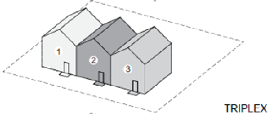
DWELLING, TRIPLEX A detached building on a single lot containing three dwelling units.
Triplex Example:
DWELLING UNIT A single unit providing complete independent living facilities for one or more persons including permanent provisions for living, sleeping, eating, cooking, and sanitation. (2008 Oregon Residential Specialty Code)
ECOSYSTEM The living and non-living components of the environment which interact or function together, including plant and animal organisms, the physical environment, and the energy systems in which they exist. All the components of an ecosystem are inter-related.
ENGINEER A certified geotechnical engineer or a registered professional engineer licensed by the State of Oregon with knowledge and experience relating to geology and geotechnical principles.
ENSURE Guarantee; make sure or certain something will happen.
ESTUARY A body of water semi-enclosed by land, connected with the open ocean, and within which salt water is usually diluted by freshwater derived from the land. The estuary includes:
(a) estuarine water; (b) tidelands; (c) tidal marshes; and (d) submerged lands. Estuaries extend upstream to the head of tidewater.
ESTUARINE ENHANCEMENT An action which results in a long-term improvement of existing estuarine functional characteristics and processes that is not the result of a creation or restoration action.
FARMING, FARM USE The commercial cultivation of the ground; the raising or harvesting of crops or other plants including trees, including uses and structures incidental to the above uses.
FILL The placement by man of sand, sediment, or other material, usually in submerged lands or wetlands, to create new uplands or raise the elevation of land.
FLOODFRINGE The area of the floodplain lying outside of the floodway, but subject to periodic inundation from flooding.
FLOODPLAIN The area adjoining a stream, tidal estuary or coast that is subject to regional flooding.
FLOOD, REGIONAL (100-YEAR) A standard statistical calculation used by engineers to determine the probability of severe flooding. It represents the largest flood which has a one-percent chance of occurring in any one year in an area as a result of periods of higher-than-normal rainfall or stream flows, extremely high tides, high winds, rapid snowmelt, natural stream blockages, tsunamis, or combinations thereof.
FLOODWAY The normal stream channel and that adjoining area of the natural floodplain needed to convey the waters of a regional flood while causing less than one foot increase in upstream flood elevations.
FLOOR AREA The area included in surrounding walls of a building, or portion thereof, exclusive of vent shafts and courts.
FOREDUNE, ACTIVE An unstable barrier ridge of sand paralleling the beach and subject to wind erosion, water erosion, and growth from new sand deposits. Active foredunes may include areas with beach grass and occur in sand spits and at river mouths as well as elsewhere.
FOREDUNE, CONDITIONALLY STABLE An active foredune that has ceased growing in height and that has become conditionally stable with regard to wind erosion.
FOREDUNE, OLDER A conditionally stable foredune that has become wind stabilized by diverse vegetation and soil development.
GABLE The upper, usually triangular part of an end wall enclosed by the sloping ends of a ridged roof.
GEOLOGIC Relating to the occurrence and properties of earth. Geologic hazards include faults, land and mudslides, and earthquakes.
GEOLOGIC HAZARD AREA Geologic Hazard Areas in the City of Gold Beach are areas shown on the Natural Hazard Inventory maps adopted into the Goal 7 Element of the City of Gold Beach Comprehensive Plan, including the Oregon Department of Geology and Mineral Industries (DOGAMI) Bulletin 90 Land-Use Geology of Western City of Gold Beach, Oregon, and the DOGAMI maps known variously as “Further Review Areas.” Geologic Hazard Areas include, but are not limited to,
a) earthflow and slump topography with moderately sloping terrain and irregularities of slope, drainage, or soil distribution;
b) areas of recent earth movement shown by tension cracks, bowed trees and other indicators;
c) steep slope mass movement areas which are areas subject to localized debris slide, debris flow, rockfall, or rock slide;
d) other areas as may be identified by in the preparation of assessments and reports
Geologic Hazard Areas specifically include those areas, which, because of their relation to or location with respect to Geologic Hazard Areas, are in jeopardy of rapidly moving landslides.
GRADE (ground level) The established slope and elevation of the ground around a building to which it is to be filled or cut down, when the grading is done.
GRAVEL SCREENING The operation of portable aggregate screening equipment for the purpose of separating, washing, stockpiling, loading, scaling of sand and gravel products from dredge spoils, but not including crushing.
HEADLANDS Bluffs, promontories or points of high shoreland jutting out into the ocean, generally sloping abruptly into the water. Oregon headlands are generally identified in the report on Visual Resource Analysis of the Oregon Coastal Zone, OCCDC, 1974.
HEALTH CARE ESTABLISHMENT An establishment which provides sleeping and eating facilities to persons receiving medical, obstetrical, or surgical care and nursing service on a continuous basis. Health care establishments also include assisted living facilities.
HEIGHT OF BUILDING The vertical distance from the grade to the highest point of the coping of a flat roof or to the deck line of a mansard roof or to the height of the highest gable of a pitch or hip roof.
HIP The external angle in which adjacent roof slopes meet each other.
HISTORICAL RESOURCES Those districts, sites, buildings, structures, and artifacts which have a relationship to events or conditions of the human past. (See Archaeological Resources definition.)
HOME OCCUPATION Means any business or professional activity engaged in for the production of income by a resident of a dwelling or dwelling unit as a subordinate use of the building and its premises, and in conformance with the standards listed in 3.050. Such term does not include the lease or rental of a dwelling unit or the rental of guest rooms on the same premises.
HOUSEHOLD An individual or two or more persons living together in a dwelling unit.
HUMMOCK, ACTIVE Partially vegetated (usually with beach grass), circular, and elevated mounds of sand which are actively growing in size.
HYDRAULIC Related to the movement or pressure of water. Hydraulic hazards are those associated with erosion or sedimentation caused by the action of water flowing in a river or streambed, or oceanic currents and waves.
HYDRAULIC PROCESSES Actions resulting from the effect of moving water or water pressure on the bed, banks, and shorelands of water bodies (oceans, estuaries, streams, lakes, and rivers).
HYDROGRAPHY The study, description and mapping of oceans, estuaries, rivers and lakes.
HYDROLOGIC Relating to the occurrence and properties of water. Hydrologic hazards include flooding (the rise of water) as well as hydraulic hazards associated with the movement of water.
IMPACT The consequences of a course of action; effect of a goal, guideline, plan or decision.
INTEGRITY The quality or state of being complete and functionally unimpaired; the wholeness or entirety of a body or system, including its parts, materials, and processes. The integrity of an ecosystem emphasizes the interrelatedness of all parts and the unity of its whole.
INTERDUNE AREA Low-lying areas between higher sand landforms and which are generally under water during part of the year. (See also Deflation Plain.)
INTERTIDAL Between the levels of mean lower low tide (MLLT) and mean higher high tide (MHHT).
KENNEL A lot or building in which four or more dogs or cats, four months of age or older, are kept commercially for board, propagation, or sale.
KEY FACILITIES Basic facilities that are primarily planned for by local government but which also may be provided by private enterprise and are essential to the support of more intensive development, including public schools, transportation, water supply, sewage and solid waste disposal.
LCDC The Land Conservation and Development Commission of the State of Oregon. The members appointed by the Governor and confirmed by the Oregon Senate in accordance with the requirements of ORS 197.030.
LIVESTOCK Cows, horses, goats, sheep, pigs, ducks, geese, llamas, alpacas, and other similar animals. Livestock does not include domestic cats, dogs, small birds, rodents, insects, serpents, or other smaller animals normally kept in a dwelling. Backyard chickens are not considered livestock provided they are kept consistent with the standards defined by resolution of the Gold Beach City Council.
Amended October 2012 (Ordinance No. 641)
LITTORAL DRIFT The material moved, such as sand or gravel, in the littoral (shallow water nearshore) zone under the influence of waves and currents.
LOT A parcel or tract of land.
LOT COVERAGE That percentage of a total gross acreage (from ACREAGE, NET definition) which, when viewed directly from above, would be IMPERVIOUS SURFACE(S) such as a building or structure, paved driveways, sidewalks, or other similar non-pervious surfaces.
LOT, CORNER A lot abutting on two intersecting streets neither of which is an angle greater than 135 degrees.
LOT, DEPTH The horizontal distance from the midpoint of the front lot line to the midpoint of the rear lot line.
LOT, INTERIOR A lot other than a corner lot.
LOT LINE The property line bounding a lot.
LOT LINE, FRONT In the case of an interior lot, the lot lines separating the lot from the street other than an alley, and in the case of a corner lot, the shortest lot line along a street other than an alley.
LOT LINE, REAR A lot line which is opposite and most distant from the front lot line, and in the case of an irregular, triangular, or other shaped lot, a line 10 feet in length within the lot parallel to and at a maximum distance from the front lot line(s).
LOT LINE, SIDE Any lot line not a front or rear lot line.
LOT LINE, STREET SIDE In the case of a corner lot or multiple-frontage lot, a lot line along a street other than an alley that is not the front lot line.
LOT WIDTH The average horizontal distance between the side lot lines, excluding appendages of less than 30 feet in width.
MAINTAIN Support, keep, and continue in an existing state or condition without decline.
MANAGEMENT UNIT A discrete geographic area, defined by biophysical characteristics and features, within which particular uses and activities are promoted, encouraged, protected, or enhanced, and others are discouraged, restricted, or prohibited.
MANUFACTURED DWELLING PARK means any place where four or more manufactured dwellings or prefabricated structures, as defined in ORS 455.010, that are relocatable and more than eight and one-half feet wide, are located within 500 feet of one another on a lot, tract or parcel of land under the same ownership, the primary purpose of which is to rent or lease space or keep space for rent or lease to any person for a charge or fee paid or to be paid for the rental or lease or use of facilities or to offer space free in connection with securing the trade or patronage of such person.
Manufactured dwelling park does not include a lot or lots located within a subdivision being rented or leased for occupancy by no more than one manufactured dwelling per lot if the subdivision was approved by the local government unit having jurisdiction under an ordinance adopted pursuant to ORS 92.010 to 92.192. ORS 446.003(22)(a-b)
MANUFACTURED HOME A structure constructed for movement on the public highways that has sleeping, cooking and plumbing facilities, that is intended for human occupancy, that is being used for residential purposes and that was constructed in accordance with federal manufactured housing construction and safety standards and regulations in effect at the time of construction. ORS 446.003(23)(a)
MARIJUANA The plant Cannabis family Cannabaceae, any part of the plant Cannabis family Cannabaceae and the seeds of the plant Cannabis family Cannabaceae.
Amended December 2016 (Ordinance No. 661)
MARIJUANA FACILITY A Medical Marijuana Grow Site, a Medical Marijuana Processing Site, a Medical Marijuana Dispensary, a Recreational Marijuana Producer, a Recreational Marijuana Processor, a Recreational Marijuana Wholesaler or a Recreational Marijuana Retailer.
MEDICAL MARIJUANA DISPENSARY A medical marijuana dispensary registered with the Oregon Health Authority pursuant to ORS 475B.450.
MEDICAL MARIJUANA GROW SITE A medical marijuana grow site registered with the Oregon Health Authority pursuant to ORS 475B.420.
MEDICAL MARIJUANA PROCESSING SITE A medical marijuana processing site registered with the Oregon Health Authority pursuant ORS 475B.435.
RECREATIONAL MARIJUANA PROCESSOR A recreational marijuana processor licensed by the Oregon Liquor Control Commission pursuant to ORS 475B.090.
RECREATIONAL MARIJUANA PRODUCER A recreational marijuana producer licensed by the Oregon Liquor Control Commission pursuant to ORS 475B.070.
RECREATIONAL MARIJUANA RETAILER A recreational marijuana retailer licensed by the Oregon Liquor Control Commission pursuant to ORS 475B.110.
RECREATIONAL MARIJUANA WHOLESALER A recreational marijuana wholesaler licensed by the Oregon Liquor Control Commission pursuant to ORS 475B.100.
MITIGATION The creation, restoration, or enhancement of an estuarine area to maintain the function characteristics and processes of the estuary, such as its natural biological productivity, habitats, species diversity, unique features and water quality; and for riparian vegetation shall mean taking one or more of the following actions listed in order of priority:
- a) Avoiding the impact altogether by not taking certain development action or parts of that action;
- b) Minimizing impacts by limiting the degree or magnitude of the development action and its implementation;
- c) Rectifying the impact by repairing, rehabilitating or restoring the affected environment;
- d) Reducing or eliminating the impact over time by preservation and maintenance operations during the life of the development action by monitoring and taking appropriate corrective measures;
- e) Compensating for the impact by placing or providing comparable substitute resources or environments.
MOBILE HOME means a structure constructed for movement on the public highways that has sleeping, cooking and plumbing facilities, that is intended for human occupancy, that is being used for residential purposes and that was constructed between January 1, 1962, and June 15, 1976, and met the construction requirements of Oregon mobile home law in effect at the time of construction. ORS 446.003(27)
MOBILE HOME OFFICE A mobile home that has been modified for office use that complies with City of Gold Beach Building Codes.
MOBILE HOME PARK means any place where four or more manufactured dwellings, recreational vehicles as defined in ORS 174.101, or a combination thereof, are located within 500 feet of one another on a lot, tract or parcel of land under the same ownership, the primary purpose of which is to rent space or keep space for rent to any person for a charge or fee paid or to be paid for the rental or use of facilities or to offer space free in connection with securing the trade or patronage of such person.
Mobile Home Park does not include a lot or lots located within a subdivision being rented or leased for occupancy by no more than one manufactured dwelling per lot if the subdivision was approved by the municipality unit having jurisdiction under an ordinance adopted pursuant to ORS 92.010 to 92.192. ORS 446.003(28)
NATURAL AREAS Includes land and water that has substantially retained its natural character, which is an important habitat for plant, animal, or marine life. Such areas are not necessarily completely natural or undisturbed, but can be significant for the study of natural, historical, scientific, or paleontological features, or for the appreciation of natural features.
NATURAL RESOURCES Air, land and water and the elements thereof which are valued for their existing and potential usefulness to man.
NONCONFORMING USE OR STRUCTURE Otherwise known as “Grandfathering.” A lawful existing structure or use at the time this ordinance or any amendment thereto becomes effective, that does not conform to the requirements of the zone in which it is located.
OCEAN FLOODING The flooding of lowland areas by salt water owing to tidal action, storm surge, or tsunamis (seismic sea waves). Land forms subject to ocean flooding include beaches, marshes, coastal lowlands, and low-lying interdune areas. Areas of ocean flooding are mapped by the Federal Emergency Management Agency (FEMA). Ocean flooding includes areas of velocity flooding and associated shallow marine flooding.
OVERLAY ZONE Overlay zones impose and/or relax requirements of an underlying land use district, or base zone, where characteristics of the land or neighborhood, or the types of development planned for an area require special regulations.
PARKING SPACE A rectangle, not less than 18 feet long and 9 feet wide which is available for the placement of operable motor vehicles of residents, customers, patrons, visitors, employees and all other persons entering a premise.
PARKING SPACE, HANDICAP A special parking space identified suitably for the handicapped by appropriate signage that is a minimum of 18 feet long and 17 feet wide to be used in conjunction with public and government buildings subject to the state building code. The space shall meet the requirements for size and signage pursuant to ORS Chapter 447. The width requirement may include a sidewalk.
PLANNED UNIT DEVELOPMENT A single development in which a combination of uses compatible with the comprehensive plan in terms of land use and density of development is permissible subject to the procedural requirements of the zoning and subdivision ordinances.
Planned Unit Developments include condominiums, planned communities, and any other development which may include common ownership of structures or land.
PLANNING AREA The air, land and water resources within the jurisdiction of a governmental agency.
PLANNING DIRECTOR The person acting as Planning Director for the City of Gold Beach or his or her designee.
POLLUTION The violation or threatened violation of applicable state or federal environmental quality statutes, rules and standards.
PRESERVE To save from change or loss and reserve for a special purpose.
PROGRAM Proposed or desired plan or course of proceedings and action.
PROTECT Save or shield from loss, destruction, or injury or for future intended use.
PROVIDE Prepare, plan for, and supply what is needed.
PUBLIC FACILITIES AND SERVICES Projects, activities and facilities which the planning agency determines to be necessary for the public health, safety and welfare.
PUBLIC GAIN The net gain from combined economic, social, and environmental effects which accrue to the public because of a use or activity and its subsequent resulting effects.
RECREATION Any experience voluntarily engaged in largely during leisure (discretionary time) from which the individual derives satisfaction. Coastal Recreation occurs in offshore ocean waters, estuaries, and streams, along beaches and bluffs, and in adjacent shorelands. It includes a variety of activities, from swimming, scuba diving, boating, fishing, hunting, and use of dune buggies, shell collecting, painting, wildlife observation, and sightseeing, to coastal resorts and water-oriented restaurants.
Low-Intensity Recreation does not require developed facilities and can be accommodated without change to the area or resource. For example, boating, hunting, hiking, wildlife photography, and beach or shore activities can be low-intensity recreation.
High-Intensity Recreation uses specially built facilities, or occurs in such density or form that it requires or results in a modification of the area or resource. Campgrounds, golf courses, public beaches, and marinas are examples of high-intensity recreation.
RECREATIONAL VEHICLE Means a unit, with or without motive power, which is designated for human occupancy, is used temporarily for recreational or emergency purposes. Recreational vehicles include:
- (a) "Camping Trailer" means a vehicle unit mounted on wheels and constructed with collapsible partial side walls which fold when the unit is towed by another vehicle and unfold at the campsite to provide temporary living quarters for recreational, camping or travel use, and has a floor area of less than 220 square feet, excluding built-in equipment such as wardrobes, closets, cabinets, kitchen units or fixtures and bath or toilet rooms;
- (b) "Motor Home" means a vehicular unit built on or permanently attached to a self-propelled motor vehicle chassis or on a chassis cab or van which is an integral part of the complete vehicle, and has a floor area of less than 220 square feet, excluding built-in equipment such as wardrobes, closets, cabinets, kitchen units or fixtures and bath or toilet rooms;
- (c) "Park Trailer" means a vehicle built on a single chassis, mounted on wheels, designed to provide seasonal or temporary living quarters which may be connected to utilities for operation of installed fixtures and appliances, of such a construction as to permit set-up by persons without special skills using only hand tools which may include lifting, pulling and supporting devices and a gross trailer area not exceeding 400 square feet when in the set-up mode;
- (d) "Travel Trailer" means a vehicular unit which has a roof, floor and sides and is mounted on wheels, but which is not of such size or weight as to require special highway movement permits when towed by a motorized vehicle, and has a floor area of less than 220 square feet, excluding built-in equipment such as wardrobes, closets, cabinets, kitchen units or fixtures and bath or toilet rooms;
- (e) "Truck Camper" means a portable unit which has a roof, floor and sides and is designed to be loaded on and off the bed of a truck or pick-up truck, and has a floor area of less than 220 square feet, excluding built-in equipment such as wardrobes, closets, cabinets, kitchen units or fixtures and bath or toilet rooms.
RECREATIONAL VEHICLE PARK A commercially developed area devoted to overnight temporary use for vacation or recreational purposes. Accessory uses within a park shall be limited to those uses that are allowed by the zoning designation in which the park is located. One dwelling for a manager shall be allowed on the park site.
RESIDENTIAL FACILITY Means a residential care, residential training or residential treatment facility, as those terms are defined in ORS 443.400, that provides residential care alone or in conjunction with treatment or training or a combination thereof for six to fifteen individuals who need not be related. Staff persons required to meet licensing requirements shall not be counted in the number of facility residents, and need not be related to each other or to any resident of the residential facility.
RESIDENTIAL HOME Means a residential treatment or training home, as defined in ORS 443.400, a residential facility registered under ORS 443.480 to 443.500 or an adult foster home licensed under ORS 443.705 to 443.825 that provides residential care alone or in conjunction with treatment or training or a combination thereof for five or fewer individuals who need not be related. Staff persons required to meet licensing requirements shall not be counted in the number of facility residents, and need not be related to each other or to any resident of the residential home.
RESTORE Revitalizing, returning, or replacing original attributes and amenities, such as natural biological productivity, aesthetic and cultural resources, which have been diminished or lost by past alterations, activities, or catastrophic events. For the purposes of Goal 16 estuarine restoration means to revitalize or reestablish functional characteristics and processes of the estuary diminished or lost by past alterations, activities, or catastrophic events. A restored area must be a shallow subtidal or an intertidal or tidal marsh area after alteration work is performed, and may not have been a functioning part of the estuarine system when alteration work began.
Active Restoration involves the use of specific positive remedial actions, such as removing fills, installing water treatment facilities, or rebuilding deteriorated urban waterfront areas.
Passive Restoration is the use of natural processes, sequences, and timing which occurs after the removal or reduction of adverse stresses without other specific positive remedial action.
RIPARIAN Of, pertaining to, or situated on the edge of the bank of a river or other body of water.
RIPARIAN AREA The area adjacent to a river, lake, stream or wetland consisting of the area of transition from aquatic ecosystem to a terrestrial ecosystem.
RIPRAP A layer, facing, or protective mound of stones randomly placed to prevent erosion, scour or sloughing of a structure or embankment; also, the stone so used. In local usage, the similar use of other hard material, such as concrete rubble, is also frequently included as riprap.
ROADSIDE STAND A temporary structure designed for the purpose of retail sales.
SEDENTARY Attached firmly to the bottom, generally incapable of movement.
SETBACK The distance from the right of way or easement boundary of a public or private road or other easement or from a lot line, to any point of a building.
SHORELINE The boundary line between a body of water and the land, measured on tidal waters at mean higher high water, and on non-tidal waterways at the ordinary high-water mark.
SHORT-TERM RENTAL (STR) Also referred to as a Vacation Rental - means a house, duplex, condominium, houseboat, trailer, or other one & two family residential dwelling units where a person rents a guest bedroom or the entire residential dwelling unit for transient lodging occupancy.
Amended May 2021 (Ordinance No. 677)
SIGN A presentation or representation, other than a house number, by words, letters, figures, designs, pictures, or colors publicly displayed so as to give notice relative to a person, a business, an article or merchandise, a service, an assemblage, a solicitation or a request for aid or other type of advertising. This includes the surface upon which the representation is displayed.
SIGNIFICANT HABITAT AREAS A land or water area where sustaining the natural resource characteristics is important or essential to the production and maintenance of aquatic life or wildlife populations.
SOCIAL CONSEQUENCES The tangible and intangible effects upon people and their relationships with the community in which they live resulting from a particular action or decision.
STREET The entire width between the boundary lines of every way which provides for public use for the purpose of vehicular and pedestrian traffic and including, but not limited to, "roads," "highways," "lanes," "places," "avenues" and "alleys".
STRUCTURAL ALTERATION Any change to the supporting members of a structure including foundation, bearing walls, or partitions, columns, beams or girders, or any structural change in the roof.
STRUCTURE Anything constructed or installed or portable, the use of which requires a location on a parcel of land.
SUBSTANTIAL CONSTRUCTION Obtaining all necessary permits to commence construction or to commence the principal activity approved by a conditional use permit.
SUBSTRATE The medium upon which an organism lives and grows. The surface of the land or bottom of a water body.
SUBTIDAL Below the level of mean lower low tide (MLLT).
TEMPORARY ALTERATION Dredging, filling, or another estuarine alteration occurring over a specified short period of time which is needed to facilitate a use allowed by an acknowledged plan. Temporary alterations may not be for more than three years and the affected area must be restored to its previous condition. Temporary alterations include: (1) alterations necessary for federally authorized navigation projects (e.g., access to dredged material disposal sites by barge or pipeline and staging areas or dredging for jetting maintenance), (2) alterations to establish mitigation sites, alterations for bridge construction or repair and for drilling or other exploratory operations, and (3) minor structures (such as blinds) necessary for research and educational observation.
TERRITORIAL SEA The ocean and seafloor area from mean low water seaward three nautical miles.
TIDAL MARSH Wetlands from lower high water (LHW) inland to the line of non-aquatic vegetation.
TOP OF BANK Shall have the same meaning as “bankfull stage” defined in OAR 141-085-0010 (2). Meaning the stage or elevation at which water overflows the natural banks of streams or other waters of this state and begins to inundate the upland. In the absence of physical evidence, the two year-recurrence interval flood elevation may be used to approximate the bankfull stage.
URBAN LAND Land inside an urban growth boundary.
URBANIZABLE LAND Urban land that, due to the present unavailability of urban facilities and services, or for other reasons, either:
- (a) Retains the zone designations assigned prior to inclusion in the boundary, or
- (b) Is subject to interim zone designations intended to maintain the land’s potential for planned urban development until appropriate public facilities and services are available or planned.
USE The purpose for which land or a structure is designed, arranged, or intended, or for which it is occupied or maintained.
WATER-DEPENDENT A use or activity which can be carried out only on, in, or adjacent to water areas because the use requires access to the water body for water-borne transportation, recreation, energy production, or source of water.
WATER ORIENTED A use whose attraction to the public is enhanced by a view of or access to coastal waters.
WETLANDS Land areas where excess water is the dominant factor determining the nature of soil development and the types of plant and animal communities living at the soil surface. Wetland soils retain sufficient moisture to support aquatic or semi-aquatic plant life. In marine and estuarine areas, wetlands are bounded at the lower extreme by extreme low water; in freshwater areas, by a depth of six feet. The areas below wetlands are submerged lands.
YARD An open space on a lot which is unobstructed from the ground upward, except as otherwise provided in this ordinance.
YARD, FRONT A yard between side lot lines and measured horizontally at right angles to the front lot line to the nearest point of any building.
YARD, REAR A yard extending between side lot lines and measured horizontally at right angles to the rear lot line from the rear lot line to the nearest point of any building.
YARD, SIDE An open space between the front and rear yards measured horizontally and at right angles from the side lot line to the nearest point of any building.
ZONING REQUIREMENT Means any standard, criteria, condition, review procedure, permit requirement or other requirement adopted by a city or county under the authority of ORS chapter 215 or 227 that applies to the approval or siting of a residential facility or residential home. A zoning requirement does not include a state or local health, safety, building, occupancy or fire code requirement.
§ 1.040Compliance with Ordinance Provisions
§ 1.050Classification of Zones
For the purpose of this ordinance, the city or portion thereof is divided into zones designated as follows:
§ 1.060Location of Zones
The boundaries for the zones listed in this ordinance are indicated on the city zoning map which is hereby adopted and made a part of this ordinance by this reference. The boundaries may be modified in accordance with zoning map amendments which may be adopted by reference.
§ 1.070Zoning Map
A zoning map amendment adopted by section 1.060 of this ordinance or by an amendment thereto shall be prepared by authority of the Planning Commission or be a modification by the City Council of a map or map amendment so prepared. The map or map amendment shall be dated with the effective date of the ordinance that adopts the map or map amendment. A certified print of the adopted map or map amendment shall be maintained in the office of the City Recorder as long as this ordinance remains in effect.
Article IIUse Zones
Residential Zone (R)
§ 2.010Purpose of Classification
The R zone is designated to be applied to residential areas to accommodate a variety of housing types and to reduce the impacts of such developments on surrounding existing homes or neighborhoods.
§ 2.020Uses Permitted Outright
In the R zone, the following uses and their accessory uses are permitted outright:
Detached single-unit dwelling.
Manufactured home or TINY HOUSE
Amended December 2016 (Ordinance No. 660)
Duplex
Triplex
Quadplex
Townhouses
Cottage cluster, subject to the standards in Section 2.070.
Multi-unit dwellings, subject to the standards in Section 2.075.
Mobile or manufactured home park
The temporary use of a recreational vehicle by the lot owner, family of the lot owner or nonpaying guests of the lot owner. The use is deemed to be temporary if the recreational vehicle is occupied for fewer than 15 consecutive days in any 30-day period.
Non-commercial farming where the parcel is one (1) acre or more, but not including livestock.
Amended December 2016 (Ordinance No. 660)
Home Occupations subject to the general standards listed in Section 3.050.
A Residential Home as defined in ORS 197.660(2).
A Residential Facility as defined in ORS 197.660(1).
Registered or certified family childcare home pursuant to ORS 657A.440.
Accessory Dwelling Unit (ADU) subject to the specific standards listed in Section 3.040.
Bees. The keeping or maintaining of bees, bee colonies, beehives, combs, or containers of any kind or character wherein bees are hived is subject to the following:
No more than three (3) bee colonies shall be kept or maintained on properties of less than one acre.
No more than five (5) bee colonies shall be kept or maintained on properties of one acre or greater.
Bee colonies shall be kept in hives with removable frames, which shall be kept in sound and usable condition.
For each colony permitted to be maintained under this ordinance, there may also be maintained upon the same property, one nucleus colony in a hive structure not to exceed one standard 9-5/8 inch depth 10-frame hive body.
In each instance where a colony is kept less than twenty five (25) feet from a property line, a flyway barrier at least six (6) feet in height shall be maintained parallel to the property line for a minimum of ten (10) feet in either direction from the hive The flyway barrier may consist of a wall, fence, dense vegetation or a combination there of, such that bees will fly over rather than through the material to reach the colony.
A constant supply of fresh water shall be provided for the colonies on site within fifteen (15) feet of each hive.
Each beekeeper shall ensure that no wax comb or other material that might encourage robbing by other bees are left upon the grounds of the property. Such materials once removed from the site shall be handled and stored in sealed containers or placed within a building or other insect proof container.
If the beekeeper serves the community by removing a swarm or swarms of honey bees from locations where they are not desired, the beekeeper shall be permitted to temporarily house the swarm on the property for no more than 60 days from the date acquired. If the beekeeper is not at hive capacity shall be permitted to keep the hive permanently.
Africanized bees are prohibited.
The sale of surplus honey or bee’s wax produced on site shall be permitted on the property where the keeping of bees is permitted provided the property owner meets the general Home Occupation standards in Section 3.050.
Amended May 2015 (Ordinance No. 655)
Use of existing dwelling unit within a one-or-two family residential dwelling unit as a Short-Term Rental (STR), also known as vacation rental dwelling, subject to compliance with the City Business Code requirements for STRs.
Amended May 2021 (Ordinance No. 677)
§ 2.025Procedure Types for Permitted Uses
In the R zone, uses permitted outright, as provided in Section 2.020, are subject to the following review procedures:
Any residential development of four or fewer dwelling units, accessory dwelling units, and Residential Homes are subject to Type I Development Review, pursuant to Section 11.020. This includes: a development with up to four detached single-unit dwellings, manufactured homes, tiny houses, or townhouses; duplexes; triplexes; quadplexes; and cottage clusters up to four units.
Any residential development of five to 20 units and Residential Facilities are subject to Type II Development Review, pursuant to Section 11.030. This includes: a development with five to 20 detached single-unit dwellings, manufactured homes, tiny houses, or townhouses; cottage clusters with five or more units; multi-unit dwellings up to 20 units; and mobile or manufactured home parks up to 20 units.
Any residential development of more than 20 units, and any development subject to an Overlay Designation pursuant to GBZO Article II A, is subject to Type III Development Review, pursuant to Section 11.040. This includes: a development with more than 20 detached single-unit dwellings, manufactured homes, tiny houses, or townhouses; multi-unit dwellings over 20 units; and mobile or manufactured home parks over 20 units.
All other permitted uses under Section 2.020 are exempt from Development Review.
§ 2.030Conditional Uses Permitted
In the R zone, the following uses and their accessory uses are permitted when authorized in accordance with Section 6.010 through Section 6.050. All conditional uses must meet the general standards of Section 6.041. Numbers in parenthesis following a use indicate the specific standards described in Section 6.042 that must be met in addition to the general standards in order to approve that particular use.
Place of worship, school, grange hall or community building.
Public use facility or public utility, including but not limited to fire stations and parks.(1)
Recreational vehicle temporarily used during construction of a permitted use for a period not to exceed twelve months.
Utility facility, including substation or pumping station or private generator. (1)
Communications transmitter, receiver, antenna or tower. (1)
Planned Unit Development in compliance with Article V.
Wind generators (1).
Home occupations not meeting the general standards of Section 3.050.
One manufactured home or mobile home in conjunction with an existing dwelling as a temporary use for the term of a hardship suffered by the existing resident or a relative of the resident. (5)
Private horse stable where the lot or parcel is one acre or more in size but not including the renting or boarding of horses for profit.
Medical or dental clinic, acute and continuing care facilities regulated by the Oregon Health Authority, and long-term care facilities regulated by the Oregon Department of Human Services.
§ 2.040Lot size
Except as provided in Sections 4.040 and 4.050 in the R zone, the minimum lot area and dimensions shall be as follows:
| Minimum Lot Area (square feet) | Minimum Lot Width (feet) | Minimum Lot Depth (feet) | |
|---|---|---|---|
| Detached single-unit dwelling or manufactured dwelling | 3,000 | 30 | 60 |
| Tiny house | 2,400 | 20 | 60 |
| Duplex | 3,000 | 35 | 60 |
| Triplex | 5,000 | 40 | 60 |
| Quadplex | 7,000 | 40 | 60 |
| Townhouses | 1,700 | 20 | 60 |
| Cottage cluster | 7,000 | 40 | 60 |
| Multi-unit dwellings | N/A | N/A | N/A |
| Mobile or manufactured home park | 8,000 total or 2,000 per home space, whichever is greater | 40 | 60 |
Lot sizes suitable for building shall be dependent on the availability of public water and sewage systems. The minimum lot area standards above apply when both a public water and sewage system are available. If the lot is not served by both a public water and sewer system, the lot area shall conform to the state and county requirements for water supply and sewage disposal.
§ 2.045Minimum and Maximum Residential Density
New residential development in the R zone shall be subject to the following minimum and maximum residential density standards. Refer to the definition of “acreage, net” in Section 1.030.
| Minimum Net Density | Maximum Net Density | |
|---|---|---|
| Detached single-unit dwelling, manufactured dwelling, tiny house, duplex, triplex, and quadplex | N/A | N/A (based on minimum lot area) |
| Townhouses | N/A | 25 units per net acre |
| Cottage cluster | 8 units per net acre | 20 units per net acre |
| Multi-unit dwellings | N/A | 30 units per net acre |
| Mobile or manufactured home park | N/A | 20 units per net acre |
§ 2.050Set-Back Requirements
Except as provided in Section 4.010 and 4.030 in the R zone, minimum yard setbacks shall be provided as follows:
The front yard shall be a minimum of ten (10) percent of the lot depth, or ten (10) feet, whichever is less.
The interior side yard shall be a minimum of five (5) feet, except that along a side lot line where townhouse dwellings are attached, the minimum set-back shall be zero (0) feet.
Spacing between buildings on the same site or part of the same development shall be a minimum of six (6) feet.
§ 2.060Height of Buildings
Except as provided in Section 4.020 in the R zone, maximum building height shall be as follows:
| Maximum Building Height | |
|---|---|
| Detached single-unit dwelling, manufactured dwelling, tiny house, townhouses, and cottage cluster | 25 feet; 35 feet if a garage is provided |
| Duplex, triplex, quadplex, and multi-unit dwellings | 35 feet |
| Mobile or manufactured home park | N/A |
| Other uses | 25 feet |
§ 2.065Lot Coverage
In the R zone, maximum lot coverage shall be as follows:
| Maximum Lot Coverage | |
|---|---|
| Detached single-unit dwelling, manufactured dwelling | 65% |
| Duplex, triplex, and quadplex | 70% |
| Townhouses | 75% |
| Cottage cluster | 65% |
| Multi-unit dwellings | 65% |
| Mobile or manufactured home park | N/A |
| Other uses | N/A |
§ 2.070Development Standards for Cottage Clusters
Cottage cluster development shall comply with all of the following standards:
Average Dwelling Size. The maximum average dwelling size permitted for a cottage cluster is 1,400 square feet. For the purposes of this standard, “Average dwelling size” means the average square footage of all dwelling units and any community building in the cottage cluster.
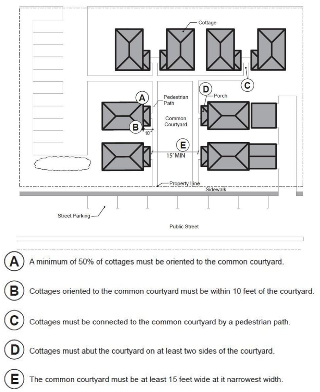
Cottage Orientation. Cottages must be clustered around a common open space (common courtyard) and must meet the following standards (see Figure 2.070-1):
Each cottage must either abut the common courtyard or must be directly connected to it by a pedestrian path.
A minimum of 50 percent of cottages within a cluster must be oriented to the common courtyard and must:
Have a main entrance facing the common courtyard;
Be within 10 feet from the common courtyard, measured from the façade of the cottage to the nearest edge of the common courtyard; and
Be connected to the common courtyard by a pedestrian path.
Cottages not facing the common courtyard, or the street must have their main entrances facing a pedestrian path that is directly connected to the common courtyard.
Common Courtyard Design Standards. Each cottage cluster must share a common courtyard. Common courtyards must meet the following standards (see Figure 2.070-1):
The common courtyard must be a single, contiguous piece.
Cottages must abut the common courtyard on at least two sides of the courtyard.
The common courtyard must contain a minimum of 150 square feet per cottage.
The common courtyard must be a minimum of 15 feet wide at its narrowest dimension.
The common courtyard shall be developed with a mix of landscaping, lawn area, pedestrian paths, and/or paved courtyard area, and may also include recreational amenities. Impervious elements shall not exceed 75 percent of the total common courtyard area.
Pedestrian paths that are contiguous to a common courtyard shall count toward the courtyard’s minimum dimension and area. Parking areas, required setbacks, and driveways do not qualify as part of a common courtyard.
Community Buildings. Cottage cluster projects may include community buildings for the shared use of residents that provide space for accessory uses such as community meeting rooms, guest housing, exercise rooms, day care, or community eating areas. Community buildings must meet the following standards:
Each cottage cluster is permitted one community building.
The community building shall count towards the maximum average floor area, pursuant to subsection 2.070.2.
Pedestrian Access.
An accessible pedestrian path must be provided that connects the main entrance of each cottage to the following:
The common courtyard;
Shared parking areas;
Community buildings; and
Sidewalks in public rights-of-way abutting the site or rights-of-way if there are no sidewalks.
The pedestrian path must be hard-surfaced and a minimum of four (4) feet wide.
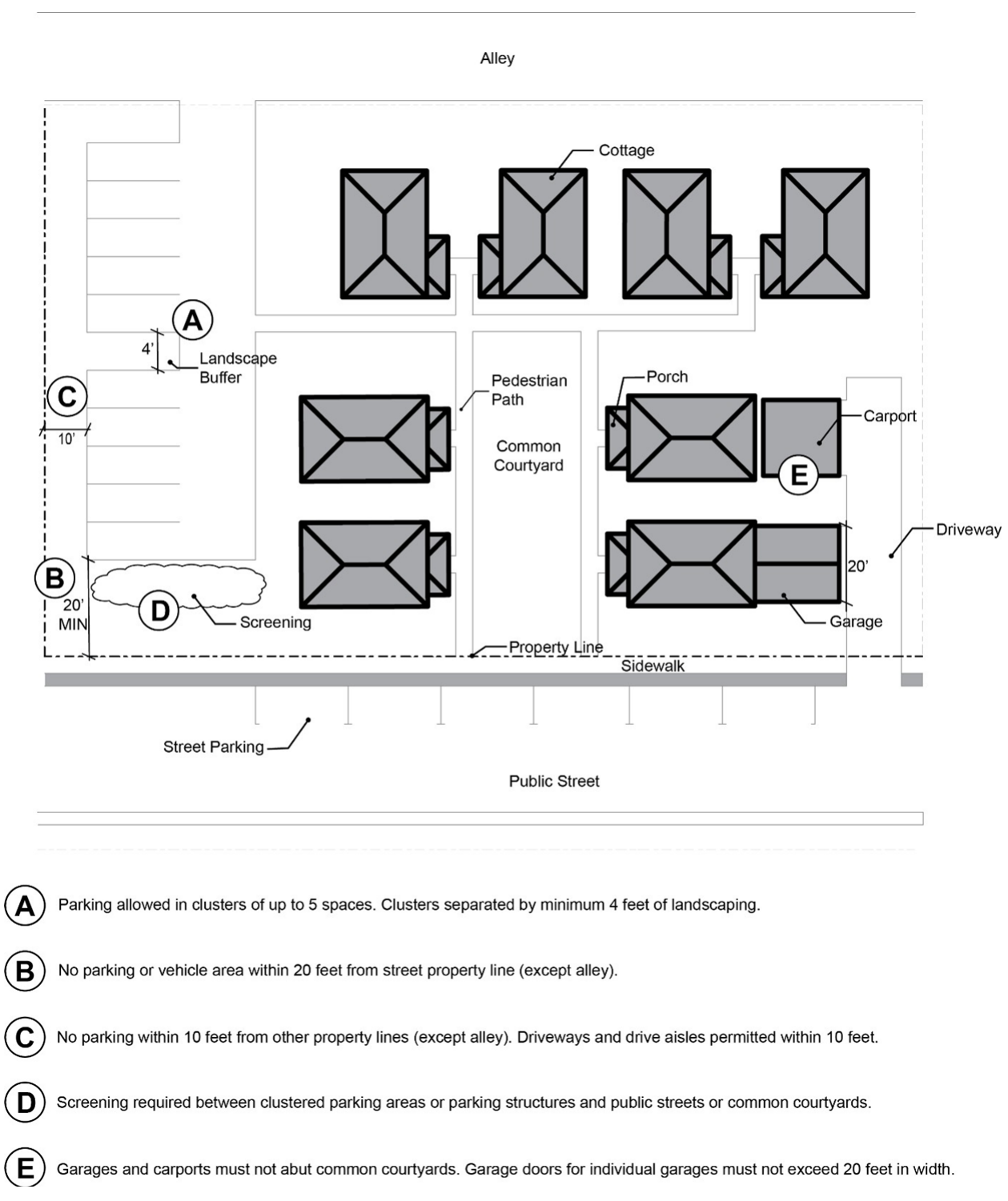
Parking Design (see Figure 2.070-2).
Off-street parking may be provided with individual cottages or arranged in clusters (shared parking areas).
Clustered parking. If clustered parking is proposed, it must meet the following standards:
A parking cluster must not exceed five (5) contiguous spaces.
Parking clusters must be separated from other spaces by at least four (4) feet of landscaping.
Clustered parking areas may (or may not) be covered.
Parking areas must also meet the Standards for Off-Street Parking Facilities in Section 3.033.
Parking location and access.
Off-street parking spaces and vehicle maneuvering areas shall not be located:
Off-street parking spaces shall not be located within 10 feet of any other property line, except alley property lines. Driveways and drive aisles are permitted within 10 feet of other property lines.
Screening. Landscaping, fencing, or walls at least three feet tall shall separate clustered parking areas and parking structures from common courtyards and public streets.
Garages and carports.
Garages and carports (whether shared or individual) must not abut common courtyards.
Individual detached garages must not exceed 400 square feet in floor area.
Garage doors for attached and detached individual garages must not exceed 20 feet in width.
Accessory Structures. Accessory structures must not exceed 400 square feet in floor area.
Existing Structures. On a lot or parcel to be used for a cottage cluster development, an existing detached single-unit dwelling on the same lot at the time of proposed development of the cottage cluster may remain within the cottage cluster development area under the following conditions:
The existing dwelling may be nonconforming with respect to the requirements of this Section 2.070.
The floor area of the existing dwelling shall not count towards the maximum average dwelling size of a cottage cluster.
The existing dwelling shall be excluded from the calculation of orientation toward the common courtyard, per subsection 2.070.3.b.
§ 2.075Development Standards for Multi-Unit Dwellings
Development of multi-unit dwellings shall comply with all of the following standards:
Building Orientation.
For multi-unit dwellings with a shared entrance(s), the primary entrance shall face the front property line, unless one of the following circumstances applies:
Buildings on corner lots may have the main entrance facing either street or the intersection of the streets.
Buildings with more than one main entry may have only one entrance facing the front property line.
Building entrances that face a landscaped shared courtyard are exempt from this requirement.
For multi-unit dwellings with individual entries, the primary entrance to each dwelling shall either face the street, be at an angle of no more than 45 degrees from the street, or open to a porch. Building entrances that face a landscaped shared courtyard are exempt from this requirement. If the entrance opens to a porch, the porch shall meet all of the following standards:
Have a minimum area of 25 square feet, with a minimum depth of five (5) feet.
Have at least one porch entry facing the street; and
Have a roof that is a maximum of 12 feet above the floor of the porch; and that covers at least 30% of the porch area.
Windows. At least 15 percent of the area of each street-facing facade must be windows or main entrance doors, in compliance with the following standards:
Window area is considered the entire area within the outer window frame, including any interior window grid.
All of the window area of the street-facing wall(s) of an attached garage, and half of the total window area in the door(s) of an attached garage may be counted toward this standard.
Detailed Design. Multi-unit building designs shall incorporate not fewer than five (5) architectural features from the following list of elements on each façade facing a street or commonly-accessible open space.
Covered front porch with a minimum area of 25 square feet and a minimum depth of five (5) feet.
Recessed entrance at least three (3) feet deep.
Windows covering at least [30] percent of surface area of all street-facing elevation
Window trim around all windows on a façade with a minimum width of three (3) inches and a minimum thickness of 5/8 inches.
Recesses in all windows on a façade of at least three (3) inches as measured horizontally from the face of the façade.
Mullions or window grids in all windows on a façade.
Bay window at least six (6) feet wide, bumped out by at least two (2) feet; and extending from the top of the foundation to the top of the main façade wall.
A minimum of three gable end brackets (either triangular knee braces or rake brackets), spaced a maximum of 15 feet on center.
Gabled dormer at least four (4) feet wide and integrated into the roof form.
An offset on the building face of at least 16 inches from 1 one exterior wall to the other.
Roof eaves on all elevations that project at least 12 inches from the intersection of the roof and the exterior walls.
Roof line offset of at least two (2) feet from the top surface of one roof to the top surface of the other.
Other feature not listed but providing visual relief or contextually appropriate design similar to options a-l, if requested by the applicant and approved by the Planning Director as part of a discretionary review.
Articulation. When the front, side, or rear elevation of any multi-unit building is more than 600 square feet in area, that elevation must be divided into distinct planes of not more than 600 square feet subject to the following standards:
Areas of wall planes that are entirely separated from other wall planes (by use of wall or roof offsets, bays, stoops, canopies, porches, balconies, chimneys, dormers, and similar architectural projections or recesses) are those that are separated from the adjacent building plane by a depth of not less than two (2) feet for a length of not less than six (6) feet.
Where horizontal features such as cornices, pediments, belt courses, canopies or covered porches, or bellybands are used to break a wall plane, they must be at least one foot in height across the width of the elevation.
Roofs must provide offsets or breaks in the roofline with at least one offset for every 90 lineal feet of roofline. Each offset must be at least two (2) feet from the top surface of one roof to the top surface of the other roof. Cross gables and offsets can be used to achieve the required roofline breaks on sloped roofs.
Pedestrian Access and Circulation.
Each multi-unit development shall contain an internal pedestrian circulation system that makes connections between individual units and parking areas, common open space areas, children’s play areas, and public rights-of-way. In order to ensure that connections are clear, easily identifiable, and safe, all pedestrian connections shall meet the following standards.
Except as required for crosswalks, per subsection c, where a walkway abuts a vehicle circulation area, it shall be physically separated by a curb that is raised at least six (6) inches or by bollards.
Walkways shall be constructed of concrete, asphalt, brick or masonry pavers, or other hard surface, and not less than four (4) feet wide.
All pedestrian ways shall comply with the requirements of the Americans with Disabilities Act.
In order to provide safe crossings of streets, driveways, and parking areas, crossings shall be clearly marked with either contrasting paving materials (such as pavers, light-color concrete inlay between asphalt, or similar contrasting material) or reflective striping that emphasizes the crossing under low light and inclement weather conditions.
Commercial Zone (4-C)
§ 2.310Purpose of Classification
The 4-C zone is designed to apply to areas where more complete commercial facilities are necessary for community convenience.
§ 2.320Uses Permitted Outright
The 4-C zone is designated to be applied to areas such as community shopping centers and business districts that cater to the needs of nearby residential areas.
Hotel, motel, short-term rental (STR), or bed and breakfast inn subject to compliance with the City Business Code
Amended May 2021 (Ordinance No. 677)
Club or lodge hall.
Medical or dental clinic, acute and continuing care facilities regulated by the Oregon Health Authority, and long-term care facilities regulated by the Oregon Department of Human Services.
Retail or service establishment.
Automobile service station.
Machinery, farm equipment, marine, or automotive sales, service, storage, or repair.
Building material storage yard.
Plumbing, electrical, or paint contractor's storage, repair or sales shop.
Wholesale trucking and storage establishment.
Park, playground, fire station, library, or museum.
Office buildings.
Place of worship or school.
Machine shop or cabinet shop.
Manufacturing, repairing, compounding, processing, storage, research, assembling, or fabricating activities except: tire retreading or vulcanizing shop, and manufacturing plants-- including lumber and plywood mills
Airport related buildings if located within the airport property. See airport overlay section
Home Occupations subject to the general standards of Section 3.050.
A Residential Home as defined in ORS 197.660(2).
A Residential Facility as defined in ORS 197.660(1)
Registered or certified family childcare home pursuant to ORS 657A.440.
Bees. The keeping or maintaining of bees, bee colonies, bee hives, combs, or containers of any kind or character wherein bees are hived is subject to the following:
No more than three (3) bee colonies shall be kept or maintained on properties of less than one acre.
No more than five (5) bee colonies shall be kept or maintained on properties of one acre or greater.
Bee colonies shall be kept in hives with removable frames, which shall be kept in sound and usable condition.
For each colony permitted to be maintained under this ordinance, there may also be maintained upon the same property, one nucleus colony in a hive structure not to exceed one standard 9-5/8 inch depth 10-frame hive body.
In each instance where a colony is kept less than twenty five (25) feet from a property line, a flyway barrier at least six (6) feet in height shall be maintained parallel to the property line for a minimum of ten (10) feet in either direction from the hive The flyway barrier may consist of a wall, fence, dense vegetation or a combination there of, such that bees will fly over rather than through the material to reach the colony.
A constant supply of fresh water shall be provided for the colonies on site within fifteen (15) feet of each hive.
Each beekeeper shall ensure that no wax comb or other material that might encourage robbing by other bees are left upon the grounds of the property. Such materials once removed from the site shall be handled and stored in sealed containers or placed within a building or other insect proof container.
If the beekeeper serves the community by removing a swarm or swarms of honey bees from locations where they are not desired, the beekeeper shall be permitted to temporarily house the swarm on the property for no more than 60 days from the date acquired. If the beekeeper is not at hive capacity shall be permitted to keep the hive permanently.
Africanized bees are prohibited.
The sale of surplus honey or bee’s wax produced on site shall be permitted on the property where the keeping of bees is permitted provided the property owner meets the general Home Occupation standards in Section 3.050.
Amended May 2015 (Ordinance No. 655)
§ 2.330Conditional Uses Permitted
In a 4-C zone, the following uses and their accessory uses are permitted when authorized in accordance with Section 6.010 through Section 6.050. All conditional uses must meet the general standards of Section 6.041. Numbers in parenthesis following a use indicate the specific standards described in Section 6.042 that must be met in addition to the general standards in order to approve that particular use.
Detached single-unit dwelling or TINY HOUSE dwelling
Duplex
Triplex
Quadplex
Townhouse
Cottage Cluster, subject to the standards in Section 2.070
Multi-unit dwellings, subject to the standards in Section 2.075.
Planned Unit Development on a lot of at least one (1) acre in area and in compliance with Article V.
Utility facility; including substation, pumping station or private generator. (1)
Communications transmitter, receiver, antenna or tower. (1)
Wind generator (1).
Mobile or portable office.
Trailer, camping or recreational vehicle temporarily used as a residence during construction of a permitted use or to temporarily provide watchman security for material that cannot be reasonably stored in an established commercial storage facility.
Accessory Dwelling Unit (ADU) subject to the specific standards listed in Section 3.040.
Medical Marijuana Dispensary (subject to the specific conditional use standards of Section 6.042 (10)
Amended December 2016 (Ordinance No. 661)
Recreational Marijuana Wholesaler or Retailer (subject to the specific conditional use standards of Section 6.042 (10)
Amended December 2016 (Ordinance No. 661)
Medical or Recreational Marijuana producer (grower) provided the entire growing operation and accessory uses are conducted within a legally constructed building. No outside growing or storage is permitted. (subject to the specific conditional use standards of Section 6.042 (10)
Amended December 2016 (Ordinance No. 661)
§ 2.340Lot Size
Except as provided in Sections 4.040 and 4.050 in a 4-C zone:
The minimum lot size shall be determined by the County Sanitarian as necessary for proper installation and operation of water supply and sewage disposal systems. If both a public water supply and a public sewage disposal system are available, there shall be no minimum lot area; however, the off-street parking ordinance must be conformed with.
§ 2.350Height of Buildings
Except as provided in Section 4.020 in a 4-C zone, no building shall exceed thirty-five (35) feet in height.
Industrial Zone (5-I)
§ 2.410Purpose of Classification
§ 2.420Uses Permitted Outright
In a 5-I zone, the following uses and their accessory uses are permitted outright:
Retail or service establishment.
Automobile service station.
Machinery, farm equipment, marine, or automotive sales, service, storage, or repair.
Building material storage yard.
Plumbing, electrical, or paint contractor's storage, repair or sales shop.
Tire retreading or vulcanizing shop.
Wholesale trucking and storage establishment.
Machine shop or cabinet shop.
Manufacturing, repairing, compounding, processing, storage, research, assembling or fabricating activities except those specifically listed in Section 2.430.
Utility facility, including substation or pumping station.
Communications transmitter, receiver, antenna or tower.
§ 2.430Conditional Uses Permitted
In a 5-I zone, the following uses and their accessory uses are permitted when authorized in accordance with Section 6.010 through Section 6.050. All conditional uses must meet the general standards of Section 6.041. Numbers in parenthesis following a use indicate the specific standards described in Section 6.042 that must be met in addition to the general standards in order to approve that particular use.
Manufacturing plant, including lumber and plywood mills.
Airport or heliport.
Place of worship or school.
Park, playground, fire station, library, or museum.
Planned Unit Development on a lot of at least three (3) acres in area and in compliance with Article V.
Wind generators (1).
Recreational vehicle park or campground
Mobile or portable office.
Medical Marijuana Dispensary (subject to the specific conditional use standards of Section 6.042 (10)
Amended December 2016 (Ordinance No. 661)
Recreational Marijuana Wholesaler or Retailer (subject to the specific conditional use standards of Section 6.042 (10)
Amended December 2016 (Ordinance No. 661)
Medical or Recreational Marijuana producer (grower) provided the entire growing operation and accessory uses are conducted within a legally constructed building. No outside growing or storage is permitted. (subject to the specific conditional use standards of Section 6.042 (10)
Amended December 2016 (Ordinance No. 661)
Medical or Recreational Marijuana processor (distilling & extracts) provided the entire processing operation and accessory uses are conducted within a legally constructed building. No outside storage is permitted. (subject to the specific conditional use standards of Section 6.042 (10)
Amended December 2016 (Ordinance No. 661)
§ 2.440Lot Size
Except as provided in Sections 4.040 and 4.050 in a 5-I zone, the minimum lot size shall be determined by the County Sanitarian as necessary for proper installation and operation of water supply and sewage disposal systems. If both a public water supply and a public sewage disposal system are available, there shall be no minimum lot area; however, compliance with the off-street parking ordinance shall be required.
§ 2.450Height of Building
Except as provided in Section 4.020 in a 5-I zone, no building shall exceed thirty-five (35) feet in height; however, buildings up to fifty (50) feet in height may be allowed as a conditional use.
Marine Activity Zone (6-MA)
§ 2.510Purpose of Classification
The Marine Activity Zone is applied to areas which are for water dependent uses.
§ 2.520Uses Permitted Outright
Boat launching or moorage facilities, shoreline facilities related to marinas, or boat charter services.
Marine fuel storage and sales.
Seafood processing, storage and sales including restaurants, incidental and subordinate to the water dependent use.
Boat, marine equipment and marine products, sales, service, storage, rental, repair or manufacturing.
Fishing supply, storage, and sales.
Dredging and fill maintenance.
Offices which are incident and subordinate to marine activity.
Experimental laboratory for research of marine coastal productions or resources.
Aquaculture and accessory facilities.
Open public recreation areas, including public waterfront access.
Aids to navigation.
Storage of products and materials transported by means of estuarine waters such as logs or gravel.
§ 2.530Conditional Uses Permitted
In a 6-MA zone, the following uses and their accessory uses are permitted when authorized in accordance with Section 6.010 through Section 6.050. All conditional uses must meet the general standards of Section 6.041. In the 6-MA zone conditional uses must also meet the specific standards of Section 6.042(6).
A temporary or mobile office as allowed by the Uniform Building Code for the term of a water dependent use project.
Detached single-unit dwelling or manufactured home incidental and subordinate to a permitted use.
Flood and erosion prevention structures.
Nondependent uses which are temporary and do not preclude the timely use of the site for water dependent uses when the need arises; for example, parking and open storage.
Transportation facilities essential to service water dependent uses.
Uses not listed as permitted but shown to be water dependent.
Television, microwave, and radio communication facilities and transmission antenna towers.
Trailer, camping or recreational vehicle used as a residence during construction of a permitted use or to provide watchman security for material that cannot be reasonably stored in an established commercial storage facility during the period of a water dependent use project.
§ 2.540Lot Size
Except as provided in section 4.040 and 4.050 in a 6-MA zone:
The minimum lot size shall be as large as necessary for proper installation and operation of water supply and sewage disposal systems. If both a public water supply and public sewage disposal system are available, there shall be no minimum lot area; however, the off-street parking requirements must be met.
§ 2.550Height of Buildings
Except as provided in Section 4.020 in a 6-MA zone, buildings shall not exceed thirty-five (35) feet in height; however buildings up to fifty (50) feet may be allowed as a conditional use.
Public Facilities Zone (7-PF)
§ 2.610Purpose of Classification
The 7-PF zone is designed to identify and reserve publicly and privately owned areas for the development of needed public facilities and service.
§ 2.620Uses Permitted Outright
In a 7-PF zone, the following uses and their accessory uses are permitted outright:
Areas designated for public or semi-public use:
Schools, including nursery or daycare center.
Public utilities and services, including structures related to such uses.
Parks or recreation facilities.
Public parking lots.
Government owned or operated structures, offices or uses.
Community and Event Centers.
Cemetery.
Privately owned structures or uses which are related to the governmental use of the property.
Disposal of dredge spoils on sites described in permits issued by Federal and/or State Governmental agencies.
Areas designated for Airport Activity
Public utilities and services, including structures related to airport uses.
Government owned or operated structures.
Privately owned structures related to airport uses, including aircraft hangers and commercial buildings which must be located adjacent to the airport runway.
§ 2.630Conditional Uses
In a 7-PF zone, the following uses and their accessory uses are permitted when authorized in accordance with Section 6.010 through Section 6.050, and when it is found that the site is not needed for, or is inappropriate for a permitted use, the proposed use is an interim use, or the use is to be conducted in conjunction with a permitted use. All conditional uses must meet the general standards of Section 6.041. Numbers in parenthesis following a use indicate the specific standards described in Section 6.042 that must be met in addition to the general standards in order to approve that particular use.
A non-governmental business or professional office conducted in a public building.
A single-family dwelling, manufactured home, or mobile home in accordance with Section 3.040 and in conjunction with a permitted use.
Temporary gravel screening not to exceed four months.
Wind Generator (1)
Recreational Vehicle Parks/Campgrounds as an ancillary use to Community and Event Centers.
§ 2.640Lot Size
Except as provided in Section 4.040 and 4.050 in a 7-PF zone:
The minimum lot size shall be determined by the County Sanitarian as necessary for proper installation and operation of water supply and sewage disposal systems. If both a public water supply and public sewage disposal system are available, there shall be no minimum lot area; however, the off-street parking ordinance must be conformed with.
§ 2.650Height of Buildings
Except as provided in Section 4.020 in a 7-PF zone, no building shall exceed thirty-five (35) feet in height.
§ 2.660Reversion of Zoning Upon Private Ownership
Land designated in this comprehensive plan and zoning designation is intended for public facilities use by public agencies and not for private owned lands.
When land designated as Public Facilities (7-PF) is transferred to private ownership by a public agency the City shall initiate a zone change for the subject property pursuant to the requirements of Article VIII. The proposed comprehensive plan and zoning designation shall be the plan and zoning designation of the majority of the immediately adjacent land. If the new owner desires a different plan and zoning designation than the surrounding area, a formal application with appropriate fee must be submitted for review.
Article II AOverlay & Special Use Designations
Beaches and Dunes Conservation Zone (8-CN)
Amended November 2009 (Ordinance No. 627, zone boundary)
§ 2.710Purpose of Classification
The purpose of the 8-CN zone is to recognize and protect the unique natural environment of beaches and coastal dunes and to allow uses that are consistent with these values and the potential natural hazards associated with wave erosion and wind blown sand.
§ 2.720Uses Permitted Outright
In the 8-CN zone the following uses and their accessory uses are permitted outright.
Wildlife and aquatic sanctuaries.
Fishing and low intensity recreation not requiring developed facilities.
Aids to navigation.
Activities in support of the construction, rehabilitation, and maintenance of federally authorized jetties and navigation channels on beaches and foredunes.
§ 2.730Conditional Uses Permitted
In the 8-CN zone, the following uses and their accessory uses are permitted when authorized in accordance with Section 6.010 through Section 6.050. All conditional uses must meet the general standards of Section 6.041. Numbers in parenthesis following a use indicate the specific standards described in Section 6.042(7) that must be met in addition to the general standards in order to approve that particular use. Development must also comply with Sections 2.740 & 2.750.
Utility facilities necessary for public service (e.g. utility substations, etc.) except commercial facilities for the purpose of generating power for public use by sale. (7)(a)
Communications transmitter, receiver, antenna, or tower. (1)
Structures for recreational activities. (7)(a)
Public or private waysides, day use parks and school study areas. (7)(a)
Aquaculture and accessory facilities. (7)(a)
Farm/Forest uses.
Recreational uses, including recreational vehicle parks, and campgrounds. (7)(a)
Beach front protective structures. (7)(b)
Single-family dwellings, except on beaches and active foredunes, on other foredunes which are conditionally stable and that are subject to ocean undercutting or wave overtopping, and on interdune areas (deflation plains) that are subject to ocean flooding. (7)(a)
§ 2.740Breaching of Foredunes
Foredunes shall not be breached except on a temporary basis for emergency situations such as fire control, draining farm lands, flood control, etc., as long as restoration of the breach is carried out after the emergency using sound principals of conservation.
§ 2.750Beach and Foredune Development
Developmental uses shall not be permitted on beaches and active foredunes except for the minimum facilities necessary to support uses which are permitted outright. Developmental uses in these areas shall be subject to the provisions of this section as follows:
The construction of any structure shall be prohibited on beaches or active foredunes or other foredunes which are conditionally stable and subject to ocean undercutting or wave overtopping and on interdune areas subject to ocean flooding.
Foredunes shall only be breached on a temporary basis in an emergency and restoration after breaching is required to protect the natural system.
Development in stabilized dune areas that are not subject to flooding may be allowed subject to the results of a geologic assessment report.
The applicant shall submit a geologic hazard assessment prepared by a qualified professional that addresses the issues described in paragraphs A through D of this section. Qualified professionals include registered geologists, certified engineering geologists, registered geotechnical engineers and other who are trained and experienced in the study of coastal processes, sediment transport and slope stability.
The city will use the information and analysis in the assessment to render a decision on the proposed use. The site-specific information and recommendations in the report will also be used to write conditions of approval that address potential erosion, protection against ocean flooding, sand accretion, and groundwater protection and to mitigate potential impacts of the proposed use on neighboring properties. All development within the Beaches and Dunes Conservation zone shall be adequately protected from geologic hazards, wind erosion, undercutting, ocean flooding and storm waves; or must be of minimal value and designed to minimize adverse environmental effects.
Site Description
Topography, including elevations and slopes on the property itself.
Vegetation cover.
Subsurface materials – the nature of the rocks and soils.
Conditions of the seaward front of the property, particularly for sites having a sea cliff.
Presence of drift logs or other flotsam on or within the property.
Description of any shore protection structures that may exist on the property or on nearby properties.
Presence of pathways or stairs from the property to the beach.
Existing human impacts on the site, particularly that might alter the resistance to wave attack.
Description of the Fronting Beach
Average widths of the beach during the summer and winter.
Median grain size of beach sediment.
Average beach slopes during the summer and winter.
Elevations above mean sea level of the beach at the seaward edge of the property during summer and winter.
Presence of rip currents and rip embayments that can locally reduce the elevation of the fronting beach.
Presence of rock outcrops and sea stacks, both offshore or within the beach zone.
Information regarding the depth of beach sand down to bedrock at the seaward edge of the property.
Analyses of Erosion and Flooding Potential
Analysis of DOGAMI beach monitoring data available for the site.
Analysis of human activities affecting shoreline erosion.
Analysis of possible mass wasting, including weathering processes, landsliding or slumping.
Calculation of wave run-up beyond mean water elevation that might result in erosion of the sea cliff or foredune (see Stockdon, 1996 ).
Evaluation of frequency that erosion-inducing processes could occur, considering the most extreme potential conditions of unusually high water levels together with severe storm wave energy.
For bluff backed shorelines, use a combination of published reports, such as DOGAMI bluff and dune hazard risk zone studies, aerial photo analysis, and field work, to assess the potential distance of property erosion.
Description of potential for sea level rise, estimated for local area by combining local tectonic subsidence or uplift with global rates of predicted sea level rise.
Assessment of Potential Reactions to Erosion Episodes
Determination of legal restrictions of shoreline protective structures (Goal 18 prohibition, local conditional use requirements, priority for non-structural erosion control methods).
Assessment of potential reactions to erosion events, addressing the need for future erosion control measures, building relocation, or building foundation and utility repairs.
Structures shall be permitted in the zone only under the following provisions:
Development approvals in these areas shall include a requirement to promptly re-establish vegetation within areas disturbed by construction activities pursuant to the recommendations of the geologist or other qualified professional as referenced in subsection (4) above.
§ 2.760Lot Size
Except as provided in Section 4.040 and 4.050 in an 8-CN zone the minimum lot size shall be as determined by the appropriate sanitary authority as necessary for proper installation and operation of water supply and sewage disposal systems. Within the Coastal Shoreland Boundary, creation of new lots and parcels is subject to the requirements of the Shoreland Overlay Zone.
§ 2.770Height of Buildings
Except as provided in Section 4.020 in an 8-CN zone no building shall exceed 35 feet in height.
Estuary Overlay Designation (9-ER)
§ 2.810Purpose of Classification
The purpose of the 9-ER overlay is to recognize and protect the unique environmental, economic and social values of each estuary. For the purpose of this ordinance the boundary of the 9-ER zone shall be all estuarine area within the coastal shorelands boundary from the head of tide to the mouth of the estuary, as defined by the comprehensive plan. It is further recognized that all uses permitted outright or conditionally are tied directly to the management unit designations contained within the comprehensive plan.
§ 2.820Uses Permitted Outright
In the 9-ER zone, the following uses and activities are permitted outright:
Natural Management Designation (9-ER-1)
Undeveloped, low intensity, water dependent recreation.
Navigation aids, such as beacons, and buoys.
Protection of habitat, nutrients, fish and wildlife and aesthetic resources.
Passive restoration measures.
Research and educational observation.
Dredging necessary for on-site maintenance of existing functional tidegates and associated drainage channels and bridge crossings support structures.
Riprap for protection of uses existing as of October 7, 1977, unique natural resources, historical and archeological values, and public facilities.
Conservation Management Designation (9-ER-2)
Aquaculture that does not involve dredge or fill or other estuarine alteration other than incidental dredging for harvest of benthic species or removable in-water structures such as stakes or racks.
Communication facilities.
Active restoration of fish and wildlife habitat or water quality and estuarine enhancement.
Boat ramps for public use where no dredging or fill for navigational access is needed.
Pipelines, cables and utility crossings, including incidental dredging necessary for their installation.
Installation of tidegates in existing functional dikes.
Bridge crossing support structures and dredging necessary for their installation.
Development Management Designation (9-ER-3)
Water dependent commercial uses.
Water dependent industrial uses.
Marinas.
Water transport channels where dredging may be necessary.
§ 2.830Conditional Uses Permitted
In a 9-ER zone, the following uses and their accessory uses are permitted when authorized in accordance with Section 6.010 through Section 6.050. All conditional uses must meet the general standards of Section 6.041. In addition to the general standards of Section 6.041, the applicable standards of Section 6.042(8) must also be met to approve specific conditional uses.
Natural Management Designation (9-ER-1)
Aquaculture which does not involve dredge or fill or other estuarine alteration other than incidental dredging for harvest of benthic species or removable in-water structure such as stakes or racks.
Communication facilities.
Active restoration of fish and wildlife habitat or water quality and estuarine enhancement.
Boat ramps for public use where no dredging or fill for navigational access is needed.
Pipelines, cables and utility crossings, including incidental dredging necessary for their installation.
Installation of tidegates in existing functional dikes.
Bridge crossing support structures and dredging necessary for their installation.
Temporary alterations of estuarine resource conditions for uses allowed in this zoning designation.
Conservation Management Designation (9-ER-2)
High intensity water dependent recreation, including boat ramps, marinas, and new dredging for boat ramps and marinas.
Mining and mineral extraction, including dredging necessary for mineral extraction.
Water dependent uses requiring occupation of the water surface area by means other than filling
Aquaculture requiring dredge or fill or alteration of the estuary.
Active restoration for purposes other than the protection of habitat, nutrient, fish, wildlife and aesthetic resources.
Temporary alterations of estuarine resource conditions for uses allowed in this zoning designation.
Developmental Management Designation (9-ER-3)
Water related and nondependent, nonrelated uses not requiring fill.
Mining and mineral extraction including dredging necessary for mineral extraction.
Flow-lane disposal of dredged material monitored to assure that estuarine sedimentation is consistent with the resource capabilities and purposes of affected natural and conservation estuarine management units.
Dredge or fill as allowed elsewhere in this zoning designation.
Water storage areas where needed for products used in or resulting from industry, commerce and recreation.
§ 2.840Development Standards Generally
All uses and activities shall be developed or carried out in conformance with applicable permits and rule requirements of :
the Port of Gold Beach;
the Oregon Department of Environmental Quality (DEQ);
the Oregon Division of State Lands (DSL);
the US Army Corps of Engineers (USCOE);
Federal Emergency Management Agency (FEMA); and
all other agencies having interests applicable to the proposed use.
§ 2.850Dredged Material Disposal in Estuaries
Shoreland Overlay Designation (10-SO)
§ 2.910Purpose of Classification
The purpose of the 10-SO overlay is to protect shoreland resources identified in the comprehensive plan and to apply development standards to all uses within the shoreland boundary.
§ 2.920Uses Permitted Outright
In the 10-SO zone, the following uses are permitted outright. If there are conditional uses in the underlying zone, they shall be subject to the conditional use standards referenced in Section 2.930 below.
Farm uses as provided by Oregon Revised Statute Chapter 215.
Propagation and harvesting of forest products consistent with the Oregon Forest Practices Act.
Dredged material disposal, mitigation or restoration on sites designated in the comprehensive plan.
§ 2.930Conditional Uses Permitted
In a 10-SO zone, the following uses and their accessory uses are permitted when authorized in accordance with Section 6.010 through Section 6.050. All conditional uses must meet the general standards of Section 6.041. In addition to the general standards of Section 6.041, the applicable standards of Section 6.042(9) must also be met to approve specific conditional uses.
Water dependent commercial and industrial uses
WATER-DEPENDENT. A use or activity which can be carried out only on, in, or adjacent to water areas because the use requires access to the water body for water-borne transportation, recreation, energy production, or source of water.
Water related and other uses
WATER-RELATED. Uses which are not directly dependent upon access to a water body, but which provide goods or services that are directly associated with water-dependent land or waterway use, and which, if not located adjacent to water, would result in a public loss of quality in the goods or services offered. Except as necessary for water-dependent or water-related uses or facilities, residences, parking lots, spoil and dump sites, roads and highways, restaurants, businesses, factories, and trailer parks are not generally considered dependent on or related to water location needs.
Temporary use of dredge material disposal, mitigation or restoration sites.
Other uses not listed in Section 2.920 which are permitted in the underlying zone.
§ 2.940Additional Coastal Resources
Except where findings are contained in the comprehensive plan, uses in areas identified as significant wetland, significant wildlife resources, coastal headlands, exceptional coastal landscapes or historic and archeological sites, shall require affirmative findings that the above resource are protected. These resources are identified on the coastal shorelands inventory maps, and the wildlife resources maps of the comprehensive plan.
§ 2.950Coastal Access
Existing public ownerships, rights-of-ways, and similar public easements in coastal shorelands which provide access to or along coastal waters shall be retained or replaced if sold, exchanged or transferred. Rights-of-ways may be vacated to permit redevelopment of shoreland areas provided public access across the affected site is retained.
§ 2.960Solutions to Erosion and Flooding Problems
Nonstructural solutions to problems of erosion and flooding shall be preferred to structural solutions. Where shown to be necessary and allowed, water and erosion control structures such as jetties, bulkheads, seawalls, and similar protective structures and fill shall be designed to minimize adverse impacts on water currents, erosion and accretion patterns.
Further, where listed as a permitted activity within this zone, riprap shall only be allowed upon findings that:
Land management practices and nonstructural solutions are inadequate; and
Adverse impacts on water currents, erosion and accretion patterns are minimized.
Significant Natural Resources Overlay Designation (11-SN)
§ 2.1010Purpose of Classification
The Significant Natural Resources Overlay is intended to provide protection for identified significant natural resources within the City of Gold Beach as designated under Statewide Planning Goal 5 and Goal 17. For the purpose of this overlay zone, significant natural resources are designated as Significant Wetlands and Riparian Corridors under Goal 5, and Major Marshes and Riparian Vegetation under Goal 17. These resources have been inventoried within the City of Gold Beach according to procedures, standards and definitions established under Goal 5 and Goal 17 and are identified on the Significant Natural Resources Maps as adopted in the Comprehensive Plan.
The Significant Natural Resources Overlay Zone is intended to ensure reasonable economic use of property while protecting valuable natural resources within the City of Gold Beach. This overlay zone establishes clear and objective standards to protect these resources.
Significant wetlands and riparian areas provide valuable fish and wildlife habitat, including habitat for anadromous salmonids; improve water quality by regulating stream temperatures, trapping sediment, and stabilizing stream banks and shorelines; provide hydrologic control of floodwaters; and provide educational and recreational opportunities. It is recognized that not all resources will exhibit all of these functions and conditions.
§ 2.1020Definitions for Significant Natural Resources Overlay
Bankfull Stage Bankfull stage means the stage or elevation at which water overflows the natural banks of streams or other waters of this state and begins to inundate the upland. In the absence of physical evidence, the two-year recurrence interval flood elevation may be used to approximate the bankfull stage. OAR 141-085-0010(2).
Bioengineering A method of erosion control and landscape restoration using live plants, such as willows.
Building Envelope The land area, outside of all required setbacks, which is available for construction of a primary structure on a particular property.
Delineation Delineation means a determination of wetland presence that includes marking the wetland boundaries on the ground and/or on a detailed map prepared by a professional land survey or similar accurate method. OAR 141-090-0020(7).
Excavation Removal of organic or inorganic material (e.g.-soil, sand, sediment, muck) by human action.
Fill Fill means the total of deposits by artificial means equal to or exceeding 50 cubic yards or more of material at one location in any waters of this state. However, in designated Essential Indigenous Anadromous Salmonid Habitat (ESH) areas (OAR 141-102-0000 to 141-102-0045) and in designated Scenic Waterways (OAR 141-100-0000 to 141-100-0090) the 50 cubic yard threshold does not apply. OAR 141-085-0010(12).
Impervious Surface Any material (e.g.-rooftops, asphalt, concrete) which reduces or prevents absorption of water into soil.
Lawn Grass or similar materials usually maintained as a ground cover of less than 6 inches in height. For the purposes of this section, lawn is not considered native vegetation regardless of the species used.
Major marsh A wetland designated as significant under Statewide Planning Goal 17.
Mitigation Mitigation means the reduction of adverse effects of a proposed project by considering, in the following order: (a) avoiding the impact altogether by not taking a certain action or parts of an action, (b) minimizing impacts by limiting the degree or magnitude of the action and its implementation, (c) rectifying the impact by repairing, rehabilitating or restoring the affected environment, (d) reducing or eliminating the impact over time by preservation and maintenance operations during the life of the action by monitoring and taking appropriate corrective measures, and (e) compensating for the impact by replacing or providing comparable substitute wetland or water resources. OAR 141-085-0010(24) and OAR 141-085-0110(16).
Native Vegetation Plants identified as naturally occurring and historically found within Gold Beach.
Natural Resource Enhancement A modification of a natural resource to improve its quality.
Natural Resource Overlay Designation given to all Significant Wetlands and Riparian Corridors indicated on the adopted City of Gold Beach Local Wetlands Inventory Map.
Non-conforming (Also know as “grand-fathered use”) A structure or use that does not conform to the standards of this ordinance but has been in continuous existence prior to the adoption of this ordinance. Non-conforming uses are not considered violations and are generally allowed to continue, although expansion, reconstruction, or substantial improvements are regulated.
Non-significant wetland A wetland mapped on the City of Gold Beach Local Wetlands Inventory, but which does not meet the primary criteria of the Division of State Lands (DSL) Administrative Rules, OAR Chapter 141, for Identifying Significant Wetlands (July 1996 or as amended.) A non-significant wetland may still be regulated by DSL and/or the US Army Corps of Engineers.
Qualified Professional An individual who has proven expertise and vocational experience in a given natural resource field. A qualified professional conducting a wetland delineation must have the wetland delineation approved by DSL.
Review Authority The City of Gold Beach or its designee.
Riparian Area The area adjacent to a river, lake, or stream consisting of the area of transition from an aquatic ecosystem to a terrestrial ecosystem. For purposes of this section, riparian corridors are identified on the Local Wetlands Inventory also identified as the Natural Resources Overlay Map.
Riparian Corridor A Goal 5 Resource that includes the water areas, fish habitat, riparian areas, and wetlands within the riparian corridor boundary. For purposes of this section, riparian corridors are identified on the Local Wetlands Inventory also identified as the Natural Resources Overlay Map.
Shrubs Woody vegetation usually greater than 3 feet tall, but less than 20 feet tall, including multi-stemmed, bushy shrubs and small trees and saplings.
Significant Habitat Area A land or water area where sustaining the natural resource characteristics is important or essential to the production and maintenance of aquatic life or wildlife populations.
Significant Natural Resource Significant Wetlands and Riparian Corridors, Major Marshes and Significant Riparian Vegetation within the City of Gold Beach Urban Growth Boundary and designated on the Local Wetlands Inventory also identified as the Natural Resources Overlay Map.
State and Federal Natural Resource Agency Any state or federal agency that has jurisdiction over natural resources, these agencies include but may not be limited to: State of Oregon-Division of State Lands, Department of Fish and Wildlife, Department of Environmental Quality; Federal-US Army Corps of Engineers, Department of Agriculture, Soil and Water Conservation, Fish and Wildlife Service, and Environmental Protection Agency.
Stream A channel such as a river or creek that carries flowing surface water including perennial streams and intermittent streams and intermittent streams with defined channels, and excluding man-made irrigation and drainage channels. (OAR 660-023-0090(e). For purposes of this section, riparian corridors are identified on the Local Wetlands Inventory also identified as the Natural Resources Overlay Map.
Structure A building or other major improvement that is built, constructed or installed, not including minor improvements such as fences, utility poles, flagpoles or irrigation system components that are not customarily regulated through zoning ordinances.
Substantial Improvement Any repair, reconstruction, or improvement of a structure, the cost of which equals or exceeds 50 percent of the market value of the structure either:
a) before the improvement or repair started, or
b) if the structure has been damaged and is being restored, before the damage occurred. For the purposes of this definition, “substantial improvement” is considered to occur when the first alteration of any wall, ceiling, floor, or other structural part of the building commences, whether or not the alteration affects the external dimensions of the structure. The term does not however include either:
- i) any project for improvement of a structure to comply with existing state or local health, sanitary, or safety code specifications which are solely necessary to assure safe living conditions, or
- ii) any alteration of a structure listed on the National Register of Historic Places or a State Inventory of Historic Places.
Top of Bank A distinct break in slope between the stream bottom and the surrounding terrain, which corresponds with the bankfull stage of the stream.
Trees A woody plant 5 inches or greater in diameter at breast height and usually at least 20 feet tall.
Variance A grant of relief from the requirements of this section, which permits activity in a manner that would otherwise be prohibited by this section.
Wetland Those areas that are inundated or saturated by surface or ground water at a frequency and duration sufficient to support, and that under normal circumstances do support, a prevalence of vegetation typically adapted for life in saturated soil conditions. For purposes of this section wetlands are identified on the Local Wetlands Inventory also identified as the Natural Resources Overlay Map.
§ 2.1030Applicability
§ 2.1031Affected Property
The procedures and requirements of the Significant Natural Resources (SNR) Overlay Zone:
apply to any parcel designated as having a Significant Natural Resource as mapped in the comprehensive plan;
apply in addition to the standards of the property’s underlying zone;
supersede the property’s underlying zone where the underlying zone does not provide the level of Significant Natural Resource protection afforded by the SNR Overlay Zone.
§ 2.1032Activities Subject to Review
Activities subject to the review shall include all development on properties outlined in 2.1031 and not specifically exempted from review as outlined in Section 2.1033, including:
Partitioning and subdividing of land.
New structural development.
Exterior expansion of any building or structure, or increases in impervious surfaces or storage areas.
Site modifications including grading, excavation or fill, installation of new above or below ground utilities, construction of roads, driveways, or paths.
Removal of trees or the cutting or clearing of native vegetation within the Significant Natural Resource beyond that required to maintain landscaping on individual lots existing on the effective date of this ordinance, and removal of diseased or damaged trees that, pose a hazard to life or property.
§ 2.1033Exemptions
Activities exempt from this ordinance include:
The sale of property.
Temporary emergency procedures necessary for the safety or protection of property.
Commercial forest practices regulated by the Oregon Forest Practices Act.
All water-related and water-dependent uses.
§ 2.1034Agency Review
Decisions made by the City of Gold Beach under this ordinance do not supersede the authority of the state or federal agencies which may regulate or have an interest in the activity in question. It is the responsibility of the applicant to ensure that all necessary state or federal permits or clearances are obtained. In particular, state and federal mitigation requirements for impacts associated with approved water-related or water-dependent uses may still be required.
§ 2.1040General Development Standards
The permanent alteration of the Significant Natural Resource by grading, by excavation or fill, by the placement of structures or impervious surfaces, or by the removal of native vegetation is prohibited, except for the following uses provided they are designed to minimize intrusion into the significant natural resource, and no other options or locations are feasible:
Streets, roads, paths, and driveways;
Public or private streets, driveways, or paths may be placed within a Significant Natural Resource to access development activities if it is shown to the satisfaction of the reviewing authority that no other practicable method of access exists. If allowed, the applicant shall comply with the following requirements:
Demonstrate to the reviewing authority that no other practicable access to the buildable area exists or access from an off-site location through the use of easements is not possible:
Design roads, driveways, and paths to be the minimum width necessary and for the minimum intrusion into the Significant Natural Resource while also allowing for safe passage of vehicles and/or pedestrians:
Use bridges, arched culverts, or box culverts with a natural bottom for crossing of a Significant Natural Resource if the crossing is found unavoidable. The lower lip of any culvert must meet the channel bed at or below grade. The number of channel crossings shall be minimized through use of shared access for abutting lots and access through easements for adjacent lots:
Consider the need for future extensions of shared access, access easements, or private streets to access potential new building sites at the time of this application in order to avoid subsequent encroachments into the Significant Natural Resource;
During construction, no stockpiling of fill materials, parking, or storage of equipment shall be allowed within the Significant Natural Resource;
Erosion control measures, such as slit fences and biofilter bags, shall be used to reduce the likelihood of sediment and untreated stormwater entering the Significant Natural Resource.
Permanent alteration of the Significant Natural Resource by the placement of public or private streets, driveways, or paths is subject to the mitigation requirements of Section 2.1070.
Utilities and drainage facilities;
Public and private utilities or drainage facilities may be placed within a significant natural resource when it is shown to the satisfaction of the review body that no other practicable alternative location exists. If a utility or drainage facility is allowed within a Significant Natural Resource the following standards shall apply:
Demonstrate to the reviewing authority that no other practicable access exists or access from an off-site location through the use of easements is not possible;
The corridor necessary to construct utilities shall be the minimum width practical so as to minimize intrusion into the Significant Natural Resource. Removal of trees and native vegetation shall be avoided unless absolutely necessary. The existing grade of the land shall be used to restore the vegetative character of the construction corridor.
During construction, no stockpiling of fill materials, parking, or storage of equipment shall be allowed within the Significant Natural Resource.
Replacement of existing structures with structures in the same location that do not disturb additional surface area;
Structures or other non-conforming alterations existing fully or partially within the Significant Natural Resource may be expanded provided the expansion occurs outside of the Significant Natural Resource. Substantial improvement of a non-conforming structure in the Significant Natural Resource shall require compliance with the standards of this ordinance.
Existing lawn within the Significant Natural Resource may be maintained, but not expanded within the limits of the Significant Natural Resource. Development activities shall not justify replacement of native vegetation, especially riparian vegetation, with lawn.
Existing shoreline stabilization and flood control structures may be maintained. Any expansion of existing structures or development of new structures shall be evaluated by the Planning Department and appropriate state or federal natural resource agency. Such alteration of Significant Natural Resources shall be approved only if less-invasive or non-structural methods, such as bioengineering, will not adequately meet stabilization or flood control needs.
Removal of vegetation from the Significant Natural Resource is prohibited, except for:
Removal of non-native vegetation and replacement with native plant species. The replacement vegetation shall cover, at a minimum, the area from which vegetation was removed, shall maintain or exceed the density of the removed vegetation, and shall maintain or improve the shade provided by the vegetation.
Removal of vegetation necessary for the development of approved water-related or water-dependents use or for the continued maintenance of dikes, drainage ditches, or other stormwater or flood control facilities. Vegetation removal shall be kept to the minimum necessary.
Trees in danger of falling and thereby posing a hazard to life or property may be removed, following consultation and approval from the City Planner. If no hazard will be created, the department may require these trees, once felled, to be left in place in the Significant Natural Resource.
The control or removal of nuisance plants should primarily be by mechanical means (e.g. hand-pulling). If mechanical means fail to adequately control nuisance plant populations, a glyphostate-based herbicide is the only type of herbicide that can be used in a Significant Natural Resource area. No pre-emergent herbicides or auxin herbicides that pose a risk of contaminating water should be used. Herbicide applications is preferred to be made early in the morning or during windless periods and at least 4 hours before probable rainfall.
§ 2.1050Natural Resource Enhancement
Enhancement of natural resources, such as riparian enhancement, in-channel habitat improvements, non-native plant control, and similar projects which propose to improve or maintain the quality of a Significant Natural Resource is encouraged, however, no enhancement activity requiring the excavation or filling of material in a wetland shall be allowed unless all applicable State and Federal wetland permits have been granted.
§ 2.1060Variance Procedure
A variance to the provisions of Section 2.1030 is permitted only as a last resort and is only considered necessary to allow reasonable economic use of the subject property. The property must be owned by the applicant and not created after the effective date of this Section.
A variance shall only apply to:
Lots on which the location of a Significant Natural Resource results in a building area depth for a single-family dwelling of 25 feet or less or a building envelope of 1200 square feet or less;
Lots where strict adherence to the standards and conditions of Section 2.1040 would effectively preclude a use of the parcel that could be reasonably expected to occur in the zone, and that the property owner would be precluded a substantial property right enjoyed by the majority of landowners in the vicinity.
Permanent alteration of the Significant Natural Resource by an action requiring a variance is subject to the procedures for Type II reviews Section 11.030 and criteria of Article VII and the mitigating requirements of Section 2.1070.
§ 2.1070Mitigating Standards
When approved impacts to any identified Significant Natural Resource occurs, mitigation will be required. For impacts to Significant Wetlands or Major Marshes, the standards and criteria of Section A shall apply. For impacts to Riparian Corridors or Riparian Vegetation, the standards and criteria of Section B shall apply.
When mitigation for impacts to a Significant Wetland or a Major Marsh is proposed, the mitigating plan shall comply with all Oregon Division of State Lands and U.S. Army Corps of Engineers wetland regulations. The City may approve a development but shall not issue a building permit until all applicable State and Federal wetland permit approvals have been granted and copies of those approvals have been submitted to the City.
When mitigating for impacts to a non-wetland riparian area is proposed, a mitigation plan prepared by a qualified professional shall be submitted to the review authority. The mitigation plan shall meet the following criteria:
Mitigation for impacts to a non-wetland riparian area shall require a minimum mitigation area ratio of 1:1;
The mitigation plan shall document the location of the impact, the existing conditions of the resource prior to impact, the location of the proposed mitigation area, a detailed planting plan of the proposed mitigating area with species and density, and a narrative describing how the resource will be replaced;
All vegetation planted within the mitigation area shall be native to the region. Species to be planted in the mitigation area shall replace those impacted by the development activity;
§ 2.1080Plan Amendment Option
Any owner of property affected by the SNR Overlay Zone within the Goal 5 planning area, as designated in the comprehensive plan, may apply for a quasi-judicial comprehensive plan amendment. This amendment must be based on a specific development proposal. The effect of the amendment would be to remove the SNR Overlay Zone from all or a portion of the property. The applicant shall demonstrate that such an amendment is justified by completing an Environmental, Social, Economic and Energy (ESEE) consequences analysis prepared in accordance with OAR 660-23-040. If the application is approved, then the ESEE analysis shall be incorporated by reference into the Gold Beach Comprehensive Plan, and the Gold Beach Significant Natural Resources Map shall be amended to remove the site from the inventory.
The ESEE analysis shall adhere to the following requirements:
The ESEE analysis must demonstrate to the ultimate satisfaction of the Gold Beach City Council that the adverse economic consequences of not allowing the conflicting use are sufficient to justify the loss, or partial loss, of the resource. The City should confer with the Department of Land Conservation and Development prior to making their ultimate decision;
The ESEE analysis must demonstrate why the use cannot be located on buildable land outside of the Significant Natural Resource and that no other sites within the City of Gold Beach can meet the specific needs of the proposed use;
The ESEE analysis shall be prepared by a qualified professional experienced in the preparation of Goal 5 ESEE analyses, with review by DLCD.
Airport Approach Overlay Designation (12-AA)
§ 2.1110Purpose of Classification
Airport Approach Overlay & Runway Protection Zone.
This section has been revised to comply with changes adopted by the state to OAR 660 Division 13. This zoning district is intended to be an overlay zone applied to properties that lie within the air approaches to the Gold Beach Airport. Further, this zoning district is intended to prevent the establishment of air space obstructions in air approaches through height restrictions and other land use controls as deemed essential to protect the health, safety and welfare of the residents of the City of Gold Beach. In addition to the requirements of this ordinance, any development proposed in the Airport Approach Overlay Zone must comply with Federal Aviation Administration requirements and Oregon State Aviation Department requirements.
§ 2.1120Definitions
Aircraft means helicopters and airplanes, but not hot air balloons or ultralights.
Airport means the strip of land used for taking off and landing aircraft, together with all adjacent land used in connection with the aircraft landing or taking off from the strip of land, including but not limited to land used for existing airport uses.
Airport Approach shall be the primary and secondary safety zones as defined in the Gold Beach Airport Master Plan 1980-2000.
Airport Approach Safety Zone The land that underlies the approach surface, excluding the Runway Protection Zone (RPZ).
Airport Hazard is any structure, tree or use of land which unreasonably obstructs the air space required for the safe flight of aircraft in landing or taking off at an airport or landing field, or is otherwise hazardous to such landing or taking off of aircraft.
Airport Imaginary Surfaces Those imaginary surfaces in space which are defined by the Approach Surface, Transitional Surface, Horizontal Surface, and Conical Surface and in which any object extending above these imaginary surfaces is an obstruction
Airport Uses means those uses described in OAR 660-013-0100.
Approach Surface A surface longitudinally centered on the extended runway centerline and extending outward and upward from each end of the Primary Surface. The inner edge of the approach surface is the same width as the Primary Surface and extends to a width of:
- i) 1250 feet at the end of a utility runway having only visual approaches;
- ii) 1500 feet at the end of a runway other than a utility runway having only visual approaches;
- iii) 2000 feet for a utility runway having a non-precision instrument approach;
- iv) 3,500 feet for a non-precision instrument runway other than utility, having visibility minimums greater than three-fourths of a statute mile;
- v) 4,000 feet for a non-precision instrument runway having visibility minimums as low as three-fourths statute mile; and
- vi) 16,000 feet for precision instrument runways.
- The Approach Surface extends for a distance of 5,000 feet at a slope of 20 feet outward to each foot upward (20:1) for all utility and visual runways; 10,000 feet at a slope of 34 feet outward for each foot upward (24:1) for all non-precision instrument runways other than utility; 10,000 feet at a slope of 34 feet outward for each foot upward (34:1) for all non-precision instrument runways other than utility; and for all precision instrument runways extends for a horizontal distance of 10,000 feet at a slope of 50 feet outward for each foot upward (50:1); thence slopes upward 40 feet outward for each foot upward (40:1) an additional distance of 40,000 feet.
Aviation Easement is an easement granted by the land owner, that holds the City of Gold Beach, City of Gold Beach and the State of Oregon harmless from any nuisance and/or personal and/or property damage as a result of an aviation activity and/or accident and an agreement to build structures that will not create an airport hazard.
Conical Surface Extends 20 feet outward for each foot upward (20:1) for 4,000 feet beginning at the edge of the horizontal surface (5,000 feet from the center of each end of the Primary Surface of a visual and utility runway or 10,000 feet for all nonprecision instrument runways other than utility at 150 feet above an airport elevation) and upward extending to a height of 350 feet above the airport elevation.
Horizontal Surface A horizontal plane 150 feet above the established airport elevation, the perimeter of which is constructed by swinging arcs of 5000 feet from the center of each end of the Primary Surface of each visual or utility runway and 10,000 feet from the center of each end of the Primary Surface of all other runways and connecting the adjacent arcs by lines of tangent to those arcs.
Non Towered Airport means an airport without an existing or approved control tower on June 5, 1995.
Primary Safety Zone is an area that extends 1300 feet beyond the end of the future runway extension of runway 30 and is 1500 feet wide at the end of said runway and extends outward at the same width to the end of the zone.
Primary Surface A surface longitudinally centered on a runway. When the runway has a specially prepared hard surface, the Primary Surface extends 200 feet beyond each end of that runway. When the runway has no specially prepared hard surface or planned hard surface, the Primary Surface ends at each end of that runway. The width of the primary surface is 250 feet for utility runways having only visual approaches, 500 feet for utility runways having non-precision instrument approaches, 500 feet for other than utility runways having only visual approaches or non-precision instrument approaches with visibility minimums greater than three-fourths of a mile and 1,000 feet for non-precision instrument runways with visibility minimums of three-fourths of a mile or less and for precision instrument runways.
Public Assembly Uses means a structure or outdoor facility where concentrations of people gather for purposes such as deliberation, education, worship, shopping, business, entertainment, amusement, sporting events, or similar activities, excluding airshows. Public Assembly Uses does not include places where people congregate for short periods of time such as parking lots and bus stops or uses approved by the FAA in an adopted airport master plan.
Runway Protection Zone (RPZ) An area off the runway end (formerly the clear zone) used to enhance the protection of people and property on the ground. The RPZ is trapezoidal in shape and centered about the extended runway centerline. It begins 200 feet beyond the end of the area usable for takeoff or landing. The RPZ dimensions are functions of the type of aircraft and operations to be conducted on the runway.
Secondary Safety Zone is an area that extends an additional 3900 feet beyond the primary safety zone having the same 1500 feet in width.
Sponsor means the owner, manager, other person, or entity designated to represent the interests of an airport.
Transitional Surface Extends seven feet outward for each foot upward (7:1) beginning on each side of the Primary Surface which point is the same elevation as the runway surface, and form the sides of the approach surfaces thence extending upward to a height of 150 feet above the airport elevation (Horizontal Surface).
§ 2.1130Uses Prohibited Within the Airport Approach Overlay & Runway Protection Zone
In the Airport Approach Overlay and Runway Protection zones, the following uses are prohibited:
New residential development.
The siting of new industrial uses and the expansion of existing industrial uses where either, as a part of regular operations, would cause emissions of smoke, dust, or steam that would obscure visibility within airport approach corridors.
New, or expansion of existing, outdoor lighting for industrial, commercial or recreational uses to prevent light from projecting directly onto an existing runway or taxiway or into existing airport approach corridor.
§ 2.1140Uses Permitted Within the Airport Approach Overlay
In the Airport Approach Overlay the following uses are permitted:
Customary and usual aviation-related activities including but not limited to takeoffs, landings, aircraft hangars, tiedowns, construction and maintenance of airport facilities, fixed-base operator facilities, a residence for an airport caretaker or security officer, and other activities incidental to the normal operation of an airport. Residential, commercial, industrial, manufacturing, and other uses, except as provided in this rule, are not customary and usual aviation-related activities and may only be authorized pursuant to OAR 660-013-0110.
Emergency Medical Flight Services, including activities, aircraft, accessory structures, and other facilities necessary to support emergency transportation for medical purposes. "Emergency Medical Flight Services" does not include hospitals, medical offices, medical labs, medical equipment sales, and similar uses.
Law Enforcement and Firefighting Activities, including aircraft and ground-based activities, facilities and accessory structures necessary to support federal, state or local law enforcement and land management agencies engaged in law enforcement or firefighting activities. These activities include transport of personnel, aerial observation, and transport of equipment, water, fire retardant and supplies.
Flight Instruction, including activities, facilities, and accessory structures located at airport sites that provide education and training directly related to aeronautical activities. "Flight Instruction" does not include schools for flight attendants, ticket agents, or similar personnel.
Aircraft Service, Maintenance and Training, including activities, facilities, and accessory structures provided to teach aircraft service and maintenance skills, maintain, service and repair aircraft and aircraft components, but not including activities, structures, and facilities for the manufacturing of aircraft for sale to the public or the manufacturing of aircraft related products for sale to the public. "Aircraft Service, Maintenance and Training" includes the construction of aircraft and aircraft components for personal use. The assembly of aircraft and aircraft components is allowed as part of servicing, maintaining, or repairing aircraft and aircraft components.
Aircraft Rental, including activities, facilities, and accessory structures that support the provision of aircraft for rent or lease to the public.
Aircraft Sales and the sale of aeronautic equipment and supplies, including activities, facilities, and accessory structures for the storage, display, demonstration and sale of aircraft and aeronautic equipment and supplies to the public.
Aeronautic Recreational and Sporting Activities, including activities, facilities and accessory structures at airports that support recreational use of aircraft and sporting activities that require the use of aircraft or other devices used and intended for use in flight. Aeronautic Recreation and Sporting Activities on airport property shall be subject to approval of the airport sponsor. Aeronautic recreation and sporting activities include but are not limited to: fly-ins; glider flights; hot air ballooning; ultralight aircraft flights; displays of aircraft; aeronautic flight skills contests; gyrocopter flights; flights carrying parachutists; and parachute drops onto an airport. As used in this rule, parachuting and parachute drops includes all forms of skydiving. Parachuting businesses may be allowed only where they have secured approval to use a drop zone that is at least 10 contiguous acres. A local government may establish a larger size for the required drop zone where evidence of missed landings and dropped equipment supports the need for the larger area. The configuration of 10 acre minimum drop zone shall roughly approximate a square or circle and may contain structures, trees, or other obstacles if the remainder of the drop zone provides adequate areas for parachutists to safely land.
Natural Hazards Overlay Designation (13-NH)
§ 2.1210Purpose of Classification
The purpose of the NH zone is to provide for appropriate uses and protect people, lands and development in areas that have been identified in the Comprehensive Plan as being subject to various natural hazards and to apply review standards to all proposed development activity within the areas subject to geologic hazards. For the purposes of these provisions, areas subject to geologic hazards are known as “geologic hazard areas”. Geologic hazard areas are shown on the Natural Hazard Inventory maps adopted into the Goal 7 Element of the City of Gold Beach Comprehensive Plan. The maps include the Oregon Department of Geology and Mining Industries Bulletin 90 Land Use Geology of Western City of Gold Beach, Oregon the DOGAMI maps known variously as the “Provisional Maps of Rapidly Moving Landslides” and the “Further Review Areas” maps. Geologic hazard areas may also be identified by site specific characteristics such as, but not limited to, earthflow and slump topography with moderately sloping terrain and irregularities of slope, drainage or soil distribution; steep slope mass movement areas subject to localized debris slides, debris flows, rock falls or rock slides, and other areas that may be identified by an engineer or geologist conducting the technical assessments required by the City of Gold Beach Zoning Ordinance.
Geologic Hazard Areas specifically include those areas, which, because of their relation to or location with respect to Geologic Hazard Areas, are in jeopardy of rapidly moving landslides.
§ 2.1220Flood Plain
Portions of zones may be subject to flooding. Restrictions, conditions and regulations for the construction of buildings and uses of land lying in the flood plain zone are subject to the Flood Damage Prevention ordinance of City of Gold Beach. The flood plain zones, as indicated on Flood Plain Maps, are an official part of the County Zoning Maps. Flood Hazard Development Permits under the Flood Damage Prevention Ordinance are subject to administrative approval by the Director.
§ 2.1230Development in Areas of Geologic Hazards
Those areas identified as geologic hazard areas shall be subject to the following requirements at such time as a development activity application is submitted to the Director.
The applicant shall present a geologic hazard assessment prepared by a geologist at the applicant’s expense that identifies site specific geologic hazards, associated levels of risk and the suitability of the site for the development activity in view of such hazards. The geologic hazard assessment shall include an analysis of the risk of geologic hazards on the subject property, on contiguous and adjacent property and on upslope and downslope properties that may be at risk from, or pose a risk to, the development activity. The geologic hazard assessment shall also assess erosion and any increase in storm water runoff and any diversion or alteration of natural storm water runoff patterns resulting from the development activity. The geologic hazard assessment shall include one of the following:
A certification that the development activity can be accomplished without measures to mitigate or control the risk of geologic hazard to the subject property or to adjacent properties resulting from the proposed development activity.
A statement that there is an elevated risk posed to the subject property or to adjacent properties by geologic hazards that requires mitigation measures in order for the development activity to be undertaken safely and within the purposes of Section 2.1210.
If the assessment provides a certification pursuant to Section 2.1230 (1)(a), the development activity may proceed without further requirements of this Section.
If the assessment provides a statement pursuant to Section 2.1230 (1)(b), the applicant must apply for a Type II application pursuant to the procedures in Section 11.030 and receive an Administrative Decision prior to any disturbance of the soils or construction.
Applications, which require an Administrative Decision pursuant to Section 2.1230 (3), shall provide the following information prior to the Planning Director’s determination that the application is complete.
A geologic hazard mitigation report by a geologist prepared at the applicant’s expense containing the following information:
Drawings at scales that allow for clear depiction of the following:
an index map showing the location of the development activity within City of Gold Beach;
A topographic site plan that shall include
all adjacent, contiguous and related property identified in the geologic hazard assessment as being at risk from or posing a risk to the development activity;
the degree of slope on the subject and adjacent properties;
all features on the subject and adjacent properties that may cause or contribute to mass movement. Such features shall specifically include any landslide, bluff failure or shoreline erosion that could migrate upslope into the subject or adjacent properties;
the location of all identified geomorphic features and micro-topographic features related to the identified geologic hazards, and
all features or conditions, which gave, rise to the statement pursuant to Section 2.1230 (1)(b) not otherwise required to be included.
A map that depicts features and conditions associated with any building site or construction site associated with the development activity.
A technical analysis and narrative describing the following:
The geologic features or conditions of the property as well as those features or conditions which gave rise to the statement pursuant to Section 2.1230 (1)(b);
All features related to earth movement or geologic instability on, above and below the site;
The results of all geologic and/or engineering tests performed on soils, material, and rock type subsurface data from drill holes, or other data obtained from the site investigation with data points clearly identified on a map;
Whether the proposed development activity can be safely sited on the subject property or at the site in view of the geological hazards and risks that have been identified in the geologic hazard assessment;
All features related to earth movement or geologic instability on, adjacent to, upslope or downslope from the subject property;
A clear statement of all requirements or conditions on the development activity that the geologist has determined are necessary to mitigate the geologic hazards that require mitigation;
A qualitative assessment of the likelihood that the proposed development activity will cause damage or contribute to damage to adjacent properties resulting from geologic hazards disclosed in the geologic hazard assessment or during the course of the preparation of the geologic hazard mitigation report.
A schedule of inspections to be completed by the geologist or engineer to assure compliance with recommendations
In the event that the Director determines that the geologic hazard mitigation report fails to include the required information, fails to analyze or take into account documented hazards associated with the subject property or the proposed development activity, fails to consider new information made available to the Director or has other identified significant deficiencies, the Director shall:
Notify the applicant in writing to identify the deficiencies. Thereafter the applicant shall:
provide a revised geologic hazard mitigation report or, in the applicant’s discretion, request the Director to submit the geologic hazard mitigation report for peer professional review at the applicant’s expense.
In the event of peer review, the Director shall provide the applicant with a list of three qualified professionals from which the applicant shall choose one to conduct the peer review.
Upon the Director’s satisfaction with the geologic hazard mitigation report, the Director shall approve it in writing and may thereafter proceed with the determination of whether to grant the application.
If the geologic hazard mitigation report discloses that the entire subject property is subject to geologic hazards that cannot be mitigated or that the subject property does not contain sufficient area that can be mitigated to allow the development activity as proposed, or that the development activity presents a significant risk of damage to or destabilizing adjacent property that cannot be mitigated in the course of the development activity itself, the development activity shall not be allowed, and the application shall be denied.
Prior to approval of the development activity, the applicant shall provide a mitigation plan prepared by an engineer or geologist specific to the development activity and based on the approved geologic hazard mitigation report.
The mitigation plan must adequately address all issues identified in the geologic hazard mitigation report and protect the subject property and surrounding lands.
In the event that the development activity is a division of land, the mitigation plan shall specify mitigation measures or improvements that must be implemented on each parcel to assure the protection of the subject property and of other properties from the hazards identified in the geologic hazard mitigation report.
The mitigation plan shall specify which, if any measures and improvements must be installed or constructed under the direction of a supervising engineer.
The applicant shall, prior to the issuance of any development permits, record on the title to the subject property a notification that includes a description of the measures or improvements and that also specifies the obligation of subsequent landowners to refrain from interfering with such measures or improvements and to maintain them.
A schedule of inspections to be completed by the geologist or engineer to assure compliance with recommendations.
The Director shall provide notice as required for a Type II application per Section 11.030 to all affected parties regarding the proposed development in a natural hazard area. The Director shall consider the applicant's reports, proposed mitigation plan and any response from affected parties in making his decision. The Director’s review of technical reports, plans and recommendations shall give greater consideration to the comments of engineers or geologists qualified to assess the contents of such reports, plans and recommendations.
Appeals of a decision which challenge an assessment, report or plan prepared or approved under Section 2.1230 (1), (4), (5) or (7), shall be accompanied by an analysis of the challenged document. Such analysis must identify and analyze the purported deficiencies with sufficient clarity to allow the Director to assess the concerns. In the event that the Director does not have adequate technical ability to make such an assessment, the Director may submit the matter for recommendation by an engineer or geologist in which case the appellant and the applicant shall equally share the cost of such peer review. Peer review shall be based on the entire record of the proposed development activity.
If a possible new geological hazard that has not been mapped is brought to the attention of city officials, the city shall then require that a geologist be hired by the city to investigate the subject site and report on the nature of the hazard and its possible impact to the proposed use and surrounding properties. The cost of this geological hazard investigation is to be paid by the applicant.
The development activity, if approved, must be constructed as approved and must implement the measures and improvements in the approved mitigation plan. The plans submitted for development permits shall bear a statement from the engineer that they include the mitigation measures contained in the approved mitigation plan. If required by the mitigation plan, installation or construction of such measures and improvements shall be undertaken under the supervision of an engineer.
Upon the completion of construction and prior to issuance of a certificate of occupancy, the supervising engineer shall certify that the measures and improvements in the approved mitigation plan have been properly installed. In the case of mitigation plans that do not require a supervising engineer, such certification shall be made in the form of a sworn affidavit by the applicant. No as-built changes to the requirements of a mitigation plan will be accepted in the absence of certification of the changes by the engineer or geologist who prepared the mitigation plan.
Article IIISupplementary Provisions
§ 3.010Maintenance of Minimum Ordinance Requirements
No lot area, existing on or after the effective date of this ordinance shall be reduced in area, dimension, or size below the minimum required by this ordinance, nor shall any lot area, yard or other open space which is required by this ordinance be used as the lot area, yard, or other open space requirement for any other use.
§ 3.020Zone Boundaries
Unless otherwise specified, zone boundaries are property lines, the center line of streets, or such lines extended. Where a zone boundary divides a land parcel under a single ownership into two zones, the entire parcel shall be placed in the zone that accounts for the greater area of the lot by the adjustment of the boundaries, provided the boundary adjustment is a distance of less than 20 feet. If the adjustment involves a distance of more than 20 feet, the procedure for a zone change shall be followed.
§ 3.030Off-Street Parking
This section shall apply to all uses in all zones of this ordinance as set forth in Sections 3.031 to 3.037.
§ 3.031General Provisions
At any time any structure is hereafter built, an existing structure is enlarged or there is a change of use of an existing structure to a use that would require additional parking as defined by this ordinance, then the requirements of this ordinance shall be met unless greater requirements are otherwise established by another authority. This section is subject to the procedures for Type I applications per Section 11.020.
The provision of required off-street parking, loading facilities and access is a continuing obligation of the owner of the real property upon which the subject premises is situated. Sets of plans and a plat map drawn to suitable scale showing the location of permanent parking, loading facilities, location of buildings, city streets, highways, parking spaces and access points will be provided to the City.
The off-street parking plot plan shall meet the requirements discussed herein.
The off-street parking plot plan shall be submitted to the Planning Director. The Planning Director shall review the plan and determine compliance with Section 3.030 through Section 3.035 of this code. When the Planning Director decides on the matter, they shall notify the applicant of the decision.
An applicant who is proposing a change of use in an existing structure to a use that would require additional parking as defined by this ordinance shall not be issued a City business license, utility hookup or permit or any other approval from the City Recorder's office if the Planning Director determines, after review of this ordinance and the proposed change in use, that additional off-street parking may be required. The City Recorder shall refer the matter to the Planning Director.
A plot plan shall be submitted by the applicant which contains the design of the proposed parking lot and loading berths, if any, including width of lanes, direction of travel, location of public streets and access points, the boundaries of the properties, the outlines of any buildings on the property, the building's proposed use or uses, the square footages for each and the building's occupancy capacity as set by any other governmental unit. The plan must be drafted in ink, be of reasonable scale, contain a north arrow point, be dated and have the name, address and telephone number of the applicant or his agent. It must identify all public streets and alleys or thoroughfares contiguous or within 300 feet laterally from any boundary of the proposed parking lot. Design of the proposed off-street parking plot plan shall be the responsibility of the applicant in conformance with the contents of this ordinance.
The Planning Director may require any additional information from the applicant which is deemed desirable and necessary in making a determination of whether an applicant meets the requirements of this ordinance as to that particular premises and use.
Any parking requirements for a building or a use not specifically listed in this ordinance shall be determined by the Planning Director based upon requirements or similar uses listed within this ordinance.
Owners of two or more structures or parcels of contiguous land may agree to jointly utilize the same parking and loading spaces in a cooperative effort where the times of operation of their respective uses do not overlap. The Planning Director shall review any such proposals and may require a plot plan or any other necessary information to determine whether such a proposal will be in compliance with this ordinance. If such a proposal is proposed, prior to approval, the applicant shall provide a deed, lease or contract executed by both parties, which is in a form satisfactory to the City Attorney, establishing the joint use for parking on the parcel so used for a period of time that each separate ownership use parcel will rely on the parking parcel to meet the requirements of this ordinance. The policy of the City will be that should the joint use cease, each parcel will have to provide alternate parking for their independent uses or face termination of the use of their properties as described hereunder. Said document, after review by the City Attorney and execution by the parties shall be recorded at the cost of the applicant with the County Clerk’s office. Should the joint use cease, each parcel owner must provide alternate parking for their independent uses within 180 days of joint use termination or face termination of the use of their properties as described hereunder.
All off-street parking spaces for dwelling units shall be located on the same parcel of property as the dwelling unit. Non-dwelling required parking spaces shall be located within a radius of 300 feet from the building or use they are to serve.
When the enlargement or increasing floor space of a building requires two new parking spaces or less, no additional facilities shall be required. However, the effects of the changes, additions or enlargement shall be cumulative so that when the net effect of several changes generates a need for more than two spaces, they shall be provided. Where an existing use is being enlarged as described above, or new uses are added to the same parcel of property as described in this ordinance, then any existing use at the time of said expansion or additional use shall be required to meet the standards of this ordinance from and after the expansion or addition of other uses on that parcel of property.
Any parking space established under the authority of this ordinance shall not be used at any time for the storage of any material goods, merchandise or other substances, nor shall it be used for the storage of refuse dumpsters, recycling containers, or other similar receptacles, and any vehicle that is used in conducting of business on the premises or to be used for the sale, repair or service of any motor vehicle. Detached single-unit dwellings may use said parking spaces for the storage of motor vehicles but no other items.
Building structures which receive and distribute material and merchandise by truck or other large vehicle shall provide and maintain loading berths in sufficient number and size to adequately handle the needs of the particular use. The areas used for such loading berths and the access points to those loading berths shall not be used for parking spaces or storage of any type.
§ 3.032Off-Street Parking Space Requirements
The following off-street parking space requirements are minimum requirements under this ordinance. A plot plan shall be submitted by an applicant which contains all necessary information required by this ordinance. The Planning Commission may request the City Engineer to review any such plot plan and map and an applicant shall meet any requirements of the Planning Commission or City Engineer regarding not only improvements on the applicant's property but also requirements of the City regarding sidewalks, curbs or street improvements or usages. An applicant shall further provide any information requested by the Planning Director, Planning Commission or City Engineer.
The outside dimensions of the building shall determine floor area for the above uses. Said dimensions or other information which is the basis for number of parking spaces shall be supplied on the plot plan. Requirements for off-street parking as outlined above shall be in the appropriate areas directly tied to the building capacities as set by the appropriate government officials and those parking requirements shall be the minimum required for such buildings as outlined above.
All applicants with industrial development uses shall submit a proposed plot plan for off-street parking to the Planning Director. Said applicants shall meet the requirements of this ordinance with regard to specifications but the number of parking spaces shall be determined by the Planning Commission based upon information, expertise and suggestions supplied by the applicant with the Planning Commission making the final determination as to off-street parking. The design of said parking is the responsibility of the applicant.
SEE NEXT PAGES FOR OFF STREET PARKING SPACE REQUIREMENTS CHART OFF STREET PARKING SPACE REQUIREMENTS CHART:
| USE | TYPE | NUMBER OF SPACES |
|---|---|---|
| RESIDENTIAL USES & DEVELOPMENT | Detached single-unit dwelling, Duplex, Triplex, Quadplex, Townhouse, Cottage Cluster, Multi-unit dwelling, Mobile or Manufactured Home Park | 2 SPACES PER DWELLING UNIT |
| Planned Unit Development-PUD In addition to the residential requirements described above, any commercial activity within the PUD shall meet commercial requirements outlined below. An enclosed garage or open carport shall be counted as a parking space dependent upon the amount of square footage in either type of structure as related to the definition of a parking space contained herein. | ||
| COMMERCIAL DEVELOPMENT-SEE ALSO SECTION 3.034 | Medical, Dental Office, Restaurant, Alcohol Service Establishment, Skating Rink, Bowling Alley | 1 SPACE /100 SQUARE FEET |
| General Retail Store, General Office, Professional Office, Bank, Barber Shop, Beauty Shop, Auto Body and Fender Repair Shop, Vehicle Repair, Rental or Service Shop | 1 SPACE/300 SQUARE FEET | |
| Furniture Store, Appliance Store, Automotive, Motor Home, RV or Boat Sales Store | 1 SPACE/500 SQUARE FEET | |
| Hotel, Motel, or RV Park | 1 SPACE PER GUEST ACCOMODATION PLUS 2 SPACES FOR EMPLOYEES | |
| Theater, Gym, Stadium, Places of worship, Convention Center, Auditorium | 1 SPACE/3 SEATS | |
| Home Occupation-see also Section 3.050 | 2 SPACES PER DWELLING UNIT | |
| INSTITUTIONAL, PUBLIC OR QUASI-PUBLIC DEVELOPMENT | Schools, including child care | 1 SPACE PER STAFF PLUS 1 PER 10 STUDENTS OF DRIVABLE AGE PLUS ADDITIONAL REQUIREMENTS FOR GYMS OR AUDITIORIUMS AS OUTLINED ABOVE |
| Libraries | 1 SPACE PER 300 SQUARE FEET | |
| Hospital, Convalescent & Nursing Home | 1 SPACE PER EACH STAFF MEMBER EMPLOYED PER SHIFT WITH MOST EMPLOYEES PLUS 1 SPACE PER BED | |
| Other Public & Government Buildings | PARKING SPACES TO BE DETERMINED BY SIMILAR USES IN COMMERCIAL OR PUBLIC BUILDINGS DESCRIBED ABOVE | |
| INDUSTRIAL DEVELOPMENT | SEE ABOVE ** | |
| DEVELOPMENT TYPES NOT LISTED | AS DETERMINED BY THE PLANNING DIRECTOR |
§ 3.033Standards for Off-Street Parking Facilities
Service entries and drives shall be constructed to facilitate a safe and efficient flow of traffic.
No plantings, fences or other visual obstructions more than 30 inches tall or tree limbs maintained lower than 8 feet from the ground shall be permitted within the triangular area formed by the intersection of the driveway line and street right of way, a straight line adjoining said line through points 20 feet from their intersection.
Proposed non-dwelling parking spaces which are not located on the premises shall be within a 300-foot radius from the building or the use they serve. All other conditions of Section 3.031 must be met.
Off-street parking spaces, parking lots, entrances and exits to said spaces and lots shall be improved with all-weather asphaltic or concrete surfaces. Asphaltic surfaces shall be a minimum of 2 inches in depth and concrete surfaces shall be a minimum of 4 inches in depth. The City Engineer must review any other surface requested by an applicant and the Planning Commission shall review his recommendations in making a determination to the request. All parking spaces on said lots must be delineated with endurable paint of a contrasting color or suitable markings. These requirements do not apply to detached single-unit dwellings.
Artificial lighting provided for parking spaces shall not create or reflect glare in any other adjacent dwelling, premises or onto a public street. Where there are four or more parking spaces on one lot, there must be artificial lighting provided on said spaces which is approved by the Planning Commission.
Any off-street parking premises which requires four or more parking spaces shall include in its plot plan the proposed location of all entrances and exits from and to public streets and such must provide sufficient space so that no backing movements or maneuvering are required within a public street. The Planning Commission shall review and approve said entrances and exits where they find that traffic safety and sufficient traffic flow is maintained.
The off-street parking areas required by this ordinance shall be completed and available for use at the time a certificate of occupancy is issued by the Building Official. The Building Official shall not issue a certificate of occupancy of any type unless the requirements of this ordinance are met.
§ 3.034Standards for Off-Street Loading Facilities
Where a structure or use of a structure may require or is designed to incorporate loading and unloading facilities, the applicant shall provide off-street parking and loading facilities conforming to the following standards:
No parking shall be allowed in a loading facility area for any motor vehicles other than those which are in the process of actually loading or unloading material.
Design of off-street parking spaces, lots and/or adjacent loading facilities shall provide sufficient and separate maneuvering areas from parking areas in such a manner that large vehicles, including trucks can move through the entire area even when all parking spaces are in use.
§ 3.035Continued Use of Building and Structures Not Conforming to Off-Street Parking Space Requirements
A building or structure existing at the time of adoption of this ordinance that does not conform with the parking space requirements specified herein may continue to operate with existing parking as long as its present utilization and size are not changed. However, if the building is enlarged or if the utilization is changed to one that requires additional parking as defined by Section 3.032, then parking shall be provided that conforms to this ordinance.
A structure or premises that suffers damage or destruction by casualty loss may not be required to meet the specifications of providing off-street parking under this ordinance other than the amount of off-street parking existing prior to the casualty if it meets all of the following requirements:
The nonconforming structure was destroyed or damaged by casualty or natural disaster.
Replacement of the nonconforming structure commences within one year from the date of the casualty.
The reconstruction of the nonconforming structure is completed within one year from the start of reconstruction.
The nonconforming structure is replaced at the same square footage size and same use as prior to the casualty.
That the nonconforming structure is under the same ownership as at the time of the casualty.
A structure or premises that does not meet all of the requirements outlined above shall provide appropriate off-street parking and loading areas as required by this ordinance.
§ 3.036Variances to Off-Street Parking Requirements
The Planning Director may grant variances from the parking provisions of this ordinance where due to topography, type of use, time of use, traffic flow or other special circumstances on a case by case basis, it is impractical, impossible or inequitable to comply with the requirements of off-street parking. An application for variance of the procedure for granting a variance shall follow the Type II Procedures of Section 11.030.
§ 3.037Penalty and Abatement for Off-Street Parking Violations
No person shall violate any term, condition or specifications of this ordinance and any premises found in violation of this ordinance upon notification thereof shall immediately undertake to comply with the provisions of this ordinance. The City, upon finding that a person or premises fails to comply with any provision of this ordinance, may exercise any of the following remedies:
To seek civil infraction for an immediate restraining order, temporary injunction or other civil remedy to prevent the continuation of the violation of this ordinance, including requesting any legal order for termination of use of the premises hereunder.
The City may terminate utility service to the premises pursuant to the Water and Sewer Codes of the City of Gold Beach. Said services shall not be reinstated until the Planning Commission approves either a proposal for abatement of the nonconforming premises or the premises is brought into conformance with this ordinance.
The City may, through its Building Official, terminate and cancel any occupancy permit issued under the Uniform Building Code and order the premises to be vacated until the provisions of this ordinance are met and until the Planning Commission approves a proposal for abatement of the nonconforming premises.
Any person not complying with this ordinance may be subject to prosecution within the Municipal Court and upon conviction, a fine not to exceed $300 shall be imposed. Each day the premises is in nonconformance with this ordinance shall be deemed a separate violation.
§ 3.040Accessory Dwelling Unit (ADU) Standards
Purpose. Accessory Dwelling Units (ADU) shall be permitted to provide the following:
Create new housing units while respecting the look, scale, and feel of the single-family and multi-family dwelling development patterns;
Offer housing choices with less average space per person;
Offer housing options to provide for changing family needs, smaller or larger households, multigenerational housing, or reduction in overall housing costs;
Offer additional housing options for seniors, persons with disabilities, veterans, or financially disadvantaged individuals.
Specific ADU siting standards
ADUs shall be accessory to an existing single-unit dwelling, duplex, triplex, quadplex, townhouse, cottage cluster, or multi-unit dwelling; and
ADUs may be up to 1,000 square feet in size; and
ADUs shall not be used for short-term rentals (aka-vacation rental dwellings) or rentals of less than 30 day increments and may not be advertised as such.
§ 3.050Home Occupations
Definition: Home occupation means any business or professional activity engaged in for the production of income by a resident of a dwelling or dwelling unit as a subordinate use of the building and its premises, and in conformance with the standards listed below. Such term does not include the lease or rental of a dwelling unit or the rental of guest rooms on the same premises.
Standards for Home Occupations.
Each home occupation shall be conducted in full compliance with each of the following conditions:
The premises upon which the home occupation is conducted shall be the residence of a person conducting the home occupation.
Not more than one volunteer and/or nonresident employee, partner, or other person engaging in the conduct of the home occupation for pay or profit shall work on the subject property.
The home occupation shall be continuously conducted in such a manner as not to create any nuisance, public or private, known at law or equity; including, but not limited to, noise, odors, vibration, fumes, smoke, fire hazard, or electronic, electrical, or electromagnetic interference.
The home occupation shall not be used for the assembly of nonresident employees or volunteers.
No more than one sign up to 10 square feet, not illuminated, is permitted and must comply with the City of Gold Beach Sign Ordinance.
No accessory building used for or in connection with a home occupation shall cover more than 5 percent of the total lot area.
The total floor area of buildings on the premises, including accessory buildings, devoted to the home occupation shall not exceed 25 percent of the habitable space of the dwelling prior to establishment of the home occupation.
No structural alterations shall be made to the dwelling which would be inconsistent with future use of the building exclusively as a dwelling.
No alteration to or use of the premises shall be made such as to reduce the number of on-site parking spaces required for dwellings.
Parking of customer or client vehicles shall create no hazard or unusual congestion. If the home occupation requires any parking for an employee, then parking shall be provided as required under Section 3.030 Off-Street Parking.
Delivery and pick-up of materials or commodities in conjunction with the home occupation to and from the premises shall be made by commercial vehicles not exceeding two (2) axles in size.
There shall be no outside storage or display of materials, equipment, or merchandise used in or produced in connection with the home occupation.
The home occupation shall not involve the sale of commodities and shall be limited to occupations providing services including, but not limited to dressmaking, lawyer, public accountant, artist, caterer, writer, teacher, musician, home office of a physician, dentist, or other practitioner of any of the healing arts, or practices of any art or craft.
§ 3.060Dredge Disposal Sites
Identified dredge disposal sites shall be protected for future disposal of dredged material. Uses in or near identified spoil sites shall be compatible with dredge spoil disposal and removal.
§ 3.070Historical Sites and Structures
Those historical sites and structures identified in the City of Gold Beach Comprehensive Plan shall be subject to the provisions of this section. The City may authorize the alteration, moving, renovation or change of use of any site, structure, or object so identified subject to the provisions of Section 3.071.
§ 3.071Circumstances for Granting a Change in a Historical Site or Structure
Whenever application shall be made for the alteration, moving, renovation, demolition or change of use of any historical site, and before any permit shall be issued the following procedures shall be taken;
Applications for granting a change for Historical site or structure shall follow the Type II review procedures from Section 11.030. The applicant for a permit shall present to the City of Gold Beach Planning Director information concerning the proposed action: and the Planning Director shall make findings which shall include the following:
Whether the site, structure or object has maintained the required characteristics for historic significance.
Whether it has deteriorated or changed so as to become hazardous to public health, safety or welfare.
Whether historical significance will be substantially affected by the proposed change.
Whether the financial or other hardship to the owner in preserving the historic significance is outweighed by the public interest in preserving historic values.
Whether there are alternative ways in which historic values may be preserved if the proposed action is carried out.
Whether the proposed action or change will have any substantial economic, social, environmental or energy consequences and the affect of such consequences on the public and private interests involved.
Whether there are sources of compensation or financial assistance available to compensate the owner in the event that preservation of the property is recommended by the commission.
Article IVExceptions
§ 4.010Projections from Buildings
Cornices, eaves, canopies, sunshades, gutters, chimneys, flues, belt courses, leaders, sills, pilasters, lintels, ornamental features, and similar architectural features may project into a required set back not more than two feet.
§ 4.020General Exception to Building Height Limitations
The following type of structure or structural parts are not subject to the building height limitations of this ordinance; chimney, tank, place of worship spire, belfry, monument, fire and hose towers, observation tower, mast, aerial, cooling tower, elevator shaft, transmission tower, smokestack, flagpole, radio or television tower, wind generator and other similar projections.
§ 4.030General Exception to Yard Requirements
Roadside stands, fences, hedges, walls and signs may be located within a required setback but shall not obstruct vision clearance on a corner lot or parcel.
§ 4.040General Exception to Lot Size Requirements
If, at the time of passage of this ordinance, a lot, or the aggregate of contiguous lots or land parcels held in a single ownership has an area or dimension which does not meet the minimum lot size requirements of the zone in which the property is located, the lot or aggregate holdings may be occupied by a use permitted outright in the zone subject to other requirements of the zone and providing, if there is an area deficiency, residential use shall be limited to a single family residence.
§ 4.050Waiver of Minimum Lot Size
§ 4.060Continuation of Nonconforming Use or Structure
A nonconforming structure or use may be continued and maintained in reasonable repair; however, the expansion of a nonconforming use shall be at the discretion of the Planning Director who may impose such conditions as they find necessary to carry out the intent of the particular zone and this ordinance. Applications for such expansion of a nonconforming use shall follow the Type II review procedures from Section 11.030.
If a nonconforming structure or a structure containing a nonconforming use is destroyed or damaged by any cause to an extent requiring the discontinuance of the use while effecting repairs, a future structure or use on the lot, shall conform to the provisions of this ordinance unless reinstatement or resumption of the original use or reconstruction of the original structure is specifically approved by the Planning Director as referenced above, except as provided in Section 4.070.
§ 4.070Discontinuance of a Nonconforming Use
If a nonconforming use is discontinued for a period of one (1) year further use of the property shall be limited to a conforming use.
§ 4.080Authorization to Grant or Deny Reinstatement of a Discontinued Nonconforming Use
Subject to the following limitations, the Planning Director may authorize the reinstatement or resumption of a discontinued nonconforming use. Such reinstatement or resumption shall follow the Type II review procedures from Section 11.030.
If a nonconforming use is discontinued, it shall not be reinstated or resumed unless specifically approved by the Planning Director.
If a nonconforming use is changed, it shall be to a use conforming with the zoning regulations once altered, it shall not be changed back again to the original nonconforming use.
§ 4.090Completion of Structure
§ 4.100Unoccupied Buildings
If a building is unoccupied on the effective date of this ordinance, then the last use of evidence shall be considered to be its use of record and the period of discontinuance allowed by Section 4.080 shall commence on the effective date of this ordinance.
Article VPlanned Unit Development
§ 5.010Planned Unit Development Standards and Requirements
The following standards and requirements shall govern the application for a Planned Unit Development in a zone in which it is permitted. In addition, Article IV of the Gold Beach Land Division Ordinance, spells out specific requirements for preparation of plans and plats for a planned unit development after a conditional use permit has been granted.
§ 5.020Consideration of a Conditional Use Permit for a Planned Unit Development
The following shall be addressed when considering granting a conditional use permit for a Planned Unit Development:
The proposed land uses, building locations and housing unit densities.
The proposed traffic circulation pattern indicating the status of street ownership and maintenance.
The proposed open space uses.
The proposed grading and drainage pattern.
The proposed method of water supply and sewage disposal.
The relation of the proposed development to the surrounding area and to the comprehensive plan.
The economic and supporting data to justify any proposed commercial and industrial elements in an area not so zoned.
The effect of the proposed development on streets adjacent to the planned unit development.
In addition to the requirements of this section, the applicant shall follow the Type III application and review procedure in Section 11.040.
If the Planning Commission finds that the foregoing provisions are satisfied, and the conditional use permit is granted; the proposal shall be processed in accordance with the procedure used for establishing a planned unit development. This procedure is contained in the City of Gold Beach Subdivision Ordinance. If the Planning Commission finds to the contrary, they may recommend the application be denied or returned to the applicant for revision.
Permits for the construction in a planned unit development shall be issued only on the basis of the approved plan.
Article VIConditional Uses
§ 6.010Authorization to Grant or Deny Conditional Use
The conditional use permit process facilitates City consideration of projects possessing unique or special characteristics that require conditions for the use to be successfully integrated into a particular zone. Conditional uses may be permitted, enlarged, or altered in accordance with the requirements of Sections 6.020 through 6.060 and the Type II Application and Review Procedures of Section 11.030.
A Conditional use permit may include in addition to the provisions set for uses within each zone, conditions to protect the best interests of the surrounding property, the neighborhood, or the city as a whole. These conditions may include, but are not limited to, increasing the lot size or setbacks, controlling the location or number of vehicular access points, increasing the street width, limiting the height of buildings to protect the light and air of adjacent properties, increasing the amount of off-street parking or loading, or other provisions necessary to minimize any conflict between the proposed conditional use and the use of adjacent properties.
§ 6.020Application for Conditional Use
A Conditional Use permit application for a conditional use, modification of an existing conditional use or a reinstatement of a discontinued nonconforming use may be initiated by the property owner or his authorized agent by following the Type II Application and Review Procedures in Section 11.030. The application shall include plans of the proposed use, or modification of an existing use, or reinstatement of a discontinued nonconforming use. A request for a conditional use permit to authorize a home occupation that does not meet the general standards of Section 3.050 shall be a Type I review per Section 11.020.
§ 6.030Approval of a Conditional Use
The Type II Application and Review Procedures in Section 11.030 shall be used for a Conditional Use. Type II decisions are made by the City Planning Director, with public notice and an opportunity for appeal to the Planning Commission. Alternatively the City Planning Director may refer a Type II application to the Planning Commission for its review and decision in a public meeting.
§ 6.035Notification of Public Agencies
For conditional uses within the 6-MA, 8-CN, 9-ER and 10-SO zones, the following agencies shall be notified by mail, not less than twenty (20) days prior to the date of the public hearing:
State Agencies
Division of State Lands
Department of Fish & Wildlife
Department of Environmental Quality
Department of Forestry
Federal Agencies
U.S. Army corps of Engineers
National Marine Fisheries Service
U.S. Fish & Wildlife Service
Other Notification
Oregon Water Resources Department (Uses which include the appropriation of water)
Oregon Department of Geology & Mineral Industries (Uses which include mining and mineral extraction)
Oregon Department of Energy (Uses which include facilities for the generation or transmission of energy)
Oregon Department of Economic Development (Uses which include the development of marinas, port facilities, etc.)
§ 6.040Standards Governing Conditional Uses
In addition to the standards of the zone in which the conditional use is located and the other standards in this ordinance, all conditional uses are subject to the general standards listed in Section 6.041, below, in addition to specific standards as identified in each use zone and listed in Section 6.042.
§ 6.041Conditional Uses Generally
Conditional Uses shall conform to all applicable goals and policies of the comprehensive plan;
Potential adverse impacts of the proposed use and development to the immediate neighborhood may be minimized by meeting standards that may include, but are not limited to:
Property line set-backs, building height restrictions, or additional conditions other than those specified in Article IV in order to render the proposed conditional use compatible with surrounding land use.
Access to the property, off-street parking, additional lot area, or buffering requirements other than those specified in Article III & IV in order to render the proposed conditional use compatible with surrounding land uses.
Construction standards more restrictive than the local Building Code or the other general codes in order to comply with the specific standards established and conditions imposed in granting the conditional use permit for the proposed use.
For development that will use utility services; a requirement that the applicant provide statements from the affected utilities that they have reviewed the applicants' proposed plans. These statements shall explicitly set forth the utilities' requirements, terms and conditions for providing or expanding service to the proposed development and shall be adopted as part of the conditional use permit.
§ 6.042Specific Conditional Use Standards
Communications transmitter, receiver, antenna or tower, utility station or substation, or wind generator.
In any residential zone, all equipment storage on the site shall be within an enclosed building.
The use shall be fenced and provided with landscaping.
All support structures, antennas, and associated equipment, including any equipment enclosures and all exterior mechanical equipment, shall be colored or surfaced so as to blend with the surrounding environment. Colors shall be natural earth or leaf tones. Surfaces shall be nonreflective.
All freestanding structures shall be surrounded and screened by a 6 feet high sight obscuring fence, wall, or hedge with a minimum 10 feet landscaped buffer yard along the outside perimeter of the site obscuring fence, wall, or hedge.
The minimum lot size for a public utility facility may be waived on a finding by the Planning Commission that the waiver will not result in noise or other detrimental effect to adjacent property.
Transmission towers, poles, overhead wires, pumping stations, and similar facilities shall be so located, designed, and installed as to minimize their conflict with adjacent uses.
Mobile home or manufactured dwelling park.
A mobile home or manufactured dwelling park may be permitted as a conditional use subject to compliance with local building code requirements. In addition, the following minimum standards shall apply:
Parking space requirement shall comply with Section 3.032.
Bed & Breakfast Establishments.
Repealed by Ordinance No. 677, adopted May 2021
Vacation Rental Dwelling.
Repealed by Ordinance No. 677, adopted May 2021
Hardship Dwelling.
The following criteria and conditions shall be applied to the use of a hardship dwelling on a lot or parcel where there is an existing dwelling:
the hardship dwelling shall be a manufactured or mobile home that can be removed from the site once the hardship need has ended;
the city will provide notice as per Section 2.070 each time renewal of the hardship is requested and public comment received will be considered in the decision regarding the renewal of the permit; and
The following criteria and conditions are applied to specific uses and activities in the Marine Activity (6-MA) zone:
Uses not listed as permissible may be allowed upon a demonstrated by the applicant that the uses are in fact water dependent consistent with the criteria set forth in the definitions;
Storage of materials or products shall be permitted if found to be directly associated with water transportation and an integral part of the operation of a proposed or existing use or activity;
Any applicant for a use shall furnish evidence of compliance with, or intent to comply with, all applicable permit and rule requirements of:
Any applicable port district;
The Department of Environmental Quality;
The Division of State Lands;
The U.S. Army Corps of Engineers; and
All other agencies having an interest applicable to the proposed use. If a statement of intent to comply is submitted, the approving authority shall condition its approval upon such compliance.
Dwellings for caretakers and attached detached single-unit dwellings may be allowed in urban water dependent shorelands is such uses are an integral part of a water dependent use and do not interfere with the location and operation of other water dependent uses.
For temporary uses, a date of permit expiration shall be established as a condition of approval.
Flood and erosion control structures must be consistent with the provisions of the adjacent estuarine management unit.
Beaches and Dunes.
The following criteria and conditions are applied to specific uses and activities in the Beaches and Dunes Conservation (8-CN) zone.
The applicant shall submit a geologic hazard assessment prepared by a qualified professional that addresses the issues described in paragraphs A through D of this section. Qualified professionals include registered geologists, certified engineering geologists, registered geotechnical engineers and other who are trained and experienced in the study of coastal processes, sediment transport and slope stability. The city will use the information and analysis in the assessment to render a decision on the proposed use. The site-specific information and recommendations in the report will also be used to write conditions of approval that address potential erosion, protection against ocean flooding, sand accretion, and groundwater protection and to mitigate potential impacts of the proposed use on neighboring properties. All development within the Beaches and Dunes Conservation zone shall be adequately protected from geologic hazards, wind erosion, undercutting, ocean flooding and storm waves; or must be of minimal value and designed to minimize adverse environmental effects.
Site Description
Topography, including elevations and slopes on the property itself.
Vegetation cover.
Subsurface materials – the nature of the rocks and soils.
Conditions of the seaward front of the property, particularly for sites having a sea cliff.
Presence of drift logs or other flotsam on or within the property.
Description of streams or other drainage that might influence erosion or locally reduce the level of the beach.
Description of any shore protection structures that may exist on the property or on nearby properties.
Presence of pathways or stairs from the property to the beach.
Existing human impacts on the site, particularly that might alter the resistance to wave attack.
Description of the Fronting Beach
Average widths of the beach during the summer and winter.
Median grain size of beach sediment.
Average beach slopes during the summer and winter.
Elevations above mean sea level of the beach at the seaward edge of the property during summer and winter.
Presence of rip currents and rip embayments that can locally reduce the elevation of the fronting beach.
Presence of rock outcrops and sea stacks, both offshore or within the beach zone.
Information regarding the depth of beach sand down to bedrock at the seaward edge of the property.
Analyses of Erosion and Flooding Potential
Analysis of DOGAMI beach monitoring data available for the site.
Analysis of human activities affecting shoreline erosion.
Analysis of possible mass wasting, including weathering processes, landsliding or slumping.
Calculation of wave run-up beyond mean water elevation that might result in erosion of the sea cliff or foredune (see Stockdon, 1996 ).
Evaluation of frequency that erosion-inducing processes could occur, considering the most extreme potential conditions of unusually high water levels together with severe storm wave energy.
For bluff backed shorelines, use a combination of published reports, such as DOGAMI bluff and dune hazard risk zone studies, aerial photo analysis, and field work, to assess the potential distance of property erosion.
Description of potential for sea level rise, estimated for local area by combining local tectonic subsidence or uplift with global rates of predicted sea level rise.
Assessment of Potential Reactions to Erosion Episodes
Determination of legal restrictions of shoreline protective structures (Goal 18 prohibition, local conditional use requirements, priority for non-structural erosion control methods).
Assessment of potential reactions to erosion events, addressing the need for future erosion control measures, building relocation, or building foundation and utility repairs.
The city will use the content of the geological report to impose conditions which will control erosion, protect against ocean flooding, sand accretion, or other hazards, protect groundwater supply and quality, and protect the surrounding area from adverse effects of development.
Beach front protective structures shall be permitted only under the provisions of ORS 390.605, 390.770 for uses existing prior to January 1, 1977. Protective structures to protect property meeting the statutory timeline shall be required to receive review by all affected agencies and local review by the Planning Commission. The applicant shall be required to submit a geological report containing the following data:
Project Need
Analysis of the types of hazards affecting the property
Estimated rate of erosion based on visual observations, aerial photo analysis, published reports, such as DOGAMI hazard risk zone studies, and DOGAMI beach monitoring data.
Description of the type of property, improvements, or structures that are threatened, and describe the nature of the threat.
Evaluation of Alternatives for Wave Attack
Description of preferred alternative.
Evaluation of hazard avoidance options (siting or relocation).
Evaluation of soft stabilization methods (foredune enhancement, beach nourishment, cobble berms.
Evaluation of hard stabilization (riprap, seawalls).
Evaluation of bio-engineered structures (clay burritos and vegetated terraces).
Description of alternatives that have been attempted prior to designation of the preferred alternative.
Evaluation of Alternatives for Mass Wasting
Vegetation management.
Drainage controls.
Slope regrading.
Reinforcing building structures.
Analysis of Impacts from Preferred Alternative
Potential for flank scour.
Potential toe scour.
Shoreline alignment impacts to adjoining properties and non-armored neighbors, including impacts to properties not eligible for shoreline protective structures.
Potential for the preferred alternative to cause rip embayments or prolong existing embayment patterns.
Reduction in sand supply caused by preferred alternative.
Quantify Narrowing or loss of beach area.
Estuarine Resources.
The following criteria and conditions are applied to specific uses and activities in the Estuarine Resource (9-ER) zone.
Resource capability test. Certain uses in estuarine areas require findings of consistency with the resource capabilities of the area.
A determination of consistency with resource capability shall be based on:
Identification of all resources existing at the site and factors relating to the resource capabilities of the area.
Determination of whether any or all of the identified resources can continue to achieve the purpose of the management unit if the use is approved.
In determining consistency of a proposed use or activity with the resource capabilities of the area, the city shall utilize information from federal or state resource agencies regarding any regulated activities in estuarine areas. Findings showing that the proposed use is consistent with resource capabilities must be made by those agencies before such permits are approved. The city may submit proposed findings to the permit issuing agency as a part of the local review and comment process.
Dredge, fill or other significant reductions or degradations. Uses or activities which involve dredge, fill or other reduction or degradation of natural values shall be approved only if:
The activity is required for navigation or other water dependent use; or in the case of fills for nonwater dependent uses, is needed for public use and would satisfy a public need that outweighs harm to navigation, fishing and recreation, as per ORS 541.625 (4), and an exception has been taken in this plan to allow such fill; or
An estuarine location is required;
The public need and gain are demonstrated;
No alternative upland location exists;
Adverse impacts are identified and minimized as much as feasible; and
The activity is consistent with the objectives of the Estuarine Resources Goal (Statewide Planning Goal 16) and with other requirements of state and federal law, specifically the conditions in ORS 541.615 and Section 404 of the Federal Water Pollution Control Act (P.L. 92-500).
Impact assessment. The information listed below is required to make findings for subsections (a) and (b) above. An impact assessment should not be lengthy or complex, but it should provide a clear understanding of the impacts to be expected. It should include information on:
The type and extent of the alterations expected;
The type of resource(s) affected;
The methods which could be employed to avoid or minimize adverse impacts.
Fill in “conservation” and “natural” estuarine management units. Fill activities in conservation management units shall be allowed only if listed as an allowable use within a respective segment, and then only as part of the following uses or activities:
Maintenance and protection of man made structures existing as of October 7, 1977.
Active restoration if a public need is demonstrated.
Low water bridges if:
An estuarine location is required;
Within the estuary there are no alternative locations such as in a development management unit;
Adverse impacts are minimized as much as feasible.
Bridge crossing support structures, if:
The findings of (iii) above are made; and
Consistent with the resource capabilities of the area and purposes of the management unit.
Aquaculture, high intensity water dependent recreation and minor navigational improvements, if:
The findings of (iv) above are made; and
Flood and erosion control structures, if:
Required to protect a water dependent use as otherwise allowed in (v) above; and
Land use management practices and nonstructural solutions are inadequate to protect the use.
Fill activities in natural management units shall be allowed only when necessary for the maintenance and protection of man made structures existing as of October 7, 1977.
Estuarine mitigation requirements.
Mitigation shall be required when estuarine dredge or fill activities are permitted in intertidal or tidal marsh areas as required by ORS 541.626. However, mitigation shall not be required for projects which the Division of State Lands has determined meet the criteria in ORS 541.626 (4).
Solutions to erosion and flooding problems.
Nonstructural solution to problems of erosion and flooding shall be preferred to structural solutions. Where shown to be necessary and allowed, water and erosion control structures such as jetties, bulkheads, seawalls, and similar protective structures and fill shall be designed to minimize adverse impacts on water currents, erosion and accretion patterns.
Further, where listed as a permitted activity within respective management designations, riprap shall only be allowed upon findings that:
Land use management practices and nonstructural solutions are inadequate; and
Adverse impacts on water currents, erosion and accretion patterns are minimized; and
Riprap is consistent with the resource capabilities of the area and the purposes of maintaining conservation management units.
Further, where listed as a permitted activity within respective management segments, riprap shall only be allowed in natural management unit designations upon findings that:
There is a need to protect from erosion; uses existing as of October 7, 1977, unique natural resources and historic or archeological values, or public facilities;
Land use management practices and nonstructural solutions are inadequate;
It is consistent with the natural management unit as set forth in the comprehensive plan and as required by the Estuarine Resources Goal (Statewide Planning Goal 16); and
Adverse impacts on water currents, erosion and accretions patterns and estuarine organisms and their habitat are minimized.
Proliferation of single-purpose docks and piers.
The proliferation of individual single-purpose docks and piers shall be restricted to those found to be consistent with the respective management units identified in the comprehensive plan.
This requirement shall be implemented by:
The preparation of findings by local government in response to a “Request for Comment” by the Division of State Lands (which shall seek local government’s determination regarding the appropriateness of a permit to allow the proposed dock or pier) which document that:
The size and shape of the proposed dock or pier shall be limited to that required for the intended use; and
Alternatives to docks and piers, such as mooring buoys, dryland storage, and launching ramps have been investigated and considered.
Encouraging community facilities common to several uses and interests by:
Satisfying community needs for docks and moorage facilities identified in the comprehensive plan; and
Encouraging easements to facilitate multi-ownership.
Limiting dredge and fill as estuarine restoration.
Estuarine dredge or fill actions shall be permitted as estuarine restoration only upon findings which demonstrate the following:
A factual assessment of the nature and extent of the estuarine resource believed to have existed at the proposed restoration site at some time in the past; and
A factual assessment of how the estuarine resource at the site was lost; and
A comparison of the resource enhancement expected to result from the proposed restoration project, together with a determination that the proposed project will, in fact, probably restore all or some of the resource value lost at the site.
Limiting to water dependent use.
The proposed use must provide for navigation and other identified needs for public, commercial or industrial water dependent uses or must be accessory to and necessary to the proper functioning of such a use.
The following criteria and conditions are applied to specific uses and activities in the Shoreland Overlay (10-SO) zone.
Except where findings are contained in the comprehensive plan, water dependent commercial and industrial uses and water related uses shall require affirmative findings that the proposed use satisfies a need that cannot be satisfied in an urban or urbanizable area.
Dredged material disposal (DMD), restoration (R) or mitigation (M) sites are protected for the use designated in the comprehensive plan. Temporary uses within a designated DMD, R or M site shall be permitted only upon satisfying all of the following criteria:
For restoration or mitigation sites, the proposed use must not require site changes that would prevent the expeditious conversion to the site to estuarine habitat.
Medical or Recreational Marijuana Uses
The facility shall not be permitted within 1000’ of a school as defined in the state medical and recreational marijuana regulations. Additionally, the facility shall not be permitted within 1000’ of another property with a licensed medical or recreational marijuana facility.
The facility shall be registered and licensed through the State of Oregon and shall comply with all state regulations regarding medical or recreational marijuana facilities, depending on its type of state registration. This includes, but is not limited to: siting standards, proximity to schools or other marijuana or OLCC regulated facilities, hours of operation, security measures, etc.
The facility must be located entirely within a permanent building and may not be located in a trailer, cargo container, motor or recreational vehicle.
Outside storage of merchandise, raw materials, or other materials associated with the facility is prohibited.
Drive-up or walk-up window use or similar exchange of goods through a portal to the exterior of the retail establishment is prohibited.
Production of oil-based products or distilling of oil shall only be permitted within the Industrial (5-I) zone. Review and inspection of the facility and proposed uses by the Fire Chief shall be required prior to the commencement of business.
Amended May 2018 (Ordinances 661 & 665)
§ 6.050Vacation Rental Use Process
Repealed by Ordinance No. 677, adopted May 2021 – See Gold Beach Business Code
§ 6.051Standards Governing Vacation Rental Use
Repealed by Ordinance No. 677, adopted May 2021 – See Gold Beach Business Code
§ 6.060Time Limit on Permit for Conditional Use
Authorization of a conditional use shall be void after one year or such lesser time as the authorization may specify unless substantial construction has taken place. Substantial construction, in this case, means obtaining all necessary permits required by governmental agencies to commence construction of any structures or to commence the principal activity permitted by the conditional use permit.
Once the construction of the structure or facility specified in the conditional use permit is completed the conditional use permit is considered to be issued on a permanent basis.
The Planning Director may at their discretion issue conditional use permits which must be periodically reviewed to ascertain that the conditions of the permit are being complied with on a continuing basis.
The Planning Director may grant an extension if:
An applicant makes a written request for an extension of the development approval period;
The request is submitted to the Planning Director prior to the expiration of the approval period;
The applicant states reasons that prevented the applicant from beginning development within the approval period; and
The Planning Director determines that the applicant was unable to begin development during the approval period for reasons for which the applicant was not responsible.
Upon written application by the applicant, the Planning Director may extend authorization for an additional period not to exceed one year.
Article VIIVariances
§ 7.010Intent and Purpose
Each area of land is, to some degree, unique as to its suitability for and constraints on development. Development standards imposed under this zoning ordinance cannot foresee all conceivable situations peculiar to the development of every property at every moment, but are designed as general standards applicable to most situations. It is the intent of this chapter to provide flexibility, adaptability, and reasonableness in the application and administration of this ordinance where special conditions exist. Although a process for deviation from those general standards is necessary, where the extent of deviation is more than minimal it is necessary that the deviation be carefully reviewed in a public hearing process to insure that certain minimum criteria justifying the deviation are mete, and that the extent and impact of deviation will be that degree which is reasonably necessary to meet the special conditions. No variance purporting to authorize a use not otherwise permitted for the subject property shall be granted.
§ 7.020Authorization to Grant or Deny Variances
Variances from the provisions of this ordinance and the City of Gold Beach Land Division Ordinance may be granted where it has been shown that owing to unusual topographic conditions, unusual conditions as to the shape of property or the location of a building on property, or other condition over which the applicant has no control, the literal interpretation of this ordinance would cause an undue or unnecessary hardship, except that no variance shall be granted to allow the use of property for purposes not authorized within the zone in which the proposed use would be located. In granting the variance the Planning Director or Planning Commission may attach conditions that it finds necessary to protect the best interests of the surrounding property or neighborhood and otherwise achieve the purposes of this ordinance.
§ 7.030Application for a Variance
A request for a variance may be initiated by a property owner or his authorized agent by following the Type II application procedures in Section 11.030. Type II decisions are made by the City Planning Director, with public notice and an opportunity for appeal to the Planning Commission. Alternatively the City Planning Director may refer a Type II application to the Planning Commission for its review and decision in a public meeting.
§ 7.040Standards for Granting a Variance
A variance may be granted only in the event that the applicant can show that all of the following standards have been met:
Exceptional or extraordinary circumstances apply to the property which do not apply generally to other properties in the same zone or vicinity.
The variance is necessary for the preservation of a property right of the applicant substantially the same as owners of other property in the same zone or vicinity possess. Nonconforming land, uses, or structures in the vicinity shall not in themselves constitute such special conditions, nor shall the purely economic interests of the applicant.
The variance would not be materially detrimental to the purposes of this Ordinance, or the City of Gold Beach Land Division Ordinance or to property in the same zone or vicinity in which the property is located, or otherwise conflict with the objectives of any city plan or policy.
The variance requested is the minimum variance which would alleviate the hardship.
§ 7.050Notice to Applicant
The City or its designated agent shall notify the applicant for a variance of the action of the Planning Director or Planning Commission within five (5) days after a decision has been rendered.
Article VIIIAmendments to the Zoning Ordinance and Comprehensive Plan
§ 8.010Authorization to Initiate Amendments
An amendment to this ordinance in the text or the map may be initiated by the City Council, the Planning Commission, or by application of a property owner or his authorized agent.
§ 8.020Application for a Zone Change
An application for an amendment by a property owner or his authorized agent shall follow the Type IV Application and Review Procedures in accordance with Section 11.050 and State of Oregon requirements.
§ 8.030Zoning Ordinance and Comprehensive Plan Text Amendments
Amendments to the Zoning Ordinance or Comprehensive Plan shall follow the Type IV Application and Review Procedures in accordance with Section 11.050 and State of Oregon requirements.
Planning Commission review and recommendation, and City Council approval, of an ordinance amending the Zoning Ordinance or Comprehensive Plan shall be based on all of the following criteria:
If the proposal involves an amendment to the Comprehensive Plan, the amendment must be consistent with the Statewide Planning Goals and relevant Oregon Administrative Rules;
The proposal must be consistent with the Comprehensive Plan (the Comprehensive Plan may be amended concurrently with proposed changes in zoning);
The City Council must find the proposal to be in the public interest with regard to community conditions; the proposal either responds to changes in the community, or it corrects a mistake or inconsistency in the subject plan or code; and
The amendment must conform to Transportation Planning Rule Compliance. Proposals to amend the Comprehensive Plan or Zoning Map shall be reviewed to determine whether they significantly affect a transportation facility pursuant to Oregon Administrative Rule (OAR) 660-012-0060 (Transportation Planning Rule - TPR). Where the City, in consultation with the applicable roadway authority, finds that a proposed amendment would have a significant affect on a transportation facility, the City shall work with the roadway authority and applicant to modify the request or mitigate the impacts in accordance with the TPR and applicable law.
§ 8.040Criteria and Burden of Proof for an Amendment to the Zoning Map
An amendment to the zoning map shall meet the following criteria:
The proposal must be supported by proof that it conforms to all applicable criteria imposed in this zoning code; that it conforms to all standards imposed by applicable goals and policies of the comprehensive plan in light of its intent statements; and that it conforms with all applicable land use standards imposed by state law or administrative regulation. The burden rests ultimately on the proponent to bring forward testimony or other evidence sufficient to prove compliance with these standards. At a minimum, the proponent's case should identify and evaluate the proposal in the context of all applicable standards.
In addition to the proof under (a) and (b) above, the following factors should be evaluated by the proponent of a zone change and shall, where relevant, be addressed by the City Council in its final decision:
The existence of a mistake in the compilation of any map, or in the application of a particular land use designation to any property in this zoning ordinance or the comprehensive plan;
A change in the social, economic, or demographic patterns of the neighborhood or of the community;
A change of conditions in the character of the neighborhood in which the use or development is proposed;
The effect of the proposal on the neighborhood, the physical characteristics of the subject property, and public facilities and services;
All other factors relating to the public health, safety, and general welfare which the City Council deems relevant.
The amendment must conform to Transportation Planning Rule Compliance. Proposals to amend the Comprehensive Plan or Zoning Map shall be reviewed to determine whether they significantly affect a transportation facility pursuant to Oregon Administrative Rule (OAR) 660-012-0060 (Transportation Planning Rule - TPR). Where the City, in consultation with the applicable roadway authority, finds that a proposed amendment would have a significant affect on a transportation facility, the City shall work with the roadway authority and applicant to modify the request or mitigate the impacts in accordance with the TPR and applicable law.
The extent of the consideration given to the various factors set forth in subsection (3) of this section will depend on the nature and circumstances of each individual case. Unless any of the factors is deemed irrelevant, something more than an unsupported conclusion will be required, but the degree of detail in the treatment of relevant factors will depend on the degree of proposed change or deviation, and the scale and intensity of the proposed use or development. The requisite degree of consideration is directly related to the provision of subsection (a) of this section that the greater the impact of a proposal in an area, the greater is the burden on the proponent.
§ 8.050Zone Changes with Conditions
The City council shall have the authority to grant zone changes subject to certain conditions and may impose conditions as to any of the following matters:
Uses permitted;
Size, height, and location of buildings and accessory structures;
Landscaping when necessary to provide screening from incompatible adjacent uses or from public right-of-way;
Protection and preservation of existing trees, vegetation, water resources, wildlife habitat, and other significant natural resources;
Size, location, screening, drainage, and surfacing of driveways, parking and loading areas, and street access;
Size, height, location, and illumination of signs;
Size, height, location, and materials for the construction of fences to screen the subject property from incompatible adjacent uses or from public right-of-way;
Location and intensity of outdoor lighting;
Hours of operation or conduct of particular activities;
Abatement, mitigation, or prevention of nuisances;
Availability and improvement of urban services, including street improvements, dedication of street right-of-way, traffic signs and signals, sewer, storm drainage, water, and mass transportation; provided, however that no condition imposed under this paragraph shall obligate the applicant to construct or fund, in whole or in part, public improvements in public right-of-way or easements not on or abutting the subject property. Conditions under this paragraph may, however, require that all or part of the development or use be deferred until the happening of certain events such as the availability to the subject property of a certain level of urban service.
If the dedication of right-of-way or public improvements is required as a condition under this section, such dedication or improvements shall be the obligation of the applicant but shall be deferred until the property owner applies for a building permit or certificate of occupancy, whichever is earlier. Upon justification by the applicant, the planning administrator may allow further deferral of all or a portion of public improvements required as a condition under this section, beyond building permit or certificate of occupancy until a stated time or until required by council, whichever is earlier. An applicant seeking deferral under this section shall sign an improvement deferral agreement which specifies the terms of deferral. Said agreement shall be in a form approved by the city attorney and shall be filed in the deed records of the appropriate county.
Such conditions shall be stated with at least the same specificity and narrowness as would be required of a regulatory ordinance enacted in the exercise of the city's police power; shall be reasonably related to the public health, safety, and welfare; and shall be designed to reasonably effectuate their intended purpose.
The City Council shall not impose any permanent condition which would have the effect of limiting use of the subject property to one particular owner, tenant, or business. Such permanent conditions may limit the subject property as to use, but shall not be so restrictive that they may not reasonably be complied with by other occupants who might devote the property to the same or a substantially similar use.
The conditions imposed shall be construed and enforced, in all respects, as provisions of this zoning code relating to the use and development of the subject property. Modification of use conditions shall be by the zone change application and review procedure under this chapter.
§ 8.060Comprehensive Plan Map Amendments
Amendments to the Comprehensive Plan map shall be reviewed in accordance with the Type IV review procedures specified in Section 11.050.
An amendment to the Comprehensive Plan map shall meet the following criteria:
Compliance is demonstrated with the Statewide Land Use Goals that apply to the subject properties or to the proposed land use designation. If the proposed designation requires an exception to the Goals, the applicable criteria in the LCDC Administrative Rules for the type of exception needed shall also apply.
Public facilities and services necessary to support uses allowed in the proposed designation are available or will be available in the near future.
The amendment must conform to Transportation Planning Rule Compliance. Proposals to amend the Comprehensive Plan or Zoning Map shall be reviewed to determine whether they significantly affect a transportation facility pursuant to Oregon Administrative Rule (OAR) 660-012-0060 (Transportation Planning Rule - TPR). Where the City, in consultation with the applicable roadway authority, finds that a proposed amendment would have a significant affect on a transportation facility, the City shall work with the roadway authority and applicant to modify the request or mitigate the impacts in accordance with the TPR and applicable law.
Article IXAdministration
§ 9.010Zoning of Annexed Areas
Applications for annexation shall include a zoning map amendment and when applicable, a zoning code text amendment relative to the property annexation to the City.
§ 9.020Enforcement
The City or its designated agent shall have the power and duty to enforce the provisions of this ordinance.
§ 9.030Authorization of Similar Uses
The City may permit in a particular zone a use not listed in this ordinance, provided the use is of the same general type as the uses permitted there by this ordinance. However, this section does not authorize the inclusion in a zone where it is not listed of a use specifically listed in another zone or which is of the same general type and is similar to a use specifically listed in another zone.
§ 9.040Appeal
Appeals will follow the procedures in accordance with the Application and Review Procedures in Section 11.010-11.050.
§ 9.050Form of Applications and Appeals
Petitions, applications, and appeals provided for in this ordinance shall be made on forms provided for the purpose, or as otherwise prescribed by the City in order to assure the fullest practical presentation of pertinent facts and to maintain a permanent record. Where plans must be submitted, the plans submitted shall show the site and its relationship to adjacent property at a suitable scale and with sufficient supplemental drawings or material to show all elements necessary to indicate the dimensions and arrangement of the proposed development and its relationship to surrounding properties and streets.
§ 9.060Time Limit for City Decision
§ 9.070Revocation of Permit
A land use permit provided for by this ordinance may be revoked by the Planning Director or Planning Commission if development or use is not being used for the purpose or in the manner for which the permit was granted or if the development or use is prohibited by law.
A notice shall be mailed, at the direction of the Planning Director or Planning Commission, of any proposed revocation of permit to the permit holder and the owners of property within two hundred fifty (250) feet of the exterior boundaries of the property to which the permit applies. The names for this purpose shall be obtained from the records of the County Assessor. Failure to mail notice to the correct persons shall not invalidate the proceeding.
The Planning Commission shall hold a hearing not less than twenty (20) days after the date notice is mailed as specified in Subsection (2) above.
The City shall notify the holder of the permit of the Planning Commission's decision within five (5) days after the decision is rendered.
Article XGeneral Provisions
§ 10.010Interpretation
The provisions of this ordinance shall be held to the minimum requirements fulfilling its objectives. Where the conditions imposed by a provision of this ordinance are less restrictive than comparable conditions imposed by any other provision of this ordinance or of any other city ordinance, resolution or regulation, the provisions which are more restrictive shall govern.
§ 10.020Severability
The provisions of this ordinance are hereby declared to be severable. If any section, sentence, clause or phrase of this ordinance is adjudged by a court of competent jurisdiction to be invalid, such decision shall not affect the validity of the remaining portions of this ordinance.
§ 10.030Abatement and Penalty
Violations of Zoning Regulations
No person shall locate, construct, maintain, repair, alter, or use a building or other structure; or use or transfer land in violation of any section of this ordinance or any decisions made by the City under this Ordinance.
Remedy for Unlawful Structure or Land Use
In case a building or other structure is or is proposed to be located, constructed, maintained, repaired, altered or used; or any land is or is proposed to be used in violation of any of the parts of this ordinance, the City Council may, in addition to other remedies, provided by law, institute injunction, mandamus, abatement or other appropriate proceedings to prevent, temporarily or permanently enjoin, abate or remove the unlawful location, construction, maintenance, repair, alteration or use. When a temporary restraining order is granted in a suit by the City, any affected person who is not exempt from furnishing bonds or undertaking under ORS 22.010, shall furnish an undertaking as provided in ORS 32.10l to 32.060.
Criminal Penalties
In addition to the civil remedies of the City as outlined above, any violation or failure to comply with any provisions of this Ordinance is punishable, upon conviction by Municipal Court by a fine not to exceed $300.00. Each act or condition which is a violation of Ordinance shall be treated as a separate offense and may be prosecuted accordingly.
Article XIApplication Review Procedures
§ 11.010Purpose and Applicability
Purpose. The purpose of this chapter is to establish standard decision-making procedures that will enable the City, the applicant, and the public to reasonably review applications and participate in the local decision-making process in a timely and effective way. Table 11 provides a key for determining the review procedure and the decision-making body for particular approvals.
Applicability of Review Procedures. All land use and development permit applications and approvals, except building permits, shall be decided by using the procedures contained in this chapter. The procedure “type” assigned to each application governs the decision-making process for that permit or approval. There are four types of permit/approval procedures as described in subsections 1-4 below. Table 11 lists the City’s land use and development approvals and corresponding review procedure(s).
Type I Procedure (Staff Review – Zoning Checklist). Type I decisions are made by the City Planning Director, or his or her designee, without public notice and without a public hearing. A Type I procedure is used in applying City standards and criteria that do not require the use of discretion (i.e., there are clear and objective standards).
Type II Procedure (Administrative/Staff Review with Notice). Type II decisions are made by the City Planning Director, with public notice and an opportunity for appeal to the Planning Commission. Alternatively the City Planning Director may refer a Type II application to the Planning Commission for its review and decision in a public meeting.
Type III Procedure (Quasi-Judicial Review – Public Hearing). Type III decisions are made by the Planning Commission after a public hearing, with an opportunity for appeal to the City Council[; or in the case of a Quasi-Judicial zone change (e.g., a change in zoning on one property to comply with the Comprehensive Plan), a Type III decision is made by the City Council on recommendation of the Planning Commission]. Quasi-Judicial decisions involve discretion but implement established policy.
Type IV Procedure (Legislative Review). The Type IV procedure applies to the creation or revision, or large-scale implementation, of public policy (e.g., adoption of regulations, zone changes and comprehensive plan amendments). Type IV reviews are considered by the Planning Commission, which makes a recommendation to City Council. City Council makes the final decision on a legislative proposal through the enactment of an ordinance.
Table 11 – Summary of Approvals by Type of Review Procedure*
| Approvals | Review Procedures | Applicable Regulations |
|---|---|---|
| Zoning Checklist Review | Type I | Applicants are required to complete a Zoning Checklist before applying for any permit or approval. |
| Alteration of Historical Structures | Type I | Article III |
| Comprehensive Plan Map Change | Type IV | Article VIII |
| Comprehensive Plan Amendment | Type IV | Article VIII |
| Conditional Use Permit | Type II | Article VI |
| Development Review – 5 to 20 residential units** | Type II | Article II |
| Development Review – more than 20 residential units** | Type III | Article II |
| Planned Unit Development | Type III | Article V |
| Modification to Approval or Condition of Approval | Type II | N/A |
| Non-Conforming Use or Structure, Expansion of | Type I | Article IV |
| Off Street Parking Review | Type I | Article III |
| Variance | Type II | Article VII |
| Zoning Map Change | Type IV | Article VIII |
| Zoning Ordinance Text Amendment | Type IV | Article VIII |
* The applicant may be required to obtain building permits and other approvals from other agencies, such as a road authority or natural resource regulatory agency. The City’s failure to notify the applicant of any requirement or procedure of another agency shall not invalidate a permit or other decision made by the City under this Code.
** Development within overlay zones may also be subject to Conditional Use review or may be Prohibited as defined in each overlay zone chapter in Article IIA.
§ 11.020Type I Procedure (Staff Review and Zoning Checklist)
Type I Procedure (Staff Review). The City Planning Director, or his or her designee, without public notice and without a public hearing, makes ministerial decisions through the Type I procedure. Ministerial decisions are those where City standards and criteria do not require the exercise of discretion (i.e., there are clear and objective standards).
Zoning Checklist. The City Planning Director reviews proposals requiring a Type I review using a Zoning Checklist. The Zoning Checklist is a preliminary review that is intended to ensure a project proposal meets the basic requirements of of the Zoning Ordinance before more detailed plans are prepared and before the City authorizes the Building Official to issue a building permit.
Application Requirements.
Application Forms. Approvals requiring Type I review, including Zoning Checklists, shall be made on forms provided by the City.
Application Requirements. When a Zoning Checklist is required, it shall:
Include the information requested on the application form;
Address the criteria in sufficient detail for review and action; and
Be filed with the required fee.
Requirements. The City shall not act upon an application for land use approval, and a building permit shall not be issued, until the City Planning Director has approved a Zoning Checklist for the proposed project.
Criteria and Decision. The City Planning Director’s review of a Zoning Checklist is intended to determine whether minimum code requirements are met and whether any other land use permit or approval is required prior to issuance of a building permit.
Effective Date. A Zoning Checklist decision is final on the date it is signed by the City Planning Director. It is not a land use decision as defined by ORS 197.015, and therefore is not subject to appeal to the state Land Use Board of Appeals.
§ 11.030Type II Procedure (Administrative Review With Notice)
The City Planning Director, or his or her designee, performs Administrative Staff Reviews through the Type II procedure. Type II decisions are made by the City Planning Director with public notice and an opportunity for appeal to the Planning Commission. Alternatively, the City Planning Director may refer a Type II application to the Planning Commission for its review and decision in a public meeting.
Application Requirements.
Application Forms. Applications for projects requiring Administrative Review shall be made on forms provided by the City Planning Director.
Submittal Information. The City Planning Director shall advise the applicant on application submittal requirements. At a minimum, the application shall include all of the following information:
The information requested on the application form;
Plans and exhibits required for the specific approval(s) being sought ;
A written statement or letter explaining how the application satisfies each and all of the relevant criteria and standards in sufficient detail;
Information demonstrating compliance with prior decision(s) and conditions of approval for the subject site, as applicable; and
The required fee.
Procedure.
The City Planning Director shall mail notice of a pending Type II decision to the following individuals and agencies no fewer than 14 days prior to making the Type II decision.
The purpose of the Administrative decision notice is to give nearby property owners and other interested people and agencies the opportunity to submit written comments on the application before the Planning Director issues the decision. The intent is to invite people to participate early in the decision-making process. Therefore all of the following individuals and agencies shall be notified:
All owners of record of real property within a minimum of 250 feet of the subject site;
Any person who submits a written request to receive a notice; and
Any governmental agency that is entitled to notice under an intergovernmental agreement entered into with the City and any other affected agencies. At a minimum, the City Planning Director shall notify the road authority if different than the City of Gold Beach The failure of another agency to respond with written comments on a pending application shall not invalidate an action or permit approval made by the City under this Code.
The notice of pending Administrative Decision, at a minimum, shall contain all of the following information:
The deadline for submitting written comments, which must be at least 14 days prior to the scheduled decision date or, as applicable, the scheduled Planning Commission meeting date where an application is referred to the Commission for review;
A summary of the proposal and the relevant approval criteria in sufficient detail to help the public identify and locate applicable code requirements;
The address and City contact person for submitting written comments; and the date, time, and location the City Planning Director or Planning Commission, as applicable, is scheduled to make a decision on the application;
Disclosure statement indicating that if any person fails to address the relevant approval criteria with enough detail, he or she may not be able to appeal to the Land Use Board of Appeals or Circuit Court on that issue, and that only comments on the relevant approval criteria are considered relevant evidence;
Statement that all evidence relied upon by the City Planning Director or Planning Commission, as applicable, to make its decision is in the public record and is available for public review. Copies of this evidence can be obtained at a reasonable cost from the City; and
Statement that after the comment period closes, the City will issue its decision and the decision shall be mailed to the applicant and to anyone else who submitted written comments or who is otherwise legally entitled to notice.
At the conclusion of the comment period, the City Planning Director shall review the comments received and prepare a decision notice approving, approving with conditions, or denying the application based on the applicable Code criteria. Alternatively, the City Planning Director may transmit all written comments received, if any, along with a copy of the application to the Planning Commission for review and decision at its next regularly scheduled meeting.
Where the City Planning Director refers an application subject to Administrative Review to the Planning Commission, the Planning Commission shall approve, approve with conditions, or deny the application through the Type II procedure based on the applicable Code criteria. The Planning Commission may continue its review to the next meeting to allow the applicant time to respond to questions, provided that the Commission makes a final decision within the 120-day period prescribed under state law (ORS 227.178) and as described in this Code. Alternatively, the applicant may voluntarily waive his or her right to a final decision within the 120-day timeframe and the Commission may decide to accept oral and written testimony in a public hearing review of the application, in which case, a new public notice must be mailed to those who received the original notice indicating the change to a quasi-judicial (public hearing) review procedure.
Within seven days of a Type II (Administrative) decision, the City Planning Director shall proceed to prepare a notice of decision and mail it to the applicant, property owner (if different), the Building Official, those who provided written comments on the proposal, and those who requested a copy of the decision. The City Planning Director shall cause an affidavit of mailing the notice to be prepared and made a part of the file. The affidavit shall show the date the notice was mailed and shall demonstrate that the notice was mailed to the parties above and was mailed within the time required by law.
The Administrative Notice of Decision shall contain all of the following information:
A description of the applicant’s proposal and the City’s decision on the proposal, which may be a summary, provided it references the specifics of the proposal and conditions of approval in the public record;
The address or other geographic description of the property proposed for development, including a map of the property in relation to the surrounding area (a copy of assessor’s map may be used);
A statement of where the City’s decision can be obtained;
The date the decision shall become final, unless appealed; and
A statement that all persons entitled to notice may appeal the decision to City Council
Effective Date of Decision. Unless the conditions of approval specify otherwise, an Administrative Decision becomes effective 12 days after the City mails the decision notice, unless the decision is appealed.
Appeal of Type II (Administrative) Decision. A Type II Administrative Decision made by the City Planning Director may be appealed to the City of Gold Beach Planning Commission; and a Type II Administrative Decision made by the Planning Commission may be appealed to the City Council, as applicable, pursuant to the following:
Who may appeal. The following people have legal standing to appeal a Type II Administrative Decision:
The applicant or owner of the subject property;
Any person who was entitled to written notice of the Type II decision; and
Any other person who participated in the proceeding by submitting written comments on the application to the City by the specified deadline.
Appeal filing procedure.
Notice of appeal. Any person with standing to appeal, as provided in subsection 1, above, may appeal a Type II Administrative Decision by filing a Notice of Appeal according to the following procedures.
Time for filing. A Notice of Appeal shall be filed with the City Planning Director within the timeframe specified on the Notice of Decision; typically, this will be within 10 days of the date the Notice of Decision is mailed.
Content of notice of appeal. The Notice of Appeal shall be accompanied by the required filing fee and shall contain:
An identification of the decision being appealed, including the date of the decision;
A statement demonstrating the person filing the Notice of Appeal has standing to appeal;
A statement explaining the specific issues being raised on appeal; and
If the appellant is not the applicant, a statement demonstrating that the appeal issues were raised during the comment period.
Scope of appeal. The appeal of a Type II Administrative Decision shall be a hearing de novo, either before the Planning Commission, where the contested decision was made by the City Planning Director, or before the City Council, where the Planning Commission made the contested decision. The appeal shall not be limited to the application materials, evidence and other documentation, and specific issues raised in the review leading up to the Administrative Decision, but may include other relevant evidence and arguments. The hearing appeal body may allow additional evidence, testimony, or argument concerning any relevant standard, criterion, condition, or issue.
Appeal Hearing Procedure. Hearings on appeals of Type II decisions shall follow the same procedure used for public hearings on Type III reviews under contains requirements for public hearing notices, conduct of hearings, and decision-making procedures.
§ 11.040Type III Procedure (Quasi-Judicial Review – Public Hearing)
Type III decisions are made by the Planning Commission after a public hearing, with an opportunity for appeal to the City Council.
Application Requirements.
Application Forms. Applications requiring Quasi-Judicial review shall be made on forms provided by the City Planning Director.
Submittal Information. The City Planning Director shall advise the applicant on application submittal requirements. At a minimum, the application shall include all of the following information:
The information requested on the application form;
Plans and exhibits required for the specific approval(s) being sought;
A written statement or letter explaining how the application satisfies each and all of the relevant criteria and standards in sufficient detail;
Information demonstrating compliance with prior decision(s) and conditions of approval for the subject site, as applicable; and
The required fee.
Procedure.
Mailed and Posted Notice.
The City shall mail public notice of a public hearing on a Quasi-Judicial application at least 20 days before the hearing date to the individuals and organizations listed below. The City Planning Director shall prepare an affidavit of notice, which shall be made a part of the file. The affidavit shall state the date that the notice was mailed. Notice shall be mailed to:
All owners of record of real property located within a minimum of 250 feet of the subject site;
Any person who submits a written request to receive a notice; and
Any governmental agency that is entitled to notice under an intergovernmental agreement entered into with the City and any other affected agencies. At a minimum, the City Planning Director shall notify the road authority if different than the City of Gold Beach. The failure of another agency to respond with written comments on a pending application shall not invalidate an action or permit approval made by the City under this Code.
Content of Notice. Notice of a Quasi-Judicial hearing to be mailed per subsection 1 above shall contain all of the following information:
A summary of the proposal and the relevant approval criteria, in sufficient detail to help the public identify and locate applicable code requirements;
The date, time, and location of the scheduled hearing;
A disclosure statement that if any person fails to address the relevant approval criteria with enough detail, he or she may not be able to appeal to the City Council, Land Use Board of Appeals, or Circuit Court, as applicable, on that issue, and that only comments on the relevant approval criteria are considered relevant evidence;
A statement that a copy of the application, all documents and evidence submitted by or for the applicant, and the applicable criteria and standards shall be available for review at the office of the City Planning Director, and that copies shall be provided at a reasonable cost;
A statement that a copy of the City’s staff report and recommendation to the hearings body shall be available for review at no cost at least seven days before the hearing, and that a copy shall be provided on request at a reasonable cost;
A general explanation of the requirements to submit testimony, and the procedure for conducting public hearings; and
A statement that after the public hearing closes, the City will issue its decision, and the decision shall be mailed to the applicant and to anyone else who submitted written comments or who is otherwise legally entitled to notice.
Conduct of the Public Hearing.
At the commencement of the hearing, the Chairperson of the Commission or Mayor, as applicable, or his or her designee, shall state to those in attendance all of the following information and instructions:
The applicable approval criteria by Code chapter that apply to the application;
Testimony and evidence shall concern the approval criteria described in the staff report, or other criteria in the comprehensive plan or land use regulations that the person testifying believes to apply to the decision;
Failure to raise an issue with sufficient detail to give the hearing body and the parties an opportunity to respond to the issue, may preclude appeal to the state Land Use Board of Appeals on that issue;
At the conclusion of the initial evidentiary hearing, the hearing body shall deliberate and make a decision based on the facts and arguments in the public record.
Any participant may ask the hearing body for an opportunity to present additional relevant evidence or testimony that is within the scope of the hearing; if the hearing body grants the request, it will schedule a date to continue the hearing as provided in paragraph 5 of this subsection, or leave the record open for additional written evidence or testimony as provided paragraph 6 of this subsection.
The public is entitled to an impartial hearing body as free from potential conflicts of interest and pre-hearing ex parte (outside the hearing) contacts as reasonably possible. Where questions related to ex parte contact are concerned, members of the hearing body shall follow the guidance for disclosure of ex parte contacts contained in ORS 227.180. Where a real conflict of interest arises, that member or members of the hearing body shall not participate in the hearing, except where state law provides otherwise. Where the appearance of a conflict of interest is likely, that member or members of the hearing body shall individually disclose their relationship to the applicant in the public hearing and state whether they are capable of rendering a fair and impartial decision. If they are unable to render a fair and impartial decision, they shall be excused from the proceedings.
Presenting and receiving evidence.
The hearing body may set reasonable time limits for oral presentations and may limit or exclude cumulative, repetitious, irrelevant, or personally derogatory testimony or evidence;
No oral testimony shall be accepted after the close of the public hearing. Written testimony may be received after the close of the public hearing only as provided by this section; and
Members of the hearing body may visit the property and the surrounding area, and may use information obtained during the site visit to support their decision, if the information relied upon is disclosed at the beginning of the hearing and an opportunity is provided to dispute the evidence.
The hearing body, in making its decision, shall consider only facts and arguments in the public hearing record; except that it may take notice of facts not in the hearing record (e.g., local, state, or federal regulations; previous City decisions; case law; staff reports). Upon announcing its intention to take notice of such facts in its deliberations, it must allow persons who previously participated in the hearing to request the hearing record be reopened, as necessary, to present evidence concerning the newly presented facts.
If the hearing body decides to continue the hearing, the hearing shall be continued to a date that is at least seven days after the date of the first evidentiary hearing (e.g., next regularly scheduled meeting). An opportunity shall be provided at the continued hearing for persons to present and respond to new written evidence and oral testimony. If new written evidence is submitted at the continued hearing, any person may request, before the conclusion of the hearing, that the record be left open for at least seven days, so that he or she can submit additional written evidence or arguments in response to the new written evidence. In the interest of time, after the close of the hearing, the hearing body may limit additional testimony to arguments and not accept additional evidence.
If the hearing body leaves the record open for additional written testimony, the record shall be left open for at least seven days after the hearing. Any participant may ask the hearing body in writing for an opportunity to respond to new evidence (i.e., information not disclosed during the public hearing) submitted when the record was left open. If such a request is filed, the hearing body shall reopen the record, as follows:
When the record is reopened to admit new evidence or arguments (testimony), any person may raise new issues that relate to that new evidence or testimony;
An extension of the hearing or record granted pursuant to this section is subject to the limitations of ORS 227.178 - 120-day rule, unless the applicant waives his or her right to a final decision being made within 120 days of filing a complete application; and
If requested by the applicant, the hearing body shall grant the applicant at least seven days after the record is closed to all other persons to submit final written arguments, but not evidence, provided the applicant may expressly waive this right.
The Notice of Quasi-Judicial Decision shall contain all of the following information:
A description of the applicant’s proposal and the City’s decision on the proposal, which may be a summary, provided it references the specifics of the proposal and conditions of approval in the public record;
The address or other geographic description of the property proposed for development, including a map of the property in relation to the surrounding area (a copy of assessor’s map may be used);
A statement of where the City’s decision can be obtained;
The date the decision shall become final, unless appealed; and
A statement that all persons entitled to notice may appeal the Planning Commission’s decision to City Council, or may appeal the City Council’s decision to the state Land Use Board of Appeals, as applicable.
Effective Date of Decision. Unless the conditions of approval specify otherwise, a Quasi-Judicial Decision becomes effective 10 days after the City mails the decision notice, unless the decision is appealed.
Appeal of Planning Commission Decision. The Planning Commission’s decision may be appealed to the City Council as follows:
Who may appeal. The following people have legal standing to appeal:
The applicant or owner of the subject property; and
Any other person who testified orally or in writing during the subject public hearing before the close of the public record.
Appeal filing procedure.
Notice of appeal. Any person with standing to appeal, as provided in subsection 1, above, may appeal a Type III Quasi-Judicial Decision by filing a Notice of Appeal according to the following procedures.
Time for filing. A Notice of Appeal shall be filed with the City Planning Director within the timeframe specified on the Notice of Decision; typically, this will be within 10 days of the date the Notice of Decision is mailed.
Content of notice of appeal. The Notice of Appeal shall be accompanied by the required filing fee and shall contain:
An identification of the decision being appealed, including the date of the decision;
A statement demonstrating the person filing the Notice of Appeal has standing to appeal;
A statement explaining the specific issues being raised on appeal; and
If the appellant is not the applicant, a statement demonstrating that the appeal issues were raised during the comment period.
Scope of appeal. The appeal of a Type III Quasi-Judicial Decision shall be a hearing de novo before the City Council. The appeal shall not be limited to the application materials, evidence and other documentation, and specific issues raised in the review leading up to the Quasi-Judicial Decision, but may include other relevant evidence and arguments. The hearing appeal body may allow additional evidence, testimony, or argument concerning any applicable standard, criterion, condition, or issue.
Record of the Public Hearing.
The official public hearing record shall include all of the following information:
All materials considered by the hearings body;
All materials submitted by the City Planning Director to the hearings body regarding the application;
The minutes of the hearing;
The final written decision; and
Copies of all notices given as required by this chapter, and correspondence regarding the application that the City mailed or received.
The meeting minutes shall be filed in hardcopy form with the City Planning Director. The minutes and other evidence presented as a part of the hearing shall be part of the record.
All exhibits received and displayed shall be marked to provide identification and shall be part of the record.
Effective Date and Appeals to State Land Use Board of Appeals. A Quasi-Judicial Decision or Appeal Decision, as applicable, is effective the date the City mails the decision notice. Appeals of City Council decisions under this chapter shall be filed with the state Land Use Board of Appeals pursuant to ORS 197.805 - 197.860
§ 11.050Type IV (Legislative Decisions)
Timing of Requests. The City Council may establish a schedule for when it will accept legislative code amendment or plan amendment requests, or the City Council may initiate its own legislative proposals at any time. Legislative requests are not subject to the 120-day review period under ORS 227.178.
Application Requirements.
Application forms. Legislative applications shall be made on forms provided by the City Planning Director.
Submittal Information. The application shall contain all of the following information:
The information requested on the application form;
A map and/or plan addressing the appropriate criteria and standards in sufficient detail for review and decision (as applicable);
The required fee, except when City of [name] initiates request; [and]
One copy of a letter or narrative statement that explains how the application satisfies each and all of the relevant approval criteria and standards.
Procedure. A minimum of two hearings, one before the Planning Commission and one before the City Council, are required for all Type IV applications. Hearings on Legislative Land Use requests are conducted similar to City Council hearings on other legislative proposals, except the notification procedure for Legislative Land Use requests must conform to state land use laws (ORS 227.175), as follows:
The City Planning Director shall notify in writing the Oregon Department of Land Conservation and Development (DLCD) of legislative amendments (zone change, rezoning with annexation, or comprehensive plan amendment) at least 35 days before the first public hearing at which public testimony or new evidence will be received. The notice shall include a DLCD Certificate of Mailing.
At least 20 days, but not more than 40 days, before the date of the first hearing on an ordinance that proposes to amend the comprehensive plan or any element thereof, or to adopt an ordinance for any zone change, a notice shall be prepared in conformance with ORS 227.175 and mailed to:
Each owner whose property would be directly affected by the proposal (e.g., rezoning or a change from one Comprehensive Plan land use designation to another), see ORS 227.186 for instructions;
Any affected governmental agency;
Any person who requests notice in writing; and
For a zone change affecting a manufactured home or mobile home park, all mailing addresses within the park, in accordance with ORS 227.175.
For each mailing and publication of notice, the City Planning Director shall keep an affidavit of mailing/publication in the record.
Public hearings with the Planning Commission and City Council may be conducted on the same day, assuming all other procedural standards are met.
Approval Process and Authority.
The Planning Commission shall:
After notice and a public hearing, vote on and prepare a recommendation to the City Council to approve, approve with modifications, approve with conditions, deny the proposed change, or adopt an alternative; and
Within 14 business days of determining a recommendation, the presiding officer shall sign the written recommendation, and it shall be filed with the City Planning Director or designee.
Any member of the Planning Commission who votes in opposition to the Planning Commission’s majority recommendation may file a written statement of opposition with the City Planning Director or designee before the Council public hearing on the proposal. The City Planning Director or designee shall send a copy to each Council member and place a copy in the record;
If the Planning Commission fails to adopt a recommendation to approve, approve with modifications, approve with conditions, deny the proposed change, or adopt an alternative proposal within 60 days of its first public hearing on the proposed change, the City Planning Director or designee shall:
Report the failure together with the proposed change to the City Council; and
The City Council shall:
Approve, approve with modifications, approve with conditions, deny, or adopt an alternative to an application for legislative change, or remand the application to the Planning Commission for rehearing and reconsideration on all or part of the application;
Consider the recommendation of the Planning Commission; however, the City Council is not bound by the Commission’s recommendation; and
Act by ordinance, which shall be signed by the Mayor after the Council’s adoption of the ordinance.
Final Decision and Effective Date. A Legislative Land Use decision, if approved, shall take effect and shall become final as specified in the enacting ordinance or, if not approved, upon mailing of the notice of decision to the applicant. Notice of a Legislative Land Use decision shall be mailed to the applicant, all participants of record, and the Department of Land Conservation and Development within 20 business days after the City Council decision is filed with the City Planning Director. The City shall also provide notice to all persons as required by other applicable laws.
§ 11.060Time Limit, Consolidated Review, and City Planning Director’s Duties
Time Limit - 120-day Rule. The City shall take final action on Administrative and Quasi-Judicial land use applications, pursuant to this chapter, including resolution of all appeals, within 120 days from the date the City Planning Director deems the application complete for purposes of processing, unless the applicant requests an extension in writing. Any exceptions to this rule shall conform to the provisions of ORS 227.178. (Note: The 120-day rule does not apply to Legislative Land Use decisions.)
Time Periods. In computing time periods prescribed or allowed by this chapter, the day of the act or event from which the designated period of time begins shall not be included. The last day of the period shall be included, unless it is a Saturday, Sunday, or a legal holiday, in which case the period runs until the end of the next day that is not on a weekend or legal holiday.
Consolidated Review of Applications. When an applicant applies for more than one type of land use or development permit for the same one or more contiguous parcels of land, the proceedings shall be consolidated for review and decision. When proceedings are consolidated, required notices may be consolidated, provided the notice shall identify each application to be decided. When more than one application is reviewed in a hearing, separate findings and decisions shall be made on each application.
City Planning Director’s Duties. The City Planning Director, or his or her designee, shall perform all of the following duties with regard to administration of this Code:
Prepare application forms based on the provisions of this Code and applicable state law;
Prepare required notices and process applications for review and action;
Assist the Planning Commission and City Council in administering the hearings process;
Answer questions from the public regarding the City’s land use regulations;
Prepare staff reports summarizing pending applications, including applicable decision criteria;
Prepare notices of final decisions, file the notices in the City’s records, and mail a copy of the notices to all parties entitled to notice under this Code; and
Maintain and preserve the file and public record for each application.