
Town of Hampton Falls Zoning Ordinance
Article Record of Amendments
Record of AmendmentsRecord of Amendments 1989 - 2026
| Section | Amendment | Date |
|---|---|---|
| ARTICLE I: PURPOSE AND DEFINITIONS | ||
| Section 4 | Definitions (adopt) | March 1989 |
| Section 4 | Definitions (amend) | March 1990 |
| Section 4 | Definitions (adopt) | March 1991 |
| Section 4 | Definitions (adopt and amend) | March 1994 |
| Section 4 | Definitions (adopt) | March 1997 |
| Section 4 | Definitions (adopt) | March 2008 |
| Section 4 | Definitions (adopt) | March 2012 |
| Section 4 | Definitions (adopt) | March 2013 |
| Section 4 | Definitions (repeal, replace, adopt and amend) | March 2014 |
| Section 4 | Definitions (adopt) | March 2016 |
| Section 4 | Definitions (amend) | March 2017 |
| Section 4 | Definitions (adopt) | March 2018 |
| Section 4 | Definitions (repeal, replace, adopt and amend) | March 2020 |
| Section 4 | Definitions (adopt and amend) | March 2023 |
| Section 4 | Definitions (adopt and amend) | March 2024 |
| Section 4 | Definitions (adopt) | March 2025 |
| Section 4 | Definitions (adopt and amend) | March 2026 |
| ARTICLE II: ZONING DISTRICTS | ||
| Section 1 | Division of Town into Districts | March 1997 |
| Section 1 | Division of Town into Districts | March 2014 |
| Section 2 | Zoning Map | March 1997 |
| Section 2 | Telecommunications Overlay District (adopt) | March 1997 |
| Section 2 | Zoning Map | March 2014 |
| ARTICLE III: DISTRICT REGULATIONS | ||
| Section 2.1 | Non-Conforming Lots | March 1993 |
| Section 2.1 | Non-Conforming Lots | March 2020 |
| Section 2.2 | Lots of Record | March 1999 |
| Section 3 | District Regulations | March 2014 |
| Section 3.5 | Groundwater Protection Areas | March 2018 |
| Section 4 | Height Requirements in “A” District | March 2003 |
| Section 4 | Height Requirements in “B” District | March 2003 |
| Section 4 | Adopt Table of Uses | March 2014 |
| Section 4 | Adopt Table of Uses | March 2016 |
| Section 4 | Amend Table of Uses | March 2017 |
| Section 4 | Amend Table of Uses | March 2024 |
| Section 4 | Amend Table of Uses | March 2026 |
| Section 5 | Table of Dimensions Requirements | March 2014 |
| Section 6.3 | Non-conforming Use | March 1990 |
| Section 6.3 | Non-Conforming Use | March 2026 |
| Section 7 | Adopt Section 7 | March 2014 |
| Section 7.1 | Accessory Uses in “A” District | March 2002, 2026 |
| Section 7.2 | Accessory Dwelling Unit | March 2008 & 2012, 2026 |
| Section 7.2.1 | Accessory Dwelling Unit – Amend | March 2017, 2018, 2025, 2026 |
| Section 7.2.1.1 | Accessory Dwelling Unit – Amend | March 2026 |
| Section 7.2.1.2 | Accessory Dwelling Unit – Amend | March 2017 & 2025, 2026 |
| Section 7.2.1.3 | Accessory Dwelling Unit – Amend | March 2026 |
| Section 7.2.1.4 | Accessory Dwelling Unit – Amend | March 2026 |
| Section 7.2.1.5 | Accessory Dwelling Unit – Amend | March 2026 |
| Section 7.2.1.6 | Accessory Dwelling Unit – Amend | March 2026 |
| Section 7.2.1.7 | Accessory Dwelling Unit – Amend | March 2026 |
| Section 7.2.1.8 | Accessory Dwelling Unit – Amend | March 2026 |
| Section 7.3 | Bed and Breakfast Establishments | March 1996 |
| Section 7.4 | Auctions | March 1987 |
| Section 7.5 | Private Road Subdivision Ordinance | March 1995 |
| Section 7.5.3 | Existing Lot of Record | March 1999 |
| Section 7.5.5 | Private Road in “A District” | October 2007 |
| Section 7.5.9 | Accessory Dwelling Unit | March 2020 |
| Section 7.6 | Area and Frontage Requirements | March 1999 |
| Section 7.6.2 | Class VI Roads | March 2026 |
| Section 7.7.1.1 | Lot Coverage Requirements | March 1997 |
| Section 8 | Wetlands Conservation District | March 1988 |
| Section 8 | Wetlands Conservation District | March 2015 |
| Section 8.2 | Wetlands Conservation District | March 2023 |
| Section 9 | Floodplain Development | March 1990 |
| Section 9 | Floodplain Development | March 2015 |
| Section 9.3.1 | Area of Flood Hazard | March 2021 |
| Section 9.3.21 | Recreational Vehicle | March 1994 |
| Section 9.9 | Watercourses | March 2021 |
| Section 9.10 | Base Flood Elevations | March 2021 |
| Section 10 | Telecommunications Facility Ordinance | March 1997 |
| Section 10.4.1.1 | Setbacks and Separation | March 1999 |
| Section 11 | Elderly Housing and Multi-Family Housing Ordinance | March 2004 |
| Section 11 | Elderly Housing, Multi-Family Housing & Workforce Multi-Family Housing | March 2009 & 2014 |
| Section 11 | Elderly and Multi-Family Housing District Map | March 2014 |
| Section 11.2.7 | Elderly, Multi-Family, and Multi-Family Workforce Dwelling Unit or Unit | March 2023 |
| Section 11.2.8 | Frontage | March 2020 |
| Section 11.4.1 | General Requirements Applicable to Elderly and Multi-Family Housing Developments | March 2023 |
| Section 11.4.6 | Elderly Housing & Multi-Family Housing | March 2006 |
| Section 11.5.1 | Parking for Elderly Housing & Multi Family Housing | March 2025, 2026 |
| Section 11.5.4 | Additional Requirements for Elderly and Multi-Family Housing Developments | March 2023 |
| Section 12 | Home Occupation Ordinance | March 2004 & 2011 |
| Section 12.4.1.9 | Home Occupation | March 2012 |
| Section 13 | Aquifer Protection District | March 2007 |
| Section 13.3.8 | Non-Conforming Use | March 2023 |
| Section 14 | Residential Open Space – Conservation Subdivision Development | March 2009 |
| Section 15 | Small Wind Energy Systems Ordinance | March 2009 |
| ARTICLE IV: SIGNS AND SPECIAL REGULATIONS | ||
| Section 3 | Signs and Special Regulations | March 1989 |
| Section 3 | Signs and Special Regulations | March 2014 |
| Section 3.1.1 | Signs | March 2012 |
| Section 3.1.2 | Signs | March 2012 |
| Section 3.1.4 | Signs & Special Regulations | March 2004 |
| Section 3.1.5.1 | Signs | March 2012 |
| Section 3.1.6 | Signs | March 2003 & 2012 |
| Section 3.2.1.3.1 | Temporary Signs | March 1990 |
| Section 3.2.1.7 | Dancing Signs | March 2024 |
| Section 3.2.1.8 | Sandwich Board/Sign Boards | March 2024 |
| Section 3.2.1.9 | Feather Flag Signs | March 2024 |
| Section 3.2.2.3.1 | Temporary Sign for Ninety (90) Days | March 1990 |
| Section 3.2.2.7 | Dancing Signs | March 2024 |
| Section 3.2.2.8 | Sandwich Board/Sign Board | March 2024 |
| Section 3.2.2.9 | Feather Flag Signs | March 2024 |
| Section 3.2.7.2.4 | Sign Permit Procedure | March 1988 |
| Section 3.3.2 | Signs | March 2012 & 2024 |
| Section 3.3.3 | Signs | March 2012 |
| Section 3.3.3.1 | Digital Sign | March 2024 |
| Section 3.3.4 | Sign Repair | March 1988 & 2024 |
| Section 3.3.5 | Political Signs | March 2005 |
| Section 3.3.5.7 | Political Signs for state elections | March 1999 |
| Section 3.4 | Table of Sign Types | March 2024 |
| Section 5.1.1 | Parking for Dwelling Units | March 1999 |
| Section 5.1.1. | Parking for Dwelling Units (Amended) | March 2025, 2026 |
| Section 5.1.2 | Parking for Retail or Similar Business | March 1999 |
| Section 5.1.7 | Parking for Bed and Breakfasts | March 1996 |
| Section 5.1.8 | Parking for Eating Places | March 1999 |
| Section 5.1.9 | Parking for any other occupancies | March 1999 |
| Section 5.1.10 | Alternative Parking Solutions | March 2025 |
| Section 6 | Prohibited Uses | March 1999 |
| Section 7.4 | Dilapidated Structures | March 1995 |
| Section 8 | The Removal of Water | March 1996 |
| Section 9 | Underground Storage Tank | March 1991 & 2002 |
| Section 9.1 | Hazardous Materials | March 2023 |
| Section 10 | Agricultural Animals | March 2013 |
| ARTICLE V: EXCAVATIONS | ||
| Repealed Article V | Excavations | March 1991 |
| ARTICLE VI: GROWTH CONTROL | ||
| Repealed Article VI | Growth Control | March 1994 |
| Section 1 | Growth Control | March 1996 |
| Section 1.7 | Growth Control | November 2004 |
| ARTICLE VII: AMENDMENTS | ||
| Section 1 | Amendments | March 1987 |
| ARTICLE VIII: PENALTY | ||
| Section 1 | Penalty | March 1999 |
| ARTICLE IX: MISCELLANEOUS PROVISIONS | ||
| Section 3 | Scenic Roads | March 1991 |
| Section 3 | Scenic Roads | March 1999 |
| Section 3.2 | Public Hearing and Notice for Scenic Roads | March 2023 |
| Section 3.3 | Scenic Roads | March 1999 |
| Section 7 | Capital Improvement Program | March 1998 |
| Section 8 | Impact Fee Ordinance | March 2001 |
| Section 9 | Blasting Permit Required | March 2003 |
| ARTICLE X: DEFINITIONS ( now listed in Article I, Section 4) | ||
| ARTICLE XI: ADMINISTRATION | ||
| Section 1.3 | Enforcement | March 1988 & 1999 |
| Section 1.4 | Enforcement | March 1989 |
| Section 2.1.2 | Permits | March 2011 |
| Section 2.2 | Driveway Permits | March 2025 |
| Section 3 | Structural Requirements | March 2025 |
| Section 4.1 | Zoning Board of Adjustment | March 1999 |
| Section 4.3.2 | Zoning Board of Adjustment | March 2014 |
| Section 4.2.6 | Powers of the Zoning Board of Adjustment | March 1999 |
| Section 4.2.7 | Powers of the Zoning Board of Adjustment | March 1999 |
| Section 4.3.2.4 | Exceptions | March 2000 |
| Section 4.3.2.5 | Exceptions | March 2000 |
| Section 4.3.6.5 | Special Exceptions | March 1990 |
| Section 4.3.6.5 | Special Exceptions | March 2016 |
| Section 4.4.1 | Fees | March 1995 |
| Section 4.6 | Special Exceptions for Adult Uses | March 1991 |
| Section 5 | Historic Review for Demolition | March 2025 |
| ARTICLE XII: EFFECTIVE DATE | ||
| No amendments. | ||
| ARTICLE XIII: ZONING ORDINANCE INDEX | ||
| Updated Zoning Ordinance Index | June 2021 | |
| APPENDIX I: ROAD DIAGRAM | ||
| Adopted May 1999 | ||
| APPENDIX II: SCHEDULE OF FEES | ||
| Adopted October 27, 2015 | September 22, 2020 | |
| APPENDIX III: DESIGN GUIDELINES: TOWN COMMON DISTRICT | ||
| Adopted May 27, 2014 | ||
| APPENDIX IV: DESIGN GUIDELINES: BUSINESS DISTRICT NORTH & BUSINESS DISTRICT SOUTH | ||
| Adopted August 26, 2014 | ||
| APPENDIX V: DESIGN GUIDELINES FOR LANDSCAPING: BUSINESS DISTRICT NORTH, BUSINESS DISTRICT SOUTH AND TOWN COMMON DISTRICT | ||
| Adopted September 23, 2014 | ||
| APPENDIX VI: DESIGN GUIDELINES FOR GENERAL SITE PLANNING: BUSINESS DISTRICT NORTH, BUSINESS DISTRICT SOUTH AND TOWN COMMON DISTRICT | ||
| Adopted September 23, 2014 | ||
| APPENDIX VII: DESIGN GUIDELINES FOR ACCESSORY DWELLING UNITS | ||
| Adopted November 28, 2017 | ||
Article IPurpose and Definition
§ I.1Purpose and Authority
In pursuance of authority conferred by Chapter 31, Sections 60-89 New Hampshire Revised Statutes Annotated, 1955 by Title LXIV “Planning and Zoning by Law 1983, Chapters 672 through 677 as amended 1985 and as may be further amended, and for the purpose of promoting the health, safety, morals, prosperity, convenience, or general welfare, as well as efficiency and economy in the process of development, of the inhabitants of the incorporated Town of Hampton Falls, New Hampshire, by securing safety from fires, panic and other dangers, providing adequate areas between buildings and various rights of ways, by preserving the rural charm now attached to our Town, the promotion of good civic design and arrangement, wise and efficient expenditure of public funds, and the adequate provisions of public utilities and other public requirements, and by other means, now therefore the following ordinance is hereby enacted by the voters of the Town of Hampton Falls, New Hampshire in official meeting convened.
§ I.2Short Title
This Ordinance shall be known and may be cited as, “The Town of Hampton Falls Zoning Ordinance.”
§ I.3Existing Ordinance
All existing ordinances or parts thereof inconsistent with the provisions of this Ordinance are repealed upon passage of this Ordinance.
§ I.4Definitions
“Abutter” As defined by State RSA 672:3.
Adopted March 2025
“Accessory Building” A detached building on the same lot with the primary building, the use of which is clearly incidental to that of the primary building or use of the land.
“Accessory Dwelling Unit” An accessory dwelling unit, as defined in RSA 674, means a residential living unit that is located on a lot containing a single-family dwelling, and that provides independent living facilities for one or more persons, including provisions for sleeping, eating, cooking, and sanitation, on the same parcel of land as the principal dwelling unit it accompanies. Accessory dwelling units may be constructed at the same time as the principal dwelling unit.
Adopted March 2026
“Attached Accessory Dwelling Unit” An attached accessory dwelling unit means a unit that is connected to the principal dwelling unit or completely contained within a preexisting detached structure.
Adopted March 2026
“Detached Accessory Dwelling Unit” A detached accessory dwelling unit means a unit that is neither within nor physically connected to the principal dwelling unit, nor completely contained within a preexisting detached structure.
Adopted March 2026
“Accessory Structure” As defined in Article III, Section 14.5.1. Anything that is constructed that is of necessity attached directly or indirectly to the ground that is clearly incidental or subordinate to the primary use or structure on the lot.
“Accessory Use” As defined in Article III, Section 7.1. A use customarily incidental and subordinate to the principal use or building located on the same lot with such principal use or building.
“Administrative Officer” The person delegated by the Board of Selectmen to enforce the provisions of this Ordinance.
“Adult Daycare Facility” A facility that provides care for the elderly and or functionally impaired adults in a protective setting (Non-overnight).
Adopted March 2014
“Adult Use” A business where more than twenty-five percent (25%) of the gross revenues, twenty-five percent (25%) or more of the stock in trade, or twenty-five percent (25%) or more of the goods displayed are of a sexually oriented or sexually explicit nature, such goods including, but not limited to, sexually explicit books, videos, or devices, theaters where sexually explicit films or videos are shown, nude modeling studios, massage parlors, escort agencies, or sexual encounter centers.
Adopted March 1991
“Affordable” As defined in Article III, Section 11.2.1 and 14.5.2. Affordable means housing with combined rental and utility costs or combined mortgage loan debt services, property taxes, and required insurance that do not exceed thirty percent (30%) of a household’s gross annual income.
Adopted March 2020
“Agricultural Animals” The grazing, care or keeping of personal or commercial agricultural animals including, by example, livestock, poultry, dairy and beef cattle, deer, bison, sheep, swine, horses, ponies, mules, goats, llamas; as well as animals traditional raised for fur.
Adopted March 2013
“Agriculture” As defined by State RSA 21:34-a.
Adopted March 2016
“Agritourism” Means attracting visitors to a working farm for the purpose of eating a meal, making overnight stays, enjoyment of the farm environment, education on farm operations, or active involvement in the activity of the farm which is ancillary to the farm operation.
Adopted March 2016
“Animal Feedlot” As defined in Article III, Section 13.3.1. A commercial agricultural establishment consisting of confined feeding areas and related structures used for the raising of livestock. An animal feedlot shall be considered one on which more than five (5) animals are raised simultaneously.
“Aquifer” As defined in Article III, Section 13.3.2. For the purpose of this Ordinance, aquifer means a geologic formation, group of formations, or part of a formation that is capable of yielding usable quantities of groundwater.
“Area, Building” Total areas taken on a horizontal plane at main grade level of the principal building and all accessory buildings exclusive of uncovered terraces, porches, and steps.
“Area Median Income (AMI)” As defined in Article III, Section 11.2.6. The median income of the greater region, either the HUD Metropolitan or Non-Metropolitan Fair Market Area to which the community belongs, as is established and updated annually by the United States Department of Housing and Urban Development. Income considers both wage income and assets.
“Area of Shallow Flooding” As defined in Article III, Section 9. A designated AO, AH or VO zone on the Flood Insurance Rate Map (FIRM) with a one percent or greater annual possibility of flooding to an average depth of one to three feet where a clearly defined channel does not exist, where the path of flooding is unpredictable and where velocity flow may be evident. Such flooding is characterized by ponding or sheet-flow.
“Automotive Vehicle Service Station” An establishment that sells fuel (including but not limited to gasoline, diesel, natural gas, electricity or hydrogen) to individual vehicles. A motor vehicle service station may include the following:
- • retail sale of propane and kerosene;
- • retail sale of products required for motor vehicle maintenance such as oil, transmission fluid, brake fluid, polish, wax, fuel additives and treatments, wipers, tires, batteries, windshield wiper fluid, cleaning fluids and similar items;
- • minor automotive maintenance such as the addition of fluids, replacement of wiper blades and similar activities; and
- • retail sale of over-the-counter consumer merchandise.
Adopted March 2014
“Basement” As defined in Article III, Section 9.3.4. Any area of a building having its floor subgrade on all sides.
“Billboard” A sign that directs attention to a business, commodity, service or entertainment conducted, sold or offered at a location other than the premises on which the sign is located.
Adopted March 2012
“Breakaway Wall” A wall that is not part of the structural support of the building and is intended through its design and construction to collapse under specific lateral loading forces without causing damage to the elevated portion of the building or supporting foundation.
“Brewery” A building or establishment for brewing beer or other malt liquors.
Adopted March 2014
“Buffer” As defined in Article III, Section 14.5.3. Land area maintained in either a natural or landscaped state and used to visibly separate or screen one use from another or to minimize potentially negative impacts on surrounding areas (e.g., shield or block noise, light or other nuisances, reduce water pollution).
“Building” As defined in Article III, Section 9.3.5. See also “Structure”. Any structure that has a roof and is intended to shelter people, animals or chattel.
Adopted March 2014
“Building Footprint” The shape and orientation of the ground floor outline of a building at finish grade.
Adopted March 2014
“Building Height” The vertical distance measured from the average level of the grade, which is determined by the average ground level around the structure, to the highest point of the roof, excluding churches, chimneys, cupolas, ventilation, silos and other accessory features required above the roof. The maximum height of any door or window shall be thirty feet (30’), measured vertically from the bottom of said door or window to the finish grade below.
Adopted March 2014
“Campground” A campground or camping park means a parcel of land on which two (2) or more campsites are occupied or are intended for temporary occupancy for recreational dwelling purposes only and not for permanent year-round residency.
Adopted March 2014
“Clinic” A facility providing care and treatment for sick or injured human patients, not including a medical office, hospital or substance abuse treatment facility.
Adopted March 2014
“Inpatient Clinic” A clinic that may include overnight care facilities.
Adopted March 2014
“Outpatient Clinic” A clinic providing care and treatment on an outpatient basis, including ambulatory care or similar medical services that generally require a stay of less than 24 hours that does not include overnight care facilities.
Adopted March 2014
“Common Area” As defined in Article III, Section 14.5.5. Any parcel or area of land and/or area of water set aside as a result of a conservation subdivision plan. The common area is designed for the benefit and enjoyment of the residents of a conservation subdivision development. These areas may contain structures and improvements necessary and appropriate for the education, recreational, cultural, social or other non-commercial/non-residential/non-industrial uses, plus any utility services utilized by the owners of the common area.
“Common Leaching System” As defined in Article III, Section 14.5.4. A system for the collection and processing via leach fields, the effluent from two or more septic tanks, including all the pipes, valves and other equipment, land and easements necessary for operating such a system. All of the leaching equipment will be in a single common ownership, though the septic tanks may not.
“Common Open Space” As defined in Article III, Section 14.5.11. Land within or related to a development, not individually owned or dedicated for public use, which is designed and intended for the common use or enjoyment of the residents of the development and/or the Town and may include such accessory structures and improvements as are necessary, appropriate and approved by the Planning Board.
“Conservation Easement” As defined in Article III, Section 14.5.6. A permanent legal restriction against future development and other activities as specified in the conservation easement deed. An easement may be worded to permit or restrict public access, allow or disallow recreational uses, allow or disallow other uses, such as limited development, agriculture, or forestry. Easements are tied to the title of the land, regardless of subsequent ownership.
“Conservation Land” As defined in Article III, Section 14.5.7. Land given to a public body dedicated to conservation of forests, park land, etc., or to a private conservation trust, with the intent of preserving the land in its original ecological condition, safeguarding water supplies, or diminishing flood danger.
“Convenience Goods” A retail establishment offering for sale pre-packaged food products, household items and other goods.
Adopted March 2014
“Crematorium” A furnace or establishment used for the incineration of corpses.
Adopted March 2014
“Cul-de-sac” Any road having access to community services through only one end. The length of road is the distance from the point of contact with a road leading in two directions to community services to the end or ends of the cul-de-sac, regardless of community boundaries.
Adopted March 1989
“Dancing Sign” A dancing sign is a fan driven tube sign meant to actively “dance” or move when in operation.
Adopted March 2024
“Deed Restrictions” See Restrictive Covenant As defined in Article III, Section 14.5.8.
“Development” As defined in Article III, Section 9.3.6. Any man-made change to improved or unimproved real estate, including but not limited to buildings or other structures, mining, dredging, filling, grading, paving, excavation, or drilling operation.
“Digital Sign” A digital sign is a video-style panel, one or two-sided, capable of displaying either text or photos. Digital signs, if utilized, would only replace the Change Panel portion of a sign as defined in Art. IV, Sec. 3.2.2.2.4. Either method of panel—digital or manual change panel--would be allowed per sign.
Adopted March 2024
“Distillery” A place or establishment where distilling, especially the distilling of liquors, is done.
Adopted March 2014
“Dump” Land or part thereof used primarily for the disposal by dumping, abandonment, burial, burning, or any other means and for whatever purpose of garbage, refuse, trash, junk, sewage, vehicles or parts thereof, or waste material of any kind, including any chemical, nuclear, radioactive or other toxic or hazardous substances.
“Dwelling Unit” As defined in Article III, Section 13.3.3. A building or that portion of a building consisting of one or more areas designed for living and sleeping purposes, including kitchen and sanitary facilities and intended for occupancy by not more than one family or household.
Amended March 2020
“Elderly Housing” As defined in Article III, Section 11.2.9. Shall mean housing which complies with 42 U.S.C. §3607(b) and applicable provisions of N.H. RSA 354-A:15 (Housing for Older Persons); however, all permanent resident or occupants shall be at least fifty-five (55) years of age. “Occupant” shall mean any person who stays overnight in a Unit for more than twenty-one (21) days in any sixty (60) day period or for more than thirty (30) days in any twelve (12) month period. All Elderly Housing developments shall incorporate a written enforcement mechanism satisfactory to the Planning Board and its legal counsel whereby on an annual basis, a written age-based census of the existing Occupants shall be provided to the Planning Board. Upon any change in ownership or tenancy, the age of any new occupants shall be given to the Planning Board within thirty (30) days of tenancy/ownership change.
“Elderly, Multi-Family and Multi-Family Workforce Dwelling Unit or Unit” As defined in Article III, Section 11.2.7 is the assemblage of connected living areas within a structure to provide for the residence, cooking, sanitation facilities, and accessory areas sufficient for up to, but not more than, one (1) single family. Dwelling units shall be physically distinct from one another within any structure or on any lot. Any determination made under this article as to the necessary size or capacity of septic systems or wells shall treat each dwelling unit as a single-family home with the number of bedrooms contained within such unit to be determined in accordance with public health and building code regulations existing as of the time of submittal of an application under this article.
Adopted March 2023
“Electronics Manufacturing” Research and development, engineering and manufacturing of electronic products and components, including communications equipment, data systems equipment and precision instruments; pharmaceutical, medical and dental supplies and equipment; architectural and engineering supplies and equipment; and additive research.
Adopted March 2014
“Fall zone” As defined in Article III, Section 15.2.1. The potential fall area for the small wind energy system. It is measured by using one hundred twenty-five percent (125%) of the system height as the radius around the center point of the base of the tower.
“Farm” Any tract of land that is used for production of crops, raising of livestock, dairy cows, or poultry and including associate structures used for residential purposes and storage purposes.
“Farm/Agriculture” As defined in Article III, Section 14.5.9. Any land, buildings or structures on or in which agriculture and farming operations are carried out as the principal use, including all operations outlined in NH RSA 21:34:a II.
“Feather Flag Sign” A feather flag sign is a temporary upright outdoor sign made of flexible lightweight fabric with a sturdy frame that is affixed to a pole driven into the ground or supported by an individual stand, which contains language for advertisement, greeting, or other messaging purposes.
Adopted March 2024
“Fill” As defined in Article III, Section 8.2. As a verb means to place or deposit materials in or on a wetland, surface water body, bank or otherwise in or on an area within the jurisdiction of the department (Env-Wt 101.43). Defined as a noun, means any rock, soil, gravel, sand or other such material that has been deposited or cause to be deposited by human activity (Env-Wt 101.42).
“Financial Institution” An establishment where the principal business is the provision of financial, banking or lending services to consumers or clients including the receipt, disbursement or exchange of funds and currencies. May include all or one of the following uses:
Adopted March 2014
“Financial Services Office” An office associated with the operation of a financial institution that provides banking, lending or investment services, but does not include teller services, automated teller machines or similar high-volume customer functions.
Added March 2014
“Retail Bank” An office associated with the operation of a financial institution that provides walk-in and/or drive-in teller services to customers primarily for depository banking and related services.
Adopted March 2014
“Fireworks as in NH RSA 160-B and 160-C as amended.”
Amended March 2024
“Flood Boundary and Map” (Floodway Map) As defined in Article III, Section 9.2. An official map of the Town of Hampton Falls, on which FEMA has delineated the “Regulatory Floodway.” This map should not be used to determine the correct flood hazard zone or base flood elevation, the Flood Insurance Rate Map (FIRM) will be used to make determinations of flood hazard zones and base flood elevations.
“Flood Elevation Study” See Article III, Section 9.2. An examination, evaluation, and determination of flood hazards and if appropriate, corresponding water surface elevations, or an examination and determination of mudslide or flood-related erosion hazards.
“Food Processing” The preparation or processing of food or beverage products, but not including consumption on the premises. Examples include bakeries, dairies, canneries, bottling plants and similar businesses.
Adopted March 2014
“Frontage” As defined in Article III, Section 11.2.8. Frontage is the measurement of the boundary of a Lot of Record directly abutting a Class V or higher town road, state highway or private road.
Amended March 2020
“Gaming/Gambling Facility” Any place, room, building, vehicle, vessel, tent or location which is used for any of the following: making and settling bets; receiving, holding or recording or forwarding bets or offers to bet; conducting lotteries or policy games; playing games of chance for money or other property; or playing gambling devices. A gambling facility shall include, without limitation, any structure or property where gambling occurs or where uses related or accessory to gambling occurs.
Adopted March 2014
“General Manufacturing” A facility for industrial use that is not classified as light industry, electronic manufacturing or research and development.
Adopted March 2014
“Groundwater” As defined in Article III, Section 13.3.4. All the water below the land surface in the zone of saturation or in rock fractures capable of yielding water to a well.
“Groundwater Recharge” As defined in Article III, Section 13.3.5. The infiltration of precipitation through surface soil materials into groundwater. Recharge may also occur from surface waters, including lakes, streams and wetlands.
“Hazardous Materials” As defined in Article III, Section 8.2 and Article IV, Section 9.1. means “hazardous waste” as defined in RSA 147-A:2, VII, as may be amended namely “a solid, semi-solid, liquid or contained gaseous waste, or any combination of these wastes.
(a) Which, because of either quantity, concentration or physical, chemical or infectious characteristics may: (1) Cause or contribute to an increase in mortality or an increase in irreversible or incapacitating reversible illness; or (2) Pose a present or potential threat to human health or the environment when improperly treated, stored, transported, disposed of or otherwise mismanaged; or
(b) Which has been identified as a hazardous waste by the department using the criteria established under RSA 147-A:3, I or as listed under RSA 147-A:3, II. Such wastes include, but are not limited to those which are reactive, toxic, corrosive, ignitable, irritants, strong sensitizers or which operate pressure through decomposition, heat or other means. Such wastes do not include radioactive substances that are regulated by the Atomic Energy Act of 1954, or household pharmaceutical wastes collected pursuant to RSA 318-E, as amended.
Amended March 2023
“Highest Adjacent Grade” As defined in Article III, Section 9.3.15. The highest natural elevation of the ground surface prior to construction next to the proposed walls of a structure.
“Historic Structure” As defined in Article III, Section 9.3.16. Any structure that is:
- ➢ Listed individually in the National Register of Historic Places (a listing maintained by the Department of Interior) or preliminarily determined by the Secretary of the Interior as meeting the requirements for individual listing on the National Register;
- ➢ Certified or preliminarily determined by the Secretary of the Interior as contributing to the historical significance of a registered historic district or a district preliminarily determined by the Secretary to qualify as a registered historic district;
- ➢ Individually listed on a state inventory of historic places in states with historic preservation programs which have been approved by the Secretary of the Interior; or
- ➢ Individually listed on a local inventory of historic places in communities with historic preservation programs that have been certified either (1) by an approved state program as determined by the Secretary of the Interior, or (2) directly by the Secretary of the Interior in states without approved programs.
“Home Occupation” As defined in Article III, Section 12.2. Is a limited business use of a residential property which is conducted entirely on the property, operated solely by the resident, which is incidental, and subordinate to the residential use and does not change the essential residential character of the property. Examples of “home occupations” include but are not limited to: seamstress, lawyer, tutor, musician, photographer, antique dealer, architect, potter, engineer, swimming or tennis instructor.
“Homeowners Association” As defined in Article III, Section 14.5.10. A private non-profit corporation, association, or other non-profit legal entity organized in accordance with state law and established by the developer or the member individuals for the benefit and enjoyment of the residents of the Conservation Subdivision Development, including oversight and management of common open space facilities. Membership in said association shall be mandatory for property owners and made a required covenant in any deed issued or passed. It shall provide voting and use rights in the common area when applicable and may charge dues to cover expenses, which may include tax liabilities of the common areas, recreational or utility facilities. Articles of Association or Incorporation must be acceptable to the Planning Board and by the Town Counsel and any other municipal, county, state agency, body, commission or department required by law to approve of the same.
“Hospital” A facility licensed to provide care and treatment for sick or injured patients, primarily while they are acutely ill or chronically ill, containing facilities for diagnostic treatment and major surgery and providing nursing care twenty-four (24) hours a day. The term does not include nursing home, rest home, home for the aged, sanatorium, convalescent hospital or facility for treating alcohol or drug abuse or beds set aside for any of these purposes in a hospital. The term includes a psychiatric hospital but does not include a psychiatric hospital for the care and treatment of the criminally insane. A hospital may include other uses customarily associated with the principal use, including medical offices, pharmacies, gift shops and cafeterias. (See also: clinic, residential care facility.)
Adopted March 2014
“Hotel” A building in which the primary use is transient lodging accommodations offered to the public on a daily rate for compensation and where ingress and egress to the sleeping rooms is made primarily through an inside lobby or office, supervised by a person in charge at all hours. Such facilities may include, where allowed, such accessory uses as restaurants, bars, taverns, nightclubs, function rooms, places of public assembly or recreational facilities.
Adopted March 2014
“Impact Fee” As defined in Article IX, Section 8.2. Means a fee or assessment imposed upon development, including subdivision, building construction or other land use change, in order to help meet the needs occasioned by the development for the construction or improvement of capital facilities owned or operated by the municipality, including and limited to water treatment and distribution facilities; public school facilities; the municipality’s proportional share of capital facilities of a cooperative or regional school district or which the municipality is a member; public safety facilities; solid waste collection, transfer, recycling, processing and disposal facilities; public libraries; and public recreation facilities, not including public open space.
“Indoor Recreation Facility” An indoor facility, with or without seating for spectators and providing accommodations for a variety of individual, organized or franchise sports, including but not limited to: basketball, ice hockey, wrestling, soccer, tennis, volleyball, racquetball, handball and bowling.
Adopted March 2014
“Industrial Use” The use of a building, structure or lot for assembling, fabricating, finishing, manufacturing or packaging. Industrial uses are classified as electronics manufacturing, general manufacturing or research and development.
Adopted March 2014
“Inn” A building offering lodging for transient boarders with up to fifteen (15) sleeping rooms. An Inn may have a caretaker residence but does not have to be occupied by the owner.
Amended March 2014
“Junkyard” The use of any area of land, with or without buildings, for the exterior storage, dismantling, demolition, keeping, buying, selling or abandonment of:
- a. junk, scrap used or discarded materials including but not limited to metal, wood, paper, plastic, clothing, furniture,
- b. construction equipment or machinery or parts thereof,
- c. two (2) or more unregistered automobiles and/or other vehicles which are no longer intended or in condition for legal use on public highways,
- d. used parts of motor vehicles or old iron, metal, glass, paper, cordage or other waste or discarded or secondhand material which has been a part, or intended to be a part, of any motor vehicle, the sum of which parts or material shall be equal in bulk to two (2) or more motor vehicles (RSA 236.112), and
- e. motor vehicles purchased for the purpose of dismantling the vehicles for parts or for use of the metal for scrap and where it is intended to burn materials which are parts of a motor vehicle or cut up the parts thereof.
Amended March 1994
“Landscape Services” A business principally engaged in the decorative and functional alteration, planting and maintenance of grounds.
Adopted March 2014
“Leachable Wastes” As defined in Article III, Section 13.3.6. Waste materials, including solid wastes, sludge and agricultural wastes that are capable of releasing contaminants to the surrounding environment.
“Light Industry” A facility that (a) works predominantly with previously prepared, manufactured or processed materials or parts; (b) may include assembly, fabrication, accessory research and development, office uses, most high technology production, packaging or combination of such uses; (c) does not result in significant noise, glare, odor, dust, smoke or vibration which could be detectable beyond the building.
Adopted March 2014
“Living Area” (for an Accessory Dwelling Unit): That space within a dwelling unit utilized for living, sleeping, eating, cooking, bathing, washing and sanitation purposes. Living Area is calculated by using the exterior wall dimensions per floor to calculate the gross Living Area of the ADU. Any finished unheated area that is contiguous (i.e. sunroom) to the conditioned living area will be considered living area.
Adopted March 2018
“Lot” A single parcel of land in the same ownership throughout as shown or defined on a recorded instrument or defined by metes and bounds and having its principal frontage on a street or such other means of access as may be allowed under this Ordinance or the Subdivision Regulations of the Town of Hampton Falls as adequate to the issuance of a building permit for any building on such land.
“Lot Coverage” Are those areas of a lot that includes buildings, parking areas, vehicular drives, pavement and any other man-made structures and/or surfaces that are impervious to water.
Adopted March 2014
“Lot of Record” A distinct tract of land recorded in a legal deed or depicted on a plan filed in the Registry of Deeds.
“Lowest Floor” As defined in Article III, Section 9.3.17. The lowest floor of the lowest enclosed area (including basement). An unfinished or flood resistant enclosure, usable solely for parking of vehicles, building access or storage in an area other than a basement area is not considered a building’s lowest floor; provided, that such an enclosure is not built so as to render the structure in violation of the applicable non-elevation design requirements of this ordinance.
“Manufactured Home” As defined in Article III, Section 9.3.18 means a structure, transportable in one or more sections, which is built on a permanent chassis and is designated for use with or without a permanent foundation when connected to the required utilities. For Floodplain management purposes the term “manufactured home” includes park trailers, travel trailers and other similar vehicles placed on site for greater than one hundred eighty (180) consecutive days.
Adopted March 2020
“Manufactured Housing, Mobile Homes and Trailers” As defined in Article III, Section 9.3.18. These terms shall include all forms of modular, unitized or prefabricated housing, as well as mobile homes, intended as permanent residences. These terms do not include housing structures which are fully constructed on a site, or travel trailers, campers, pick-up campers or any other similar type of vehicle or apparatus.
Amended March 2020
“Mean Sea Level” As defined in Article III, Section 9.3.19. The National Geodetic Vertical Datum (NGVD) of 1929 or other datum, to which base flood elevations shown on a community’s Flood Insurance Rate Map are referenced.
“Meteorological tower (met tower)” As defined in Article III, Section 15.2.2. Any telemetry devices including the tower, base plate, anchors, guy wires and hardware, anemometers (wind speed indicators), wind direction vanes, booms to hold equipment for anemometers and vanes, data loggers, instrument wiring, that are used to monitor or transmit wind speed and wind flow characteristics over a period of time for either instantaneous wind information or to characterize the wind resource at a given location. For the purpose of this ordinance, met towers shall refer only to those whose purpose are to analyze the environmental factors needed to assess the potential to install, construct or erect a small wind energy system.
“Mining of Land” As defined in Article III, Section 13.3.7. The removal of geologic materials such as topsoil, sand and gravel, metallic ores, or bedrock to be crushed or used as building stone.
“Mixed-Use Development” Development that includes non-residential and residential uses on the same development site or in the same building.
Adopted March 2014
“Motor Vehicle Repair” The repair, overhaul, removing, adjusting, replacing or assembling, disassembling or installing new or used motor vehicle parts such as mufflers, brakes or tires.
Adopted March 2014
“Multi-Family Housing” As defined in Article III, Section 11.2.2. Is the inclusion of three or more dwelling units in one building on any one Lot of Record. Multi-Family Housing, where permitted, may include multiple buildings containing three or more dwelling units on any one Lot of Record. Multi-Family housing for the purpose of workforce housing, means a building or structure containing five (5) or more dwelling units, each designed for occupancy by an individual household.
“Net metering” As defined in Article III, Section 15.2.3. The difference between the electricity supplied over the electric distribution system and the electricity generated by the small wind energy system which is fed back into the electric distribution system over a billing period.
“Non-Conforming Use” see Article III, Section 6.1 and Article III, Section 13.3.8 is hereby defined as any structure, lot, or use of land that lawfully existed prior to the enactment of this (or the applicable) ordinance, and no longer conforms with current regulations of the district in which it is situated.
Adopted March 2023
“New Construction” As defined in Article III, Section 9.3.20. Means, for purposes of determining insurance rates, structures for which the “start of construction” commenced on or after the effective date of an initial FIRM or after December 31, 1974, whichever is later and includes any subsequent improvement to such structures. For floodplain management purposes, new construction means structures for which the start of construction commenced on or after the effective date of a floodplain management regulation adopted by a community and includes any subsequent improvements to such structures.
“Non-Municipal Well” As defined in Article III, Section 13.3.9. Any well not owned and operated by the Town of Hampton Falls or its agent.
“Non-Private Outdoor Recreation Facility” An area designed and intended to be used for active outdoor recreation, including but not limited to athletic fields, tennis courts and swimming pools; but not including activities including the use of motorized equipment and not including amusement parks, theme parks, mini-golf, water parks or similar establishments.
Adopted March 2014; amended March 2017
“Office, Professional/Business” A place of business where professional or clerical duties are performed.
Adopted March 2014
“General Office” An office for the carrying on, conducting or managing of a business or for the practice of a profession, except for a medical office as defined in this Article.
Adopted March 2014
“Medical Office” An office of a physician, dentist, psychologist, optometrist or other licensed health care providers, which does not include any hospital or ambulatory surgical care facilities.
Adopted March 2014
“One-Hundred Year Flood” As defined in Article III, Section 9.3.2. See “Base Flood”.
"Open Space” Land area that is vertically open to the sky, free of all structures, parking area/lots, driveways and other uses which preclude attractive landscaping in such area. Open Space shall be predominantly pervious, may be landscaped with lawn, trees, shrubs or other plantings and may include walks and terraces. For the purposes of this definition, water areas are considered to constitute open space.
Adopted March 2014
“Open Space Easement” As defined in Article III, Section 14.5.12. Land whose development rights have been legally restricted, either by deed or by public purchase of those rights. The easement may be so worded as to permit or restrict public access, to allow or disallow recreational development, and similar provisions. Easements are tied to the title of the land, regardless of its subsequent ownership.
“Orchard” Land devoted to the growth of fruit trees for the purpose of sale of this fruit on or off the premises.
“Parking Area” A site or portion of a site unoccupied by buildings, the surface of which is prepared for and is used, or is intended to be used, primarily for the parking or storage of motor vehicles.
Adopted March 2025
“Parking Space” An off-street space available for the parking of one motor vehicle and having an area of not less than two hundred (200) square feet (ten feet (10) by twenty feet (20)) not including the driveways and passageways appurtenant thereto and giving access thereto, and having direct access to a public way.
Amended March 1990
“Personal Services” Establishments providing frequent or recurrent services related to personal needs and including accessory retail sales of products related to the services offered. Examples include: beauty and barber shops, nail salons, tanning salons, clothing rental, tailors, dry cleaning pick-up shops, shoe repair shops and similar businesses.
Adopted March 1997; amended March 2014
“Power grid” As defined in Article III, Section 15.2.4. The transmission system, managed by ISO New England, created to balance the supply and demand of electricity for consumers in New England.
“Prime Wetlands” As defined in Article III, Section 8.2. Are defined as any wetlands within the jurisdictional definitions or RSA 482-A:3 and RSA 482-A:4 that possess one or more of the values set forth in RSA 482-A:1 and that, because of their size, unspoiled character, fragile condition or other relevant factors, make them of substantial significance.
“Private” Personal use of property owners of record. When admission fees are charged, the use ceases to be private.
“Public” Use of property or premises, whether by the owner(s) thereof or by lessees or others, for a public purpose, such use to be by or connected with the operations of a governmental entity or quasi-governmental entity, de jure or de facto, which provides services to the general public and which receives a measure of its support directly or indirectly from public sources, and over which a measure of public control is exercised; the use of a property or premises by a municipality or any municipal department or other municipal subdivision shall, ipso facto, be a Public Use.
“Public Open Land” As defined in Article III, Section 14.5.13. Land purchased by or given to the Town of Hampton Falls for parks, playground, or an undeveloped open space, generally with the intention of making it accessible for public use.
“Reasonable and realistic opportunities for the development of workforce housing” As defined in Article III, Section 11.2.3. Opportunities to develop economically viable workforce housing within the framework of a municipality’s ordinances and regulations adopted pursuant to NH RSA 674 [Local Land Use Planning and Regulatory Powers] and consistent with NH RSA 672:1, III-e.
“Recharge Area” As defined in Article III, Section 13.3.10. The area from which groundwater recharge occurs.
“Recreational Vehicle” As defined in Article III, Section 9.3.21. A vehicle which is:
- ➢ built on a single chassis;
- ➢ four hundred square feet or less when measured at the largest horizontal projection;
- ➢ designed to be self-propelled or permanently towable by a light duty truck; and
- ➢ designed primarily not for use as a permanent dwelling but as temporary living quarters for recreational, camping, travel or seasonal use.
Adopted March 1994
“Reference Line” As defined in Article III, Section 8.2. For coastal and tidally influenced waters it is the highest observable tide line; for rivers it is the ordinary high-water mark and for lakes and ponds it is the surface elevation listed on the Consolidated List of Waterbodies subject to the State Water Quality Protection Act (SWQPA).
“Regulatory Floodway.” As defined in Article III, Section 9.3.22 means the channel of a river or other watercourse and the adjacent land areas that must be reserved in order to discharge the base flood without increasing the water surface elevation more than a designated height.
Amended March 2020
“Research and Development Corporate and Business Offices” Laboratories and related facilities for research, development and testing, excluding biological or chemical laboratories and high hazard uses. Prototype production facilities and related assembly of high technology equipment or components may be included but shall not exceed forty percent (40%) of the gross floor area of the building.
Adopted March 2014
“Residential Care Facility” A facility providing room and board together with continuing medical or nursing supervision or medical care or treatment, but not including a facility that is primarily for the provision of alcohol, drug abuse or mental health services. Examples include nursing home, rest home, convalescent home, rehabilitation hospital and hospice.
Adopted March 2014
“Restaurant” an establishment in which food is prepared on the premises and served to customers.
Adopted March 2014
“Fast Food Restaurant” A restaurant where food or beverage is sold for consumption on-site or off-premises within a short period of time, orders are made at either a walk-up window or counter, payment is made prior to consumption and packaging of food is done in disposable containers or is otherwise not a “full service restaurant”. A fast food restaurant may provide, as secondary activities, delivery service or related retail sales items and may include drive-through customer service.
Adopted March 2014
“Full-Service Restaurant” A restaurant where prepared food or beverage is sold for consumption on the premises, customers are provided an individual menu and a restaurant employee serves customers at the same table or counter where the items are consumed. A full-service restaurant may also provide, as secondary activities, delivery service, take out service (except drive-up customer service) or related retail sales items.
Adopted March 2014
“Restrictive Covenant” As defined in Article III, Section 14.5.14. A restriction on the use of land usually set forth in the deed for the property.
“Retail Sales” The sale or rental of goods or merchandise directly to the consumer, including services incidental to the sale of such goods or merchandise, but excluding sale or rental of motor vehicles, recreational vehicles, marine craft and manufactured housing.
Adopted March 2014
“Septage” As defined in Article III, Section 13.3.11. Liquid or solid waste generated by septic disposal systems. Septic waste containing wash water, gray waters, human feces, excrement, dregs, sediment, grease, oils and any other waste generated in a domestic septic disposal system.
“Septic Tank” An underground tank on a lot used for the collection and disintegration by bacterial action of raw sewage from the dwelling on that lot.
“Setback, Front Yard” An open unoccupied space within and extending the full width of the lot, between the street property line and the closest part of a structure nearest to such street line. In the case of a corner lot which has frontage on two (2) streets, the yard areas abutting both streets shall be considered front yards for setback purposes.
Adopted March 2014
“Setback, Rear Yard” An open unoccupied space within and extending the full width of the lot, between the rear lot line and the closest part of the structure nearest to such lot line.
Adopted March 2014
“Setback, Side Yard” An open unoccupied space within the lot between the side lot line, not a street line and the parts of the structures nearest to such lot line.
Adopted March 2014
“Setback, from Wetlands” As defined in Article III, Section 8.2. Is the area as measured from the edge of the wetland or surface water boundary to a structure and within which building, and construction activity is prohibited.
“Shadow flicker” As defined in Article III, Section 15.2.5. The visible flicker effect when rotating blades of the wind generator cast shadows on the ground and nearby structures, causing a repeating pattern of light and shadow.
“Shopping Center” An integrated group of commercial establishments that is planned, developed, owned and managed as a unit. Uses in a shopping center may be in one or more buildings and on one or more lots, provided; that all buildings and lots are developed with a unified approach to access and circulation, parking, truck loading, vehicular entrances and exits, drainage, utilities and management of landscaped and buffer areas.
Adopted March 2014
“Short-Term Rental” means any individually or collectively owned single-family house or dwelling unit or any unit or group of units in a condominium, cooperative, or timeshare, or owner-occupied residential home, that is offered for a fee and for less than 30 consecutive days. Short-term rentals are residential uses of the property and do not include a unit that is used for any nonresidential use, including retail, restaurant, banquet space, event center, or another similar use.
Adopted March 2024
“Sign, Billboard” A sign that directs attention to a business, commodity, service or entertainment conducted, sold or offered at a location other than the premises on which the sign is located.
Adopted March 2012
“Sign Board or Sandwich Board” A Sign Board or Sandwich Board is a freestanding sign normally folded open and self-supporting. The sign message may appear on one or both sides of the board.
Adopted March 2024
“Sign (Signs)” Any device that brings a visual message to the public, but not including any flag, pennant or other visual insignia specifically associated with governmental, civic, religious, charitable, patriotic, or fraternal organizations. Said sign may consist of one or more sections, in which case the sum of the square feet of all sections shall be considered in meeting the requirements of this Ordinance.
“Sign, Flat” Any sign erected on the outside of a building or parallel to its surface and which is supported by that face.
“Sign, Freestanding” Any sign outside of any other structure and not defined as a “Sign, Flat”.
Adopted March 2014
“Sludge” As defined in Article III, Section 13.3.12. Residual materials produced by the sewage treatment process.
“Small wind energy system” As defined in Article III, Section 15.2.6. A wind energy conversion system consisting of a wind generator, a tower, and associated control or conversion electronics, which has a rated capacity of one hundred (100) kilowatts or less and will be used primarily for onsite consumption.
“Solid Waste” As defined in Article III, Section 13.3.13. Any discarded or abandoned material including, without limitation, refuse, putrescible material, septage, or sludge or other solid waste, as defined by New Hampshire Code of Administrative Rules Env-Wm 101-300 & 2100 Solid Waste Rules. Solid waste includes solid, liquid, semi-solid, or contain gaseous waste materials resulting from residential, industrial, commercial, mining, and agricultural operations and from community activities.
“Special Flood Hazard Area” As defined in Article III, Section 9.3.23. Means an area having flood, mudslide, and/or flood-related erosion hazards, and shown on an FHBM or FIRM as zone A, AO, A1-30, AE, A99, AH, VO, V1-30, VE, V, M, or E. (See - “Area of Special Flood Hazard”.)
“Start of Construction” As defined in Article III, Section 9.3.25. Includes substantial improvements, and means the date of the building permit was issued, provided the actual start of construction, repair, reconstruction, placement, or other improvement was within one hundred eighty (180) of the permit date. The actual start means either the first placement of permanent construction of a structure on site, such as the pouring of slab or footings, the installation of piles, the construction of columns, or any work beyond the stage of excavation; or the placement of manufactured home on a foundation. Permanent construction does not include land preparation, such as clearing, grading and filling; nor does it include the installation of streets and/or walkways; nor does it include excavation for a basement, footings, piers, or foundations or the erection of temporary forms; nor does it include the installation on the property of accessory buildings, such as garages or sheds not occupied as dwelling units or part of the main structure.
“Street” A street means and includes the following:
- a. any highway, road or right-of-way which the State or County has an obligation to maintain;
- b. any highway, road or right-of-way dedicated to and accepted by the Town of Hampton Falls; and
- c. any highway, road, or right-of-way whether or not formally accepted by the Town, which by traveled use or other appropriate circumstances has become a town road by reason of the recognition by the Town of a duty to regularly maintain such highway or right-of-way.
- The word “street” shall not include any existing public highway, road or right-of-way which shall have been discontinued as an open highway, or made subject to gates and bars, or which shall not have been maintained and repaired by the Town in suitable condition, for travel thereon for five (5) successive years or more.
“Street Line” The line separating a street right-of-way from a tract of land.
“Structure” As defined in Article III, Section 9.3.24 and Article III, Section 13.3.14. Anything constructed or erected, except a boundary wall or fence, that is of necessity attached directly or indirectly to the ground, including but not limited to: all above grade structures, being buildings, towers, signs (except for those flat against other structures), service station islands, and the like; and all below grade structures such as septic systems and leaching fields; swimming pools constructed above or below grade including decks and constructed aprons; tennis courts and other manufactured or constructed playing surfaces, inclusive of barriers or other containment construction. For the purposes of this Ordinance, buildings are structures.
Adopted March 2020
“Substantial Damage” As defined in Article III, Section 9.3.26. Damage of any origin sustained by a structure whereby the cost of restoring the structure to its before damaged condition would equal or exceed fifty percent of the market value of the structure before the damage occurred.
“Substantial Improvement” As defined in Article III, Section 9.3.27. Any combination of repairs, reconstruction, alteration, or improvements to a structure in which the cumulative cost equals or exceeds fifty percent of the market value of the structure. The market value of the structure should equal: (1) the appraised value prior to the start of the initial repair or improvement, or (2) in the case of damage, the value of the structure prior to the damage occurring. For the purposes of this definition, “substantial improvement” is considered to occur when the first alteration of any wall, ceiling, floor, or other structural part of the building commences, whether or not that alteration affects the external dimensions of the structure. This term includes structures which have incurred substantial damage, regardless of actual repair work performed. The term does not, however, include any project for improvement of a structure required to comply with existing health, sanitary, or safety code specifications which are solely necessary to assure safe living conditions or any alteration of an “historic structure” provided that the alteration will not preclude the structure’s continued designation as an “historic structure”.
“Surface Waters” As defined in Article III, Section 8.2. Rivers, intermittent and perennial streams, lakes and ponds, within the jurisdiction of the town, including all portions of rivers, streams, lakes and ponds in the town.
“System height” As defined in Article III, Section 15.2.7. The vertical distance from ground level to the tip of the wind generator blade when it is at its highest point.
“Tattoo Establishment/Parlor” An establishment where body ink tattooing is engaged in or where the business of tattooing is conducted or any part thereof as the primary use.
Adopted March 2014
“Tidal Wetlands” As defined in Article III, Section 8.2. Are defined as wetlands whose vegetation, hydrology or soils are influenced by periodic inundation of tidal waters.
“Tower” As defined in Article III, Section 15.2.8. The monopole or guyed monopole structure that supports a wind generator.
“Tower height” As defined in Article III, Section 15.2.9. The height above grade of the fixed portion of the tower, excluding the wind generator.
“Toxic or Hazardous Materials” As defined in Article III, Section 13.3.15. Any substance or mixture of such physical, chemical, or infectious characteristics as to pose a significant, actual or potential hazard to water supplies, or other hazard to human health, if such substances or mixture were discharged to land or waters of this Town. Toxic or hazardous materials include, without limitation, volatile organic compounds, petroleum products, heavy metals, radioactive or infectious wastes, acids and alkalies and include products such as pesticides, herbicides, solvents and thinners, and such other substances as defined in New Hampshire Code of Administrative Rules Env-Wm 1403, 1304.5 Groundwater Management and Groundwater Release Detection Permits. Wastes generated by the following commercial activities are presumed to be toxic or hazardous, unless and except to the extent that anyone engaging in such an activity can demonstrate the contrary to the satisfaction of the Planning Board.
“Unit” see definition Dwelling Unit.
Adopted March 2023
“Vape Shop” means any premises primarily dedicated to the display, sale, distribution, delivery, offering, furnishing, or marketing of electronic smoking devices, liquid nicotine, liquid nicotine containers or vapor products.
Adopted March 2024
“Vegetated Buffer” As defined in Article III, Section 8.2. An area of upland: measured perpendicularly from the outermost boundary of non-tidal wetlands, from the reference line of coastal tidally influenced wetlands and surface waters; retained in its natural state (no disturbance to land surface or vegetation) or replanted with native non-invasive vegetation; and for the purpose of protecting the ecological integrity and function of these resources and allowing for periodic flooding without damage to structures.
“Vernal Pools” As defined in Article III, Section 8.2. Are defined as temporary bodies of water providing essential breeding habitat for certain amphibians and invertebrates and that do not support fish. For references, see Identification and Documentation of Vernal Pools in New Hampshire, (NH Fish and Game, Nongame and Endangered Wildlife Program, 2004 as updated).
“Veterinary Care” An establishment for the diagnosis and treatment of animals, which may include animal boarding or animal crematory as accessory uses.
Adopted March 2014
“Violation” As defined in Article III, Section 9.3.28. Means the failure of a structure or other development to be fully compliant with the community’s floodplain management regulations. A structure or other development without the elevation certificate, other certifications or other evidence of compliance required by this ordinance is presumed to be in violation until such time as that documentation is provided.
“Water Surface Elevation” As defined in Article III, Section 9.3.29. The height, in relation to the National Geodetic Vertical Datum (NGVD) of 1929, (or other datum, where specified) of floods of various magnitudes and frequencies in the floodplains.
“Warehousing” A use engaged in storage, wholesale and distribution of manufactured products, supplies and equipment, excluding bulk storage of materials that are inflammable or explosive or that present hazards or conditions commonly recognized as offensive.
Adopted March 2014
“Wetlands” As defined in Article III, Section 8.2. An area that is inundated or saturated by surface or groundwater at a frequency and duration sufficient to support, and that under normal conditions does support, a prevalence of vegetation typically adapted for life in saturated soil conditions. Wetlands include, but are not limited to swamps, vernal pools, marshes, bogs and tidal wetlands.
“Wholesale Use” A facility that sells goods and materials to customers who are other business entities or that sells by mail. Unless specifically allowed in the Table of Use regulations, wholesale uses do not include retail sales or direct sales to customers.
Adopted March 2014
“Wind generator” As defined in Article III, Section 15.2.10. The blades and associated mechanical and electrical conversion components mounted on top of the tower designed to convert kinetic energy of the wind into rotational energy used to generate electricity.
“Workforce Housing per NH RSA 674:58” As defined in Article III, Section 14.5.15. Means any housing which is intended for sale and which is affordable to a household with an income of no more than one hundred percent (100%) of the median income for a four (4) person household for the metropolitan area or county in which the housing is located as published annually by the United Stated Department of Housing and Urban Development.
“Workforce Housing” also means rental housing which is affordable to a household with an income of no more than sixty percent (60%) of the median income for a three (3) person household for the metropolitan area or county in which the housing is located as published annually by the United Stated Department of Housing and Urban Development. Housing developments that exclude minor children from more than twenty percent (20%) of the units, or in which more than fifty percent (50%) of the dwelling units have fewer than two (2) bedrooms, shall not constitute as housing for the purpose of this subdivision.
“Workforce Housing/owner occupied” As defined in Article III, Section 11.2.4. Housing which is intended for sale and which is affordable to a household with an income of no more than one hundred percent (100%) of the median income for a four (4) person household for the metropolitan area or county in which the housing is located as published annually by the United States Department of Housing and Urban Development.
“Workforce Housing/renter occupied” As defined in Article III, Section 11.2.5. Rental housing which is affordable to a household with an income of no more than sixty percent (60%) of the median income for a three (3) person household for the metropolitan area or county in which the housing is located as published annually by the United States Department of Housing and Urban Development. Housing Developments that exclude minor children from more than twenty percent (20%) of the units, or in which more than fifty percent (50%) of the dwelling units have fewer than two (2) bedrooms, shall not constitute workforce housing for the purpose of this Article.
“Yield Plan” As defined in Article III, Section 14.5.16. A plan or plan set that shows the maximum number of conforming building lots that is reasonably achievable under a conventional subdivision following the requirements of the zoning ordinance and subdivision regulations.
Article IIZoning Districts
§ II.1Division of Town into Districts
Adopted March 1997, March 2014
For the purpose of this Ordinance, the Town of Hampton Falls is divided into the following districts as shown on the official zoning maps:
A - Agricultural - Residential District
C - Floodplain Overlay District – (Repealed 1995)
§ II.2Zoning Map
Adopted March 1997; amended March 2014
The several districts provided for in Section II-1 above shall be bounded as shown on the map entitled, “Zoning Map of the Town of Hampton Falls, New Hampshire,” dated March 11, 2014, which map, with all amendments and explanatory matter thereon, is hereby declared to be a part of this Ordinance, and which map is on file in the office of the Town Clerk of the Town of Hampton Falls.
The Telecommunications Overlay District shall be those lands within the corridor bounded by the east of Interstate I-95 and the West of Route 1.
The Town Common District (TCD), Business District South (BDS) and Business District North (BDN) outlined on the Official Town Zoning Map are defined below using 2013 property tax map and parcel numbers. All properties not listed below or depicted on the Official Zoning Map shall be considered to be located within the Agricultural-Residential District (A District).
The Town Common District (TCD) is defined using 2013 Property Tax Map and Parcel Numbers for each property located within this district. The following is a list of properties located within the Town Common District: Tax Map 7 Lots 56 and 57; Tax Map 8 Lots 21, 22, 23, 24, 25, 26, 27, 28, 28-1, 28-2, 29, 30, 35, 36, 37, 37-1, 38, 39, 40, 41, 42, 43, 44, 63, 64, 65, 66, 87, 87-1, 89, 90, 91, 92, 92-1, 93, 94, 95, 96, 97 and 98.
The Business District South (BDS) is defined using 2013 Property Tax Map and Parcel Numbers for each property located within this district. The following is a list of properties location within the BDS district: Tax Map 7 Lots 47, 48, 49, 50, 51, 52, 53, 54, 55, 58, 61, 64, 65, 66, 67, 68, 68-1, 69 and 70.
The Business District North (BDN) is defined using 2013 Property Tax Map and Parcel Numbers for each property located within this district. The following is a list of properties location within the BDN district: Tax Map 8 Lots 31, 32, 32-1, 33, 34, 45, 46, 47, 48, 49, 51, 52, 52-1, 55, 56, 57, 58, 59, 60, 60-1, 61, 62; Tax map 9 Lots 1, 4, 11, 12 and 13.
Article IIIDistrict Regulations
§ III.1District Regulations
Amended March 2022
Subsequent to passage of this Ordinance, buildings or land shall hereafter be used, constructed, altered or enlarged only in conformity with the regulations specified herein for the zoning district in which it is located. Any use of a building, structure, or land not expressly permitted in the Ordinance shall be PROHIBITED.
§ III.2Lots of Record
Non-Conforming Lot
Where a lot in separate ownership at the time of passage of this ordinance does not conform to the area and width requirement of the zone in which it is located, such lot may be occupied by any use permitted in that zone provided it conforms to the front, side and rear yard requirements.
Amended March 1993, March 2020
§ III.3Purpose and Intent of Hampton Falls Zoning Districts
Adopted March 2014; amended March 2018
Agricultural/Residential District (A-District)
The intent of this district is to provide areas for single-family dwellings and appropriate accessory uses at rural densities and to promote and provide for agricultural uses.
The intent of this district is to establish a downtown area that promotes a wide range of services, combine business, retail and residential uses, cultural and other public and private uses surrounding Hampton Falls historic Town Common, at intensities and patterns that encourage safe pedestrian circulation and amenities, support public transit and upholds Hampton Falls’ historic New England architectural integrity.
The intent of this district is to promote light industry, retail, commercial recreation and business uses in areas where reasonable highway accessibility is achievable.
The intent of this district is to provide for redevelopment along the southern portion of Hampton Falls Route 1 corridor in order to enhance the visual character of the gateway into Hampton Falls from Seabrook, to promote traditional New England architecture, moderately sized, professional office, retail and restaurant uses, as well as to encourage site design that includes landscape beautification, pedestrian circulation and public transit use.
Groundwater Protection Areas
In September 2017, the NH Department of Environmental Services approved the reclassification of groundwater resource areas to GAA status for the Town of Seabrook. A portion of the GAA groundwater protection area lies within the Town of Hampton Falls as shown on the Seabrook GAA Reclassification Map (available at the Hampton Falls Town Hall). Within the GAA groundwater protection area in Hampton Falls, the following six land uses are prohibited by state law under RSA 485-C:12 due to their high-risk potential for contamination of groundwater:
The siting or operation of a hazardous waste disposal facility.
The siting or operation of a solid waste disposal facility.
Outdoor uncovered bulk storage of road salt or other deicing chemicals in bulk quantities.
The siting or operation of a junkyard or salvage yard.
The siting or operation of a commercial snow dump.
The siting or operation of a wastewater or septage lagoon.
Additionally, the six high-risk land uses described above are prohibited in all other areas and zoning districts in Hampton Falls outside the GAA reclassified area.
Adopted March 2018
§ III.4Table of Uses for Hampton Falls Zoning Districts
Adopted March 2003, March 2014
Table of Uses – Agricultural/Residential, Business District North, Business District South and Town Common District
| P = Permitted S = Special Exception CU = Conditional Use Permit N = Prohibited | |||||
|---|---|---|---|---|---|
| Use | A- Agricultural/ Residential District | BDN- Business District North | BDS- Business District South | TCD- Town Common District | Supplemental Regulations |
| A. Residential Uses | |||||
| 1. Single-Family Residences | P | P | P | P | |
| 2. Manufactured Housing, Mobile Homes | P | P | P | N | Provided they are placed on solid foundations and connected to water, sewer and other utilities and services. |
| 3. Home Occupations | P | P | P | P | In accordance with Article III, Section 12, and Section 7.1 and Article IV, Section 3.1.6. |
| 4. Dog Day Care | S | P | P | N | |
| 5. Accessory Dwelling Unit | P | P | P | P | In accordance with Article III, Section 7.2 of this ordinance. |
| 6. Family Day Care Home | P | P | P | P | In accordance with the NH Department of Health and Human Services, as defined in RSA 170-E:2, IV(a), as amended. |
| 7. Residential Open Space Conservation Development | CU | CU | CU | N | In accordance with Article III, Section 14 of this ordinance. |
| 8. Mixed-Use Development | N | N | P | P | Where commercial and residential space are located within the same building the following shall apply: Commercial space shall be located on the first floor and shall be oriented in way that faces the street. Residential uses located on the first floor are limited to 40% of the total floor space and shall not be facing the street. |
| 9. Elderly Housing, Multi-Family Housing and Workforce Multi-Family Housing | These uses are permitted per Section 11 of this ordinance. | P | Elderly housing, Multi-Family Housing and Workforce Multi-Family Housing within the TCD is only permitted in conjunction with a mixed-use development except for those parcels that are shown to be incorporated within the Town of Hampton Falls Elderly and Multi-Family Housing Districts Map. | ||
| 10. Auctions | S | -- | -- | -- | In accordance with Article III, Section 7.4 |
| 11. Short-Term Rental | P | P | P | P | Per Zoning Ordinance Definition. |
| B. Government, Educational, Religious, Charitable, Cultural and Public Uses | |||||
| 1. Municipal Uses for Governmental, Civic, Service, Educational and Recreational Use | P | P | P | P | |
| 2. Historical Museums | S | P | P | P | |
| 3. Place of Assembly Religious | S | P | P | P | In accordance with Town of Hampton Falls Site Plan Review Regulations. |
| 4. Public Parks and Playgrounds | P | P | P | P | |
| 5. Private Schools, Nursery through College | S | P | P | P | If located within the Agricultural District the use is permitted only if operated under State certification and enrollment is limited to ten (10) pupils per session. |
| 6. Licensed Child Day Care Facilities Larger than Family Day Care Home Designation | N | P | P | P | In accordance with the NH Department of Health and Human Services, as defined in RSA 170-E:2, as amended. |
| 7. Community Centers | S | P | P | P | |
| 8. Non-Profit Lodges, Fraternal Organizations, Civic Organizations and Charitable Organizations | N | P | P | P | |
| C. Agricultural/Forestry | |||||
| 1. Agriculture | P | P | P | P | RSA 674:32-a, b and c. |
| 2. Agritourism | P | P | P | P | See Definitions section for uses allowed under this category. |
| 3. Stables or Riding Academies | P | N | N | N | |
| 4. Temporary (Portable) Sawmills and Associated Yarding for Lumber or Cordwood | P | P | P | P | Only permitted with respect to the cutting, sawing and yarding of lumber or cordwood from the property on which these operations are located. |
| 5. Roadside Agricultural/Nursery Stands | P | P | P | P | At least 35 percent of the product sales in dollar volume must be attributed to products produced on the farm or farms of the stand owner. |
| D. Medical Services | |||||
| 1. Hospital | N | P | P | N | |
| 2. Medical Offices and Clinic (Outpatient Only) | N | P | P | S | |
| 3. Clinics (with Inpatient Care) | N | P | P | S | |
| 4. Ambulatory Surgical Center | N | P | P | P | |
| 5. Residential Care Facility | S | P | P | P | |
| E. Recreational (indoor/outdoor) | |||||
| 1. Theatre or Similar Indoor Amusement Use | N | P | P | P | |
| 2. Indoor Recreational Facility | N | P | P | P | |
| 3. Health Club, Yoga Studio, Martial Arts School or Similar Use | N | P | P | P | |
| 4. Golf Courses Which may include a Clubhouse, Swimming and Tennis Facilities and Maintenance and Storage Structures | P | P | P | N | |
| 5. Non-Private Outdoor Recreation Facility | S | P | P | S | |
| 6. Gaming/Gambling Facility (See Supplemental Regulation) | N | N | N | N | Gaming/Gambling Facilities are only permitted by the Board of Selectmen, in a non-residential use and shall be limited to one 24-hour operating permit per quarter per calendar year for a qualified non-profit entity. |
| F. Office, Non-Medical | |||||
| 1. Professional Office | N | P | P | P | |
| 2. Business Office | N | P | P | P | |
| 3. Retail Bank | N | P | P | P | |
| 4. Financial Services Office | N | P | P | P | |
| G. Services/Non-Healthcare | |||||
| 1. Adult Day Care Facilities | N | P | P | P | |
| 2. Personal Services | N | P | P | P | Tattoo Parlors are prohibited in all zoning districts. |
| 3. Consumer Services such as a Copy Shop, Bicycle Repair and Pet Grooming | N | P | P | P | |
| 4. Trade, Craft and General Service Establishments, such as but not Limited to Shops for Carpenters, Plumbers, Electricians, Painters, Paper Hangers, Upholsterers, Signs Painters and Printers | N | P | P | P | |
| 5. Landscape Services | N | P | P | P | |
| 6. Veterinary Care | N | P | P | P | |
| 7. Laundry and Dry-Cleaning Establishments | |||||
| 7.1 Drop-Off/Pick-Up only for Items to be Dry Cleaned or Laundered Off Site or On Site | N | P | P | N | |
| 7.2 Self-Service Laundry for Use by the General Public | N | P | P | P | |
| 8. Undertaking Establishment, Funeral Parlor | S | P | P | P | Including not more than one dwelling unit after site plan approval by the Planning Board. |
| 9. Crematorium | N | P | P | N | |
| H. Retail Trade | |||||
| 1. Convenience Goods | N | P | P | P | |
| 2. Retail Sales | N | P | P | P | Fireworks (per NH RSA 160-B and C) NOT permitted. Vape Shops NOT permitted. |
| 3. Adult Uses | N | S | N | N | In accordance with Article XI Section 3.6. Establishments providing nude dancing are prohibited in all zoning district. |
| 4. Shopping Center | N | P | P | N | |
| I. Eateries and Drinking Places | |||||
| 1. Restaurant | |||||
| 1.1 Fast-Food Restaurant | N | P | P | S | |
| 1.2 Full-Service Restaurant | N | P | P | P | |
| J. Lodging Establishments | |||||
| 1. Bed and Breakfast | P | P | P | P | In accordance with Article III, Section 7.3 of this ordinance for Bed and Breakfast establishments to be located with the Agricultural District. |
| 2. Inn | N | P | P | P | |
| 3. Hotel | N | P | P | N | |
| 4. Campgrounds | S | P | N | N | |
| 5. Short-Term Rental | P | P | P | P | Per Zoning Ordinance Definition. |
| K. Motor Vehicles | |||||
| 1. Sales, Renting or Leasing of Motorcycles, Tractors, Snowmobiles, Boats and Small Power Equipment (e.g., Lawnmowers), Including Accessory Repair Services | N | P | P | N | |
| 2. Sales, Renting or Leasing of Passenger Cars and Light Trucks | N | P | N | N | |
| 3. Automotive Service Station | |||||
| 3.1 Fueling Only | N | P | N | N | |
| 3.2 Fueling and Service | N | P | N | N | |
| 3.4 Associated Convenience Store | N | P | N | N | |
| 3.5 Service and Repair of Passenger Cars and Light Trucks | N | P | P | N | |
| 4. Motor Vehicle Washing Facility for Passenger Cars and Light Trucks (NO MORE THAN 2 AXLE) | N | P | N | N | |
| 5. Parking Area | N | P | P | P | |
| L. Wholesale Trade, Warehousing and Distribution | |||||
| 1. Wholesale | N | P | N | N | “Fireworks (per NH RSA 160-B and C) NOT permitted.” |
| 2. Warehousing | N | P | N | N | “Fireworks (per NH RSA 160-B and C) NOT permitted.” |
| M. Industrial | |||||
| 1. Light Industry | N | S | N | N | |
| 2. Research and Development, Corporate and Business Offices | N | P | P | N | |
| 3. Food Processing | N | S | N | N | |
| 4. Electronic Manufacturing | N | S | N | N | |
| 5. General Manufacturing | N | S | N | N | |
| 6. Junk Yards | N | N | N | N | |
| 7. Bulk Storage and Distribution of Goods, Except Fuels | N | P | N | N | |
| 8. Sand, Gravel and Topsoil Removal | S | -- | -- | -- | See Excavation Regulations |
Supplemental Regulation: Maximum height of all structures (except Churches and chimneys) shall be thirty-five feet (35’) above grade, grade to be determined by the average ground level around the structure. The maximum height of any door or window shall be thirty feet (30’), measured vertically from the bottom of said door or window to the finished grade below.
§ III.5Table of Dimensional Requirements
Editor's note. The table refers to notes (a) to (g). The notes printed under it, in Section 5.1, are numbered 5.1.1 to 5.1.7 and carry no letters.
| ZONING DISTRICTS | |||
|---|---|---|---|
| Dimensions | Town Common District TCD – District (c, d) | Business District South BDS (c, d) | Business District North BDN (c, d) |
| Lot Area Minimum (Acres/Square Feet) | 32,000 sq. ft. | 1 acre | 2 acres |
| Front Yard Setback | 15’ (a)(b)(f)(g) | 20’ (a)(f)(g) | 25’ (f)(g) |
| Rear Yard Setback | 15’(e) | 20’ (e) | 25’(e) |
| Side Yard Setback | 10’ | 20’ (e) | 25’(e) |
| Lot Coverage | 65% | 70% | 75% |
| Open Space | 35% | 30% | 25% |
| Lot Frontage | 75’ | 150’ | 200’ |
| Building Height | 35’ | 35’ | 35’ |
| Building Footprint Maximum | 25,000 sq. ft. | 25,000 sq. ft. | - |
Explanatory Notes for the Town Common District, Business District South and Business District North Zoning Districts
Front yard setback exemptions in the Town Common District (TCD) and Business District South (BDS); include sidewalks, outdoor public gathering places (i.e., patios and public seating areas) and landscaped areas.
Parking lot locations as required by a new development or use within the Town Common District shall be limited to the side and rear of a lot.
If` a proposed commercial or mixed-use development, which is permitted within the underlying district, abuts a residential district, a twenty-five foot (25’) four season vegetative buffer shall be required within rear and side yard setbacks.
Parking spaces or parking lots, septic tanks and leaching beds shall be setback not less than ten feet (10’) from all side and rear lot lines.
Front yard setbacks within the TCD, BDS and BDN districts shall be measured from the town or state road right-of-way or street property line, whichever is more restrictive.
A freestanding sign which names or describes a business(es) or product(s) located on or sold from the premises, shall be setback not less than ten feet (10’) from the front yard setback.
§ III.6Non-Conforming Uses
Definition
A non-conforming use is hereby defined as any building, structure, or use of land existing and lawfully occupied at the time of enactment of this Ordinance, which does not conform with the regulations of the district in which it is situated.
Abandonment
Any non-conforming use, as defined above, may be continued until abandoned for one (1) year, from which time it shall not be re-established and any subsequent use of either the land or the building shall conform to this Ordinance.
Structural Alteration
A non-conforming building may not be structurally or otherwise altered if such alteration shall change the use of the building, increase the size of any non-conforming use of the building, or increase the non-conforming use of the building. An existing non-conforming use shall not be intensified or expanded. An existing, non-conforming structure’s use may be changed to an Accessory Dwelling Unit (ADU), provided that it does not make said structure MORE non-conforming.”
Amended March 2026
Damage
A non-conforming use, building or structure which shall be damaged by fire or other casualty shall be allowed to be reconstructed within one year, provided that the new building or structure shall not exceed the ground area occupied by the previous structure and provided also that the architectural design of the new building shall be substantially similar to that of the previous structure and provided that there shall not be any increase in any non-conforming aspect of the previous structure.
For the purpose of this Section, a building under reconstruction within one year shall be deemed to be “reconstructed”, provided; however, that such reconstruction shall at all times be carried out with due diligence and dispatch.
§ III.7Supplmental Residential Regulations for A-District
Adopted March 2014
Accessory Uses (Supplemental Regulations for “A” District)
Accessory uses and buildings customarily appurtenant to a principal permitted use such as incidental storage facilities.
Any accessory use in Agricultural-Residence District (“A District”), housed in a separate building shall be set back at least fifty feet (50’) from all lot lines and not exceed thirty-five feet (35’) in height. Lots of record of twenty-five thousand (25,000) square feet or less are exempt from this requirement and each structure thereon shall be set back ten feet (10’) from all lot lines and shall not exceed ten feet (10’) in height and one hundred twenty-five (125) square feet in area. Lots of record more than twenty-five thousand (25,000) square feet up to one acre (43,560 square feet) are also exempt from this requirement and each structure thereon shall be set back at least twenty-five feet (25’) from all lot lines.
Adopted March 2002
Purpose
The purpose of accessory dwelling units is to expand housing opportunities and flexibility in household arrangement of a permitted, owner occupied, single-family dwelling, while maintaining aesthetics and residential uses compatible with homes in the neighborhood.
One Accessory Dwelling Unit shall be allowed with a building permit from the Building Inspector on any lot containing a single-family dwelling in any zoning district that allows single-family dwellings in Hampton Falls per RSA 674:71 – 73, provided that the following provisions are met:
The owner of the property shall occupy one of the dwelling units as their primary dwelling unit and be owner and landlord of the second dwelling unit.
The accessory dwelling unit shall not exceed 950-square-feet of living area or contain more than two bedrooms.
The accessory dwelling unit shall have at least one off-street parking space.
All applicable zoning, including lot dimensional requirements, structural setbacks, lot coverage, aesthetic requirements and building area requirements imposed on a single-family dwelling shall apply to the accessory dwelling unit.
Prior to any renovations or construction, the owner shall provide evidence to the Town’s authorized agent that septic facilities are adequate according to State and Town standards. If deemed necessary by the Town’s authorized agent, such evidence shall be in the form of certification by a State of New Hampshire licensed septic system designer. Also, the owner shall provide evidence that there is adequate potable water according to the standards of the State of New Hampshire. The Town’s authorized agent then shall indicate approval in writing to the Building Inspector or Planning Board in order to allow any conditional use or building permit.
Once any renovation or construction is complete or the owner is ready to have a unit occupied, a request must be made to the Building Inspector to obtain a Certificate of Occupancy permit. There shall be no occupancy of the accessory dwelling unit (or either unit if the entire dwelling has been newly constructed) until the Building Inspector has issued a Certificate of Occupancy permit.
Condominium conveyance shall not be allowed of either dwelling unit.
Amended March 2008, 2012, 2017, 2018, 2025, 2026
Bed and Breakfast Establishments shall be allowed subject to the following:
The owner must be a full-time resident of the establishment.
Not more than five (5) bedrooms shall be used for guests, nor more than ten (10) guests shall be accommodated.
The maximum consecutive length of stay for any guest shall be fourteen (14) days.
Meal service shall be limited to breakfast only and no alcoholic beverages may be served at any time.
A permit shall be required from the Planning Board and the permit is not transferrable upon change of ownership.
Permit application and site plans must be submitted to the Planning Board. The Planning Board will adopt site plan review regulations for Bed & Breakfast establishments.
Permits are to be renewed annually and permit fees shall be adopted by the Planning Board.
[May 2000 Editor’s Note: See also Article IV, Section 5.1.7 for additional Bed & Breakfast ordinances.]
Adopted March 1996
Special Exception for Auctions in “A District”
Buildings existing at the time of passage of this ordinance may be used for the conducting of auctions if the Hampton Falls Zoning Board of Adjustment finds that said use would not be injurious to public health and safety and further that no building in which auction sales will take place is within fifty feet (50’) of any property line; moreover, adequate off-street parking is available so that parking will not be necessary or allowed on a town road or state highway and there will be no outside storage of materials or display of materials visible from a town road or state highway except on the day of the auction.
The above Special Exception procedure shall not be required in those instances of on-site auctions or sales for the sole purpose of disposing of real and/or personal property in connection with settlements of estates or liquidations of business assets by the estate or executor thereof or by the owner of the property of assets involved.
[May 2000 Editor’s Note: See also Article IV, Section 3.1.5 for additional auction ordinances.]
Amended March 1987
Private Road Subdivision Ordinance in “A District”
Lots of record in the “A District” in existence as of December 10, 1994, that meet the criteria in this section, may be subdivided under the provisions of the private road subdivision ordinance. Any subdivision of a parcel under this section is only permitted upon review and approval by the Planning Board. The Board shall make a determination that the proposed subdivision better serves the town than a conventional subdivision would.
The purpose of the private road subdivision ordinance is to allow landowners with lots of record that lack sufficient frontage for a conventional subdivision but have more than adequate land area to be able to develop a limited number of building lots without the necessity of having to build a new town road. This furthers the goal of allowing in-fill development without the creation of additional town roads which would require the expenditure of additional funds for the maintenance and servicing of the road.
The existing lot of record shall have a continuous frontage of at least two hundred and fifty feet (250’) on a Class V or better road in the Town of Hampton Falls.
Amended March 1999
A maximum of four (4) lots (including the existing lot) may be recreated by a private road subdivision. All lots shall have a minimum of two hundred and fifty feet (250’) of frontage on either an existing Class V or better road or on the proposed private road.
Each lot must have its driveway on the road that serves as its frontage. Each lot shall have a minimum of two (2) acres. The land area reserved for the private road shall not be included in the area of the lots.
Private roads shall have a fifty-foot (50’) right-of-way; fourteen foot (14’) minimum traveled surface width, two foot (2’) minimum shoulder width on each side and shall be constructed with a NH DOT 304.3 gravel to a depth of twelve inches (12”). A paved apron fourteen feet (14’) wide and a minimum of twenty feet (20’) long shall be constructed at the beginning of the private road (transitioning from the public road). A private road may remain unpaved, at the option of the developer, but the road must be accessible to emergency vehicles in all weather conditions. The right-of-way for the private road shall be deeded jointly to all lot owners of record who obtain the required frontage along said private road.
Amended October 2007
A maintenance agreement shall accompany the plan to be recorded which states to what extent each lot is responsible for maintenance of the private road. The agreement shall run with the land and upon any future conveyance of property, the agreement shall be incorporated in and made part of a conveyance binding upon the parties thereto, their successors and assignees.
The developer shall sign a “Statement of Agreement” with the Town, indicating he/she understands that the Town is under no obligation to take over maintenance or ownership of the road, reciting that should the Town ever agree to take over the ownership of the private road, the landowners would have to improve the private road to Town road standards. As a condition thereof that agreement shall be recorded and shall be referred to on the recorded subdivision plan.
The private road shall provide access to a maximum of four lots. The private road shall be located so that the sight distance in either direction is a minimum of three hundred feet (300’) on a Class V or better road.
All uses permitted in the “A District” shall be permitted on any lot on a private road, except for family day care home, private schools, churches, golf courses, nursing homes, hospitals.
Amended March 2026
Private road subdivisions shall comply with all other applicable requirements of the Subdivision Regulations and Zoning Ordinance.
No further subdivision off of any private road shall be permitted unless the private road is reconstructed to Town standards and the proposed subdivision complies with the Zoning Ordinance and Subdivision Regulations in force at the time of application.
Adopted March 1995
Area and Frontage Requirements (Supplementary Regulations for “A District”)
The minimum lot area shall be two (2) acres (87,120 square feet).
Each lot shall have a minimum continuous frontage of two-hundred-fifty-feet (250’) on one accepted public street on a Class VI or better road, or on a plat approved by the Planning Board and on file with the Registry of Deeds. Prior to issuance of a building permit on a Class VI Road, the applicant shall prove that the lot and any buildings thereon are insurable and enter into a Liability Waiver with the Town, which shall be recorded at the Registry of Deeds.
Amended March 2026
Yard Requirements (Supplementary Regulations for “A District”)
In Agricultural-Residence District (“A District”), each structure shall be setback at least fifty feet (50’) from all lot lines or such distance as shall conform to the front lot line of existing buildings on adjacent property. Lots of record one (1) acre (43,560 square feet) or less are exempt from this requirement and each structure thereon shall be set back at least twenty-five feet (25’) from all lot lines.
Lot Coverage Requirements
To prevent overcrowding of buildings and to reduce the amount of pervious surface contributing to surface water runoff, each parcel shall comply with the following maximum lot coverage requirements. Lot coverage includes buildings, pavement and all other man-made structures and surfaces that are impervious to water.
| Lot Size | Maximum Lot Coverage |
|---|---|
| less than 3 acres | 30 percent |
| 3 to less than 4 acres | 25 percent |
| 4 to less than 5 acres | 20 percent |
| 5 acres or more | 15 percent |
Adopted March 1997
In those cases involving a contiguous addition to an existing structure which may be set back a lesser distance from any lot line than specified in 7.7.1, such addition shall have setback distances which are at no point less than the least setback distances of the existing structure from any lot line, except that, the foregoing notwithstanding, the minimum setback from any lot line in A District shall not be less than twenty-five feet (25’).
Yard Requirement Exemptions for “A District”
Fences are exempt from the setback requirements no matter what the purpose of the fence.
Driveways and parking areas serving non-residential developments are subject to the setback requirements in residential zones except for one such driveway which provides access to a public street.
§ III.8Wetlands Conservation District
Adopted March 1988; amended March 2015
Purpose of Wetlands Conservation District
The purpose of the Wetlands and Surface Water Overlay District is to protect the public health, safety and general welfare. The Wetlands and Surface Water Overlay District also strives to protect wetland ecological integrity and function by controlling and guiding land use in areas adjacent to and within wetlands. It is intended that this section shall:
Prevent development of structures and land uses on wetlands which will contribute to pollution of surface and groundwater by sewage or toxic substances or sedimentation;
Prevent destruction of, or contribute to pollution of natural wetlands which provide flood protection, provide filtration of water flowing into ponds and streams, augment stream flow during dry periods or are connected to the ground or surface water supply;’
Protect potential water supplies and existing aquifers (water bearing stratum) and aquifer recharge areas;
Prevent unnecessary or excessive expense to the Town in providing or maintaining essential services and utilities which might be required as a result of misuse or abuse of wetlands;
Prevent damage to structures and properties cause by inappropriate development of wetlands;
Preserve the rural quality and scenic beauty of the town;
Protect wildlife habitats, maintain ecological balances and enhance ecological values such as those cited in NH RSA 483-A:1-b;
Encourage uses that can be appropriately and safely located in and around wetlands.
Definitions
Fill: Defined as a verb, means to place or deposit materials in or on a wetland, surface water body, bank or otherwise in or on an area within the jurisdiction of the department (Env-Wt 101.43). Defined as a noun, means any rock, soil, gravel, sand or other such material that has been deposited or cause to be deposited by human activity (Env-Wt 101.42).
Hazardous Materials: Hazardous materials as defined in Article I, Section 4 and Article IV, Section 9.1 means “hazardous waste” as defined in RSA 147-A:2, VII, as may be amended namely “a solid, semi-solid, liquid or contained gaseous waste, or any combination of these wastes:
Which, because of either quantity, concentration or physical, chemical or infectious characteristics may: (1) Cause or contribute to an increase in mortality or an increase in irreversible or incapacitating reversible illness; or (2) Pose a present or potential threat to human health or the environment when improperly treated, stored, transported, disposed of or otherwise mismanaged; or
Which has been identified as a hazardous waste by the department using the criteria established under RSA 147-A:3, I or as listed under RSA 147-A:3, II. Such wastes include, but are not limited to those which are reactive, toxic, corrosive, ignitable, irritants, strong sensitizers or which operate pressure through decomposition, heat or other means. Such wastes do not include radioactive substances that are regulated by the Atomic Energy Act of 1954, or household pharmaceutical wastes collected pursuant to RSA 318-E, as amended.
Amended March 2023
Prime Wetlands: are defined as any wetlands within the jurisdictional definitions or RSA 482-A:3 and RSA 482-A:4 that possess one or more of the values set forth in RSA 482-A:1 and that, because of their size, unspoiled character, fragile condition or other relevant factors, make them of substantial significance.
The boundaries of Prime Wetlands located in Hampton Falls are illustrated on tax map dated October 2007, along with an accompanying report entitled Prime Wetland Inventory Report, Hampton and Hampton Falls, New Hampshire, February 2006, which identifies the important values and critical functions that are provided by these wetlands. The Prime wetland map and report are on file at the Hampton Falls Town Offices.
Ten Prime Wetlands Complexes
| 1 | Dodge Ponds Complexes | 73.5 acres |
| 2 | Grapevine Run Complex | 40.7 acres |
| 3 | Grapevine Run Headwaters | 113 acres |
| 4 | Hampton Falls River Complex | 40.5 acres |
| 5 | Hampton Falls Salt Marsh | undetermined |
| 6 | Taylor River Complex (Central) | 244.9 acres |
| 7 | Taylor River Complex (West) | 221.4 acres |
| 8 | Taylor River Headwaters Complex | 141.5 acres |
| 9 | The Cove Complex | 186.9 acres |
| 10 | Winkley Brook Complex | 208.4 acres |
Reference Line: For coastal and tidally influenced waters it is the highest observable tide line; for rivers it is the ordinary high-water mark and for lakes and ponds it is the surface elevation listed on the Consolidated List of Waterbodies subject to the State Water Quality Protection Act (SWQPA).
Setback: Is the area as measured from the edge of the wetland or surface water boundary to a structure and within which building, and construction activity is prohibited.
Surface Waters: Rivers, intermittent and perennial streams, lakes and ponds, within the jurisdiction of the town, including all portions of rivers, streams, lakes and ponds in the town.
Tidal Wetlands: Are defined as wetlands whose vegetation, hydrology or soils are influenced by periodic inundation of tidal waters.
Vegetated Buffer: An area of upland: measured perpendicularly from the outermost boundary of non-tidal wetlands, from the reference line of coastal tidally influenced wetlands and surface waters; retained in its natural state (no disturbance to land surface or vegetation) or replanted with native non-invasive vegetation; and for the purpose of protecting the ecological integrity and function of these resources and allowing for periodic flooding without damage to structures.
Vernal Pools: Are defined as temporary bodies of water providing essential breeding habitat for certain amphibians and invertebrates and that do not support fish. For references, see Identification and Documentation of Vernal Pools in New Hampshire, (NH Fish and Game, Nongame and Endangered Wildlife Program, 2004 as updated).
Wetland (Wetlands): An area that is inundated or saturated by surface or groundwater at a frequency and duration sufficient to support, and that under normal conditions does support, a prevalence of vegetation typically adapted for life in saturated soil conditions. Wetlands include, but are not limited to swamps, vernal pools, marshes, bogs and tidal wetlands.
Wetland and Surface Waters Overlay District Boundaries
The requirements of this ordinance are applicable to the entire Town of Hampton Falls and include all surface waters, prime wetlands, wetlands, poorly drained soils and very poorly drained soils.
Delineation Requirements: The precise location of a wetland boundary, poorly drained soils and very poorly drained soils must be determined by on-site evaluation of soils, vegetation, and hydrology by a New Hampshire Certified wetland scientist using the Corps of Engineers Wetlands Delineation Manual, Technical Report Y-87-1 (January 1987) as amended and Field Indicators for Identifying Hydric Soils in New England (version 2, July 1998) published by the New England Interstate Water Pollution Control Commission as amended.
In cases where areas designated by this Section are regulated by other parts of the Zoning Ordinance, Subdivision Regulations or Site Plan Review Regulations, the most restrictive regulations shall apply.
Permitted and Prohibited Land Uses within the Wetland and Surface Waters Overlay District
Prohibited Uses
Prohibited uses include the erection of a structure or alteration in land surface configuration by the addition of fill, excavation or dredging, except if expressly permitted in 8.4.2 below.
Any structure, impermeable surface or parking space.
Waste, septage, manure or sludge disposal.
Storage of gasoline, fuel oil, road salt, pesticides, herbicides or other hazardous materials.
Excavation except in the case of maintenance of man-made detention basins, drainage ways and treatment swales.
Permitted Uses
The following uses are permitted in the Wetlands and Surface Waters Overlay District.
Agriculture, including grazing, crop production and construction of fences using Best Management Wetlands Practices for Agriculture (NH Department of Agriculture, July 1993 – Amended September 1998, as updated) provided that such use does not cause significant increases in surface and that such use will not cause or contribute to soil erosion. Manure storage is not included.
Forestry and tree farming using Best Management Practices Erosion Control on Timber Harvesting Operations in New Hampshire (NH Division of Forests and Lands, 2004 as amended). This permitted use includes the construction of a permeable access road for said purpose.
Wildlife habitat enhancement and management using best practices from Landscaping at the Water’s Edge: an Ecological Approach (UNH Cooperative Extension, 2007).
Passive non-motorized recreational uses consistent with the purpose and intent of the Section.
Conservation areas and nature trails for passive, non-motorized recreation using Best Management Practices for Erosion Control during Trail Maintenance and Construction (NH Department of Resources and Economic Development, Division of Parks and Recreation, Bureau of Trails, 2004 as updated).
Residential and or Commercial uses by Special Exception as provided for in 8.8 below.
The construction of fences, footbridges, boardwalks and docks, provided that said structures are constructed on posts or pilings so as to permit unobstructed flow of water; the natural contour of the wetland is preserved; and the Planning Board has approved the proposed construction of the footbridges, boardwalks and docks.
Setbacks and Buffers
State Requirements
Surface waters (3rd order rivers and higher, lakes and great ponds) and coastal waters are subject to the requirements of the State Water Quality Protection Act (SWQPA). In Hampton Falls, surface waters subject to the SWQPA include the Taylor River, Hampton Falls River and coastal tidally influenced waters. The SWQPA defined specific three shoreland zones which are measured from the reference line: a two hundred fifty foot (250’) protected shoreland, a fifty to one hundred fifty foot (50-150’) Natural Woodland Buffer and a zero to fifty foot (0-50’) Waterfront Buffer. Each shoreland zone is subject to specific standards including, but not limited to impervious surface cover, removal of vegetation, setbacks for structures and septic systems and application of pesticides and herbicides.]
Coastal waters and Prime Wetlands are state jurisdictional areas subject to a one hundred foot (100’) prime wetland buffer (RSA 482-A). A permit from the NHDES Wetlands Bureau is required for “excavating, removing, filling, dredging or constructing structures within jurisdictional area”. Wetlands permits within the one hundred foot (100’) tidal buffer are also subject to compliance with the requirements of the SWQPA.
The setbacks and vegetative buffers in the following table are established to protect the integrity and functionality of wetlands and surface waters.
Setback and Buffer Requirements for Wetlands and Surface Waters
| Resource | Size of Resource | Relationship to Surface Waters | Minimum Setback | Vegetative Buffer |
|---|---|---|---|---|
| Prime Wetlands, Coastal Waters and tidally influenced wetlands | Any size | n/a | 100 feet | State Statutes Apply |
| Surface Waters (not subject to the SWQPA)* | Any size | -- | 100 feet | 10 feet |
| Vernal Pools | Any size | n/a | 100 feet | 10 feet |
| Non-Tidal Wetlands, Poorly and Very Poorly Drained Soils** | Any size | Contiguous with Surface Waters (not subject to SWQPA) | 75 feet (or 100 feet from surface waters, whichever is greater) | 10 feet |
| Non-Tidal Wetlands, Poorly and Very Poorly Drained Soils** | Greater than 5,000 square feet | Not Contiguous with Surface Waters | 50 feet | 0 feet |
| Non-Tidal Wetlands, Poorly and Very Poorly Drained Soils** | Less than 5,000 square feet | Not Contiguous with Surface Waters | 25 feet | 0 feet |
| Man-Made Wetlands: Ponds, Detention Basins, Drainage Ways and Treatment Swales*** | Any size | Not Contiguous with Surface Waters | 10 feet | 0 feet |
* For coastal tidally influenced wetlands (RSA 482-A) and surface waters that fall under the Shoreline Water Quality Protection Act (RSA 483-A) the standards in those statutes shall apply (see section 8.5.1)
** For poorly and very poorly drained soils adjacent to non-tidal wetlands, prime wetlands, vernal pools and surface waters, the larger setback required for these resources shall apply.
*** Setbacks and vegetative buffers shall be measured from the functional boundary of the stormwater management structure or man-made wetland.
Example of Setbacks Applied for Poorly and Very Poorly Drained Soils
The graphic below shows how setbacks are applied from poorly and very poorly drained soils when adjacent to wetlands and surface waters. For example, when poorly or very poorly drained soils extend outside the minimum setback required for wetlands and surface waters, the setback is extended to include all of the poorly and very poorly drained soils.
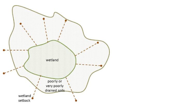
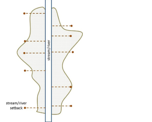
Special Use Permits
A special use permit may be granted by the Planning Board for the construction of roads and other access ways, pipelines, power lines and other transmission lines, provided that ALL of the following conditions are found to exist. Applications for a Special Use Permit must include the precise location of wetland boundaries
Design and construction methods will be such as to minimize detrimental impact upon the wetlands and will include restoration of the site as nearly as possible to its original grade and condition.
Economic advantage alone is not the reason for the proposed construction.
Before grant of a Special Use Permit under this section, the applicant shall agree to submit a performance security to the Board of Selectmen. The security shall be submitted in a form and amount, with surety and conditions satisfactory to the Selectmen and approved by Town Counsel to ensure that the construction has been carried out in accordance with the approved design. The security shall be submitted and approved prior to issuance of any permit authorizing construction.
The Planning Board may require the applicant to submit a wetlands impact assessment to aid in evaluation of the application. The wetland impact assessment shall be based on a functional evaluation of the resource, before and after proposed development of the site, using the reference The Method for Inventorying and Evaluating Freshwater Wetlands in New Hampshire (NH Method, 2013 as updated). The cost of the assessment shall be borne by the applicant. The Planning Board may also assess the applicant reasonable fees to cover the costs of other special instigative studies and for the review of documents required by particular applications.
Special Exceptions
Upon application to the Zoning Board of Adjustment, a special exception shall be granted to permit the erection of a structure within the Wetlands and Surface Water Overlay District on approved building lot provided that all of the following conditions are found to exist.
The lot upon which an exception is sought was an official lot of record, as recorded in the Rockingham County Registry to Deeds as of March 8, 1988.
Due to the provisions of the Wetlands and Surface Water Overlay District, no reasonable and economically viable use of the lot can be made without the exception.
The design and construction of the proposed use will, to the extent practicable, be constructed with the purpose and intent of this Section.
The proposed use will not create a hazard to individual or public health, safety and welfare due to the loss of wetland, the contamination of groundwater or other reason.
The Zoning Board of Adjustment may themselves, or upon petition from the Building Inspector, Conservation Commission or abutters, hire a qualified consultant or consultants to prepare such studies as are necessary to determine whether the conditions set forth above have been met. The cost of such studies shall be borne by the applicant.
Permit Review Procedures
Building permits for individual lots:
Lots of Record as of March 8, 1988 – The Building Inspector shall check the location of proposed construction relative to wetlands to ensure compliance with this Ordinance. A plan showing extent of wetlands, setbacks and vegetative buffers shall be submitted to and reviewed by the Building Inspector. The person applying for a building permit shall gather information necessary to demonstrate compliance with the requirements of this Ordinance. Additional information may be requested at the discretion of the Building Inspector.
Multi-family and Non-Residential Development Applications – The Building Inspector shall rely on the Planning Board for determination of compliance with this Ordinance as part of the review process for applications subject to the Subdivision and Site Plan Review Regulations.
Subdivision applications:
Upon receiving a subdivision application, the Planning Board shall review the location of all proposed new lots relative to wetlands to ensure compliance to this Ordinance.
Multi-family and Non-residential Site Plan Review applications:
Upon receiving a multi-family or non-residential site plan review application the Planning Board shall review the location of all proposed construction relative to wetlands to ensure compliance with this Ordinance.
Any wetland (including prime wetlands and vernal pools) or wetland setback or buffer altered in violation of this ordinance shall be restored at the expense of the violator(s) as provided by RSA 483-A:5 and under the direction of a New Hampshire Certified Wetland Scientist. Said restoration shall be subject to review by the Hampton Falls Conservation Commission. When appropriate, injunctive relief shall be sought by the Town as per RSA 676:15 and civil fines imposed as per RSA 676:17.
Appeal of Wetland Classification or Boundaries
In the event that the Wetlands and Surface Water Overlay District and or associated boundary is in dispute between an applicant and a Hampton Falls Local Land Use Board (as defined by NH RSA 672:7), the Local Land Use Board may call upon the services of an independent NH certified wetlands scientist to examine said area and report findings to the Local Land Use board for their determination of the wetland conservation district and or boundary. The costs to the Town of such dispute shall be borne by the applicant.
§ III.9Hampton Falls Floodplain Development Ordinance
Adopted March 1990; amended March 2021
Purpose
Certain areas of the Town of Hampton Falls, New Hampshire are subject to periodic flooding, causing serious damages to properties within these areas. Relief is available in the form of flood insurance as authorized by the National Flood Insurance Act of 1968. Therefore, the Town of Hampton Falls, New Hampshire has chosen to become a participating community in the National Flood Insurance Program and agrees to comply with the requirements of the National Flood Insurance Act of 1968 (P.L. 90-488, as amended) as detailed in the Floodplain Development Ordinance.
General
This ordinance, adopted pursuant to the authority of RSA 674:16, shall be known as the Town of Hampton Falls Floodplain Development Ordinance. The regulations in this ordinance shall overlay and supplement the regulations in the Town of Hampton Falls Zoning Ordinance and shall be considered part of the Zoning Ordinance for purposes of administration and appeals under state law. If any provision of this ordinance differs or appears to conflict with any provision of the Zoning Ordinance or other ordinance or regulation, the provision imposing the greater restriction or more stringent standard shall be controlling.
The following regulations in this ordinance shall apply to all lands designated as special flood hazard areas by the Federal Emergency Management Agency (FEMA) in its “Flood Insurance Study for Rockingham County, N.H., dated May 17, 2005 and January 29, 2021, as amended, together with the associated Flood Insurance Rate Maps dated May 17, 2005 and January 29, 2021, as amended, which are declared to be a part of this ordinance and are hereby incorporated by reference.
Amended March 2021
Definition of Terms for Floodplain Development Ordinance
The following definitions shall apply only to this Floodplain Development Ordinance and shall not be affected by, the provisions of any other ordinance of the Town of Hampton Falls.
9.3.1 “Area of Special Flood Hazard” is the land in the floodplain within the Town of Hampton Falls subject to a one-percent or greater possibility of flooding in any given year. The area is designated on the Flood Insurance Rate Map as Zone A and Zone AE.
Amended March 2021
9.3.2 “Base Flood” means the flood having a one-percent possibility of being equaled or exceeded in any given year.
9.3.3 “Base Flood Elevation” means the water surface elevation having a one-percent chance of being equaled or exceeded in any given year.
9.3.4 ‘Basement” means any area of a building having its floor subgrade on all sides.
9.3.5 ”Building” – see “Structure”.
9.3.6 “Development” means any man-made change to improved or unimproved real estate, including but not limited to buildings or other structures, mining, dredging, filling, grading, paving, excavation, drilling operation or storage of equipment or materials.
9.3.7 “FEMA” means the Federal Emergency Management Agency
9.3.8 “Flood” or “Flooding” means a general and temporary condition of partial or complete inundation of normally dry land areas from (1) the overflow of inland or tidal water or (2) the unusual and rapid accumulation of runoff of surface water from any source.
9.3.9 “Flood Insurance Study” means an examination, evaluation and determination of flood hazards and if appropriate, corresponding water surface elevations or an examination and determination of mudslide or flood-related erosion hazards.
9.3.10 “Flood Insurance Rate Map” (FIRM) means an official map incorporated with this ordinance, on which FEMA has delineated both the special flood hazard areas and the risk premium zones applicable to the Town of Hampton Falls.
9.3.11 “Floodplain” or “Flood-Prone Area” means any land area susceptible to being inundated by water from any source (see definition of “Flooding”).
9.3.12 “Flood Proofing” means any combination of structural and non-structural additions, changes or adjustments to structures which reduce or eliminate flood damage to real estate or improved real property, water and sanitation facilities, structures and their contents.
9.3.13 “Floodway” – see “Regulatory Floodway”.
9.3.14 “Functionally Dependent Use” means a use which cannot perform its intended purpose unless it is located or carried out in close proximity to water. The term includes only docking and port facilities that are necessary for the loading/unloading of cargo or passengers and ship building/repair facilities but does not include long-term storage or related manufacturing facilities.
9.3.15 “Highest Adjacent Grade” means the highest natural elevation of the ground surface prior to construction next to the proposed walls of a structure.
9.3.16 “Historic Structure” means any structure that is:
9.3.16.1 Listed individually in the National Register of Historic Places (a listing maintained by the Department of Interior) or preliminarily determined by the Secretary of the Interior as meeting the requirements for individual listing on the National Register;
9.3.16.2 Certified or preliminarily determined by the Secretary of the Interior as contributing to the historical significance of a registered historic district or a district preliminarily determined by the Secretary to qualify as a registered historic district;
9.3.16.3 Individually listed on a state inventory of historic places in states with historic preservation programs which have been approved by the Secretary of the Interior; or
9.3.16.4 Individually listed on a local inventory of historic places in communities with historic preservation programs that have been certified either (1) by an approved state program as determined by the Secretary of the Interior, or (2) directly by the Secretary of the Interior in states without approved programs.
9.3.17 “Lowest Floor” means the lowest floor of the lowest enclosed area (including basement). An unfinished or flood resistant enclosure, usable solely for parking of vehicles, building storage in an area other than a basement area is not considered a building’s lowest floor; provided, that such an enclosure is not built so as to render the structure in violation of the applicable non-elevation design requirements of this ordinance.
9.3.18 “Manufactured Home” means a structure, transportable in one or more sections, which is built on a permanent chassis and is designed for use with or without a permanent foundation when connected to the required utilities. For Floodplain management purposes the term “manufactured home” includes park trailers, travel trailers and other similar vehicles placed on site for greater than one hundred eighty (180) consecutive days.
9.3.19 “Mean Sea Level” means the National Geodetic Vertical Datum (NGVD) of 1929, North American Vertical Datum (NAVD) of 1988 or other datum to which base flood elevations shown on a community’s Flood Insurance Rate Map are referenced.
9.3.20 “New Construction” means, for purposes of determining insurance rates, structures for which the “start of construction” commenced on or after the effective date of an initial FIRM or after December 31, 1974, whichever is later and includes any subsequent improvement to such structures. For floodplain management purposes, new construction means structures for which the start of construction commenced on or after the effective date of a floodplain management regulation adopted by a community and includes any subsequent improvements to such structures.
9.3.21 “Recreational Vehicle” means a vehicle which is:
9.3.21.1 built on a single chassis;
9.3.21.2 four hundred square feet or less when measured at the largest horizontal projection;
9.3.21.3 designed to be self-propelled or permanently towable by a light duty truck; and
9.3.21.4 designed primarily not for use as a permanent dwelling but as temporary living quarters for recreational, camping, travel or seasonal use.
Adopted March 1994
9.3.22 “Regulatory Floodway.”” means the channel of a river or other watercourse and the adjacent land areas that must be reserved in order to discharge the base flood without increasing the water surface elevation more than a designated height.
9.3.23 “Special Flood Hazard Area” see - “Area of Special Flood Hazard”.
9.3.24 “Structure” means for floodplain management purposes, a walled and roofed building, including a gas or liquid storage tank that is principally above ground, as well as a manufactured home.
9.3.25 “Start of Construction” includes substantial improvements and means the date of the building permit was issued, provided the actual start of construction, repair, reconstruction, placement or other improvement was within one hundred eighty (180) days of the permit date. The actual start means either the first placement of permanent construction of a structure on site, such as the pouring of slab or footings, the installation of piles, the construction of columns or any work beyond the stage of excavation; or the placement of manufactured home on a foundation.
Permanent construction does not include land preparation, such as clearing, grading and filing; not does it include the installation of streets and/or walkways; nor does it include excavation for a basement, footings, piers or foundations or the erection of temporary forms; nor does it include the installation on the property of accessory buildings, such as garages or sheds not occupied as dwelling units or part of the main structure.
9.3.26 “Substantial Damage” means damage of any origin sustained by a structure whereby the cost of restoring the structure to its before damaged condition would equal to exceed fifty percent (50%) of the market value of the structure before the damage occurred.
9.3.27 “Substantial Improvement” means any combination of repairs, reconstruction, alteration or improvements to a structure in which the cumulative cost equals or exceeds fifty percent (50%) of the market value of the structure. The market value of the structure should equal: (1) the appraised value prior to the start of the initial repair or improvement or (2) in the case of damage, the value of the structure prior to the damage occurring. For the purposes of this definition, “substantial improvement” is considered to occur when the first alteration of any wall, ceiling, floor or other structural part of the building commences, whether or not that alteration affects the external dimensions of the structure. This term includes structures which have incurred substantial damage, regardless of actual repair work performed. The term does not; however, include any project for improvement of a structure required to comply with existing health, sanitary or safety code specifications which are solely necessary to assure safe living conditions or any alteration of an “historic structure” provided that the alteration will not preclude the structure’s continued designation as an “historic structure”.
9.3.28 “Violation” means the failure of a structure or other development to be fully compliant with the community’s floodplain management regulations. A structure or other development without the elevation certificate, other certifications or other evidence of compliance required by this ordinance is presumed to be in violation until such time as that documentation is provided.
9.3.29 “Water Surface Elevation” means the height, in relation to the National Geodetic Vertical Datum (NGVD) of 1929, North American Vertical Datum (NGVD) of 1988 (or other datum, where specified) of floods of various magnitudes and frequencies in the floodplains.
Permit for Floodplain Development
All proposed development in any special flood hazard areas shall require a permit.
The building inspector shall review all building permit applications for new construction or substantial improvements to determine whether proposed building sites will be reasonably safe from flooding. If a proposed building site is located in a special flood hazard area, all new construction or substantial improvements shall:
be designed (or modified) and adequately anchored to prevent flotation, collapse or lateral movement of the structure resulting from hydrodynamic and hydrostatic loads, including the effects of buoyancy,
be constructed with materials resistant to flood damages,
be constructed by methods and practices that minimize flood damages,
be constructed with electrical, heating, ventilation, plumbing and air conditioning equipment, and other service facilities that are designed and/or located so as to prevent water from entering or accumulating within the components during conditions of flooding.
Water and Sewer in Floodplain Areas
Where new or replacement water and sewer systems (including on-site systems) are proposed in a special flood hazard area the applicant shall provide the Building Inspector with assurance that these systems will be designed to minimize or eliminate infiltration of flood waters into the systems and discharges from the systems into flood waters and on-site waste disposal systems will be located to avoid impairment to them or contamination from them during periods of flooding.
Structures in Floodplain Areas
For all new or substantially improved structures located in Zones A and AE, the applicant shall furnish the following information to the building inspector:
the as-built elevation (in relation to mean sea level) of the lowest floor (including basement) and include whether or not such structures contain a basement.
if the structure has been floodproofed, the as-built elevation (in relation to mean sea level) to which the structure was floodproofed.
any certification of flooding.
The Building Inspector shall maintain for public inspection and shall furnish such information upon request.
Federal and State Permits for Floodplain Development
The Building Inspector shall not grant a building permit until the applicant certifies that all necessary permits have been received from those governmental agencies from which approval is required by federal or state law, including Section 404 of the Federal Water Pollution Control Act Amendments of 1972, 33 U.S.C. 1334.
Watercourses
In riverine situations, prior to the alteration or relocation of a watercourse the applicant for such authorization shall notify the New Hampshire Department of Environmental Services Wetlands Bureau and submit copies of such notification to the Building Inspector, in addition to the copies required by RSA 482-A:3. Further, the applicant shall be required to submit copies of said notification to those adjacent communities as determined by the Building Inspector including notice of all scheduled hearings before the Wetlands Bureau.
The applicant shall submit to the Building Inspector, certification provided by a registered professional engineer, assuring that the flood carrying capacity of an altered or relocated watercourse can and will be maintained.
Along watercourses that have not had a Regulatory Floodways designated, no new construction, substantial improvements or other development (including fill) shall be permitted within Zone AE on the Flood Insurance Rate Map unless it is demonstrated by the applicant that the cumulative effect of the proposed development, when combined with all existing and anticipated development will not increase the water surface elevation of the base flood more than one foot (1’) at any point within the community.
The Building Inspector shall obtain, review and reasonably utilize any floodway data available from federal, state or other sources as criteria for requiring that all development located in Zone A meet the following floodway requirement;
No encroachments, including fill, new construction, substantial improvements and other development are allowed within the floodway that would result in any increase in flood levels within the community during the base flood discharge.
Amended March 2021
In special flood hazard areas the Building Inspector shall determine the base flood elevation in the following order of precedence according to the data available:
In Zone AE refer to the elevation data provided in the community’s Flood Insurance Study and accompanying Flood Insurance Rate Map.
In Zone A, the Building Inspector shall obtain, review and reasonably utilize any base flood elevation data available from any federal, state or other source including data submitted for development proposals submitted to the community (i.e., subdivisions, site approvals).
In Zone A when a base flood elevation is not available, the base flood elevation shall be at least two feet above the highest adjacent grade.
The Building Inspector’s base flood elevation determination will be used as criteria for requiring in Zones AE and A that:
All new construction or substantial improvement of residential structures have the lowest floor (including basement) elevated to or above the base flood elevation.
That all new construction or substantial improvements of non-residential structures have the lowest floor (including basement) elevated to or above the base flood elevation; or together with attendant utility and sanitary facilities shall:
be floodproofed so that below the base flood elevation the structure is watertight with walls substantially impermeable to the passage of water;
have structural components capable of resisting hydrostatic and hydrodynamic loads and the effects of buoyancy; and
be certified by a registered professional engineer or architect that the design and methods of construction are in accordance with accepted standards of practice for meeting the provisions of this section.
All manufactured homes to be placed or substantially improved within special flood hazard areas shall be elevated on a permanent foundation such that the lowest floor of the manufactured home is at or above the base flood elevation; and be securely anchored to resist flotation, collapse, or lateral movement. Methods of anchoring may include, but are not limited to, use of over-the-top or frame ties to ground anchors. This requirement is in addition to applicable state and local anchoring requirements for resisting wind forces.
Recreational vehicles placed on sites within Zones A and AE shall either:
be on the site for fewer than one hundred eighty (180) consecutive days,
be licensed and ready for highway use, or
meet all standards of Section 9.4 of this ordinance and the elevation and anchoring requirements for “manufactured homes” in 9.10.2.3 above.
For all new construction and substantial improvements, fully enclosed areas below the lowest floor that are subject to flooding are permitted provided they meet the following requirements:
the enclosed area is unfinished or flood resistant, usable solely for the parking of vehicles, building access or storage;
the area is not a basement; and
shall be designed to automatically equalize hydrostatic flood forces on exterior walls by allowing for the entry and exit of flood water. Designs for meeting this requirement must either be certified by a registered professional engineer or architect or must meet or exceed the following minimum criteria: A minimum of two (2) openings having a total net area of not less than one (1) square inch for every square foot of enclosed area subject to flooding shall be provided. The bottom of all openings shall be no higher than one foot (1’) above grade. Openings may be equipped with screens, louvers or other coverings or devices provided that they permit the automatic entry and exit of flood water.
Amended March 2021
Variances and Appeals for Floodplain Development
Any order, requirement, decision or determination of the building inspector made under this ordinance may be appealed to the Zoning Board of Adjustment as set forth in RSA 676:5.
If the applicant, upon appeal, requests a variance as authorized by RSA 674:33, I(b), the applicant shall have the burden of showing in addition to the usual variance standards under state law:
that if the requested variance is for activity within a designated regulatory floodway, no increase in flood levels during the base flood discharge will result;
that the variance is the minimum necessary, considering the flood hazard, to afford relief.
The Zoning Board of Adjustment shall notify the applicant in writing that:
the issuance of a variance to construct below the base flood level will result in increased premium rates for flood insurance up to amounts as high as twenty-five dollars ($25) for one hundred dollars ($100) of insurance coverage; and
such construction below the base flood level increases risk to life and property. Such notification shall be maintained with a record of all variance actions.
The community shall:
maintain a record of all variance actions, including their justification for their issuance, and
report such variances issued in its annual or biennial report submitted to FEMA’s Federal Insurance Administrator.
§ III.10Telecommunications Facility Ordinance
Adopted March 1997
Purpose
The general purpose is to preserve the authority of the Town to regulate and provide for reasonable opportunity for the siting of telecommunication facilities not to exceed one hundred feet (100’) in height.
Telecommunication Facilities
Any telecommunication facilities shall be located within the District. The Zoning Board of Adjustment may grant a Special Exception for Amateur Radio; Receive-only Antennas or Antennas located on property owned, leased or controlled by the Town and only after a license has been granted by the Board of Selectmen.
Site Regulations for Telecommunication Facilities
The Planning Board shall adopt site regulations which shall include but not be limited to: aesthetics and lighting; construction, building and safety standards; security and space requirements; landscaping and financial security for maintenance and/or removal of any facilities.
Additional Requirements for Telecommunication Facilities
Setbacks and Separation
Tower, guys, and accessory facilities must satisfy the minimum zoning district setback requirements.
§ III.11Elderly and Multi-Family Housing District
Adopted March 2004; amended March 2009, 2014
Purpose
The purpose of this article is to make provision for the development of Elderly, Multi-Family Housing, and Workforce Multi-Family Housing (owner and renter occupied) which will promote public health, safety and welfare, ensure a continued availability of diverse supply of home ownership and rental opportunities for low to moderate income households, preserve the rural character of the Town, encourage the appropriate and wise use of land, and otherwise contribute to the Town’s ability, through its zoning ordinance, to more fully meet the aims and purposes of zoning as set forth in NH RSA 674:58-61. The design of this section is to implement Multi-Family, Workforce Multi-Family, and Elderly housing within the Town of Hampton Falls providing for reasonable access to commercial services, transportation and potential future water and sewer service.
Definitions
11.2.1 “Affordable” Affordable means housing with combined rental and utility costs or combined mortgage loan debt services, property taxes, and required insurance that do not exceed thirty percent (30%) of a household’s gross annual income.
11.2.2 “Multi-Family Housing” is the inclusion of three or more dwelling units in one building on any one Lot of Record. Multi-Family Housing, where permitted, may include multiple buildings containing three or more dwelling units on any one Lot of Record. Multi-Family housing for the purpose of workforce housing, means a building or structure containing five (5) or more dwelling units, each designed for occupancy by an individual household.
11.2.3 “Reasonable and realistic opportunities for the development of workforce housing” opportunities to develop economically viable workforce housing within the framework of a municipality’s ordinances and regulations adopted pursuant to NH RSA 674 [Local Land Use Planning and Regulatory Powers] and consistent with NH RSA 672:1, III-e.
11.2.4 “Workforce Housing/owner occupied” housing which is intended for sale and which is affordable to a household with an income of no more than one hundred percent (100%) of the median income for a four (4) person household for the metropolitan area or county in which the housing is located as published annually by the United States Department of Housing and Urban Development.
11.2.5 “Workforce Housing/renter occupied” rental housing which is affordable to a household with an income of no more than sixty percent (60%) of the median income for a three (3) person household for the metropolitan area or county in which the housing is located as published annually by the United States Department of Housing and Urban Development. Housing Developments that exclude minor children from more than twenty percent (20%) of the units, or in which more than fifty percent (50%) of the dwelling units have fewer than two (2) bedrooms, shall not constitute workforce housing for the purpose of this Article.
11.2.6 “Area Median Income (AMI)” the median income of the greater region, either the HUD Metropolitan or Non-Metropolitan Fair Market Area to which the community belongs, as is established and updated annually by the United States Department of Housing and Urban Development. Income considers both wage income and assets.
11.2.7 “Elderly, Multi-Family and Multi-Family Workforce Dwelling Unit or Unit” is the assemblage of connected living areas within a structure to provide for the residence, cooking, sanitation facilities, and accessory areas sufficient for up to, but not more than, one (1) single-family. Dwelling units shall be physically distinct from one another within any structure or on any lot. Any determination made under this article as to the necessary size or capacity of septic systems or wells shall treat each dwelling unit as a single-family home with the number of bedrooms contained within such unit to be determined in accordance with public health and building code regulations existing as of the time of submittal of an application under this article.
Amended March 2023
11.2.8 “Frontage” is the measurement of the boundary of a Lot of Record directly abutting a Class V or higher Town road or state highway.
Amended March 2020
11.2.9 “Elderly Housing” shall mean housing which complies with 42 U.S.C. §3607(b) and applicable provisions of N.H. RSA 354-A:15 (Housing for Older Persons); however, all permanent resident or occupants shall be at least fifty-five (55) years of age. “Occupant” shall mean any person who stays overnight in a Unit for more than twenty-one (21) days in any sixty (60) day period or for more than thirty (30) days in any twelve (12) month period. All Elderly Housing developments shall incorporate a written enforcement mechanism satisfactory to the Planning Board and its legal counsel whereby on an annual basis, a written age-based census of the existing Occupants shall be provided to the Planning Board. Upon any change in ownership or tenancy, the age of any new occupants shall be given to the Planning Board within thirty (30) days of tenancy/ownership change.
Boundaries of the Elderly and Multi-Family Housing Districts Overlay Map
Elderly and Multi-Family Housing Districts shall be as depicted on the Elderly and Multi-Family Housing District Overlay Map designated as the “Town of Hampton Falls Elderly and Multi-Family Housing Districts Overlay Map,” which is part of the official Zoning Map of the Town of Hampton Falls.
Amended March 2014
General Requirements Applicable to Elderly and Multi-Family Housing Developments
Developments in the Multi-Family Overlay District shall be limited to development on a parcel of no less than eight (8) acres with no less than two hundred fifty feet (250’) of frontage. Developments in the Elderly/Multi-Family Overlay District shall have no less than eight (8) acres and two hundred fifty feet (250’) of frontage. No single Elderly, Multi-Family, or Affordable/Workforce Multi-Family project shall contain a number of dwelling units greater than five percent (5%) of the existing number of housing units in the Town.
Amended March 2023
For both the Elderly/Multi-Family District and the Multi-Family District, minimum building setbacks from the front, side and rear lot lines, shall be one hundred feet (100’). Minimum separation between buildings on the site, shall be fifty feet (50’. Structures and improvements within the TCD, BDS and BDN Districts shall be subject to the setback requirements of the TCD, BDS and BDN Districts. The required setback areas shall serve as a vegetative buffer to provide an adequate transition from abutting land uses and existing Town roads. Landscaping of the buffer is required, and wherever possible natural vegetation shall be retained.
Adopted March 2014
The Planning Board may, for proper cause, issue special use permits in order to relax lot line set back and building separation requirements by up to fifty percent (50%) provided the board can find:
That adequate natural buffering from the lot line setback(s) is in place at the commencement of the project; and
That such special use permit will promote other aspects of the project that are consistent with the rural character of the area (e.g., such as promoting conservation of open space or preservation of important site natural or visual features); and
That the granting of such special use permit will not materially impair the character of the area or the value of abutting properties; and
That the granting of the special use permit will not impair fire or public safety response considerations.
The Planning Board may require increased shielding vegetative buffers within the setbacks where it finds the project will adversely impact an abutting property owner to a greater extent than would be the case for a single-family home in the same location.
The maximum allowable density permitted on a site is eight (8) bedrooms per acre of upland, and shall be calculated as follows:
Subtract all very poorly and poorly drained soils from the total parcel acreage.
Add fifty percent (50%) of any upland areas that are not contiguous to the largest contiguous upland area on the parcel.
Multiply the resultant acreage by eight (8) bedrooms to get the maximum number of bedrooms allowed on the site.
Example: A site has eighteen (18) acres of which ten (10) acres are very poorly and poorly drained soils. Subtracting the very poorly and poorly drained soils (10 acres) from the total parcel (18 acres) results in eight (8) acres of uplands. Of these upland areas, the largest contiguous upland is six (6) acres, which leaves a balance of two (2) acres of non-contiguous upland. Adding fifty percent (50%) of the two (2) acre (non-contiguous upland) balance, (or one (1) acre) to the six (6) acre (contiguous upland) parcel results in seven (7) acres that can be used to calculate the number of allowable bedrooms: 7 acres x 8 bedrooms per acre = 56 bedrooms.
Septic Requirements – See Article XI, Section 3.
Amended March 2025
Applications for Multi-Family, Elderly Housing, or Affordable/Workforce Multi-family Housing (per NH RSA 674:58-61) developments shall be submitted to the Planning Board. The Planning Board may require architectural drawings and material schedules indicating exterior finish materials and colors for buildings within the project which will permit the Board to render comments and suggestions to promote consistency with the character of the surrounding area, in addition to other studies and/or reports as may be required under the Town of Hampton Falls Site Plan Review Regulations.
The Planning Board may waive a specific Site Plan Regulation where the strict enforcement thereof would impose a significant impediment, financial or otherwise, upon the project and the waiver would promote the purposes of this Article and preservation of the character of the surrounding area.
Additional Requirements for Elderly and Multi-Family Housing Developments
Elderly Housing and Multi-Family Developments shall provide for at least one (1) paved parking space for each Dwelling Unit within the project. All parking must be provided on site and may include garage and driveway areas to individual units.
Amended March 2026
All Elderly Housing and Multi-Family Developments shall make provision for pedestrian access within the development and, to the extent feasible, to off-site community facilities and services.
An Elderly Housing building shall have a maximum of twenty-four (24) bedrooms. Elderly Housing shall be designed and constructed in accordance with the State of New Hampshire Architectural Barrier Free Design Code, as amended.
A Multi-Family or affordable/workforce Multi-Family building shall have a maximum of twenty-four (24) bedrooms.
Amended March 2023
The maximum per building footprint for Elderly/Multi-Family and affordable/workforce Multi-Family Housing shall be ten thousand (10,000) sq. ft. (not including enclosed parking or garages).
All roadways within any Elderly or Multi-Family or affordable/workforce Multi-Family housing development shall be built to Town standards according to Planning Board regulations and shall be owned and maintained by the developer/property owner, Dwelling Unit owners and/or any Unit Owners’ Association provided for in the development project. The Planning Board may, for proper cause, grant waivers of width and/or other road standards where such waivers are consistent with the overall design and anticipated use of the project and are consistent with the character of the area in which the project is located. Ingress to and egress from any such Elderly/Multi-Family or Multi-Family housing development shall be located on the frontage roadway.
For developments which involve condominium ownership, it shall be the responsibility of the developer/builder of each such housing development to establish a Home Owner’s Association and to prepare and adopt appropriate Articles and By-Laws which are to be submitted in advance to the Planning Board and Town Counsel (at developer’s expense) for their review and approval.
Affordability for the purpose of Affordable/Workforce Multi-Family Developments
Certification of Income Levels. For the purpose of Affordable/Workforce Multi-Family developments in order to ensure that only eligible households purchase/rent the designated affordable housing units, the purchaser/renter of an affordable unit must submit copies of their last three (3) years federal income tax returns and written certification, verifying that their annual income level, combined with household assets, does not exceed the maximum level as established by this ordinance. The tax returns and written certification of income and assets must be submitted to the developer of the housing units, or the developer’s agent, prior to the transfer of title. A copy of the tax return and written certification of income and assets must be submitted to all parties charged with administering and monitoring this ordinance, within thirty (30) days following the transfer of title.
Assurance of continued affordability. Affordable units offered for sale and approved by the Planning Board as part of a subdivision or site plan and subject to NH RSA 674:58-61 shall require a restrictive covenant and lien granted to the Town of Hampton Falls. The initial value of the lien shall be equal to the difference between the fair market value of the unit and its reduced affordable sale price, which is indexed according to the qualifying income standards. The Town of Hampton Falls’ lien is indexed over time at a rate equal to the consumer price index identified in the restrictive covenant and lien document. Future maximum resale limits shall be calculated as the fair market value minus the adjusted lien value and a transaction administrative fee. Subsequent sales prices are not limited based on income targets, but on the combination of the housing unit’s fair market value, minus the adjusted lien value and adherence to the definition of affordable owner-occupied housing contained in this Article. The restrictive covenant and lien shall be in a form approved by the Planning Board.
Affordable housing rental units shall limit annual rent increases to the percentage increase in the area median income, except to the extent that further increases are made necessary by hardship or other unusual conditions.
Documentation of restrictions. Deed restrictions, restrictive covenants, or contractual arrangements related to dwelling units established under this Article must be set forth on all plats filed with the Town’s Planning Board and with the Registry of Deeds.
Administration, Compliance and Monitoring for the purpose of Affordable/Workforce Multi-Family
This Article shall be administered by the Planning Board in the context of Site Plan review. Any person who applied for approval of a development that is intended to qualify as workforce housing shall file a written statement of such intent as part of the application and shall be subject to the provisions of NH RSA 674:58-61.
Certificate of Occupancy. No certificate of Occupancy shall be issued for an affordable housing unit without written confirmation of the income eligibility of the tenant or buyer of the affordable housing unit and confirmation of the rent or price of the affordable housing unit as documented by an executed lease or purchase and sale agreement.
Ongoing responsibility for monitoring the compliance with resale and rental restrictions on affordable units shall be the responsibility of a monitoring agency of the Planning Board’s choice including, but not limited to, the New Hampshire Housing Finance Authority. If the Planning Board’s choice for monitoring and compliance is the New Hampshire Housing Finance Authority, then the owner of said affordable units shall follow the requirements as set forth in the New Hampshire Housing Finance Authority’s Model for Homeownership Affordability Retention Lien as amended.
Annual report. The owner of a project containing affordable units for rent shall prepare an annual report certifying that the gross rents of affordable units have been maintained in accordance with this Article. Such reports shall be submitted to the monitoring agent or their designee and shall list the contract rent and occupant household incomes of all affordable housing units for the calendar year.
Elderly Housing and Affordable/Workforce Multi-Family units are exempt from school impact fees.
§ III.12Home Occupation
Adopted March 2004; amended March 2011
Purpose
The Town of Hampton Falls recognizes the need for some residents to use their residential property for limited business use. However, the Town believes that it is important to protect the integrity of the Agricultural/Residential Zoning District. Therefore, the purpose of this section is to regulate the conduct of home occupations so that they will not adversely affect the appearance, character or condition of the residence or neighborhood.
Definition
A Home Occupation is a limited business use of a residential property which is conducted entirely on the property, operated solely by the resident, which is incidental, and subordinate to the residential use and does not change the essential residential character of the property. Examples of “home occupations” include but are not limited to: seamstress, lawyer, tutor, musician, photographer, antique dealer, architect, potter, engineer, swimming or tennis instructor.
Classes of Home Occupations
There shall be two (2) classes of home occupations identified as Level I and Level II.
Level I Home Occupations do not require a permit from the Planning Board, as long as the following provisions are met:
There shall be no non-resident employees, and
The use shall generate no additional vehicular traffic, and
The home occupation shall not advertise with a sign on the premises.
Level II Home Occupations
All other home occupations shall be defined as Level II and require a Home Occupation Application/Permit. Application shall require a public hearing before the Planning Board with proper notice in accordance with RSA 676:4, I(d). This application/permit must be submitted (for each proposed home occupation) to the Building Inspector who will review the application to determine if the standards below have been met. If met, the Building Inspector will recommend the Planning Board approved the application. If not met, the Planning Board will review the application and the Building Inspector’s findings and determine whether the application should be approved, approved with amendments or denied. The Home Occupation Application/permit requires the Planning Board’s final approval before the home occupation can commence operation.
Standards
A home occupation shall be conditionally permitted if it meets the following standards:
Number of Home Occupations. There shall be no more than two home occupations per residence. A separate application shall be made for each occupation. Two (2) occupants shall be considered as one (1) for the purposes of meeting the remaining standards below.
Floor Area. Business use of the premises shall be restricted to one-quarter (1/4) of the total area of the principal and any accessory buildings, but in no case shall the total area utilized for the home occupation(s) exceed six hundred (600) square feet. In the case of an outdoor recreational cottage industry (i.e., sports training, swimming or tennis lessons) the total square footage of the playing surface shall not be greater than a mutually agreed upon professional standard for the proposed use. All other zoning standards (i.e., dimensional and lot size requirements) shall apply.
Employment. Any and all home occupations shall be operated by the person(s) living in the principal residence unit full time. Not more than three (3) employees are permitted, including the resident operator(s)/employee(s).
Hours of Operation. Hours of operation shall be limited to 8AM to 5 PM Monday through Friday. Weekend hours shall be subject to Planning Board approval.
Parking. Parking to support the home occupation must be maintained on-site. No more than three (3) vehicles shall be parked simultaneously on the premises at any time for business purposes. Parking of commercial vehicles in District “A” is controlled by Article XI, Section 3.3.6.
Traffic. Traffic generated by the home occupation shall not increase the volume of traffic so as to create a traffic hazard, traffic nuisance or disturbance or interfere with the residential character of the neighborhood; traffic generated by the business shall not involve the use of heavy commercial vehicles. Heavy commercial vehicles are defined as having more than six (6) wheels or more than two (2) axles. Outgoing shipments are restricted to one (1) per day.
Nuisance Control. The home occupation shall not create objectionable conditions including, but not limited to, the following nuisances detectable by ordinary senses off the premises; noise, vibration, glare, heat, dust/airborne particles, odor/fumes, smoke or electrical interference.
Hazardous Material/Waste. The home occupation shall not use, store or generate hazardous material or waste beyond the type and quantity of normal household use.
Exterior Lighting. Exterior lighting for such business use shall be minimized and shall be directed and fully shielded from neighboring properties, public ways and the night sky.
Signage. Signs for the home occupations shall be in accordance with the Hampton Falls Sign Ordinance, Article IV of the Zoning Ordinance. Signs are further limited as follows: No sign shall exceed six (6) square feet and no lighting of the sign is permitted.
Amended March 2012
Outdoor Storage. No materials, finished product or equipment associated with the home occupation shall be stored outside the buildings.
Operations. All home occupations shall be conducted entirely within enclosed buildings except those that are recreational in nature (i.e., tennis, swimming or other similar recreational home occupations where lessons are provided).
Septic Usage. Septic system capacity shall meet Town and State requirements for the residential and proposed use of the premise.
Licenses and Professional Registrations. Any license and/or professional registrations required by local, state or federal authorities and/or professional organizations shall be obtained and maintained current as long as the business remains viable. Copies of these documents shall be provided to the Town for file and maintained current.
Subordinate Use. The business use shall be clearly incidental and secondary to the use of the premises for residential purposes.
§ III.13Aquifer Protection District
Adopted March 2007
Authority and Purpose
Pursuant to RSA 674:16-21, the Town of Hampton Falls adopts an Aquifer Protection District and accompanying regulations in order to protect, preserve and maintain potential groundwater supplies and related groundwater recharge areas within known aquifers identified by the Town. The objectives of the aquifer protection district are:
to protect the public health and general welfare of the citizens of the Town of Hampton Falls;
to prevent development and land use practices that would contaminate or reduce the recharge of the identified aquifer;
to promote future growth and development of the Town, in accordance with the Master Plan, by insuring the future availability of public and private water supplies; and
to encourage uses that can appropriately and safely be located in the aquifer recharge areas.
Administration
General: The provision of the Aquifer Protection District shall be administered by the Planning Board. All development proposals within this district, other than single-family residential construction not involving the subdivision of land, shall be subject to subdivision and/or site plan review and approval in accordance with Planning Board rules and regulations. Such review and approval shall precede the issuance of any building permit by the Town.
Enforcement: The Board of Selectmen shall be responsible for the enforcement of the provisions and conditions of the Aquifer Protection District.
Definitions
13.3.1 “Animal Feedlot” A commercial agricultural establishment consisting of confined feeding areas and related structures used for the raising of livestock. An animal feedlot shall be considered one on which more than five (5) animals are raised simultaneously.
13.3.2 “Aquifer” For the purpose of this Ordinance, aquifer means a geologic formation, group of formations, or part of a formation that is capable of yielding usable quantities of groundwater.
13.3.3 “Dwelling Unit” A building or that portion of a building consisting of one or more designed for living and sleeping purposes, including kitchen and sanitary facilities and intended for occupancy by not more than one family or household.
13.3.4 “Groundwater” All the water below the land surface in the zone of saturation or in rock fractures capable of yielding water to a well.
13.3.5 “Groundwater Recharge” The infiltration of precipitation through surface soil materials into groundwater. Recharge may also occur from surface waters, including lakes, streams and wetlands.
13.3.6 “Leachable Wastes” Waste materials, including solid wastes, sludge and agricultural wastes that are capable of releasing contaminants to the surrounding environment.
13.3.7 “Mining of Land” The removal of geologic materials such as topsoil, sand and gravel, metallic ores, or bedrock to be crushed or used as building stone.
13.3.8 “Non-Conforming Use” see Article III, Section 6.1 and Article III, Section 13.3.8 is hereby defined as any structure, lot, or use of land that lawfully existed prior to the enactment of this (or the applicable) ordinance, and no longer conforms with current regulations of the district in which it is situated.
Adopted March 2023
13.3.9 “Non-Municipal Well” Any well not owned and operated by the Town of Hampton Falls or its agent.
13.3.10 “Recharge Area” The area from which groundwater recharge occurs.
13.3.11 “Septage” Liquid or solid waste generated by septic disposal systems. Septic waste containing wash water, gray waters, human feces, excrement, dregs, sediment, grease, oils and any other waste generated in a domestic septic disposal system.
13.3.12 “Sludge” Residual materials produced by the sewage treatment process.
13.3.13 “Solid Waste” Any discarded or abandoned material including, without limitation, refuse, putrescible material, septage, or sludge or other solid waste, as defined by New Hampshire Code of Administrative Rules Env-Wm 101-300 & 2100 Solid Waste Rules. Solid waste includes solid, liquid, semi-solid, or contain gaseous waste materials resulting from residential, industrial, commercial, mining, and agricultural operations and from community activities.
13.3.14 “Structure” Anything constructed or erected, except a boundary wall or fence, the use of which requires location on the ground or attachment to something on the ground. For the purposes of this Ordinance, buildings are structures.
13.3.15 “Toxic or Hazardous Materials” Any substance or mixture of such physical, chemical, or infectious characteristics as to pose a significant, actual or potential hazard to water supplies, or other hazard to human health, if such substances or mixture were discharged to land or waters of this Town. Toxic or hazardous materials include, without limitation, volatile organic compounds, petroleum products, heavy metals, radioactive or infectious wastes, acids and alkalies and include products such as pesticides, herbicides, solvents and thinners, and such other substances as defined in New Hampshire Code of Administrative Rules Env-Wm 1403, 1304.5 Groundwater Management and Groundwater Release Detection Permits. Wastes generated by the following commercial activities are presumed to be toxic or hazardous, unless and except to the extent that anyone engaging in such an activity can demonstrate the contrary to the satisfaction of the Planning Board:
Airplane, boat and motor vehicle service and repair;
Chemical and bacteriological laboratory operation;
Dry cleaning;
Electronic circuit manufacturing;
Metal plating, finishing and polishing;
Motor and machinery service and assembly;
Painting, wood preserving and furniture stripping;
Pesticide and herbicide application;
Photographic processing; and
Printing.
District Boundaries
Location
The Aquifer Protection District is defined as the area shown on the map prepared by the Rockingham Planning Commission entitled, “Stratified Drift Aquifers Map, Hampton Falls, NH, dated June 2003” or as amended.
The Aquifer Protection District is a zoning overlay district which imposes additional requirements and restrictions to those of the current ordinances. In all cases, the more restrictive requirement(s) shall apply.
For the purposes of this Ordinance, the primary recharge area for the identified aquifers is considered to be co-terminus with the Aquifer and the High Potential to Yield Groundwater areas.
No secondary recharge area has been identified at the time of enactment.
Appeals
Where the bounds of the identified aquifer or recharge area, as delineated, are in doubt or in dispute, any landowner aggrieved by such delineation may appeal the boundary location to the Planning Board. Upon receipt of such appeal, the Planning Board shall suspend further action on development plans related to the area under appeal and shall engage, at the landowner’s expense, a qualified hydrogeologist to prepare a report determining the proper location and extent of the aquifer and recharge area relative to the property in question. The aquifer delineation shall be modified by such determination subject to review and approval by the Planning Board.
Use Regulations
Minimum Lot Size
The minimum lot size within the Aquifer Protection District for each dwelling unit if a residential use, or each principal building is a non-residential use, shall be two (2) acres, or 87,120 square feet.
Hydrogeologic Study
For development proposals within the Aquifer Protection District, a hydrogeologic study shall be performed, by a hydrogeologist registered in the State of New Hampshire. This study shall evaluate the development’s impacts to groundwater within both the parcel to be developed and the surrounding land. The groundwater quality beyond the property lines of said site shall not be degraded by polluting substances such as nitrates, phosphates, bacteria, etc. Larger lots may be required based on the finding of said study.
This information will be required for proposed subdivisions of four (4) lots or greater. For subdivisions of three (3) lots or less the Planning Board will determine, on a case-by-case basis, the need for a hydrogeologic study. Particularly sensitive sites may include areas that have septic systems in close proximity to wells or may contain excessively drained soils or steep slopes.
Maximum Lot Coverage
Within the Aquifer Protection District, no more than twenty percent (20%) of a single lot may be rendered impervious to groundwater infiltration.
Prohibited Uses
The following uses are prohibited in the Aquifer Protection District, except where permitted to continue as a non-conforming use:
Disposal of solid waste including brush or stumps.
Storage and disposal of hazardous waste. (Residents may store amounts appropriate for a single-family residential use).
Disposal of liquid, septage or leachable wastes except that from a single-family residential subsurface disposal system, or as otherwise permitted as a conditional use.
Subsurface storage of petroleum and other refined petroleum products.
Industrial uses which discharge contact type process waters on-site. Non-contact cooling water is permitted.
Outdoor unenclosed storage or use of road salt or other de-icing chemicals.
Dumping of snow containing de-icing chemicals.
Automotive, marine and similar service and repair shops; junk and salvage yards.
All on site handling, disposal, storage, processing or recycling or hazardous or toxic materials.
Dry-cleaning or Laundry facilities.
Beauty and/or Barber shops.
Permitted Uses
The following activities may be permitted provided they are conducted in accordance with the purposes and intent of this Ordinance:
Land development, per the Hampton Falls Zoning Ordinance, except as prohibited in Section E.4, of this Aquifer Protection Ordinance (A.P.O.).
Activities designed for conservation of soil, water, plants and wildlife.
Outdoor recreation, nature study, boating, fishing and hunting where otherwise legally prohibited.
Normal operation and maintenance of existing water bodies and dams, splash boards and other water control, supply and conservation devices.
Foot, bicycle, and/or horse paths and bridges.
Maintenance, repair of any existing structure, provided there is no increase in impermeable surface above the limit established in Section E,3, of this A.P.O.
Farming, gardening, nursery, forestry, harvesting and grazing provided that fertilizers, herbicides, pesticides, manure and other leachables are applied under best management practices, are used appropriately at levels that will not cause groundwater contamination and are stored under shelter.
Special Exceptions.
The following uses are permitted as Special Exceptions (in compliance with Town Zoning Ordinance):
Industrial and commercial uses not otherwise prohibited in Section E.4, of this Aquifer Protection Ordinance.
Multi-family residential development provided it complies with the Elderly and Multi-Family Zoning Ordinance of Hampton Falls.
Sand and gravel excavation and other mining provided that such excavation or mining is not carried out within eight (8) vertical feet of the seasonal high-water table and that periodic inspections are made by the Planning Board or its agent to determine compliance.
The Board of Adjustment may grant a special exception for those uses listed above only after written findings of fact are made that all of the following are true:
the proposed use will not detrimentally affect the quality of the groundwater contained in the aquifer by directly contributing to pollution or by increasing the long-term susceptibility of the aquifer to potential pollutants;
the proposed use will discharge no waste water on site other than that typically discharged by domestic waste water disposal systems and will not involve on-site storage or disposal of toxic or hazardous wastes as herein defined;
the proposed use complies with all other applicable sections of this Article.
The Board of Adjustment may require that the applicant provide data or reports prepared by a professional hydrogeologist to assess any potential damage to the aquifer that may result from the proposed use. The Board of Adjustment shall engage such professional assistance as it requires to adequately evaluate such reports and to evaluate, in general, the proposed use in light of the above criteria. Costs incurred shall be the responsibility of the applicant.
Septic System Design and Installation
All septic systems shall conform to the current specifications listed in the Hampton Falls Zoning Ordinance, Article XI, Section 3.
Amended March 2025
Design and Operations Guidelines
Where applicable the following design and operation guidelines shall be observed within the Aquifer Protection District:
Safeguards. Provision shall be made to protect against toxic or hazardous materials discharge or loss resulting from corrosion, accidental damage, spillage, or vandalism through measures such as: spill control provisions in the vicinity or chemical of fuel delivery points; secured storage areas for toxic or hazardous materials; and indoor storage provisions for corrodible or dissolvable materials. For operations which allow the evaporation of toxic or hazardous materials into the interiors of any structures, a closed vapor recovery system shall be provided for each such structure to prevent discharge of contaminated condensate into the groundwater.
Location. Where the premises are partially outside of the Aquifer Protection Overlay Zone, potential pollution sources such as on-site waste disposal systems shall be located outside the Zone to the extent feasible.
Drainage. All runoff from impervious surfaces shall be recharged on the site and diverted toward areas covered with vegetation for surface infiltration to the extent possible. Dry wells shall be used only where other methods are not feasible, and shall be preceded by oil, grease, and sediment traps to facilitate removal of contaminants.
Inspection. All special exceptions granted under Section 5.h, of this Article shall be subject to twice-annual inspections by the Building Inspector or other agent designated by the Selectmen. The purpose of these inspections is to ensure continued compliance with the conditions under which approvals were granted. If approval conditions are not met, a fine shall be imposed to the owner according to a schedule determined by the Selectmen.
Any non-conforming use may continue and may be maintained, repaired and improved, unless such use is determined to be an imminent hazard to public health and safety. No non-conforming use may be expanded, changed to another non-conforming use, or renewed after it has been discontinued for a period of twelve (12) months or more.
§ III.14Residential Open Space – Conservation Subdivision Development
Adopted March 2009
Pursuant to NH RSA 674:21, the Planning Board is hereby authorized to grant a Conditional Use Permit to allow for a Conservation Subdivision Development in accordance with the restrictions and requirements of this section. The Planning Board is further authorized to adopt amendments to the Subdivision Regulations in order to further administer the requirements of this ordinance.
Purpose
The purpose of this ordinance is to (1) encourage environmentally sound planning to protect open space and natural resources and create attractive living environments and (2) through creative placement of dwelling units, discourage consumption of scenic, forested, agricultural, and recreational land for development, thus maintaining the rural character and advancing the goals stated in the master plan. The Planning Board shall consider the following purposes and balance them accordingly during review of individual applications.
Maintain and preserve rural character of the town of Hampton Falls by allowing an alternative residential development option which preserves large areas of open space, provides visual buffers from existing roads and residential development, and permit farming opportunities on parcels of open space.
Preserve large, contiguous parcels of open space throughout the Town.
Provide diversity of housing types, opportunities and styles.
Encourage road design that will contribute to and enhance a rural atmosphere and maintain adequate safety design.
Provide connected corridors of open land throughout Town for preservation of habitat, environmental resources and passive recreation.
Conditional Use Permits
All Conservation Subdivision developments shall obtain a conditional use permit from the Planning Board. The conditional use permit shall clearly set forth all conditions of approval and shall clearly list all plans, drawings, and other submittals that are part of the approved use. Everything shown or otherwise indicated on a plan or submittal that is listed on the conditional use permit shall be considered to be a condition of approval. Construction shall not deviate from the stated conditions without approval of the modification by the Planning Board. All developments seeking a conditional use permit shall be administered by the Planning Board to ensure that Conservation Subdivision development opportunities do not adversely impact neighboring properties, or the citizens and Town of Hampton Falls.
Application Procedure
Applications for conditional use permits for a Conservation Subdivision development shall be made in accordance with the procedures set forth in the relevant sections of the Subdivision Regulations of the Hampton Falls Planning Board.
Approval of Applications
Prior to issuance of a building permit, the applicant shall acquire a conditional use permit as well as any other necessary Planning Board approval. A conditional use permit shall be issued only if a Conservation Subdivision development complies with all of the requirements of this section. The Planning Board may condition its approval on reasonable conditions necessary to accomplish the objectives of this section or of the Hampton Falls Master Plan, Zoning Ordinance, or any other federal, state, Town resolution, regulation, or law, including but not limited to: a reasonable reduction in allowed density; a reasonable increase in required frontage and setbacks; or any other requirement is necessary to accomplish said objectives. The conditional use permit is meant to provide flexibility, minimize adverse impacts and allow the Board to participate jointly with the applicant to prepare a development that is consistent with this ordinance, regulations, and the Master Plan for the Town of Hampton Falls.
General
The Conservation Subdivision development provisions of this ordinance provide applicants with an alternative development approach intended to promote flexibility and innovation in land planning. Within this context, the ordinances that are established are intended to be a minimum consideration of allowable impacts. Each tract of land possesses different, unique development characteristics and limitations, and the Conservation Subdivision development use allowed on any particular tract will be a function of innovative land planning and subdivision design interacting with the special characteristics and limitations of the site. The following definitions specifically apply to this Section of the Zoning Ordinance:
14.5.1 “Accessory Structure” Anything that is constructed that is of necessity attached directly or indirectly to the ground that is clearly incidental or subordinate to the primary use or structure on the lot.
14.5.2 “Affordable” Affordable means housing with combined rental and utility costs or combined mortgage loan debt services, property taxes, and required insurance that do not exceed thirty percent (30%) of a household’s gross annual income.
14.5.3 “Buffer” Land area maintained in either a natural or landscaped state and used to visibly separate or screen one use from another or to minimize potentially negative impacts on surrounding areas (e.g., shield or block noise, light or other nuisances, reduce water pollution).
14.5.4 “Common Leaching System” A system for the collection and processing via leach fields, the effluent from two or more septic tanks, including all the pipes, valves and other equipment, land and easements necessary for operating such a system. All of the leaching equipment will be in a single common ownership, though the septic tanks may not.
14.5.5 “Common Area” Any parcel or area of land and/or area of water set aside as a result of a conservation subdivision plan. The common area is designed for the benefit and enjoyment of the residents of a conservation subdivision development. These areas may contain structures and improvements necessary and appropriate for the education, recreational, cultural, social or other non-commercial/non-residential/non-industrial uses, plus any utility services utilized by the owners of the common area.
14.5.6 “Conservation Easement” A permanent legal restriction against future development and other activities as specified in the conservation easement deed. An easement may be worded to permit or restrict public access, allow or disallow recreational uses, allow or disallow other uses, such as limited development, agriculture, or forestry. Easements are tied to the title of the land, regardless of subsequent ownership.
14.5.7 “Conservation Land” Land given to a public body dedicated to conservation of forests, park land, etc., or to a private conservation trust, with the intent of preserving the land in its original ecological condition, safeguarding water supplies, or diminishing flood danger.
14.5.8 “Deed Restrictions” See Restrictive Covenant.
14.5.9 “Farm/Agriculture” Any land, buildings or structures on or in which agriculture and farming operations are carried out as the principal use, including all operations outlined in NH RSA 21:34:a II.
14.5.10 “Homeowners Association” A private non-profit corporation, association, or other non-profit legal entity organized in accordance with state law and established by the developer or the member individuals for the benefit and enjoyment of the residents of the Conservation Subdivision Development, including oversight and management of common open space facilities. Membership in said association shall be mandatory for property owners and made a required covenant in any deed issued or passed. It shall provide voting and use rights in the common area when applicable and may charge dues to cover expenses, which may include tax liabilities of the common areas, recreational or utility facilities. Articles of Association or Incorporation must be acceptable to the Planning Board and by the Town Counsel and any other municipal, county, state agency, body, commission or department required by law to approve of the same.
14.5.11 “Common Open Space” Land within or related to a development, not individually owned or dedicated for public use, which is designed and intended for the common use or enjoyment of the residents of the development and/or the Town and may include such accessory structures and improvements as are necessary, appropriate and approved by the Planning Board.
14.5.12 “Open Space Easement” Land whose development rights have been legally restricted, either by deed or by public purchase of those rights. The easement may be so worded as to permit or restrict public access, to allow or disallow recreational development, and similar provisions. Easements are tied to the title of the land, regardless of its subsequent ownership.
14.5.13 “Public Open Land” Land purchased by or given to the Town of Hampton Falls for parks, playground, or an undeveloped open space, generally with the intention of making it accessible for public use.
14.5.14 “Restrictive Covenant” A restriction on the use of land usually set forth in the deed for the property.
14.5.15 “Workforce Housing per NH RSA 674:58” means any housing which is intended for sale and which is affordable to a household with an income of no more than one hundred percent (100%) of the median income for a four (4) person household for the metropolitan area or county in which the housing is located as published annually by the United Stated Department of Housing and Urban Development. “Workforce Housing” also means rental housing which is affordable to a household with an income of no more than sixty percent (60%) of the median income for a three (3) person household for the metropolitan area or county in which the housing is located as published annually by the United Stated Department of Housing and Urban Development. Housing developments that exclude minor children from more than twenty percent (20%) of the units, or in which more than fifty percent (50%) of the dwelling units have fewer than two (2) bedrooms, shall not constitute as housing for the purpose of this subdivision.
Strict Adherence
These provisions shall not be constructed as establishing a legal right to a conditional use permit for a conservation subdivision development. Those who wish to pursue their “development rights” to a certain use or development of land should consider developing their land with the permitted, conventional subdivision approaches, or through the variance procedure as provided for by New Hampshire law.
Lot Size and Frontage
The minimum lot size for a Conservation development is twenty (20) acres. The minimum frontage for the development shall be a contiguous one hundred feet (100’) and of sufficient length to provide safe access for a right-of-way of at least fifty feet (50’). At least one (1) access shall be within the minimum frontage. The minimum frontage and access shall be within the Town of Hampton Falls. If; however, the subject parcel has frontage of fifty foot (50’) or greater and was in existence prior to the date of adoption of this ordinance, then fifty feet (50’) shall be the minimum required frontage for such pre-existing lots. Frontage lands on roads existing at the time of application shall be preserved as buffers to the maximum extent possible in addition to all required setbacks. After the passage of this ordinance, any parcel that subdivides more than fifty percent (50%) of the frontage away from the parent parcel shall not be eligible for a Conservation Subdivision development for a period of four (4) years from the date of the subdivision approval. Merging the required parcel with the parent parcel to achieve the fifty percent (50%) original required frontage shall nullify this restriction.
Density
Maximum density for a Conservation Subdivision Development – shall be determined by use of a yield plan. The purpose of a yield plan is to show the maximum number of conforming buildable lots that is reasonably achievable under a conventional subdivision following the requirements of the zoning ordinance and subdivision regulations. The Planning Board may adopt regulations that provide for the generation of a yield plan in accordance with this section.
Density Bonus
The Planning Board may award a development an additional number of conforming buildable lots as a density bonus, if the required criteria as performance standards are met. Additional density allowances are based on the number of conforming buildable lots achievable under the yield plan baseline. The allowances are cumulative and may be allowed based on the following performance standards:
Density Bonus (Conservation): Conservation of greater than fifty percent (50%) of the parcel as designated open space may receive a five percent (5%) increase in the number of allowable buildable lots for every additional ten percent (10%) of open space protected. In no case shall the total density bonus be greater than fifteen percent (15%) of the allowable buildable lots as indicated by the approved yield plan.
Density Bonus (Affordable Housing): A density bonus of fifteen percent (15%) above that indicated by the approved yield plan will be allowed for development that will guarantee:
Twenty percent (20%) of the total number of units proposed within the development (including all units allowed by density bonuses) shall meet the requirements of the definition of affordable/workforce housing per NH RSA 674 as amended;
Such designated affordable/workforce housing units shall be incorporated within the development as a whole (not grouped contiguously) and shall match the architectural characteristics of such development;
Assurance of continued affordability. Affordable units offered for sale and approved by the Planning Board as part of a subdivision or site plan and subject to NH RSA 674:58-61 shall require a restrictive covenant and lien granted to the Town of Hampton Falls. The initial value of the lien shall be equal to the difference between the fair market value of the unit and its reduced affordable sale price, which is indexed according to the qualifying income standards. The Town of Hampton Falls lien is indexed over time at a rate equal to the consumer price index identified in the restrictive covenant and lien document. Future maximum resale limits shall be calculated as the fair market value minus the adjusted lien value and a transaction administrative fee. Subsequent sales prices are not limited based on income targets, but on the combination of the housing units fair market value minus the adjusted lien value, and adherence to the definition of workforce housing contained in this Article. The restrictive covenants and lien shall be in a form approved by the Planning Board.
Documentation of restrictions. Deed restrictions, restrictive covenant, or contractual arrangements related to dwelling units established under this Article must be set forth on all plans filed with the Town’s Planning Board and with the Registry of Deeds.
Certificate of Occupancy. No certificate of occupancy shall be issued for an affordable housing unit without written confirmation of the income eligibility of the tenant or buyer of the affordable housing unit and confirmation of the rent or price of the affordable housing unit as documented by an executed lease or purchase and sale agreement.
Ongoing responsibility for monitoring the compliance with resale and rental restrictions on affordable units shall be the responsibility of a monitoring agency of the Planning Board’s choice including, but not limited to: the New Hampshire Housing Finance Authority. If the Planning Board’s choice for monitoring and compliance is the New Hampshire Housing Finance Authority, then the owner of said affordable units shall follow the requirements as set forth in the New Hampshire Housing Finance Authority’s Model for Homeownership Affordability Retention Lien as amended.
Every development seeking such bonuses shall provide the Planning Board with easements, covenants, or deed restrictions, which shall provide for the perpetual continuation of the performance standards, which are used in the granting of any bonus. Said easements, covenants, or deed restrictions shall be reviewed by qualified legal counsel on behalf of the Town (at the developer’s expense) and approved by the Planning Board prior to the issuance of any final approval.
Where a final number is greater than one half percent (0.5%), the density number may be rounded up to the next whole number.
Standards for Approval
All standards below must be met, or impacts mitigated to the satisfaction of the Planning Board prior to the granting of a Conditional Use Permit.
The proposed Conservation Subdivision is in compliance with this ordinance and is in the public interest;
There will be no greater diminution of surrounding property values than would be created under any other use or development permitted in the underlying zone;
That there are no existing violations of the Hampton Falls zoning ordinance on the subject property;
That the character of the area shall not be adversely affected. This determination, to be made by the Planning Board, shall be made by considering the following aspects of the surrounding area:
Consistency of Architecture: Determined through analysis of the following:
Roof pitches;
Siding types;
Architectural styles of residential structures; and
Transportation: Determined through analysis of the following:
Access for safety vehicles onto the site, within the site, and to individual houses;
Capacity of nearby and affected intersections, and transportation corridors;
Cost for municipality to maintain roadways; and
Layout, width, and construction of roadways on the site.
Protection of Natural Resources: Determined through analysis of the following:
Protection of environmentally sensitive areas, including but not limited to, wetlands, shore land buffers, wildlife corridors, significant groundwater resources, etc.; and
Maintenance of viewsheds and other visually appealing aspects of the site.
Protection of Cultural Resources: Determined through analysis of the following:
Establishment of new and protecting existing trailways for travels;
Protection of historic buildings or significant historical landscapes; and
Establishments, protection, and promotion for agricultural uses of the site.
That granting the permit will not result in undue municipal expense;
That the proposed development will be constructed in a manner compatible with the spirit and intent of the Hampton Falls Master Plan and Zoning Ordinance;
That the capacity of existing or planned community facilities and services (including street and highways) will not be adversely impacted. Mitigation of these impacts by the developer can be properly considered in granting of a conditional use permit; and
That the general welfare of the Town will be protected; landscaped or other appropriate buffers of sufficient opacity and materials shall be required if deemed reasonably necessary for the welfare of neighboring properties or the Town.
Other Regulations Applicable
The Planning Board shall apply applicable sections of the Subdivision Regulations not otherwise addressed by this ordinance, including the right to waive such regulations. Where the provisions of this Article and the provisions of the Subdivision Regulations conflict, the more restrictive shall apply.
Minimum Open Space Requirement
In addition to the requirements of this section, the Planning Board may adopt regulations that prescribe additional criteria for Open Space parcels.
The parcel must contain a minimum of fifty percent (50%) of the total land in the parcel dedicated as open space/conservation land. Forty percent (40%) of the minimum fifty percent (50%) of the open space/conservation land shall be contiguous.
No more than fifteen percent (15%) of the required fifty percent (50%) minimum of total land in the parcel that shall be dedicated as open space/conservation land may be wetlands as defined in the Town of Hampton Falls’ Zoning Ordinance.
The minimum required open space is land unbuilt upon, which must be permanently kept in that condition.
Common water well servicing an entire conservation subdivision development shall be permitted in the dedicated open space/conservation land.
Water wells located on individual building lots within a conservation subdivision may have a well radius that lies within the dedicated open space/conservation land.
The open space and/or common area within a conservation subdivision development shall be owned by and bound by one (1) or more of the following:
Homeowners Association: May use it for common recreational facilities or may designate it as open space or may grant a public body an Open Space Easement.
A Public Body: Shall use it as conservation land or public open land. Such designation must be made prior to approval of the subdivision application by the Planning Board; such lands shall be held in such type of legal entity as the Planning Board deems appropriate.
Such land shall be preserved in perpetuity through deed restriction or conservation easement and designated on the approved and recorded plat. Such restrictions (at the developer’s expense) shall be approved by the Planning Board and Town Counsel.
General Requirements:
Uses:
Residential uses shall be permitted in Conservation Subdivision Developments;
Single-family detached homes shall be permitted in Conservation Subdivision Developments.
Setbacks and Other Dimensions:
The following setbacks shall apply to all residential structures within the development:
Setbacks from exterior property lines of the entire parcel shall be twenty-five feet (25’) for single-family detached units;
Setbacks from the edge of pavement for roadways within, and part of, the development shall be thirty feet (30’);
Setbacks for structural separation of all single-family unit structures within the development shall be forty feet (40’);
Structural setbacks from all lot lines shall be ten feet (10’).
Utilities: All utilities serving the development shall be underground.
Expiration
Any Conditional Use Permit shall expire if active and substantial development or building has not begun on the site by the owner or the owner’s successor in interest in accordance with the approved plat within twelve (12) months after recording the approved plan with the Rockingham County Registry of Deeds. As part of its approval of a plat or plan, the Planning Board may, with due regard to the scope and details of a particular project, specify the threshold level of work which shall constitute “active and substantial development or building” for purposes of fulfilling this paragraph. In such cases, a new application for a Conditional Use Permit must be completed.
Conditions
The Planning Board may impose higher standards than allowed by this Section when they determined that because of special site and land conditions, an adverse impact would be created by allowing development to be built to the standards delineated in this Section.
§ III.15Small Wind Energy Systems Ordinance
Adopted March 2009
Purpose
This small wind energy systems ordinance is enacted in accordance with RSA 674:62-66, and the purposes outlined in RSA 672:1-III-a. The purpose of this ordinance is to accommodate small wind energy systems in appropriate locations, while protecting the public’s health, safety and welfare. In addition, this ordinance provides a permitting process for small wind energy systems to ensure compliance with the provisions of the requirements and standards established herein.
Definitions
15.2.1 “Fall zone” The potential fall area for the small wind energy system. It is measured by using one hundred twenty-five percent (125%) of the system height as the radius around the center point of the base of the tower.
15.2.2 “Meteorological tower (met tower)” Any telemetry devices including the tower, base plate, anchors, guy wires and hardware, anemometers (wind speed indicators), wind direction vanes, booms to hold equipment for anemometers and vanes, data loggers, instrument wiring, that are used to monitor or transmit wind speed and wind flow characteristics over a period of time for either instantaneous wind information or to characterize the wind resource at a given location. For the purpose of this ordinance, met towers shall refer only to those whose purpose are to analyze the environmental factors needed to assess the potential to install, construct or erect a small wind energy system.
15.2.3 “Net metering” The difference between the electricity supplied over the electric distribution system and the electricity generated by the small wind energy system which is fed back into the electric distribution system over a billing period.
15.2.4 “Power grid” The transmission system, managed by ISO New England, created to balance the supply and demand of electricity for consumers in New England.
15.2.5 “Shadow flicker” The visible flicker effect when rotating blades of the wind generator cast shadows on the ground and nearby structures, causing a repeating pattern of light and shadow.
15.2.6 “Small wind energy system” A wind energy conversion system consisting of a wind generator, a tower, and associated control or conversion electronics, which has a rated capacity of one hundred (100) kilowatts or less and will be used primarily for onsite consumption.
15.2.7 “System height” The vertical distance from ground level to the tip of the wind generator blade when it is at its highest point.
15.2.8 “Tower” The monopole or guyed monopole structure that supports a wind generator.
15.2.9 “Tower height” The height above grade of the fixed portion of the tower, excluding the wind generator.
15.2.10 “Wind generator” The blades and associated mechanical and electrical conversion components mounted on top of the tower designed to convert kinetic energy of the wind into rotational energy used to generate electricity.
Procedure for Review
Building Permit. Small wind energy systems and met towers are an accessory use permitted in all zoning districts where structures of any sort are allowed. No small wind energy system shall be erected, constructed, or installed without first receiving a building permit from the building inspector. A building permit shall be required for any physical modification to an existing small wind energy system. Met towers that receive a building permit shall be permitted on a temporary basis and shall adhere to section 15.3 of this ordinance.
Application. Applications submitted to the building inspector shall contain a site plan with the following information:
Property lines and physical dimensions of the applicant’s property;
Location, dimensions, and types of existing major structures on the property;
Location of the proposed small wind energy system, foundations, guy anchors and associated equipment;
Setback requirements as outlined in this ordinance;
The right-of-way of any public road that is contiguous with the property;
Any overhead utility lines;
Small wind energy system specifications, including manufacturer, model, rotor diameter, tower height, tower type (freestanding or guyed) nameplate generation capacity;
Documentation provided regarding notification of intent with the utility if small wind energy system is to be connected to the power grid;
Tower foundation blueprints or drawings;
Tower blueprints or drawings;
Sound level analysis prepared by the wind generator manufacturer or qualified engineer;
Electrical components in sufficient detail to allow for a determination that the manner of installation conforms to the NH State Building Code;
List of abutters to the applicant’s property; and
Evidence of compliance or non-applicability with Federal Aviation Administration requirements.
Meteorological (Met) Towers: The construction of a met tower for the purpose of collecting data to develop a small wind energy system shall abide with the following requirements:
The construction, installation or modification of a met tower shall require a building permit and shall conform to all applicable sections of the state building code;
Met towers shall be permitted on a temporary basis not be exceed three (3) years;
Met towers shall adhere to the small wind energy systems standards in this ordinance; and
Prior to the issuance of a building permit, the Building Inspector shall ensure the met tower complies with the small wind energy system standards.
Abutter and Regional Notification: In accordance with RSA 674:66, the building inspector shall notify all abutters and the local governing body by certified mail upon application for a building permit to construct a small wind energy system at the applicant’s expense. The public will be afforded thirty (30) days to submit comments to the building inspector prior to the issuance of the building permit. The building inspector shall review the application for regional impacts per RSA 36:55. If the proposal is determined to have potential regional impacts, the building inspector shall follow the procedure set forth in RSA 36:57, IV.
Permit Standards
The building inspector shall evaluate the application for compliance with the following standards:
Setbacks:
Small wind energy system shall be set back a distance equal to one hundred twenty-five percent (125%) of the system height from:
Any public road right-of-way, unless written permission is granted by the governmental entity with jurisdiction over the road;
Any overhead utility lines;
All property lines, unless the affected land owner provides written permission through a recorded easement allowing the small wind energy system’s fall zone to overlap with the abutting property; and
Any travel ways to include but not be limited to driveways, parking lots, nature trails or sidewalks.
Small wind energy systems must meet all setbacks for principal structures for the zoning district in which the system is located.
The setback shall be measured to the center of the tower’s base.
Guy wires used to support the tower are exempt from the small wind energy system setback requirements.
Wind generators may only be attached to freestanding or guy wired monopole towers. Lattice towers are explicitly prohibited.
The tower height shall not exceed one hundred fifty feet (150’).
The applicant shall provide evidence that the proposed tower height does not exceed the height recommended by the manufacturer of the wind generator.
Sound Level: The small wind energy system shall not exceed sixty (60) decibels using the A scale (dBA), as measured at the property line, except during short-term events such as severe wind storms and utility outages.
Shadow flicker: Small wind energy systems shall be sited in a manner that does not result in significant shadow flicker impacts. Significant shadow flicker is defined as more than thirty (30) hours per year on abutting occupied buildings. The applicant has the burden of proving that the shadow flicker will not have significant adverse impact on neighboring or adjacent uses either through siting or mitigation.
Signs: All signs, both temporary and permanent, are prohibited on the small wind energy system, except as follows:
Manufacturer’s or installer’s identification on the wind generator; and
Appropriate warning sign and placards.
Code Compliance: The small wind energy system shall comply with all applicable sections of the New Hampshire State Building Code.
Aviation: The small wind energy system shall be built to comply with all applicable Federal Aviation Administration including but not limited to 14 C.F.R. part 77, subpart B, as amended regarding installation close to airports, and the New Hampshire Aviation regulations, including but not limited to NH RSA 422-B and NH RSA 424 as amended. Evidence of compliance or non-applicability shall be submitted with the application.
Visual Impacts: It is inherent that small wind energy systems may pose some visual impacts due to the tower height needed to access the wind resources. The purpose of this section is to reduce the visual impacts, without restricting the owner’s access to the wind resources.
The applicant shall demonstrate through project site planning and proposed mitigation that the small wind energy system’s visual impacts will be minimized for surrounding neighbors and the community. This may include, but not be limited to information regarding site selection, turbine design or appearance, buffering, and screening of ground mounted electrical and control equipment. All electrical conduits shall be underground.
The color of the small wind energy system shall either be the stock color from the manufacturer or painted with a non-reflective, unobtrusive color that blends in with the surrounding environment.
A small wind energy system shall not be artificially lit unless such lighting is required by the Federal Aviation Administration (FAA). If lighting is required, the applicant shall provide a copy of the FAA determination to establish the required markings and/or lights for the small energy wind system.
Utility Connection: If the proposed small wind energy system is to be connected to the power grid through net metering, it shall adhere to NH RSA 362-A:9 as amended.
Approved Wind Generators: The manufacturer and model of the Wind generator to be used in the proposed small wind energy system must have been approved by the California Energy Commission or the New York State Energy Research and Development Authority, or a similar list approved by the State of New Hampshire, if available.
Clearing: Clearing of natural vegetation shall be limited to that which is necessary for the construction, operation and maintenance of the small wind energy system and as otherwise prescribed by applicable laws, regulations and ordinances.
Abandonment
At such time that a small wind energy system is scheduled to be abandoned or discontinued, the applicant will notify the Building Inspector by certified U.S. mail (return receipt requested) of the proposed date of abandonment or discontinuation of operations.
Upon abandonment or discontinuation of use, the owner shall physically remove the small wind energy system within ninety (90) days from the date of abandonment or discontinuation of use. This period may be extended at the request of the owner and at the discretion of the Building Inspector. “Physically remove” shall include, but not be limited to:
Removal of the wind generator and tower and related above grove structures.
Restoration of the location of the small wind energy system to its natural condition, except that any landscaping, grading or below-grade foundation may remain in its same condition at initiation of abandonment.
In the event that an applicant fails to give such notice, the system shall be considered abandoned or discontinued if the system is out-of-service for a continuous twelve (12) month period. After the twelve (12) months of inoperability, the Building Inspector may issue a Notice of Abandonment to the owner of the small wind energy system via certified mail – return receipt requested. The owner shall have the right to respond to the Notice of Abandonment within thirty (30) days from Notice receipt date. The Building Inspector shall withdraw the Notice of Abandonment and notify the owner that the Notice of Abandonment has been withdrawn if the owner provides information that demonstrates the small wind energy system has not been abandoned.
If the owner fails to respond to the Notice of Abandonment of if after review by the Building Inspector it is determined that the small wind energy system has been abandoned or discontinued, the owner of the small wind energy system shall remove the wind generator and tower (at the owner’s sole expense) within three (3 )months of receipt of the Notice of Abandonment. If the owner fails to physically remove the small wind energy system after the Notice of Abandonment procedure, the Town then shall have the authority to take legal action (at the owner’s expense) as however the Town may choose (e.g., levy fines, liens, etc.)
It is unlawful for any person to construct, install, or operate a small wind energy system that is not in compliance with this ordinance. Small wind energy systems installed prior to the adoption of this ordinance are exempt from this ordinance except when modifications are proposed to the small wind energy system.
Penalties
Any person who fails to comply with any provision of this ordinance or a building permit issued pursuant to this ordinance shall be subject to enforcement and penalties as allowed by NH RSA 676:17.
Article IVSigns & Special Regulations
§ IV.1Nuisance Provisions
Any use or other establishment that may be injurious or obnoxious because of the production or emission of smoke, fumes, dust, odor, refuse material, noise, vibration, radiation, or like condition, or that endangers the health, safety, peace or enjoyment of the community, or tending to its disturbance or annoyance is prohibited.
§ IV.2Dumps and Junkyards
§ IV.3Signs
Adopted March 1989; amended March 2014
Temporary real estate or contractors signs are allowed, provided these are placed at the location of the property concerned; the foregoing notwithstanding, if the property offered for rental or sale comprises ten (10) or more acres, and fronts on two (2) or more streets, roads or highways, additional signs of identical dimensions may be erected, the total not to exceed one for each frontage. In addition to the signs allowed herein, one (1) off-site sign, not to exceed two (2) square feet, is allowed as a directional sign to the property when the advertised property is located on a dead-end street or road. Said signs shall be removed within seven (7) days of the sale of the subject property.
Amended March 2004
Exceptions: Subject to the size limitations in 3.1.1 above, temporary signs providing directional or other information concerning special home or farm occupation events (horse or other animal shows, garage sales, special auctions, special produce sales, and the like) may be erected at locations other than those of the special events, providing always these conform additionally to the following:
Unless on or at the property at which the special events are to be conducted, a no-fee permit for the erection of such signs for a period not to exceed fifteen (15) days may be obtained from the Building Inspector/Code Enforcement Officer, the applicant(s) being required to demonstrate that such signs are to be placed with the permission of the property owner(s) or occupant(s) involved. If these be other than the sponsor of the special event(s).
Amended March 2012
Any such signs will not be erected or placed more than five (5) days in advance of the event(s) and will be removed within five (5) days following the event(s); however,
An exception to the time limit in (3.1.5.1) above may be granted by the Town Clerk in those cases where special event(s), by their nature, require a longer period, but in no case shall the period exceed one hundred twenty (120) days, inclusive of the time periods specified in (3.1.5.2) above.
With the exception of signs permitted under 3.1.3.1 above no sign in the Agriculture-Residence District (A District) shall be artificially illuminated nor constructed with iridescent or other highly reflective materials, however, signs otherwise conforming to this Ordinance and located at or on a premises and denoting professional services and/or home occupations by the owner and/or occupant of the premises may be artificially illuminated with lighting directed only against the sign surfaces.
Amended March 2003, March 2012
There shall be no advertising flags allowed in the “A” District.
[May 2000 Editor’s Note: All signs in “A District” must also comply with the ordinances listed in Section 3.3 (Applicable Rules) of this article.]
Signs In “BDS, BDN and TCD Districts”
Sign Ordinance for Single Business in “BDS, BDN and TCD Districts”
Dancing Signs are prohibited in all districts.
Adopted March 2024
Sandwich Board or Sign Board for Single Business in “BDN and BDS Districts”
Sandwich Board/Sign Board signs shall be kept at least 15-feet inland of the “Fog Line” of a public way, or edge of pavement onto the parcel which utilizes the sign. The board can only advertise goods or services available on the parcel on which it is placed. One (1) sandwich board/ sign board sign is allowed per parcel.
Adopted March 2024
Feather flag signs are prohibited in all districts.
Adopted March 2024
[May 2000 Editor’s Note: See also ordinances in Article IV Sections 3.2.3 – 3.3.6]
Sign Ordinance for Multi-Business Sites in “BDS, BDN and TCD Districts”
Freestanding Permanent Signs for Multi-Business Sites in “BDS, BDN and TCD Districts”
Size: function of commercial area of the buildings
| Building Size | Sign Size |
|---|---|
| up to 3,000 sq. ft. | 50 sq. ft. per side |
| 3,001 - 6,000 | 60 sq. ft. per side |
| 6,001 - 7,000 | 70 sq. ft. per side |
| 7,001 - 8,000 | 80 sq. ft. per side |
| 8,001 - 9,000 | 90 sq. ft. per side |
| 9,001 - 10,000 | 100 sq. ft. per side |
| 10,001 - 11,000 | 110 sq. ft. per side |
| 11,001 - 12,000 | 120 sq. ft. per side |
| 12,001 and beyond | 150 sq. ft. per side |
A “Change Panel” may be incorporated within the area.
Dancing Signs are prohibited in all districts.
Adopted March 2024
Sandwich Board or Sign Board for Multi-Business Sites in “BDN and BDS Districts”
Sandwich Board/Sign Board signs shall be kept at least 15-feet inland of the “Fog Line” of a public way, or edge of pavement onto the parcel which utilizes the sign. The board can only advertise goods or services available on the parcel on which it is placed. One (1) sandwich board/ sign board sign is allowed per parcel.
Adopted March 2024
Feather flag signs are prohibited in all districts.
Adopted March 2024
All signs permitted in “A” District are also permitted in “BDS, BDN and TCD Districts”.
A non-conforming sign(s) under this Section and Sub-item shall be permitted until the business or establishment or any premises therein to which the signs apply shall be vacant, idle, or otherwise abandoned for any continuous period exceeding six (6) months, whereupon full conformity with Section 3.2 shall be required.
The provisions of Section 3.1.4 as applicable to this ARTICLE notwithstanding, there shall be permitted in this District a single sign not exceeding eighteen (18) square feet in inclusive area per exposed side or face, such sign indicating an offering of property rental(s) or sale(s); any sign identifying a real estate agent or manager must be combined within the permitted area of the sign describing or listing the businesses within the premises or with that sign indicating the offering of rental(s) or sale(s), in which instance the provisions of Section 3.3.6 hereinafter shall apply.
Restriction: No sign shall project over any right-of-way except as permitted in 3.1.3.1 above.
Sign Permit Procedure - An applicant shall be granted a permit by the Building Inspector subject to this ordinance, with:
the submittal of the following check list for signs (sign) which shall be drawn to scale and contain the following:
Type of lighting to be used, and placement of lights and area which will be illuminated.
Names of property owner, address, telephone number, tax map number and the date of application.
Amended March 1988
Applicable Rules for All Signs in All Districts
Billboards, Dancing, and Feather signs are not permitted in any district in Town.
Adopted March 2024
Illuminated signs, including neon or tubular signs, shall be permitted in “BDS, BDN and TCD Districts”. No moving, flashing or animated light signs are permitted.
Digital signage shall be allowed in BDS and BDN Districts in place of the “change panel” as listed in Art. IV Sec. 3.2.2.2.4 and shall be no greater than 30% of total allowed freestanding sign size. Only one digital sign (either one or two sided) is allowed per parcel.
As per Zoning Article IV section 3.2.1.6 no moving, flashing or animated signs are permitted. Images displayed on the digital sign must be static and non-moving. This prohibition includes blinking or scrolling text or animated images. Frequency of change between static images on sign shall be no closer than 1 minute apart. This change time may be adjusted by the Code Enforcement Officer as necessary to minimize effects on neighboring properties or distraction to persons traveling on public roads.
Brightness output of the digital sign must be reduced to a maximum of 50% after dusk. This brightness level may be adjusted by the Code Enforcement Officer, including a requirement that signage be turned off between midnight and dawn, as necessary to minimize effects on neighboring properties or distraction to persons traveling on public roads.
The use of distracting or glaring colors is prohibited. Examples are lime green, pink and orange or those mimicking emergency vehicles.
New or revised site plans will require identification of digital signage as part of Planning Board Site Plan Approval.
Upon approval of digital sign application, all other methods of signage except primary business sign are prohibited, excluding political signs.
Adopted March 2024
Amended March 2012
Each sign shall be constructed of durable material and shall be maintained in a high state of repair at all times. Any sign, banner, flag or pennant which becomes in disrepair may be removed upon order of the Code Enforcement Officer if not refurbished, repaired, or removed after sixty (60) days written notice.
Amended March 1988, 2024
Political Signs. A Political Sign is defined as a temporary sign intended to advance a political statement, cause or candidate for office may be displayed in any district, subject to the following:
Sign size and placement does not create a safety hazard or nuisance;
Signs are not erected more than ninety (90) days before Election Day and are removed within seven (7) days after the election;
Signs are not placed or affixed on trees or other natural features;
Signs may be attached to any legally parked motor vehicle;
For state elections, see RSA 664.17 as may be amended.
Amended March 1999
Amended March 2005
Wherever used in this Sub-Section or elsewhere in this Ordinance, the terms “erected or constructed” shall also mean “re-erected or re-constructed” except with respect to periodic and normal maintenance, including repainting or other refinishing, and shall also mean “built or rebuilt”, all as may be appropriate to the context or conditions thereof.
Table of Sign Types
A table of sign types presented in a matrix format lists various sign types and whether each sign type is permitted or prohibited in each zoning district, along with the reference to the Zoning Ordinance for further detail.
| P=Permitted N=Prohibited | ||||||
|---|---|---|---|---|---|---|
| SIGN TYPE *see note below for Signs in A/R | A/R- Agricultural Residential District * | BDN- Business District North | BDS- Business District South | TCD- Town Common District | Zoning Ordinance Reference | |
| 1 | Banner | N | P | P | N | Art. IV, Sec. 3.2.1.5 and 3.2.2.5 |
| 2 | Billboard | N | N | N | N | Art. IV, Sec. 3.3.2 |
| 3 | Change Panel | N | P | P | P | Art. IV, Sec. 3.2.1.2.4 and 3.2.2.2.4 |
| 4 | Dancing | N | N | N | N | Art. IV, Sec. 3.2.1.7 and 3.2.2.7 |
| 5 | Digital | N | P | P | N | Art. IV, Sec. 3.3.3.1 |
| 6 | Feather | N | N | N | N | Art. IV, Sec. 3.2.1.9 and 3.2.2.9 |
| 7 | Flag | N | P | P | P | Art. IV, Sec. 3.2.1.4.2 and 3.2.2.4.2 |
| 8 | Flat to Wall | N | P | P | P | Art. IV, Sec. 3.2.1.1.1 and 3.2.2.1.1 |
| 9 | Freestanding | N | P | P | P | Art. IV, Sec. 3.2.1.2 and 3.2.2.2 |
| 10 | Hanging | N | P | P | P | Art. IV, Sec. 3.2.1.2.6 and 3.2.2.2.6 |
| 11 | Political | P | P | P | P | Art. IV, Sec. 3.3.5 |
| 12 | Sandwich or Sign Board | N | P | P | N | Art. IV, Sec. 3.2.1.8 and 3.2.2.8 |
*Note: for signs in A/R Agricultural/Residential District, please consult the Zoning Ordinance, Article IV, Section 3.1
Adopted March 2024
§ IV.4Manufactured Housing, Mobile Homes and Trailers
Manufactured Housing
Manufactured housing, mobile homes and trailers, including all forms of modular or pre-fabricated housing, which are brought to and assembled on a building site, as a permanent residence shall conform to all of the zoning and building regulations of the Town of Hampton Falls.
Campers and Travel Trailers
A single travel trailer or camper owned by a resident but not used for residential purposes may be kept on the premises of said resident, provided; however, that such trailer remain mobile and unoccupied. Pickup campers may be stored but not occupied.
§ IV.5Off-Street Parking Requirements
The following parking spaces shall be provided and maintained by the owner of the property for each building that is erected or enlarged in all districts after passage of this ordinance.
Dwelling - at least one (1) parking space per dwelling unit.
Amended March 2026
Retail store, service establishment, or similar business use—one (1) parking space for each establishment plus one (1) parking space for each three hundred (300) square feet of sales space.
Amended March 1999
Office buildings -- at least one (1) parking space for each three hundred (300) square feet of office floor space.
Auditorium, theater, church or other place of assembly -- at least the number of parking spaces equal to one-fifth (1/5) the total seating capacity.
Hospitals, nursing homes -- at least one (1) parking space for each five (5) patient beds.
Industrial and manufacturing establishments -- at least one (1) parking space for each two (2) employees on the major shift.
Bed and Breakfast establishments - There will be at least one (1) parking space per guest room plus three (3) parking spaces for owners.
Amended March 1996
Eating Places Serving Food or Beverages - One (1) space per two (2) employees on maximum shift, plus one (1) space per table of four (4) seats, plus one (1) space per one hundred (100) square feet of function rooms not designed for eating.
Amended March 1999
For any occupancies not enumerated above, the Planning Board shall apply standards used by a recognized planning guide as determined by the Planning Board.
Amended March 1999
In accordance with RSA 674:16-a, the Planning Board has the authority to approve residential uses with alternative parking solutions that may otherwise be inconsistent with the requirements of the Zoning Ordinance, provided that the applicant is able to demonstrate to the Planning Board that the alternative parking solution will meet the parking demand created by the proposed use.
Adopted March 2025
§ IV.6Prohibited Uses
Amended March 1999
Kennels for raising and/or breeding of dogs shall not be permitted on lots of less than five (5) acres. Any such use shall be subject to site plan review by the Planning Board and the Planning Board shall adopt regulations which shall include but not be limited to noise buffering, aesthetics, construction, landscaping and space requirements.
§ IV.7Dilapidated Structures
Correcting or Removal of Hazardous Conditions
In the event that a building or other structure is damaged or partially destroyed by fire, wind, storm or otherwise, and is rendered unfit for human habitation or for whatever purposes it may have been intended, and such building or structure presents a hazard to neighboring structures or the occupants thereof, the Town officials charged with such enforcement of this Ordinance shall require the owner of such structure to take whatever reasonable measures such officials shall deem appropriate or necessary to cure the hazardous condition, including but not limited to, requiring the boarding up, fencing, tearing down or the placing of guards, so as to eliminate the hazardous condition. The owners and Town officials shall make a written agreement establishing a firm deadline for removal of the hazardous condition.
Cost of Corrective Measures
In circumstances where a clear and present danger to public exists, the Town officials charged with enforcement of this Ordinance shall move to remedy such hazardous conditions immediately, by whatever measures owners may be required to take under Section 7.1, the cost of such action to be charged to such owners.
Notification of Parties of Interest
In all circumstances the Town shall provide certified mail notice to the owners, mortgagees, and any other known parties in interest, of the hazardous condition and the corrective measures required and any deadlines for completion of such corrective measures, or of the fact that corrective measures have already been taken and the cost thereof. In the event said owners, mortgagees or other parties in interest cannot be located, notice shall be published in a newspaper of general circulation in the municipality.
ZBA Hearing
The owners, mortgagees, or other parties in interest may request a hearing before the Zoning Board of Adjustment, pursuant to RSA 31:69 (RSA 676:5 amended) et seq. to request modification of any corrective measures imposed under Section 7.1 or 7.2 of this Article, such requests to be accompanied by the fee provided for in Article XI, Section 3.4 of this Ordinance.
Amended March 1995
Completion of Corrective Measures
The Zoning Board of Adjustment may modify such measures required under Section 7.1 or 7.2 of this Article as it finds appropriate under the circumstances and may set a final date for completion of such remedies, refund part or all of the costs assessed in the event the Town has already taken corrective measures, or take such other action as will accomplish the purpose of the Ordinance and be equitable to all.
§ IV.8The Removal of Water
Amended March 1996
The removal of water from groundwater or surface water sources in the Town, for any use or purpose outside of the Town, including distribution, storage or sale is prohibited except for immediate emergency firefighting purposes.
§ IV.9Underground Storage Tanks
Adopted March 1991; amended March 2002
No tank with a capacity of less than eleven hundred (1100) gallons for the storage of hazardous materials shall be replaced or installed underground, with the exception of propane tanks that are constructed to American National Standards Institute (ANSI) specifications and certified by the manufacturer.
Definition
Hazardous materials as defined in Article I, Section 4 and Article III, Section 8.2 means “hazardous waste” as defined in Article I, Section 4 and Article III, Section 8.2 means “hazardous waste” as defined in RSA 147-A:2, VII, as may be amended, namely a solid, semi-solid, liquid or gaseous substance, or any combination of these wastes:
Which, because of either quantity, concentration or physical, chemical or infectious characteristics may: (1) Cause or contribute to an increase in mortality or an increase in irreversible or incapacitating reversible illness; or (2) Pose a present or potential threat to human health or the environment when improperly treated, stored, transported, disposed of or otherwise mismanaged; or
Which has been identified as a hazardous waste by the department using the criteria established under RSA 147-A:3, I or as listed under RSA 147-A:3, II. Such wastes include, but are not limited to those which are reactive, toxic, corrosive, ignitable, irritants, strong sensitizers or which operate pressure through decomposition, heat or other means. Such wastes do not include radioactive substances that are regulated by the Atomic Energy Act of 1954, or household pharmaceutical wastes collected pursuant to RSA 318-E, as amended.
Amended March 2023
Hazardous materials include but shall not be limited to motor fuels, heating oils, insecticides and chemicals.
Amended March 1993, March 2002
§ IV.10Agricultural Animals
Adopted March 2013
Animal buildings, keeping areas and waste material storage areas shall be a minimum of fifty feet (50’) from all property lines, seventy-five feet (75’) from private water wells and one hundred feet (100’) from surface water bodies and wetland areas. Grazing areas are not subject to these setbacks.
Siting and operation shall be subject to the application of the NH Department of Agriculture, Markets and Food Manual of Best Management Practices (BMP’s) for Agriculture in New Hampshire, dated April 2002, as amended.
All applicable NH statutes related to agricultural animals shall apply.
Article VExcavations
V
(Repealed March 1991)
[Editor’s Note: Refer to separate Excavation Regulations booklet adopted by the Planning Board on May 6, 1991 as amended June 24, 1997]
Article VIGrowth Control
§ VI.1Growth Control
Adopted March 1996
At such time as forty-eight (48) Building permits have been issued after January 1, 1996, or the enrollment of the Lincoln Akerman School reaches two hundred forty-eight (248), the following limitations on the issuance of further building permits shall be effective:
Number of Permits
Each dwelling unit shall require one(1) building permit.
Limit of Issued Permits
No more than four (4) building permits for dwelling units will be issued per month and no more than twenty-four (24) permits in any period of twelve (12) consecutive months.
Unissued Permits
Unissued permits may be carried over from month to month and year to year.
School Enrollment
Should the enrollment of the Lincoln Akerman School reach three hundred ten (310), no further permits for dwelling units will be issued.
Apportionment of Permits
When in a given month there are more applications for building permits for dwelling units than permits available, they shall be apportioned as follows:
In order of application.
No individual, partnership, corporation, or other entity or its related or affiliated entities, or in the case of individuals, its relatives or persons associated with it in business, may receive more than twenty-five percent (25%) of the permits for dwelling units available in any given month. If, at the close of business on the last business day of the month, there are any unissued permits available, these permits shall not be subject to the twenty-five percent (25%) restriction.
Permits for single-family dwellings shall be withdrawn unless substantial construction is undertaken within six (6) months of taking out of the permit.
Any permit which is withdrawn shall be reassigned in accordance with these criteria.
Declining School Enrollment
This limitation shall be suspended at any time the actual enrollment of the Lincoln Akerman School declines below eighty percent (80%) of capacity. For purposes of this Ordinance, “capacity” is declared to be three hundred ten (310) pupils as determined by the Hampton Falls School Board at the time the Ordinance was proposed.
Growth Control Does Not Apply
The provisions of Article VI – Growth Control, of the Town of Hampton Falls Zoning Ordinance, shall not apply to Elderly Housing or Multi-Family Housing development.
Amended November 2004
Article VIIAmendments
§ VII.1Amendments
This Ordinance may be amended by a majority vote of any legal Town Meeting when such amendment is published in the warrant calling the meeting, as provided in N.H. RSA 675 as may be amended.
§ VII.2Initiation
Such regulations, restrictions and boundaries may from time to time be amended or repealed. In case of a protest against such change, signed by the owners of twenty percent (20%) either of the area of the lots included in such a proposed change, or of those immediately adjacent in the rear thereof extending one hundred feet (100’) therefrom, or of those directly opposite thereto extending one hundred feet (100’) from the street frontage of such opposite lots, such amendment shall not become effective except by the favorable vote of two-thirds (2/3) of the persons present and voting at the Town Meeting as provided in N.H. RSA 1955, Chapter 31, Section 64 (675:5 - 1985) as may be amended.
Article VIIIPenalty
§ VIII.1Penalty
Amended March 1999
Every person, persons, firm or corporation violating any of the provisions of this Ordinance may be fined not more than two hundred seventy-five ($275) dollars upon conviction for each day such violation may exist.
Article IXMiscellaneous Provisions
§ IX.1Interpretation
In their interpretation and application, the provisions of this Ordinance shall be held as the minimum requirements, adopted for the promotion of the public health, morals, safety or the general welfare. Whenever the requirements of this Ordinance are at variance with the requirements of any other laws and/or ordinances, the most restrictive or that imposing the higher standards shall govern.
§ IX.2Severability Clause
If any section, subsection, sentence, clause, phrase or other part of this Ordinance is for any reason held by a court of competent jurisdiction to be invalid, such decision shall not affect the validity of the remaining portions of this Ordinance.
§ IX.3Scenic Roads
Amended March 1991, March 1999
The following roads are designated as scenic under the provisions of N.H. RSA 231:157, 231:158 for the purpose of protecting and enhancing the scenic beauty of Hampton Falls, and further, that the Selectmen shall file the appropriate request for the suspension of specifications when making application to the Commissioner of Public Works and Highways for town road aid funds under N.H. RSA 241:7 (1):
| Blakes Lane | Depot Road | King Street | Sanborn Road |
| Brimmer Lane | Dodge Road | Mill Lane | Stard Road |
| Brown Road | Drinkwater Road | Nason Road | Towle Farm Road |
| Crank Road | Frying Pan Lane | Old Stage Road | |
| Curtis Road | Goodwin Road | Parsonage Road |
Any removal of trees which measure in excess of fifteen inches (15”) inches in circumference at a height of four feet (4’) above the ground, or tearing down or destruction of stone walls, or portions thereof, with respect to any portion of the above mentioned scenic roads shall not be permitted except by the prior written consent of the Hampton Falls Planning Board. Cutting of branches is permitted within six feet (6’) of transmission wires.
Such consent or denial thereof shall be issued only after:
Application for Scenic Roads
The applicant has filed an appropriate application containing such information or plans as may be required by the Planning Board;
Public Hearing and Notice Procedures for Scenic Roads
The public hearing and notice procedures provided by N.H. RSA Chapter 231:158 have been complied with. Additionally, applicant is responsible for notice to all affected abutters via Certified Mail when tree trimming and/or removal is proposed; and
Amended March 2023
§ IX.4Approval of Plats
If the Planning Board approves the plat, the Chairman or Secretary of the Board will submit the properly approved plat to the Register of Deeds of Rockingham County for recording. The fee for such registration shall be borne by the petitioner.
§ IX.5Certificate of Occupancy Permit
A Certificate of Occupancy shall be required for any new building or structure intended for use or occupancy by any person(s) and no occupancy or use of any such building or structure shall occur until the building inspector shall have issued that certificate.
Any structure or building that has had extensive electrical or plumbing revisions shall also require a Certificate of Occupancy from the Building Inspector.
§ IX.6Site Plan Review
Pursuant to the authority granted under N.H. RSA Chapter 36:19-a (674:43 - 1985) as may be amended, the Town of Hampton Falls hereby empowers the Hampton Falls Planning Board to review and approve or disapprove site plans for the development of tracts for non-residential uses, or for multi-family dwelling units other than one (1) and two (2) family dwellings, whether or not such development includes a subdivision or resubdivision of the site.
Prior to exercising such powers, the Planning Board shall adopt Site Plan Regulations in the manner required by N.H. RSA Chapter 36 (674:44, 675:6 - 1985) as may be amended.
§ IX.7Capital Improvement Program
Amended March 1998
Pursuant to the authority granted under New Hampshire’s RSA Chapter 674:5 as may be amended, the Town of Hampton Falls hereby authorizes the Planning Board to prepare and amend a recommended program of municipal capital improvement projects projected over a period of at least six (6) years.
§ IX.8Impact Fee Ordinance
Adopted March 2001
Purpose
This ordinance is enacted pursuant to RSA 674:21, and in order to:
Promote the public health, safety and welfare and prosperity;
Ensure that adequate and appropriate facilities are available to individuals who may come to be located in the Town of Hampton Falls;
Prevent scattered or premature development of land as would involve danger or injury to health, safety, or prosperity by reason of the lack of water supply, drainage, transportation, schools, fire protection, or other public services, or necessitate the excessive expenditure of public funds for the supply of such services;
Provide for the harmonious development of the municipality and its environs;
Ensure the property arrangement and coordination of streets; and
Ensure streets of sufficient width to accommodate existing and prospective traffic.
Definitions
Impact Fee means a fee or assessment imposed upon development, including subdivision, building construction or other land use change, in order to help meet the needs occasioned by the development for the construction or improvement of capital facilities owned or operated by the municipality, including and limited to water treatment and distribution facilities; public school facilities; the municipality’s proportional share of capital facilities of a cooperative or regional school district or which the municipality is a member; public safety facilities; solid waste collection, transfer, recycling, processing and disposal facilities; public libraries; and public recreation facilities, not including public open space.
Authority to Assess Impact Fees
The Planning Board is hereby authorized to assess impact fees, as herein defined, and in accordance with the standards herein set forth. The Planning Board shall have the authority to adopt regulations to implement the provisions of this ordinance.
Assessment Methodology
The amount of any impact fee shall be a proportional share of municipal capital improvement costs which is reasonable related to the capital needs created by the development, and to the benefits accruing to the development from the capital improvements financed by the fee.
Upgrading of existing facilities and infrastructures, the need for which is not created by new development, shall not be paid for by impact fees.
Administration of Impact Fees
Each in fact impact fee shall be accounted for separately, shall be segregated from the Town’s general fund, may be spent upon order of the governing body, and shall be used solely for the capital improvements for which it was collected, or to recoup the cost of capital improvements made in anticipation of the needs for which fees are collected to meet.
All impact fees shall be assessed prior to, or as a condition for, the issuance of a building permit or other appropriate permission to proceed with development.
Between the date of assessment and collection, the Planning Board may require developers to post security, in the form of a cash bond, letter of credit or performance bond so as to guaranty future payment of assessed impact fees.
Impact fees shall be collected as a condition for the issuance of a Certificate of Occupancy Permit; provided however, in projects where off-site improvements are to be constructed simultaneously with a project’s development, and where the Town has appropriated the necessary funds to cover such portions of the work for which it will be responsible, the town may advance the time of collection of the impact fee to the issuance of a building permit.
The Planning Board and the assessed party may establish an alternate, mutually acceptable schedule of payment of impact fees.
Return of Impact Fee
If the full impact fee assessed under this ordinance is not encumbered or otherwise legally bound to be spent for the purpose for which is was collected within six years, the fee shall be refunded to the assessed party, with any accrued interest.
Whenever the calculation of the impact fee has been predicated upon some portion of capital improvement costs being borne by the Town, a refund shall be made upon the failure of the Town Meeting to appropriate the Town’s share of the capital improvement costs within six (6) years from the date of payment thereof.
Applicability
This ordinance shall not be deemed to affect the existing authority of the Planning Board over subdivisions and site plans, including, but not limited to the authority to declare a development to be premature or scattered In accordance with the regulations of the Board and in accordance with RSA 674:36, II(a).
§ IX.9Blasting Permit Required
Adopted March 2003
No person shall perform or cause to be performed any blasting within the Town limits unless a Blasting Permit is obtained from the Town Authority. This permit shall not be issued until the following terms and conditions have been satisfied by the applicant:
The blasting company shall notify all abutters within five hundred feet (500’) of the area where the blasting will occur by certified mail a minimum of seventy-two (72) hours (excluding Saturday, Sunday and holidays) in advance of the blasting. The term “abutter” as defined in subdivision and site plan review regulations shall be used for the notification of zoning abutters;
The Fire Department, Police Department, Highway Department and Building Inspector shall receive the same notice, also sent by certified mail, at least seventy-two (72) hours (excluding Saturday, Sunday and holidays) in advance of the blasting;
The name and address of the blasting company, licensed with the State of New Hampshire, shall be provided;
The name of a company representative shall be provided and the twenty-four (24) hour telephone number of the representative; such representative being a person who is capable of responding to claims and issues arising from the blasting preformed;
A pre-blast survey shall be completed by the blasting company for an area within five hundred feet (500’) of the proposed blasting;
Any reports, measurements or video tapes made in connection with this pre-blasting survey or with the subsequent blasting shall be made available upon request to all abutters with five hundred feet (500’) of the area;
The cost of such a pre-blast survey shall be borne by the blasting company;
The use and Transport License of the hauler shall be designated;
The route of removing blasting material shall be designated;
The location of the blasting shall be designated;
The blasting shall take place within the hours of 8:00 A.M. to 5:00 P.M., Monday through Friday;
An Insurance Certificate shall be posted by the blasting company with the Fire Chief in an amount and type deemed appropriate by the Building Inspector and the Town Administrator with the Town of Hampton Falls named as an additional insured prior to any blasting;
Dig Safe shall be notified;
Material Safety Data Sheet(s) shall be on the job site and filed with the Fire Department;
There shall be a seismograph on all blast sites; and
There shall be no storage of blasting or cap materials on site.
Article XDefinitions
X
Article XIAdministration
§ XI.1Enforcement
Residential Building Permits
Residential building permits will be issued only for lots with the required frontage on accepted Town roads, or in an accepted subdivision, except as provided under Article III - Section 2 of this Ordinance.
Board of Selectmen
This Ordinance shall be enforced by the Board of Selectmen, which may delegate any of its duties or powers under this Ordinance to one of its members or to an administrative officer appointed by the Board of Selectmen.
Code Enforcement Officer
It shall be the duty of the Code Enforcement Officer to enforce the provisions of this Ordinance, the Building Code, Site Plan Review and Subdivision regulations. If the Code Enforcement Officer shall find that any provision of the above ordinances or regulations are being violated, he shall notify the Board of Selectmen who in turn will issue a “Notice of Code Violation” to the person responsible for such violation, ordering the action necessary to correct it. The Board of Selectmen shall order discontinuance of illegal buildings, structures, additions, or work being done, or shall take any other action authorized by the above ordinances or regulations to insure compliance with or to prevent violation of its provisions. The Code Enforcement Officer and Board of Selectmen may use the procedures provided under RSA 676:17-a or RSA 676:17-b as may be amended.
Amended March 1988, March 1999
Building Inspector
The Building Inspector, in the normal course of events, interprets the Zoning Ordinance. The Planning Board; however, has the final determination in any subdivision or site plan applications.
Adopted March 1989
§ XI.2Permits
Application
Written application for a permit must be filed with the Building Inspector for any of the following, and none of the following shall be commenced until a permit has been obtained from said Building Inspector, or, if his decision is appealed, until the Zoning Board of Adjustment has directed that a permit be issued:
The structural alteration, renovation, or moving, of any building, structure, or part thereof. In the case of historic structures (those assumed to have been built more than seventy-five (75) years before the application for a demolition permit), refer to the Historic Demolition Delay Ordinance, Article XI, Section 5.
Adopted March 2011
Any action of use of premises which would constitute a variance from, or an exception to, the terms of this Ordinance, including, without limiting the generality of the foregoing, a change in the nature of the use of any building or premises to a non conforming use, or any change in lot size or shape which would result in a violation of the area regulations.
Driveway Permit
As a condition precedent to the issuance of a building permit for construction on property fronting on any road or street or other approved way, or any road or street or way to be offered or dedicated to the Town, except as hereinafter qualified, for which access to such road, street or way shall be required, the Applicant shall:
Make application for a Driveway Permit on form available at the Office of the Town Clerk and pay to the Town the fee specified;
Upon receipt of a Driveway Permit, cause the driveway or other access to be constructed in accordance with specifications of Manual, Policy and Procedure for Driveways and Other Accesses to the State Highway System (1972) Edition as may be amended), as these may be applicable and required by the Selectmen and the Road Agent who shall be the permit grantors and who shall determine when the specifications have been met; and
File the Driveway Permit with confirmation of compliance with the application for building permit with respect to the same lot, all in accordance with Section 3 above.
A separate Driveway Permit is required for each access to be constructed and with respect to each building permit application, except if prior approval has been granted for a single access to serve two contiguous building lots.
The Building Inspector shall not issue a building permit, nor shall any construction or other site improvement, except for access, be started until all requirements of this Section are met.
Nothing in this Section shall operate to restrict the issuance of building permits with respect to building lots which front on Class I and state-maintained portions of Class II highways and for which Driveway Permits are issued by the State of New Hampshire Department of Public Works and Highways, except the Building Inspector shall not issue a building permit with respect to any such building lot until it is confirmed to him that an appropriate Driveway Permit has been issued by that body and remains valid and in force.
§ XI.3Structural Requirements
*Note: This Section was originally adopted as a part of the Hampton Falls Building Code, and was transferred to the Hampton Falls Zoning Ordinance in March 2025.
Sewage Disposal Systems
All dwellings and all commercial or public buildings shall be connected to the public sewer system when available. When a public system is not available, a private sewerage disposal system is required. The type, size and construction of all sewerage disposal systems and drainage fields shall be approved by the New Hampshire Department of Environmental Services and the Town Planning Board or the Board’s Agent prior to the issuance of any building permit.
Except as provided for in Section 7.1.4, any lot, new or expansion of use which requires a septic or sewage disposal system, including but not limited to residential subdivisions, shall, prior to town approval, meet the minimum standards imposed by the State of New Hampshire Department of Environmental Services (NH DES) and the requirements listed below.
Septic Reserve Area (SRA) – A proven area of five thousand (5,000) contiguous square feet, designated as the Septic Reserve Area (SRA), must meet the following criteria:
Natural soil depth of four feet (minimum) to bedrock;
Seasonal High Water Table of twenty-four inches (24”) (minimum);
The bottom of a proposed leaching bed shall be a minimum of forty-eight inches (48”) above any seasonal high water table;
Adopted March 2008
Percolation Rate may not exceed thirty (30) minutes per inch;
The SRA may not have a slope of more than fifteen percent (15%);
The SRA may not encroach upon the protective well radius, the wetland setback as defined in Zoning Ordinance Section 8.4, property line setbacks or other required setbacks;
In the instance where a new septic system cannot comply with 7.1.1.1 (a) and (c) then the State of New Hampshire’s Department of Environmental Services Subsurface Systems Bureau fifty percent (50%) waiver rule for sloping sties shall be considered when applicable.
Adopted March 2008
Further, the SRA shall not be used for buildings or other permanent structures and is reserved for septic system and septic effluent disposal only. If such an SRA is not present, the lot will be disapproved.
Amended March 2007
For uses other than single-family residences, the applicant shall demonstrate an SRA of five thousand (5,000) square feet or twice the size of the required disposal area, whichever is larger.
Amended March 2007
Amended March 2007
All subsurface sewage disposal systems must be designed and constructed in accordance with the most recent edition of the manual of NH DES “Subdivision and Individual Sewage Disposal System Design Rules” – Env-Ws-1000 except that the minimum area of the leach field shall be 1.25 times the appropriate size recited in the tables of that manual. The observance and approval of all tests, plans and constructions herein named shall be performed at the convenience of the Planning Board’s Agent(s).
Amended March 2007
Any person, persons, partnership, or corporation intending to construct a new or replacement septic system shall have the leach field basal area inspected by the Town’s Agent prior to having it filled. The Town’s Agent shall inspect the basal area to ensure that vegetation, stumps and topsoil have been removed beneath the entire area to be filled. The system shall not be constructed until the Town’s Agent approves the basal area.
Adopted March 1996; amended March 2007
Where a sewage disposal system for a legally existing use has failed, and where no expansion or change of use is proposed, the requirements of Section 7.1 may be waived as necessary by the concurrence of both the Health Officer and the Planning Board’s Agent.
Amended March 1999, March 2007
Amended March 2007
Wetlands Crossing or Fill Permit
Prior to the issuance of any building permit where the development of the property requires a wetlands crossing or fill permit from Town, State or Federal Agency, the following is required.
Landowner’s engineer to provide estimated cost for construction.
Review of landowner’s engineer’s estimated costs by Town engineer and establishment of final costs, which shall include a ten (10%) percent addition for the inflation and administration.
Landowner submits proposed form of bond or security for approval by the Town Administrator.
Bond posted by the landowner.
Completion of fill and crossing work.
Inspection of the fill and crossing and acceptance by the Selectmen based on recommendation of the Town engineer.
Issuance of Driveway Permit.
Payment of engineering fees and release of remaining bond.
Issuance of building permit.
The Selectmen are authorized to adopt such policies deemed appropriate for any administration of the above provisions.
Amended March 2011
§ XI.4Zoning Board of Adjustment
Appointment
Within thirty days after the adoption of this Ordinance, the Board of Selectmen shall appoint a Zoning Board of Adjustment of five members, and thereafter as terms expire or vacancies occur, the Board of Selectmen shall make appointments to this Board which conforms in duties to the provisions of RSA 674:33 as may be amended. The Zoning Board of Adjustment here provided shall conform in membership and terms of office to the provisions of Section 67, Chapter 31, N.H. Revised Statutes Annotated 1955 (673:3, I 1985) as may be amended.
Amended March 1999
Powers of the Zoning Board of Adjustment
Pursuant to the provision of the New Hampshire Revised Statutes Annotated, 1955, Chapter 31:72, (674:33 1985) as may be amended; the Zoning Board of Adjustment shall have the following powers:
To hear and decide appeals where it is alleged there is error in any order, requirement, decision, or determination made by an administrative official in the enforcement hereof or of any ordinance adopted pursuant thereto.
To authorize upon appeal in specific cases such variance from or exception to the terms of the Ordinance as will be contrary to the public interest, where, owing to special conditions, a literal enforcement of the provisions of the Ordinance will result in unnecessary hardship, and so that the spirit of the Ordinance shall be observed, and substantial justice done.
In exercising the above-mentioned powers such board may, in conformity with the provisions hereof, reverse or affirm, wholly or partly, or may modify the order, requirement, decision, or determination appealed from and may modify the order, requirement, decision, or determination appealed from and may make such order, or decision, as ought to be made, and to that end shall have all the powers of the officer from whom the appeal is taken.
The concurring vote of three (3) members of the board shall be necessary to reverse any action of such administrative official or to decide in favor of the applicant on any matter upon which it is required to pass under any such Ordinance, or to affect any variation in such Ordinance.
The Zoning Board of Adjustment shall have the power to hear and grant modifications of corrective measures required to be taken under Section 7 of Article IV of this Ordinance, relating to dilapidated structures.
To grant Equitable Waivers of Dimensional Requirements as provided under RSA 674:33-a as may be amended.
Amended March 1999
To hear and rule on appeals brought under RSA 675:5 as may be amended.
Amended March 1999
Special Exceptions
Pursuant to the general powers granted said Zoning Board of Adjustment by N.H. RSA Chapter 31, et seq., it may grant the following Special Exception
In determining whether to grant a special exception as provided within Section 4-Table of Uses, the Zoning Board shall find that:
There is no hazard to the public or adjacent property on account of potential fire, explosion or release of toxic materials;
There is no detriment to property values or changes in the essential characteristics of residential or surrounding neighborhoods on account of the location or scale of buildings and other structures, parking areas, access ways, odor, smoke, gas, dust or other pollutant, noise, glare, heat, vibration or unsightly outdoor storage of equipment, vehicles or other materials;
There is no creation of a traffic safety hazard or a substantial increase in the level of traffic congestion in the vicinity;
There is no excessive damage on municipal services, including, but to limited to, water, waste disposal, police and fire protection and schools; and
There is no significant increase of stormwater runoff onto adjacent properties or streets.
Adopted March 2014
Permit construction of a non-conforming temporary building for an initial period of not more than one (1) year. Permits, after initial granting, may be renewed for two (2) successive periods of one (1) year each, the total time for all permits, original and renewals, shall not exceed three (3) successive years.
Waive the 87,120 square foot lot area requirement on lots served by either a public water system or a public sewage disposal system, where after a thorough investigation of soil and drainage conditions the Zoning Board of Adjustment finds that such an exception would not be detrimental in any way to the future health of the neighborhood.
An exception may be granted to permit one single-family dwelling to be constructed on a lot of record consisting of not less than two (2) acres, where such land has frontage on a public street less than the frontage required by this Ordinance, but not less than fifty feet (50’), which frontage existed prior to June 22, 1971.
An exception may be granted to any person who desires to store or maintain no more than two (2) commercial or industrial vehicles upon property where that person is a resident in the “A” District. Such an exception may only be granted as a convenience to that person for the incidental storage and/or maintenance of vehicle(s) and the related tools of trade, customarily associated with that person’s principal occupation.
In determining whether to grant such an exception, the Zoning Board of Adjustment shall find that;
The proposed storage/maintenance will not create a hazard or a nuisance to the surrounding properties, or to the community.
The storage/maintenance will be limited to motor vehicles, trailer mounted equipment, and portable tools of trade only.
At no time shall any commercial operation of any vehicle(s), equipment, or tools of trade, occur except for that required to move such vehicle(s), equipment or tools of trade on and off the property where they are to be stored.
In the event that the Zoning Board of Adjustment shall decide to grant such exception, the Zoning Board of Adjustment is empowered to impose any conditions, limitation or terms as it may find necessary, whether or not contained in the application, or assented to by the applicant, including the condition that the granting of any such exception shall be subject to review by the Building Inspector from time to time.
None of the foregoing shall apply with respect to any operation usual and normal to an Agricultural Use as defined by NH State RSA 21:34-a.
Amended March 1990, March 2016
With regard to all the Special Exceptions specified above, the Zoning Board of Adjustment shall, as a requirement to the granting of such Special Exceptions, find that such granting will not adversely affect the surrounding properties or neighborhood.
Fees
A filing fee, plus the costs of advertising and mailing of notices of any hearings, shall be assessed upon and payable by the person making the appeal prior to any hearing. Fees will be reviewed and evaluated on an annual basis by the Zoning Board of Adjustment.
Amended March 1995
Building Regulations and Building Code Board of Appeals
The Zoning Board of Adjustment under this Section shall also be designated as the Building Regulations and Building Code Board of Appeals.
Special Exceptions for Adult Uses
Adult uses shall satisfy all of the following criteria for a special exception:
No adult use shall be located within one thousand feet (1000’) of the property line of a church, cemetery, school, day care center, or within five hundred feet (500’) of a residential zone, containing a residence within six hundred feet (600’) of the proposed use.
No sexually explicit material shall be visible from outside the building.
No private viewing rooms or booths shall be constructed unless one side is always open to a central area.
No one under the age of twenty-one (21) shall be permitted inside such a use and a procedure shall be developed to keep those under twenty-one (21) from entering.
All operators and employees shall be of good moral character, meaning, among other things, no operator or employee shall have been convicted of a felony and no operator or employee shall have been convicted of a misdemeanor of a sexually related nature, within the previous five years.
Adopted March 1991
§ XI.5Historic Review for Demolition
*Note: This Section was originally adopted in March 2011 as a part of the Hampton Falls Building Code, and was transferred to the Hampton Falls Zoning Ordinance in March 2025.
For buildings assumed to have been constructed more than seventy-five (75) years before the application for a demolition permit, the Heritage Commission shall review the application prior to the issuance of a permit to demolish such structure.
Definitions
As used in this section, the following words or phrases shall have the meanings set forth below, except when the context in which they are used requires a different meaning.
Building: Building is defined as any structure used or intended for supporting or sheltering any use or occupancy.
Demolition Review Committee: A subcommittee of the Hampton Falls Heritage Commission comprised of at least three (3) members of the Commission. Any conflict of interest by a member shall be determined as set forth in NH RSA 673:14.
Demolition: The act of pulling down, destroying, removing, or razing a building or commencing the work of total or substantial destruction with the intent of completing the same
Procedure
When an application for a demolition permit, or a building permit involving demolition, or a site plan review involving demolition is made, or a formal written application is submitted to the Building Inspector or Code Enforcement Officer for a determination under this article, the Code Enforcement Officer will determine if the building, or section of the building, meets the above criteria. If it does, the Code Enforcement Officer shall:
Forward a copy of the application to the Heritage Demolition Review Committee within five (5) business days.
Within five (5) business days of its receipt of a copy of the application, the Committee shall issue a preliminary recommendation regarding the granting of a demolition permit. If the Committee issues a recommendation in favor of the granting of such a permit, a demolition shall be issued. If the Committee issues a recommendation in opposition to the granting of a permit for demolition, no permit shall be issued until a more thorough investigation is undertaken and a final written recommendation is provided by the Committee to the Code Enforcement Officer. Investigation and recommendation shall be completed within a maximum of thirty (30) business days following the Committee’s preliminary recommendation.
During the review period, the Committee shall meet with the property owner and conduct such public hearing(s) and investigation(s) as it may deem necessary in the formulation of its written recommendation regarding the granting of such permit. The Committee shall consider the following criteria in its deliberation:
The building or structure is of such interest or quality that it would meet national, state or local criteria for designation as a historic, cultural, or architectural landmark.
The building or structure is of such unusual or uncommon design, texture, or materials that it could not be reproduced or could be reproduced only with great difficulty and expense.
Retention of the building or structure would help preserve and protect a historic place or area of historic interest in the Town.
Demolition Review Committee Responsibilities
Make a decision within five (5) business days of receipt of the demolition application as to whether the building might be significant and preferably preserved within the standards and specifications provided above. If no decision is made within five (5) business days, the application will be deemed to be approved and the permit may be issued.
If no alternatives to demolition have been identified and agreed to by the applicant after the meeting provided for in the preceding section, the applicant is free to proceed with demolition provided a permit is issued. (The Code Enforcement Officer/Building Inspector shall issue a permit if all other typical application requirements have been met.) Prior to demolition, the Demolition Review Committee shall photographically document the exterior, and if permitted, the interior of the building. The Committee shall also encourage the applicant to salvage significant architectural features.
Nothing in this article shall be construed to prevent immediate demolition where the public safety is at stake and the building has been determined by the Code Enforcement Officer to be a public hazard and demolition is the only viable recourse.
Article XIIEffective Date
§ XII.1Effective Date
This Ordinance shall take effect immediately upon its passage including any and all amendments hereto.
Article XIIIZoning Ordinance Index
XIII
Editor's note. Article XIII of the Town's edition is an index of terms, each with the page numbers of the printed booklet on which it appears (pages 114 to 117). It is not reproduced here, since those page numbers do not apply to this edition.