Town of Holliston Zoning By-Laws
Section IGeneral
§ I-APurpose
(Amended May 2012 – ATM, Art. 32. Previously amended March 1978 – STM, Art. 1)
The purpose of this zoning by-law is to promote the general health, safety, convenience, morals and welfare of the inhabitants of Holliston under the provisions of General Laws, Chapter 40A (the Zoning Act); to encourage the most appropriate use of the land; to preserve the cultural, historical and agricultural heritage of the community; to conserve the value of land and buildings, including the conservation of natural resources; to provide for appropriate commercial and industrial uses of land; to protect water quality and supply; to secure safety from fire, flood and other dangers; to regulate land uses that have an impact on the Town’s natural, fiscal and physical capacities; to encourage housing for residents of all income levels; and to provide for other purposes authorized under the Zoning Act. For this purpose, the use, construction, repair, alteration, height, area, and location of buildings and structures, and use of premises in the Town of Holliston, are regulated as hereinafter provided.
§ I-BBasic Requirements
(Amended March 1978 – STM, Art. 1)
All buildings or structures hereinafter erected reconstructed, altered, enlarged or moved, or use of premises in the Town of Holliston shall be in conformity with the provisions of the By-Law. Any building, structure or land shall not be used for any purpose or in any manner other than is permitted within the district in which such building, structure or land is located. Any use not specifically enumerated in a district herein shall be deemed prohibited. To the extent only as now or hereafter required by the General Laws, Chapter 40A, and not withstanding any provisions contained herein to the contrary, this By-Law shall not prohibit, regulate or restrict the use of land or structures for religious purposes or for educational purposes on land owned or leased by the Commonwealth or any of its agencies, subdivisions or bodies politic or by a religious sect or denomination, or by a non-profit educational corporation provided, however, that such land or structures shall be subject to the regulations concerning the bulk and height of structures and determining yard sizes, lot area, setbacks, open space, parking and building coverage requirements as contained within this Zoning By-Law.
§ I-CPre-Existing Non-Conforming Uses, Structures and Lots
(Section replaced in its entirety May 2016 – ATM, Art. 21)
Applicability.
This By-law shall not apply to structures or uses lawfully in existence or lawfully begun, or to a building or special permit issued before the first publication of notice of the public hearing required by G.L. c. 40A, s. 5 at which this By-law, or any relevant part thereof, was adopted.
Construction or operations under a building permit or special permit shall conform to any subsequent amendments to this By-law, unless the use or construction is commenced within a period of not more than twelve months after the issuance of the permit and in any case involving construction, unless such construction is continued through to completion as continuously and expeditiously as is reasonable. (Amended May 2019 – ATM, Art. 30)
Nonconforming Uses.
The Zoning Board of Appeals may award a special permit to change a nonconforming use in accordance with this Section only if it determines that such change shall not be substantially more detrimental than the existing nonconforming use to the neighborhood. When a special Permit is granted pursuant to this subsection 2, no use variance shall be required. (Amended May 2019 – ATM, Art. 30)
Permissible Changes. The following types of changes to nonconforming uses may be considered by the Zoning Board of Appeals:
Change or substantial extension of the use.
Change from one nonconforming use to another, less detrimental, nonconforming use.
Reversion to Nonconformity. No nonconforming use shall, if changed to a conforming use, revert to a nonconforming use.
Nonconforming Structures.
The Zoning Board of Appeals may award a special permit to change a nonconforming structure in accordance with this Section only if it determines that such change shall not be substantially more detrimental than the existing nonconforming structure to the neighborhood.
Permissible Changes. The following types of changes to nonconforming structures may be considered by the Zoning Board of Appeals:
Reconstruction, extension or structural change.
Alteration to provide for a substantially different purpose or for the same purpose in a substantially different manner or to a substantially greater extent.
Changes Resulting in Increased or New Nonconformity. Except as provided below, the change of a nonconforming structure in such a manner as to increase an existing nonconformity, or create a new nonconformity, shall require the issuance of a dimensional variance; the extension of an exterior wall at or along the same nonconforming distance within a required yard shall require the issuance of a Special Permit from the Zoning Board of Appeals. (Amended May 2019 – ATM, Art. 30)
Nonconforming Single and Two Family Residential Structures. Nonconforming single and two family residential structures may be changed upon a determination by the Building Inspector that such proposed change does not increase the gross floor area of the existing non-conforming structure by more than 50% of the original gross floor area of said structure. The area of accessory structures and basements shall not be included in such calculation. (Amended May 2022 –ATM, Art. 36. Previously amended May 2019 – ATM, Art. 30)
Permissible Changes. The following circumstances shall not be deemed to increase the nonconforming nature of said structure and a building permit may be issued:
Alteration to a structure located on a lot with non-conforming area, provided that the structure and any alterations thereto comply with all current setbacks, building height, and percent building coverage requirements. See Section IV-B.
Alteration of a structure on a lot with non-conforming frontage, provided that the structure and any alterations thereto comply with all current setbacks, building height, and percent building coverage requirements. See Section IV-B.
Alteration to a structure which encroaches upon one or more required yard or setback areas, where the alteration will comply with all current setback, building coverage and building height requirements. See Section IV-B.
When an existing residence does not meet the minimum required side yard setback, an addition may be constructed on the same line as the existing residence, so long as such addition does not result in any new nonconformity or exacerbate any existing nonconformity. (Amended May 2019 – ATM, Art. 30)
If the Building Inspector determines that proposed change exceeds the one or more of the criteria set forth above (including the 50% cap), the Special Permit Granting Authority may, by Special Permit, allow such change where it determines that the proposed modification will not be substantially more detrimental than the existing nonconforming structure to the neighborhood. For the purposes of this subsection only, the term “reconstruction” shall not include the voluntary demolition of such structure and its rebuilding. See Section 3.5 below.
Abandonment or Non-Use. A nonconforming use or structure which has been abandoned, or not used for a period of three years, shall lose its protected status and be subject to all of the provisions of this zoning by-law; provided, however, that by Special Permit the Zoning Board of Appeals may reestablish a nonconforming use or structure otherwise abandoned or not used. (Amended May 2019 – ATM, Art. 30)
Reconstruction after Catastrophe or Demolition. Any nonconforming structure may be reconstructed after a catastrophe or after demolition in accordance with the following provisions:
Procedures.
Reconstruction of said premises shall commence within three years after such catastrophe or demolition. (Amended May 2019 – ATM, Art. 30)
Building(s) reconstructed as of right shall be located on the same footprint as the original nonconforming structure and shall be only as great in gross floor area as the original nonconforming structure. (Amended May 2019 – ATM, Art. 30)
In the event that the proposed reconstruction would (a) cause the structure to exceed the gross floor area of the original nonconforming structure or (b) cause the structure to be located other than on the original footprint, a Special Permit shall be required. In the case of voluntary demolition, the Special Permit shall be obtained from the Zoning Board of Appeals prior to such demolition. (Amended May 2019 – ATM, Art. 30)
Non-Conforming Lots
Changes to Nonconforming Lots. A lot that does not currently comply with the dimensional requirements set forth in Section IV-B may be changed provided that such change reduces or does not increase the extent of the existing nonconformity and does not create a new nonconformity. Such change shall not cause the protected status of the lot to be forfeited and the lot shall be considered a nonconforming lot.
§ I-DProhibited Uses
In any district no use will be permitted which will produce a nuisance or hazard from fire or explosion, toxic or corrosive fume, gas, smoke, odors, obnoxious dust or vapor, harmful radioactivity, offensive noise or vibration, flashes, objectionable effluent or electrical interference which may affect or impair the normal use and peaceful enjoyment of any property, structure, or dwelling in the neighborhood. Neither shall there be permitted any use which discharges into the air, soil, or water any industrial, commercial or other kinds of wastes, petroleum products, chemicals or pollutants unless the same are so treated before discharge as to render them harmless to life or vegetation of any kind.
(Amended June 1969 – STM, Art. 10)
Disposal of Low-Level Radioactive Waste - No land within any district in the Town shall be used for the collection, treatment, storage, burial, incineration, or disposal of radioactive waste, including but not limited to wastes classified as low-level radioactive waste, except that on-site produced waste may be temporarily stored pending disposal. For purposes of this By-Law, low-level radioactive waste shall be defined as radioactive waste not classified as high-level radioactive waste, transuranic waste, spent nuclear fuel, or by-product material as defined in Section lle(2) of the Atomic Energy Act of 1954. (Added March 1982 – ATM, Art. 23)
Private sewage disposal systems or treatment plants are prohibited except for:
Individual septic tank systems serving single family detached dwellings or commercial or industrial properties (including more than one commercial or industrial business in a single building) which meet the requirements of the Board of Health.
Multi-family development projects created under the terms of Section V-I MBTA Communities Multi-Family Overlay District.
Individual septic tank systems meeting all requirements of the Board of Health for two family or semi-detached houses or multiple use properties as permitted or allowed under Section III-A Schedule of Use Regulations.
Temporary toilet facilities used during construction or for special events which comply with Board of Health requirements and which are considered by said Board to be necessary.
Private sewage disposal systems or treatments plants shall be allowed in Senior Residential Dwelling Developments established pursuant to the requirements of a Special Permit Granting Authority.
Private sewage disposal systems or treatments plants shall be allowed in Industrial Districts in conjunction with commercial or industrial development and further pursuant to the requirements of a Special Permit issued by the Permit Granting Authority, and provided, however, no discharge or leaching areas shall be located in a Zone I or Zone II as determined by the Massachusetts Department of Environmental Protection Aquifer Protection Areas.
(Amended October 21, 2024 – STM, Art. 10. Previously amended December 2002 – STM, Art. 2, May 2001 – ATM, Art. 45 and May 1988 – ATM, Art. 13)
§ I-EDefinitions
In this By-Law the following terms shall have the following meanings unless a contrary, meaning is required by the context or is specifically prescribed.
Accessory Building A detached building designed, constructed and used for an Accessory Use as defined herein. (Amended November 1989 – STM, Art. 7)
Accessory Dwelling Unit A self-contained housing unit, inclusive of sleeping, cooking and sanitary facilities on the same lot as a principal dwelling, either attached or detached, subject to otherwise applicable dimensional and parking requirements, that (i) maintains a separate entrance, either directly from the outside or through an entry hall or corridor shared with the principal dwelling sufficient to meet requirements of the state building code for safe egress; (ii) is not larger in gross floor area than ½ gross floor area of the principal dwelling or 1,200 square feet, whichever is smaller; and (iii) is subject to the additional restrictions and requirements in Section V-G(A). for the purposes of Section V-G(A) and the two types of ADU (i.e. Protected and Other), gross floor area is defined as the sum of the areas of all stories of the building of compliant ceiling height pursuant to the Building Code, including basements, lofts, and intermediate floored tiers, measured from the interior faces of exterior walls or from the centerline of walls separating buildings or dwelling units but excluding crawl space, garage parking areas, attics, enclosed porches and similar spaces.
(Amended October 20, 2025 – STM, Art. 16. Previously amended October 2024 – Article 11. Added May 1995 – ATM, Article 43)
Accessory Use A customary use in conjunction with, incidental to, or subordinate to a use allowed by this By-Law; and located on the same lot with the principal use. (Amended October 2024 – STM, Art. 11. Previously amended November 1989 – STM, Art. 7)
Adult Entertainment Establishments Shall include and be defined as follows:
- Adult bookstore: An establishment having as a substantial or significant portion of its stock in trade, books, magazines, and other matter which are distinguished or characterized by their emphasis depicting, describing, or relating to sexual conduct or sexual excitement as defined in section thirty-one of chapter two hundred and seventy-two of the General Laws.
- Adult motion picture theatre: an enclosed building used for presenting material distinguished by an emphasis on matter depicting, describing, or relating to sexual conduct or sexual excitement as defined in section thirty-one of chapter two hundred and seventy-two of the General Laws.
- Adult paraphernalia store: an establishment having as a substantial or significant portion of its stock devices, objects, tools, or toys which are distinguished or characterized by their association with sexual activity, including sexual conduct or sexual excitement as defined in section thirty-one of chapter two hundred and seventy-two of the General Laws.
- Adult video store: an establishment having as a substantial or significant portion of its stock in trade, videos, movies, or other film material which are distinguished or characterized by their emphasis depicting, describing, or relating to sexual conduct or sexual excitement as defined in said section thirty-one of said chapter two hundred and seventy-two of the General Laws.
- Establishment which displays live nudity for its patrons: any establishment which provides live entertainment for its patrons, which includes the display of nudity, as that term is defined in section thirty-one of chapter two hundred and seventy-two of the General Laws.
- (Added May 2016 – ATM, Art. 27)
Alternative Energy and Renewable Energy Manufacturing Facilities Facilities include, but are not limited to, solar panel production, wind turbine or hydro turbine production, and fuel cell production. (Added May 2010 – ATM, Art. 38)
Alternative Energy and Renewable Energy Research and Development Facilities Facilities include, but are not limited to, research to improve the efficiency of, or reduce pollution from biomass power facilities, research and development intended to enhance geothermal systems, research related to advance battery systems. (Added May 2010 – ATM, Art. 38)
Apartment A multi-family dwelling authorized under Section V-K, herein. (Amended October 2024 – STM, Art. 10. Added May 2016 – ATM, Art. 22)
Bed and Breakfast An owner-occupied dwelling unit that provides overnight accommodations and a morning meal to transients for compensation. (Added May 2001 – ATM, Art. 40)
Building An independent structure having a roof supported by columns or walls resting on its own foundation and designed for the shelter, housing or enclosure of persons, animals, chattels, or property of any kind.
Building Height the height of a building shall be measured as the vertical distance from the mean ground level of each side of the building to either the highest point of the exterior in the case of a flat roof or to the peak of the roof in the case of a pitched roof. Chimneys, spires, towers and other projections not used for human occupancy or storage may extend above the height limits herein fixed except for non-residential structures and wind turbine facilities, which can only exceed the maximum height requirement by Special Permit granted by the Special Permit Granting Authority.
(Added May 2019 – ATM, Art. 32)
Business or Professional Office A building or part thereof, for the transaction of business or provision of services exclusive of the receipt, sale, storage, or processing of merchandise. Shall include but not be limited to other uses such as an office of a manufacturer’s representative or salesperson, bank or financial institution, lawyer, real estate office, and outpatient medical or dental uses. (Added May 2016 – ATM, Art. 22)
Child Care Center A child care center as defined in G.L. c. 15D, s. 1A. (Added May 2016 – ATM, Art. 22)
Drive-In Use An establishment that by design, physical facilities, service, or by packaging procedures encourages or permits customers to receive services, obtain goods while remaining in their vehicles. (Added May 2001 – ATM, Art. 40)
Dwelling A building or portion thereof designed exclusively for residential occupancy, including single-family, two-family or multi-family dwellings and apartments, but not including hotels, motels, boarding houses, trailers, mobile homes, or structures solely for transient or overnight occupancy. (Amended March 1978 – STM, Art. 1)
Dwelling Unit One or more rooms providing complete living facilities for one family, including equipment for cooking or provisions for the same, and including room, or rooms, for living, sleeping and eating.
Electric Charging Station, Level Two A facility equipped with a compatible cable such as J-1772, for the recharging of the batteries of motor vehicles. (Added May 2016 – ATM, Art. 22)
Erected "Built", "constructed", "re-constructed", "altered", "enlarged" and "moved".
Family Any number of individuals living and cooking together on the premises as a single housekeeping unit.
Family day care home, large and small An accessory use as defined in G.L. c. 15D, s. 1A. (Added May 2016 – ATM, Art. 22)
Floor Area Ratio The ratio of gross floor area to the total area of the lot. (Added May 1997 – ATM, Article 30)
Fur Animals Animals usually kept and raised for the use and sale of their skins and fur.
General Service Establishment Establishments engaged primarily in providing services and assistance, as opposed to products, to individuals or businesses including but not limited to repair, trades, dry cleaning, and the like. (Added May 2016 – ATM, Art. 22)
Gross Floor Area The sum of the gross horizontal areas of all floors of the principal building on a lot, as measured from the exterior faces of the exterior walls. (Amended May 2022 – ATM, Article 36. Previously amended May 1997 – ATM, Article 30)
Kennel A pack or collection of more than six (6) dogs three months old, or over, owned or kept on a single premises regardless of the purpose for which they are maintained. (Added May 1996 – ATM, Article 39)
Large-scale Solar Energy Generation System A roof or ground-mounted solar power generation system which has a rated nameplate capacity of 250 kilowatt or more (i.e. the maximum rated output of electric power production of the solar energy system in Direct Current).
(Added May 2012, ATM, Art. 34)
Lot A single area of land in one ownership defined by metes and bounds or boundary lines in a recorded deed or recorded plan.
Lot Area Area within a lot, including land over which easements have been granted, but not including any land within the limits of a street upon which such lot abuts, even if fee to such street is in the owner of the lot, except that if a corner lot has its corner bounded by a curved line connecting other street lines which, if extended, would intersect, the area may be computed as if such boundary lines were so extended. (Amended March 1974 – ATM, Art. 10)
Lot Depth A measurement perpendicular to, and from the lot frontage. The depth as required within Section IV-B (Schedule of Intensity Regulations) shall exist continuously along not less than 50% of the required frontage. (Amended May 1995 – ATM, Article 42)
Lot Frontage A continuous lot line abutting a Street, and across which there is legal, and physical access to the lot. (Added May 1995 – ATM, Article 42)
Lot Width The distance between the side lines of a lot measured at the required minimum front yard setback line. (Added May 2001 – ATM, Art. 40)
Marijuana Establishment Limited to Marijuana Cultivators, Craft Marijuana Cooperatives, Marijuana Product Manufacturers, Independent Testing Laboratories, Marijuana Transporters, Marijuana Delivery Licensees (including Marijuana Couriers and Marijuana Delivery Operators. (Amended May 2022 – ATM, Article 7. Previously amended October 2018 – STM, Art. 24)
Craft Marijuana Cultivator Cooperative: A marijuana cultivator comprised of residents of the Commonwealth organized as a limited liability partnership under the laws of the Commonwealth, or an appropriate business structure as determined by the Commission, and that is licensed to cultivate, obtain, manufacture, process, package and brand marijuana and marijuana products to deliver marijuana to marijuana establishments but not to consumers, as defined by the Massachusetts General Laws, Chapter 94G.
Marijuana Courier – An entity licensed to deliver Finished Marijuana Products, Marijuana Accessories and Branded Goods directly to consumers from a Marijuana Retailer or directly to Registered Quality Patients or Caregivers from a Marijuana Treatment Center, but is not authorized to sell Marijuana or Marijuana Products directly to consumers, Registered Qualifying Patients or Caregivers and is not authorized to Wholesale, Warehouse, Process, Repackage, or White Label. A Marijuana Courier is an additional marijuana use that allows for limited delivery of marijuana or marijuana products to consumers; and shall not be considered to be a Marijuana Retailer.
Marijuana Cultivator: An entity licensed to cultivate, process and package marijuana, to deliver marijuana to marijuana establishments and to transfer marijuana to other marijuana establishments, but not to consumers, as defined by the Massachusetts General Laws, Chapter 94G.
Marijuana Delivery Licensee – An entity that is authorized to deliver Marijuana and Marijuana Products directly to consumers and as permitted, Marijuana couriers to Patients and Caregivers.
Marijuana Delivery Operator – An entity licensed to purchase at Wholesale and Warehouse Finished Marijuana Products acquired from a Marijuana Cultivator, Marijuana Product Manufacturer, Microbusiness or Craft Marijuana Cooperative, and White Label sell and deliver Finished Marijuana Products, Marijuana Accessories and Marijuana Branded Goods directly to Consumers, but is not authorized to Repackage Marijuana or Marijuana Products or operate a storefront under this license. A Delivery operator is an additional marijuana use that allows for limited delivery of Marijuana or Marijuana Products or to operate a storefront under this license.
Marijuana Product Manufacturer: An entity licensed to obtain, manufacture, process, and package marijuana and marijuana products, to deliver marijuana and marijuana products to marijuana establishments and to transfer marijuana and marijuana products to marijuana establishments and to consumers, as defined by the Massachusetts General Laws, Chapter 94G.
Marijuana Retailer: An entity licensed to purchase and deliver marijuana and marijuana products from marijuana establishments and to deliver, sell or otherwise transfer marijuana and marijuana products to marijuana establishments and to consumers, as defined by the Massachusetts General Laws, Chapter 94G, further provided that Marijuana Retailers may not be considered Retail Business in any other context.
Marijuana Testing Facility: An entity licensed to test marijuana and marijuana products, including certification for potency and the presence of contaminants, as defined by the Massachusetts General Laws, Chapter 94G.
Maximum Percentage of Coverage the Maximum Percentage of Coverage shall mean coverage of the lot by buildings, structures, and accessory structures only, and shall not include coverage by other impervious surfaces. (Added May 2019 – ATM, Art. 32)
Medical Marijuana Treatment Center/Registered Marijuana Dispensary As defined in the Humanitarian Medical Use of Marijuana Act, GL c. 369, means a not-for-profit entity registered under 105 CMR725.100, that acquires, cultivates, possesses, processes, transfers, transports, sells, distributes, dispenses, or administers marijuana, products containing marijuana, related supplies or educational materials to registered qualifying patients or their personal caregivers. Unless otherwise specified, this is a site for dispensing, cultivation and preparation of medical marijuana. (Added May 2016 – ATM, Art. 28)
Motel, Hotel and Overnight Cabin A building intended and designed solely for the transient or overnight occupant, divided into separate units within the same building and with or without public dining facilities. (Added May 2001 – ATM, Art. 40)
Multi-Family Dwelling A building with three or more residential dwelling units or two or more buildings on the same lot with more than one residential dwelling unit in each building. (Amended October 2024 – STM, Art. 10. Previously amended March 1974 – ATM, Art. 10)
Net Developable Area The land area of a tract (in acres) exclusive of any area defined as wetlands by Massachusetts General Law, Chapter 131, Section 40. (Added October 2003 – STM, Art. 26)
Non-Conforming Use A use which was lawfully in existence or operation immediately prior to the effective date of the adoption, revision or amendment of the Zoning By-Law or Zoning Map, but which fails by reason of such adoption, revision or amendment to conform to the present requirements of the zoning district in which it is located. (Amended May 1992 – ATM, Article 34)
Non-Conforming Lot A lot which was lawful in terms of area, dimensions and location immediately prior to the effective date of the adoption, revision or amendment of the Zoning By-Law or Zoning Map, but which fails by reason of such adoption, revision or amendment to conform to one or more of the present requirements of the zoning district in which it is located. (Amended May 1992 – ATM, Article 34)
Non-Conforming Structure A structure which was lawful in terms of size, dimensions and location immediately prior to the effective date of the adoption, revision or amendment of the Zoning By-Law or Zoning Map, but which fails by reason of such adoption, revision or amendment to conform to one or more of the present requirements of the zoning district in which it is located. (Amended May 1992 – ATM, Article 34)
One Ownership An undivided ownership by one person or by several persons whether the tenure be joint, in common or by entirety.
Outdoor Retail Sales The display and sale of products and services primarily outside of a building or structure, including but not limited to, vehicles, garden supplies, food and beverages, burial monuments, building and landscape materials, and lumber.
(Added May 2001 – ATM, Art. 40)
Parties in Interest The petitioner, abutters, and owners of land directly opposite on any public or private street or way and owners of land within three hundred feet of the property line, all as they appear on the most recent applicable tax list, notwithstanding that the land of any such owner is located in another city or town, the Planning Board, and, to the extent required by law, the Planning Board of every abutting city or town. (Amended March 1978 – STM, Art. 1)
Permit Granting Authority The Board of Appeals. (Amended March 1978 – STM, Art. 1)
Premises A lot together with all structures, buildings, uses thereon.
Private Way Any driveway or other vehicle access way, not owned and maintained by public authority. For the purposes of Section IV-A General Requirements, a common driveway provides access to 2 to 3 lots and a private way provides access to four to seven lots.
(Amended May 2001 – ATM, Art. 40. Added May 1993 – ATM, Article 37)
Protected Use Accessory Dwelling Unit An Accessory Dwelling Unit (ADU) which is not larger in gross floor area than ½ the gross floor area of the principal dwelling or 900 square feet, whichever is smaller. Only one Accessory Dwelling Unit on a lot may qualify as a Protected Use ADU per 760 CMR 71.00. Where there are multiple Principal Dwellings on a lot, the gross floor area of the largest Principal Dwelling shall be used for determining the maximum size of a Protected Use ADU.
Public Service Corporation A corporation regulated by the Department of Public Utilities. (Amended March 1978 – STM, Art. 1)
Public Utility A means of transmitting or delivering to the public, utilities and services such as, but not limited to, electricity, gas, telephone, water or sewage in quantities which are appropriate to serve future development as permitted within the applicable zoning district. The preceding sentence shall not include uses other than uses for local service delivered in the Town of Holliston. (Amended March 1978 – STM, Art. 1)
Qualified Acres Parcels two (2) acres or more if the sale of products produced from the agriculture, aquaculture, silviculture, horticulture, floriculture or viticulture use on the parcel annually generates at least $1,000 per acre based on gross sales dollars per G.L. c. 40A, s. 3.
Recorded or Of Record Recorded or registered in the South Middlesex County Registry of Deeds or a recorded title to a parcel of land disclosed by any or all pertinent records.
Restaurant A licensed food service establishment with seating for patrons whose principal business is the sale of prepared foods or beverages in a ready-to-consume state. (Added May 2004 – ATM, Article 31)
Retail Sales Establishments engaged in selling goods or merchandise to the general public for personal or household consumption and rendering services incidental to the sale of such goods. (Added May 2001 – ATM, Art. 40)
School Aged Child Care Program A program as that term is defined in G.L. c. 15D, s. 1A. (Added May 2016 – ATM, Art. 22)
Screening A continuously maintained natural or constructed buffer meeting the reasonable requirements of the Inspector of Buildings which, unless consisting of adequately protective evergreen trees to an appropriate height, shall not be over 10 feet high, that will serve to reduce noise levels, odors, and/or act as an appropriate visual barrier of such size, kind and location as will protect the public and the neighborhood from visual or other nuisance or discomfort. (Amended May 1986 – ATM, Art. 10. Previously amended April 1981 – STM, Art. 5.)
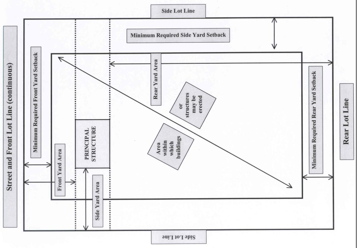
Setback The required distance of any building or structure to a front, rear, or side lot line. The setback shall be measured from the lot line to the closest point of any building or structure, excluding the eave; provided, however, that where the eave is greater than two (2) feet in width, the setback shall be measured to the eave. (Added May 2019 – ATM, Art. 32)
Sign Includes any structure, device, letter, word, insignia or representation used as or which is in the nature of advertisement, announcement or direction, including window signs visible from the exterior. Sign area shall be measured as the surface area within a single continuous perimeter enclosing all of the display area, but not including structural members not bearing advertising matter. One side only of flat, back-to-back signs shall be counted.
Single-Family Detached Dwelling A dwelling intended and designed to be occupied by a single family but not including a trailer or mobile home. (Amended March 1978 – STM, Art. 1)
Small-Scale Solar Energy System A roof or ground-mounted solar power generation system which has a rated nameplate capacity of less than 250 kilowatts (i.e. the maximum rated output of electric power production of the solar energy system in Direct Current) and is not deemed accessory to an individual residential or business use. (Added May 2012 – ATM, Art. 34)
Special Permit Granting Authority The Board of Appeals or Planning Board except as otherwise specifically designated in this by-law for the issuance of Special Permits. (Amended May 2020 – Article 36. Previously amended March 1978 – STM, Art. 1)
Street A public way or a way which the Clerk of the Town certifies is maintained and used as a public way or a way constructed in accordance with the subdivision control law and in accordance with subdivision plans approved by the Planning Board under its Rules and Regulations.
(Amended May 2000 – ATM, Article 33 and May 1995 – ATM, Article 42)
Structure Three (3) dimensional permanent improvements to real estate made with building materials which improvements include, but are not limited to swimming pools, tennis courts, basketball courts and accessory buildings. Driveways, patios, badminton and volleyball court nets (without courts), backboards above garage doors, flagpoles etc. are excluded. (Amended May 1998 – ATM, Article 43)
Trailer or Mobile Home Sometime or regularly transportable unit, by whatever name, which provides temporary or permanent facilities for living, sleeping or business use, whether with or without motor power, whether standing on wheels or other support and whether or not temporarily or permanently resting on its own foundation.
Two-Family Dwelling A dwelling intended and designed to be occupied by two families living independently in separate dwelling units. (Amended May 2001 – ATM, Art. 40)
Warehouse A building used primarily for the interior storage of goods and materials, for distribution or fulfillment, but not for sale on the premises. Warehouse facilities shall not exceed 200,000 s.f. on any lot. Warehouse facilities may not operate between the hours of 8:00 p.m. and 6:30 a.m. (Amended May 2022 – ATM, Art. 38. Previously amended May 2016 – ATM, Art. 22)
Wholesale Trade Establishments primarily engaged in selling merchandise to retailers; to industrial, commercial, institutional or professional users; to other wholesalers; or acting as agents and buying merchandise for, or selling merchandise to, such individuals or companies.
(Added May 2001 – ATM, Art. 40)
Section IIUse Districts
§ II-AClasses of Districts
For the purpose of this By-Law, the Town of Holliston is hereby divided into the following districts:
| AR-1 | Agricultural-Residential District A |
| AR-2 | Agricultural-Residential District B |
| R-1 | Residential District |
| VR | Village Residential |
| C-1 | Commercial District |
| VC | Village Center Commercial District |
| I | Industrial District |
(Note: Village Residential added May 2008 – ATM, Art. 39. Commercial District amended May 1986 – ATM, Art. 11. Industrial District amended June 1982 – STM, Art. 12. Apartment District added March 1974 – ATM, Art. 10 and deleted October 2024 – STM, Art.10)
§ II-BLocation of Districts
Said districts are located and bounded as shown on a map entitled “Town of Holliston Zoning Map” 1” = 1500’ prepared by Comprehensive Environmental Incorporated (dated September 2023). In addition, the area known as 1629-1633 Washington Street (Map 5, Block 3, Lots 78, 81 and 82) is added to the Industrial District. The map is on file in the office of the Town Clerk. The Zoning Map, with all explanatory matter thereon, is hereby made a part of this By-Law. (Amended October 20, 2025 – STM, Art. 17. Previously amended October 2023- STM, Art. 16)
Where a boundary is shown as following a street, railroad, or utility, the boundary shall be the centerline thereon unless otherwise indicated.
Where a boundary is shown outside of a street, railroad or utility and approximately parallel thereto, the boundary shall be deemed parallel to the nearest line thereof, and the figure placed on the zoning map between the boundary and such line shall be the distance in feet between them, as measured at a right angle from such line unless otherwise indicated.
Where a boundary is shown as following a watercourse, the boundary shall coincide with the center line thereof as said line existed at the date of the zoning map.
Where the location of a boundary line is otherwise uncertain, the Planning Board or Building Inspector shall determine its position in accordance with the distance in feet from other lines as given or as measured from the scale of the map.
Where a district boundary line divides a lot, the regulations applying to the portion of such lot in the less restricted district may be considered as extending not more than 50 feet into the more restricted portion, but only if the lot has frontage on a street in the less restricted district, provided, however, that there shall be no such extension into any area subject to the provisions of Section V-I.
Section IIIUse Regulations
§ IIISchedule of Use Regulations
In any district, no building or structure shall be erected or used for any purpose other than those set forth in the Schedule of Use Regulations and in accordance with the following notations:
Y - Permitted Use
SP - Use allowed under Special Permit by the Special Permit Granting Authority as provided in Section VI-D and VI-E hereinafter.
N - Prohibited Use
Permitted Uses and uses allowed by the Special Permit Granting Authority shall be in conformity with the provisions of Section IV and V of this Zoning By-Law. (Amended May 2022 – ATM, Art. 38)
| USE | AR-1 | AR-2 | R-1 | VR | C-1 | VC | I |
|---|---|---|---|---|---|---|---|
| A. RESIDENTIAL USES | |||||||
| 1. Single-family detached dwelling | Y | Y | Y | Y | N | N | N |
| 2.Two-family dwelling (See Section IV-C) | N | N | SP | SP | N | SP | N |
| 3. Alteration & conversion of single-family dwelling existing prior to the effective date of this by-law, to accommodate two or more families, provided that all intensity, off-street parking and additional residential floor area requirements are met, and exterior design of this structure is not changed from the character of a single-family dwelling excepting that the exterior of the building may be reconstructed to accommodate an exit from the second floor or other units. | Y | Y | Y | SP | SP | Y | N |
| 4. Multi-family dwellings* | N | N | N | N | N | SP | N |
| 5. Apartments | N | N | N | N | N | SP | N |
| 6. Nursing, rest or convalescent home | SP | SP | SP | N | N | N | N |
| B. INSTITUTIONAL AND EXEMPT USES | |||||||
| 1. Use of land or structures for religious purposes | Y | Y | Y | Y | Y | Y | Y |
| 2. Use of land or structures for educational purposes on land owned or leased by the commonwealth or any of its agencies, subdivisions or bodies politic or by a religious sect or denomination, or by a nonprofit educational corporation | Y | Y | Y | Y | Y | Y | Y |
| 3. Public buildings, structures and premises owned or leased by or from the municipality for their use or other uses expressly allowed elsewhere within this By-Law, or MGL C. 40A, and which may also include uses such as passive and active recreational areas, and be inclusive of structures which may exceed the height limitations to which they would otherwise be subject under Section IV-B of the Town of Holliston Zoning By-Law | Y | Y | Y | Y | Y | Y | Y |
| 4. Public Utilities | Y | Y | Y | Y | Y | Y | Y |
| 5. Public Service Corporation | SP | SP | SP | SP | SP | SP | SP |
| 6. Use of Municipal property by a Public Service Corporation or a provider of telecommunication services or a provider of a solar energy system, under lease by the Board of Selectmen after first holding a public hearing including giving notice to all abutters within 300 feet or as further governed by M.G. L. Chapter 40. | Y | Y | Y | Y | Y | Y | Y |
| 7. Library, Museum or Civic Center | SP | SP | SP | SP | SP | SP | SP |
| 8. Civic, fraternal, historical, social, educational, or other non-profit organizations whose primary function is non-commercial, with ancillary uses permitted to the extent appropriate for their support | SP | SP | SP | SP | SP | SP | SP |
| 9. Child care center or school aged child care program | Y | Y | Y | Y | Y | Y | Y |
| 10. Hospital, charitable institution, or other non-correctional institutional use | SP | SP | SP | N | N | N | N |
| C. AGRICULTURAL USES | |||||||
| 1. Horticulture, floriculture or agriculture except the raising of livestock for commercial use on parcels of less than five acres or to two qualified acres | Y | Y | Y | SP | SP | SP | SP |
| 2. Raising of poultry or livestock for commercial use on parcels of less than five acres or two qualified acres | Y | Y | SP | SP | SP | SP | SP |
| 3. Agriculture, horticulture, floriculture on parcels of five acres or more or two qualified acres | Y | Y | Y | Y | Y | Y | Y |
| 4. Salesroom or stand for the display of agricultural or horticultural products, the major portion of which is grown or produced on the premises by a resident proprietor | Y | Y | Y | Y | Y | Y | Y |
| 5. Commercial greenhouse, nonexempt | SP | N | N | N | Y | Y | Y |
| D. COMMERCIAL USES | |||||||
| 1. Educational uses or structures which are not public, religious, or run by a non-profit educational corporation duly licensed in Massachusetts | SP | SP | SP | SP | SP | Y | Y |
| 2. Privately organized camp | SP | SP | SP | SP | SP | SP | SP |
| 3. Bed and breakfast, but not including an overnight cabin, motel or hotel | SP | SP | SP | SP | SP | SP | N |
| 4. Hotel, motel, or overnight cabin | N | N | N | N | SP | SP | SP |
| 5. Retail sales, not including drive-in or outdoor retail sales | N | N | N | N | Y | Y | SP |
| 6. Personal service establishment | N | N | N | N | Y | Y** | N |
| 7. General service establishment (Amended May 2022 – ATM, Art. 38) | N | N | N | N | SP | SP | SP |
| 8. Drive-in uses and appurtenant buildings or structures | N | N | N | N | SP | N | SP |
| 9. Outdoor retail sales | N | N | N | N | SP | SP | SP |
| 10. Business or professional office | N | N | N | N | Y | Y** | Y |
| 11. Mixed office and warehouse use where not more than 20% of the gross floor area not to exceed 15,000 square feet is devoted to warehouse facilities, packaging, or fabrication and is otherwise in compliance with local, state and federal laws, rules and regulations, but not including any use which involves the manufacture, storage, transportation, discharge or disposal of hazardous, toxic or radioactive materials or which generates perceptible vibration or noise levels greater than 65 dbA at the property line | N | N | N | N | SP | SP | Y |
| 12. Undertaking establishment or funeral home | N | N | SP | N | SP | SP | N |
| 13. Commercial parking lot and/or parking charging a fee | N | N | N | N | SP | SP | SP |
| 14. Restaurant or other place serving food or beverages only to persons inside a building | N | N | N | N | Y | Y** | SP |
| 15. Restaurant with drive-in window | N | N | N | N | SP | N | SP |
| 16. Restaurant or other place serving food or beverages with either live or mechanical entertainment or which provides outdoor seating | N | N | N | N | SP | SP | SP |
| 17. Commercial indoor or outdoor amusement or recreation place or place of assembly, not including outdoor movie theater, provided that the building is appropriately insulated and maintained as to confine the noise to the premises and is located not less than one hundred feet from a residential district. | N | N | N | N | SP | SP | SP |
| 18. Country, tennis, golf or similar clubs whether or not for profit | SP | SP | SP | SP | SP | SP | SP |
| 19. Outdoor movie theater | N | N | N | N | N | N | SP |
| 20. Drive-in or open-air business and appurtenant buildings or structures | N | N | N | N | SP | SP | N |
| 21. Animal or veterinary hospital or kennel | SP | SP | SP | N | SP | SP | SP |
| 22. Adult Entertainment Uses (Amended May 2001 – ATM, Art. 41) | N | N | N | N | N | N | SP¹ |
| 23. Medical Marijuana Treatment Center/Registered Marijuana Dispensary | N | N | N | N | N | N | Y |
| E. MOTOR VEHICLE USES | |||||||
| 1. Salesroom for motor vehicle, trailers, boats, farm implements or machinery with repair services and storage permitted | N | N | N | N | SP | SP | Y |
| 2. Gasoline station with service by attendant only | N | N | N | N | SP | SP | SP |
| 3. Self-service gasoline station | N | N | N | N | SP | SP | SP |
| 4. Repair garage, auto body, soldering or welding shop | N | N | N | N | SP | SP | SP |
| 5. Electric charging station, Level Two, as principal or accessory use | N | N | N | Y | Y | Y | Y |
| F. ENERGY RELATED USES | |||||||
| 1. Small-scale solar power generation system | Y | SP | SP | SP | SP | SP | Y |
| 2. Large-scale solar power generation system | N | N | N | N | SP | N | SP |
| 3. Alternative Energy and Renewable Energy Manufacturing Facilities and Alternative Energy and Renewable Energy Research and Development Facilities | N | N | N | N | N | N | Y |
| G. INDUSTRIAL AND OUTDOOR USES | |||||||
| 1. Warehouse facility (Amended May 2022 – ATM, Art. 38) | N | N | N | N | N | N | SP |
| 2. General industrial uses including manufacturing, storage, processing, fabrication, packaging and assembly comprised of not more than 15,000 square feet of floor area devoted to such use and otherwise in compliance with local, state and federal laws, rules and regulations, but not including any use which involves the manufacture, storage, transportation, discharge or disposal of hazardous, toxic or radioactive materials (Amended May 2022 – ATM, Art. 38) | N | N | N | N | N | N | Y |
| 3. General Industrial uses including manufacturing, storage, processing, fabrication, packaging, and assembly that occupy more than 15,000 square feet of floor area not including Warehouse, or those no more than 15,000 square feet of floor area involve the manufacture, storage, transportation, discharge or disposal of hazardous, toxic, or radioactive materials (Amended May 2022 – ATM, Art. 38) | N | N | N | N | N | N | SP |
| 4. Craft Marijuana Cultivator Cooperatives, M Cultivators, Independent Testing Labs., Marijuana Product Manufacturers (Added October 2018 – STM, Art. 26) | N | N | N | N | N | N | SP |
| 5. Marijuana Retailers (Added October 2018 STM, Art. 22) | N | N | N | N | N | N | N |
| 6. Marijuana Delivery Licensees (Added May 2022 – ATM, Art. 7.) | N | N | N | N | N | N | SP |
| H. ACCESSORY USES | |||||||
| 1. Accessory Dwelling Unit | |||||||
| a. Protected Use ADU | Y | Y | Y | Y | N | N | N |
| b. Other ADU | SP | SP | SP | SP | N | N | N |
| 2. Renting of 1 or 2 rooms and the furnishing of board by a resident family to no more than 3 non-transient persons | Y | Y | Y | SP | N | SP | N |
| 3. Professional office or studio of a resident dentist, attorney, architect, artist, musician, engineer or other member of a recognized profession provided that not more than 2 other persons are regularly employed therein in connection with such use, and provided that not more than 25% of the total not to exceed 400 square feet, is regularly devoted to such use | Y | Y | Y | Y | Y | Y | N |
| 4. Customary use and keeping of outdoor furniture, structures, firewood logs, recreational and other equipment appropriate to the normal occupancy of a dwelling on the lot provided that the same complies with other provisions of this By-law | Y | Y | Y | Y | Y | Y | Y |
| 5. Customary home occupation conducted by a resident of the premises provided that not more than one other person is regularly employed therein in connection with such use, and that not more than 25% of the total floor area, not to exceed 400 square feet, is regularly devoted to such use, and that there is no exterior storage of material or equipment, and that no exterior display of products is visible from the street | Y | Y | Y | Y | Y | Y | N |
| 6. Family day care home, large | SP | SP | SP | SP | SP | N | N |
| 7. Family day care home, small | Y | Y | Y | SP | SP | N | N |
| 8. Accessory uses to activities permitted as a matter of right, whether or not on the same parcel as activities permitted as a matter of right, which activities are necessary in connection with scientific development, scientific research or related production, provided that the Special Permit Granting Authority finds that the proposed accessory uses do not substantially derogate from the public good | N | N | N | N | SP | SP | SP |
| 9. Heliports, landing areas or platforms for helicopters or other hovering-type aircraft subject to an evaluation of noise and nuisance effects on business or residential occupants of the area and subject also to all national, state laws, regulations and codes pertaining hereto | N | N | N | N | N | N | SP |
| 10. Building materials and equipment exposed to view the extent actually necessary during active continuous construction work on the same lot (Added May 2022 – ATM, Art. 38) | Y | Y | Y | Y | Y | Y | Y |
| 11. Commercial open storage of raw materials, finished goods or construction equipment not associated with active permitted construction or agricultural uses (Added May 2022 – ATM, Art. 38) | SP | SP | SP | SP | SP | SP | SP |
| 12. Accessory outdoor storage clearly necessary to the operation and conduct of a permitted industrial or commercial use (Added May 2022 – ATM, Art. 38) | N | N | N | N | SP | SP | SP |
| 13. Processing of raw materials not associated with active permitted uses (Added May 2022 – ATM, Art. 38) | N | N | N | N | N | N | SP |
*Except for those multi-family dwelling units permitted by right within MBTA Communities Multi-Family Overlay districts subject to Section V-I
**Except SP for a new building over 5,000 s.f. gross floor area or an addition resulting in a building over 5,000 s.f. gross floor area.
¹No Adult Use Special Permit shall be issued to any person convicted of violating the provisions of MGL Ch. 119, Section 60 or MGL Ch. 272, Section 28. All building entries and windows shall be screened in such a manner as to prevent visual access to the interior of the establishment by the public. No sign or other like materials shall display any sexually explicit figures or words as defined in MGL Ch. 272, Section 31.
Section IVIntensity Regulations
§ IV-AGeneral Requirements
Lot Frontage (as defined in Section I-E Definitions) shall meet the requirements of the zoning district (as set forth in Section IV-B Schedule of Intensity Regulations) and shall be measured in a continuous line from one side lot line to the other side lot line, along the sideline of the street. In the case of a corner lot, the sideline of the street not used for the lot frontage shall be treated as a side lot line for the purposes of frontage measurement. (Amended ATM, May 1999, Article 38. Previously amended May 1998 – ATM, Art. 42.)
On all corner lots the required front yard dimensions shall apply from both street lines. The required side yard dimensions shall apply from all other lot lines. In all cases one street line shall be accepted as the front street line for the measurement of lot frontage. In any case, the sum of the street line and the rear line of the required front yard shall not be less than 1.8 times the required frontage.
On all corner lots, between the sidelines of intersecting streets and a straight line joining points on such sidelines ten (10) feet distant from their point of intersection or, in the case of a rounded corner, a straight line joining the points of intersection of their tangents, no building or structure may be erected and no vegetation may be maintained three (3) feet above the plane through their curb grades. (Amended May 2019 – ATM, Art. 31)
The minimum front yard dimensions required in the following schedule are to be measured from the street line where a plan for the street is on file with the Registry of Deeds or, in the absence of such a plan, from a line twenty-five feet from and parallel with the apparent centerline of the traveled way or street.
Lot width at the required front yard setback shall be measured as a straight line distance between the side lot lines and shall be no less than eighty percent (80%) of the required Lot Frontage. For corner lots, lot width shall be measured parallel of the frontage.
(Amended ATM, May 1999, Article 48. Previously amended May 1997 – ATM, Art. 36.)
Lots which are so distorted in configuration as to be detrimental to public health, safety, welfare or convenience, even though complying with the dimensional requirements established herein, shall not be allowed.
A lot or parcel of land containing two or more dwellings existing at the time of adoption of this by-law which cannot be divided in conformity with these requirements may, under a Special Permit by the Board of Appeals, be divided in a manner complying as closely as possible with these requirements.
No dwelling or other structure, other than a grave or grave-marker, shall be constructed within 200 feet of the high water line of any natural pond, the area of which is 20 acres or more, except that any existing dwelling, building or structure may be expanded up to twenty-five (25) per cent as long as such expansion conforms to the requirements of Section IV-B. (Amended May 1977 – ATM, Art. 17)
An owner or user of property in an Industrial or Commercial District may not make use of any lot in an Agricultural-Residential, Residential or Apartment district for access to such Industrial or Commercial property unless a private or public way through such a lot is specifically zoned for such access. (Amended May 1986 – ATM, Art. 10)
No new common drive shall be constructed except that the Planning Board may grant by Special Permit the use of a common driveway serving not more than three lots, when such lots already comply with Chapter 41 Section 81-P for Approvals Not Required under Subdivision Control Laws, and when the proposed common drive conforms to all rules and specifications as set forth by the Planning Board. (Amended May 1995 – ATM, Art. 42)
§ IV-BSchedule of Intensity Regulations
| Minimum Lot Dimensions (Continuous) | Minimum Yard Setbacks | Max. Height of Building or Structure | ||||||||
|---|---|---|---|---|---|---|---|---|---|---|
| District | Area (s.f.) | Frontage (feet) | Lot Depth (feet) | Front (feet) | Side (feet) | Rear (feet) | Stories | Feet | Max. % Coverage: Buildings, Structures & Accessory Buildings | Floor Area Ratio (FAR) |
| Ag-Res Dist. A | 80,000 | 225 | 300 | 40 | 40 | 40 | 2 1/2 | 35 | 20 | -- |
| Ag-Res Dist. B | 40,000 | 180 | 200 | 40 | 30 | 40 | 2 1/2 | 35 | 25 | -- |
| Residential Dist. | 30,000 | 120 | 150 | 30 | 20 | 30 | 2 1/2 | 35 | 30 | -- |
| Vil. Res. Dist. | 10,000 | 70 | 50 | 15 | 15 | 15 | 3 | 40 | 50 | -- |
| Vil. Ctr. Comm. Dist. | 5,000*** | 70 | 50 | 10** | 15** | 15** | 3 | 40 | 50** | 1.00 |
| Comm. Dist. | 15,000 | 80 | 120 | 10 | 15 | 20 | 3 | 40 | 50 | 0.50 |
| Industrial Dist. | 20,000 | 100 | 150 | 30 | 20 | 30 | 3 | 40 | 40 | 0.50 |
Exceptions:
* - or such modification as the Board of Appeals may allow;
** - except that the Board of Appeals may authorize the reduction of yards to zero and an increase in coverage to 80%, subject to Section V-K5
*** - additional area may be necessary to meet Board of Health requirements for sewage disposal.
-- - no specified ratio.
Walls specifically designed as impermeable barriers for the proper installation of sub-surface sewage disposal systems, and those designed and constructed in accordance with plans approved as part of a subdivision approval by the Planning Board shall be exempt from the setback requirements within the Schedule of Intensity Regulations. For all ground-mounted small- and large-scale solar power generation systems, minimum perimeter setbacks shall be 50 feet from any component to any lot line. (Amended October 2024 – STM, Art. 10. Previously amended May 2012 – ATM, Art. 34, May 2008 – ATM, Art. 39, May 1998 – ATM, Art. 45, May 1997 – ATM, Art. 30, May 1986 – ATM, Art. 11, March 1974 – ATM, Art. 10, and April 1970 – ATM, Art. 20.)
§ IV-CModification and Exceptions
Where two or more requirements in this by-law are applicable to the same open space, that which imposes the greatest restriction on the placement of the building will control.
In all districts 2,000 square feet of lot area shall be required for each room to be used by transient paying guests. This requirement shall be in addition to the area requirements of the district for any other use.
In all districts (except Village Center Commercial and MBTA Communities Multi-Family Overlay districts, as provided in Section V-K and V-I respectively), 10,000 square feet of lot area shall be required for the second dwelling in a two family dwelling, or a multi-family dwelling with the exception of an Accessory Dwelling unit, as regulated under Section V-G(A). This requirement shall be in addition to the area requirements of the district for any other use. (Amended October 2024 – STM, Art. 10 & 11. Previously amended June 1982 – STM, Art. 12)
In all districts (except Village Center Commercial district and MBTA Communities Multi-Family Overlay districts, as provided in Section V-K and V-I respectively), 5,000 square feet of lot area shall be required for all dwellings other than the first and second in multi-family dwellings. This requirement shall be in addition to the area requirements of the district for any other use. (Amended October 2024 – STM, Art. 10. Previously amended March 1974 –ATM, Art. 10)
Section VSpecial Regulations
§ V-AAccessory Buildings and Structures
No accessory building or structure shall be located within the required front yard area. No accessory building, structure, or appurtenant element, (e.g. pool decks, concrete aprons, heating or air conditioning equipment, or other similar elements which are accessory to the building or structure) shall be constructed, altered or related so that any part thereof shall be less than 10 feet (10’) from any other building or structure or in any side yard area nearer to the side lot line than ten feet, or in the rear yard nearer than five feet. Freestanding non-commercial solar energy collection apparatus and wind energy systems (i.e. designed or operated and intended for single residential or business uses) are considered to be accessory structures and uses. In no case shall accessory buildings or structures cover more than 30% of the required rear yard area. (Amended October 2024 – Art. 11. Previously amended May 2009 – ATM, Art. 29 and May 1995 – ATM, Art. 42.)
§ V-BExterior Signs
(Amended May 2010 – ATM, Art. 33. Note: Replaced prior text in its entirety.)
General Sign Prohibitions
Signs that move or flash, or are animated.
Billboards as defined and regulated by MGL c. 93, s. 30.
Strings of banners, pennants, ribbons, streamers and spinners or similar devices used as advertising.
Signs within or projecting over a public right-of-way or on public property except with a permit from the Board of Selectmen.
Off-premise signs not specified below.
General Regulations
The illumination of any sign shall be shaded, shielded, directed and maintained at sufficiently low intensity and brightness that shall not affect the safe vision of vehicle operators. Red and green lights shall not be used for illumination.
District Regulations
All residential zoning districts (AR-1, AR-2, R-1 and VR)
Signs which require permits:
One non-flashing sign not over twelve (12) square feet in area and six (6) feet in height pertaining to permitted buildings, structures and uses of the premises other than dwellings and their accessory uses.
Exempted signs:
One non-flashing sign for each family residing on the premises indicating the name of the owner or occupant or pertaining to a permitted accessory use, provided that each such sign does not exceed two square foot in area and if freestanding, does not exceed six (6) feet in height.
Temporary unlighted signs aggregating not over eighteen square feet in area pertaining to the sale or lease or construction of the premises. No signs placed on individual lots shall exceed six (6) square feet.
Temporary contractor signs not to exceed nine (9) square feet. Signs shall be removed promptly after completion of work.
On-premise directional signs not to exceed two (2) square feet in area or six (6) feet in height.
Unlighted off-premise directional signs not exceeding two (2) square feet in area pertaining to churches, schools, institutions and other public or non-profit uses or to salesrooms or stands for the display of agricultural or horticultural products permitted under #12 of Section III-A Schedule of Uses with permission of the landowner.
Commercial and Village Center Commercial Districts
Signs which require permits:
Non-flashing signs attached to a building (wall, projecting or awning) shall not exceed forty square feet or 15% of the building’s façade area, whichever is less, nor shall they obscure architectural details of historic structures. Permanently affixed window signs shall not occupy more than 10% of the window surface area. In the Village Center Commercial District signs must not be internally lit. In no case shall a sign project above a parapet wall.
One freestanding sign for each separate and distinct establishment on the premises. Each sign shall not exceed twelve square feet in area unless otherwise authorized by Special Permit from the Special Permit Granting Authority. Freestanding signs must be less than 10 feet high and shall not be erected in any way that creates a traffic hazard or obstructs traffic. Freestanding signs are permitted to be laddered in the case of multi-tenant facilities and may have changeable text. In the case of multi-tenant ladder signs, individual business signs shall be limited to twelve (12) square feet and the height may be increased to fifteen (15) feet.
Roof signs and murals may be authorized by Special Permit from the Special Permit Granting Authority.
Exempted signs:
Un-lit temporary window signs with less than 10% of the window area covered.
Accessory signs not identifying a business (e.g. Open, Closed, Vacancy, Hours of Operation) not to exceed six (6) square feet.
On-premise directional signs not to exceed two (2) square feet in area or six (6) feet in height.
Industrial District
Signs which require permits:
Non-flashing signs attached to a building (wall, projecting or awning) shall not exceed forty square feet in area or 15% of the building’s façade area, whichever is less. In no case shall a sign project above a parapet wall.
One freestanding sign for each separate and distinct establishment on the premises. Each sign shall not exceed forty square feet in area. Freestanding signs must be less than 10 feet high, set back a minimum of 10 feet from the front lot line and shall not be erected in any way that creates a traffic hazard or obstructs traffic. Freestanding signs are permitted to be laddered in the case of multi-tenant facilities and may have changeable text. In the case of a multi-tenant ladder sign, individual business signs shall be limited to 15 square feet and height may be increased to 15 feet.
Exempted signs:
Un-lit temporary window signs with less than 10% of the window area covered.
Accessory signs not identifying a business (e.g. Open, Closed, Vacancy, Hours of Operation) not to exceed six square feet.
On-premise directional signs not to exceed two (2) square feet in area or six (6) feet in height.
Non-Conforming Uses
Signage not exceeding twelve (12) square feet (attached and/or freestanding) is allowed for any non-conforming use, unless otherwise authorized by Special Permit from the Special Permit Granting Authority.
§ V-COff-Street Parking
(Amended May 2004 – ATM, Art. 28. Previously amended March 1982 – ATM, Art. 35)
Performance Requirement - Adequate parking must be provided to service any net increase in parking demand created by new construction, additions, or changes of use, and existing off-street parking must not be changed such that these requirements are no longer met. However, no off-street parking is required for non-residential uses in the Village Center Commercial District. Section V-C(3) Parking Area Location and Design Requirements apply in all districts. (Amended June 1982 – STM, Art. 12)
Number of Spaces - The standards below must be met for the additional parking demand created by new buildings, additions, or changes of use unless, following consultation with the Planning Board, the Building Inspector determines that special circumstances dictate a different provision in order to meet all parking needs. Examples of such circumstances include mixed uses with staggered peak parking hours, businesses with vanpooling arrangements or unusual building occupancy (e.g. by the elderly). No storage, display, or loading area shall be counted as parking space. In a Commercial District, on-street parking may be counted towards satisfying these requirements if located between lot sidelines on the same side of a street having 30 feet or more traveled way width and having curbing and sidewalk. (Amended May 1986 – ATM, Art. 11)
Dwellings: Two (2) parking spaces for each dwelling unit therein, except one parking space for each dwelling unit having fewer than two rooms which are used or usable as bedrooms.
Places of public assembly including churches: one parking space for each three (3) persons capacity based on the State Building Code.
Hotels, motels, commercial accommodations: one parking space for each guest unit, plus one parking space for each eight units or fraction thereof.
Restaurant: one parking space per 2 1/2 persons seating capacity.
Commercial recreation: one space per two persons participant capacity, plus one space per three persons spectator capacity.
Other service establishments and retail businesses: one parking space per 180 square feet gross floor area (excluding basement storage area), but not less than three spaces per separate enterprise.
Wholesale and industrial establishments: one parking space per 1.3 employees on the largest shift, but capable of expansion to not less than one space per 300 square feet gross floor area, plus loading space for all delivery and shipping trucks.
Business or professional office: one parking space per 250 square feet of gross floor area.
Medical office or clinic: one parking space per 200 square feet of gross floor area.
Other uses: a number of spaces to be determined by the Planning Board, if the provisions of Section VII(2)(b) apply, or Building Inspector, based upon evidence from similar uses in similar circumstances, or by guidelines produced by the Institute of Transportation Engineers, such as the document titled: Parking Generation, or similar professional documents.
(Amended May 2019 – ATM, Art. 31)
Parking Area Location and Design.
Location - Required parking shall be either on the same premises as the activity it serves, or on a separate parcel if the parcel is located within 300 feet of the building entrance to be served, is in the same ownership or under recorded agreement, and is in a zoning district allowing the activity it serves. Parking areas shall be separated from street and property lines by an area not less than five feet in width maintained with landscaping except where crossed by driveways.
Configuration - Dimensions of spaces and aisles shall adequately provide for clearance and movement. The Planning Board shall adopt and from time to time amend standards for such dimensions, reflecting current vehicle sizes. At least 10% of the interior of any parking lot having 40 or more spaces shall be maintained with landscaping, including trees, in plots of at least four feet in width. Trees and soil plots shall be so located so as to provide visual relief and sunlight and wind interruption within the parking area, and designed to assure safe patterns of internal circulation. In the Village Center Commercial District, the landscaping dimensional requirements may be relaxed at the discretion of the Building Inspector or the Planning Board.
Surface - Off-street parking areas, loading areas, and access drives, if involving six or more parking spaces, shall be surfaced with bituminous or other paving material unless the Planning Board, if the provisions of Section VII (2) (b) apply, or Building Inspector approves an alternative surface which, because of only seasonal or periodic use, will adequately prevent dust, erosion, water accumulation and unsightly conditions.
Lighting - Illumination shall use cut-off luminaires mounted no higher than fifteen feet, arranged and directed so as to create no glare off-site and to add not more than one foot-candle to illumination levels at any point off-site.
Backing - Parking areas having three or more spaces shall be so designed that no vehicle will be required to back on a public way in order to enter or exit from a parking space.
Egress - There shall be not more than two driveway openings onto any street from any single premises unless each opening centerline is separated from the centerline of all other driveways serving 20 or more parking spaces, whether on or off the premises, by 150 feet (measured at the street line). No such opening shall exceed twenty-four (24) feet in width at the street line unless necessity of greater width is demonstrated by the applicant, and the opening is designed consistently with Planning Board standards adopted pursuant hereto. Openings shall be located so as to minimize loss of on-street parking spaces, and shall be graded and drainage facilities provided where necessary to prevent stormwater from running across any sidewalk or ponding. No driveway sideline shall be located within twenty (20) feet of the street line of an intersecting way. All driveways serving five (5) or more parking spaces shall be constructed with a minimum edge radius of five (5) feet on both sides. All driveways serving forty (40) or more parking spaces must have not less than 250 feet visibility in each travel lane entering a state-numbered or maintained highway, and not less than 150 feet visibility on other streets.
Parking Lot Plantings - All plantings shall be of a species characterized by suitability and hardiness for location in a parking lot. To the extent practical, existing trees shall be retained and used to satisfy the provisions of this section. Trees and plantings that die within one year shall be replaced by the owner.
The border separating the parking area from the streets and property lines shall contain landscaping that;
Minimizes visual impact
Is positioned to assure proper sight distance for vehicles and pedestrians.
Bicycle Racks - For parking areas of forty or more spaces, bicycle racks facilitating locking shall be provided to accommodate one bicycle per twenty parking spaces required or fraction thereof.
Special Permit – The Planning Board may, by Special Permit, reduce the requirements of this Section if specific site or public safety considerations warrant such a reduction and no substantial detriment shall result. (Amended May 2019 – ATM, Art. 31)
§ V-DReserved
§ V-ERemoval of Earth Products
(Amended June 1972 – STM, Art. 6. Previously amended June 1968 – ATM, Art. 6)
The removal from any premises of more than ten (10) cubic yards of earth products, including sod, loam, sand or gravel, shall be prohibited except when incidental to and in connection with the construction of a building or street or other activity authorized by this by-law or General By-Laws Article XLI Stormwater Management and Land Disturbance By-Law.
Opening of new sand or gravel pits may be authorized by the Board of Appeals by special permit, provided it determines that the activities involved are not harmful or detrimental to the present or future character of the neighborhood or to the town. Before issuing such a special permit, the petitioner shall file a bond or other security satisfactory to the Board to guarantee performance of the conditions of the special permit. The permit issued shall be granted only to the petitioner as a personal right and shall not be transferable. (Amended April 1973 – ATM, Art. 20)
In all areas which are disturbed, topsoil removed therefrom shall be stockpiled on site until completion of operations and promptly thereafter each disturbed area on which structures, parking lots or ways are not in place, shall be re-covered with topsoil to a depth of at least that which previously existed, but, in any event, with no less than four (4) inches of compacted topsoil in the uppermost layer.
Removal of earth products other than specifically permitted in this by-law or in the general Town by-law is prohibited.
§ V-FArchitectural Controls
(Amended March 1978 – STM, Art. 1)
The exterior architectural features of houses placed or erected in a development shall be basically dissimilar. No application to place or erect two or more houses upon contiguous lots shall be approved by the Inspector of Buildings unless the applicant shall have filed with the Inspector of Buildings plans showing the houses. If there is proposed to be built or placed upon such lots more than five houses, there shall be at least three basic designs. If there is proposed to be built or placed upon such lots, two, three, four or five houses, there shall be at least two basic designs.
§ V-GReserved
§ V-G(A)Accessory Dwelling Unit
(Amended October 2024 – STM, Art. 11. Previously amended May 1995 – ATM, Art. 43)
The intent and purpose of this section is to permit accessory dwelling units in single family residential districts subject to the standards and procedures hereinafter set forth. It is also the intent to assure that the single-family character of the neighborhood will be maintained and that the accessory unit remain subordinate to the principal use of the living quarters. ADUs may not be used as Short-Term Rentals, as such terms is defined in G.L. c. 64G, s. 1 or otherwise rented for a period shorter than thirty-one (31) days.
Restrictions:
Intensity Regulations for Detached Units
| Zoning District | Max. % Coverage: Buildings, Structures & Accessory Buildings | Front Yard Setback (ft) | Side Yard Setback (ft) | Rear Yard Setback (ft) | Building Separation (ft) |
|---|---|---|---|---|---|
| Ag-Res Dist-A | 20 | 40 | 10 | 5 | 10 |
| Ag-Res Dist-B | 25 | 40 | 10 | 5 | 10 |
| Residential | 30 | 30 | 10 | 5 | 10 |
| Village Residential Dist. | 50 | 15 | 10 | 5 | 10 |
Intensity Regulations for Attached Units
Attached units shall meet the requirements of Section IV-B Schedule of Intensity Regulations applicable to the principal dwelling.
Adequate provisions shall be made for the proper disposal of sewage, waste and stormwater management generated by the accessory unit in accordance with the requirements of the Board of Health and Planning Board.
Adequate provisions as determined by the Building Inspector as being in compliance with the Massachusetts State Building Code for separate Ingress, Egress, to the outside of each unit. To the extent possible, exterior passage ways and access ways shall not detract from the single family appearance of the dwelling. All stairways to additional floors shall be enclosed within the exterior walls of the structure.
Construction of an attached Accessory Dwelling Unit within or to a pre-existing non-conforming structure may require a Special Permit per Section I-C(3), provided that no Special Permit may consider the ADU use or impose conditions specific to such use. In the case of a Protected Use ADU only, an ADU that is nonconforming to zoning shall still qualify as a Protected Use ADU if it otherwise meets the definition per 760 CMR 71.02. In the case of a pre-existing Protected Use ADU, the Protected Use ADU does not need to comply with use or dimensional requirements that were imposed as a condition for the prior approval.
Floor plans and building elevations for the accessory unit and the principal residence, along with a certified site plan shall be submitted along with the application.
Off-Street Parking shall be provided for residents of both units in accordance with Section V-C of the By-Laws. One (1) space shall be provided for residents of an ADU. In the case of a Protected Use ADU, no additional on-street or off-street parking space is required if any portion of its lot is located within a 0.5-mile radius of a transit station as defined in 760 CMR 71.02.
In Zone II Groundwater Protection Districts and other locations with nitrogen loading restrictions, the underlying intensity and lot coverage standards per Section V-L(4)(D) and Title 5 (310 CMR 15.214) shall apply.
An ADU that does not meet the definition of Protected Use ADU and more than one ADU may be allowed by Special Permit. No Special Permit shall be issued unless the Special Permit Granting Authority finds that the exterior appearance of the ADU and any accessory structure modified to accommodate a detached ADU will maintain the essential character of the neighborhood and will be compatible with the principal dwelling on the same lot and with other dwellings on adjoining lots. A plan must be submitted showing the proposed interior and exterior changes to the principal dwelling. Proof that the on-site wastewater treatment system is suitable for the increase in the number of bedrooms must also be provided by a Professional Engineer or Registered Sanitarian.
No occupancy of the additional dwelling unit shall take place without an occupancy permit issued by the Building Inspector.
§ V-HOpen Space Residential Development
(Adopted May 2007 – ATM, Art. 46)
Purpose
To encourage permanent preservation of open space, agricultural land, forest, forestry land, wildlife habitat, other natural resources including aquifers and watersheds, water bodies and wetlands, and historical and archeological resources.
To conserve and create scenic views, to protect views along scenic roadways, and, where appropriate, to preserve the rural character of the Town.
To allow for greater flexibility and creativity in the design of residential developments.
To minimize the total amount of disturbance of subdivision sites.
To discourage sprawl and encourage development that consumes less open land.
To facilitate the construction and maintenance of housing, streets, utilities and public service in a more economic and efficient manner.
To provide a buffer between new development and existing streets, neighborhoods, active farmland and adjacent park or conservation land.
To provide for the maintenance of open land set aside for active or passive recreational use, stormwater management or conservation lands.
To create neighborhoods with direct visual and/or physical access to open land and with a strong neighborhood identity.
To advance and be consistent with the goals, objective and strategies of the Town’s Master Plan and Open Space and Recreation Area Plan.
Applicability
Open Space Residential Development (OSRD) projects are permitted by right within both Agricultural-Residential A & B (AR-1 and AR-2) and Residential (R-1) zoning districts in accordance with the additional requirements of Site Plan Review and definitive subdivision approval specified herein.
No subdivision creating two or more lots from any parcel or set of contiguous parcels in common ownership as of the effective date of by-law may be approved except pursuant to Site Plan Review under the provisions of this section and Section VII of the by-laws. Where the Planning Board finds upon the written request of the Applicant that an OSRD will not achieve the purposes of this section as effectively as a conventional subdivision, this section shall not apply.
General Requirements
Design Process
The design process shall follow this sequence:
Step 1 - delineation of wetlands, topography and other site features,
Step 2 - delineation of proposed open space,
Step 3 - delineation of potential building sites (including septic systems, private yards and shared amenities),
Step 4 - location and alignment of roads, driveways and utilities
Step 5 - establishment of lot lines.
Evidence of this process shall be provided to the Planning Board during its review.
After an application has been submitted, no tree removal, no utility installation, no ditching, no grading or construction of roads, no grading of land or lots, no excavation except for purposes of soil testing, no dredging or filling, and no construction of buildings or structures shall be done on any part of the development site until the application has been reviewed and approved as provided by these regulations.
Minimum Requirements
Density: The total number of lots shall be determined by the Board using the following as guidelines:
Conventional subdivision plan (general layout) submitted by the applicant, and
Information provided by the applicant indicating the development potential of the land, including but not limited to mapping of wetland resources, soil analyses and percolation tests.
Except as provided below, the total number of lots for building purposes within the tract shown on the plan shall not be more than allowed by conventional zoning.
Intensity Regulations: In no instance shall any building lot deviate from the following table.
INTENSITY REGULATIONS
Lot Depth as defined under Section I-E and IV-B does not apply.
Lot Width as defined under Sections I-E and IV-A(6) does not apply.
Lots within an OSRD shall not have physical access on a street other than a street created by the OSRD.
Open Space. Within an OSRD, no less than fifty (50%) percent of the land area shall be devoted to common open space. The common open space shall not include land set-aside for roads and/or parking uses. No more than fifty (50%) of the minimum common open space shall contain wetlands as defined by M.G.L., C.131, Section 40.
Allowable Density Bonuses
Density bonuses may be given at the discretion of the Planning Board based upon the expected public benefit. The bonuses described below may be combined to result in a total density bonus not exceeding 100% of the density as determined in 4(A) above.
For each 80,000 s.f. of additional upland area set aside as permanently restricted open space, one additional lot may be created.
For each additional restricted affordable housing unit in excess of that required under Section V-Q, one additional lot may be created.
If the applicant preserves at least 60% of the parcel as working farmland, an additional lot may be created.
Application and Review Process
The application to the Planning Board for Site Plan Review shall include application forms, fees and any other materials required by the Planning Board under its Rules and Regulations and Section VII of the by-laws. Applications shall be filed with the Town Clerk. The application shall be reviewed in conformance with the standards of Section VII and the Planning Board’s Rules and Regulations.
The application process is comprised of two steps. In the first step, the applicant shall submit a concept plan, as outlined below, which describes the overall development plan. The Planning Board shall grant or deny a site plan application based upon the information contained in the concept plan. If the permit is granted, the applicant shall submit a definitive plan based upon the concept plan. The Planning Board shall review the plan as a definitive subdivision plan under its Rules and Regulations.
Development Standards:
Concept Plan Standards: The applicant shall submit the information necessary to demonstrate that the following standards have been met:
The development will not cause unreasonable traffic congestion or unsafe conditions both within and outside of the OSRD.
The development will provide for and maintain convenient and safe emergency vehicle access to all buildings and structures at all times.
The site design shall preserve and, where possible, enhance the natural features of the property, including scenic views, by adapting the location and placement of structures and ways to the existing topography in order to minimize the amount of soil removal, tree cutting and general disturbance to the landscape and surrounding properties.
The site design shall identify and ensure preservation of significant and special natural features.
Open Space Use and Design Standard
The common open space shall be designed and deeded as protected open space subject to the provisions of Article 97 of the amendments to the Constitution of the Commonwealth of Massachusetts and maintained in accordance with the following standards:
Areas to remain as naturally existing woods, fields, meadows, and wetlands shall be maintained and may be improved in accordance with approval by the Planning Board.
Common open space shall be planned as large, contiguous units wherever possible. Strips of narrow parcels of common open space are undesirable but may be permitted when necessary for access or as vegetated buffers along the site's perimeter.
Common open space may be in more than one parcel provided that the size, shape and location of such parcels are suitable for the designated uses.
Common open space may be used for passive recreation, conservation, forestry, agriculture, and natural buffers, subject to approval by the Planning Board.
In so far as possible, open space areas shall connect to open space areas on adjacent properties, regardless of ownership.
If detention and/or retention ponds are necessary for the construction of the improvements shown on the subdivision plan, such detention and/or retention ponds may be located within the common open space shown on such plan. Such surface systems shall not qualify towards the minimum open space required.
Open space proposed to be restricted for agricultural use shall be permanently restricted by deed and may include greenhouses, barns or stables and similar structures for housing poultry or livestock specifically permitted by the Planning Board for inclusion within said open land, but not residences, garages or other buildings.
There shall be a buffer at the perimeter of the site consisting of trees, shrubs, vegetation and topographic features sufficient to separate and/or screen the development from abutting properties. This buffer shall be no less than 1.5 times the required setback or greater if the property abuts land within Industrial or Commercial zoning districts. Buffer areas shall remain in their current natural state. If in the opinion of the Planning Board the current natural state is insufficient to adequately separate and/or screen the site from abutting properties, additional trees, shrubs and/or plantings shall be required.
Upon a finding by the Planning Board that a buffer of lesser width would be sufficient to screen and/or separate the development from adjacent property, the buffer may be reduced. The Board may require no-cut easements, conservation restrictions, or the like where the buffer requirement has been reduced. These easements and restrictions shall be on private property and shall not be included in common open space calculations.
Common Open Space Ownership and Management
Common open space in any ORSD shall be conveyed to:
The Town, and may be accepted by it for park or open space use, subject to acceptance by the Town as required by Massachusetts General Laws; or
A nonprofit corporation, the principal purpose of which is the conservation of open space; or
Homeowner’s corporation or trust.
In any case where such land is not conveyed to the Town, a conservation restriction prepared in accordance with the provisions of Section 31 and 33, inclusive, of MGL Chapter 184 enforceable by the Town shall be recorded providing that such land shall be kept in an open or natural state and shall not be built upon for residential use or developed for accessory uses such as parking or roadway. Said conservation restriction shall include appropriate provisions to ensure public access.
The applicant must include a program describing how the common open space will be maintained in perpetuity to standards satisfactory to the Planning Board.
The open space shall be available for use by the general public, unless the applicant can provide compelling reasons to the Planning Board why such access would be infeasible in whole or in part.
The applicant shall include a provision that the common open space will be deeded as approved by the Planning Board as part of the subdivision covenant. In addition, the covenant shall not be released until proof of ownership has been provided to the Planning Board.
The Planning Board may require that all or such part of the common open space as the Planning Board deems appropriate shall be clearly identified and marked on the ground prior to the commencement of any construction activity.
§ V-IMBTA Communities Multi-Family Overlay District
Purpose and Intent
The purpose of the MBTA Communities Multi-Family Overlay District (MCMOD) is to allow multi-family housing as of right in accordance with Section 3A of the Zoning Act (Massachusetts General Laws Chapter 40A). This zoning is intended to accomplish the following purposes:
Encourage the production of a variety of housing sizes and typologies to provide equal access to new housing throughout the community for households with a variety of needs and income levels.
Implement the Holliston Housing Production Plan;
Locate housing within walking distance of public transit to promote general public health, reduce the number of vehicle miles travelled, support economic development, and meet community-based environmental goals, including reducing greenhouse gases and improving air quality.
Support public investment in public transit and pedestrian- and bile-friendly infrastructure.
Increase the municipal tax base through private investment in new residential developments.
Establishment and Applicability
This MCMOD is an overlay district having a land area of approximately 76 acres in size that is superimposed over the underlying zoning districts and is shown on the map entitled "Town of Holliston - MBTA Subdistricts Location" prepared by JM Goldson (dated August 2024, revised October 21, 2024).
An applicant may develop multi-family housing located within a MCMOD in accordance with the provisions of this Section as of right without the need for a Special Permit, Variance, zoning amendment, waiver, or other discretionary zoning approval.
The MCMOD is an overlay district superimposed on underlying zoning districts. The regulations for use, dimension and all other provisions of the Zoning Bylaw governing the respective underlying districts shall remain in full force, except for uses allowed as of right in the MCMOD.
Uses that are not identified in Section V-I are governed by the requirements of the underlying zoning districts.
The MCMOD is composed of two (2) subdistricts as defined by the Assessor Maps, Blocks, and Parcels below:
Subdistrict 1 - Map 14, Block 4, Parcel 4.1, Map 14, Block 3, Parcel 232, and Map 14, Block 4, Parcel 1
Subdistrict 2 - Map 5, Block 1, Parcel 21 and Map 5, Block 4, Parcels 22 and 23.
Definitions
For purposes of this Section V-I, the following definitions shall apply. Definitions used but not included herein shall have the meaning given to them under M.G.L. c. 40A or elsewhere in the Town of Holliston Zoning By-Laws.
Affordable Housing Units. A housing unit that is subject to a use restriction recorded in its chain of title limiting the sale price or rent or limiting occupancy to an individual or household of a specified income, or both.
Building Coverage. The maximum area of the lot that can attributed to the footprint of a building (principal and accessory) on that lot. Building coverage does not include surface parking or other impervious area.
Compliance Guidelines. Compliance Guidelines for Multi-Family Zoning Districts Under Section 3A of the Zoning Act as further revised or amended from time to time.
DHCD. The Massachusetts Department of Housing and Community Development, or any successor agency.
MBTA. Massachusetts Bay Transportation Authority.
Multi-Family Housing. A building with three or more residential dwelling units or two or more buildings on the same lot with more than one residential dwelling unit in each building.
Open Space. A designated area on a lot or within a building (or combination thereof) set aside for shared use by residents for gathering, recreation, childcare and other community needs. Open Space shall include required minimum setbacks.
Permitted Uses
Uses Permitted As of Right
Multi-family housing is subject to Site Plan Review per Section VII of the Zoning By-Laws and the associated required parking for that use (surface and structured) per Section V-C Off-Street Parking.
Professional office, studio nor home occupation up to 200 s.f. with no employees and who do not have regular clients/customers come to the office.
Dimensional Standards
Notwithstanding anything to the contrary in this Zoning, the dimensional requirements applicable in the MCMOD are as follows:
| Maximum Building Height | 40 feet |
| Maximum Stories | 3 Stories |
| Minimum Lot Size | 10,000 sf. |
| Minimum Frontage | 50 ft |
| Maximum Building Coverage | 50% |
| Front Yard Setback | 10 ft |
| Side Yard Setback | 10 ft |
| Rear Yard Setback | 10 ft |
| Maximum Units per acre* | 17 |
| Open Space | 30% |
Special Permit required for higher density
Exceptions.
Renewable Energy Installations. The Planning Board as Site Plan Review Authority may waive the height and setbacks defined in this section to accommodate the installation of solar photovoltaic, solar thermal, living and other eco-roofs, energy storage, and air-source heat pump equipment. Such installations shall not create a significant detriment to abutters in terms of noise or shadow and must be appropriately integrated into the architecture of the building and the layout of the site. The installations shall not provide additional habitable space within the development.
Off-Street Parking
These parking requirements are applicable to development in the MCMOD
Number of parking spaces. The following maximum numbers of off-street parking spaces shall be permitted by use, either in surface parking or within garages or other structures:
| Use | Maximum Space Per Dwelling unit |
|---|---|
| Studio or 1-Bedroom Units | 1 per unit |
| 2- or 3+ Bedroom Units | 2 per unit |
Number of bicycle parking spaces – No fewer than 5 covered bicycle parking spaces shall be integrated into the structure of the building(s) in projects greater than 10 units.
General Development Standards.
All developments in the MCMOD are subject to the following development standards regardless of size, building count or subdistrict. These standards shall be considered components of the Site Plan Review process specified in Section VII - Site Plan Review.
Site Design
Connections. Sidewalks shall provide direct connections among building entrances, the public sidewalk (if applicable), bicycle storage, and parking. Connections shall be designed to ensure the safety and convenience of persons traveling within or through the parking area and between the parking areas, the buildings, and the street. Additionally, ADA-compliant sidewalks shall be provided along the entire frontage of the subject property along existing public ways. The Planning Board may approve alternative provisions or waive requirements of this standard in situations where sidewalk construction or use is not feasible or practical.
Vehicular Access. Where feasible, curb cuts shall be minimized, and shared driveways encouraged.
Screening for Parking. Surface parking adjacent to a public sidewalk shall be screened by a landscaped buffer of sufficient width to allow the healthy establishment of trees, shrubs and perennials, but no less than six feet (6’). The buffer may include a fence or wall of no more than three feet in height unless there is a significant grade change between the parking and the sidewalk.
Parking materials. The parking surface may be concrete, asphalt, decomposed granite, bricks, or pavers, including pervious materials but not including grass or soil not contained within a paver or other structure.
Plantings. Plantings shall include species that are native or adapted to the region. Plants on the Massachusetts Prohibited Plant List, as may be amended, shall be prohibited.
Lighting. Light levels shall meet or exceed the minimum design guidelines defined by the Illuminating Engineering Society of North America (IESNA) and shall provide illumination necessary for safety and convenience while preventing glare and overspill onto adjoining properties and reducing the amount of skyglow.
Mechanicals. Mechanical equipment at ground level shall be screened by a combination of fencing and plantings. Rooftop mechanical equipment shall be screened if visible from a public right-of-way.
Dumpsters. Dumpsters shall be screened by a combination of fencing and plantings. Where possible, dumpsters or other trash and recycling collection points shall be located within the building.
Stormwater management. Proposed design shall implement strategies that demonstrate compliance of the construction activities and the proposed project with the most current versions of the Massachusetts Department of Environmental Protection Stormwater Management Standards, the Massachusetts Stormwater Handbook, Massachusetts Erosion and Sedimentation Guidelines, and, if applicable, additional requirements under the Town of Holliston’s Stormwater Management and Land Disturbance By-Law (Article XL of the Town of Holliston General By-Law) for projects larger than 10,000 s.f.
Buildings: Multiple buildings on a lot.
Parking and circulation on the site shall be organized so as to reduce the amount of impervious surface. Where possible, paring and loading areas shall be connected to minimize curb cuts on public rights-of-way.
The building(s) adjacent to the public street shall have a pedestrian entry facing the public street.
Principal Façade and Parking. Parking shall be subordinate in design and location to the principal building façade.
Integrated garages. The principal pedestrian entry into the building shall be more prominent in design and placement than the vehicular entry into the garage.
Parking structures. Buildings dedicated to structures parking on the same lot as one or more multi-family buildings or mixed-use development shall be subordinate in design and placement to the multi-family building(s) on the lot.
Waivers. Upon the request of the applicant and subject to compliance with the Compliance Guidelines, the Planning Board as Site Plan Review Authority may waive the requirements of this section in the interests of design flexibility and overall project quality, and upon a finding of consistency of such variation with the overall purpose and objectives of the MCMOD.
Affordability Requirements
Applicability. This requirement is applicable to all multi-family developments with ten (10) or more dwelling units, whether new construction, substantial rehabilitation, expansion, reconstruction, or residential conversion. No project may be divided or phased to avoid the requirements of this section.
In applicable projects, not fewer than 10% of housing units constructed shall be Affordable Housing Units. For purposes of calculating the number of units of Affordable Housing required within a development, a fractional unit shall be rounded down to the next whole number. The Affordable Units shall be available to Qualified affordable housing unit purchasers as defined under Section V-Q., that is, households earning income up to 80% of the Area Median Income (AMI) and must be eligible for listing on DHCD’s Subsidized Housing Inventory.
Development Standards. Affordable Units shall be:
Integrated with the rest of the development and shall be compatible in design, appearance, construction and quality of exterior and interior materials with the other units and/or lots.
Dispersed through the development.
Located such that the units have equal access to shared amenities, including light and air, and utilities within the development.
Distributed proportionately among nit sizes.
Distributed proportionately across each phase of a phased development.
Occupancy permits for Affordable Units shall be issued on a pro rata basis along with market-rate units.
Fee In Lieu, Location of units and Density Bonuses. Affordable Units shall not be bypassed with any fee in lieu contribution, on- or off-site land donation to the Town or density bonus allowed under Section V-Q Inclusionary Housing.
Administration. The Inspector of Buildings shall be responsible for administering and enforcing the requirements of this section.
Affordable Housing Deed Rider. All Affordable Housing Units shall have an Affordable Housing Deed Rider that regulates the future resale of the unit as per Section V-Q (11). This Deed Rider is to ensure that the unit is not converted to a market-rate value unit in the future.
§ V-JFlood Plain Overlay District Regulations
(Amended May 2025 – ATM, Art. 31. Previously amended May 2016 - ATM, Art. 2, May 2014 – ATM, Art. 31 and May 2010 – ATM, Art. 37)
Purposes - In addition to the purpose in Section I-A of this by-law the purposes of this zone are:
To provide that lands in the Town of Holliston, subject to seasonal or periodic flooding as described hereinafter shall not be used for residence or other purposes in such a manner as to endanger the health or safety of the occupants thereof or the public generally or to burden the public with costs resulting from unwise individual choices of land use.
To protect, preserve and maintain the water table and water recharge areas within the Town so as to preserve present and potential water supplies and prevent pollution of surface and ground water for the public health and safety of the Town and the watershed areas served by the Town.
To assure the continuation of the natural flow pattern of the water courses within Holliston and to preserve natural and manmade flood water storage areas so as to protect persons and property against the hazards of flood inundation.
Ensure public safety through reducing the threats to life and personal injury.
Eliminate new hazards to emergency response officials.
Prevent the occurrence of public emergencies resulting from water quality, contamination, and pollution due to flooding.
Avoid the loss of utility services which f damaged by flooding would disrupt or shut down the utility network and impacts regions of the community beyond the site of the flooding.
Eliminate costs associated with the response and cleanup of flooding conditions.
Reduce damage to public and private property resulting from flood waters.
Flood Plain District
The Floodplain District is hereby established as an overlay district. The District includes all special flood hazard areas within the Town of Holliston designated as Zone A and, AE on the Middlesex County Flood Insurance Rate Map (FIRM) issued by the Federal Emergency Management Agency (FEMA) for the administration of the National Flood Insurance Program. The map panels of the Middlesex County FIRM that are wholly or partially within the Town of Holliston are panel numbers 25017C0620F, 25017C0629F, 25017C0633F, 25017C0634F, 25017C0636F, 25017C0637F, 25017C0641F and 25017C0642F, 25017C0610G, 25017C27G, 25017C0628G and 25017C631G Community No. 250195, effective July 8, 2025. The exact boundaries of the District may be defined by the 1%-chance base flood elevations shown on the FIRM and further defined by the Middlesex County Flood Insurance Study (FIS) report dated July 8, 2025. The FIRM, Flood Hazard Boundary Map and FIS report are incorporated herein by reference and are on file with the Town Clerk, Planning Board, Conservation Commission and Inspector of Buildings.
The floodplain management regulations found in this Floodplain Overlay District section shall take precedence over any less restrictive conflicting local laws.
The degree of flood protection required by this bylaw is considered reasonable but does not imply total flood protection.
Designation of Community Floodplain Administrator
The Town of Holliston hereby designates the position of Inspector of Buildings to be the official floodplain administrator for the Town.
Use and Development Regulations.
The Town of Holliston requires a permit for all proposed construction or other development in the floodplain overlay district, including new construction or changes to existing buildings, placement of manufactured homes, placement of agricultural facilities, fences, sheds, storage facilities or drilling, mining, paving and any other development that might increase flooding or adversely impact flood risks to other properties. The Town’s permit review process includes the requirement that the proponent obtain all local, state and federal permits that will be necessary in order to carry out the proposed development in the floodplain overlay district. The proponent must acquire all necessary permits, and must demonstrate that all necessary permits have been acquired.
All development in this district, including structural and non-structural activities, whether permitted by right or by special permit must be in compliance with Chapter 131, Section 40 of the Massachusetts General Laws and with the following: 780 CMR; 310 CMR 10.00 and 13.00 Wetlands Protection Regulations and Inland Wetlands Restriction, and 310 CMR 15, Title 5 Minimum Requirements for the Subsurface Disposal of Sanitary Sewage. Any variances from the provisions and requirements of the above referenced state regulations may only be granted in accordance with the required variance procedures of these state regulations.
Permitted Uses
The following uses of low flood damage potential which cause no obstructions to flood flows shall be allowed provided they are permitted in the underlying district and they do not require structures, fill or storage of materials and equipment: 1. uses directly related to the conservation of water, plants and wildlife; 2. outdoor recreation activities and facilities, including unpaved play areas, nature study, boating, fishing and hunting where otherwise legally permitted; 3. wildlife management area, landings, foot, bicycle and/or horse paths and bridges, provided such uses do not affect the natural flow pattern of any water courses; 4. grazing and farming, including truck gardening and harvesting of crops; 5. forestry, plant nurseries and orchards.
Special Permit Uses
No construction requiring any utility, including electric, water, gas and telephone lines, or waste disposal or drainage facilities shall be permitted within the zone unless the Special Permit Granting Authority (SPGA) grants a Special Permit, based on a determination that all utilities are located and constructed so as to minimize or eliminate flood damage.
No crossing of a wetland shall be permitted within the zone unless the SPGA grants a Special Permit based on a determination that no reasonable alternative access to land otherwise inaccessible exists and that such access way is constructed so as to avoid significant alteration of wetlands, significant reduction of flood storage capacity and minimizes or eliminates damage due to flooding. In a riverine situation, the Town of Holliston shall notify adjacent communities, the NFIP State Coordinator and FEMA Region I NFIP Program Specialist of alteration or relocation of a watercourse.
Prohibited Uses
No existing building, structure or use which has been deemed non-conforming shall be extended, changed or altered so as to increase its ground coverage by more than a total of twenty (20) percent; except as allowed by Special Permit under Section I-C of this by-law.
No dumping, filling, excavation or relocation of earth products or other site alteration not herein provided for shall be permitted.
Floodway Encroachment
In Zones A1-30 and AE, along watercourses that have a regulatory floodway designated, the best available Federal, State and local, or other floodway data shall be used to prohibit encroachments in floodways which would result in any increase in flood levels within the community during the occurrence of the base flood discharge.
In Zones A1-30 and AE, along watercourses that have a regulatory floodway designated on the Middlesex County FIRM, encroachments are prohibited, including fill, new construction, substantial improvements, or other development within the adopted regulatory floodway unless it has been demonstrated through hydrologic and hydraulic analyses performed in accordance with standard engineering practice that the proposed encroachment would not result in any increase in flood levels within the community during the occurrence of the base flood discharge.
Unnumbered A Zones
In A Zones, in the absence of FEMA Base Flood Elevation data and floodway data, the building Department will obtain, review and reasonably utilize base flood elevation and floodway data available from a Federal, State or other source as criteria for requiring new construction, substantial improvements or other development in Zone A as the basis for elevating residential structures to or above base flood level, for floodproofing or elevating nonresidential structures to or above base flood level , and for prohibiting encroachments in floodways.
AO and AH Zones – Drainage Requirements
Within Zones AO and AH on the FIRM, adequate drainage paths must be provided around structures on slopes, to guide floodwaters around and away from proposed structures.
Subdivision Proposals
All subdivision proposals must be designed to assure that: a. such proposals minimize flood damage, b. all public utilities and facilities are located and constructed to minimize or eliminate flood damage; and c. adequate drainage is provided to reduce exposure to flood hazards. When proposing subdivisions or other developments greater than 50 lots or 5 acres (whichever is less), the proponent must provide technical data to determine the base flood elevations for each developable parcel shown on the design plans.
In A, A1-30, AH, AO and AE Zones, all recreational vehicles to be placed on a site must be elevated and anchored in accordance with the zone’s regulations for foundation and elevation requirements or be on the site for less than 180 consecutive days or be fully licensed and highway ready.
Watercourse Alterations or Relocations in Riverine Areas
In a riverine situation, the Inspector of Buildings shall notify the following of any alteration or relocation of a watercourse: Adjacent communities, NFIP State Coordinator (Department of Conservation and Recreation) and NFIP Program Specialist (FEMA, Region 1)
Requirement to Submit New Technical Data
If the Town acquires data that changes the base flood elevation in the FEMA mapped Special Flood Hazard Areas, the Town will, within 6 months, notify FEMA of these changes by submitting the technical or scientific data that supports the change(s). Notification shall be submitted to the NFIP State Coordinator (Department of Conservation and Recreation) and NFIP Program Specialist (FEMA, Region 1).
Variances to Building Codes Floodplain Standards
The Town will request from the State Building Code Appeals Board a written and/or audible copy of the portion of the hearing related to the variance, and will maintain this record in the community’s files.
The town shall also issue a letter to the property owner regarding potential impacts to the annual premiums for the flood insurance policy covering that property, in writing over the signature of a community official that (i) the issuance of a variance to construct a structure below the base flood level will result in increased premium rates for flood insurance up to amounts as high as $25 for $100 of insurance coverage and (ii) such construction below the base flood level increases risks to life and property.
Such notification shall be maintained with the record of all variance actions for the referenced development in the floodplain overlay district.
Variances to local Zoning Bylaws related to community compliance with the National Flood Insurance Program (NFIP)
A Variance from these floodplain bylaws must meet the requirements set out by State law and may only be granted if 1) Good and sufficient cause and exceptional non-financial hardship exist; 2) the Variance will not result in additional threats to public safety, extraordinary public expense, or fraud or victimization of the public; and 3) the variance is the minimum action necessary to afford relief.
Definitions
Development – Any man-made change to improved or unimproved real estate, including but not limited to building or other structures, mining, dredging, filling, grading, paving, excavation, or drilling operations or storage of equipment or materials.
Flood Hazard Boundary Map (FHBM) – An official map of the community issued by the Federal Insurance Administrator, where the boundaries of the flood and related erosion areas having special hazards have been designated as Zone A or E.
Floodway (Regulatory) - The channel of the river, creek or other watercourse and the adjacent land areas that must be reserved in order to discharge the base flood without cumulatively increasing the water surface elevation more than a designated height.
Functionally Dependent Use – A use which cannot perform its intended purpose unless it is located or carried out in close proximity to water. The term includes only docking facilities, port facilities that are necessary for the loading and unloading of cargo or passengers, and ship building and ship repair, but does not include long-term storage or related manufacturing facilities.
Highest Adjacent Grade – The highest natural elevation of the ground surface prior to construction next to the proposed walls of a structure.
Historic Structure – Any structure that is a) listed individually in the National Register of Historic places or preliminarily determined by the Secretary of the Interior as meeting the requirements for individual listing on the National Register, b) Certified or preliminarily determined by the Secretary of the Interior as contributing to the historical significance of a registered historic district or a district preliminarily determined by the Secretary to qualify as a registered historic district, c)Individually listed on a state inventory of historic places in states with historic preservation programs which have been approved by the Secretary of the Interior, d) Individually listed on a local inventory of historic places in communities with historic preservation programs that have been certified either: 1. By an approved state program as determined by the Secretary of Interior or 2) Directly by the Secretary of the Interior in states without approved programs.
New Construction – Structures for which the start of construction commenced on or after the effective date of the first floodplain management code, regulation, ordinance, or standard adopted by the authority having jurisdiction, including any subsequent improvements to such structures. New construction includes work determined to be substantial improvement.
Recreational Vehicle – A vehicle which is a) Built on a single chassis, b) 400 s.f. or less when measured at the largest horizontal projection, c) Designed to be primarily not for use as a permanent dwelling but as temporary living quarters for recreational, camping, travel or seasonal use, d) Designed primarily not for use as a permanent dwelling but as temporary living quarters for recreational, camping, travel or seasonal use.
Special Flood Hazard Area – The land area subject to flood hazards and shown on a Flood Insurance Rate Map or other flood hazard map as Zone A, AE, A1-30, A99, AR, AO, AH
Start of Construction – The date of issuance for new construction and substantial improvements to existing structures, provided the actual start of construction, repair, reconstruction, rehabilitation, addition, placement or other improvement is within 180 days after the date of issuance. The actual start of construction means the first days after the date of issuance. The actual start of construction means the first placement of permanent construction of a building (including a manufactures home) on a site, such as the pouring of a slab or footings, installation of pilings or construction of columns. Permanent construction does not include land preparation (such as clearing, excavation, grading or filling), the installation of streets or walkways, excavation for a basement, footings, piers or foundations, the erection of temporary forms or the installation of accessory buildings such as garages or sheds not occupied as dwelling units or not part of the main building. For a substantial improvement, the actual “start of construction” means the first alteration of any wall, ceiling, floor or other structural part of a building, whether or not that alteration affects the external dimensions of the building.
Structure – A walled and roofed building, including a gas or liquid storage tank, that is principally above ground, as well as a manufactured home.
Substantial Repair of a Foundation – When work to repair or replace a foundation results in the repair or replacement of a portion of the foundation with a perimeter along the base of the foundation that equals or exceeds 50% of the perimeter of the base of the foundation measured in linear feet, or repair or replacement of 50% of the piles, columns or piers of a pile, columns or piers of a pile, column or pier supported foundation, the building official shall determine it to be substantial repair of a foundation. Applications determined by the building official to constitute substantial repair of a foundation shall require all existing portions of the entire building or structure to meet the requirements of 780 CMR.
Variance – Grant of relief by a community from terms of the flood plain management regulation.
Violation – Failure of a structure or other development to be fully compliant with the community’s flood plain management regulations. A structure or other development without the elevation certificate, other certifications, or other evidence of compliance required in s. 60.3 is presumed to be in violation until such time as that documentation is provided.
Severability
If any section, provision or portion of this bylaw is deemed to be unconstitutional or invalid by a court, the remainder of the bylaw shall be effective.
§ V-KVillage Center Commercial District
(Amended May 2015 – ATM, Art. 38. Previously amended May 2001 – ATM, Arts. 43&44 and June 1982 – STM, Art. 12)
Objectives - The Village Center Commercial District objectives are the following:
Provide convenient business and professional services for Holliston residents and those passing through.
Facilitate the development and maintenance of small businesses.
Promote a compact, pedestrian-oriented environment.
Develop harmonious visual relations between the Village Center Commercial District and its surroundings.
Promote pedestrian and vehicular safety and convenience.
Provide for mixed uses in the center of Holliston compatible with its historic village character where residents are able to walk to shops, services and public transportation.
Design Requirements - The following are required of all new construction or alterations in the Village Center Commercial District:
Storage areas, exposed machinery installations, service areas, truck loading areas, and similar features shall be located out of sight from any public way.
Provisions shall be made for emergency vehicle access to all exterior faces of any new building.
Storm water shall be collected and disposed of without surface flows across any public sidewalk.
No new parking shall be created within a required front yard.
Flashing, moving or neon lights are not permitted. Signs must not be internally lit. There shall be no more than one stand alone sign on a single lot (See Section V-B Exterior Signs.).
Design Guidelines - Only permitted uses determined by the Building Inspector to comply with at least six of the following eight guidelines may be allowed without a special permit:
Not less than half the area of the required front yard shall be landscaped, and any existing trees of 3" trunk diameter (measured at four feet above grade) shall be preserved.
The majority of off-street parking shall be provided to the rear of the front line of the building.
If new construction, the design shall be imitative of an historical style.
If alteration of or addition to an existing structure, the change shall employ materials, colors, and textures as well as massing, size, scale and architectural features which show consideration of the original structure. Distinctive features, finishes and construction techniques or examples of craftsmanship that characterize a historic property shall be preserved.
The size and detailing of architectural elements shall reflect domestic, rather than monumental scale.
Except for windows and minor trim, the building shall avoid the appearance of reflective materials such as porcelain enamel or sheet metal. Doors and windows should have a solid appearance with substantial sills, rails, mullions, muntins and frames.
Predominant wall materials shall have the appearance of wood, brick or stone painted or coated in a non-metallic finish.
Procedure - At the time of application for a building permit, applicant shall also provide Building Inspector with a list of the Design Guideline items that will be adhered to pursuant to requirements of this Section V-K. Those applications for building permits involving interior construction or alteration only, or involving exterior construction or alteration not subject to Site Plan Review under the provisions of Section VII (2) (b) and which, in the opinion of the Building Inspector, meet at least six of the eight Design Guidelines set forth in Section V-K, shall be processed by the Building Inspector.
Determinations by the Building Inspector are subject to appeal to the Board of Appeals by any party having standing, as provided at Section 8 of Chapter 40A, General Laws.
Applicants not meeting at least six of the eight Design Guidelines may apply for a Special Permit from the Special Permit Granting Authority.
Mixed Use Requirements - The following requirements apply to apartment and multifamily dwellings in the VC District in lieu of the requirements of Section V-G. Apartment and multifamily dwellings shall be allowed only if located above first floor commercial use of a building. More than one dwelling unit is permitted on a lot. Buildings constructed shall be designed to incorporate architectural elements used in surrounding neighborhood and shall have similar massing. No village residential units shall be constructed unless a Special Permit has been granted by the Planning Board in accordance with the requirements of MGL, c. 40A, s. 9.
Special Permits - All applications for Special Permits within the Village Center Commercial District shall be referred by the Special Permit Granting Authority to the Design Advisory Committee (see Section VI-J) for its review and comment. Any departure from the recommendations of the Design Advisory Committee in the decision shall be explained in a written report from the Special Permit Granting Authority to the Design Advisory Committee, to be sent within a week of the Board filing its decision with the Town Clerk, provided that the Design Advisory Committee report was received prior to the close of the Special Permit Granting Authority hearing.
Special Permits in the Village Center Commercial District shall be granted only upon determination by the Special Permit Granting Authority that none of the district objectives specified at V-K are vio-lated and after consideration of the following:
Suitability of the site for the proposed use.
Impact on neighborhood visual character.
Adequacy of facilities, including sewage disposal, water supply and storm water management.
Degree to which the proposed project complies with the goals of the Master Plan and this bylaw.
Impact on traffic flow patterns and existing streets.
Adequacy of parking.
Special Permits for yard and lot coverage reductions may be authorized by the Board of Appeals, as provided at Section IV-B, but only where doing so facilitates maintaining pedestrian-scaled compactness and continuity of interest without reducing yards which abut premises residentially used or zoned, without creating harmful overshadowing (especially of solar energy devices) or privacy reduction on adjoining premises, and where there is adequate access for fire or other emergency and public services, adequate arrangements for parking, and all State Building code requirements will be met.
§ V-LGroundwater Protection District
(Amended May 2000 – ATM, Art. 35 and October 1983 – STM, Art.20)
Purposes - In addition to the purposes of Section I-A of this by-law, the purposes of this District are:
To protect, preserve and maintain the existing and potential groundwater supply and groundwater recharge areas within the known aquifers of the Town.
To preserve and protect present and potential sources of water supply for the public health and safety.
To protect the groundwater and groundwater recharge areas of the Town from adverse development or land use practices.
Special Definitions - The following definitions apply to specialized words or terms associated with this District.
Aquifer - Geologic formation composed of rock or sand and gravel that contains significant amounts of potentially producible potable water.
Area of Influence - The area which experiences drawdown by a pumping well as plotted on a two-dimensional (map) surface, usually ellipsoidal in shape.
Cone of Depression - A three-dimensional conical concavity produced in a water table by a pumping well.
Glaciofluvial – Pertaining to an unconsolidated geologic deposit which was formed by, or in association with, glacial meltwater streams, typically resulting in the deposition of sand and gravel-sized particles.
Glaciolacustrine - Pertaining to an unconsolidated geologic deposit which was formed by, or in association with, a glacial lake environment, typically resulting in the deposition of sand, silt and clay-sized particles. References to such deposits within this by-law refer to the more coarse grained sediments such as would be associated with a delta.
Groundwater - The subsurface water present in aquifers and recharge areas.
Impervious Surface - Material or structure on, above or below the ground that does not allow significant amounts of surface water to penetrate into the soil.
Leachable Wastes - Waste materials including solid wastes, sludge and agricultural wastes that are capable of releasing water borne contaminants to the surrounding environment
Mining of Land - The removal of geologic materials such as topsoil, sand and gravel, metallic ores or bedrock.
Process Wastes - Non-domestic, non-toxic, non-hazardous, liquid or solid waste by-products associated with the manufacture or preparation of a product, including, but not limited to, hardware, dry goods, foodstuffs and printed materials,
Recharge Areas - Areas composed of permeable, porous materials that collect precipitation or surface water and transmit it to aquifers.
Sanitary Waste - Wastewaters arising from ordinary domestic water use as from toilets, sinks and bathing facilities, and containing such concentrations and types of pollutants as to be considered normal wastes.
Saturated Thickness - The depth of permeable soil actually saturated with water to the capacity of the soil to containing water under normal conditions of temperature and pressure.
Solid Wastes - Any discarded solid material, putrescible or non-putrescible, consisting of all combustible and non-combustible solid material including, but not limited to, garbage and rubbish.
Toxic or Hazardous Materials - Any substance or mixture of such physical, chemical or infectious characteristics in sufficient quantity as to pose a significant actual or potential hazard to water supplies, or other hazard to human health, if such substance or mixture were discharged to land or waters of this town. Toxic or hazardous materials include, without limitation, organic chemicals, petroleum products, heavy metals, radioactive or infectious wastes, acids and alkalines, and all substances defined as Toxic or Hazardous under MGL, c. 21C and 21E and 310 CMR 30.00, and also such products as solvents and thinners in quantities greater than normal household use. Also refer to Section I-D of this by-law.
Wetlands - As defined by M.G.L., Chapter 131, Section 40. Also refer to section V-I of this by-law.
Zone I – As defined by 310 CMR 22.02 (1), Zone I is the protective radius required around a public water supply well or wellfield which must be owned by the water supplier or controlled through a conservation restriction. For public water system wells with approved yields of 100,000 gpd or greater, the protective radius is 400 feet.
Zone IA – As defined by the Town of Holliston as a special zone, the cone of influence of all existing (confirmed by long-term pump test) municipal wells within the town.
Zone II – The area of an aquifer which contributes water to a well under the most severe pumping and recharge conditions that can be realistically anticipated (180 days of pumping at the well’s maximum allowable rate with no recharge from precipitation), exclusive of overlapping Zone IA areas.
Zone III – The land area beyond the area of Zone II from which surface water and groundwater drain into Zone II.
Establishment and Delineation of Groundwater Protection District - For the purpose of this district, there are hereby established within the town, certain groundwater protection areas, consisting of aquifers and/or aquifer recharge areas. Aquifers and aquifer recharge areas are determined by standard geologic and hydrologic investigations which may include drilling observation wells, utilizing existing boring data and stratigraphic profiles, conducting seismic surveys or other geophysical techniques, performing pumping tests, water sampling and geologic mapping. The boundaries of this district are delineated on maps at a scale of 1" - 600' entitled "Aquifer Protection District, Town of Holliston" and 1”=3000’ entitled “Zone II and Zone III Delineation” (prepared by Whitman & Howard, 1996 and approved by the Attorney General on September 21, 2000) on file in the office of the Town Clerk and Inspector of Buildings, which maps are hereby made part of this by-law. These boundaries reflect the best hydrogeologic information available as of the date of the maps. In the event of a dispute about the location of district boundaries on an individual property and the criteria of Zones I, IA, II and III, below, the criteria shall control.
(Amended October 2013 – STM, Article 19. Previously amended May 2000 – ATM, Article 35.)
The Groundwater Protection District includes the aquifer itself, the land above the aquifer and the aquifer’s significant areas of recharge, consisting of:
Zone I – Zone I is the 400 foot protective radius required around Holliston’s public water supply wells which are be owned by the water supplier or controlled through a conservation restriction.
Zone IA - Cone of influence of all existing (confirmed by long-term pump test) municipal wells within the town.
The cones-of-depression and respective areas of influence and recharge generated by the municipal wells after at least five (5) days of continuous pumping at their respective rated capacities.
Zone II - Major aquifers and primary areas of recharge.
All of the five principal aquifers within the Town of Holliston, including: (1) the Hopping Brook Aquifer; (2) the Jar Brook Aquifer; (3) the Lake Winthrop Aquifer (4) the Dopping Brook Aquifer; and (5) the Bogastow Brook Aquifer as delineated on the aforesaid Aquifer Protection District maps.
Any unconsolidated geologic deposit exhibiting an average saturated thickness of 20 feet or greater and an average transmissivity of 1000 square feet per day or greater.
All DEP-designated “Zone II” areas of public water supplies as set forth in 310 CMR 22.21, exclusive of all Zone II areas meeting the criteria of Zone IA above.
Zone III - Secondary recharge areas.
All land contiguous to Zone II, above, underlain by glaciofluvial or glaciofluvial/lacustrine deposits in which the prevailing direction of groundwater flow is toward Zone II, above.
Contiguous wetlands, waterbodies, or streams which contribute surface water flow to Zone II, above.
Use Regulation - The Groundwater Protection District shall be considered as overlaying other zoning districts. This overlay district shall apply to all new construction, reconstruction or expansion of existing buildings and new or expanded uses. Any uses permitted in the portions of the districts so overlaid shall be permitted subject to all the provisions of this district. Uses prohibited in the underlying zoning districts shall not be permitted in the Groundwater Protection District.
Within the Groundwater Protection District, these regulations shall apply:
To the extent permitted in the underlying districts, the following uses are permitted within the Groundwater Protection District, provided that all necessary permits, orders or approvals required by local, state or federal law, or regulations shall have been obtained.
Zone 1: Permitted Uses
Current and future land uses within the Zone I shall be limited to those land uses directly related to the operation and maintenance of the public water supply system or to other land uses which the public water supplier has demonstrated have no significant impact on water quality.
Zone IA: Permitted Uses
All ordinary and customary uses associated with the maintenance and upkeep of residential homes, outbuildings and grounds and commercial and industrial buildings and grounds. Non-intensive agricultural and horticultural uses: pasture, hay, light grazing, gardening, lawns, compost piles, nursery, forestry, conservation and harvesting provided that chemical fertilizers, herbicides, pesticides and similar leachable materials are not stored outdoors or in any other manner which would permit leakage thereof. Where the application is made of fertilizers, pesticides, herbicides or other toxic or hazardous materials in sufficient quantity, groundwater quality monitor test wells may be installed and periodically sampled and tested at the Town's expense. Test wells shall be located by a professional geologist, hydrologist or engineer trained and experienced in hydrogeology. Sampling will be conducted by an agent of the Board of Water Commissioners.
Necessary public utilities/facilities designed so as to prevent contamination of groundwater.
Residential development of single family detached dwelling on lots of at least 80,000 square feet in area, such that no more than 10 percent of the building lot is rendered impervious and on-site domestic sewage disposal does not exceed 55 gallons per day per 10,000 square feet of lot area.
Commercial development limited to retail shopping, business or professional office or industrial development limited to storage of non-toxic, non-hazardous materials on lots of at least 80,000 square feet in area such that no more that 40% of the building lot is rendered impervious. Roof, parking and drive runoff must be recharged on-site to the maximum extent practicable with parking and drive runoff discharge to oil/gas trap catch basins with appropriate sumps prior to recharge as per current DEP Stormwater Management Guidelines; and on-site domestic sewage disposal is less than or equal to 55 gallons per day per 10,000 square feet of lot area.
Residential buildings and structures existing on the effective date of this by-law may be maintained, repaired or altered including the addition of accessory buildings or uses, provided that such alterations or additions shall not increase the total amount of impervious surface on the lot to more than 10% of the total lot area, or more than 50% of the impervious cover already present. On-site sewage disposal shall be limited to 55 gallons per day per 10,000 square feet of lot area or increases totaling 50% of existing volume (as of April 1, 2000), whichever is greater.
Zone II: Permitted Uses
All uses permitted in Zone IA, above, and the following uses to the extent permitted in the underlying district.
Residential development of single family detached dwellings or any residential building, structure or use other than single-family dwellings on lots of at least 40,000 square feet in area, such that no more than 15% or 2,500 s.f. whichever is greater, of any building lot is rendered impervious unless a system of artificial recharge of precipitation is provided that will not result in the degradation of groundwater quality and on-site sewage disposal is equal to, or less than, 110 gallons per day per 10,000 square feet of lot area, but no greater than 15,000 gpd. (Amended October 2013 – STM, Article 19)
New commercial and new industrial development must recharge roof, parking and drive runoff on site to the maximum extent practicable with parking and drive runoff discharged to oil/gas trap catch basins with appropriate sumps prior to recharge as per current DEP Storm - water Management Guidelines.
Subject to the provisions of the underlying zoning district, commercial and industrial building and structures existing on lots on the effective date of this by-law may be maintained, repaired, expanded and altered, including the addition of accessory buildings and structures on the same lot, notwithstanding any change of ownership or occupancy of said lot and buildings, and may be used for any purpose permitted or allowed under the underlying by-law subject to the provisions of Section 4(D) Special Permits below.
Residential buildings and structures existing on the effective date of this bylaw may be maintained, repaired or altered, including the addition of accessory buildings or uses, provided that such alterations or additions shall not increase the total amount of impervious surface on the lot to more than 20% of the total lot area, or more than 50% of the impervious cover already present. On-site sewage disposal shall be limited to 110 gallons per day per 10,000 square feet of lot area.
Zone III: Permitted Uses.
All uses permitted and as regulated in the underlying zoning districts.
New commercial and new industrial development must recharge roof, parking and drive runoff on site to the maximum extent practicable with parking and drive runoff discharged to oil/gas trap catch basins with appropriate sumps prior to recharge per current DEP Stormwater Management Guidelines.
Prohibited Uses
Zone III: Prohibited Uses.
Disposal of solid wastes, other than brush and stumps.
Storage of road salt or de-icing chemicals which permits leakage into the groundwater.
Any commercial and industrial use which involves underground storage of toxic or hazardous materials.
Zone II: Prohibited Uses.
All uses prohibited in Zone III.
Storage of sludge and septage, unless such storage is in compliance with 310 CMR 32.30 and 32.31.
Landfills receiving only wastewater residuals and/or septage (wastewater residuals “monofills”) pursuant to M.G.L chapter 21, paragraphs 26 through 53; M.G.L. chapter 111, paragraph 17; M.G.L. chapter 83, paragraphs 6 and 7, and any regulations promulgated thereunder.
Landfills and open dumps as defined in 310 CMR 1 9.006.
Automobile graveyards and junkyards, as defined in MGL Chapter 140B, paragraph 1;
Facilities that generate, treat, store, or dispose of hazardous waste subject to M.G.L. chapter 21C and 310 CMR 30.00 as amended, except for:
Very small quantity generators, as defined under 310 CMR 30.00;
Household hazardous waste centers and events under 310 CMR 30.39;
Waste oil retention facilities required by M.G.L. Chapter 21(52A);
Water treatment works approved by the DEP in accordance with 314 CMR 5.00 for the treatment of contaminated ground or surface waters;
Storage of liquid petroleum products including, but not limited to, those listed under Standard Industrial Classification (SIC) Codes 5171 and 5983.
The following petroleum product-based uses are not prohibited:
normal household use, outdoor maintenance, and heating of a structure;
waste oil retention facilities required by statute, rule, or regulation;
emergency generators required by statute, rule or regulation;
treatment works approved under 314 CMR 5.00 for treatment of ground or surface waters; provided that storage for such uses, listed in items a. through d. above, is in freestanding containers within buildings or above ground with secondary containment adequate to contain a spill the size of the container’s total storage capacity;
Storage of liquid hazardous materials, as defined in M.G.L. Chapter 21E, and/or liquid petroleum products unless the storage container is above ground level, and on an impervious surface, and either:
In container(s) or above-ground tank(s) within a building, or
Outdoors in covered container(s) or above-ground tank(s) in an area that has a containment system designed and operated to
Hold either 10% of the total possible storage capacity of all containers, or 110% of the largest container’s storage capacity, whichever is greater;
however, these storage requirements shall not apply to the replacement of existing tanks or systems for the keeping, dispensing or storing of gasoline provided the replacement is performed in a manner consistent with state and local requirements;
Storage of sodium chloride, chemically treated abrasives or other chemicals used for the removal of ice and snow on roads, unless such storage is within a structure designed to prevent the generation and escape of contaminated runoff or leachate;
Storage of animal manure, unless within a structure designed to prevent the generation and escape of contaminated runoff or leachate (Amended October 2013 – STM, Article 19);
Earth removal, consisting of the removal of soil, loam, sand, gravel, or any other earth material (including mining activities) within 4 feet of historical high groundwater as determined from monitoring wells and historical water table fluctuation data compiled by the United States Geological Survey, except temporary removal excavations (45 days allowed to replenish to design height) for building foundations, roads, or utility works;
Discharge to the ground of non-sanitary wastewater including industrial and commercial process wastewater, except:
The replacement or repair of an existing treatment system(s) that will not result in a design capacity greater than the design capacity of the existing system(s); and
Treatment works approved by DEP designed for the treatment of contaminated ground or surface waters and operated in compliance with 314 CMR 5.05 (3) or 5.05 (13).
Stockpiling and disposal of snow and ice removed from highways and streets located outside of Zone II that contain sodium chloride, chemically treated abrasives or other chemicals used for snow and ice removal.
Storage of commercial fertilizers, as defined in M.G.L chapter 128 paragraph 64, unless the storage container is a structure designed to prevent the generation and escape of contaminated runoff or leachate; and
Any floor drainage systems in existing facilities in industrial or commercial process areas or hazardous material and/or hazardous waste storage areas, which discharge to the ground without a DEP permit or authorization. Any existing facility with this type of drainage system is required to either seal the floor drain (in compliance with state plumbing code, 248 CMR 2.00), connect the drain to a municipal sewer system (with all appropriate permits and pre-treatment), or connect the drain to a holding tank meeting the requirements of all appropriate DEP regulations and policies.
Zone IA: Prohibited Uses.
All uses prohibited in Zones III and II.
Storage of sludge and septage.
Publicly- or privately-owned wastewater treatment works.
Zone 1: Prohibited Uses
All uses prohibited in Zones III, II, and IA.
All current and future land uses within the Zone I not directly related to the operation and maintenance of the public water system or to other land uses which the public water supplier has demonstrated have significant impact on water quality are prohibited within the Zone I.
The following uses are permitted subject to approval of the Planning Board under the provisions of Section V-H of this by-law.
Zone IA. Subdivision plans submitted under Section V-H of this by-law may reduce cluster lot sizes to 40,000 square feet, but total sewage disposal volume for a cluster development subdivision may not exceed the total disposal volume for the conventional subdivision plan based on 55 gallons per day per 10,000 square feet.
Zone II. Subdivision plans submitted under Section V-H of this by-law may reduce cluster lot sizes to 25,000 square feet, but total sewage disposal volume for a cluster development subdivision may not exceed the total disposal volume for the conventional subdivision plan based on 110 gallons per day per 10,000 square feet.
The following uses are permitted only under the terms of a special permit issued by the Special Permit Granting Authority.
Zone IA: Special Permits
Any use involving the retention of less than 50% of lot area in its natural state with no more than minor removal of existing trees and ground vegetation.
The mining of land strictly for on-site use, subject to the provisions of Section V-E hereof.
Expansion of pre-existing nonconforming uses to the extent allowed by Section I-C hereof.
Uses calling for greater impervious cover than prescribed in Section V-L (4)(A) provided that the use planned calls for an on-site method of recharging proposed increases in runoff waters.
Zone II: Special Permits
Any use involving the retention of less than 30% of lot area in its natural state with no more than minor removal of existing trees and ground vegetation.
Any use involving on-site disposal of process wastes from operations other than personal hygiene and food for residents, patrons and employees.
Expansion of pre-existing non-conforming uses to the extent allowed in the underlying district. The Special Permit Granting Authority shall grant such approval so long as such expansion program conforms to underlying intensity and parking regulations unless it shall find that such expansion is substantially more detrimental to the water supply than the presently existing use with reference to factors other than mere change in size or intensity of use.
Publicly and privately owned wastewater treatment works.
Zone III: Special Permits
Expansion of pre-existing non-conforming uses to the extent allowed in the underlying district. The Special Permit Granting Authority shall grant such approval so long as such expansion program conforms to underlying intensity and parking regulations unless it shall find that such expansion is substantially more detrimental to the water supply than the presently existing use with reference to factors other than mere change in size or intensity of use.
Any commercial and industrial use which involves as a principal activity the manufacture, storage, transportation or disposal of toxic or hazardous materials but does not include any underground storage.
Procedures for Issuance of Special Permit.
Each application for a special permit shall be Special Permit Granting Authority (SPGA) and shall be accompanied by 10 copies of all documents. Such special permit shall be granted if the SPGA determines, in conjunction with other town agencies as specified in Section (2) below, that the intent of this by-law as well as its specific criteria give consideration to the simplicity, reliability and feasibility of the control measures proposed and the degree of threat to water quality which would result if the control measures failed. The SPGA shall explain any departures from the recommendations of the other town agencies in its decision.
The SPGA shall transmit one copy each to the Board of Health, Town Engineer, if any, Inspector of Buildings, Conservation Commission, and Water Commissioners for their written recommendations. Failure to respond in writing to the Clerk of the SPGA within 45 days shall indicate approval by said agencies.
Application Contents. The site plan shall be drawn at a scale determined by the SPGA and be stamped by a professional engineer. All additional submittals shall be prepared by qualified professionals. The site plan and its contents shall at a minimum include the information specified within Article VII of the Planning Board’s Rules and Regulations and the following additional information where pertinent: 1. A complete list of chemicals and other potentially hazardous materials to be used or stored on premises in quantities greater than those associated with normal household use, 2. For those activities using or storing such hazardous materials, a Hazardous Materials Management Plan shall be prepared and filed with the Fire Chief and Board of Health, 3. Proposed down-gradient location(s) for groundwater monitoring well(s), should the SPGA deem the activity a potential groundwater threat.
Review Criteria. The SPGA shall not grant a Special Permit under this section unless the petitioner’s application materials include, in the SPGA’s opinion, sufficiently detailed, definite, and credible information to support positive findings in relation to the standards given in this section. The proposed use must: 1. In no way, during construction or thereafter, adversely affect the existing or potential quality or quantity of water that is available in the Groundwater Protection District and 2. Be designed to avoid substantial disturbance of the soils, topography, drainage, vegetation and other water-related natural characteristics of the site to be developed. The SPGA may adopt regulations to govern design features of projects.
A determination that any provision of this overlay protection district is invalid shall not invalidate any other portion or provision thereof, nor shall it invalidate any special permit previously issued thereunder.
§ V-MSpecial Permit for Low or Moderate Income Housing
(Added May 2001 - ATM, Art. 39)
Intent - The purpose of this section is to provide a mechanism for the construction of low cost dwellings to satisfy the needs of the present and future inhabitants for low cost housing through reduction of minimum lot area, frontage and setback requirements upon specific review and the granting of a Special Permit by the Zoning Board of Appeals.
Definitions - For the purposes of this section, the following terms shall have the definitions given:
Affordable dwelling unit: A dwelling unit created under this section, which is restricted for low and moderate income households in accordance with the terms of a Special Permit and use restriction.
Low and moderate income household: A household with an annual income not exceeding eighty percent (80%) of the median household income for the Boston Metropolitan Area; or a household in similar income group which is eligible for housing assistance under a state or federal housing subsidy program.
Median household income: The median household income for the Boston Metropolitan Area, Middlesex County portion, as determined from time to time by the U.S. Department of Housing and Urban Development.
Use restriction: A contract, mortgage agreement, deed restriction, condition of zoning Approval, or other legal instrument which restricts the sale, resale, or rental price and occupancy of an affordable dwelling unit to a resident or residents of Holliston, a former resident or residents of Holliston, or a person or persons employed in the town of Holliston with qualified incomes.
Special Permit for Reduction of Lot Area and Frontage: The Zoning Board may grant a Special Permit to allow construction of a single family dwelling unit on a parcel of land in a Residential or Agricultural-Residential zoning district with less than the required minimum lot frontage, area and setbacks, provided that the following criteria are met:
The following dimensions in Dist. B Ag-Res and Res Dist. Shall be maintained:
| Lot Area | 20,000 square feet |
| Continuous Frontage | 80 feet |
| Front Yard | 30 feet |
| Side Yard | 20 feet |
| Rear Yard | 30 feet |
The following dimensions in Dist. A Ag-Res shall be maintained:
| Lot Area | 40,000 square feet |
| Continuous Frontage | 110 feet |
One of the following conditions shall apply:
The lot will be created through division of a lot, or group of lots under common Ownership, existing on January 1, 2001, such that the remainder of the original lot will conform to all the requirements of the Zoning by-law. Only one such undersized lot may be created from any lot, or from any group of lots under common ownership, existing as of January 1, 2001.
The affordable dwelling unit permitted by this section shall be restricted for purchase or rent by low or moderate income households, in accordance with the standards set forth in this section.
All other requirements of Section IV-B and the remainder of the Zoning By-Laws shall be met.
Use restriction: Any lot created under this section shall be subject to a use restriction conforming to the following criteria:
The proposed affordable dwelling unit will be in harmony with the general purpose and intent of the Zoning By-law.
The increase in density resulting from the grant of the Special Permit will not adversely affect the surrounding neighborhood.
The requested reduction in lot area, frontage and setbacks can be accomplished without jeopardizing public health or safety, and without detriment to the environment.
The period during which the affordable dwelling unit will be restricted is reasonable in relation to the density increase granted.
Affordable sales price: Not more then two hundred twenty-five percent (225%) of median household income.
Affordable rent: Not more than twenty percent (20%) of median monthly household income.
Adjustment for size of dwelling: Maximum sales price and rents may be adjusted to reflect the size of the dwelling unit by adding ten percent (10%) for each bedroom in excess of three, or by subtracting ten percent (10%) for each bedroom less than three.
The restriction shall provide that the affordable dwelling unit must be sold or rented on a fair and open basis.
Required Findings: Before granting a Special Permit for an affordable dwelling unit under this section, the Zoning Board should make the following findings:
The proposed affordable dwelling unit will be in harmony with the general purpose and intent of the Zoning By-law.
The increase in density resulting from the grant of the Special Permit will not adversely affect the surrounding neighborhood.
The requested reduction in lot area, frontage and setbacks can be accomplished without jeopardizing public health or safety, and without detriment to the environment.
The period during which the affordable dwelling unit will be restricted is reasonable in relation to the density increase granted.
Special Permit Conditions: The Board of Appeals shall impose conditions specifying the affordability and occupancy of the restricted unit, and may impose additional conditions which it deems appropriate in accordance with Section VI-D.
§ V-NPerformance Standards
(Amended May 2008 – ATM, Art. 38. Previously amended May 1997 – ATM, Art. 31)
Compliance. No activity shall be permitted in any district unless it shall be in conformity with the standards for environmental protection included herein. The inspector of buildings may require an applicant for a building or occupancy permit to supply, at his expense, such technical evidence as is necessary in support of the application, and may, in connection therewith, and at the applicant’s expense, obtain expert advice as necessary to review the plans and proposals of the applicant. Payment of such expert advice to the Inspector of Buildings shall be made, or guaranteed by bond or other legally binding device, before further consideration of the application shall continue. After a permit is issued in accordance with this section, continuing compliance is required. When the Inspector of Buildings suspects a subsequent violation he may, as necessary, obtain expert advice, which if the violation is established, shall be paid for by the violator, otherwise, by the Town.
Water quality. No person shall discharge or cause to be discharged into the municipal storm drain system, watercourse or ground any materials of such nature or temperature as can contaminate such water body or water supply, or cause emission of dangerous or offensive elements in reaction thereto, including but not limited to pollutants or waters containing any pollutants that cause or contribute to a violation of applicable water quality standards.
The construction, use, maintenance or continued existence of illicit connections to the municipal storm drain system is prohibited. This prohibition expressly includes, without limitation, illicit connections made in the past and all lines conveying sewage to the municipal storm drain system or watercourse.
Exemptions include water line flushing or other potable water sources, landscape irrigation or lawn watering, diverted stream flows, rising groundwater, groundwater infiltration, uncontaminated pumped groundwater (e.g. sump pumps), air conditioning condensation, springs, non-commercial washing of vehicles, firefighting activities and any other water source not containing pollutants.
Air quality. No building or occupancy permit shall be issued for any facility discharging materials into the air, except in conformity with “Regulations as Amended for the Control of Air Pollution in the Commonwealth of Massachusetts, Department of Public Health, “Bureau of Air Quality Control.” The provisions of said regulations shall apply to dust, flash, gas fume, mist, odor, smoke, vapor, pollen, microorganism, radioactive material, radiation, heat, sound, any combination thereof, or any decay or reaction product thereof in the ambient air space.
Noise. No use shall be permitted within the Town of Holliston which, by reason of excessive noise generated therefrom, would cause nuisance or hazard to persons or property. Exempt from the provisions of this subsection are (a) vehicles not controlled by an owner or occupant of a lot within the town, (b) temporary construction activities occurring during the hours of 7 a.m. to 6 p.m. on weekdays and 8 a.m. to 6 p.m. on Saturday, (c) occasionally used safety signals, warning devices, emergency pressure relief valves, or other such temporary activity, (d) use of power tools and equipment such as lawn mowers, snow blowers, chainsaws, tractors, and similar equipment for the maintenance of property between the hours of 7 a.m. and 8 p.m. on weekdays and 8 a.m. and 6 p.m. on weekends. For the purposes of this by-law the standards in the following shall apply:
Ambient Noise Level. No person shall operate or cause to be operated any source sound in a manner that creates a sound level of 10 dBA above ambient, as set forth in 310 CMR 7.10, measured at the property boundary of the receiving land use nor shall any source produce a pure-tone condition at the property line (or at the nearest inhabited buildings). A pure tone condition exists if the sound pressure level, at any given octave band center frequency, exceeds the levels of the two adjacent octave bands by three (3) or more decibels. See http://www.airandnoise.com/MA310CMR710.html as may be updated by the Mass. DEP. (Amended May 2019 – ATM, Art. 31)
Solid Waste Storage. Any accessory receptacle or structure with holding capacity of at least one hundred (100) cubic feet for temporary storage of solid or liquid waste materials, including garbage, rubbish, junk, discarded bulk items and similar waste items shall be located not less than ten (10) feet from any structure and shall be screened from all adjacent premises and streets from which it would otherwise be visible. Screening materials shall not be attached to any structure.
Other Requirements
No vibration, odor, glare, or flashing shall be detectable without instruments at any lot line of a residential or institutional use.
Cinders, dust, fumes, gases, odors, smoke radiation, refuse or other waste materials shall be effectively confined to the premises and treated or disposed of in accordance with state, federal, and town laws and regulations.
All activities involving, and all storage of, inflammable and explosive materials shall be provided with adequate safety devices against hazards from fire and explosion, and with adequate fire-fighting and fire suppression equipment standard in this industry. Burning of waste materials in the open contrary to state law is prohibited.
All materials which may be edible by or attractive to rodents or insects shall, when stored in or outdoors, be stored in tightly closed containers.
§ V-OAntennae
(Amended May 1998 – ATM, Art. 18)
Purpose - This Section is adopted by the Town for the regulation and restriction of the construction, erection, installation, placement and/or use of antennas and other devices that perform the functions of antennas, and of accessory telecommunications structures, equipment and facilities and similar devices, within all zoning districts in the Town.
Definitions
As used in this Section V-O the following words and terms shall have and include the following respective meanings:
Antenna – Any apparatus acting as an intentional radio-frequency and/or wireless transmitter and/or receiver used in the carriage of wireless telecommunication services.
Device – Any antenna or other apparatus that performs the function of antennas, together with any telecommunications structures, equipment and facilities ancillary and/or accessory thereto; by way of example and not limitation, “device” shall mean among other things panel antennas, whip antennas, pole antennas, dish and cone-shaped antennas, other free-standing antennas and personal wireless service facilities. The term “device” is intended to include facilities for the provision of wireless telecommunications services regulated by the Federal Communications Commission (“FCC”) and defined as “personal wireless services” in Section 704, or other sections of the Federal Telecommunications Act of 1996 as amended; including, by way of example but not limitation, personal wireless services include cellular telephone services, so – called personal communications services (“PCS”), and paging services.
Free Standing Device – A monopole wireless service facility not requiring guy wires for support; and any other device mounted on the ground and not mounted on any existing building or structure.
Height – A distance measured from the average finished grade of the land surrounding the device to its highest point, surface or projection, in the case of free-standing devices, or a distance measured from the average finished grade of the land surrounding the exterior walls to the highest point, surface or projection of the device, in the case of devices mounted on existing buildings.
The definitions herein, especially that of a “device,” are intended to encompass such devices as they may evolve through technological advances.
Applicability
Other provisions of this Zoning By Law notwithstanding, the regulations and restrictions set forth herein shall apply to the construction, erection, installation, placement and/or use of devices (including but not limited to personal wireless service facilities) and free-standing devices, antennas of federally licensed amateur radio operators and so-called satellite dishes, on land, buildings or structures within the Town of Holliston. The terms of this Sections shall override any conflicting terms elsewhere in the Zoning By-Law, particularly including, but not limited to, Section VI-D 3, Variances, and Section III-A, Schedule of Use Regulations, regarding public service corporations and the height restrictions in Section IV-B Schedule of Intensity Regulations.
No device exterior to an enclosed building and/or structure, whether mounted thereon or free-standing shall be constructed, erected, installed, placed and/or used on land, buildings and/or structures within the Town of Holliston on or after May 4, 1998 except in accordance with the provisions of this Section V-O. Devices in existence prior to May 4, 1998 shall be maintained and shall be kept in good condition. The Inspector of Buildings shall order the removal, repair or securing of any device for public safety purposes that is determined, by the Inspector of Buildings, to be hazardous to life or property, in poor condition, disrepair or damaged by storm or other cause.
Regulations and Restrictions
General Standards
The construction, erection, installation and/or placement of all devices, except devices for customary private household use as further described in paragraph 4b(1) and devices used by amateur radio operators pursuant to paragraph 4b (3), whether allowed by right in accordance with paragraph 4c, upon the granting of a Special Permit pursuant to paragraph 4c or pursuant to the provisions of paragraph B.6 of Section III, Schedule of Use Regulations, are subject to the following general standards:
Screening, Landscaping and Preservation of Existing Vegetation.
Whenever possible devices shall be sited so as to minimize the visibility of such devices from adjacent property and shall be suitably screened from abutters and residential neighborhoods. To the extent feasible installation of freestanding devices shall minimize the removal of existing trees and other vegetation.
Camouflage.
To the extent reasonably possible, devices shall be camouflaged by location and/or design to disguise them from public view, whether by designing the device so as to disguise it as an existing or new building or structure appropriate in type and scale to its location (e.g. a light standard adjacent to a recreational area, a flagpole in a park, a silo in a field) where the antennae are hidden within or mounted on a structure so as to make them essentially invisible, or whether located in a place and manner that renders the device essentially invisible (e.g., siting the device within existing trees, providing effective screening by the use of landscaped buffers which camouflage the device at the time of planting and are effective year-round).
A device shall be designed and installed at the minimum height necessary for the reasonable and proper functioning of the telecommunications services to be provided by the device at that location. Freestanding devices shall not exceed 40 feet in height unless the Zoning Board makes the findings under paragraph 4c(2)d. required for installation of a device at a height greater than 40 feet.
Fencing
Any fencing necessary to control access to devices shall be compatible with the character of the area.
There shall be no advertising permitted on or in the vicinity of devices. There shall be a sign not exceeding 4 square feet in area at each installation which shall display a phone number where the person responsible for the maintenance of the installation may be reached on a 24 hour basis. All other signage shall be consistent with the provision of Section V-B.
Lighting
Night lighting of installations shall be prohibited except for such lighting as may be necessary for emergency repair purposes, public safety purposes or Federal Aviation Administration regulations.
Personal Safety
When devices are mounted in locations above or in the vicinity of pedestrian areas or other areas open to the public such installations shall be made in a manner that does not impede or restrict the movement of pedestrians nor pose a hazard to any person.
Prohibitions
Lattice style towers and facilities requiring three or more legs and/or guy wires for support are not allowed.
Advertising signs are not allowed
Fences using razor wire or barbed wire or similar wire types shall not be allowed.
By Right Provisions
The following devices may be constructed, erected, installed, placed and/or used within the Town subject to the issuance of a building permit by the Inspector of Buildings in those instances when a building permit is required:
A device or (combination of devices) installed on a building or other structure provided that such a device or combination of devices, including its supports, is:
finished in a manner designed to be aesthetically consistent with the exterior finish of such building or structure and otherwise in accordance with the General Standards set forth in paragraph 4a; and
mounted in such a manner so that it does not:
obscure any window or other exterior architectural feature;
extend above the highest point of the building or structure by more than 12 feet;
extend beyond the face of any wall, or exterior surface in the case of structures that do not have walls, by more than 18 inches;
extend below the top of the wall, or exterior surface in the case of structures that do not have walls, of a one-story building or structure; or
extend more than 8 feet below the top of the wall, or exterior surface in the case of structures that do not have walls, or a multi-story building or structure; and
is comprised or devices which do not individually or in the aggregate have a visible surface area facing surrounding streets and adjacent properties that exceeds 50 square feet in area;
A device installed wholly within and not protruding from the interior space of an existing building or structure (including interior space behind existing roofs or within existing mechanical penthouse space) or behind existing rooftop mechanical screens in such a manner that the device would not be visible from surrounding streets and from adjacent properties and only for so long as such device remains wholly within such space or behind such roofs or screens.
All other devices shall require a special permit in accordance with paragraph 4c.
Special Permit Provisions
In reviewing special permit applications for devices, the Zoning Board may hire an independent consultant, cost for same to be borne by the applicant in accordance with Chapter 583 of the Acts of 1989.
The Zoning Board may issue a special permit in accordance with Section VI-E for:
All other devices, provided the Zoning Board finds:
that the device complies with the General Standards set forth in paragraph 4a;
that the requested installation is essential to the proper functioning of the telecommunications services to be provided by the device at that location and that an alternative installation (or installations), which would meet the By-Right provisions of paragraph 4b, is not workable;
that the requested installation will not adversely impact adjacent property materially;
in the case of a free standing device, that the center point of the base of the monopole is set back from the property lines of the lot on which such device is located by a distance equal to the overall vertical height of the monopole and mounted device plus five feet, unless the applicant demonstrates that due to topography and/or other characteristics of the site lesser setbacks shall not pose any public safety danger to any adjacent properties; and
that the overall height does not exceed 40 feet, unless the Zoning Board also finds that a greater height is essential to the proper functioning of the telecommunications services to be provided by the device at that location and that a less intrusive, alternative installation (or installations) is not workable.
Certification and Evidence
In all cases, whether use is By-Right or otherwise, the owner and/or operator of any device except as described in paragraph 4b(1) and 4b(3) shall, prior to installation of any device and annually thereafter, file with the Inspector of Buildings a certificate attesting that the device is in use and submit copies of the device’s current FCC license, evidence of continuing insurance coverage, and underlying lease agreement with the land and/or structure owner, a periodic (at least annual) maintenance schedule for the device and evidence that the device complies with the applicable standards of the Federal Communications Commission and the Federal Aviation Administration.
Cessation of Use
Each device, except as described in paragraph 4b(1) and 4b(3), shall be removed within one (1) year of cessation of use by the owner and/or operator of the device or, in the absence of a current owner and/or operator, by the owner of the property or structure on which the device is located.
Should the owner and/or operator, or the owner of the land or structure on which the devise is located, fail to remove a device within one (1) year of cessation of use, the Town may remove the same. A performance guarantee may be required as a condition of any special permit granted under this Section, in an amount deemed sufficient to cover the Town’s cost of the demolition and removal of the device in the event of cessation of use.
§ V-PSenior Residential Dwelling Development Requirements
Intent - The following Senior Residential Dwelling Development requirements and procedures for complying therewith are designed to satisfy the needs of the present and future inhabitants of the town for senior residential dwelling units while ensuring that such development and uses will not result in abuses detrimental to the health, comfort, safety and welfare of both the residents of the senior residential dwelling units and the Town as a whole. Nor shall any Senior Residential Dwelling Development be detrimental to any abutting property. Senior residential dwelling developments in Holliston shall be allowed only according to the terms of a Special Permit and the provisions of this sub-section V- P. However, the provisions of this sub-section shall not apply to Federal and State subsidized housing for the elderly or low income constructed or operated under the supervision of the Holliston Housing Authority.
Objectives - In all actions taken hereunder, the Special Permit Granting Authority and its Advisors shall be guided by the following policy objectives:
To provide safe and comfortable senior residential dwelling units for all persons age fifty-five (55) or older, regardless of race, creed or income level.
To insure proper use and conservation of land and its environment by relating proposed senior housing to the natural and man-made features and conditions of the development site, including:
slope and topography;
surface and sub-surface bedrock and soil drainage conditions;
location with respect to adjacent streets and buildings;
vegetative cover, bodies of water and wetlands; and
other features of recognized conservation or historical significance.
To encourage owners and developers to design and build high quality senior residential dwelling structures with accompanying conveniences and appropriate site development by promoting proper consideration of physical planning factors such as:
recreational areas and facilities;
outdoor lighting and screening thereof;
parking areas, driveways, pedestrian movement, streets and traffic flow;
protection of open space including wooded and wetland areas;
suitable placement of buildings and facilities in relation to the site and surrounding influences;
design and layout of building interiors and exteriors; and
adequacy of senior services and conveniences.
To promote orderly physical, social and economic development in the Town of Holliston.
Establishment and Delineation of Senior Residential District - Senior Residential Dwelling Developments may be permitted under this Section V-P only within Senior Residential Development Districts. The boundary of the Senior Residential District is delineated on a map consisting of one sheet entitled “Senior Residential District”, dated April 2005 (revised May 2006) on file in the office of the Town Clerk, which map is hereby made part this by-law. (Amended May 2006 – ATM, Art. 44. Previously amended May 2005 – ATM, Art. 40, October 2003 – STM, Arts. 23 and 28, May 2002 – ATM, Art. 25 and October 2001 – STM, Art. 10.)
Common Land and/or Open Space Requirement
Ownership of Common Land or Open Space - All common or open space land hereunder shall either be owned:
by a Condominium Association whose membership includes the owners of all units contained in the tract. The developer shall include in the deed to owners of individual units beneficial rights in said common land, and shall grant a separate conservation restriction to the Town of Holliston, satisfactory to the Holliston Conservation Commission and the Planning Board, over such land pursuant to Chapter 184, Sections 31-33, General Laws, to insure its perpetual use for those purposes approved by the Condominium Association under Section V-P 4b of this by-law and those purposes specified in Section 31 of chapter 184, General Laws. This restriction shall be enforceable by the Town through its Conservation Commission in any proceeding authorized by Section 32 of Chapter 184, General Laws. In addition, the developer shall be responsible for the maintenance of the common land until such time as the Condominium Association is capable of assuming said responsibility. In order to ensure that the association will properly maintain the land deeded to it under this section, the developer shall cause to be recorded at the Middlesex South District Registry of Deeds a Declaration of Covenants and Restrictions which shall, at a minimum, provide for the following:
mandatory membership in an established Condominium requirement of ownership of any lot in the tract.
provisions for maintenance assessments on all units in order to ensure that the common land is maintained in a condition suitable for the uses approved by the Condominium Association under Section V-P 4b of this by-law. Failure to pay such assessments shall create a lien on the property assessed enforceable by either the Condominium Association or the owner of any unit.
provisions which, so far as possible under the existing law, will ensure that the restrictions placed on the use of the common land pursuant to section V-P 4b of this by-law will not terminate by operation of law.
or, by the Town of Holliston, for park or open space use, subject to acceptance by the Town as required by Massachusetts General Laws. (Amended October 2003 – STM, Art. 22)
or, by a non-profit organization, satisfactory to the Planning Board, the principal purpose of which is the use and protection of common open space in perpetuity.
Status of Common Land or Open Space - The common land or open space shall remain undeveloped and in its natural state, but, subject to the approval of the Condominium Association and Conservation Commission under V-P(4)(a)(1), to approval by vote of the Town Meeting under V-P(4)(a)(2) or approval of such non-profit organization under V-P(4)(a)(3) such land may be used for any of the following purposes:
grazing, agriculture and forestry
playing fields
other outdoor recreational facilities permissible under Chapter 184, Sections 31-33, General Laws.
Use of the common land, when held by a Condominium Association, may be restricted to lot owners and their guests and other persons approved by the Condominium Association. Either the Condominium Association, the Town or such non-profit organization shall have the right to place reasonable restrictions on the use of the common land or open space which has been deeded to it in order to ensure its continuing suitability for the purposes authorized by this section, and no structure shall be erected upon said land except as incident to the above uses and no such structure shall be more than 15 feet in height. Further, the Condominium Association shall have the right to retain subsurface easements under the common or open space for the common benefit of the Association and its unit owners for public or private wells, utilities, subsurface drainage and subsurface sewage disposal systems.
Size of Common Land or Open Space - In no case shall less than twenty-five (25%) percent of the total land area of the tract be set aside as common land or open space, hereinafter referred to as the “Minimum Common Land or Open Space”; of the Minimum Common Land or Open Space no more than one-half shall be classified as wetlands as defined by 310 CMR 10. Further, no less than one-fourth (1/4th) of the Minimum Common Land or Open Space which is not classified as wetlands, shall remain undeveloped and in its natural state.
Approval of Condominium Documents - The Master Deed, Condominium Trust and Unit Deed, Condominium Plan and any restrictive covenant shall be approved by the Planning Board.
Special Definitions – In addition to those contained elsewhere in the Zoning By-Laws.
Age-Restricted Development or Senior Residential Dwelling Development – A multi-family development, on one parcel or contiguous parcels totaling at least fifteen acres in size, specifically designed and intended for persons of age fifty-five or over within the meaning of MGL, c. 151B, s. 4 (6) and 42USC, s. 3601, et seq. and approved under this Zoning By-Law. One-hundred percent of the dwelling units within such a development shall each be occupied by a person who is fifty-five years of age and shall be subject to a deed restriction.
Building Area - The total ground area, taken on a horizontal plane at the finished grade level, of each building and accessory building but not including uncovered entrance platforms, terraces and steps.
Floor Area - The total floor area of one dwelling unit within its exterior or common enclosing walls, exclusive of basement.
Basement - A portion of a building situated partly or wholly below ground level.
Building Height - The vertical distance measured from the mean finished grade of the ground adjoining the building; or the lowest finished grade under sloping conditions described in sub-section 6.c. hereof; to the highest point of the roof for flat roofs, to the deck line of mansard roofs and to the mean height between the eaves and ridge, for gable, hip and gambrel roofs.
Screening - A natural or constructed buffer that will serve to reduce noise levels, odors and/or act as an appropriate visual barrier of such size, kind and location as will protect the public, the neighboring properties and the occupants of the site units.
Special Requirements - In addition to those contained elsewhere in the Zoning Laws of Holliston.
Building Separation - As a practical design goal, the desired distance between buildings shall be 35 feet. However, depending upon architectural, aesthetic, land planning, topographical and ground factors, the Special Permit Granting Authority may permit such distance to be less than 35 feet but in no case shall such distance be less than 20 feet.
Parking - On-site paved parking areas with minimum dimensions as specified in the Planning Board Regulations and adequate provision for aisles, drives, visitor parking and snow disposal shall be provided. All off-street parking shall be located a minimum of twenty feet (20’) from property lines. Separate buildings and areas for parking garages may be permitted if located and designed so as to complement the building design and site layout. Each Unit shall have a minimum of two parking and/or garage spaces. Parking for any amenities such as a recreation building shall satisfy the requirements of Section V-C, Off Street Parking.
Building Height - No building shall exceed two and one-half stories in height exclusive of basements, or thirty-five feet (35’) in height.
Dwelling Units Per Building - No structure containing senior residential dwellings shall contain more than twenty-four (24) dwelling units. (Amended October 2003 – STM, Art. 21)
Dwelling Unit Space - All dwelling units shall have minimum floor areas as follows:
One bedroom unit 700 square feet
Two bedroom unit 850 square feet
Three bedroom unit 1000 square feet
Road Length - The maximum length of a private dead end street shall not exceed 3,000 feet, provided however, no section of the private dead end street shall exceed 1,000 feet without a portion of the street having two (2) separate access points (such as a looped road), and provided further, turn around areas shall be spaced not more than 750 feet apart.
Density - The total number of dwelling units shall not exceed five (5) times the net developable area in the tract.
Bedrooms - No senior residential dwelling unit shall have more than three (3) bedrooms.
Screening - All sewage facilities, service areas and equipment, conveniences and recreational areas shall have screening from abutting properties.
Setback Dimensions - No portion of any senior residential dwelling building or accessory building shall be less than fifty feet (50’) from any abutting properties outside of the development.
Environmental Protection - There shall be no filling, draining, altering or relocation of any stream, lake, pond or wetland except that performed in full compliance with applicable laws, the requirements of all pertinent governmental agencies, and the requirements and recommendations of the Special Permit Granting Authority.
Exterior Antennas – Individual outdoor antennas or other apparatus for radio or television reception or transmission are forbidden, except that master antennas serving multiple numbers of units may be allowed subject to Special Permit Granting Authority approval.
Exterior Lighting and Screening - Non-glaring exterior lighting shall be planned, installed and operated so as to best serve each building or group of buildings. Parking areas, drives and other roadways shall be designed and landscaped so as to insure that all dwelling units are screened from motor vehicle headlights.
Landscaping - The site shall be preserved and enhanced by retaining and protecting trees, shrubs, ground cover, stone walls and other site features insofar as practicable. Additional new plant material shall be added for privacy, shade, beauty of buildings and grounds. Landscape screening shall be provided for within required setbacks.
Recreation - Suitable outdoor recreation space, with adequate provisions for activities shall be permitted, such as common open space for recreation such as walking paths. Any such applications for recreation shall contain measures to assure proper maintenance.
Roadways - Roads and driveways within the development shall meet such width, grades, and construction standards as the Planning Board shall determine, based upon the standards provided in the regulations governing subdivisions, as the same may be waived or modified by the Planning Board to meet site conditions and design requirements.
Rubbish Disposal - Rubbish and garbage disposal facilities with screening shall be provided in full conformity with all applicable health or other laws and regulations and shall be protected against scattering of contents, rodent or other unhealthy infestation or condition or odor transmission.
Water, Sewerage and Utilities - All supply lines shall be underground.
Restrictions and Easements - Restrictions, easements or other appropriate legal agreements shall be furnished to the satisfaction of the Special Permit Granting Authority that will protect such amenities in perpetuity. Such agreements shall be duly recorded and become fully effective before any senior residential dwelling multi-family development work commences.
Occupancy - Each unit in a senior residential dwelling development shall be occupied by at least one person age fifty-five (55) or older. Children under the age of eighteen (18) may not reside in a senior residential dwelling unit for more than six (6) months in any nine (9) month period. In the event of the death of the qualifying owner/occupant(s) of a senior residential dwelling unit, foreclosure or other involuntary transfer such as by a Court Order of a senior residential dwelling unit which creates a disqualifying transfer, a two (2) year exemption shall be allowed for the transfer of the unit to another eligible household.
Exterior Signs – The following exterior signs are permitted:
All signs permitted under Section V-B Exterior Signs, Subsection 1 of this Zoning By-Law.
Private sewage disposal systems or treatment plants shall be allowed in Senior Residential Dwelling Developments established pursuant to the requirements of a Special Permit Granting Authority.
Administration -
Application Procedures - To file an application for a Special Permit for a senior residential dwelling unit or development, a party entitled to do so shall file an application complying with the Rules and Regulations of the Planning Board for Site Plan Review submittals. In addition, the following design and other documents shall be made a part of every such application with each site plan, architectural drawing, and statement required hereunder to be prepared by professionally trained and registered persons who are qualified by both education and experience to prepare the particular plan, drawing or statement involved:
Architectural drawings including floor plans of dwelling units, overall building plans, sections, elevations and construction details. This shall be supplemented by architectural renderings of proposed finished buildings and surroundings.
Written statement of proposal to include:
A description of the number of parking spaces to be provided, the size and use of the facilities, including conveniences, to be constructed and the structural system to be employed.
Computations showing the percentage of building area per lot area and stating the floor area of the planned dwelling units.
An impact statement or statements depicting the projected effect of the proposed development in relation to the Intent and Objectives previously set forth herein and the suitability of the soils to accommodate sewage disposal systems shall be furnished by engineers, hydrologists and other parties as appropriate, all of whom shall be professionally qualified in their respective fields.
Financial information including the value of the units and the project upon completion, together with a schedule of completion and the estimated tax revenues of the project over a five-year period after completion. Included in the revenue schedule should be a projection of increased costs of public services from the project (i.e. schools, roads, police, fire, etc.).
All other statements pertinent to the proposal, such as provisions for the permanent protection of open space, conservation areas and features of historical interest, said provisions to run with the land.
Bonding - In granting the Special Permit, the applicant may be required by the Special Permit Granting Authority to file with the Town a bond or bonds or other security or securities satisfactory to the Special Permit Granting Authority guaranteeing performance of the conditions of such Special Permit either by the entirety or by completion of phases thereof, all according to the terms of such Special Permit.
Findings – In granting a Special Permit, the SPGA shall make the following findings:
The site is appropriate for senior residential use and there are supportive services within a reasonable distance or reasonable transportation services are being offered in the petition.
The use will not create a hazard or nuisance to abutters, vehicles or pedestrians on the site or adjacent roadways.
Adequate and appropriate facilities (e.g. parking and recreation) have been provided.
The development includes appropriate measures to control and mitigate drainage and traffic impacts.
The development will not have a negative impact upon Town services.
Exterior design and layout is in harmony with the character of the surrounding properties and the Town.
The Development does not have a detrimental impact on the neighborhood or the natural environment and is in harmony with the long-range plan of the Town.
§ V-QInclusionary Housing
(Added October 2005 – STM, Art. 13)
Purpose and Intent - The purpose of this Bylaw is to outline and implement a coherent set of policies and objectives for the development of affordable housing in compliance with Holliston’s Affordable Housing Plan, the Holliston Zoning Bylaw, G.L. c. 40B sec. 20-23 and ongoing programs within the Town to promote a reasonable percentage of housing that is affordable to low and moderate income buyers. It is intended that the affordable housing units that result from this Bylaw will be considered as Local Initiative Program (LIP) dwelling units in compliance with the requirements for the same as specified by the Department of Housing and Community Development and that said units shall count toward the Town’s requirements under G. L. c. 40B sec. 20-23.
Definitions
Affordable Housing Unit. A dwelling unit that qualifies as a local initiative unit under the Commonwealth’s Local Initiative Program (760 CMR 45.00) and meets the requirements of a subsidized housing unit for purposes of listing in the subsidized housing inventory under G. L. c. 40B Sec. 20-23.
Qualified affordable housing unit purchaser. An individual or family with a household income that does not exceed 80% of the Holliston area median income, with adjustments for household size, as reported by the most recent information from the United Department of Housing and Urban Development (HUD) and/or the Massachusetts Department of Housing and Community Development (DHCD).
Applicability
Division of Land. This Bylaw shall apply to the division and/or subdivision of land held in single ownership as of the effective date of this Bylaw, or anytime thereafter, into eight (8) or more lots or the development of eight (8) or more dwelling units on a single lot and shall require a special permit from the Planning Board under the provisions for a Cluster Development (Section V-H) of the Zoning Bylaw unless otherwise exempted below. A Special Permit shall be required for land divisions pursuant to G. L. c. 40A sec. 9 as well as for “conventional” or “grid” divisions pursuant to G. L.c. 41 sec. 81-L and sec. 81-U, including those divisions of land that do not require subdivision approval (G.L c.41, s.81-P).
The Planning Board shall determine whether the proposed project location is suitable for a Cluster Development under the terms and provisions of this Section and Section V-H. If the Planning Board determines that the proposed location is suitable for a Cluster Development, any further subdivision of the land into eight (8) or more lots shall be accomplished only through the provisions of Section V-H and this Section (V-Q). If the Planning Board determines, after discussion and analysis, that the location is best suited for Subdivision under a conventional subdivision design, the Planning Board shall so inform the applicant. The applicant may then proceed to design a conventional subdivision plan under the provisions of the Subdivision Control Law and the Holliston Subdivision Rules and Regulations and the provisions of Section V-H shall not apply. In cases where the Planning Board determines that the project location is not suitable for a Cluster Development, and where the proposed division of land is for eight (8) or more lots or the development of eight (8) or more dwelling units on a single lot, the Planning Board’s special permit powers shall be limited to enforcing the provisions of Section V-Q of the Zoning Bylaw. In either case, however, a Special Permit from the Planning Board shall be required.
Mandatory Provision of Affordable Units - The Planning Board shall, as a condition of approval of any development referred to in Section V-Q or Section V-P (Senior Residential Dwelling Development), require that the applicant for Special Permit approval complies with their obligation to provide affordable housing pursuant to Section 6 of this Bylaw.
Bonus for Cluster Development pursuant to Section V-H Subject to Planning Board Discretion - In the Planning Board’s sole discretion, the allowable number of dwelling units within a land division, subdivision or development subject to the requirements of Section V-H and Section V-Q may be increased by up to ten percent (10%) beyond the maximum number of dwelling units allowed pursuant to the underlying zoning requirements and as calculated pursuant to Section V-H (g) of the Bylaw but that in no instance shall more than one (1) bonus unit be granted per additional unit of affordable housing provided by the applicant. Where the Planning Board allows an increase in unit density, the Planning Board shall make affirmative findings that the density increase was appropriate in light of the public benefits offered by the applicant and as consistent with G.L. c.40A s.9 and this Bylaw.
Provision of Affordable Units - The Planning Board shall deny an application for a special permit for development under Section V-Q if the applicant for special permit approval does not agree to the following requirements:
At least ten percent (10) of the lots in a division of land, or units in a multiple unit development subject to this Bylaw shall be identified as affordable housing units in any one or combination of methods provided for below. (Fractions of a lot or dwelling unit shall be rounded up to the nearest whole number, such that a development proposing eleven (11) dwelling units shall require two (2) affordable units; a development proposing twenty-one (21) dwelling units shall require three (3) affordable units, and so on).
Dwelling units shall be constructed or rehabilitated on the locus subject to the special permit;
Dwelling units shall be constructed or rehabilitated on a locus different than the one subject to the special permit (see Sections 7 and 9, below);
An applicant may offer, and the Planning Board with the approval of the Board of Selectmen, may accept donations of land in fee simple, on or off site, that the Planning Board determines to be suitable for the construction of affordable housing units. The value of such donated land shall be equal to or greater than the value of the construction or set-aside value of the affordable units. The Planning Board may require, prior to accepting donated land as satisfaction of the requirements of this Bylaw, that the applicant submit appropriate documentation regarding the ownership of the property, including, but not limited to, surveys and investigations of the property that have been completed, and appraisals of the land in question, as well as data that may be relevant to the determination of equivalent value.
If and when the Town of Holliston establishes an Affordable Housing Trust Fund pursuant to G.L. c.44, s. 55C, cash payment into the Affordable Housing Trust Fund subject to Section 12, below.
The applicant may offer, and the Planning Board may accept, any combination of the Section 6.a (i)-(iv) requirements provided that in no event shall the total number of units, land area or cash payments provided be less than the equivalent number or value of affordable units required by this Bylaw.
Provisions Applicable to Affordable Housing Units On- and Off-Site
Siting of affordable units – All affordable units constructed or rehabilitated under Section 6(a) (i) of this Bylaw shall be identified on a plan and/or referenced in the special permit and situated within the development so as not to be in less desirable locations than market-rate units in the development and shall, on average, be no less accessible to public amenities, such as open space, as the market-rate units.
Minimum design and construction standards for affordable units – Affordable housing units within market rate developments shall be integrated with the rest of the development and shall be compatible in design, appearance, construction and quality of materials with market-rate units.
Timing of construction or provision of affordable units or lots – Where feasible, affordable housing units shall be provided coincident to the development of market rate units, but in no event shall the development of affordable units be delayed beyond the schedule noted below:
| MARKET-RATE UNIT % | AFFORDABLE HOUSING UNIT% |
|---|---|
| Up to 30% | None required |
| Up to 50% | At least 30% |
| Up to 75% | At least 50% |
| 75% plus 1 | At least 70% |
| Up to 90% | At least 100% |
Fractions of units shall not be counted.
Marketing Plan for Affordable Units - Applicants under this Bylaw shall submit a marketing plan or other method approved by the Planning Board, to the Planning Board for approval, which describes how the affordable units will be marketed to potential homebuyers. This plan shall include a description of the lottery or other process to be used for selecting buyers. The marketing plan must describe how the applicant will accommodate local preference requirements, if any, established by the Board of Selectmen, in a manner that complies with the nondiscrimination in buyer selection guidelines of the Local Initiative Program.
Provision of Affordable Housing Units Off-Site - As an alternative to the requirements of Section 6(a), an applicant subject to the Bylaw may develop, construct or otherwise provide affordable units equivalent to those required by Section 6(a) off-site of the development, as approved by the Planning Board. All requirements of this Bylaw that apply to on-site provision of affordable units, shall apply to provision of off-site affordable units. In addition, the location of the off-site units to be provided shall be approved by the Planning Board as an integral element of the special permit review and approval process.
Maximum Incomes and Selling Prices: Initial Sale -
The developer of the housing units or his/her agent shall verify prior to transferring title ii) The developer is responsible for making arrangements, acceptable to the Planning Board, to provide annual certifications to the Town as may be required to place and maintain the affordable units on the Commonwealth’s Chapter 40B Subsidized Housing Inventory (SHI).
The maximum allowable purchase price for affordable units created under this Bylaw shall comply with the requirements of this Bylaw as described in Section 11, below.
Preservation of Affordability; Restrictions on Resale - Each affordable unit created in accordance with this Bylaw shall have the following limitations governing its resale. The purpose of these limitations is to preserve the long-term affordability of the unit and to ensure its continued availability to qualified purchasers in the future. The resale controls shall be established through a deed rider or an affordable housing restriction as defined by G.L. c.184, Section 31, recorded at the Middlesex County Registry of Deeds, and shall be in force in perpetuity, or for as long a period as is lawful. The affordable housing use restriction shall meet the requirements of the Local Initiative Program.
Limitations:
Resale price – Sales beyond the initial sale to a qualified affordable income purchaser shall include the initial discount rate between the sale price and the unit’s appraised value at the time of resale. This percentage shall be recorded as part of the restriction on the property. For example, if a unit appraised for $300,000 is sold for $225,000 because of this Bylaw, it has sold for seventy-five percent (75%) of its appraised value. If, several years later, the appraised value of the unit at the time of proposed resale is $325,000, the unit may be sold for no more than $243,750, or seventy -five percent (75%) of the appraised value of $325,000. Notwithstanding the foregoing, the resale price of an affordable unit shall in no event exceed that amount which will require a household earning eighty percent (80%) of the most recent area median income number, as published by the U.S. Department of Housing and Urban Development and adjusted for the household size that corresponds with the number of bedrooms in the affordable unit, to spend a maximum of thirty percent (30%) of the household’s annual income on housing costs. Housing costs shall include principal, interest, property tax, insurance payments and association or condominium fees.
Right of first refusal to purchase – The purchaser of an affordable housing unit developed as a result of this Bylaw shall agree to execute a deed rider prepared by the Town, granting, among other things, the Town’s right of first refusal for a period not less than the maximum period allowable under guidelines set by the Department of Housing and Community Development for Local Initiative Units as defined by the Local Initiative Program, to purchase the property or assignment thereof, in the event that, despite diligent efforts to sell the property, a subsequent qualified purchaser cannot be located.
The Planning Board shall require, as a condition for special permit approval under this Bylaw that the deeds to the affordable housing units contain a restriction against renting or leasing of said unit(s) during the period for which the housing unit(s) contains a restriction on affordability.
The Planning Board shall require, as a condition for special permit approval under this Bylaw, that the applicant comply with the mandatory set asides of Section 6 of this Bylaw and accompanying restrictions on affordability, including the execution of a deed rider or an affordable housing restriction as set forth in Section 11 of this Bylaw. The Building Commissioner shall not issue an occupancy permit for any affordable unit until the dwelling unit’s deed rider or affordable housing restriction is recorded at the Middlesex County Registry of Deeds.
Fees in Lieu of Affordable Housing Units - As an alternative to Section 6(a)(i) through (a)(iii), an applicant may contribute a cash payment to the Holliston Affordable Housing Trust Fund, if and when said Fund is established pursuant to G.L. c. 44 s.55C, to be used for the development of affordable housing by the Town or its designees, in lieu of constructing and offering affordable units within the locus of the proposed development or off-site.
Calculation of fees-in-lieu of units. The applicant for development subject to this Bylaw may pay a fee in lieu of the construction of affordable units. For each affordable unit not constructed or provided through one or a combination of the methods specified in Section 6 (a)(i) through (a)(iii), the fee shall be an amount equal to the difference between the median sale price for new single-family homes built in Holliston during the preceding three (3) fiscal years, as determined and reported by the Board of Assessors, and the purchase price of a home that is affordable to a qualified purchaser.
For developments other than single family detached structures (e.g. duplexes or multi-family condominiums), the Planning Board may substitute the median sale price for these dwelling unit types built in Holliston during the preceding three (3) fiscal years for the median sale price of new single-family homes.
The methodology used to determine an affordable purchase price shall comply with Local Initiative Program guidelines in effect at the time of application for a Special Permit.
The assumptions used to determine an affordable purchase price, including but not limited to minimum down payment, mortgage interest rate, term, closing and other costs shall be consistent with first-time homebuyer mortgage products available from commercial lending institutions located in or serving Holliston at the time of application for a special permit, all in accordance with the Inclusionary Housing Submission Requirements and Procedures Manual adopted by the Planning Board and filed with the Town Clerk.
Upon adoption of this Bylaw by Town Meeting, the Planning Board shall prepare and adopt an Inclusionary Housing Submission Requirements and Procedures Manual after holding a public hearing on the same.
Schedule of fees in lieu of payments. Fees in lieu of payments shall be paid according to the schedule set forth in Section 7(c), above.
§ V-RWind Energy Systems
The construction and operation of all wind energy systems shall be consistent with all local, state and federal requirements, including but not limited to all applicable safety, construction, environmental, electrical, communications and FAA aviation requirements. The Inspector of Buildings shall be supplied with appropriate plot plans and engineering data to determine compliance. Wind energy systems shall be allowed to exceed the height limitations of principal structures by up to three times if a fall zone equivalent to the tower height is provided on-site. They shall be prohibited in the Village Residential, Village Center Commercial and Commercial zoning districts unless authorized by a Special Permit from the Special Permit Granting Authority (SPGA). The SPGA shall utilize the criteria of Section V-O(4)(a) to guide its findings on such applications.
Section VIAdministration
§ VI-AEnforcement
This by-law shall be enforced by the Inspector of Buildings.
(Amended March 1978 – STM, Art. 1)
§ VI-BBuilding or Use Permit
No building shall be constructed or reconstructed and no use of a building or land shall be begun or changed without a permit having been issued by the Inspector of Buildings. No permit shall be issued until the construction, reconstruction, alteration, or use, as proposed, shall comply in all respects with the provisions of this by-law or with a decision rendered by the Permit Granting Authority or Special Permit Granting Authority.
Any application for such a permit shall be accompanied by a plan accurately drawn, showing the actual shape and dimensions of the lot to be built upon, the exact location and size of all buildings or structures already on the lot, the location of new buildings to be constructed, together with lines within which all buildings and structures are to be erected, the existing and intended use of each building or structure and such other information as may be necessary to provide for the execution and enforcement of this by-law. A record of all applications, plans and permits shall be kept on file by the Inspector of Buildings.
§ VI-COccupancy
No building erected, altered, or in any way changed as to construction or use, under a permit or otherwise, shall be occupied or used without an occupancy permit, signed by the Inspector of Buildings, which permit shall not be issued until the building and its uses and the uses incident thereto, comply in all respects with this by-law.
§ VI-DBoard of Appeals
There is hereby established a Board of Appeals of three members and two associate members to be appointed by the Selectmen, as provided in Chapter 40A of the General Laws
The Board of Appeals shall have the following powers:
Appeals - To hear and decide an appeal by any person entitled to such as appeal under Section 8, Chapter 40A General Laws.
Special Permits - To hear and decide an application for a Special Permit as provided by sections of this by-law. In issuing a Special Permit, the Board of Appeals may impose appropriate conditions and safeguards.
(Amended April 1973 – ATM, Art. 20. Previously amended December 1971 – STM, Art. 4.)
Variances - To grant upon appeal or upon petition with respect to particular land or structures, a use or dimensional variance from the terms of this by-law where the Board of Appeals specifically finds that:
Literal enforcement of the provisions of this by-law would involve substantial hardship, financial or otherwise, to the petitioner or appellant owing to circumstances relating to:
soil condition
shape, or
topography of such land or structures, especially affecting such land or structures but not generally affecting the zoning district in which it is located; and
Desirable relief may be granted without substantial detriment to the public good, and without nullifying or substantially derogating from the intent or purpose of this by-law.
The Board of Appeals may impose conditions, safeguards and limitations both of time and of use.
If the rights authorized by a variance are not exercised within one year of the date of grant of such variance, they shall lapse and may be re-established only after notice and a new hearing.
The Board of Appeals shall establish procedures and shall conduct its meeting consistent with the provisions of Chapter 40A or other provisions of the General Laws and of this by-law. Seconding a motion shall not be required in order to take action on an item before the Board of Appeals.
If the granting or denial by the Board of Appeals of an appeal would result in or constitute the issuance of a building permit, the Board of Appeals shall issue to the owner and to the applicant if other than the owner, a copy of its decision, certified by the Permit Granting Authority, containing the name and address of the owner, identifying the land affected, setting forth compliance with any statutory requirements for such a decision and certifying that copies of the decision and all plans referred to in the decision have been filed with the Planning Board and with the Town Clerk. No building permit resulting from or constituted by such a decision shall take effect until a copy of the decision bearing the certification of the Town Clerk that twenty days has elapsed and, pursuant to the applicable provisions contained within Chapter 40A General Laws as amended, no appeal has been filed, or that if such appeal has been filed, that it has been dismissed or denied, is recorded in the Registry of Deeds for the county and district in which the land is located, and indexed in the grantor index under the name of the owner of record, or is recorded and noted on the owner's certificate of title. The fee for recording or registering shall be paid by the owner or applicant.
Not less than fourteen days prior to any public hearing, the Board of Appeals shall notify and, upon request, cause copies of all supporting plans and documents to be sent to the Planning Board.
Within fourteen days of a decision or action, the Board of Appeals shall file in the office of the Town Clerk and with the parties in interest at their last known addresses a detailed record of its proceedings, setting forth clearly the reason or reasons for its decision and of its official action, or in the event of a failure of the Board of Appeals to act within the statutorily established time limit, an indication of such fact.
All applications for appeals, special permits or variances to the Board shall be made on appropriate forms in accordance with the rules and Regulations of the Board of Appeals. All such applications shall be accompanied by a fee as shall be then currently required by the Board of Appeals and filed with such applications in the Office of the Town Clerk.
(Amended May 1992 – ATM, Art. 35. Previously amended October 1967 – STM, Art. 14)
In the case of an appeal, special permit or variance to the Board for a designated Priority Development Site, the 180-day review period specified under MGL, c. 43D shall apply.
(Amended May 2010 – ATM, Art. 36)
§ VI-ESpecial Permit Granting Authority
This zoning by-law provides for specific types of uses which shall only be permitted in specified districts upon the granting of a Special Permit, as provided herein. Special Permits may be granted only for uses which are in harmony with the general purpose and intent of this zoning by-law, and shall be subject to general or specific provisions as set forth herein, and such permits may also impose conditions, safeguards, and limitations on time and use, in order to further the objectives of this zoning law by-law.
The Special Permit Granting Authority may grant a Special Permit for uses designated “SP” in Section III-A, Schedule of Use Regulations, or elsewhere as authorized by this by-law where such uses are designated.
The Special Permit Granting Authority shall be empowered to make findings in accordance with I-C, Non-Conforming Uses, Structures and Lots, and Section 6 of Chapter 40A of the General Laws. Such findings shall be deemed to be special permits and shall be governed by the procedural requirements for special permits set forth in Section 9 of Chapter 40A of the General Laws and in this By-Law. (Amended May 1992 – ATM, Art. 33)
The Special Permit Granting Authority shall establish procedures and shall conduct its meetings consistent with the provisions of Chapter 40A or other provisions of the General Laws and of this by-law.
In the case of a designated Priority Development Site, the 180-day review period specified under MGL, c. 43D shall apply. (Amended May 2010 – ATM, Art. 36)
Before granting a Special Permit, the SPGA shall consider the proposed use in relation to the site as well as the adjacent uses and structures and shall find that there will be no significant adverse effects to the neighborhood or the town, considering the following criteria:
The degree to which the proposed use complies with the dimensional requirements of the by-law, is in an appropriate location and does not significantly alter the character of the neighborhood; the project is compatible with existing uses and other uses allowed by-right in the district and is designed to be compatible with the character and the scale of neighboring properties.
To the extent feasible, the proposal has been integrated into the existing terrain and surrounding landscape, minimizing the impacts to the aquifer and/or recharge area, wetlands, steep slopes, and floodplains.
Adequate and appropriate facilities shall be provided for the proper operation of the proposed use, including screening and provisions for convenient and safe vehicular and pedestrian circulation within the site and in relation to adjacent streets and properties.
The proposed project shall not create any significant emission of noise, dust, fumes, noxious gases or any other adverse environmental impact including stormwater, erosion and sedimentation.
There shall be no unreasonable glare from lighting, whether direct or reflected, onto ways, the night sky or onto adjacent properties. (Amended May 2012 – ATM, Art. 33)
Lapse. A Special Permit shall lapse three (3) years from the grant thereof, which shall not include such time required to pursue or await the determination of an appeal referred to in G.L. c. 40A, s. 17, if a substantial use thereof has not sooner commenced except for good cause or, in the case of permit for construction, if construction has not begun by such date except for good cause. (Added May 2019 – ATM, Art. 30)
§ VI-FRepetitive Petitions
No proposed zoning by-laws or amendments thereto which have been unfavorably acted upon by a Town Meeting shall be considered by the Town Meeting within two years after the date of such unfavorable action unless the adoption of such proposed zoning by-law or amendment thereto is recommended in the final report of the Planning Board. No appeal, application or petition which has been unfavorably and finally acted upon by the Special Permit Granting Authority or Permit Granting Authority shall be acted favorably upon within two years after the date of final unfavorable action unless said Special Permit Granting Authority or Permit Granting Authority finds, by a unanimous vote of a board of three members, or by a vote of four members of a board of five members or by a two-thirds vote of a board of more than five members, specific and material changes in the conditions upon which the previous unfavorable action was based, and describes such changes in the record of its proceedings, and unless all but one of the members of the Planning Board consents thereto and after notice is given to parties in interest of the time and place of the proceedings when the question of such consent will be considered.
§ VI-GPenalty
(Amended October 2024 – STM, Art. 12. Previously amended May 2000 – ATM, Art. 34, May 1988 – ATM, Art. 12 and June 1969 – STM, Art. 11)
Any person violating any provision of this by-law, any condition under which a Permit or Special Permit is issued, or any decision rendered by the Board of Appeals may be required to end such violation forthwith, may suffer revocation of the applicable permit, or may be fined not more than Three Hundred Dollars ($300.00) for each offense or such other amount as the laws of Massachusetts (MGL c. 40, s. 21) may hereafter provide. Each occasion of violation and each day that such violation continues shall constitute a separate offense.
In addition to the procedures set forth above, the provisions of this Zoning By-Law may also be enforced, by the Building Inspector, by non-criminal complaint pursuant to the provisions of General Laws Chapter 40, Section 21D in the following manner:
| First offense: | Written warning |
| Second and Subsequent Offense: | $300 |
Each day on which a violation exists shall be deemed a separate offense.
§ VI-HAmendment
This by-law may be amended from time to time in accordance with the provision of Section 5 of Chapter 40A, General Laws.
§ VI-IValidity
(Amended June 1969 – STM, Art. 11)
The invalidity of any section or portion of a section or of any provision of this by-law shall not invalidate any other section, portion of section or provision thereof. If any such section, portion of a section or provision be determined to be invalid, the next most restrictive use or provision that could be valid or is valid shall apply.
§ VI-JReserved
§ VI-KPlanning Board Associate
(Amended October 1998 – STM, Art. 15)
There shall be one Associate Member of the Planning Board in cases where the Planning Board acts as the SPGA. Such position of Associate Member shall be subject to the following:
The Associate Member shall serve by appointment made by a majority vote of the Planning Board.
Within thirty (30) days after the Town is notified that this sub-section is approved, or within thirty (30) days after this sub-section becomes effective without action by the Attorney General, the Planning Board shall appoint an Associate Member by majority vote. The term of office of this first appointment shall expire on June 1, 1999 or until a successor is appointed and qualified. Thereafter, an Associate Member shall be appointed on an annual basis by the Planning Board.
In the event of a vacancy in the position of Associate Member, the position shall be filled in the same manner as in the case of the original appointment.
The Chairperson of the Planning Board may require such Associate Member to be in attendance at special permit hearings, and may designate such Associate Member to sit on the Board for the purpose of acting on a special permit application in the case of absence, inability to act, or conflict of interest, on the part of any member of the Planning Board, or in the event of a vacancy on the Board.
Section VIISite Plan Review
§ VIISite Plan Review
(Amended October 2018 – Art. 25. Previously amended May 2015 – ATM, Art. 37, May 2013 – ATM, Art. 27, May 2001 – ATM, Art. 4, May 2000 – ATM, Art. 38 and May 1997 - ATM, Article 37.)
Purpose. The purpose of this section is to enable the Town to review and, to the extent necessary, provide for the imposition of reasonable terms and conditions on certain uses of land within the Town. More specifically, site plan review is intended to ensure that development within the Town shall, to the extent reasonably possible, harmonize with the neighboring land uses and structures, with particular attention paid to the preservation of structures of historical significance, natural features and open space, and the promotion of public safety with respect to vehicular and pedestrian activity both exterior and interior to the locus. Overall, the goal of this section is to promote the health, safety, convenience, morals and welfare of Holliston residents, and to enhance the attractiveness of the Town of Holliston as a place to live, visit and shop.
Applicability of Site Plan Review.
Site Plan Review shall not apply to single family homes and their accessory structures (or two family or semi-detached homes per Section III-A, paragraph 14 of the Zoning By-Laws), including additions or enlargements to same which are as a matter of right or as to which relief may be granted by special permit or variance.
Apart from 2.a., in all districts:
No building or accessory structure (whether otherwise allowed by right or by special permit) shall be: (1) erected, (2) enlarged or be subject to any change in the location of the exterior walls so as to increase the building footprint by ten percent or more, (3) increased in its gross floor area by more than twenty-five percent (25%), whether accompanied by exterior construction or not,
No parking area shall be physically expanded by an increase in parking surface area of ten percent (10%) or more,
No changes in use resulting in an increase in parking area requirements greater than or equal to 10 spaces,
No new or expanded outside storage of materials, and
No new drive-thru facilities, new or expanded Medical Marijuana Treatment Center/Registered Marijuana Dispensary new or expanded Marijuana Establishment, conversion of or expansion of a Medical Marijuana Treatment Center/Registered Marijuana Dispensary to a Marijuana Establishment, or non-accessory solar energy generation systems shall be allowed except in conformity with a site plan bearing an endorsement of approval by the Planning Board.
An application for site plan approval shall be in conformance with the Planning Board’s Site Plan Review Rules and Regulations, which shall be filed with the Town Clerk, Planning Board and the Inspector of Buildings. The Rules and Regulations shall set forth the documentation that must accompany an application for site plan approval.
Planning Board as a Special Permit Granting Authority. The Planning Board shall serve as the Special Permit Granting Authority for any Site Plan approval application that also requires a Special Permit under Section I-C, I-D, III, V-K, V-L or V-P of the Zoning By-Law. The Planning Board shall provide in its Rules and Regulations that hearings for such special permit/site plan review applications shall comply with the time limitations and procedural requirements of G.L.c.40A, Sections 9 and 11.
Procedure for Approval. Any person desiring approval of a site plan under this Section shall submit an original and fifteen (15) copies of the completed application with supporting documentation and appropriate fee directly to the Planning Board. The Board shall promptly transmit one copy of such plan to the following Town agencies: Building Inspector, Board of Health, Conservation Commission, Water Commissioners, Police Chief, Fire Chief, Board of Selectmen, and Highway Superintendent. The Town agencies shall report any recommendations in writing to the Planning Board. A town agency that does not report recommendations to the Planning Board within thirty (30) days of filing date of the application shall be presumed to lack opposition to it.
General Conditions for Approval. In considering a site plan application under this Section, the Planning Board shall ensure, to a degree consistent with a reasonable use of the site for the purposes permitted or permissible by the regulations of the district in which located, that there is:
protection of adjoining premises against seriously detrimental or offensive uses on the site;
convenience and safety of vehicular and pedestrian movement within and without the site, and in relation to adjacent streets, property or improvements;
adequacy of the methods of disposal for sewage, refuse and other wastes resulting from the uses on the site, and the methods of drainage for surface water from its parking spaces and driveways;
adequacy and safety of storage facilities/methods for fuel, refuse, vehicles and other material and equipment incidental to the use of the site;
provision for emergency access and operations within the site;
provision for off-street loading, unloading and parking of vehicles incidental to the normal operation of the establishment;
development that to the extent reasonably possible harmonizes with neighboring land uses and structures; and
compliance with the Board’s adopted design guidelines.
After an application has been submitted, no tree removal, no utility installation, no ditching, grading or construction of drives, no grading of lots or land, no excavation except for purposes of soil testing, no dredging or filling, and no construction of buildings or structures shall commence on any part of the development site until the application has been reviewed and approved in accordance with these regulations.
No building permit shall be issued unless the site plan has been approved by the Planning Board. No permanent Certificate of Occupancy shall be issued until the applicant either complies with all requirements of the approved site plan or posts surety with the Planning Board to ensure completion.
Authority of the Board. The Planning Board shall have the power to require that technical data and study results be provided by the applicant to support the site plan and resulting findings.
The Planning Board shall have the power to modify or amend its approval of a site plan on application of the person owning or leasing the premises, or upon its own motion in the event of changes in physical conditions sufficient to justify such action within the intent of this Section. Minor changes to the approved site plan may be approved by the Inspector of Buildings at his discretion. Any proposed changes that the Inspector of Building determines not to be minor shall be submitted to the Planning Board in the form of a new site plan. All of the provisions of this Section applicable to approval shall, where apt, be applicable to such modifications or amendments.
Site Plan Approval may be revoked by the Board if, after a public hearing, it determines that a site has not been developed or maintained in accordance with the approved site plan.
In the event the application is not revised as requested by the Planning Board to meet the General Conditions in VII (5), the Planning Board may deny the application. The decision shall be in writing and shall clearly state the reasons for denial.
Filing of Decision and Appeal. The decision of the Planning Board shall be filed with the Town Clerk. The appeal of any decision of the Planning Board hereunder shall be made in accordance with the provisions of MGL c. 40A, s. 17.
Enforcement. The provisions of this section shall be enforced by the Inspector of Buildings in accordance with the provisions of Section VI of the Zoning By-Laws.