
Town of Stratham Zoning Ordinance
Section IAuthority and Purposes
§ 1.1Authority
This Ordinance is enacted in accordance with the authority conferred in Chapters 673, 674, 675, 676, and 677 of the Revised Statutes Annotated and subsequent amendments thereto and is hereby adopted by the voters of the Town of Stratham, New Hampshire in official meeting convened.
§ 1.2Purposes
The purposes of this Ordinance are to promote the health, safety, convenience and general welfare of the inhabitants of the Town of Stratham, to protect and conserve the value of property, to encourage the most appropriate use of land throughout the Town, and to promote the efficiency and economy in the process of development by securing safety from fire, panic and other dangers, by providing adequate areas between buildings and various rights-of-way, by preserving the character of the Town, and by promoting good civic design and arrangements, wise and efficient expenditure of public funds, and the adequate provision of public utilities and other public requirements, and by other means.
§ 1.3Title
This Ordinance shall be known as the "Zoning Ordinance of the Town of Stratham, New Hampshire."
Section IIDefinitions
§ 2.1Definitions
Except where specifically defined herein, the words used in this Ordinance shall carry their customary meaning. The following words are specifically defined:
2.1.1 Abutter: Abutter means any person whose property adjoins or is directly across the street or stream from the land under consideration by the local land use board. For purposes of receiving testimony only, and not for purposes of notification, the term abutter shall include any person who is able to demonstrate that his land will be directly affected by the proposal under consideration.
2.1.2 Accessory Building: A building whose purpose is subordinate to that of the main building. It may be separate from or attached to the main building. For the purpose of this Ordinance a breezeway, a garage or a carport that is attached directly, or by means of another structure, to the main building shall be regarded as an integral part of the main building.
2.1.3 Accessory Dwelling Unit: means a residential living unit that is located on a lot containing a single-family dwelling that provides independent living facilities for one or more persons, including provisions for sleeping, eating, cooking, and sanitation, on the same parcel of land as the principal dwelling unit it accompanies, and meets the requirements set forth in Section 5.4. Accessory dwelling units may be constructed at the same time as the principal dwelling unit.
Revised March 1990, March 2009, March 2017, March 2026
2.1.4 Accessory Use: Any subordinate use of premises which customarily is accepted as a reasonable corollary to the principal use thereof and which is neither injurious nor detrimental to the neighborhood.
2.1.5 Adult Use: A business where more than 25% of the gross revenues, 25% or more of the stock in trade, or 25% or more of the goods or paraphernalia displayed are of a sexually oriented or sexually explicit nature. Such goods and paraphernalia include, but are not limited to sexually explicit books, videos, or devices. Examples of adult uses include, but are not limited to, theaters or mini-motion picture displays where sexually explicit films or videos are shown, nude modeling studios, massage parlors, escort agencies or sexual encounter centers. Businesses where body piercing and tattoos are performed shall be considered adult uses unless completed by a licensed physician in their place of practice.
Revised March 1993, March 1999
2.1.6 Farm, Agriculture, Farming: As defined in NHRSA 21:34-a, and any amendments adopted thereto.
Agritourism is further defined as follows: Agritourism means attracting visitors to working farms to attend events and activities that are accessory uses to the primary farm operation, including, but not limited to, eating a meal, making overnight stays, enjoyment of the farm environment, education on farm operations, or active involvement in the operation of the farm. Agritourism uses shall be permitted on any property where the primary use is for agriculture.
Revised March 2009, March 2016
2.1.7 Alteration: Any alteration of a building or a fabricated structure means a change, rearrangement, or addition involving the original structural parts, or significant changes, or additions to the plumbing, gas piping, electrical wiring, ventilation, or heating installations. Such alterations are not to be confused with replacements or repairs.
2.1.8 Art Studio or Gallery: A space used by an artist or artists for the creation of any visual art or craft, including but not limited to, painting, drawing, photography, sculpture, and pottery; of written works of fiction or nonfiction; or any performing art, whether for live or recorded performance, including music, dance, and theater. Retail sales of art produced on-site and arts instruction by the artist are permitted accessory uses.
Adopted March 2022
2.1.9 Attached Unit: means an accessory dwelling unit that is within or physically connected to the principal dwelling unit, or completely contained within a preexisting detached structure.
Adopted March 2026
2.1.10 Awning: A removable shelter of canvas, metal or similar material extending over a doorway or window to provide shelter from natural elements.
Adopted March 2011
2.1.11 Bed & Breakfast or Inn: A use conducted by the resident and owner of the property where overnight accommodations to the general public are offered on a transient basis and where a full or continental breakfast is offered to overnight guests. The owner of the inn shall maintain his or her full-time residence at the property and no more than ten rooms or suites may be offered for overnight accommodations. A Bed & Breakfast or Inn may include an accessory small restaurant or tavern provided it is clearly accessory to the primary use and does not exceed a total of 2,000 square-feet of interior space.
Adopted March 2022
2.1.12 Bedroom: A room primarily used for sleeping.
2.1.13 Brew Pub: A manufacturer of beer or specialty beer, not exceeding 2,500 barrels annually, which as a functional part of its business, maintains a full service restaurant serving the beer it manufactures.
Adopted March 2022
2.1.14 Building: A fabric, edifice, or structure, framed or constructed, designed to stand more or less permanently, and covering a space of land for use as a dwelling, storehouse, factory, shelter for beasts or some other useful purpose.
Revised March 1990
2.1.15 Building Coverage: The aggregate or the maximum horizontal cross section area of all buildings on the lot including accessory buildings but excluding cornices, eaves, or gutters projecting not more than thirty (30) inches. Structures less than eighteen (18) inches above ground level shall not be included in calculating building coverage.
2.1.16 Building Face or Wall: All window and wall or façade areas of a building in one (1) plane or elevation.
Adopted March 2011
2.1.17 Building Inspector: The duly appointed building inspector, or any other duly designated agent, as appointed by the Board of Selectmen. Such agent(s) shall possess and be vested with all the rights, authority, responsibility and protections accorded the building inspector within the jurisdiction of his/her appointment by the Selectmen.
Revised March 1992
2.1.18 Building Height: The vertical distance measured from the average level of the grade at the building line to the highest point of the roof, excluding chimneys, ventilators, silos, and other accessory features required above the roof.
2.1.19 Canopy (or marquee): A permanent roof-like shelter extending from part or all of a building face over a public right-of-way and constructed of a durable material such as metal, glass or plastic.
Adopted March 2011
2.1.20 Certificate of Occupancy: A statement signed by the Building Inspector setting forth either that a building or structure complies with this Ordinance or that a building, structure or parcel of land may lawfully be occupied for specified uses or both.
2.1.21 Commercial Service Establishment: A business in which the primary concern is rendering services to persons and/or businesses rather than the sale of products, including but not limited to electricians, plumbers, repair services, installation services, general contractors, cleaning services without bulk storage of chemical cleaning materials, and businesses providing similar commercial services. Commercial services may include, as an accessory use only, retail sales of items related to the services being provided. Commercial Service Establishment does not include Personal Service Establishments, motor vehicle related services, tattoo shops, Professional Office, or psychics or similar types of services.
Adopted March 2013
2.1.22 Condominium: Real property, and any interests therein, lawfully submitted to RSA 356-B by the recordation of condominium instruments pursuant to the provisions of RSA 356-B.
2.1.23 Conference Center: See definitions for Small Conference Center and Large Conference Center.
2.1.24 Contiguous: Starting an edge or boundary of an adjacent lot.
2.1.25 Demolition: Destruction of a structure or portion thereof or commencement of work with the purpose of completing the same except in conjunction with construction of a permitted addition or alteration. Demolition shall include the cutting away of any wall, partition, portion thereof, or the removal or cutting of any structured beam or bearing support affecting the exterior of the structure.
2.1.26 Detached Unit: means an accessory dwelling unit that is neither within nor physically connected to the principal dwelling unit, nor completely contained within a preexisting detached structure.
Adopted March 2026
2.1.27 Developable Area: An area of 43,560 square feet or minimum lot size as defined by soil type lot size regulations as adopted by the Town of Stratham.
2.1.28 Dwelling: A building or portion thereof containing one or more dwelling units, but not including hotels, motels, rooms or a boarding house, clubs, lodges, trailers, or structures solely for transient or overnight occupancy.
2.1.29 Dwelling Unit, Duplex: A building designed and/or used exclusively for residential purposes and containing two principal dwelling units separated by a common party wall or otherwise structurally attached.
Revised March 1990; amended March 2006
2.1.30 Dwelling Unit, Quadplex: A building designed and/or used exclusively for residential purposes and containing four principal dwelling units.
Adopted March 2006
2.1.31 Dwelling Unit, Single Family: A detached building designed for or occupied exclusively by one family.
2.1.32 Dwelling Unit, Triplex: A building designed and/or used exclusively for residential purposes and containing three principal dwelling units.
Adopted March 2006
2.1.33 Educational Facilities: A public elementary or secondary school, seminary, parochial school or private education institution having a curriculum similar to that ordinarily given in grades one through twelve in a public school system. An educational facility may also include a use that primarily provides tutoring services or continuing education classes, or one that regularly provides classes or seminars or screens films dedicated to expanding academic understanding or facilitating community discussions.
Adopted March 2022
2.1.34 Excavation: Excavation means a land area which is used, or has been used, for the commercial taking of earth, including all slopes, pursuant to RSA 155-E:1.
2.1.35 Family: Individuals occupying a dwelling unit and living together as a single housekeeping unit and doing their cooking together, provided that unless all members are related by blood, marriage, adoption, or legal custody no such family shall contain more than five persons.
2.1.36 Flag: Banners that represent a nation, state or other political or corporate entity.
Adopted March 2011
2.1.37 Frontage: The horizontal distance measured along a lot line dividing a lot from a street. Driveways to single rear lots shall not be construed as frontage. In the case of corner lots, frontage and front lot lines shall mean the dimensions and lines on one street.
Revised March 1995
2.1.38 Frontage, Building: The linear length of a building parallel to or closely facing the right- of-way.
Adopted March 2011
2.1.39 Gross Floor Area: The sum of the area of the several floors of the buildings as measured by the exterior faces of the walls, but excluding the areas of fire escapes, unroofed porches or terraces, and areas such as basements and attics exclusively devoted to uses accessory to the operation of the building.
2.1.40 Half Story: A building story in which the area of habitable square-footage is less than the areas of habitable rooms on the first floor with at least two opposite exterior walls meeting the sloping roof not more than three feet above that floor level.
Adopted March 2024
2.1.41 Historic Structure: referring to a structure that is over 100 square feet in area and is at least 50 years old.
Adopted March 2026
2.1.42 Home Occupation: An individual business or profession conducted within a dwelling or an accessory building or property which is clearly incidental and secondary to the use of the dwelling for dwelling purposes and does not adversely affect or undermine the residential character of the neighborhood thereof, and in connection with which there is no outside display, no outside storage (unless permitted under Section 5.12.2.f.), nor emission of dust, noise, fumes, vibration or smoke beyond the lot line. Refer to Section 5.12.4 for exemptions.
2.1.43 Hotel or Motel: A use where overnight accommodations to the general public are offered on a transient basis. A hotel or motel shall include more than ten rooms for overnight occupancy and may include restaurants or dining facilities and facilities for guest use including swimming pools, athletic courts, spas, and similar recreation or personal service facilities.
Revised March 2022
2.1.44 Junk: Two or more uninspected motor vehicles no longer intended or in condition for legal use on the public highways; and/or any machinery, scrap metal or other worn, cast off, or discarded articles or materials ready for destruction or collected or stored for salvage or conversion to some use, the accumulation of which is detrimental or injurious to the neighborhood.
Revised March 1998
2.1.45 Junk Yard: Any space more than 500 S.F. in area, outside a building, used for storage, keeping, processing, salvaging or abandonment of junk.
2.1.46 Kennel: Any premises, site, or portion thereof, where 5 or more dogs 10 weeks in age or older are bred, raised, trained, or kept for any reason. This definition does not include sites that are accessory to a veterinarian hospital where a licensed veterinarian practices or the SPCA.
Adopted March 1997
2.1.47 Large Conference Center: A facility, located in a building, which is rented, leased, or otherwise made available to any person or group for the purpose of hosting public or private events of a 3 social, civic, or business nature, often with accommodations for food service for guests. Occupancy of Large Conference Centers shall be for more than 50 guests but restricted to a total of no more than 250 guests at any one time.
Adopted March 2022
2.1.48 Large Restaurant: An establishment where food is prepared, served and consumed primarily within a building where the restaurant use exceeds a gross interior square footage of 2,500 square-feet or includes seating for more than 80 diners.
Adopted March 2022
2.1.49 Light Industry: Includes all manufacturing and assembly processes carried on completely within a structure, and involving no permanent outside storage of equipment or materials (except as a customary accessory use in connection with the permitted activities within the structure), unless such storage is approved by the Stratham Planning Board during the Site Plan Review process. Outdoor storage shall be permitted as an accessory use to a permitted use if it occupies an area of 20 percent or less of the footprint area of the principal building. Otherwise, outdoor storage shall require a special exception. All outdoor storage shall be appropriately screened from view and shall not occupy required open space or required parking areas. Light Industry shall not be interpreted to include any industry, the operations of which shall result in significant objectionable noise, glare, vibration or odor which would constitute a nuisance nor which would adversely affect other private or public properties.
Adopted March 1998
2.1.50 Lot: A single parcel of land in the same ownership throughout as shown or defined on a recorded instrument or defined by metes and bounds and having its principal frontage on a street in accordance with the provisions of law to be adequate as a condition of the issuance of a building permit for building on such land.
2.1.51 Lot Area: The extent in square feet of the surface of a lot. The lot area shall not include any part of the street upon which the lot fronts or abuts.
2.1.52 Lot, Corner: A lot abutting two or more streets at their intersection. Corner lots have a front yard for each street that it abuts.
Adopted March 2026
2.1.53 Lot Coverage: That portion of the lot covered by buildings and structures and all other man-made improvements on the ground surface which are more impervious than the natural surface, such as paving, driveways, etc. In instances where a building is elevated and parking is placed under the building both the parking area and building footprint area are included in the total lot coverage calculation.
Adopted March 2026
2.1.54 Lot Depth: The mean distance from the frontage line to the rear lot line when measured on a line halfway between the two side lot lines.
The shortest horizontal distance between the front lot line and a line drawn parallel to the front lot line through the midpoint of the rear lot line, provided that in triangular lots having no rear lot line, the distance shall be measured to the midpoint of a line parallel to the front lot line, which shall be not less than 10 feet in length measured between its intersections with the side lot lines.
Added March 2026
2.1.56 Lot of Record: A lot which is described in a deed which has been lawfully recorded in the Rockingham County Registry of Deeds, prior to the enactment of planning and zoning regulations in Stratham March 12th, 1957, or which, if not so deeded, is a lot which is part of a subdivision, the plan of which has been lawfully recorded in such Registry of Deeds.
2.1.57 Lot Width: The mean distance between the lot sidelines measured on a line, which is halfway between the front and rear lot lines.
2.1.58 Manufactured Housing: Manufactured housing is housing, which is partially or wholly assembled, off-site and then is placed on a permanent foundation. Manufactured housing may include trusses, panels, or entire modules.
2.1.59 Mixed-Use Development: A complementary combination of permitted residential uses and commercial land uses, occupying the same site or building.
Adopted March 2024
2.1.60 Mobile Homes: Housing which is assembled off-site, built on a permanent chassis, can travel to the site on its own wheels and retain forever the possibility of being relocated readily to another site. Mobile homes typically are not placed on permanent foundations, but rest on grade or a slab with skirts to conceal the wheels and undercarriage.
2.1.61 Non-buildable Area: Land area that cannot be counted toward the minimum lot size under a conventional subdivision includes, but is not necessarily limited to, areas with the following characteristics: wetlands or wetland soils as defined by RSA 482-A:2,X; wetland buffers; slopes greater than 25 percent; submerged areas; utility rights-of way; land area within the 100-year floodplain; or land that is restricted from development by covenant, easement or any other restriction.
Adopted March 2026
2.1.62 Nonconforming Use: Nonconforming means use of land, building or premise which is not a use permitted by the provisions of this ordinance for the district in which such land, building or premise is situated.
2.1.63 Nursing Homes and Rehabilitation Centers: A facility providing room and board together with continuing medical or nursing supervision, or medical care or treatment, but not including a facility that is primarily for the provision of alcohol, drug abuse or mental health services. Uses include licensed nursing homes, rest homes, convalescent care facilities, rehabilitation hospitals, and/or hospice centers.
Adopted March 2022
2.1.64 Occupancy: The use of a structure, room or enclosed space designed for human habitation in which individuals congregate for amusement, education or similar purposes, or in which occupants are engaged at labor, where the structure, room or enclosed space is equipped with means of egress, light, and ventilation facilities meeting the requirements of the Town's Building Ordinance.
Revised March 1994
2.1.65 Open Space: Land or water area free of all structures, parking, drives, and other uses, which preclude attractive landscaping in such area. Open space may be landscaped with lawn, trees, shrubs, or other planting and may include walks and terraces.
2.1.66 Open Space Setback: The distance extending across the full width of a lot between the front, side and rear lot lines and the nearest point of the nearest part of any constructed or erected improvement, such as gravel, pavement and other man-made improvements, but exclusive of drainage structures, septic systems, access drives and walkways. Exclusive of access drives and walkways, the distance between the property line and improvement shall be open to the air and in accordance with 2.1.59, Open Space, of this ordinance.
Revised March 1996
2.1.67 Personal Service Establishment: A business, the primary concern of which is the rendering of services to persons rather than the sale of products, including but not limited to barber, hairdresser, health spa, beauty salon, shoe repair, laundry, laundromat, dry cleaner drop- off and pick-up service (for off-site dry-cleaning only), tailoring, dressmaking, photographic studio, catering, express mail/courier, and businesses providing similar personal services. Personal services may include, as an accessory use only, retail sales of items related to services being provided. Personal Service Establishment does not include motor vehicle related services, tattoo shops, Professional Office, or Commercial Service Establishments.
Adopted March 2013
2.1.68 Places of Worship/Religious Use: A building, facility, or site used primarily for religious purposes, including for religious services, religious education, advocacy, or activism, and community centers operated by a religious organization. As Places of Worship/Religious Uses do not require site plan review approval, the Building Inspector shall be empowered to make a determination if a use meets this definition and RSA 674:26.
Adopted March 2023
2.1.69 Premises: A real estate term for land and the improvements on it, including a building, store, apartment, or other designated structure.
Revised March 2017
2.1.70 Principal Use: Only one principal building and use with its customary accessory building(s) may be erected on any lot, except that multiple buildings may be erected on a single lot as permitted by use and district regulations.
Adopted March 2026
2.1.71 Professional (Professional Office): These occupations shall include the practice of medicine, dentistry, law, accounting, architecture, engineering, real estate, teaching and similar activities in which specialized services are provided to clients. A business conducted by an individual or group practice characterized by a high level of training or proficiency in a particular pursuit, science, or study such as medicine, dentistry, law, professional recruiters, engineering, land use planning, architecture, real estate, insurance, accounting, teaching, investment, information and communications technology, and similar types of professions. Professional Office does not include psychics or similar types of services, tattoo shops, Commercial Service Establishments or Personal Services Establishments.
Revised March 2013
2.1.72 Recreational Camping Parks or Trailer Parks: A parcel of land under single ownership consisting of a minimum of ten (10) acres used primarily for transient recreational vehicles (tents, travel trailers, tent campers, motor homes and pick-up campers).
2.1.73 Repair: Replacement or mending of parts already existing but in a state of deterioration with equivalent materials and for the purpose of maintaining their quality.
2.1.74 Restaurant: See definitions for Small Restaurant or Large Restaurant.
2.1.75 Retail Sales: The sale or rental of goods or merchandise directly to the public, including services incidental to the sale of such goods and merchandise. Wholesale sales from a retail showroom are included. This shall exclude any gasoline filling or service stations, motor vehicle repair service, new / used motor vehicle sales / rentals, and trailer, boat, RV, manufactured home sales and service. Retail also does not include Commercial Service Establishments or Personal Service Establishments.
Adopted March 2013
2.1.76 Retirement Planned Community: Any development of three (3) or more dwelling units in detached or multi-unit building(s) which is planned generally as a retirement community for elderly persons and which includes legal covenants and restrictions which are designed to promote the use and occupancy of such building(s) principally by persons 55 years of age or older.
Adopted March 1999
2.1.77 Right-of-Way: All town, state and federal highways and the land on either side as covered by statutes to determine the widths of the rights-of-way.
2.1.78 School: An institution for instruction of children and/or adults in a formal setting with a prescribed curriculum and certified teachers.
2.1.79 Self-Storage or Warehousing: A business or use that consists of individual, self-contained units, that may or may not vary in size, that are leased or owned for the storage of business equipment, supplies, household goods, or other items.
Adopted March 1999
2.1.80 Semi Trailer: A vehicle of the trailer type so designed and used in conjunction with a motor vehicle that some part of its own weight and that of its own load rests upon or is carried by another vehicle, but does not include a mobile home. This definition shall not apply to horse trailers or trailers/vehicles used for agricultural purposes.
Adopted March 2024
2.1.81 Setback, Front: The distance extending across the full width of a lot between the front lot line and the foremost point of the foremost part of the structure. In the case of a corner lot the front setback shall mean the distance measured from both intersecting streets.
Revised March 1995
2.1.82 Setback Line: The line that is the required minimum distance from any lot line and that establishes the area within which the structure must be erected or placed.
Adopted March 2026
2.1.83 Setback, Rear: The distance extending across the full width of a lot between the rear lot line and the rearmost point of the rearmost part of the structure nearest the rear lot line.
Revised March 1990
2.1.84 Setback, Side: The distance between a side lot line and the nearest point of the nearest part of a structure to it, extending from the required front setback to the required rear setback.
Revised March 1990
2.1.85 Small Conference Center: A facility, located in a building, which is rented, leased, or otherwise made available to any person or group for the purpose of hosting public or private events of a social, civic, or business nature, often with accommodations for food service for guests. Occupancy of Small Conference Centers shall be restricted to a total of no more than 50 guests at any one time.
Adopted March 2022
2.1.86 Small Restaurant: An establishment where food is prepared, served and consumed primarily within a building where the restaurant use does not either exceed either a maximum gross interior square footage of 2,500 square-feet or a maximum of 80 seats for diners, whichever is smaller.
Adopted March 2022
2.1.87 Special Exception: A use allowed by the Zoning Ordinance but under pre-determined conditions and after a public hearing before the Board of Adjustment to determine if the conditions have been met.
2.1.88 Storage Container: A prefabricated structure designed for the storage of materials.
Adopted March 2024
2.1.89 Story: That part of a building or structure comprised between a floor and the floor or roof next above it.
2.1.90 Street: A street shall mean a right-of-way which has been dedicated or intended for public travel, or a private way offering the principal means of access to abutting properties.
2.1.91 Structure: Anything constructed or erected with a fixed location on or in the ground, or attached to something having a fixed location on or in the ground. Structure includes, but are not limited to, buildings, mobile home, bridges, trestles, towers, hoop houses, tanks or group of tanks exceeding a total of 500 gallons, tunnels, stadiums, platforms, shelters, piers, wharfs, fences over six-feet in height, and retaining walls over four-feet (4’) in height, swimming pools, or the like. This definition shall exclude burial vaults, septic tanks and associated infrastructure, and pre-fabricated children’s playsets. Where Stratham Zoning Ordinance is silent, then the most current edition of the State Building Code shall be assumed to apply.
Revised March 1990, March 2011, March 2020, March 2024
2.1.92 Structural Alteration: Any change in the supporting members of a building or structure, such as load bearing walls, columns, beams or girders.
2.1.93 Subdivision: The division of a lot, tract, or parcel of land into 2 or more lots, plats, sites or other divisions of land for the purpose, whether immediate or future, of sale, rent, lease, condominium conveyance, or building development. It includes re-subdivision, and, where appropriate to the context, relates to the process of subdividing or to the land or territory subdivided. The division of a parcel of land held in common and subsequently divided into parts among several owners shall be deemed a subdivision under this title, per RSA 672:14.
2.1.94 Transient Occupancy: means the right to use, occupy or possess, or the use, occupancy, or possession of, a dwelling unit or a habitable unit for a period of 30 consecutive calendar days or less.
Revised March 2017
2.1.95 Travel Trailer: A mobile home designed to be used for temporary occupancy for travel, recreational or vacation use; with the manufacturer's permanent identification "Travel Trailer" thereon; and when factory equipped for the road, being of any length provided its gross weight does not exceed forty-five hundred (4,500) pounds, or being of any weight provided its overall length does not exceed twenty-eight (28) feet.
2.1.96 Wetlands: an area that is inundated or saturated by surface water or groundwater at a frequency and duration sufficient to support, and that under normal conditions does support, a prevalence of vegetation typically adapted for life in saturated soil conditions.
Revised March 2005
2.1.97 Yard: An open space from the ground upward and open to the sky on the same lot with a building or a structure.
2.1.98 Yard, Front: A yard extending across the full width of a lot between the street right-of- way line and the nearest point of any building. In the case of a corner lot or waterfront lot, the front yard is the yard bordering the principal street. Front yard dimensions are to be measured from the street where a plan of the street is on file with the Registry of Deeds or in the Town records, or in the absence of such plan, from a line thirty (30) feet from property line, parallel with the center line of the traveled way.
Revised March 1991
2.1.99 Yard, Rear: A yard extending the full width of the lot along the rear lot line and extending in depth from the nearest point on the rear lot line to the nearest point of the principal building or buildings.
2.1.100 Yard, Side: A yard extending from a front yard to the rear yard and from the nearest point of a side lot line to the nearest point of the principal building or buildings.
2.1.101 Yard Sale: The occasional sale of personal property at a residence conducted by one or more families in a neighborhood or on a public/private way. Yard sales do not exceed three (3) consecutive days in length, are not conducted more often than three (3) consecutive weeks per calendar year. Yard sales are also known as garage sales, stoop sales, or the like.
Adopted March 2011
Section IIIEstablishment of Districts and Uses
§ 3.1Establishment of Districts
Revised March 1991, March 1992, March 1998; adopted March 1999; revised March 2007; adopted March 2007, March 2009, March 2010; revised March 2013, March 2014; adopted March 2022; revised March 2026
For the purpose of this Ordinance, the Town of Stratham is hereby divided into the following districts:
§ 3.2Location
Said districts are located and bounded as shown on a map entitled Zoning Map, Town of Stratham, New Hampshire, copies of which are on file and may be obtained in the Town Offices. The Zoning Map, with all explanatory material thereon, is hereby made a part of this Ordinance and may be reissued by the Planning Board to incorporate such amendments as may be made by the Town Meeting. This official Zoning Map shall be the final authority as to the current zoning status of land in the Town.
§ 3.3Interpretation of District Bounds
Revised March 1992, March 1994, March 1996, March 2001, March 2010, March 2012
The location of district boundary lines shown upon the Zoning Map shall be determined as follows:
Where a boundary is shown as following a street or utility, the boundary shall be the centerline thereof unless otherwise indicated.
Where a boundary is shown outside of a street or utility and is approximately parallel thereto, it shall be deemed parallel to the nearest line thereof and the figure placed on the Zoning Map between the boundary and such line shall be the distance in feet between them, as measured at a right angle from such line unless otherwise indicated.
Where a boundary is shown as following a watercourse, the boundary shall coincide with the centerline thereof as said centerline existed at the date of the Zoning Map.
Where a boundary apparently follows a property line, it shall be interpreted as such. Such property line shall be interpreted as one existing at the time of enactment of this Ordinance¹.
Where a district boundary line divides a lot, either zoning district shall be interpreted as extending twenty (20) feet into the adjacent district².
In case of uncertainty, the Planning Board shall determine the exact location of the Boundary.³
¹ For that portion of the GCBD east of Route 108, the northern boundary of the district shall conclude at the northernmost property line of Map 9, Lot 8, not to exceed the district’s existing depth of 800 feet.
² For that portion of the TC district east of Route 33, the northern boundary of the district shall conclude at the northernmost property line of Map 17, Lot 87, not to exceed the district’s existing depth of 800 feet.
³ Stratham Tax Map 17, Lot 13 (known as the Stratham Circle) is entirely within the Town Center district.
§ 3.4District Purposes
Revised March 1996, March 1998
The following purposes are hereby established for each of the districts:
Residential/Agricultural: The intent of this district is to provide for open space conservation, agricultural use, and predominantly low density residential development on individual lots or in cluster developments, which can be accommodated on the land without major disruptions of the natural terrain, vegetation, watercourses or surface drainage and which would not customarily have Town water and sewers.
Manufactured Housing/Mobile Home: The intent of this district is to provide predominantly manufactured housing, mobile home or single family housing on individual lots or in cluster developments which can be accommodated on the land without major disruptions of the natural terrain, vegetation, watercourses or surface drainage and which would not customarily have Town water or sewers.
Retirement Planned Community District: The intent of this district is to provide a location for elderly housing that recognizes the specific needs for residents 55 years of age and older. This district encompasses Tax Map 2 Lot 41, Map 3, Lots 6, 7, 8, and 24, and a tract of land adjoining the Stratham/Exeter Town Line as shown on a plan recorded at the Rockingham County Registry of Deeds as Plan #D-25288.
Adopted March 1999; revised March 2007
Professional/Residential District: The intent of this district is to maintain the existing and surrounding neighborhood’s residential appearance while allowing professional office development and limited retail uses through creative planning, oversight, and performance standards.
The district offers a unique opportunity to promote mixed-use development while maintaining buffering for residential neighborhoods from disturbance and disruption on streets with high traffic volumes.⁴
⁴ The Stratham Zoning Map was amended to include in the Professional/Residential district, the property on Emery Lane, Map 13, Lot 44, located on the east side of Emery Lane with frontage on both Emery Lane and Portsmouth Ave.; and amended to include in the Professional/Residential district, the property south of Bunker Hill Ave. and east of Portsmouth Ave. (Tax Map 13 Lots 127, 128, & a portion of 129 with frontage on Portsmouth Avenue).
Revised March 2013
Town Center District: The intent of the this district is to foster a vibrant mixed-use zoning district with a traditional pattern of development that supports a diverse range of uses, pedestrian accommodations and walkable streets, public spaces, and multi-modal access culminating in an integrated rural, historic New England town center and civic focal point. Further, the purpose is to offer zoning to enhance the economic vitality, business diversity, accessibility, and visual appeal of Stratham’s Town Center District, in a manner that is consistent with the landscape and architecture of Town’s agrarian tradition and historical significance within the community.
Revised March 2014
Gateway Commercial Business District: The intent of this District is to promote economic vitality, business diversity, accessibility, and visual appeal of the Route 108/Portsmouth Avenue corridor in a manner that is consistent with the landscape and architecture of the Town’s agricultural tradition. Further, the District fosters the development of a vibrant mixed-use zoning district with a cohesive street layout and architectural character that includes commercial, residential, and civic uses and the integration of open spaces, transit, bicycle, and pedestrian accommodations.
Adopted March 2010; revised March 2013
Special Commercial District: The intent of this district is to provide an opportunity for the development of hotel, conference center, and restaurant and entertainment complexes to be provided within Stratham, larger scale mixed-use development should be encouraged within the district. Where municipal water and sewer services are available, increased densities shall be allowed. Traditional New England Village design shall also be required to permit higher densities. In addition commercial/professional uses are allowed with upper story residential uses encouraged. The development of any new auto dealerships or service stations shall be prohibited.
Adopted March 2009
Flexible/Mixed Use Development District: The intent of this district is to address the re-development of the current NH Community College site. The ordinance requires any developer to utilize compact village development guidelines for new development, which encourages the creation of human-scale development with pedestrian friendly spaces, centralized park areas, recreational opportunities and energy efficiency standards and sustainability practices. The ordinance also encourages a mixed-use environment, which allows opportunities to develop new or provides for the adaptive reuse of existing structures where flexible performance standards provide for the protection of abutting neighborhoods, surrounding properties and uses.
Adopted March 2007
Commercial/Light Industrial/Office District: The intent of this district is to provide land in appropriate locations for commercial, office, and light industrial uses which are similar in nature, and which improve employment opportunities and strengthen the economic base of the town. Such activities should not adversely affect the natural environment, adjacent residential areas or community facilities. However, in order to preserve appropriate land for such uses, residential uses and some types of commercial and industrial uses are not allowed. In order to maintain this protection, this zone contains more stringent buffer requirements for neighboring residential zones and uses.
Adopted March 1998
Industrial District: The intent of this district is to provide areas for research and development, manufacturing, processing, assembly, wholesaling, and transportation-oriented activities and related services as trucking and warehousing providing that such uses are determined not to be injurious or hazardous to the public health, safety, and/or welfare.
Aquifer Protection District (overlay): The intent of this district is to protect, preserve, and maintain potential groundwater supplies and related groundwater recharge areas within Town.
Revised March 1992
Floodplain Management District (overlay): The intent of this district is to maintain the flood carrying capacity of the surface waters of Stratham by discouraging the alteration of floodway, and by promoting building practices within the Town's flood hazard areas which are consistent with minimizing flood damage to land and property.
Revised March 1991
Shoreland Protection District (overlay): The intent of this district is to promote the preservation and maintenance of surface water quality, conserve and protect aquatic and terrestrial habitat associated with intertidal and riparian areas, preserve and enhance those aesthetic values associated with natural shoreline and encourage those uses that can be appropriately located adjacent to shoreline.
Wetlands Conservation District (overlay): The intent of this overlay district is to provide protection for and appropriate use of lands which are delineated as poorly drained or very poorly drained soils identified by the U.S. Department of Agriculture, Soil Conservation Service, through field mapping surveys and shown on its field mapping photographic sheets for the Town of Stratham, New Hampshire.
Route 33 Legacy Highway Heritage District: The intent of this district is to recognize and preserve the uniquely historic character of the Portsmouth Avenue/Route 33 corridor, and to encourage the adaptive re-use of structures in a manner compatible with that character. The development of this area is subject to both the Planning Board and the Heritage District Advisory Committee.
Adopted March 2026
§ 3.5Use Regulations
The Table of Uses, Table 3.6, specifies the uses that are permitted by right, are permitted by special exception, are permitted by conditional use permit, or are prohibited. Permitted uses are designated in the Table with a P; uses which require a conditional use permit from the Planning Board are designated with a C; uses which require the granting of a Special Exception by the Board of Adjustment are designated with an S/C, except in those instances where required site development requires Site Plan Review, in which case the Planning Board shall review the use as a Conditional Use Permit; and prohibited uses are designated with an X. The Wetlands Conservation District is an overlay district and information is in Section XI. Additional explanation on Shoreland Protection District, which is also an overlay, is in Section XII.
For any use not specifically listed in the Table, the Planning Board shall determine whether the proposed use is of the same general character as the uses allowed in the Table. If the Board determines it is of the same general character, then the use will be allowed. If the Board determines that it is not of the same general character, then it shall not be permitted.
Revised March 1988, March 2020
All uses illustrated in Section 3.6 shall be subject to the limitations delineated in other Sections of this Ordinance. In cases of conflict, the more restrictive interpretation shall apply.
All buildings or structures hereafter erected, reconstructed, altered, enlarged, or moved, or all future uses of premises in the Town of Stratham shall be in conformity with the provisions of this Ordinance. Any building, structure, or land shall not be used for any manner other than is permitted in the district in which it is located.
A permit for the construction, alteration, enlargement, moving, or demolition or use of a building or structure shall not be issued by the Building Inspector unless it complies with this Ordinance and/or has been granted a variance or special exception by the Board of Adjustment.
The uses within the Retirement Planned Community shall be those as defined under the definition of “Retirement Planned Community.”
Adopted March 1999
Privately owned sewage treatment plants, for which the Town does not hold or co-hold the discharge permit, are prohibited. Such plants do not include facilities which discharge to conventional septic tanks and leach field systems as regulated under RSA 149-E.
Revised March 1989, March 1999
§ 3.6Table of Uses
Revised March 1989, March 1990; adopted March 1993; revised March 1995; adopted March 1996; revised March 1997, March 1998; adopted March 1998; revised March 1998, March 1999; adopted March 1999; revised March 2005; adopted March 2009; amended March 2010; revised March 2013, March 2014, March 2016, March 2017, March 2018, March 2020, March 2022, March 2023; adopted March 2024
| USES: | ZONING DISTRICT | ||||||||
|---|---|---|---|---|---|---|---|---|---|
| A. RESIDENTIAL USES: | R/A | MAH | PRE | TC | GCBD | SC | CLIO | IND | 33HD¹¹ |
| 1. Single-Family Dwelling. | P | P | P | P | X | X | X | X | P |
| 2. Two-Family Dwelling. | P | P | P | P | X | S/C | X | X | P |
| 3. Multi-Family Dwelling in accordance with Section 5.7 of this Ordinance. | X | X | C | P | C | C | C | X | C |
| 4. Cluster Developments by conditional use permit in accordance with Section VIII of this Ordinance. | C | X | C | P | C | C | X | X | C |
| 5. Workforce Housing in accordance with Section 5.7 of this Ordinance. | C | X | C | P | C | C | C | X | C |
| 6. Planned Retirement Communities in accordance with Section 5.6 and 5.7 of this Ordinance¹⁵. | X | X | X | X | X | X | X | X | X |
| 7. Manufactured Housing. | P | P | X | P | C | X | X | X | X |
| 8. Mobile Homes; in accordance with Section IX of this Ordinance. | X | P | X | X | X | X | X | X | X |
| 9. Home Occupations in accordance with Sections 2.1.27, 5.12. | S/C | S/C | S/C | P | C | X | X | X | S/C |
| 10. Accessory Dwelling Units in accordance with Section 5.4. | P | P | P | P | X | X | X | X | P |
| 11. Mixed-Use Development | X | X | C¹⁸ | C¹⁸ | C¹⁸ | C¹⁸ | X | X | C |
| B. TEMPORARY RESIDENTIAL USES | |||||||||
| 1. Overnight and Day Camps, Cottage Colonies, Vacation Resorts, and similar Recreational Facilities. | S/C | S/C | X | X | C | X | X | X | C |
| 2. Bed and Breakfast Inns. | S/C | S/C | S/C | P | C | P | P | X | P |
| 3. Hotels, Motels, and Hostels. | X | X | X | P | C | P | C | X | X |
| C. OUTDOOR/ RECREATIONAL USES: | |||||||||
| 1. Forestry, Wildlife, Timber Preserves, Reservoirs, and Nature Study areas. | P | P | P | P | P | P | P | P | P |
| 2. Public Parks and Playgrounds. | P | P | P | P | P | P | S/C | S/C | P |
| 3. Commercial Riding Stables and Riding Trails. | S/C | S/C | X | X | X | X | X | X | C |
| 4. Historic Building or Site open to public. | P | P | P | P | P | P | P | P | P |
| 5. Recreational Camping Parks, Recreational Areas, Residential Tenting and Recreational Vehicles. | S/C | S/C | X | X | P | X | X | X | C |
| D. AGRICULTURAL / FORESTRY USES: | |||||||||
| 1. Agriculture and Agritourism including Dairying, Livestock, Animal and Poultry Raising, Tilling of Soil, Horticulture, Crop Production, including customary accessory uses. | P | P | P | P¹ | P | P | P | P | P |
| 2. Tree Farming, Commercial Timbering, Non-commercial Harvesting of Forest Products. | P | P | X | P¹ | P | P | P | S/C | P |
| E. INSTITUTIONAL USES: | |||||||||
| 1. Educational Facilities. | S/C | S/C | X | P | C | S/C | S/C | S/C | P |
| 2. Day-Care Facilities. | S/C | S/C | S/C | P | C | S/C | C | S/C | P |
| 3. Community Centers, Art Galleries and Small Performing Arts Venues (limited to a total occupancy of no more than 50 persons). | S/C | S/C | S/C | P | C | X | C | X | P |
| 4. Non-profit Lodges and Fraternal Organizations. | S/C | S/C | X | P | C | X | X | S/C | P |
| 5. Hospitals. | X | X | X | P | C | S/C | S/C | S/C | X |
| 6. Nursing Homes and Rehabilitation Centers. | X | X | X | P | C | S/C | S/C | S/C | C |
| 7. Funeral Home or Parlor. | X | X | X | P | C | S/C | S/C | X | X |
| 8. Place of Worship/Religious Use. | P¹⁷ | P¹⁷ | P¹⁷ | P¹⁷ | P¹⁷ | P¹⁷ | P¹⁷ | P¹⁷ | P¹⁷ |
| 9. Cemetery. | P | P | P | P | C | X | X | X | P |
| 10. Public Utilities. | S/C | S/C | S/C | P | C | S/C | S/C | S/C | S/C |
| 11. Municipal Buildings. | P | P | P | P | C | P | P | P | P |
| F. COMMERCIAL USES: | |||||||||
| 1. Retail Sales. | X | X | C² | P | P | P | P | S/C³ | C¹⁶ |
| 2. Personal Services. | X | X | P | P | P | P | P | P | C |
| 3. Commercial Services. | X | X | X | P | P | P | P | P | C |
| 4. Professional Office. | X | X | P⁴ | P | P | P | P | P | P |
| 5. Banks & Lending Institutions. | X | X | S/C | P | P | P | P | P | C |
| 6. Small Restaurants (under 2,500 square-feet of gross interior space). | X | X | C | P | P | P | P | C⁹ | C |
| 7. Large Restaurants (over 2,500 square-feet of gross interior space). | X | X | X | P | P | P | P | C⁹ | X |
| 8. Brew Pubs. | X | X | X | P | P | P | P | C⁹ | X |
| 9. Nano Breweries¹². | X | X | X | P | P | P | P | P | C |
| 10. Wineries. | X | X | X | C | P | P | P | X | C |
| 11. Motor Vehicle Dealerships¹³, Automobile Service Facilities, and Gasoline Stations. | X | X | X | X | C | X | X | X | X |
| 12. Parking Lots or Parking Garages as a primary use¹⁴. | X | X | X | X | X | X | X | X | X |
| 13. Veterinary Hospitals. | X | X | X | P | C | P | P | X | S/C |
| 14. Kennels, with a minimum lot size of five acres and a structure setback of a minimum of 100 feet from all lot lines. | S/C | X | X | X | C | S/C | S/C | X | S/C |
| 15. Airports, Runways, Control Towers, Administration Buildings, Hangars. | X | X | X | X | X | X | X | X | X |
| 16. Drive-through services. | X | X | X | C | C | X | X | X | X |
| 11. Mixed-Use Development | X | X | C¹⁸ | C¹⁸ | C¹⁸ | C¹⁸ | X | X | C |
| 17. Society for Prevention of Cruelty to Animals. | S/C | X | P | X | X | X | X | X | X |
| 18. Adult Uses. | X | X | X | X | S/C⁵ | S/C⁵ | X | X | X |
| 19. Special Promotional Sales & Displays⁶. | X | X | X | P | P | P | P | X | X |
| 20. Self Storage or Warehousing. | X | X | X | X | C⁷ | C⁷ | C⁷ | X | X |
| 21. Small Conference Center or Event Venue (with a capacity of 50 or fewer occupants). | X | X | X | P | P | P | X | X | C |
| 22. Large Conference Center or Event Venue (with a capacity of more than 50 occupants). | X | X | X | P | P | P | X | X | X |
| 23. Movie Theater, Indoor Entertainment Complex. | X | X | X | P | P | P | X | X | X |
| G. INDUSTRIAL USES: | |||||||||
| 1. Manufacturing, Assembly, Fabricating Operations. | X | X | X | X | C | X | C | P | X |
| 2. Research and Development, Corporate, and Business Offices. | X | X | X | P | C | P | P | P | X |
| 3. Warehousing and Wholesaling Operations. | X | X | X | X | C | S/C | C | P | X |
| 4. Freight and Trucking Terminals. | X | X | X | X | C | S/C | C | S/C | X |
| 5. Bulk Storage and Distribution of Goods, except Fuels. | X | X | X | X | X | X | C | P | X |
| 6. Bulk Storage of Fossil Fuels. | X | X | X | X | X | X | X | X | X |
| 7. Earth Products Removal subject to the provisions of Section X. | P | P | X | X | C | P | P | P | C |
| 8. Commercial Sawmills. | X | X | X | X | X | S/C | X | S/C | X |
| 9. Junk Yards, Recycling Centers. | X | X | X | X | X | X | X | S/C | X |
| 10. Special Promotional Sales & Displays⁶. | X | X | X | P | P | P | P | X | X |
| 11. Maker Space. | X | X | C | P | P | P | P | P | C |
| 12. Light Industrial. | X | X | X | X | X | P⁸ | P | P | C |
| 13. Light Manufacturing Facility¹⁰. | X | X | X | C | C | C | C | P | C |
LEGEND
X - Not Permitted
P - Permitted
C- Permitted by Conditional Use Permit only
S/C - Projects that require Site Plan Review also require a Conditional Use Permit. Projects with no site work that triggers Site Plan Review would proceed via Special Exception
FOOTNOTES TO TABLE 3.6:
Agriculture and agritourism as defined in Section II, Definitions, 2.1.6. Forestry uses permitted include tree farming, commercial timbering, non-commercial harvesting of forest products.
Revised March 2016
In the Professional/Residential Zoning District, new retail sales on the west side of Route 108 will be limited to existing buildings prior to the adoption of this Section and shall not exceed 500 total square feet. New retail sales on the east side will be limited to 2,000 square feet of designated retail floor area either within an existing or new building.
The proposed layout and design of the retail use shall be compatible with the established character of the neighborhood and shall mitigate any external impacts of the use on the neighborhood. The location, nature, design, and height of the new or existing structure and its appurtenances, its scale with reference to its surroundings, and the nature and intensity of the use, shall not have an adverse effect on the surrounding environment nor discourage the appropriate and orderly development and use of land and buildings in the neighborhood. Drive-through facilities are not permitted in the Professional / Residential Zoning District.
Revised March 2013
Retail Sales: May be permitted in the Industrial Zone as a special exception provided the proposed use is carried out on a limited or incidental basis only; the products sold must be manufactured or distributed by the parent company; the space devoted to retail sales shall not exceed 2,000 square feet; the activity will create only a small amount of additional traffic; the activity will be carried on in such a manner as not to create a nuisance to abutting landowners and/or tenants, and; the use must comply with the Town's parking specifications as delineated in Section VI.
Revised March 1991
In the professional residential district, new office structures on the west side of Route 108 will be limited to a 1600 S.F. footprint. Buildings on the east side do not have that limitation.
Revised March 1996
Special Exceptions for Adult Uses: Adult uses shall satisfy all of the following criteria for a special exception:
No sexually explicit material or advertising shall be visible from outside the building.
No private viewing rooms or booths shall be constructed unless one side is always open to a public central area.
No one under the age of 18 shall be permitted inside such a use and a procedure shall be developed to keep those under 18 from entering.
Revised March 1993
Special Promotional Sales and Displays: Shall be allowed by permit only and shall be limited per business to eight (8) days annually, with each promotional period not to exceed four (4) consecutive days in length. Such a permit shall be issued by the Code Enforcement Officer. The setback requirements shall comply with Section IV: Dimensional Requirements of this Ordinance.
Adopted March 1996
Self -Storage or Warehousing: Shall only be permitted by Conditional Use Permit and in accordance with the following performance based standards:
Any and all structures shall be setback a distance of 150 feet from existing rights-of-ways and 250 feet from any portion of the right-of-way for Portsmouth Avenue or State Route 101.
Any and all access ways, parking and other infra-structure of any kind related to the use in any way shall be set back 100 feet from existing rights-of-ways and 125 feet from Portsmouth Avenue and State Route 101 except at the point where access is granted.
Self-Storage or Warehousing shall have opaque buffers in all directions that shall provide visual and otherwise protective vegetative buffer utilizing existing vegetation and landscaping to the maximum extent feasible, and where appropriate, fabricated materials and fences. Such buffers shall be at a minimum depth of 50', and provide, in all seasons, an opaque screening. However, the Planning Board may require additional buffering relative to distance or opacity.
No outdoor storage of any kind shall be permitted in association with these uses.
Structures used for self-storage or warehousing shall not occupy more than 10% of the lot.
Adopted March 1999
Not permitted within 800 feet of Portsmouth Avenue.
Adopted March 1998
Such uses shall be accessory and subordinate to primary use of the property and shall not be permitted freestanding signage apart from directional signage in accordance with Section 7 of the Zoning Regulations.
Adopted March 2020
Light Manufacturing Facility includes facilities that produce and sell 1) artisanal products derived from materials such as paper, wood, metal and ceramic, food products, and fine art, or 2) light manufacturing determined by the Board to not have negative impacts on traffic, circulation, or similar neighborhood impacts.
All uses are subject to the requirements and limitations of Section 3.10 Route 33/Legacy Highway Corridor District.
As defined under NH RSA 178:12-a.
Motor Vehicle Dealerships shall not be limited to lots for storage of motor vehicles for sale. A Motor Vehicle Dealership must include a structure of at least 2,500 square-feet where sales and other functions of the dealership are conducted.
Parking lots or parking garages, defined as a storage area for six or more motor vehicles, shall be prohibited as a primary use of a parcel. Parking lots and parking garages are permitted accessory uses.
Planned Retirement Communities and Elderly Affordable Housing shall be permitted in the Planned Retirement Community District only and prohibited in all other zoning district.
Retail Uses in the Route 33 Legacy Highway Heritage District shall be limited to a maximum of 2,000 square-feet of interior space.
Places of Worship shall be permitted subject to the requirements of Section 3.3 of the Site Plan Regulations.
A minimum of 25 percent of the gross interior habitable space of the development must be allocated to non-residential uses.
ADDITIONAL NOTES:
All permitted uses are subject to all of the other provisions of this Ordinance. All special exceptions are subject to the provisions of Section XVII, the Board of Adjustment. Conditional use permits shall be granted in accordance with the following:
Conditional Use Permits: All developments designated as “C” in Table 3.6, Table of Uses shall obtain a conditional use permit from the Planning Board. The conditional use permit shall clearly set forth all conditions of approval and shall clearly list all plans, drawings, and other submittals that are part of the approved use. Everything shown or otherwise indicated on a plan or submittal that is listed on the conditional use permit shall be considered to be a condition of approval.
Revised March 1999
These provisions shall not be construed as establishing any legal right to a given use.
Approval and Granting of Permit:
Planning Board Decision Based on Findings. Every decision of the Planning Board pertaining to the granting, denial or amendment of a request for a Conditional Use Permit shall be based upon the findings of fact and conditions of approval. The findings of fact and conditions of approval shall be supported in the records of its proceedings. All standards below must be met or impacts mitigated to the satisfaction of the Planning Board prior to the granting of a Conditional Use Permit. A mere finding or recitation of the enumerated conditions unaccompanied by findings of specific fact shall be deemed not to be in compliance with these regulations.
Criteria Required for Consideration of a Conditional Use Permit. A conditional use permit shall be granted only if the Planning Board determines that the proposal conforms to all of the following conditional use permit criteria:
Spirit and Intent of the Ordinance: The proposed development is located on a site in which there are no existing violations of the Stratham Zoning Ordinance and will be constructed in a manner compatible with the spirit and intent of the Stratham Master Plan and Zoning Ordinance.
Revised March 2024
Site suitability: The site is suitable for the proposed use which includes the following:
Adequate vehicular and pedestrian access for the intended use.
The availability of adequate public services to serve the intended use including emergency services, pedestrian facilities, schools, and other municipal services.
The absence of environmental constraints (floodplain, steep slope, etc.).
The availability of appropriate utilities to serve the intended use including water, sewage disposal, storm water disposal, electricity, and similar utilities.
External impacts: The external impacts of the proposed use on abutting properties and the neighborhood shall be no greater than the impacts of surrounding existing uses or other uses permitted in the zone. This shall include, but not be limited to, traffic, noise, odors, vibrations, dust, fumes, hours of operation, and exterior lighting and glare.
Revised March 2024
Character of development and impact on natural, cultural, historic, and scenic resources: The proposed layout and design of the site and new buildings or structures on the site shall not be incompatible with the established character of the neighborhood. This shall include, but not be limited to, the relationship of the development to the street, the scale, height, and massing of the building, architectural design, buffering from adjacent properties, and provisions for pedestrian and vehicular access. The proposed use and development of the site shall preserve identified natural, cultural, historic, and scenic resources on the site and shall not degrade such identified resources on abutting properties.
Revised March 2024
Impact on property values: There will be no greater diminution of neighboring property values than would be created under any other use or development permitted in the underlying zone;
Fiscal impacts: The proposed use will not have a negative fiscal impact on the Town unless the Planning Board determines that there are other positive community impacts that off-set the negative fiscal aspects of the proposed use. The Planning Board's decision shall be based upon an analysis of the fiscal impact of the project on the town. The Planning Board may commission, at the applicant's expense, an independent analysis of the fiscal impact of the project on the town.
Public Interest: The permit is in the public interest.
Conditions of Approval:
Conditional Use Permit approvals shall be subject to appropriate conditions where such conditions are shown to be necessary to further the objectives of this ordinance, Town land-use regulations, and the Master Plan, or which would otherwise allow the general conditions of this Section to be satisfied. Conditions of approval shall be stated in writing in the issuance of a permit. The conditions shall, if applicable, include, but are not limited to, the following:
Front, side, and rear setbacks in excess of the minimum requirements of this Ordinance.
Landscaping in excess of any minimum requirements of this Ordinance.
Modification of the exterior features of buildings or other structures.
Limitations on the size of buildings and other structures more stringent than the minimum or maximum requirements of this Ordinance.
Footprint or lot coverage less than the allowed maximum of this Ordinance.
Limitations on the number of occupants and methods and times of operation.
Grading of the premises for proper drainage.
Regulation of design of access drives, sidewalks, crosswalks, and other traffic features.
Off-street parking and loading spaces in excess of, or less than, the minimum requirements of this Ordinance.
Other performance standards as appropriate.
§ 3.7Flexible/Mixed Use Development District
Adopted March 2007; revised March 2021
Authority:
The action of the Town of Stratham, New Hampshire in the adoption of this Ordinance is authorized under RSA 674:21.II Innovative Land Use Controls and RSA 674:16 Grant of Power. This Innovative Land Use Control Ordinance shall consolidate most land use application reviews and decisions under the Planning Board’s authority, as further stipulated by Section 3.7.4.
This Ordinance was adopted to promote the health, safety, and general welfare of the Town of Stratham and its citizens, including to encourage land conservation and promote redevelopment of a previously developed parcel of land, conservation of land, energy and natural resources, reduction in vehicular traffic congestion, more efficient use of public funds, health benefits of a pedestrian environment, preservation of community character, education and recreation, reduction in sprawl development, and improvement of the built environment.
This Section was adopted as one of the instruments of implementation of the public purposes and objectives of the Town’s Master Plan. This Ordinance is declared to be in accord with the Master Plan, as required by RSA 674:2.
Purpose and Intent.
This section provides for the redevelopment of the former NH Community Technical College site, which is a very unique property in Stratham. This site has remained largely vacant and underutilized for many years, and the Town of Stratham recognizes that additional flexibility and creativity is necessary to help facilitate redevelopment of the property to its highest and best uses. Accordingly, this Ordinance allows for deviations of the Zoning Ordinance to be permitted by the Planning Board as part of a Conditional Use Permit review process, as stipulated under Section 3.7.4.
The purpose and intent of this section is to provide for the possible redevelopment of the site within the following guidelines:
To encourage a mixed-use environment, which would allow opportunities to develop or provide for the adaptive reuse of existing structures where flexible performance standards would provide for the protection of abutting neighborhoods, surrounding properties and uses.
To provide for appropriate commercial, office, and light manufacturing and industrial uses which provide employment opportunities and strengthen the economic base of the town. Such activities should be sensitive to the natural environment, “Dark Sky” lighting standards, adjacent residential areas and other community facilities.
To utilize compact village development guidelines, which would encourage the creation of human-scale development with “Town Center” pedestrian friendly spaces, centralized park areas and recreational opportunities.
To encourage any new development to meet energy efficiency standards and sustainability practices.
To encourage more diverse housing options in the community as part of mixed use developments.
In order to maintain protections for surrounding residential properties, development under this ordinance may require more stringent buffer requirements for neighboring residential zones and uses. Due to the sensitivity of the environment and potential proximity to residential areas only specific alternative uses will be permitted.
Zone Defined.
The Flex/Mixed Use Development Zone District shall include: Map 22, Lot 16.
Review Process.
The Planning Board shall have the authority to grant or deny a request for a Conditional Use Permit, pursuant to the provisions of RSA 674:16 and RSA 674:21.A Conditional Use Permit, for relief from any requirements of the Zoning Ordinance except from Section 3.7.7 Prohibited Uses, in which deviations shall require a variance from the Zoning Board of Adjustment. No Conditional Use Permit shall be granted until after proper public notice and a public hearing where the Planning Board determines that an application complies with Section 3.7.2 the Purpose and Intent of this Ordinance and the following criteria:
The application is consistent with the spirit of the Ordinance and the goals and vision articulated in the most recent Stratham Master Plan.
The application contributes positively to the community tax base and does not adversely affect the provision of public services and infrastructure.
The application does not adversely impact abutting property owners, including impacts related to noise, odors, and/or aesthetics.
The applications minimizes impacts on the natural environment and incorporates to the highest extent practicable.
The application provides publicly accessible spaces for the community at large and supports a pedestrian-oriented environment.
Any deviation from Section XI, the Wetlands Conservation District, Section XII, the Shoreland Protection District, or Section XIII, the Aquifer Protection District shall first require review and comment by the Stratham Conservation Commission.
Land Uses.
The following outlines land uses that are permitted, permitted by Conditional Use Permit only, and prohibited in the FMUD District. Land use definitions shall be consistent with those defined under Section II of the Zoning Ordinance and shall be subject to any applicable limitations or prohibitions as enumerated in Table 3.6 Table of Uses and the Footnotes to Table 3.6.
The following uses are permitted primary uses within the FMUD District:
Professional Offices and Commercial and Personal Services
Research and Development, Corporate and Business Offices.
Hotels, Bed and Breakfast Inns, Conference Centers and related facilities.
Small and Large Restaurants.
Nano Breweries (as defined under NH RSA 178:12-a)
Banks and Lending Institutions.
Multi-Family Housing and Workforce Housing.
Agricultural Uses as an accessory use.
Day-Care Facilities
Fitness and Health Centers.
Places of Worship.
Maker Spaces.
Uses permitted by Conditional Use Permit Only.
The following uses are permitted only via the approval of a Conditional Use Permit by the Planning Board:
Outdoor/Recreational Uses as outlined in Section V of the Table of Uses.
Light Industrial.
Hospitals or Clinics.
Movie theaters, Indoor Entertainment Complexes.
Public Utilities.
Nursing Homes, Assisted Living Facilities, or Congregate Care Facilities
Agricultural Uses.
Social service or church/religious use.
Veterinary Hospitals.
Drive-through services.
Prohibited Uses.
The following uses are not permitted within the Flexible/Mixed Use Development District and require the approval of a variance by the Zoning Board of Adjustment:
Adult Oriented Uses.
Recycling Facilities.
Motor Vehicle Dealerships, Repair Garages, Body Shops, Paint Shops.
Filling Stations, Service Stations.
Junk Yards, Recycling Centers.
Hazardous Waste Storage.
Freight and Trucking Terminals.
Bulk Storage and Distribution of Goods and Fossil Fuels.
Commercial Sawmills.
Parking lots or parking garages as a primary use.
Airports, Runways, Control Towers, Administration Buildings, Hangars.
Funeral Homes or Parlors.
Self-Storage & Warehousing
Drug or Substance Abuse Clinics or Rehabilitation Centers
Warehousing & Wholesaling Operations
Affordable elderly housing
Planned Retirement Communities
Multi-Family and Workforce Housing.
Multi-Family and Workforce Housing Developments in the FMUD District shall be subject to the requirements of Section 5.7 of the Zoning Ordinance except for the following allowances or requirements stipulated below. Housing development that is age-restricted in nature, including planned retirement communities and elderly affordable housing shall be prohibited in the FMUD District.
Mixed-Use Development. Although multi-family and workforce housing shall be permitted as primary uses in the district, such uses are only permitted as part of a mixed-use development. A minimum of 15 percent of the gross square-footage of the development must be reserved for commercial, industrial, or institutional uses that are permitted in this district or permitted by Conditional Use Permit only.
Design and Density. Multi-family and workforce housing developments may take a variety of forms, including townhouse or garden-style developments. Single-occupancy units or duplexes are permitted only if they make up no more than 25 percent of the total number of housing units proposed within the development. Multi-family and workforce housing development shall be restricted to no more than 12 units per structure.
Well and Septic Facilities. Multi-family and workforce housing developments shall utilize community well and septic facilities. The Planning Board may require hydrology tests or other third party reviews, conducted at the applicants’ expense, to ensure that well and septic facilities will not adversely affect abutting property owners or reduce access to water supplies.
Development Standards.
Any re-use of existing structures where no major external changes are made, parking requirements do not exceed current available spaces, no increase in current septic discharge occurs and traffic impacts are not increased from previous community college use shall be treated as a minor site review by the Planning Board with expedited review and approval.
Any proposed new development shall require full site plan review by the Planning Board and comply with the following standards:
All drainage shall be entirely controlled and reintegrated on-site.
To the highest extent practicable, site layout should reflect a compact village style.
All new construction shall follow environmentally sustainable practices and best management practices (BMPs), which would qualify for Leadership in Energy and Environmental Design (LEED) credits.
All new site work shall implement Low Impact Development (LID) BMP’s.
All signage shall follow the standards within Section VII Signs of these ordinances as allowed within the Town Center zone except for setbacks, which shall only apply to external lot lines. The Planning Board through the Site Plan Review process shall approve all internal lot line setbacks for signage.
Any new development shall meet all applicable Zoning and Site Plan Regulations
To the highest extent practicable, publicly accessible parks, green spaces, or recreation and outdoor sitting areas shall be incorporated into the development to provide opportunities to congregate or recreate. The Planning Board may also require that bicycle parking or electric vehicle charging stations be incorporated into the development. Additionally, for commercial or mixed-use developments exceeding 50,000 gross square-feet, or any development with 25 or more residential units, the following shall be required:
Secure and sheltered or indoor bicycle storage areas shall be provided to adequately meet the needs of employees or residents.
The applicant shall work with the Town and the NH Department of Transportation to provide a pedestrian path and safe crossing across Portsmouth Avenue to provide pedestrian access from the development to Stratham Hill Park.
A minimum of 5 (five) percent of the total number of parking spaces shall include access to electric vehicle charging facilities.
In addition the Planning Board through it Site Plan Review and Subdivision application process, may require any additional standards, which shall mitigate adverse impacts from any proposed uses. The Board may require additional buffers or performance standards, which will reduce or eliminate any objectionable activities or impacts.
Setbacks, Dimensional Requirements, and Streetscape:
Setbacks to any existing exterior lot line shall be a minimum of 100 feet.
A minimum 50-foot vegetated buffer shall be provided from all exterior lot lines, except for along or within 500-feet of the Portsmouth Avenue frontage, where no vegetated buffer shall be required. The Planning Board may require a larger vegetated buffer area if it determines one is necessary to shield abutting property owners from the impacts of any new development.
Setbacks for any new construction on any new interior street shall be measured as a build-to line of no less than 20’.
The height of any new structures shall not exceed 35-feet.
All new street construction shall provide for a sidewalk with curbing where appropriate and also where appropriate a 4’ green buffer strip between the paved portion of the street and the sidewalk. To the highest extent practicable, any new development within this district shall be pedestrian-oriented in nature with structures and publicly accessible areas linked by a network of sidewalks or pedestrian paths.
Any new lots within the parcel shall require no more than 50’ of frontage and shall allow for zero lot-line setbacks to allow attached structures or for a 10’ minimum separation between structures.
§ 3.8Gateway Commercial Business District
Revised March 2011, March 2013, March 2016, March 2017, March 2021
Authority:
The action of the Town of Stratham, New Hampshire in the adoption of this Ordinance is authorized under RSA 674:21.II Innovative Land Use Controls and RSA 674:16 Grant of Power.
This Ordinance was adopted to promote the health, safety, and general welfare of the Town of Stratham and its citizens, including protection of the environment, conservation of land, energy and natural resources, reduction in vehicular traffic congestion, more efficient use of public funds, health benefits of a pedestrian environment, preservation of community character, education and recreation, reduction in sprawl development, and improvement of the built environment.
This Section was adopted as one of the instruments of implementation of the public purposes and objectives of the Town’s Master Plan. This Ordinance is declared to be in accord with the Master Plan, as required by RSA 674:2.
Applicability:
This Ordinance shall establish the Gateway Commercial Business District (the “District” or “GCBD”). The boundaries of the District are shown on the plan entitled “Gateway Commercial Business District, Town of Stratham, New Hampshire” and dated December 22, 2009 (as amended).
Revised March 2013
The provisions of the GCBD shall be mandatory for development projects within the Gateway Commercial Business District. Development projects submitted for approval under this zoning district shall be subject to applicable requirements of the Subdivision and Site Plan Review Regulations of Stratham.
Revised March 2013
When in conflict, the provisions of the GCBD shall take precedence over those of other ordinances, regulations, and standards except the Local Health and Safety Ordinances and Building Codes.
Revised March 2013
Section 3.8.10 Definitions of Terms contains regulatory language that is integral to the GCBD. Those terms not defined in Section 3.8.10 or in Section II of the Zoning Ordinance shall be accorded their commonly accepted meanings. In the event of conflicts between definitions in the Zoning Ordinance and the GCBD, those of the GCBD shall take precedence.
The requirements of Section 3.8.8 Development Standards and Tables are an integral part of the GCBD and are legally binding. Unless otherwise noted, other diagrams and illustrations that accompany this ordinance are provided for guidance purposes and as recommended examples.
If in conflict, numerical requirements shall take precedence over graphic illustrations.
Purpose and Intent:
The purpose of the Gateway Commercial Business District is to enhance the economic vitality, business diversity, accessibility, and visual appeal of Stratham’s Gateway Commercial Business District, in a manner that is consistent with the landscape and architecture of the Town’s agricultural tradition.
The intent of the GCBD is to foster development of a vibrant mixed-use district with a cohesive street layout and architectural character that includes commercial, residential, and civic uses and integration of open spaces, transit, bicycle, and pedestrian accommodations. The requirements of the GCBD are based primarily on building form, placement and function, site design, and the overall built environment including streetscapes, landscaping, and outdoor spaces and facilities.
Development in the Gateway Commercial Business District shall incorporate the following:
Wherever possible, natural infrastructure and visual character derived from topography, woodlands, farmlands, riparian corridors, and other environmental features shall be retained;
Infill development and redevelopment shall be encouraged;
Development contiguous to adjacent zoning districts shall be organized to complement and be compatible with the existing pattern of development and the natural landscape;
Network of existing and proposed streets shall be designed for access to Portsmouth Avenue and local connector roads, disperse traffic to and from the District, and reduce traffic volumes;
Transportation corridors shall be planned and reserved in coordination with proposed land uses;
Greenways shall be used to define and connect developed areas and provide public spaces and enhance view sheds to adjacent conservation lands;
Development shall integrate a framework of transit, pedestrian, and bicycle systems that provide accessible alternatives to the automobile;
Use of on-street parking shall be emphasized;
Architectural and landscape design suited to a traditional New England appearance shall be applied; and
Public gathering and public use spaces shall be established and connections made throughout the District in a manner and location that will encourage use and promote safety and security.
The Regulating Plan:
The purpose of this Ordinance is to enable, encourage, and implement the Regulating Plan and general requirements.
Revised March 2021
For the purposes of the delineation, the Gateway Commercial Business District and the location and boundaries of Special Districts are hereby established as shown on a map entitled “Regulating Plan for the Gateway Commercial Business District of the Town of Stratham, New Hampshire” (the “Regulating Plan”) dated December 22, 2009 and hereby incorporated as part of this ordinance.
Note that the Regulating Plan identifies three special districts that comprise the Gateway Commercial Business District. For the purposes of this zoning regulation, this Ordinance regulates the Gateway as one district. The Regulating Plan maintains three district special districts in order to memorialize the original intent of the district.
Added March 2021
District Character:
Development in the Gateway Commercial Business District should incorporate the following concepts to preserve and complement elements of the agricultural and historic tradition of Stratham and local and regional village character:
Comprised of compact, pedestrian-oriented development;
Mixed use pattern of development where development specializing in a single use should be the exception;
Where ordinary activities of daily living should be located within walking distance of residential areas, allowing independence to those who do not drive;
Within mixed use and residential neighborhoods, a range of housing types and price levels shall be provided to accommodate diverse ages and incomes; Workforce housing is encouraged within the District to promote a variety of housing choices;
A range of Open Space including parks, squares, and playgrounds shall be distributed within neighborhoods and throughout the District;
Expansion and provision of public transportation facilities that promote use and access is encouraged;
Provide improved visibility and access to and use of conservation lands, where appropriate; and
Provide opportunities for agriculture and agritourism as defined in Section II, Definitions, 2.1.6
Revised March 2016
Conditional Use Permit
The Planning Board shall have the authority to grant or deny a request for a Conditional Use Permit, pursuant to the provisions of RSA 674:16 and RSA 674:21.A Conditional Use Permit, for relief from the requirements of this Ordinance, after proper public notice and public hearing where the Planning Board finds that an application complies with standards i and ii. below.
Consistent with the Gateway Business District Master Plan, including but not limited to:
Both public and private buildings and landscaping shall contribute to the physical definition of streetscapes and public spaces; and
Development shall adequately accommodate automobiles and emergency vehicles, while respecting the pedestrian and the spatial form of public spaces; and
Design of streets and buildings shall reinforce safe environments, but not at the expense of accessibility and efficient traffic flow; and
Architecture and landscape design shall complement climate, topography, community character, and building practice; and
Open space and public gathering places shall be provided as locations that reinforce the identity and activity of the District and the community; and
New development and redevelopment shall be otherwise consistent with the intent and purpose of this ordinance; and
Does not unduly impact adjacent properties and uses in the District.
Improves public safety within the District and/or in adjacent zoning districts; or provides environmental and natural resource protection; or provides a measurable public benefit (such as increased public space, open space or public amenities).
The granting or denial of a Conditional Use Permit by the Planning Board may be appealed to the Superior Court, as provided for in RSA 677:15. A Planning Board decision on the issuance of a Conditional Use Permit cannot be appealed to the Zoning Board of Adjustment (RSA 676:5 iii).
Building and Site Design Standards:
Purpose:
In order to provide for harmonious and aesthetically pleasing development in the built environment [RSA 674:44,II(b)], the Planning Board will apply the following Building and Site Design Standards in its review of all applications in the District.
Intent:
Maintaining the quality and character of the community is dependent upon the quality and character of the architecture and development that is allowed to occur. Poorly planned and executed development detracts from the character and function of the built environment, while well-planned development enhances community character, quality of life, and value of the surrounding properties and the community overall.
Design standards are a tool to help guide development and redevelopment assuring that community priorities are an integral part of the design process. Design Standards, implemented as part of the application review and approval process, are a set of design principles that offer a positive direction for building and site level design. The guidelines and interpretations are based upon maintaining and enhancing the character of the community. They are not intended to specify any particular architecture or style.
Design Standards address a wide range of design issues including such elements as: pedestrian and traffic circulation, building mass and scale, architectural details, signs, landscaping, lighting, open space, and natural features. When integrated, these elements will create a project that is functional, attractive, and an asset to the community.
Building and Site Design Evaluation:
The evaluation of the following factors will inform the Planning Board’s decisions on whether proposed site and building designs achieve the purpose and intent of these Design Standards and of this Ordinance. The Planning Board shall develop a GCBD guidance document to further illustrate and provide details of the design standards stated below. This document shall be utilized by applicants when designing projects within the District.
Within a development project, site design elements should be compatible with small New England Village character and the town’s agricultural history.
Building architecture should demonstrate the cohesive planning of the development and present a clearly identifiable, attractive design feature and appearance throughout. It is not intended that buildings be totally uniform in appearance or that designers and developers be restricted in their creativity. Rather, cohesion, and identity can be demonstrated in harmonious building style, scale, or mass; consistent use of facade materials; similar ground level detailing, color, or signage; consistency in functional systems such as roadway or pedestrian way surfaces, signage, or landscaping; public amenities; the framing of outdoor open space and linkages, or a clear conveyance in the importance of various buildings and features on the site.
Building architecture should be designed to provide an attractive appearance. Franchise or corporate style architecture and/or highly contrasting color schemes are strongly discouraged. If proposed, such building styles should be substantially modified to create a project that complements the small New England Village character. All architectural details should be related to an overall architectural design approach or theme.
Multiple buildings on the same site should be designed to create a cohesive visual relationship, as well as efficient circulation and access for pedestrians and vehicles. Accessory buildings should be designed to complement the primary building and/or use on the site in design and material expression.
Building placement should take best advantage of solar orientation, climatic and other environmental conditions, should encourage safety and use of adjacent public spaces and public open spaces, and should minimize the impact of activity and light upon and from the project.
Buildings adjacent to public open space should generally be oriented to that space, with access to the building opening onto the public open space.
Implementation of Low Impact Development techniques is strongly encouraged, including, but not limited to, storm water management practices, alternative surfacing materials, building and site design elements, and landscaping features.
The practice of creating structures and using processes that are environmentally responsible and resource-efficient throughout a building's life-cycle from siting to design, construction, operation, maintenance, renovation, and deconstruction are strongly encouraged.
All electrical utilities shall be located underground.
Internal Drive Aisle/Thoroughfare Connection Standards:
Thoroughfare intersections and on-street parking shall be setback a minimum of 100 feet from Portsmouth Avenue.
Thoroughfares shall be laid out in a grid-like pattern and may be composed of angular, rectangular, or square configurations that define blocks.
Thoroughfares shall provide the following streetscape elements: sidewalks, pedestrian crossings, planting strips, street trees, and lighting. Pedestrian/Bike lanes and accommodations shall be encouraged.
Revised March 2021
Thoroughfares that incorporate commons and squares are encouraged to provide public parks and spaces and add visual form and interest to the development. Roundabouts may also be incorporated when necessary to enhance traffic flow and safety.
Other new thoroughfares shall be aligned as closely as possible at right angles to the roadway network shown on the Regulating Plan and spaced according to the needs of the development serviced, traffic demand and safety.
Portsmouth Avenue/NH 108 frontages shall be developed with sidewalk, street trees, and streetlights in accordance with Section 3.8.8, Table 4.
Landscaping Standards:
The following landscaping standards shall apply to all development:
Following are requirements for implementation of buffers:
A minimum 30-foot vegetated buffer shall be provided between proposed development and adjacent residential zoning districts outside the GCBD.
A 30-foot vegetated buffer where a residential use abuts a non-residential use or a mixed-use development.
Revised March 2021
Buffers shall be established or maintained at a density that attenuates year-round the impact of activity and light on adjacent properties.
Use of native species of trees, shrubs, groundcover, and decorative plants in all landscaping is strongly encouraged.
A landscaping plan, including a maintenance plan and agreement, shall be approved as part of the review and approval process as stated in the Site Plan Review (Section 5.2) and Subdivision Regulations.
Lighting Standards:
Street/thoroughfare, building and site lighting shall not adversely impact surrounding uses and residential projects, and be designed with minimal light spilling or reflecting into adjacent properties and with protection of the night sky and wildlife habitat. Such lighting shall not blink, flash, oscillate, or be of unusually high intensity of brightness, except for purposes of providing emergency services or to protect public safety.
Revised March 2021
Energy efficient exterior lighting and streetlights shall be provided.
Lighting of the site shall be adequate at ground level for the protection and safety of the public in regard to pedestrian access and vehicular circulation. This shall include, but not be limited to sidewalks, crossings, parking areas, and other public spaces.
Refer to additional lighting requirements in Section 3.8.8.b, Table 4.
Unless otherwise stated, lighting shall comply with the standards of the Site Plan Review Regulations, Section 5.8.
Parking Standards:
On-street parking shall provide short-term parking for patrons of shops and businesses. On street parking to service residential areas is recommended.
Parking for mixed use developments shall provide long-term and shared parking by multiple uses and users.
Delivery and other service-related areas for mixed use and non-residential uses can be located at the front, rear, or sides of buildings, or within designated portions of parking areas. Loading docks and service areas shall not face a public frontage. Delivery and service vehicles are encouraged to utilize rear alleys for building access.
Parking structures shall comply with the dimensional requirements and design standards of principal buildings but must adhere to applicable architectural scale, form, and detailing. Below ground and multi-story parking structures are encouraged.
Revised March 2021
Refer to additional parking requirements in Section 3.8.8.b, Table 5.
Parking in the District shall comply with the requirements of Section 5.9 of the Site Plan Regulations.
Development Standards and Tables
Permitted Uses
For permitted uses in the Gateway Commercial Business District, see Table 3.6 Table of Uses.
Revised March 2023
Design Standards and Roadways
TABLE 1.
| Dimensional Requirements | ||
|---|---|---|
| Elements | Standard | Description |
| Block | 8,000 S.F. minimum 30,000 S.F. maximum | Block with thoroughfare frontage on no less than two sides; Minimum area dependent on Soil-Based Lot Sizing* |
| Building Footprint (non-residential and mixed use) | 75,000 S.F. maximum | Minimum area dependent on Soil-Based Lot Sizing* |
| Multi-Family (3-8 units) | 8,000 S.F. maximum building footprint | Minimum area dependent on Soil-Based Lot Sizing* |
| Frontage Buildout | 60% min / 80% maximum | |
| *Unless innovative sewage treatment facilities are proposed or public water and wastewater services are available, all developments shall meet the standards set forth in the Stratham Subdivision Regulations Section 4.3 Soil-Based Lot Size Determination (as amended). | ||
TABLE 2.
| Building Height | Setbacks – All Structures | ||
|---|---|---|---|
| Principal Structure¹ (maximum) | 3 stories 40 feet maximum height | Frontage (from street or lot line) | 15’ minimum² 40’ maximum² |
| Principal Structure¹ (minimum) | 1.5 stories | Side or Secondary Frontage (from street or lot line) | 10’ minimum 0 feet if secondary frontage² |
| 1 Principal Structures include: (1) uses served by single and multiple structures and (2) parking structures. ²The minimum building/structure front setback requirement for properties fronting Portsmouth Avenue shall be fifteen (15) from the State Right-Of-Way or forty (40) feet from the edge of pavement with Portsmouth Avenue, whichever is greater. | |||
| First Floor Height | 14 feet minimum required for non-residential; 10 feet minimum required for residential | Rear (from street or lot line) | 10 feet minimum 0 feet if secondary frontage |
| Note: Individual buildings on a lot or block may be connected, with no separation between or setback from one another. | |||
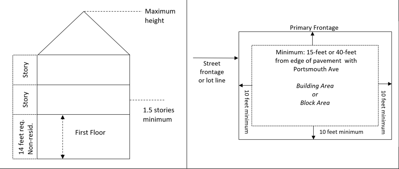
TABLE 3.
| Accessory structures shall be limited to the following: | |
|---|---|
| Type of Use | Dimensional Requirements |
| Commercial, Businesses, and Other Non-Residential Uses | 1.5 stories maximum height 8 feet minimum first story height 400 S.F. maximum footprint |
| Civic, Recreational, Public Facilities or Transportation Uses | No restrictions on dimensional requirements. |
TABLE 4.
| Streetscape Standards | ||
|---|---|---|
| Roadway Type | Right of Way Width | Description |
| Boulevard | 72 feet minimum 94 feet maximum | Two-way traffic flow is required. |
| Avenue | 72 feet minimum 76 feet maximum | One-way traffic flow is permitted. |
| Street (per Regulating Plan) | 51 feet minimum 55 feet maximum | Two-way traffic flow is required. |
| Street (proposed local) | 51 feet minimum 55 feet maximum | One-way traffic flow is permitted; sidewalks required on one side of street. |
| Alley | 12 feet maximum | One-way traffic flow is required. |
TABLE 5.
| Streetscape Elements | ||
|---|---|---|
| Element | Standards | Description |
| Planting Strip | 5-foot minimum width (as shown on roadway cross-sections) | Refer to Site Plan Review Regulations Section 5.2 for landscaping requirements. |
| Setback | Combined 13 feet minimum/20 feet maximum | Composed of sidewalk and planting or street buffer strip with granite curbing. |
| Crossings | 6 feet minimum width, 10 feet maximum width Required at street intersections and permitted at mid-block | Within an individual block or development, shall be composed consistently of similar materials and may include brick, pavers, stamped concrete, porous pavement; all sidewalks shall have granite curbing against a thoroughfare. Differentiate with use of non-asphalt materials, striping and accent paving or materials. |
| Street Trees | 1 per 25¹ linear feet of right-of-way | Located within the Planting Strip or Street Buffer Strip. |
| Lighting | 1 per 25¹ linear feet of right-of-way | Along all sidewalks, New England traditional fixtures with downcast illumination; lighting placement shall alternate with street tree placement. |
| Seating | Encouraged | In public spaces (such as pocket parks and gardens) and at street intersections. |
| Shelters (transit, school bus stops) | Optional | Painted or coated metal frame or natural materials. |
| Trash Receptacles | Required | Secured and covered at street intersections or mid-block. |
| Bicycle Racks | Required | At transit stops/shelters, public spaces, parking areas. |
| Driveway, Sidewalk, and Electric Vehicle Charging Station Standards: | ||
The following standards shall apply to sites in the Gateway Commercial Business District and are supplemental to all requirements of the Site Plan Regulations. The Planning Board shall be empowered to waive any of the following requirements of this Section. For this Section, new development, redevelopment, or significant site improvements shall include any project where more than 2,500 square-feet of new additional interior space is proposed, or any site improvement or redevelopment valued at $500,000 or more. These regulations are enacted in order to support the Town’s efforts to provide for a more pedestrian-friendly environment along the Portsmouth Avenue corridor.
Properties with between 50 and 599 of frontage along Portsmouth Avenue shall be afforded one driveway curb cut on to Portsmouth Avenue. Properties with a minimum of 600-feet of frontage along the Portsmouth Avenue shall be afforded up to two driveway curb cuts provided the curb cut locations are spaced at least 400-feet apart.
No driveway curb cut for a commercial, multi-family residential or mixed-use site shall be sited within 200 linear feet of an existing intersection or driveway curb cut on the same side of the street unless a waiver is granted by the Planning Board. Where a driveway is proposed within 200-feet of a proposed driveway location and a waiver is requested, the applicant shall make reasonable efforts to determine if a shared-use driveway between the properties is feasible before submitting a waiver request.
All non-residential and multi-family development shall be served my driveways having a minimum width of 20-feet and a maximum width of 30-feet. Wider driveways may be permitted if necessary for safe site circulation and Fire Department access. Vehicular turning lanes shall not be counted toward the maximum driveway width.
The angle of entry to new driveways shall be as close as ninety (90) degrees as is practicable.
Sidewalks/Pedestrian Facilities
Electric Vehicle Charging Facilities
Where new development, redevelopment, or significant site improvements are proposed, at least one electric vehicle charging station facility shall be provided for parking lots with at least 20 parking spaces. A minimum of one electric vehicle charging facility shall be provided for every 20 parking spaces proposed.
¹ For trees and lighting located along Portsmouth Ave. (SR 108), the spacing shall be AVG 30’ for trees and AVG 60’ for lighting. The Planning Board shall determine the final number and location of each element based upon review by qualified professionals and in coordination with NHDOT.
TABLE 6.
| Parking Area Design Standards | ||
|---|---|---|
| Element | Standards | Description |
| Medians | Located between opposing parking isles and at periphery. | Shall incorporate for use as a storm water management best management practice, wherever feasible; vegetation shall be appropriate for wet/dry conditions and salt tolerant. |
| Islands | Located at end of parking isles and at entrance/exit. | Used primarily as screening and landscaping areas comprised mostly of trees, shrubs, and groundcovers that are drought and salt tolerant. |
| Placement | Located at rear or side of buildings, and interior of blocks. | |
Figure 1. Zone Roadway Cross-Section
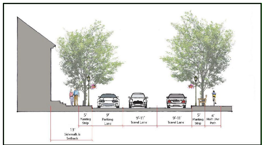
Revised March 2017, March 2023; added March 2023
Revised March 2016
Architectural and Site Design Standards
Building Exterior Features:
Building facades shall be compatible in scale, mass, and form with adjacent structures and the development pattern of the surrounding area (assuming the adjacent structures are generally in compliance with these design standards).
Exterior building design and detail on all elevations shall be coordinated with regard to color, types of materials, number of materials, architectural form, and detailing to achieve harmony and continuity of design.
Paint colors, excluding signage and awnings, shall be limited to a reasonable number and range of palette to achieve consistency of style and character with adjacent development.
Where appropriate, architectural details and richly detailed designs are encouraged to provide variation and creative designs. All features and details should be of a style consistent with the overall design scheme and in proportion with the building and adjacent structures.
Rear and side building walls, if visible from public streets and spaces or neighboring properties, shall be designed with similar detailing and materials and be compatible with the principal façade(s) of the building. All elevations and cross-sections of a building shall be shown on a site plan.
To avoid long unbroken or unadorned wall planes, building facades and walls should not extend beyond 50 – 75 feet without including changes of wall plane that provide strong shadow or visual interest.
Exterior materials shall be durable and of high quality. Excessively vibrant colors, sharply contrasting colors, and highly reflective materials are not compatible with the traditional New England character. All Architectural elements of all facades must be submitted with an application.
Pedestrian level storefronts shall employ non-reflective glass or light gray tinted glass to enhance the visibility of the displayed merchandise from the outside.
All windows and doorways shall be encased with wood or simulated wood trim; decorative trim is preferred. Aluminum windows shall be finished to match the proposed trim color of the building.
True divided light windows and shutters are encouraged. Shutters shall be sized such that when closed they cover the window.
All vents, gutters, downspouts, flashing, electrical conduits, etc., shall be painted to match the color of the adjacent building surface, unless being used expressly as trim or accent element.
Material or color changes generally should occur at a change of plane. Piecemeal embellishment and frequent changes in color or material should be avoided.
The visibility of rooftop equipment shall be minimized by grouping all plumbing vents, ducts, and rooftop mechanical equipment away and screened from public view at ground level. Wall or ground mounted equipment shall be screened fully from public view with walls, fences, or vegetation. No air conditioning, ventilating, or other mechanical or electrical equipment, except for lighting fixtures, may project more than four (4) inches beyond the face of a wall facing a public street or space.
Franchise or corporate style architecture and/or highly contrasting color schemes are strongly discouraged. If used, such buildings shall be designed to create a project that is consistent with traditional New England village character.
Fences in the traditional historic New England style and materials (i.e., picket, split rail, wrought iron, brick, stone) shall be used. Chain link security fences may be allowed only where necessary for safety or security, but their use is generally discouraged.
The following building materials shall be used and combined to create a consistent, attractive, and cohesive building design:
Natural Brick (painted brick is not recommended, as it tends to require frequent maintenance);
Natural Stone (such as, but not limited to, fieldstone, granite, limestone and marble);
Terra cotta and/or cast stone which simulate natural stone);
Split-face Block/Concrete Masonry Unit (CMU) and painted concrete block or panels as appropriate for side and rear elevations;
Natural wood and/or cement-based artificial wood siding; and
Glass
Roof Lines, Styles and Materials:
Sloped roofs are highly preferred. Gabled and hipped roofs should have a slope of greater than 4/12 (18º), but less than 14/12 (49º).
Gambrel and Mansard roofs are acceptable for appropriately sized structures.
Flat roofs are strongly discouraged unless to allow the creation of a “green roof” as a Low Impact Development (LID) technique. Where used, they should have a parapet wall at the façade with cornice elements and facing all thoroughfares.
Site Design:
Traditional New England Village planning principles (“Traditional Neighborhood Design”) are used to create a village center consisting of dense mixed use and commercial areas organized around public spaces and bordering residential neighborhoods.
All roadways shall be designed as a complete street that addresses the needs and safety of all users. Layout shall incorporate landscaping and lighting elements.
Land Use and Housing:
Mixed Uses in the Gateway District shall provide commercial retail stores and shops, food service/bar/entertainment establishments, and professional offices and businesses on the first floor of buildings, with professional office and businesses, light commercial (such as artisanal manufacturing) and residential uses optionally on the upper floors.
Residential neighborhoods should include a mix of housing types, sizes, and styles, and provide public gathering and/or recreational spaces or areas for use by residents, businesses, visitors, and the community.
Developments shall provide a viable mix of residential and non-residential uses to promote living and employment opportunities in the style of a Traditional New England Village.
Landscaping:
Landscaping shall be an integral component of site design to provide visual interest, scenic and aesthetic beauty, maintain natural vegetation and landscape features, and maintain or create greenways throughout the District.
Landscaping shall be integrated with LID practices, general storm water management, and parking lot and roadway designs.
Landscaping should consider use of native species of trees, shrubs, ground cover and flowering plants.
For all development within the Gateway District, a Landscaping Plan shall be prepared and submitted following the requirements of this ordinance and Section 5.2.N of the Site Plan Regulations.
Transportation Network and Access:
New roads, streets, or internal thoroughfares shall connect to the existing transportation network within the District and adjacent zoning districts to provide efficient traffic patterns and site access. Development shall provide potential future connections to adjacent properties and not prevent or preclude these connections.
Open Space and Recreation:
All development in the District is required to provide a percentage of open space. These open spaces shall be located to provide connections between existing open spaces (both within the outside the District), visual interest, scenic vistas and view sheds, diversity in the developed landscape, preserve natural resources and features, provide gathering spaces for community uses, civic uses and outdoor activities.
Existing conservation lands within the District and beyond its periphery provide natural areas for passive recreation by residents, visitors and the public, and provide extensions of the required open space areas within the District.
DEFINITIONS of Terms
This Subsection provides definitions for terms in this Ordinance that are technical in nature or that otherwise may not reflect a common usage of the term.
a. Accessory Structure: An Outbuilding or with an Accessory Use to the Principal Structure.
b. Bicycle Lane: A dedicated lane for cycling within a moderate-speed vehicular Thoroughfare, demarcated by striping.
c. Block: The aggregate of private Lots, Passages, Rear Alleys, and Rear Lanes, circumscribed by Thoroughfares or Streets.
d. Boulevard: A Thoroughfare designed for high vehicular capacity and moderate speed, traversing an urbanized area.
e. Civic: The term defining not-for-profit organizations dedicated to arts, culture, education, recreation, government, transit, and municipal parking.
f. Civic Building: A building operated by not-for-profit organizations dedicated to arts, culture, education, recreation, government, transit, and municipal parking, or for use approved by the legislative body.
g. Civic Space: An outdoor area dedicated for public use. Civic Space types are defined by the combination of certain physical constants including the relationships among their intended use, their size, their landscaping, and adjacent buildings.
h. Curb: The edge of the vehicular pavement or edge of a sidewalk or setback that may be raised or flush, and often incorporates a drainage system.
i. Density: The number of dwelling units within a standard measure of land area.
k. Driveway: A vehicular lane within a Lot for the purpose of providing access from a thoroughfare.
l. Drive-through Service: A business (such as a bank or restaurant) that is designed so that customers can be served while remaining in their vehicles.
Added March 2021
m. Elevation: An exterior wall of a building not along a Frontage Line. See: Facade.
n. Facade: The exterior wall of a building that is set along a Frontage Line. See Elevation.
o. Frontage: The area between a building Facade and the vehicular lanes, inclusive of its built and planted components. Frontage is divided into Private Frontage and Public Frontage.
p. Frontage Line: A lot line bordering a Public Frontage.
q. Greenway: An Open Space Corridor in largely natural conditions or re-established vegetated and/or forested conditions, which may include trails for bicycles and pedestrians.
r. Infill: Noun - New development on land that had been previously developed, including most Greyfield and Brownfield sites and cleared land within urbanized areas. (Verb - to develop such areas.)
s. Lot Width: The length of the Principal Frontage Line of a Lot.
t. Low Impact Development: Low Impact Development (LID) incorporates sustainable land development approaches that begin with a site planning process that first identifies critical natural drainage systems and other landscape hydrologic functions. LID techniques include: maintaining natural drainage flow paths, minimizing land clearance, clustering buildings, and reducing impervious surfaces. A series of small storm water best management practices (BMP’s) that preserve the natural features and hydrology of the land are used instead of the conventional methods of collecting, conveying, and discharging runoff off the site.
v. Office: Premises available for the transaction of general business but excluding retail, artisanal and manufacturing uses.
w. Open Space: Land intended to remain undeveloped.
x. Park: An area of natural, semi-natural, or planned space designated for human enjoyment and/or the protection of wildlife or natural habitats.
Revised March 2021
z. Path: A pedestrian way traversing a Park or rural area, with landscape matching the contiguous Open Space, ideally connecting directly with the Sidewalk network.
bb. Principal Entrance: The main point of access for pedestrians into a building.
cc. Principal Frontage: The Frontage designated to bear the address and Principal Entrance to the building, and the measure of minimum Lot width. See Frontage.
dd. Private Frontage: The privately held Layer between the Frontage Line and the Principal Building Facade.
ee. Public Frontage: The area between the Curb of the vehicular lanes and the Frontage Line.
ff. Public Space: Lands that are dedicated for public use but that are privately owned and maintained which may include squares, plazas, greens, civic spaces, paths, trails, alley, park,
gg. Rear Alley: A vehicular way located to the rear of Lots or Blocks providing access to service areas, parking, and Outbuildings and that may contain utility easements. Rear Alleys should be paved from building face to building face, with drainage by inverted crown at the center or with roll Curbs at the edges.
hh. Rear Lane: A vehicular way located to the rear of Lots providing access to service areas, parking, and Outbuildings and containing utility easements. Rear Lanes may be paved lightly to Driveway standards. The streetscape consists of gravel or landscaped edges, has no raised Curb, and is drained by percolation.
ii. Regulating Plan: A Zoning Map that shows the boundaries of the Gateway Commercial Business District and Zones within it, and other areas subject to or potentially subject to regulation.
jj. Secondary Frontage: On corner Lots, the Private Frontage that is not the Principal Frontage.
kk. Sidewalk: The section of the Public Frontage dedicated exclusively to pedestrian activity.
ll. Square: A Civic Space type designed for unstructured recreation and Civic purposes, spatially defined by building Frontages and consisting of Paths, lawns, and trees, formally disposed.
mm. Story: A habitable level within a building, excluding an attic or raised basement.
nn. Street: A local urban Thoroughfare of low speed and capacity.
oo. Thoroughfare: A way for use by vehicular and pedestrian traffic and to provide access to Lots and Open Spaces, consisting of Vehicular Lanes and the Public Frontage.
pp. Traditional New England Village: Development patterns that are civic-oriented, pedestrian-friendly, economically vibrant, and diverse, environmentally sustainable, and evoke a unique sense of place that emulates the agricultural tradition of Stratham.
§ 3.9Town Center District
Adopted March 2014; revised March 2016, March 2021
Authority:
The action of the Town of Stratham, New Hampshire in the adoption of this Ordinance is authorized under RSA 674:21.II Innovative Land Use Controls and RSA 674:16 Grant of Power.
This Ordinance was adopted to promote the health, safety, and general welfare of the Town of Stratham and its citizens, including protection of the environment, conservation of land, energy and natural resources, reduction in vehicular traffic congestion, more efficient use of public funds, health benefits of a pedestrian environment, preservation of community character, education and recreation, reduction in sprawl development, and improvement of the built environment.
This Section was adopted as one of the instruments of implementation of the public purposes and objectives of the Town’s Master Plan. This Ordinance is declared to be in accord with the Master Plan, as required by RSA 674:2.
Applicability:
This Ordinance shall establish the Town Center District (the “District”). The boundaries of the District are shown on the Official Town Zoning Map (as amended) and the on the map entitled “Town of Stratham, NH, Town Center District Regulating Plan” (the “Town Center Regulating Plan”) dated December 2013 (as amended) and hereby incorporated as part of this ordinance.
The provisions of the Town Center District shall be mandatory for development projects within the District. Development projects submitted for approval under this zoning district shall be subject to applicable requirements of the Subdivision and Site Plan Review Regulations of Stratham.
When in conflict, the provisions of the District shall take precedence over those of other ordinances, regulations, and standards except the Local Health and Safety Ordinances and Building Codes.
Section 3.8.10 Definitions of Terms contains regulatory language that is integral to the District. Those terms not defined in Section 3.8.10 or in Section II of the Zoning Ordinance shall be accorded their commonly accepted meanings. In the event of conflicts between definitions in the Zoning Ordinance and the District, those of the District shall take precedence.
The requirements of Section 3.9.8 Development Standards and Tables are an integral part of the District and are legally binding. Unless otherwise noted, other diagrams and illustrations that accompany this ordinance are provided for guidance purposes and as recommended examples.
If in conflict, numerical requirements shall take precedence over graphic illustrations.
Purpose and Intent:
To provide a traditional pattern of development that supports a diverse range of uses, public spaces, and walkable streets culminating in an integrated rural New England town center and civic focal point.
To promote traditional small town center building and site development patterns with an interconnected pattern of streets, alleys, and lanes, which provides for safe and efficient vehicular and pedestrian travel at a scale consistent with the small, rural town center setting, and which provides for the connection of those streets to existing and future developments.
To protect environmental resources, preserve and protect scenic vistas, historic and archeological buildings and sites, conservation and agricultural areas, and unique natural features of the landscape and district.
To enhance the economic vitality and business diversity. Create a critical mass of businesses and activity in the Town Center that further establishes the area as a focal point provide a unique shopping, service-based businesses, recreational, and cultural experience in the region.
To provide for pedestrian and bicycle travel throughout the development through the creation of sidewalks, paths, and bicycle paths.
To promote the use of neighborhood greens, pocket parks, landscaped streets, and access to green space to provide space for recreation and social activity, and to provide visual enjoyment.
To preserve and enhance the rural, small town character of New England towns through architectural and streetscape design that replicates in scale and character the best examples of traditional neighborhood design from the historic towns and villages of New England and to create and clearly delineate public and private spaces to enhance the quality of life and aesthetic quality of both the residents of the development and the town as a whole.
To provide a mix of housing styles, types, and sizes, to accommodate households of all ages, sizes, and incomes.
To provide buildings and spaces for civic assembly and neighborhood activities that promote the development of social networks and community and provide a visual focal point for the village subdivision.
Development in the Town Center District shall incorporate the following:
Wherever possible natural infrastructure and visual character derived from topography, woodlands, farmlands, riparian corridors, and other environmental features shall be retained;
Adaptive reuse, infill development and redevelopment shall be encouraged. New construction should reinforce the historic significance of the District and be compatible with the context of the existing historically significant structures identified in the Regulating Plan;
Development contiguous to adjacent zoning districts shall be organized to complement and be compatible with the existing pattern of development and the natural landscape;
Network of existing and proposed streets shall be designed for access to Portsmouth Avenue, College Road, Winnicutt Road, and local connector roads, disperse traffic to and from the District, and reduce traffic volumes;
Transportation corridors shall be planned and reserved in coordination with proposed land uses;
Greenways shall be used to define and connect developed areas and provide public spaces and enhance view sheds to adjacent conservation lands;
Development shall integrate a framework of transit, pedestrian, and bicycle systems that provide accessible alternatives to the automobile;
Use of on-street parking shall be allowed;
Architectural and landscape design suited to a traditional New England rural and village appearance shall be applied; and
Public gathering and public use spaces shall be established and connections made throughout the District in a manner and location that will encourage use and promote safety and security.
The Regulating Plan:
The purpose of this Ordinance is to enable, encourage, and implement the following plans and general requirements.
For the purposes of the delineation, the Town Center District and the location and boundaries are hereby established as shown on the Official Town Zoning Map (as amended) and the on the map entitled “Town of Stratham, NH, Town Center District Regulating Plan” (the “Town Center Regulating Plan”) dated December 2013 (as amended) and hereby incorporated as part of this ordinance.
District Character:
Development in the Town Center District should incorporate the following concepts to preserve and complement elements of the historic character of Stratham Town Center:
Provide for a traditional pattern of development that supports a diverse range of uses, public spaces, and walkable streets culminating in an integrated town center and civic focal point.
Mixed-use pattern of development where development specializing in a single use should be the exception;
Where ordinary activities of daily living should be located within walking distance of residential areas, allowing independence to those who do not drive;
Within mixed use and residential developments, a range of housing types and price levels shall be provided to accommodate diverse ages and incomes; Workforce housing is encouraged within the District to promote a diversity of housing choices;
A range of open space including pocket parks, squares, and playgrounds shall be distributed within neighborhoods and throughout the District;
Preservation and enhancement of historically and architecturally significant structures, landmarks, and archeological sites as identified in the Regulating Plan;
Expansion and provision of public transportation facilities that promote use and access is encouraged;
Provide improved visibility and access to and use of conservation lands, where appropriate; and
Provide opportunities for agriculture and agritourism, as defined in Section II, Definitions, 2.1.6.
Revised March 2016
Revised March 2016
Review and Permitting Process:
The Planning Board shall have the authority to grant or deny a request for a Conditional Use Permit, pursuant to the provisions of RSA 674:16 and RSA 674:21. A Conditional Use Permit, for relief from the requirements of this Ordinance, after proper public notice and public hearing where the Planning Board finds that an application complies with standards (a) and (b) below.
Consistent with the Gateway Business District Master Plan, including but not limited to:
Both public and private buildings and landscaping shall contribute to the physical definition of streetscapes and public spaces; and
Development shall adequately accommodate automobiles and emergency vehicles, while respecting the pedestrian and the spatial form of public spaces; and
Design of streets and buildings shall reinforce safe environments, but not at the expense of accessibility and efficient traffic flow; and
Architecture and landscape design shall complement climate, topography, community character, and building practice; and
Open space and public gathering places shall be provided as locations that reinforce the identity and activity of the District and the community; and
New development and redevelopment shall be otherwise consistent with the intent and purpose of this ordinance; and
Does not unduly impact adjacent properties and uses in the District.
Improves public safety within the District and/or in adjacent zoning districts; or provides environmental and natural resource protection; or provides a measurable public benefit (such as increased public space, open space, or public amenities).
The granting or denial of a Conditional Use Permit by the Planning Board may be appealed to the Superior Court, as provided for in RSA 677:15. A Planning Board decision on the issuance of a Conditional Use Permit cannot be appealed to the Zoning Board of Adjustment (RSA 676:5 iii).
Revised March 2021
Building and Site Design Standards:
Purpose:
In order to provide for harmonious and aesthetically pleasing development in the built environment [RSA 674:44,II(b)], the Planning Board will apply the following Building and Site Design Standards in its review of all applications in the District.
Intent:
Maintaining the quality and character of the Town Center is dependent upon the quality and character of the architecture and development that is allowed to occur. Poorly planned and executed development detracts from the character and function of the built environment, while well-planned development enhances community character, quality of life, and value of the surrounding properties and the community overall.
Design standards are a tool to help guide development and redevelopment assuring that community priorities are an integral part of the design process. Design Standards, implemented as part of the application review and approval process, are a set of design principles that offer a positive direction for building and site level design. The guidelines and interpretations are based upon maintaining and enhancing the character of the Town Center.
Design Standards address a wide range of design issues including such elements as: pedestrian and traffic circulation, building mass and scale, architectural details and building materials, signs, landscaping, lighting, open space, and natural features. When integrated, these elements will create a project that is functional, attractive, and an asset to the community.
Building and Site Design Evaluation:
The evaluation of the following factors will inform the Technical Review Committee and the Planning Board’s decisions on whether proposed site and building designs achieve the purpose and intent of these Design Standards and of this Ordinance. The Planning Board shall develop a Town Center District guidance document to further illustrate and provide details of the design standards stated below. This document shall be utilized by applicants when designing projects within the District.
The Town Center District shall be designed in a pattern of interconnecting streets and alleys, defined by buildings, street furniture, landscaping, pedestrian ways, and sidewalks. The layout should be suited to the existing topography and other natural and/or historic features of the area.
Within a development project, site design elements should be compatible with a traditional New England Village character and the Town Center’s heritage and historic function within the community.
Building architecture should demonstrate the cohesive planning of the development and present a clearly identifiable, attractive design feature and appearance throughout. It is not intended that buildings be totally uniform in appearance or that designers and developers be restricted in their creativity. Rather, cohesion and identity can be demonstrated in harmonious building style, scale, or mass; consistent use of facade materials; similar ground level detailing, color, or signage; consistency in functional systems such as roadway or pedestrian way surfaces, signage, or landscaping; public amenities; the framing of outdoor open space and linkages, or a clear conveyance in the importance of various buildings and features on the site.
Building architecture should be designed to provide an attractive appearance. Franchise or corporate style architecture and/or highly contrasting color schemes are strongly discouraged. If proposed, such building styles should be substantially modified to create a project that complements the traditional New England Village character. All architectural details should be related to an overall architectural design approach or theme.
Diversity of architectural design, massing, scale, context, and fenestration is encouraged. Buildings that are characteristic of a historic period are encouraged, particularly if a building style or the site is historically appropriate for the Town Center or necessary for architectural harmony.
The historic character of buildings/structures will be retained and preserved. The removal of distinctive materials or alteration of features will be avoided. Further, new additions, exterior alterations, or related new construction will not destroy historic materials, features, and spatial relationships that characterize historically significant structures. The new work shall be differentiated from the old and will be compatible with the historic materials, features, size, scale and proportion, and massing to protect the integrity of the property and its environment.
Multiple buildings on the same site and attached buildings should be designed to create a cohesive visual relationship, as well as efficient circulation and access for pedestrians and vehicles. Accessory buildings should be designed to complement the primary building and/or use on the site in design and material expression.
Building placement should take best advantage of solar orientation, climatic and other environmental conditions, should encourage safety and use of adjacent public spaces and public open spaces, and should minimize the impact of activity and light upon and from the project.
Buildings adjacent to public open space should generally be oriented to that space, with access to the building opening onto the public open space.
Implementation of Low Impact Development techniques is strongly encouraged, including, but not limited to, storm water management practices, alternative surfacing materials, building and site design elements, and landscaping features.
The practice of creating structures and using processes that are environmentally responsible and resource-efficient throughout a building's life-cycle from siting to design, construction, operation, maintenance, renovation, and deconstruction are strongly encouraged.
All electrical utilities shall be located underground.
Street and Streetscape Standards:
Streets shall be laid out in a grid-like pattern to increase the access to and depth of the district and to define blocks.
Streets shall provide the following streetscape elements: sidewalks, pedestrian crossings, planting strips, street trees, and lighting. Bike lanes are encouraged on streets shown on the Regulating Plan and as detailed in Section 3.9.8 Figures 1 and 2. See Section 3.9.8 Table 6 for additional standards for required and recommended streetscape elements.
Streets that incorporate commons and squares are encouraged to provide public parks and spaces and add visual form and interest to the development. Roundabouts may also be incorporated when necessary to enhance traffic flow and safety.
Other new streets s shall be aligned as closely as possible at right angles to the roadway network shown on the Regulating Plan and spaced according to the needs of the development serviced, traffic demand and safety.
Sidewalks. All developments shall provide or contribute to the development and construction of sidewalks to serve the development site. The width of the sidewalk shall be consistent with the prevailing pattern in the immediate neighborhood, provided that no new sidewalk shall be less than six feet wide. Crosswalks shall be clearly marked with diagonal-striped paint and electronic signals where applicable. Where feasible, crosswalks should be constructed of a contrasting material to the street surface, such as brick.
Each non-residential or mixed-use development is strongly encouraged to contain one or more public spaces. These spaces should be designed to encourage community interaction and may include but are not limited to playgrounds, bandstands, picnic areas, central greens, open plazas with appropriate street furniture, or gardens with pedestrian access and seating. The overall dimensions of the public spaces may vary depending on existing site conditions and individual site designs.
Landscaping Standards:
The following landscaping standards shall apply to all development:
Following are requirements for implementation of buffers:
A minimum 20-foot vegetated buffer shall be provided between proposed development and adjacent residential zoning districts outside the Town Center District.
Buffers shall be established or maintained at a density that attenuates year-round the impact of activity and light on adjacent properties.
Use of native species of trees, shrubs, groundcover, and decorative plants in all landscaping is strongly encouraged.
A landscaping plan, including a maintenance plan and agreement, shall be approved as part of the review and approval process as stated in the Site Plan Review (Section 5.2) and Subdivision Regulations.
Lighting Standards:
Street, building, and site lighting shall not adversely impact surrounding uses and residential projects, and be designed with no light spilling or reflecting into adjacent properties and with protection of the night sky. Such lighting shall not blink, flash, oscillate, or be of unusually high intensity of brightness, except for purposes of providing emergency services or to protect public safety.
Energy-efficient exterior lighting and streetlights shall be provided.
Lighting of the site shall be adequate at ground level for the protection and safety of the public in regard to pedestrian access and vehicular circulation. This shall include, but not be limited to sidewalks, crossings, parking areas, and other public spaces.
Street lighting shall be consistent throughout the district and in accordance with the design established by the Town.
Refer to additional lighting requirements in Section 3.9.8, Table 6.
Unless otherwise stated, lighting shall comply with the standards of the Site Plan Review Regulations, Section 5.8.
Parking Standards:
On-street parking shall provide short-term parking for patrons of shops and businesses. On street parking to service residential areas is recommended.
Parking for mixed use developments shall provide long-term and shared parking by multiple uses and users.
Delivery and other service-related areas for mixed use and non-residential uses can be located at the front, rear, or sides of buildings, or within designated portions of parking areas. Loading docks and service areas shall not face a public frontage. Delivery and service vehicles are encouraged to utilize rear alleys for building access.
Refer to additional parking requirements in Section 3.9.8, Table 7.
Parking in the District shall comply with the requirements of Section 5.9 of the Site Plan Regulations.
Pedestrian and Bicycle Access:
Direct pedestrian and bicycle connections between mixed-use development and residential areas are required. Such connections include connections between sidewalks and walking paths, connections between bike paths in the residential area and the mixed-use development, connections from residential areas to parking areas within the District, and connections to adjacent neighborhoods that have sidewalks or paths. In all cases, bicycles shall not be allowed on, and a clear delineation shall be made between bicycle paths and sidewalks through appropriate signage. In the residential areas and in paths within the conservation area and recreational trails, bicycles and pedestrians may share the same path. In winter months, designated sidewalks and pedestrian/bicycle paths shall be cleared of snow and ice except in conservation and recreational trail areas, where paths may be used for winter recreation to include cross country skiing and snowshoeing. Where feasible, bicycle and pedestrian access shall be provided to existing bus stops, or other mass transit.
Development Standards and Tables
Permitted Uses
| Type of Use | Town Center District |
|---|---|
| Agriculture and Forestry | Permitted Includes crop production; customary accessory uses; forestry (tree farming, commercial timbering, non-commercial harvesting of forest products); community gardening. |
| Civic/ Institutional | Permitted Includes schools, nursery through college schools; day care facilities; senior citizen and community centers; outpatient clinics and treatment facilities; non-profit lodges and fraternal organizations; place of worship including customary ancillary facilities; public utilities; and municipal buildings. |
| Commercial | Permitted Includes retail sales and service; personal and commercial services; professional office; banking and lending institutions; food service/bar/entertainment; special promotional sales and displays; conference centers, movie and performance theatres, indoor entertainment complex. |
| Drive-through Service | By Conditional Use Permit |
| Food Service/Bar/Entertainment¹ | By Conditional Use Permit |
| Mixed Use² | Permitted |
| Open Space/Conservation | See #3 |
| Residential – single-family, two-family | Permitted Includes single-family (1 unit), Two-family (2 units), workforce housing, manufactured housing, home occupations, accessory dwelling units. |
| Residential – multi-family and other residential uses | Permitted Includes multi-family (3-8 units), workforce housing, manufactured housing; home occupations; accessory dwelling units; bed and breakfast inns, hotels, motels, hostels; and open space cluster developments. |
| Recreational | Permitted Includes forestry, wildlife, timber preserves, reservoirs; public parks and playgrounds; natural resource management and research. |
| Other Uses not listed | By Conditional Use Permit |
1 Food Service/Bar/Entertainment includes all food service and entertainment related uses such as restaurants, dinner theatres, bars, pubs, cafes, and coffee shop/diners, permitted mobile food vendors, and farm stands.
2 Mixed-Uses includes Residential and Commercial and/or Professional Business uses in combination in one or several structures; non-residential use shall comprise >50% of the gross floor area.
3 Uses may be permitted according to the terms and restrictions of any open space designated on a specific property.
Town Center District Design Standards and Roadways
TABLE 1.
| Dimensional Requirements | ||
|---|---|---|
| Footprint, Block or Lot | Area | Description |
| Single Family (1 unit) Two-Family (2 units) | 15,000 S.F. minimum lot | Minimum area dependent on Soil-Based Lot Sizing* |
| Multi-Family (3-8 units) | 8,000 S.F. maximum building footprint 15,000 S.F. minimum lot | Minimum area dependent on Soil-Based Lot Sizing* |
| Building Footprint (non-residential and mixed use) | 10,000 S.F. maximum footprint 15,000 S.F. minimum lot | Minimum area dependent on Soil-Based Lot Sizing* |
| Residential, Mixed Use, and Non-Residential | 40,000 S.F. maximum block size | Block with frontage on no less than two sides; Minimum area dependent on Soil-Based Lot Sizing* |
| * Unless innovative sewage treatment facilities are proposed or public water and wastewater services are available, all developments shall meet the standards set forth in the Stratham Subdivision Regulations Section 4.3 Soil-Based Lot Size Determination (as amended). | ||
| Frontage Buildout | 70% maximum | Includes Principal and Accessory Structures |
TABLE 2.
| Building Height | |||
|---|---|---|---|
| Principal Structure (non-residential, mixed use, and multi-family) | 2.5 stories maximum 35 feet maximum height 14 feet minimum required for non-residential | Principal Structure (single-family and two-family) | 2.0 stories maximum |
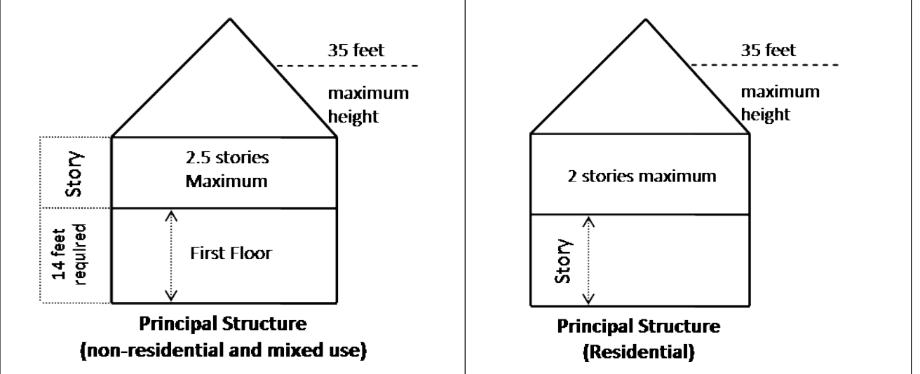
TABLE 3.
| Setbacks – Principal Structures | |||
|---|---|---|---|
| Principal Structure (non-residential, mixed use) | Principal Structure (single-family, two-family, multi-family) | ||
| Frontage | 0 feet minimum/25 feet maximum | Frontage | 8 feet minimum/25 feet maximum |
| Side | 25 feet minimum 0 feet if secondary frontage | Side | 10 feet minimum |
| Rear | 10 feet minimum 0 feet if secondary frontage | Rear | 10 feet minimum |
| Note: individual buildings on a lot or block may be connected, with no separation between or setback from one another. | |||
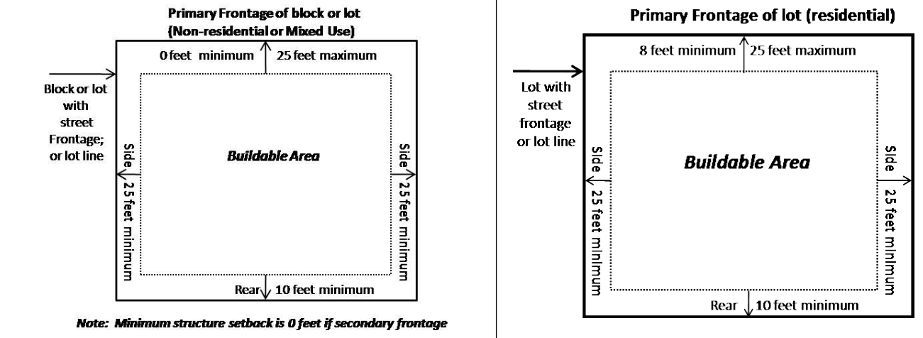
TABLE 4.
| Setbacks – Accessory Structures | |
|---|---|
| Type of Use | Dimensional Requirements |
| Commercial, Businesses and Other Non-Residential Uses | 2 stories maximum height 8 feet minimum first story height 400 S.F. maximum footprint |
| Residential Uses | 2 stories maximum height 8 feet minimum first story height 400 S.F. maximum footprint Shall be setback behind the front building wall of principal structure (see diagram below. |
| Civic, Recreational, Public Facilities or Transportation Uses | No restrictions on dimensional requirements. |
| Description | |
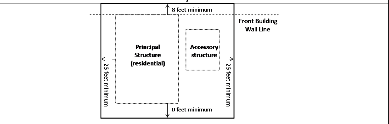
TABLE 5.
| Town Center District Streetscape Standards | ||
|---|---|---|
| Roadway Type | Right-of-way Width | Description |
| Street (proposed local) | 50 feet minimum 54 feet maximum | Two-way traffic flow is required; sidewalks required on one side of street. |
| Street (proposed local) | 36 feet minimum 38 feet maximum | One-way traffic flow is required; sidewalks required on one side of street. |
| Alley | 12 feet maximum | One-way traffic flow is required. |
TABLE 6.
| Streetscape Elements | ||
|---|---|---|
| Element | Standards | Description |
| Planting Strip | 5-foot minimum width (as shown on roadway cross-sections) | Refer to Site Plan Review Regulations Section 5.2. for landscaping requirements. |
| Setback | Combined 14 foot min, 20 foot max | Composed of sidewalk and planting strip or street buffer strip with granite curbing. |
| Crossings | 6 foot minimum width, 10 foot maximum width Required a “t” street intersections and permitted at mid-block | Within an individual block or development, shall be composed consistently of similar materials and may include brick, pavers, stamped concrete, porous pavement; all sidewalks shall have granite curbing against a thoroughfare; sidewalks recommended on both sides of street (except when serving only residential development). Differentiate with use of non-asphalt materials, striping and accent paving or materials. |
| Street Trees | 1 per 25 linear feet | Refer to Site Plan Review Regulations Section 5.2.; street tree placement shall alternate with lighting placement. |
| Street Lighting | 1 per 25 linear feet of right-of-way | Along all sidewalks, New England traditional fixtures with downcast illumination in accordance with the design established by the Town; lighting placement shall alternate with street tree placement. |
| Seating | Encouraged | At public spaces (such as pocket parks and gardens) and at street intersections. |
| Shelters | 1,000 linear feet of right-Of-way | Painted or coated metal frame or natural materials. |
| Trash Receptacles | Optional | Secured and covered at street intersections or mid-block. |
| Bicycle Racks | Required | At transit stops/shelters, public spaces, public parking areas. |
TABLE 7.
| Parking Area Design Standards | ||
|---|---|---|
| Element | Standards | Description |
| Medians | Located between opposing parking isles and at periphery | Shall incorporate for use as a storm water management best management practice, wherever feasible; vegetation shall be appropriate for wet/dry conditions and salt tolerant. |
| Islands | Located at end of parking isles and at entrance/exit | Used primarily as screening and landscaping areas comprised mostly of trees, shrubs and groundcovers that are drought and salt tolerant. |
| Placement | Located at rear or side of buildings, and interior of blocks | |
TABLE 8.
| Public and Open Space Standards | |
|---|---|
| Public Space | Developments shall include a minimum of 15 percent of the total area dedicated to public spaces. Public space calculations shall not include lands within required thoroughfare cross-sections and other proposed streets. Public space shall include facilities and landscapes that promote outdoor activities and enjoyment. |
| Open Space | Developments of .49 acre or less shall include a minimum of 10 percent of the total area dedicated to open space. Developments of .5 acre or greater shall include a minimum of 15 percent of the total area dedicated to open space. Open space shall be contiguous and not include lands within required thoroughfare cross-sections and other proposed streets. Open space requirement can be transferred elsewhere within the Town Center District by designating the minimum open space requirement on another property. Open Space may include septic reserve areas, well protection areas, and LID storm water management features (i.e. natural areas such as bio retention areas, vegetated buffers and rain gardens). Open space shall consist of natural areas, or created natural areas such as gardens, landscaped areas and parks, where the public may gather, recreate and enjoy scenic and/or historic views. |
| Greenway Trail (optional) | Developments may provide a Greenway Trail through the property with connections provided to trails on adjacent properties or open space areas. Greenway Trails shall be a minimum of 8 feet in width and surfaced to provide universal access. |
FIGURE 1. Town Center District Roadway Cross-Sections
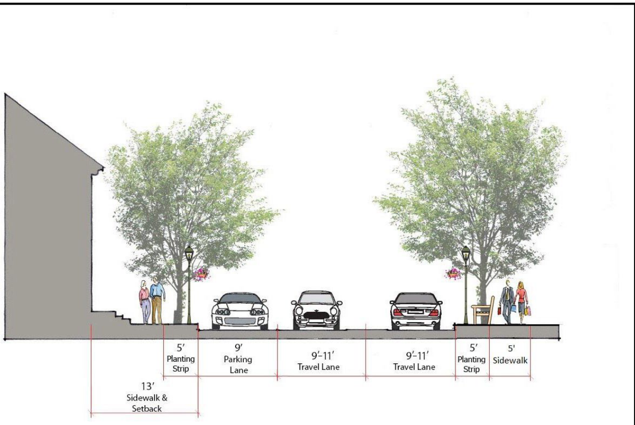
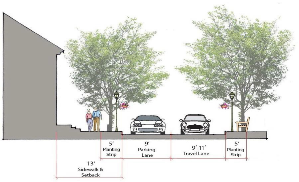
Architectural and Site Design Standards
Building Exterior Features:
Building facades shall be compatible in scale, mass, and form with adjacent structures and the development pattern of the surrounding area (assuming the adjacent structures are generally in compliance with these design standards).
Exterior building design and detail on all elevations shall be coordinated with regard to color, types of materials, number of materials, architectural form, and detailing to achieve harmony and continuity of design.
Paint colors, excluding signage and awnings, shall be limited to a reasonable number and range of palette to achieve consistency of style and character historically significant structures and with adjacent development.
Where appropriate, architectural details and richly detailed designs are encouraged to provide variation and creative designs. All features and details should be of a style consistent with the overall design scheme and in proportion with the building and historically significant structures.
Rear and side building walls, if visible from public streets and spaces or neighboring properties, shall be designed with similar detailing and materials and be compatible with the principal facade(s) of the building. All elevations and cross- sections of a building shall be shown on a site plan.
To avoid long unbroken or unadorned wall planes, building facades and walls should not extend beyond 50 feet without including changes of wall plane that provide strong shadow or visual interest.
Exterior materials shall be durable and of high quality. Excessively vibrant colors, sharply contrasting colors, and highly reflective materials are not compatible with the traditional New England Village character. Architectural elements visible to the public, but not detailed on the plans shall be finished in a material compatible with other exterior colors and materials.
Pedestrian level storefronts shall employ non-reflective glass or light gray tinted glass to enhance the visibility of the displayed merchandise from the outside.
Window and door openings on the front façade shall occupy a total of no less than 20% and no more than 70% of the gross square footage of that facade. The size and placement of windows should be commensurate with architectural style of the buildings and landscape elements in the development.
All windows and doorways shall be encased with wood or simulated wood trim; decorative trim is preferred. Aluminum windows shall be finished to match the proposed trim color of the building.
True divided light windows and shutters are encouraged. Shutters shall be sized such that when closed they cover the window.
All vents, gutters, downspouts, flashing, electrical conduits, etc., shall be painted to match the color of the adjacent building surface, unless being used expressly as trim or accent element.
Material or color changes generally should occur at a change of plane. Piecemeal embellishment and frequent changes in color or material should be avoided.
The visibility of rooftop equipment shall be minimized by grouping all plumbing vents, ducts, and rooftop mechanical equipment away and screened from public view at ground level. Wall or ground mounted equipment shall be screened fully from public view with walls, fences, or vegetation. No air conditioning, ventilating, or other mechanical or electrical equipment, except for lighting fixtures, may project more than four (4) inches beyond the face of a wall facing a public street or space.
Franchise or corporate style architecture and/or highly contrasting color schemes are strongly discouraged. If used, such buildings shall be designed to create a project that is consistent with traditional New England Village character.
Fences in the traditional historic New England Village style and materials (i.e., picket, split rail, wrought iron, brick, stone) shall be used. Chain link security fences may be allowed only where necessary for safety or security, but their use is not permitted.
The following building materials shall be used and combined to create a consistent, attractive, and cohesive building design:
Natural wood and/or cement-based artificial wood siding.
Glass.
Natural Brick (painted brick is not recommended, as it tends to require frequent maintenance).
Natural Stone (such as, but not limited to, fieldstone, granite, limestone, and marble).
Roof Lines, Styles and Materials:
Sloped roofs are required. Gabled and hipped roofs should have a slope of greater than 4/12 (18º), but less than 14/12 (49º).
Gambrel and Mansard roofs are acceptable for appropriately sized structures and access streets.
Standing seam, copper roofing, asphalt, and slate shingles are preferred. Photovoltaic (PV) panel roof materials, which “simulate” traditional roofing materials, are acceptable. Metal roofs that face the street are discouraged, unless architecturally blended with the facade.
Flat roofs are not allowed.
Site Design:
Traditional New England Village planning principles (“Traditional Neighborhood Design”) are used to create a town center consisting of mixed use and commercial areas organized around public spaces and bordering residential neighborhoods.
All roadways shall provide a pedestrian and bicycle friendly layout and incorporate landscaping and lighting elements.
Land Use and Housing:
Mixed Uses in the Town Center District shall provide commercial retail stores and shops, food service/bar/entertainment establishments, and professional offices and businesses on the first floor of buildings, with professional office and businesses, and residential uses optionally on the upper floors.
Residential neighborhoods should include a mix of housing types, sizes, and styles, and provide public gathering and/or recreational spaces or areas for use by residents, businesses, visitors and the community.
Developments shall provide a viable mix of residential and non-residential uses to promote living and employment opportunities in the style of a Traditional New England village.
Landscaping:
Landscaping shall be an integral component of site design to provide visual interest. Wherever possible, preserve desirable natural vegetation and landscape features, and maintain or create greenways throughout the District.
Revised March 2021
Landscaping shall be integrated with LID practices, general storm water management, and parking lot and roadway designs.
Landscaping should consider use of native species of trees, shrubs, ground cover and flowering plants. For all development within the Town Center District, a Landscaping Plan shall be prepared and submitted following the requirements of this ordinance and Section 5.2.N of the Site Plan Regulations.
Transportation Network and Access:
The District shall incorporate a grid-pattern, Streets, loop roads, squares, access roads, and alleys, around open spaces or public spaces.
The Town Center District shall incorporate grids of local and neighborhood streets.
New roads and streets shall connect to the existing transportation network within the District and adjacent zoning districts to provide efficient traffic patterns and site access, and provide for public safety. Development shall provide potential future connections to adjacent properties and not prevent or preclude these connections.
Open Space and Recreation:
All development in the District is required to provide a percentage of open space. These open spaces shall be located to provide connections between existing open spaces (both within the outside the District), visual interest, scenic vistas and view sheds, diversity in the developed landscape, preserve natural resources and features, provide gathering spaces for community uses, civic uses and outdoor activities.
Existing conservation lands within the District and beyond its periphery provide natural areas for passive recreation by residents, visitors and the public, and provide extensions of the required open space areas within the District.
Definitions of Terms
Please refer to Section 3.8.10 for definitions and terms in the Section.
§ 3.10Route 33 Legacy Highway Heritage District
Adopted March 2022
Authority:
The action of the Town of Stratham, New Hampshire in the adoption of this Ordinance is authorized under RSA 674:21.II Innovative Land Use Controls and RSA 674:16 Grant of Power.
This Ordinance was adopted to promote the health, safety, and general welfare of the Town of Stratham and its citizens, including protection of the environment, conservation of land, energy and natural resources, reduction in vehicular traffic congestion, more efficient use of public funds, health benefits of a pedestrian environment, preservation of community character, education and recreation, reduction in sprawl development, and improvement of the built environment.
This Section was adopted as one of the instruments of implementation of the public purposes and objectives of the Town’s Master Plan. This Ordinance is declared to be in accord with the Master Plan, as required by RSA 674:2.
Applicability:
This Ordinance shall establish the Route 33 Legacy Highway Heritage District (the “Heritage District”). The boundaries of the Heritage District, which includes properties with frontages along the NH Route 33 corridor from the Town Center District to the Greenland town line, are shown on the Official Town Zoning Map (as amended) entitled “Zoning Map, Town of Stratham, NH”, and hereby incorporated as part of this ordinance.
The provisions of the Heritage District shall be mandatory for development projects within the Heritage District as stipulated under Section 3.10.5 Activities Subject to Review. Development projects submitted for approval under this zoning district shall be subject to applicable requirements of the Subdivision and Site Plan Review Regulations of Stratham.
When in conflict, the provisions of the Heritage District shall take precedence over those of other ordinances, regulations, and standards except the Local Health and Safety Ordinances and Building Codes.
The requirements of Section 3.10.6 Site Design Standards and 3.10.7 Standards for signage are an integral part of the Heritage District and are legally binding. Unless otherwise noted, other diagrams and illustrations that accompany this ordinance are provided for guidance purposes and as recommended examples.
Revised March 2026
Any land use application that requires site plan approval or subdivision approval, and includes one or more historic structures on the property, shall be required to cooperate with the Heritage Commission to complete a State of New Hampshire Inventory Form for the historic resource(s) present. For purposes of this requirement, a structure is presumed to be historic if it is over 100 square feet in area and is at least 50 years old.
Added March 2026
If in conflict, numerical requirements shall take precedence over graphic illustrations.
Purpose and Intent:
To recognize and preserve the uniquely historic character of the Portsmouth Avenue/Route 33 corridor, and to encourage the adaptive re-use of structures in a manner compatible with that character.
To maintain and enhance the existing and surrounding neighborhood’s residential and agricultural character while providing additional opportunities for Stratham-based entrepreneurs and appropriately-sized small businesses to enter the marketplace, including home-based businesses or home occupations.
To foster greater private investment along the Portsmouth Avenue/Route 33 corridor, particularly in the nearly three dozen historically significant properties identified.
To preserve existing agricultural uses and to encourage new ones that are central to Stratham’s existing character and to provide new venues for the creation of locally-produced goods, foods, and services.
To promote mixed-use development while maintaining a buffer to adjoining residential neighborhoods and protecting the historic fabric of the highway including structures, landscapes, features, and overall character.
To provide for pedestrian and bicycle travel through the creation of sidewalks, paths, and bicycle paths where appropriate.
To provide additional opportunities for residents of Stratham to engage socially, to allow additional venues for community discussions, for artistic expression, and to showcase the cultural and performing arts.
To incentivize the creation of a greater diversity of housing types, styles, and sizes that are more accessible to community members of all ages and income levels.
Heritage District Advisory Committee
A Neighborhood Heritage District Advisory Committee, hereafter referred to as the Advisory Committee, shall be formed within 120 days of the adoption of the Route 33 Legacy Highway Heritage District for the purpose of reviewing and providing comments to the Planning Board for final decisions of applications. The Committee shall consist of the following members:
One appointee of the Planning Board
One appointee of the Heritage Commission
One appointee of the Stratham Select Board
In making appointments to the Advisory Committee, reasonable efforts shall be made to stagger the terms of appointees and to appoint at least one member who lives in or owns property within the Heritage District.
An appointee to the Advisory Committee may or may not be a member of the body they are appointed by. Terms of Advisory Committee members shall be for three years, unless the appointee is a member of the body they are appointed by in which case the length of the term shall coincide with their term on the respective Board or Commission.
Members of the Advisory Committee shall appoint a Chairperson and Vice Chairperson on an annual basis.
The Advisory Committee, in consultation with the Planning Board and Planning Department, shall publish a list of meeting dates and deadlines annually. The Advisory Committee shall set at least one application deadline in every month of the calendar year. The Advisory Committee may amend any meeting date so long as adequate public notice is provided consistent with state law. All meetings of the Advisory Committee shall be public meetings.
The Advisory Committee shall be empowered to carry out the following activities:
Establish Rules of Procedure, in accordance with RSA 671:1.
Adopt guidelines, guidance documents or similar materials to assist applicants, the Advisory Committee, and the Planning Board in the composition, review, and efficient processing of Heritage District applications.
Advise the Planning Board to guide decision-making on all Heritage District applications, through the submission of written recommendations and comments, including on, but not limited to, the following matters:
To provide recommendations related to site design and architectural characteristics of applications.
To provide recommendations related to requested waivers when applicable under these regulations.
To advise the Planning Board, when applicable, if an application meets the Conditional Use Permit criteria required under the Zoning Ordinance.
To recommend final action on applications, including approval, denial, or conditional approval of applications. The Advisory Committee may provide recommended language for conditions of approval.
Comments provided by the Advisory Committee shall be advisory in nature and the Planning Board shall not be bound by such comments. The Planning Board shall make all final decisions on applications.
When infrastructure improvements are planned to the Portsmouth Avenue/Route 33 corridor by the Town or the NH Department of Transportation, the Advisory Committee may provide comments to guide the design and/or implementation of such improvements. Additionally, the Committee may publish recommended roadway design and/or cross-sections to help guide planning, design, or engineering of improvements to public transportation infrastructure.
The Advisory Committee may participate in any public planning or design processes directly affecting the Portsmouth Avenue/Route 33 corridor.
Activities Subject to and Exempt from Review
The following construction activities occurring within the Heritage District shall be subject to review by the Advisory Committee and final decision by the Stratham Planning Board:
The demolition, partial demolition, or removal of any structure that is over 100 square-feet in area and that is at least 50 years old.
The construction of new structures, including accessory structures over 100 square-feet in area, or the addition to an existing structure. Construction activities may be exempt from review if they meet the requirements of Section 3.10.5.b.3.
Any activity which requires Site Plan Review as stipulated in the Stratham Site Plan Regulations.
Site work that increases the amount of impervious surface coverage on a parcel by more than 2,500 square-feet.
New or replacement permanent signage unless it meets all requirements of Section 3.10.7.b of this Ordinance.
The removal or clear cutting of existing vegetation more than 12,000 square-feet in area.
The replacement of siding or roofing materials if the replacement material is of a different material unless the replacement material meets the requirements of Section 3.10.5.b.v.
The siting of ground-mounted solar energy facilities shall be subject to review and approval unless such facilities meet the criteria outlined below, in which case such facilities shall be exempt from review and approval.
Views of the solar facilities must be screened from the public right-of-way.
The solar facilities must be a small-sized array as defined under the Solar Energy Ordinance. Medium-scale arrays shall require review by the Advisory Committee, approval by the Planning Board, and meet all requirements of Solar Energy Ordinance.
Revised March 2026
The following activities within the Heritage District shall be exempt from review by the Heritage District Advisory Committee and approval of the Stratham Planning Board:
The demolition, partial demolition, or removal of any accessory structure that is under 100 square-feet and the demolition, partial demolition or removal of any structure that is less than 50 years old.
The construction of a new accessory structure that is 100 square-feet or less in area and less than 12-feet in height.
The construction of an addition to an existing structure shall require review and approval unless the addition meets all of the following criteria, in which case the addition shall be exempt from review and approval:
The addition is less than 250 square-feet.
The addition is located to the rear or side of an existing structure.
The addition, based on the determination of the Stratham Code Enforcement Officer/Building Inspector, is not visible from the Portsmouth Avenue/Route 33 corridor public right-of-way.
Painting of exterior features.
The replacement of building siding and roofing materials if the replacement material is of the same general material. Additionally, the replacement of building siding materials may be exempt from review by the Advisory Committee and approval by the Planning Board if existing vinyl, aluminum, or stucco siding is proposed to be replaced with wood siding or a like material.
The siting of solar energy facilities, provided they meet the criteria of Section 3.10.5.a.viii of this Ordinance and all other requirements of the Zoning Ordinance.
If a case arises where there is a question whether an application requires review by the Advisory Committee and approval of the Planning Board, the Planning Board shall be empowered to make a final decision on whether the application requires review and approval or is exempt from the provisions of this Ordinance.
Site Design Standards:
Purpose & Intent: The purpose and intent of this Ordinance is to preserve as much of the remaining historic character of the Portsmouth Avenue/Route 33 corridor as is practicable while allowing new construction that is appropriately scaled and consistent with the existing character of the built environment. In order to advance these objectives, the following standards shall apply to all applications for development in the Heritage District, however the Planning Board shall be empowered to waive any requirement of this section if the Board determines that such action will not diminish the historic and architectural character of the corridor.
Architectural Standards:
Building architectural design shall be consistent with or complementary to the existing character and land uses of the Heritage District, which is characteristic of traditional New England single-family and agricultural uses.
The historic character of buildings/structures will be retained and preserved. The removal of distinctive materials or alteration of original features will be avoided. Further, new additions, exterior alterations, or related new construction will not destroy historic materials, features, and spatial relationships that characterize the historically significant structures. The new work shall be differentiated from the old and will be compatible with the historic materials, features, size, scale and proportion, and massing to protect the integrity of the property and its environment.
Building placement should follow the existing and historic development pattern of the highway, and should minimize visual, noise, and odor impacts to abutting properties and the public right-of-way.
Multiple buildings on the same site and attached buildings should be designed to create a cohesive visual relationship, as well as efficient circulation and access for pedestrians and vehicles. Accessory buildings should be designed to complement the primary building and/or use on the site in design and material expression.
Franchise or corporate style architecture is expressly prohibited. Highly contrasting color schemes (unless historically and architecturally appropriate) are prohibited in the Heritage District.
Fences in the traditional historic New England Village style and materials (i.e. picket, split rail, wrought iron, brick, stone) shall be used. Chain link security fences may be allowed only where necessary for safety or security and where placement is limited to the rear yard of the property. The Planning Board may permit vinyl fencing if it determines the material is consistent with the existing character of the property and will not detract from the character of the surrounding area.
Exterior building siding materials shall include natural wood and/or cement based artificial wood siding, glass, natural brick, or stone materials. The Planning Board may permit vinyl or other siding materials if it determines the material is consistent with the existing character of the property and will not detract from the character of the surrounding area.
Standing seam, copper roofing, asphalt, wood, and slate shingles are preferred. Photovoltaic (PV) panel roof materials, which “simulate” traditional roofing materials, are acceptable.
Window and door openings on the front façade shall occupy a total of no less than 20% and no more than 70% of the gross square footage of that facade. The size and placement of windows should be commensurate with architectural style of the buildings and landscape elements in the development.
All windows and doorways shall be encased with wood or simulated wood trim.
True divided light windows and shutters are encouraged. Shutters shall be sized such that they cover the window when closed.
Material or color changes generally should occur at a change of plane. Piecemeal embellishment and frequent changes in color or material are prohibited.
Rooftop mechanical equipment shall be fully screened from view of abutting properties and from the public right-of-way.
All new electrical utilities shall be located underground.
Dimensional Requirements:
Refer to Section 4.2 Table of Dimensional Requirements.
Added March 2026
New structures shall not be sited in front of, or in a manner that distorts the view of historic buildings, as viewed from the public right-of-way.
Parking Standards:
Surface parking areas must be limited and sufficiently screened in the Heritage District. The number of surface parking spaces provided for a use shall not exceed the minimum number of spaces required under the Stratham Site Plan Regulations by a factor of more than 15 percent. The Planning Board may waive this requirement if additional parking is provided in the form of overflow parking that is only utilized for special events and/or unusual circumstances and includes a pervious surface treatment.
Parking areas must be located to the side or rear of a structure and should be setback at least 20-feet from the boundary with a public right-of-way or an abutting property. The Planning Board may waive this requirement, if after consultation with the Advisory Committee, the Board determines that there is no reasonable alternative location on the parcel in which to locate parking conforming with this requirement.
Parking areas located fronting a roadway or located within 20-feet of an abutting property boundary shall be subject to the landscaping and screening requirements of Section 3.6.10.e.iii.2, Landscaping Standards, of the Ordinance.
For site with two or more uses, shared parking shall be permitted and encouraged to maximize parking resources and reduce the provision of parking facilities that go unutilized during most hours of the day. For applications that include shared parking, the Planning Board may require the applicant provide a parking demand memorandum prepared by a certified professional indicating how the uses will generate differing peak periods of parking demand.
Landscaping Standards:
The Planning Board, at its sole discretion, may require a Landscape Plan for any application under this Ordinance. Additionally, the Planning Board may require landscaping be planted to provide screening and to reduce the visual effects of new development along the corridor. For applicants seeking site plan approval, conformance with the Landscaping Requirements of the Site Plan Regulations is required.
Use of native species of trees, shrubs, ground cover, and flowering plants is encouraged. Landscaping should be tolerant of a New England climate, including to road salt applications.
For properties with an approved non-residential use, the following Landscaping Standards shall apply:
Street Trees: A Street Tree strip shall be provided running parallel with the lot frontage along a public right-of-way. A minimum of one indigenous shade tree shall be provided for every 40-feet of road frontage along the property and must be planted within 15-feet of the boundary with the public right-of-way. Examples of indigenous shade trees include but are not limited to maple and oak trees. Street trees shall be spaced at least 20-feet apart at the time of planting and must be a minimum of 2.5 inches in caliper at the time of planting.
Landscaping of Parking Areas: Parking areas facing a public right-of-way or located within 20-feet of an abutting property boundary must include sufficient screening. Screening may be provided in the form of a continuous and dense mix of indigenous trees and shrubs planted within 12-feet of the limits of the parking area facing the roadway or abutting property. Alternatively, a mix of landscaping and stonewalls or fencing compatible with the character of the Heritage District may be utilized to provide sufficient screening.
Exterior Lighting Standards:
Site lighting shall not adversely impact surrounding uses and residential projects, and be designed with minimal light spilling or reflecting into adjacent properties and with protection of the night sky and wildlife habitat. Such lighting shall not blink, flash, oscillate, or be of unusually high intensity of brightness, except for purposes of providing emergency services or to protect public safety. Soft white lighting is preferred.
For commercial uses, a photometric plan, indicating levels of illumination in foot-candles at ground level is required. The average illumination of an area shall not exceed 3 foot-candles. Illumination measured at the property line shall not exceed 0.5 foot-candles.
All exterior lighting shall be fully-downcast. The Planning Board may waive this requirement in order to illuminate the architectural features of a historic building, a flag mounted on a flagpole, or large trees, if the lighting otherwise meets all requirements of the Ordinance and does not exceed an initial output of 1,800 lumens. In such cases, up-lighting is permitted but only if it is located at the ground level and narrowly directed to illuminate the features described in this section.
Freestanding exterior lights shall be no taller than 15-feet in height and fully downcast.
Exterior lighting shall be consistent with the historic character of the Heritage District and shall generally be of a lantern, agricultural, or gooseneck style. The Planning Board shall have the authority to waive this requirement if alternative styles of lighting are deemed necessary for site function and/or security.
Exterior lights associated with approved commercial uses shall be dimmed or turned off after 9 pm.
Seasonal holiday lighting shall be exempt from these regulations.
Standards for Signage
Applications for permanent signage in the Heritage District must meet all of the following requirements:
No signage in the Heritage District shall be internally illuminated.
Only one freestanding sign is permitted for each property in the Heritage District that includes an approved home occupation, commercial, agricultural, or multi-family residential use, or that advertises a multi-unit housing development. No permanent freestanding signage shall be permitted on properties where the principal use is a duplex or single-family residence unless the property includes an approved home occupation.
Externally illuminated signage is permitted if the lighting source is located above the sign and fully downcast and projected to illuminate only the sign area. Only soft-white lighting of signage is permitted.
Signage must be consistent with the character and architecture of the property.
Freestanding signs shall not exceed a height of 10-feet.
Freestanding signs must not exceed an area of 16 square-feet.
Only one wall sign is permitted per road frontage on structures that include approved agricultural, commercial, or multi-family residential uses. No wall sign shall exceed an area of 16 square-feet. A second wall sign, not to exceed 10 square-feet, shall be permitted only on properties that have more than one road frontage or include more than one structure that houses approved agricultural, commercial, or multi-family uses. Wall signs must be similar in character and general appearance to any freestanding signs on the property. Wall signs must be mounted to the façade of the building and be congruent with the architecture of the structure. Roof-mounted signs are prohibited.
Both freestanding and wall signage shall be made of wood or masonry materials or of materials that are designed to realistically mimic the appearance of wood or masonry. Acceptable masonry materials include stone, brick, or slate.
Directional signs must be set back a minimum of five feet from the boundary line with the right-of-way. The Planning Board shall be empowered to limit the number of directional signs sited on a property as part of its site plan review authority.
Applications for permanent signage shall not require review of the Advisory Committee and approval of the Stratham Planning Board if the signage conforms to all of the requirements of Section 3.10.7.a of the Ordinance and meets all of the following standards:
Signage shall be limited to no more than two colors.
Freestanding signs shall be limited to either a post sign or a monument sign as defined under Section 3.10.7.c. and meeting all the requirements outlined therein.
Post and Monument Signage
Post Signs - A post sign consists of a one or two-sided sign hanging from the extended arm or bracket of a single post anchored into the ground. A post sign shall not exceed 8 square-feet in area and 10-feet in height. Please refer to Exhibit A for examples of acceptable post signs. Post signs must conform to the design examples outlined in Exhibit A.
Monument Signs - A monument sign consists of a one or two sided sign anchored by either two individual posts or a base that is equal to or larger in width than the sign it supports. For monument signs supported by two posts, the sign must not exceed the height of the posts by more than one-foot and the sign may not obscure the forward view of the posts. Additionally, the combined width of the sign posts shall be no less than 10 percent but no more than 50 percent of the width of the sign area. For signs supported by a base, the width of the base must be larger than the width of the sign area but shall not exceed the sign area width by more than 40 percent. A monument sign shall not exceed 16 square-feet in area and six-feet in height. Please refer to Exhibit A for examples of acceptable monument signs. Monument signs must conform to the design examples outlined in Exhibit A.
Residents and businesses in the Heritage District are permitted to display Temporary signage, provided such signage meets the following requirements:
Only one temporary sign per property may be displayed at a single time in the Heritage District.
Temporary signs on parcels where commercial or residential uses are the primary uses shall be displayed no more than 60 days in a calendar year. Temporary signs on parcels where agriculture is the primary use shall be displayed no more than 180 days in a year.
Temporary signs shall not exceed five feet in height.
Political signage shall be exempt from these requirements.
Demolition Standards:
It is the intent of this Ordinance to preserve as much of the remaining historic character of the Portsmouth Avenue/Route 33 corridor as is practicable. The distinguishing original qualities or character of a building, structure, or site and its environment shall not be destroyed. The removal or alteration of any historic material or distinctive architectural feature should be avoided whenever possible. In rare cases when preservation is not feasible, demolition shall not be permitted unless one or the more following conditions are met:
If a building has lost its architectural and historical integrity and importance and its removal will not result in a more negative, less appropriate visual effect on the Heritage District;
If the denial of the demolition will result in an unreasonable economic hardship on the applicant as sufficiently proven to the Planning Board;
If the public safety and welfare requires the removal of a structure or building;
If the structural instability or deterioration of a property is demonstrated through a report by a structural engineer or architect. Such a report must clearly detail the property's physical condition, reasons why rehabilitation is not feasible, and cost estimates for rehabilitation versus demolition plus replacement; and
Demolition by neglect, in which a structure is permitted to degrade by the property owner due to a lack of adequate maintenance, shall not by itself represent a valid justification for demolition. The Planning Board may require mitigation be provided in applications where the Board finds that the property owner allowed for demolition by neglect and preservation of the structure is no longer viable.
Jurisdiction of applications for demolitions in the Heritage District shall rest with the Planning Board after advisement by the Advisory Committee. The provisions of the Demolition Review Ordinance shall not apply to properties within the Heritage District. However, the Planning Board or the Advisory Committee may request the advisement of the Demolition Review Committee related to an application for demolition within the Heritage District.
Land Uses:
Permitted Uses: The Heritage District shall permit residential and agricultural uses and limited commercial uses that do not detract from the residential and rural character of the corridor. Permitted and non-permitted uses, and those permitted only by Conditional Use Permit or Special Exception, are outlined in Table 3.6 Table of Uses. Mixed-use properties, particularly those where a business proprietor maintains his/her or their residence on the same property are permitted and encouraged.
In order to ensure that commercial uses do not detract from the residential and rural character, the following criteria are required for all properties where commercial uses are proposed within the Heritage District:
All commercial uses, except for those explicitly exempt under this section, shall not exceed a gross interior floor area 2,500 square-feet of any structure in the Heritage District, unless the Planning Board determines that such a use is consistent with the residential and rural character of the Heritage District and if either of the following three criteria are met:
If the total square-footage of the structure exceeds 4,200 square-feet, the Planning Board may permit commercial uses on a property to exceed 2,500 square-feet provided the use is part of a mixed-use development and residential or agricultural uses make up at least 40 percent of the total floor area of the structure.
Revised March 2026
The following uses are exempt from this requirement: Bed & Breakfasts, Community Centers, and Performing Arts Venues. Outdoor accessory uses, including outdoor dining, shall not be counted toward the 2,500 square-foot maximum.
Retail Uses shall be limited to a maximum of 2,000 square feet of interior space.
Added March 2026
Revised March 2026
For commercial uses located in the Heritage District, the hours of operation where members of the public are invited to visit the premises shall be limited to no more than 40 hours per week and shall not occur between the hours of 9 pm and 7 am. Bed and Breakfasts shall be exempt from this requirement. The Planning Board shall be empowered to waive this requirement only if the Board determines that the use will not disturb abutting property owners or alter the residential and agricultural character of the corridor.
Multi-Family Housing: Multi-Family and Workforce Housing is permitted in the Heritage District by Conditional Use Permit. Multi-Family and Workforce Housing shall be designed such that these uses, as viewed from the Route 33 right-of-way, are indiscernible from the single-family housing and agricultural uses that characterize the Corridor.
Multi-family housing development shall not exceed a density of three units per two acres. The density applies only in full two-acre increments; partial acreage shall not count towards the allowance of additional dwelling units, and rounding up is prohibited. In a multi-family development of five or more units, a minimum of 20 percent of the units must be set aside as workforce housing units.
Revised March 2026
Senior Housing, or any form of housing that is restricted to a specific age demographic, is prohibited in the Heritage District.
§ 3.11Professional Residential District
Adopted March 2025
Authority:
The adoption of this Section is authorized under RSA 674.2.II Innovative Land Use Control and RSA 674:16 Grant of Power. This Section is declared to be in accordance with the Stratham Master Plan as required under RSA 674:2.
Applicability:
This Section shall apply to the Professional Residential District as shown on the official town zoning map, as amended, entitled “Zoning Map, Town of Stratham, NH”, and hereby incorporated as part of this ordinance.
The provisions of this ordinance shall be mandatory for all construction in the district. Development projects regulated under this ordinance shall also be subject to the applicable requirements of the Subdivision and Site Plan Review Regulations.
When in conflict, provisions of the Professional Residential District shall take precedence over those of other ordinances, regulations, and standards, except the Local Health and Safety Ordinances and Building Codes.
Purpose and Intent:
To foster the unique qualities of the District as a mixed-use environment that is consistent with a residential aesthetic character and provides for a visual transition between the more commercially-oriented Gateway Commercial Business District and both abutting residential districts and the Town Center District.
To enhance the economic vitality of the Portsmouth Avenue corridor and to create additional opportunities for appropriately sized businesses to locate in Stratham.
To foster a more pedestrian-scaled and -oriented environment while also providing for motor vehicle access.
To protect existing historic, architectural, and environmental resources and incorporate such features into redevelopment projects.
Activities Subject to Planning Board Review:
The following construction activities occurring within the Professional Residential District shall be subject to review by the Planning Board:
The demolition, partial demolition, or removal of any structure that is over 100 square-feet in area and that is at least 50 years old.
The construction of new structures, including accessory structures over 100 square-feet in area, or the addition to an existing structure. Construction activities may be exempt from review if they meet the requirements of Section 3.11.6.
Any activity which requires Site Plan Review as stipulated in the Stratham Site Plan Regulations.
New or replacement permanent signage unless it meets all requirements of Section 3.11.6 of this Ordinance.
The replacement of siding or roofing materials if the replacement material is of a different material unless the replacement material meets the requirements of Section 3.11.6.
Conditional Use Permit:
The Planning Board shall have the authority to grant or deny a request for a Conditional Use Permit, pursuant to the provisions of RSA 674:16 and RSA 674:21.A Conditional Use Permit, for relief from the requirements of this Section, after proper public notice and public hearing where the Planning Board finds that an application complies with standards (a) and (b) below.
Consistency with the Stratham Master Plan and the purpose and intent statements of this Ordinance.
The requested relief will not materially degrade the historic, agricultural, and/or environmental character of the property or surrounding properties.
The granting or denial of a Conditional Use Permit by the Planning Board may be appealed to the Superior Court, as provided for in RSA 677:15. A Planning Board decision on the issuance of a Conditional Use Permit cannot be appealed to the Zoning Board of Adjustment (RSA 676:5 iii).
Architectural and Site Design Standards:
Architectural Standards:
Buildings older than 50 years shall be preserved and incorporated into redevelopment projects. When additions to historic buildings are proposed or new buildings are proposed, new construction should be distinct from the old and must not attempt to replicate historic buildings elsewhere on site to avoid creating a false sense of historic development.
Exterior building siding materials shall include natural wood and/or cement based artificial wood siding, glass, natural brick, or stone materials. Vinyl siding and aluminum wrapped trim shall only be permitted if it existed, prior to March 11, 2025, on a primary structure on the parcel.
Window and door openings on the front façade shall occupy a total of no less than 20% and no more than 70% of the gross square footage of that facade. The size and placement of windows should be commensurate with architectural style of the buildings and landscape elements in the development.
All windows and doorways shall be encased with appropriate trim such as wood, wood-like, or cement-based artificial trim.
Rooftop mechanical equipment shall be fully screened from view of abutting properties and from the public right-of-way.
All new electrical utilities shall be located underground.
Franchise or corporate style architecture is expressly prohibited. Highly contrasting color schemes, unless historically and/or agriculturally appropriate) are prohibited.
Site Design Standards:
New structures shall not be sited in front of, or in a manner that distorts the view of historic buildings, as viewed from the public right-of-way.
The number of surface parking spaces provided for a use shall not exceed the minimum number of spaces required under the Stratham Site Plan Regulations by a factor of more than 20 percent.
Parking areas shall be located to the side or rear of a structure and shall be set back a minimum of 20-feet from the boundary with a public right-of-way or an abutting property. When parking is located to the side of a structure, the length of the parking area facing the right-of-way shall not exceed the building frontage facing the right-of-way by a factor of more than 25 percent.
Multiple buildings on the same site and attached buildings should be sited and designed to create a cohesive visual relationship, as well as efficient circulation and access for pedestrians and vehicles. Whenever possible, multiple building shall be sited around a shared green or landscaped space. Accessory buildings should be designed to complement the primary building and/or use on the site in design and material expression.
Mixed-Use or Multi-family Developments
Mixed-Use or Multi-family Developments within the District shall include an outdoor space for shared congregation and uses. The size of the shared outdoor congregation area shall be commensurate with the size of the development but shall not be less than 2,000 square-feet. Acceptable uses within outdoor congregation areas include but are not limited to: recreational structures or amenities, outdoor sitting areas, patios, and landscaped areas for shared use and enjoyment. Shared congregation spaces shall be incorporated into the development and shall not be placed within fenced enclosures or in locations that are inaccessible.
Section IVDimensional Requirements
§ 4.1General Requirements
The following general requirements shall be met:
A lot having frontage or an area less than required by Table 4.2 may be considered to be in compliance therewith provided that:
The lot had received final subdivision approval prior to the enactment of this Ordinance or was shown on a recorded plan or deed filed before the Planning Board that was granted jurisdiction to control the subdivision of land, and provided that,
Contiguous lots in common ownership shall be combined to create a lot or lots most nearly consistent with Section 4.2, and provided that,
Contiguous lots in common ownership shall not have been separated or transferred in ownership so as not to comply with the provisions of this Ordinance.
More than one building may be allowed on a lot in the Town Center, Industrial, Commercial/Light Industrial/Office and Professional Residential districts provided that there is a minimum distance of sixty (60) feet separating each of the buildings in the Commercial/Light Industrial/Office and Industrial zones, a minimum of twenty (20) feet separating each of the buildings in the Town Center and thirty (30) feet of separation between buildings in the Professional Residential zones..
Adopted March 1996; revised March 1998, March 2000, March 2013, March 2014
Maximum Residential Density for Mixed-Use Properties
For mixed-use properties serviced by on-site septic facilities, the maximum residential density of a parcel shall be determined by computing the maximum septic capacity of the parcel as determined by the NH Department of Environmental Services. However in no case shall the maximum allowable residential density exceed the following:
Gateway Commercial Business District: 5 units per acre
Town Center District: 4 units per acre
Flexible Mixed Use District: 4 units per acre
Professional/Residential District: 3 units per acre
Route 33 Legacy Highway Heritage District: 2 units per acre
Special Commercial Districts: 3 units per acre
In all Districts, non-buildable areas, including wetlands, lands protected under conservation/agricultural easements, and steep slopes shall not be counted toward the maximum residential density and shall be subtracted from the total land area before computing the maximum residential density calculation.
Revised March 2025
Primary dwellings in residential districts
Only one primary dwelling or duplex shall be permitted on individual parcels within the Residential/Agricultural and Route 33 Legacy Highway Heritage Districts. Parcels where agriculture is the primary use shall be exempt from this requirement.
Revised March 2025, March 2026
§ 4.2Table of Dimensional Requirements
Revised March 2000; adopted March 2000, March 2009; revised March 2013, March 2018, March 2022, March 2023; added March 2025; revised March 2025, March 2026
The Table of Dimensional Requirements [on the ensuing page] shall apply for all lots, uses of land, and developments within the various districts, unless modified by other sections of this ordinance. This section shall not regulate any Gateway (Central or Outer) or Town Center Zoning which are regulated under Section 3.8 and Section 3.9 respectively of this Ordinance. Dimensional Requirements for the Flexible Mixed-Use District can be found in Section 3.7.10 of the Ordinance.
4.2 TABLE OF DIMENSIONAL REQUIREMENTS: (h)
(See explanatory footnotes on next page)
| DIMENSIONAL REQUIREMENT: | Residential/Agricultural: | Manufactured Housing/Mobile Home: (e) | Professional/Residential: | Special Commercial: without Utilities / with Utilities (public water and sewer services) | Commercial/Light Industrial Office: | Industrial: | Retirement Planned Community: (g) | Route 33 Legacy Highway Heritage District (LHHD): | |
|---|---|---|---|---|---|---|---|---|---|
| AREA: | 2 acres (b) | 1 acre (b) | 1 acre (b) | 1 acre | 1 acre | 2 acres | 5 acres | 2 acres (b) | |
| CONTINUOUS FRONTAGE: | 200’ (b) | 100’ (b) | 150’ (b) | 200’ | 100’ | 150’ | 150’ | 50’ | 150’ (b) |
| DEPTH: | 150’ | 150’ | 150’ | 100’ | 100’ | 100’ | 200’ | 200’ | 150’ |
| FRONT: | 30’ (c) | 30’ (c) | 30’ (a) | 60’ | 40’ | 30’ | 30’ | 40’ | (i) |
| SIDE: | 20’ | 20’ | 20’ (a) | 25’ | 10’ | 25’ | 40’ | 40’ | 20’ |
| REAR: | 20’ | 20’ | 20’ (a) | 25’ | 20’ | 25’ | 50’ | 40’ | 20’ |
| MAXIMUM HEIGHT OF STRUCTURE: | 35’ | 35’ | 35’ | 35’ | 50’ | 35’ (d) | 35’ (d) | 45’ | 35’ |
| MAXIMUM % BUILDING COVER/LOT: | 20% | 25% | 30% | 40% | 60% | 40% | 40’ | 40% | 10% |
| MAXIMUM BUILDING FOOTPRINT: | N/A | N/A | N/A | 80,000 square feet | 80,000 square feet | N/A | N/A | See: 4.3(j) explanatory notes | |
| MINIMUM % OPEN SPACE/LOT: | 60% | 50% | 50% | 50% | 30% | 40% | 40% | 40% | N/A |
| FRONT OPEN SPACE SETBACK: | N/A | N/A | 30’ minimum 50’ average | 35’ min. 50’ avg. | NA | See: 4.3(f) explanatory notes | 25’ minimum 50’ average | 40’ minimum | N/A |
| SIDE/REAR OPEN SPACE SETBACK: | N/A | N/A | 20’ minimum 30’ average | 25’ min. 40’ avg. | NA | See: 4.3(f) explanatory notes | 25’ minimum | 40’ minimum | N/A |
§ 4.3Explanatory Notes
The following explanatory notes shall provide further definitions for the footnoted items in Table 4.2.
When the footnoted professional/residential uses abut residential uses or a residential district, the minimum side and rear setbacks shall be 30 feet.
Revised March 2023
For lots that abut Route 33 or Route 108, the minimum front setback shall be 10 feet from the State Right-of-Way or 20 feet from edge of pavement, whichever is greater. This provision shall not apply to lots in the Gateway Commercial, Town Center, or Route 33 Legacy Highway Heritage Districts, where the provisions of those Districts shall govern setback distances. The above setbacks shall not apply to septic tanks and/or leaching fields. Septic tanks and/or leaching fields must be located at least 30 feet from the edge of a right-of-way, or comply to the standards set forth in Section 19.1.1 & 2 of this Ordinance; the more restrictive provision shall apply. In addition, for land that lies south and west of Route 101 that is also served by municipal sewer and water, the minimum rear and side open space setback shall be the same as the yard dimensions, the minimum open space shall be 15%, and the height of the buildings may also be increased in accordance with footnote f, below.
Revised March 1991, March 1996, March 1999, March 2013
For the footnoted districts, an applicant may request a waiver to these regulations from the Planning Board during Site Plan Review, to exceed the height limit provided it is determined by the Board that the extra height will not create a safety hazard.
Revised March 2020
Except as modified by Section 9.5.
Revised March 1989
The Planning Board shall adopt regulations to administer the open space and buffer requirements for the CLIO zone where the zone abuts residential zones and uses. These buffers shall provide visual and otherwise protective vegetative buffer utilizing existing vegetation and landscaping to the maximum extent feasible, and where appropriate, fabricated materials and fences. Such buffers shall be at a minimum depth of 100', and may provide in all seasons an opaque screening at the discretion of the Planning Board. However, the Planning Board may require a greater distance. The buffer may exist outside the CLIO district through ownership or easement and may contain appurtenant structures that are compatible with the maintenance of a vegetative cover (e.g. leach fields, drainage areas, etc.).
Adopted March 1998
For a Retirement Planned Community, the minimum lot shall be 5 acres and height shall be measured with a maximum of three (3) stories above grade. Density, setbacks between structures, setbacks to interior lot lines, minimum lot size per unit, setbacks to wetlands, and parking shall be controlled by Section V: 5.6, Retirement Planned Community.
Adopted March 1999
For all districts, an approved lot must be able to accommodate a square, with each side measuring 75% of the required frontage specified by the Zoning District placed such that having one side is aligned with and parallel to the front setback line as required for the property. The placement must not cause any portion of the square to cross a proposed lot line or to encroach into non-buildable areas, including front, side, or rear setback areas or wetland buffer areas.
Revised March 2025, March 2026
Structures shall be sited such that their front setbacks are generally consistent with structures on abutting properties located on the same side of the road. Therefore, the front setback shall be determined by calculating the existing setbacks of the primary structures of the abutting properties located on the same side of the street. The permitted front setback shall be within 10 feet of the average of the existing setbacks of the abutting properties. However, in no case shall the front setback be required to be more than 35 feet.
Adopted March 2026
The footprint of a single-family residential building, including accessory structures (excluding pools), must not exceed 3,000 square feet, while the footprint of a duplex and multi-family residential building must not exceed 5,000 square feet, including accessory structures (excluding pools). For non-residential building footprint sizes, refer to section 3.10.9.a.
Adopted March 2026
Section VSupplementary Regulations
§ 5.1Non-Conforming Structures and Uses
Revised March 2000, March 2015
Reconstruction Of:
Any non-conforming structure which is completely or substantially destroyed by casualty loss may be replaced with a similar structure which has the same building footprint dimensions and meets the setbacks of the previously existing structure. The structure may be rebuilt provided such construction is started within one year of the casualty loss and completed within two years of the casualty loss. The provisions of the Town of Stratham Building Code, as amended, shall apply to any reconstruction.
Expansion of Non-Conforming Uses:
Except as noted below, an expansion of a non-conforming use is prohibited except by variance by the Zoning Board of Adjustment.
A variance is not required if the expansion is a natural expansion which does not change the nature of the use, does not make the property proportionately less adequate, and does not have a substantially different impact on the neighborhood.
A variance is not required for an expansion of a non-conforming use within the Gateway Commercial Business District or Town Center District provided that the total area utilized for the expansion of the non-conforming use does not exceed 10% of the area legally utilized as of the date the use became non-conforming.
Revised March 2015
Expansion of Non-Conforming Structures:
Non-conforming structures may be expanded in accordance with the terms of a special exception issued by the Zoning Board of Adjustment. A special exception is not required for an expansion of a non-conforming structure within the Gateway Commercial Business District or Town Center District provided that the footprint utilized for the expansion of the non-conforming structure does not exceed 20% of the gross floor area of the existing structure legally utilized as of the date the structure became non-conforming up to a maximum of 5,000 square feet, does not violate dimensional requirements, must be an accessory or ancillary use, and must be attached to the existing non-conforming structure.
The Board must find the following factors to exist before issuing such a special exception:
The proposed expansion must intrude no further into any setback area than does the existing structure;
The expansion must have no further adverse impact on the view, light, and air of any abutter;
The expansion must not cause property values to deteriorate;
The expansion must not impede existing rights of access or egress;
That portion of the proposed expansion, which will intrude into the setback must, in no event, exceed the footprint square footage of that portion of the structure which presently intrudes into the setback, regardless of the number of applications made over time under this subsection;
A special exception under this subsection may be granted only as to expansions into the side, front, and rear setbacks, and is not available for expansions which violate height restrictions of this ordinance.
Revised March 2015
Discontinuance Of:
In the event that a non-conforming use is voluntarily discontinued for a period of one year, such non-conforming use shall be deemed abandoned and shall not be able to resume without compliance with the Zoning Ordinance or, alternately, without a variance from the Zoning Board of Adjustment. Voluntary abandonment shall be evidenced by either of the following:
Discontinuance of the occupancy or nonconforming use for twelve consecutive months with no ongoing attempts to sell or lease the property for its non-conforming use; or:
Failure to resume the nonconforming use within eighteen months, even though there may be ongoing efforts to sell or lease the property for its non-conforming use.
Continuance Of:
All non-conforming structures and uses which predate the adoption or amendment of this Ordinance may continue in their present use. These uses shall run with the land and may be transferred by sale or lease by present owner to future owners or lessees, subject to the other terms of this Ordinance, which limit such non-conforming uses.
All new uses, changes of uses, expansion of uses or resumption of uses previously discontinued shall not be permitted until the property owner or authorized lessee has first made application to the Town of Stratham Code Enforcement Officer for an administrative decision seeking a determination whether a permit is required for such new, change, expansion, or resumption of the non-conforming use or non-conforming structure under the terms of this Ordinance. If a permit or other application is required, such use may not proceed until such application has been made and processed as required by Town Regulations and Ordinances.
§ 5.2Certain Prohibitions
The following prohibitions shall be observed in the Town of Stratham:
Fire Ruins: No owner or occupant of land in any district shall permit fire or other ruins to be left on a site, but within six months shall remove such ruins and fill any excavation with solid fill to ground level, or shall repair, replace, or rebuild the structure within one year of the fire.
Nuisances: Any use that may be obnoxious or injurious by reason of production or emission of odor, dust, smoke, refuse matter, fumes, noise, vibration, or similar conditions, or that is dangerous to the comfort, peace, enjoyment, or health or safety of the community, or tending to its disturbance or annoyance, is prohibited.
See Section XX.
Repealed March 1999
Dumping or Disposal of Garbage and Other Refuse: No land in any district shall be used for a dumping place for garbage and refuse from either private or commercial or industrial sources except the public dump as provided by the Town and except with the approval in writing of the Public Health Officer.
Timber Cutting: No person shall cut timber, except as provided for in New Hampshire Statutes.
Junk Vehicles: Two or more junk, un-inspected, or inoperable automobiles or other vehicles originally designed for public or private transportation purposes or the parts to said vehicles shall not remain within any residential or open space/forestry districts unless such vehicle and/or its parts are enclosed within a conforming building.
Revised March 1998
Boats: A boat with a beam of greater than eight feet shall conform to the setbacks of the zone in which it is located.
Tractor-Trailers: No tractor-trailers used for storage purposes shall be permitted on-site for more than thirty (30) days during any calendar year. Tractor-trailers within the Industrial District shall be permitted on-site for no more than six (6) months. Sites under construction shall be exempt from this provision. All tractor-trailers shall comply with the setbacks as specified in Table 4.2.
Revised March 1989
§ 5.3Junk Yards
Any junk yard or place for storage of unregistered vehicles or other scrap material shall be maintained in accordance with standards set and enforced by the New Hampshire Revised Statutes.
Period for Compliance: A period of six (6) months from the date of adoption of this Section shall be provided for junk existing on said date either to be removed or to be brought into compliance with the provisions hereof.
§ 5.4Accessory Dwelling Units
Revised March 1990, March 2005, March 2009, March 2017, March 2018, March 2020, March 2022
Purpose: The purpose of the accessory dwelling unit provision is to provide an accessory housing alternative, while maintaining neighborhood aesthetics and quality.
Objectives: The objectives of this Section are to:
Provide a housing unit in a single-family neighborhood for individuals seeking affordable housing alternatives;
Protect the single-family residential character of a neighborhood by ensuring that the accessory dwelling unit is permitted only on an owner-occupied property and under such conditions as to protect the health, property values, safety, and welfare of the public.
Revised March 2020
Regulations:
No more than one (1) accessory dwelling unit (ADU) will be permitted on a legal lot or property which is already approved for or developed with a detached single-family dwelling. Further, an ADU may be created within a single-family dwelling or within an accessory structure, in accordance with these regulations. In cases where there is uncertainty that a proposed ADU will meet the zoning regulations, the Code Enforcement Officer shall be authorized to seek a determination from the Planning Board which will decide the matter as part of a public hearing.
All ADUs must meet the following requirements:
The property to which an accessory dwelling unit is to be added must be owner-occupied where the owner must reside in either unit following completion of the ADU;
ADUs shall only be permitted on legally established parcels;
The accessory dwelling unit shall be designed so that the exterior appearance of the building(s) and property remains that of a one family dwelling. Any new entrance that may be required shall be located on the side or in the rear of the building;
The size of the accessory dwelling unit shall be between 400 square feet and 1000 square feet and shall not exceed more than two bedrooms;
Revised March 2025
The structure and lot shall not be converted to a condominium or any other form of legal ownership distinct from the ownership of the existing single-family dwelling;
No new curb cut shall be constructed to serve an ADU.
Prior to issuance of a Certificate of Occupancy by the Code Enforcement Officer, the owner shall provide, the following:
Evidence to the Building Inspector or their agent that septic facilities are adequate for both units according to the standards of Stratham and the N.H. Water Supply and Pollution Control Division. If deemed necessary by said Inspector, such evidence shall be in the form of certification by a State of NH licensed septic system designer. Also the owner shall provide evidence that there is adequate potable water according to the standards of the State of New Hampshire.
A floor plan of one quarter inch (1/4") to the foot scale showing the proposed changes to the building, if applicable.
A sketch plan (drawn to scale) of the lot, with existing and proposed structures and parking, if applicable. If there are any wetlands on the property and an expansion of the building footprint is proposed, the owner shall provide a certified plot plan, stamped by a licensed wetland scientist, demonstrating that the ADU will meet all wetland setback and buffer requirements.
The single-family dwelling shall not be a mobile home or condominium.
Revised March 2018, March 2022
Revised March 2020, March 2022
Detached ADUs may be constructed in an accessory structure, only if they meet all of the requirements of Section 5.4.3 and the following additional requirements:
The detached ADU shall not exceed 50 percent of the gross interior square footage of the primary residence, but in no case shall exceed 1,000 square-feet. The gross size of the building footprint housing a detached ADU, including appurtenant uses, shall not exceed 1,000 square-feet. Appurtenant uses include attached garages, porches, decks, storage areas, or any other attached or interior areas accessory to the ADU.
No garage or pool shall be constructed attached, or adjacent to, the accessory dwelling unit if a garage or pool already exist on the parcel.
For new accessory structures that include an accessory dwelling unit built after March 8, 2022, the structure shall not be sited in the front yard. Accessory structures existing before March 8, 2022 may be repurposed to include a detached accessory dwelling unit and shall be exempt from this requirement, and from sub-section e of this section, if the height of the accessory structure is not increased and the gross size of the building footprint is not expanded by more than fifteen (15) percent.
Revised March 2025
Detached ADUs shall be prohibited within Residential Open Space Cluster Developments.
Additional Regulations:
The Building Inspector may require construction plans of any improvements and foundations to determine safety of any structure to be used as an accessory dwelling unit. Safety may be determined by review and inspection of the structure to be used.
Once any renovation or construction is complete, or the owner is ready to have a unit occupied, a request shall be made to the Building Inspector for an occupancy permit. There shall be no occupancy of the accessory dwelling unit until the Building Inspector has issued said occupancy permit.
Any accessory dwelling unit shall be allowed to continue to be used as such as long as all the requirements of Section 5.4.3 are maintained. If any of the conditions set forth in Section 5.4.3 are not maintained such accessory dwelling unit shall cease to exist. To reestablish use of such accessory dwelling unit, the home owner must reapply for a permit.
No ADU shall be used for transient occupancy uses.
Revised March 2020
§ 5.5Accessory Outside Storage, Storage Containers, Trailers, Dumpsters
Revised March 1996, March 2017, March 2024
Accessory storage of materials used in conjunction with a permitted use within any district shall be permitted on the same property as the permitted use except for uses regulated under Section 5.5.1. All goods and materials must be stored in accordance with the minimum yard dimensions specified in Table 4.2, Table of Dimensional Requirements. The Planning Board may require screening of said storage areas through the Site Plan Review Process.
Storage containers, semi trailers, dumpsters larger than 6 cubic yards, recreational vehicles or travel trailers/campers more than 20-feet in length, and other similar structures shall be prohibited on parcels in Stratham if they are maintained on a site for more than 30 consecutive days unless any of the following criteria are met:
An active building permit is open for a building renovation or remediation, or for the construction of new structures or building additions on the property. All such structures must be removed at the conclusion of construction activity.
The primary land use of the property is commercial or industrial or the structure, and its location on the property, is associated with a land use application reviewed and approved by the Planning Board or Zoning Board of Adjustment.
The structure is utilized for agricultural purposes or is directly associated with an active agricultural land use provided that the parcel is at least 4-acres in size.
Recreational vehicles or travel trailers/campers shall be exempt from these requirements so long as the vehicle is road worthy in its current condition and maintains a current New Hampshire state registration and passed state inspection within the preceding 15 months.
Storage containers larger than 20-feet in length or 1,320 cubic feet in size or semi trailers more than 20-feet in length shall be prohibited on parcels in Stratham unless the use meets the criteria described in Section 5.5.1.c and 5.5.1.e.
§ 5.6Retirement Planned Community
Adopted March 1999; revised March 2015
Retirement Planned Community uses shall adhere to all provisions of the Stratham Zoning Ordinance unless preempted by the provisions below.
Density: No minimum lot size shall be required per individual unit.
For a Retirement Planned Community that is served by on-site subsurface disposal systems, the number of elderly housing units per acre shall be based on the number of bedrooms allowed under NH Department of Environmental Services Septic System Design Rules as shall be applicable on the date of subdivision or site plan application to the Planning Board, divided by the number of bedrooms per unit.
For a Retirement Planned Community that is served by public sewer and public water the number of elderly housing units shall be a maximum of 8 per acre.
The maximum number of units per building in the Retirement Planned Community shall be 24.
Septic Design: All sewage disposal systems within the Retirement Planned Community shall adhere to the requirements and design standards in accordance with Section XX. of the Stratham Zoning Ordinance. Where conflicts arise, the more restrictive requirements shall apply.
Revised March 2015
Setback to Wetlands: Within a Retirement Planned Community, the setback to wetlands shall be 50 feet.
Parking: Two (2) parking spaces per unit shall be provided on-site.
Setbacks: To interior subdivision lot lines for structures shall be 30 feet.
Setbacks: Between on-site structures shall be 25 feet.
Regulations: The Planning Board as part of site plan review may modify setbacks to lot lines, interior on-site structures, and parking requirements upon appropriate findings by the Planning Board.
§ 5.7Multi-Family, Workforce Housing, and Elderly Affordable Housing
Revised March 2010, March 2013
Purpose:
The purpose of this section is to provide reasonable and realistic opportunities for the development of multi-family and workforce housing within Stratham. It is intended to promote the continued availability of a diverse supply of home ownership and rental opportunities. This Section was established in order to meet the goals related to workforce housing provisions set forth in the Stratham Master Plan and to meet the State of New Hampshire requirement that all communities provide realistic opportunities for the development of needed workforce housing. At the same time, the Town enacts this Section to assure that any such housing meets reasonable standards and conditions for approval related to environmental protection, water supply, sanitary disposal, traffic safety, and fire and life safety protection.
Authority:
This Section is created in accordance with the provisions of RSA 674:58-674:61. In addition, this innovative land use Ordinance is adopted under the authority of NH RSA 674:21 and is intended as an “Inclusionary Zoning” provision, as defined in NH RSA 674:21 (I)(k) and 674:21 (IV)(a).
Definitions:
a. “Affordable”: Housing with combined rental and utility costs or combined mortgage loan debt services, property taxes, and required insurance that do not exceed thirty (30%) percent of a household’s gross annual income.
b. “Multi-Family Housing”: Any structure containing three (3) or more residential units, each designed for occupancy by an individual household;
c. “Workforce Multi-Family Housing”: For the purpose of workforce housing developments, means a building or structure containing five (5) or more dwelling units, each designed for occupancy by an individual household.
d. “Elderly Affordable Housing”:
Housing which is intended for sale and which is affordable to households whose head or spouse or sole member is 62 years or older with an income no more than ninety (90%) percent of the median income, applicable to Stratham, as published annually by the United States Department of Housing and Urban Development (HUD).
Rental Housing which is affordable to households whose head or spouse or sole member is 62 or older with an income no more than fifty (50%) percent of the median income, applicable to Stratham, as published annually by the HUD.
e. “Workforce Housing”: Workforce housing developments may consist of:
Housing which is intended for sale and which is affordable to a household with an income of no more than one hundred (100%) percent of the median income for a 4-person household for counties and metropolitan areas of the State of New Hampshire, applicable to Stratham, as published annually by the HUD.
Rental housing which is affordable to a household with an income of no more than sixty (60%) percent of the median income for a 3-person household for counties and metropolitan areas of the State of New Hampshire, applicable to Stratham, as published annually by the HUD. Housing developments that exclude minor children from more than twenty (20%) percent of the units, or in which more than fifty (50%) percent of the dwelling units have fewer than two (2) bedrooms, shall not constitute workforce housing for the purposes of this section.
The terms “workforce housing” and “affordable housing” are used interchangeably throughout this Ordinance.
Applicability:
Developments under this Section shall be permitted within the Residential/Agricultural (refer to Section 8. Residential Open Space Cluster Development), Professional Residential, Town Center, Route 33 Legacy Highway Heritage, Commercial/Light Industrial/Office, Special Commercial, and the Gateway Commercial Business zoning districts by Conditional Use Permit issued by the Planning Board.
The Planning Board may grant a Conditional Use Permit for an accessory development of multi-family housing to any approved site plan for an office or commercial development and shall adhere to all provisions of the Stratham Zoning Ordinance unless preempted by the provisions within this Section.
Revised March 2012, March 2013
Procedural Requirements:
Any applicant who applies to the Planning Board for approval of a development that is intended to qualify as a workforce housing under this section shall follow the Town’s application procedures for a site plan and/or subdivision approval as defined in the Town’s Site Plan and/or Subdivision Regulations. The applicant shall also provide with the initial application(s), a statement of intent for the development to qualify as workforce housing per R.S.A. 674:60. Failure to file such a statement of intent at the time of submission of the initial application to the Planning Board shall constitute a waiver of the applicant’s appeal rights under N.H. R.S.A. 674:61, but shall not preclude an appeal under other applicable laws.
Development Standards:
Unless otherwise stated herein, housing developments pursuant to Section 5.8 shall meet the requirements of the Town of Stratham Zoning Ordinance, Subdivision Regulations, and Site Plan Regulations, as applicable.
Density:
The maximum allowed density shall not exceed that which may be allowed under NH Department of Environmental Services Septic System Design Rules and shall be applicable on the date of site plan and/or subdivision application to the Planning Board and as may be determined under Section XX (Sanitary Protection & Septic Ordinance) of these regulations;
In a mixed income development where there are both market-rate and workforce and/or elderly affordable housing units, a minimum of 25% of the dwellings must qualify as workforce housing and/or elderly affordable housing. The housing units should be interspersed throughout the overall development;
The maximum number of units per building in a housing development pursuant to this section shall be eight (8) units.
Density Bonus:
A site plan or subdivision plan which guarantees thirty percent (30%) of units proposed with the development (including all units allowed by density bonuses) reserved as workforce housing, may be approved with an increase of fifteen percent (15%) in the density of the site. The Planning Board may allow a reduction of the minimum lot size of the district to accommodate the increased site density.
A site plan or subdivision which guarantees thirty percent (30%) of units proposed with the development reserved as workforce serviced by municipal sewer and water can accumulate a maximum bonus equal to twenty percent (20%).
Dwelling Units:
Single-family, duplexes, and multi-family can qualify as workforce and/or elderly affordable housing;
Dwelling units qualifying as workforce housing and elderly affordable housing shall be compatible in architectural style and exterior appearance with the market rate dwellings of similar type in the proposed development and shall not impact the abutting properties. Said housing units should be interspersed throughout the overall development. The structures must also include energy efficient construction that will ensure affordable annual operation long-term;
Housing shall be so designed as to provide minimal impact to a site, complement and/or be accessory to any other existing or proposed uses on the site;
Any housing shall be sufficiently screened and buffered in such a way as to mitigate any impact on abutting single-family residential uses;
Housing developed as upper story units over an allowed commercial or office use is encouraged;
The total square footage of the residential units shall not exceed 75% of the total square footage of the existing or proposed commercial or office use;
In a mixed income development where there are both market-rate and workforce housing units, the dwellings qualifying as Workforce Housing shall be made available for occupancy on approximately the same schedule as a project’s market-rate units. A schedule setting forth the phasing of the total number of units shall be established prior to final approval by the Planning Board. Said schedule shall be filed at the Registry of Deeds, and be properly updated with the Town and Registry as a condition of release of building permits.
Frontage, Setbacks, and Yard Regulations:
Structures may be located in any manner on the site that meet this Ordinance’s requirements and objectives, and provided that the following dimensional standards are met:
Proposed dwelling units that have their frontage on existing public roads shall have frontages and front yard setbacks as required in the underlying zoning district or applicable overlay district.
Proposed dwelling units shall have the required building setbacks for the underlying zoning district or applicable overlay district along the abutting property lines.
Administration of Units – Sales or Rentals:
In the event of a unit sale or transfer of an owner-occupied unit, the buyer will be certified for income eligibility under this section by an agency with expertise acceptable to the Town, prior to the sale or transfer. A copy of said certification will be provided to the seller.
In the event of a rental or renewal of an affordable rental unit, the renter will be certified for income eligibility under this section by an agency with expertise acceptable to the Town, prior to the rental or renewal. A copy of said certification shall be provided to the landlord. Rental units cannot be sub-let to a third party by the current renter of record.
In the event rental units are sold, the requirements set forth in Section 5.7.8(a), pertaining to deed restrictions and recorded housing agreements, will apply.
A certification fee will be charged for each sale, transfer, or rental term for a unit. The fee will be paid by the purchaser or renter of the unit, as designated by the Town.
A third party non-profit or for-profit organization or property management entity shall be responsible for income verification and ongoing affordability compliance. The designated organization or company shall provide appropriate reports to the Planning Board on these two issues when necessary. The Planning Board may adopt regulations to aid in the implementation and administration of Section 5.7 pertaining to workforce housing developments.
Affordability:
Units will be sold with deed restrictions and a recorded housing agreement, in a form satisfactory to the Planning Board, that limits, for a period of thirty (30) years renewable upon sale or transfer, the resale value of the unit to not more than the purchase price multiplied by a factor of 1, plus the percentage increase in median income from the year of initial occupancy until the year in which the unit is resold, plus the cost of property improvements, other than normal maintenance, made by the owner.
Units will be rented with deed restrictions and a recorded housing agreement, in a form satisfactory to the Planning Board, that limits, for a period of thirty (30) years, renewable upon each rental, the rental price for each unit to an affordable price as determined by the formula set forth above in Section 5.7.3(d)(ii) updated to the year in which the subsequent tenant assumes occupancy, unless no such tenant is found after a sixty (60) day good faith effort. Total gross rent to be charged to subsequent tenants shall not exceed the gross rent at the time of initial occupancy times a factor equal to 1 plus the percentage increase in the median area income, updated to the year in which the subsequent tenant occupies the unit.
Annual Report:
A third party non-profit or for-profit organization or property management entity shall prepare an annual report certifying that the gross rents of affordable units and the household incomes of tenants of affordable units have been maintained in accordance with the income restrictions set forth in this Section. Such reports shall be submitted to the Planning Board or its designee, and shall list the contract rent and occupant household incomes of all affordable units for the calendar year and the dates of initial occupancy for each household. Failure to file a complete report with sworn certification by the owner shall be considered a violation of the Stratham Zoning Ordinance.
§ 5.8Preliminary Subdivision Review
Added March 2005
The Planning Board is authorized to require preliminary subdivision review. The subdivision review regulations regarding subdivision design review and the requirements of such review are to be prepared and adopted by the Planning Board.”
§ 5.9Preliminary Site Plan Review
Added March 2006
The Planning Board is authorized to require preliminary site plan review. The Site Plan Review regulations regarding site plan design review and the requirements of such review are to be prepared and adopted by the Planning Board.
§ 5.10Day Care Facilities
Added March 2007
Day-care facilities shall be allowed within all zones by Special Exception except within the CLIO zone where they shall be allowed by Conditional Use Permit.
Within any zone, a Day-Care facility shall comply with all state regulations and, unless otherwise noted, the general requirements of Section 17.8.2 (Special Exceptions).
Where a Day-Care facility is located in any residential zone, any Special Exception granted by the ZBA shall comply with the additional requirements of this subsection.
State septic requirements and other state licensing requirements may provide additional limitations on staffing and care maximums beyond what the Town of Stratham may require in this subsection.
For Childcare facilities, the provisions and definitions provided for in NH RSA 170-E shall be followed in addition to the requirements provided for in this section.
Family Childcare (Home Occupation): the care of no more than 3 non-family members within the home and meets all the requirements of a home occupation as defined in Section 2.1.39 (Home Occupation). No additional requirements shall be needed for a Special Exception.
Family Childcare Home: a state licensed day-care program operated in a home in which the provider resides.
Care provided for a maximum of 6 preschool children plus up to 3 children who are enrolled in a full-day school program (The 6 children shall include any foster children residing in the home and all children related to the caregiver except children who are 10 years of age or older).
Minimum 2 acre lot.
No more than 3 non-family members may be employed within the home.
All staff parking and play areas shall be buffered from abutting residential properties in the side and rear by a fence or dense evergreen growth.
Family Group Childcare Home: a state licensed day-care program operated in a home in which the provider resides.
Care provided for 7 to 12 preschool children plus up to 5 children enrolled in a full-day school program (The 7 to 12 children shall include any foster children residing in the home and all children related to the caregiver except children who are 10 years of age or older).
Minimum 2 acre lot.
Drop-off and pick-up areas shall be internal to the site. No stopping, standing, stacking, or parking of vehicles off-site shall be allowed.
All staff parking and play areas shall be buffered from abutting residential properties in the side and rear by a fence or dense evergreen growth.
The Planning Board through the Site Plan Review process may require additional setbacks and buffering to reduce any impacts on abutting residential properties.
Group Childcare Center: a state licensed center-based day-care program that is not necessarily located with a residential activity.
The maximum number of individuals cared for shall be limited by State licensing requirements.
Drop-off and pick-up areas shall be internal to the site, no stopping, standing, stacking or parking of vehicles off-site shall be allowed.
All structures shall be setback from any lot line at least 75’.
All staff parking and play areas shall be buffered from abutting residential properties in the side and rear by a fence or dense evergreen growth.
The Planning Board through the Site Plan Review process may require additional setbacks and buffering to reduce any impacts on abutting residential properties.
§ 5.11Small Wind Energy Systems
Purpose:
This small wind energy systems ordinance is enacted in accordance with RSA 674:62-66, and the purposes outlined in RSA 672:1-III-a. The purpose of this ordinance is to accommodate small wind energy systems in appropriate locations, while protecting the public’s health, safety and welfare. In addition, this ordinance provides a permitting process for small wind energy systems to ensure compliance with the provisions of the requirements and standards established herein.
Definitions:
a. Meteorological tower (met tower): Includes the tower, base plate, anchors, guy wires and hardware, anemometers (wind speed indicators), wind direction vanes, booms to hold equipment for anemometers and vanes, data loggers, instrument wiring, and any telemetry devices that are used to monitor or transmit wind speed and wind flow characteristics over a period of time for either instantaneous wind information or to characterize the wind resource at a given location. For the purpose of this ordinance, met towers shall refer only to those whose purpose are to analyze the environmental factors needed to assess the potential to install, construct or erect a small wind energy system.
b. Modification: Any change to the small wind energy system that materially alters the size, type or location of the small wind energy system. Like-kind replacements shall not be construed to be a modification.
c. Net metering. The difference between the electricity supplied to a customer over the electric distribution system and the electricity generated by the customer’s small wind energy system that is fed back into the electric distribution system over a billing period.
d. Power grid. The transmission system, managed by ISO New England, created to balance the supply and demand of electricity for consumers in New England.
e. Shadow flicker. The visible flicker effect when rotating blades of the wind generator cast shadows on the ground and nearby structures causing a repeating pattern of light and shadow.
f. Small wind energy system: A wind energy conversion system consisting of a wind generator, a tower, and associated control or conversion electronics, which has a rated capacity of 100 kilowatts or less and will be used primarily for onsite consumption.
g. System height: The vertical distance from ground level to the tip of the wind generator blade when it is at its highest point.
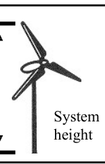
h. Tower: The monopole, guyed monopole or lattice structure that supports a wind generator.
i. Tower height: The height above grade of the fixed portion of the tower, excluding the wind generator.

j. Wind generator: The blades and associated mechanical and electrical conversion components mounted on top of the tower whose purpose is to convert kinetic energy of the wind into rotational energy used to generate electricity.
Procedure for Review:
Building Permit: Small wind energy systems and met towers are an accessory use permitted in all zoning districts where structures of any sort are allowed. No small wind energy system shall be erected, constructed, or installed without first receiving a building permit from the building inspector. A building permit shall be required for any physical modification to an existing small wind energy system. Met towers that receive a building permit shall be permitted on a temporary basis not to exceed 3 years from the date the building permit was issued.
Application: Applications submitted to the building inspector shall contain a site plan with the following information:
Property lines and physical dimensions of the applicant’s property.
Location, dimensions, and types of existing major structures on the property.
Location of the proposed small wind energy system, foundations, guy anchors and associated equipment.
Tower foundation blueprints or drawings.
Tower blueprints or drawings.
Setback requirements as outlined in this ordinance.
The right-of-way of any public road that is contiguous with the property.
Any overhead utility lines.
Small wind energy system specifications, including manufacturer, model, rotor diameter, tower height, tower type, nameplate generation capacity.
Small wind energy systems that will be connected to the power grid shall include a copy of the application for interconnection with their electric utility provider.
Sound level analysis prepared by the wind generator manufacturer or qualified engineer.
Electrical components in sufficient detail to allow for a determination that the manner of installation conforms to the NH State Building Code.
Evidence of compliance or non-applicability with Federal Aviation Administration requirements.
List of abutters to the applicant’s property.
Abutter and Regional Notification: In accordance with RSA 674:66, the building inspector shall notify all abutters and the local governing body by certified mail upon application for a building permit to construct a small wind energy system. The public will be afforded 30 days to submit comments to the building inspector prior to the issuance of the building permit. The building inspector shall review the application for regional impacts per RSA 36:55. If the proposal is determined to have potential regional impacts, the building inspector shall follow the procedures set forth in RSA 36:57, IV.
Standards:
The building inspector shall evaluate the application for compliance with the following standards;
Setbacks: The setback shall be calculated by multiplying the minimum setback requirement number by the system height and measured from the center of the tower base to property line, public roads, or nearest point on the foundation of an occupied building.
Small wind energy systems must meet all setbacks for principal structures for the zoning district in which the system is located.
Guy wires used to support the tower are exempt from the small wind energy system setback requirements.
Tower: The maximum tower height shall be restricted to 35 feet above the tree canopy within 300 feet of the small wind energy system. In no situation shall the tower height exceed 150 feet.
Sound Level: The small wind energy system shall not exceed 60 decibels using the A scale (DBA), as measured at the site property line, except during short-term events such as severe wind storms and utility outages.
Shadow Flicker: Small wind energy systems shall be sited in a manner that does not result in significant shadow flicker impacts. Significant shadow flicker is defined as more than 30 hours per year on abutting occupied buildings. The applicant has the burden of proving that the shadow flicker will not have significant adverse impact on neighboring or adjacent uses. Potential shadow flicker will be addressed either through siting or mitigation measures.
Signs: All signs including flags, streamers, and decorative items, both temporary and permanent, are prohibited on the small wind energy system, except for manufacturer identification or appropriate warning signs.
Code Compliance: The small wind energy system shall comply with all applicable sections of the New Hampshire State Building Code.
Aviation: The small wind energy system shall be built to comply with all applicable Federal Aviation Administration regulations including but not limited to 14 C.F.R. part 77, subpart B regarding installations close to airports, and the New Hampshire Aviation regulations, including but not limited to RSA 422-b and RSA 424.
Visual Impacts: It is inherent that small wind energy systems may pose some visual impacts due to the tower height needed to access wind resources. The purpose of this section is to reduce the visual impacts, without restricting the owner’s access to the optimal wind resources on the property.
The applicant shall demonstrate through project site planning and proposed mitigation that the small wind energy system’s visual impacts will be minimized for surrounding neighbors and the community. This may include, but not be limited to information regarding site selection, wind generator design or appearance, buffering, and screening of ground mounted electrical and control equipment. All electrical conduits shall be underground, except when the financial costs are prohibitive.
The color of the small wind energy system shall either be the stock color from the manufacturer or painted with a non-reflective, unobtrusive color that blends in with the surrounding environment. Approved colors include but are not limited to white, off-white, or gray.
A small wind energy system shall not be artificially lit unless such lighting is required by the Federal Aviation Administration (FAA). If lighting is required, the applicant shall provide a copy of the FAA determination to establish the required markings and/or lights for the small wind energy system.
Approved Wind Generators: The manufacturer and model of the wind generator to be used in the proposed small wind energy system must have been approved by the California Energy Commission or the New York State Energy Research and Development Authority, or a similar list approved by the state of New Hampshire, if available.
Utility Connection: If the proposed small wind energy system is to be connected to the power grid through net metering, it shall adhere to RSA 362- A:9.
Access: The tower shall be designed and installed so as not to provide step bolts or a ladder readily accessible to the public for a minimum height of 8 feet above the ground. All ground-mounted electrical and control equipment shall be labeled and secured to prevent unauthorized access.
Clearing: Clearing of natural vegetation shall be limited to that which is necessary for the construction, operation and maintenance of the small wind energy system and as otherwise prescribed by applicable laws, regulations, and ordinances.
Abandonment:
At such time that a small wind energy system is scheduled to be abandoned or discontinued, the applicant will notify the building inspector by certified U.S. mail of the proposed date of abandonment or discontinuation of operations.
Upon abandonment or discontinuation of use, the owner shall physically remove the small wind energy system within 90 days from the date of abandonment or discontinuation of use. This period may be extended at the request of the owner and at the discretion of the building inspector. “Physically remove” shall include, but not be limited to:
Removal of the wind generator and tower and related above-grade structures.
Restoration of the location of the small wind energy system to its natural condition, except that any landscaping, grading or below-grade foundation may remain in its same condition at initiation of abandonment.
In the event that an applicant fails to give such notice, the system shall be considered abandoned or discontinued if the system is out-of-service for a continuous 12-month period. After the 12 months of inoperability, the building inspector may issue a Notice of Abandonment to the owner of the small wind energy system. The owner shall have the right to respond to the Notice of Abandonment within 30 days from Notice receipt date. After review of the information provided by the owner, the building inspector shall determine if the small wind energy system has been abandoned. If it is determined that the small wind energy system has not been abandoned, the building inspector shall withdraw the Notice of Abandonment and notify the owner of the withdrawal.
If the owner fails to respond to the Notice of Abandonment or if, after review by the building inspector, it is determined that the small wind energy system has been abandoned or discontinued, the owner of the small wind energy system shall remove the wind generator and tower at the owner’s sole expense within 3 months of receipt of the Notice of Abandonment. If the owner fails to physically remove the small wind energy system after the Notice of Abandonment procedure, the building inspector may pursue legal action to have the small wind energy system removed at the owner’s expense.
Violation:
It is unlawful for any person to construct, install, or operate a small wind energy system that is not in compliance with this ordinance. Small wind energy systems installed prior to the adoption of this ordinance are exempt from this ordinance except when modifications are proposed to the small wind energy system.
Penalties:
Any person who fails to comply with any provision of this ordinance or a building permit issued pursuant to this ordinance shall be subject to enforcement and penalties as allowed by NH Revised Statutes Annotated Chapter 676:17.
§ 5.12Home Occupation
Amended March 2010, March 2019, March 2024
Business uses clearly secondary to the home/residence may be permitted, by special exception from the Zoning Board of Adjustment in accordance with Section 3.6, in the Residential/Agricultural Zone, Manufactured Housing/Mobile Home Zone, Professional/Residential Zone, and Route 33 Heritage District to allow a place of work.
Conditions:
A special exception for a home occupation shall be allowed subject to Section 17.8.2 and the following conditions and standards set forth below:
The total area occupied, including storage in accordance with “f” below, by a home occupation shall utilize an area of no more than twenty five percent (25%) of the total floor area of finished floor space of the dwelling, including the basement if finished as habitable space, or no more than 1,000 square-feet (whichever is less), and does not change the residential character of the premises thereof.
Revised March 2019, March 2024
The home occupation and the conduct thereof shall not impair the residential character of the premises and/or reasonable use, enjoyment and value of other residential property in the neighborhood. Further, such business shall not be injurious, noxious, or offensive to the neighborhood by reason of emission of odor, fumes, dust, smoke, vibration, and noise.
Home occupation shall be allowed only for a single-family residence and shall be carried on strictly by the owner of the principal building, who shall reside in said building or tenant (with owner's written permission) residing in the principal building. The residential use is established prior to the business use.
The granting of a special exception use shall be deemed to authorize the identified or particular use. The special exception shall expire if the authorized use ceases for more than twelve (12) months for any reason. The approval of a new application shall be required for reinstatement of the special exception use.
There shall be no more than two (2) persons outside the immediate family employed or otherwise engaged in the conduct of the business therein;
Storage in an accessory building or exterior storage may be permitted as a condition of the special exception granted by the Zoning Board of Adjustment. Exterior storage must be screened from neighboring views by either a solid fence, evergreens of an adequate height and bulk at the time of planting or by an existing combination of natural foliage and longer distances, to be determined sufficient by the Code Enforcement Officer.
Accessory finished goods may be provided for sale in conjunction with the home occupation, sold and stored in allowed home occupation space only.
The home occupation shall not be such that it requires regular or frequent service by heavy commercial trucks greater than 26,000-pound gross vehicle weight since this would adversely impact the character of the neighborhood.
Sufficient off-street parking for the employee and clients is to be provided. Any required deliveries can only be made by vehicles consistent with normal residential activities between the hours of 7:00 a.m. and 7:00 p.m. The outside parking of not more than two business vehicles on the lot are permitted in all residential zoned districts provided the vehicles:
Do not exceed 26,000 pounds gross vehicle weight.
Are used as a means of transportation to and from the resident's place of business and location of business activity.
Are not loaded with flammable, noxious, or dangerous materials.
Vehicle must be registered with the Town.
The business shall not be contrary to any covenants of conditions contained on the deed to the property.
Not more than one sign or other advertising device is to be displayed on the property and it shall not exceed a size of four (4) square feet. Signs will not be lighted from within or by exterior spot lighting.
Application for Special Exception & Home Occupation Permit; Inspections:
Special exceptions granted under this section are intended to allow for a specific business use. To apply for a home occupation special exception, a completed application form must be submitted to the Building Department. The applicant is required to provide:
A brief narrative describing the nature of the home occupation and providing details of the business and its scope of operation.
A sketch and/or drawing of the floor plan of the residence, clearly showing the dimensions of the living area and the area to be used for the business, including any proposed storage areas, and a plot plan of the property showing provisions for off-street parking and proposed outside storage area.
Revised March 2019
A copy of the deed must be submitted as part of the application to the Board when applying for the Special exception.
An accurate list of abutters and mailing addresses on labels.
Before a public hearing is held for a special exception under this section, a building inspection shall be conducted by the Code Enforcement Officer of the portions of the property to be utilized for the home occupation. At or within five days of the inspection, the Code Enforcement Officer will make the applicant aware of any life safety/building code improvements necessary to operate the home occupation. In addition, a formal site plan review by the Planning Board may be required if deemed necessary by the Zoning Board of Adjustment and/or Code Enforcement Officer.
Revised March 2024
Upon the granting of the special exception, the applicant shall be required to address any conditions of the special exception and other necessary improvements required by the Code Enforcement Officer. Prior to the start of operation, the applicant shall schedule a final inspection with the Town. If the proposed use meets all requirements of the special exception and those required under life safety/building codes, the Code Enforcement Officer shall issue a Certificate of Occupancy for the home occupation. Only home occupations with a valid Certificate of Occupancy may operate in Stratham.
Revised March 2024
All home occupation permits shall be issued for a period of three (3) years and may be renewed provided there is no violation of the provisions of Section 5.12. Requests for renewals shall be submitted to the Building Department within three years of the date of the original Certificate of Occupancy accompanied by the renewal fee as approved by the Select Board. The Code Enforcement Officer shall conduct an inspection of the home occupation prior to the approval of a renewal to ensure the use is operating in conformance with its Town approvals. The Town will mail one notice alerting the applicant of the need to renew the permit. The applicant shall be provided a 90-day grace period to file a renewal application. If no renewal application is filed within this period, the Certificate of Occupancy shall expire, and the home occupation must cease operation.
Revised March 2024
Periodic inspections of the home occupation premises may be required subsequent to the issuance of a home occupation permit in order to confirm compliance with the conditions of the original special exception granted. If, in the opinion of the Code Enforcement Officer and/or the Zoning Board of Adjustment, the conditions of the special exception have been violated, the Code Enforcement Officer may revoke the home occupation permit that was issued. Permit holders may make application to the Zoning Board of Adjustment for a new home occupation permit based on changed circumstances of the home occupation.
Exemptions from Special Exception Application Requirements:
Home occupations which meet all of the following criteria shall be considered exempt from these requirements and may operate without a special exception.
The business activity does not generate any additional traffic, including no customer and/or supplier traffic, apart from periodic business deliveries. Periodic business deliveries shall be defined as not more than five deliveries a week by vehicles weighing less than 26,000 pounds.
The business activity does not employ anyone who does not have a primary residence at the property.
No sign associated with the business activity is displayed at the property.
There is no outward appearance of a business activity on the property nor any noxious odors or noises produced by the home occupation.
No hazardous materials directly associated with the home occupation are maintained at the property.
§ 5.13Solar Energy Systems
Adopted March 2019
Purpose:
This solar energy systems ordinance is enacted in accordance with the purposes outlined in RSA 672:1-III-a. The purpose of this ordinance is to accommodate solar energy systems in appropriate locations, while protecting the public’s health, safety and welfare. In addition, this ordinance provides a permitting process for solar energy systems to ensure compliance with the provisions of the requirements and standards established herein.
Definitions:
a. Photovoltaic System (also referred to as Photovoltaic Installation): An active solar energy system that converts solar energy directly into electricity.
b. Rated Nameplate Capacity: The maximum rated output of electric power production of the photovoltaic system in watts of Direct Current (DC).
c. Solar Access: The access of a solar energy system to direct sunlight.
d. Solar Collector: A device, structure or a part of a device or structure for which the primary purpose is to transform solar radiant energy into thermal, mechanical, chemical, or electrical energy.
e. Solar Energy: Radiant energy received from the sun that can be collected in the form of heat or light by a solar collector.
f. Solar Energy System: A device or structural design feature, a substantial purpose of which is to provide daylight for interior lighting or provide for the collection, storage and distribution of solar energy for space heating or cooling, electricity generation, or water heating.
g. Solar Energy System, Active: A solar energy system whose primary purpose is to harvest energy by transforming solar energy into another form of energy or transferring heat from a collector to another medium using mechanical, electrical, or chemical means.
h. Solar Energy System, Grid-Intertie: A photovoltaic system that is connected to an electric circuit served by an electric utility.
i. Solar Energy System, Ground-Mounted: An Active Solar Energy System that is structurally mounted to the ground and is not roof-mounted; may be of any size (small, medium, or large-scale).
j. Solar Energy System, Large-Scale: An Active Solar Energy System that occupies more than 40,000 square feet of surface area (equivalent to a rated nameplate capacity of about 250kW DC or greater).
k. Solar Energy System, Medium-Scale: An Active Solar Energy System that occupies more than 1,750 but less than 40,000 square feet of surface area (equivalent to a rated nameplate capacity of about 10 - 250 kW DC).
l. Solar Energy System, Off-Grid: A photovoltaic solar energy system in which the circuits energized by the solar energy system are not electrically connected in any way to electric circuits that are served by an electric utility.
m. Solar Energy System, Passive: A solar energy system that captures solar light or heat without transforming it to another form of energy or transferring the energy via a heat exchanger.
n. Solar Energy System, Roof-Mounted: An Active Solar Energy System that is structurally mounted to the roof of a building or structure; may be of any size (small-, medium- or large-scale).
o. Solar Energy System, Small-Scale: An Active Solar Energy System that occupies 1,750 square feet of surface area or less (equivalent to a rated nameplate capacity of about 10 kW DC or less).
p. Solar Thermal System: An Active Solar Energy System that uses collectors to convert the sun’s rays into useful forms of energy for water heating, space heating, or space cooling.
Use Regulations (Table 1):
This table states the uses that are permitted by right, are permitted by a conditional use permit, or are prohibited. Permitted uses are designated in the Table with a P; uses that require a conditional use permit from the Planning Board are designated with a C; and prohibited uses are designated with an X.
Those solar energy systems that require a Conditional Use Permit shall obtain a Conditional Use Permit from the Planning Board, subject to Section 3.6 Additional Notes. The Conditional Use Permit is meant to provide flexibility, minimize adverse impacts, and allow the Board to participate jointly with the applicant to prepare a development that is consistent with this ordinance, regulations, and the Master Plan for the Town of Stratham.
The Conditional Use Permit shall clearly set forth all conditions of approval and shall clearly list all plans, drawings, and other submittals that are part of the approved use. Everything shown or otherwise indicated on a plan or submittal that is listed on the Conditional Use Permit shall be considered to be a condition of approval. Construction shall not deviate from the stated conditions without approval of the modification by the Planning Board.
| Table 1 | Residential Zones (R/A, MH, RPC, FMU) | Commercial Zones (GCBD, CLIO, PRE, TC) | Industrial Zone (IND) | Route 33 Legacy Highway Heritage District (LHHD) |
|---|---|---|---|---|
| PRINCIPLE USE | ||||
| Medium-Scale Ground-Mounted Solar Energy System | C | P | P | C |
| Large-Scale Ground-Mounted Solar Energy System | X | C | C | X |
| ACCESSORY USE | ||||
| Roof-Mounted Solar Energy System | P | P | P | P |
| Small-Scale Ground-Mounted Solar Energy System | P/C¹ | P/C¹ | P/C¹ | P/C¹ |
| Medium-Scale Ground-Mounted Solar Energy System | C | C | C | C |
P = Permitted; C = Conditional Use Permit; X = Not Permitted
¹ Small-Scale Ground Mounted Solar Energy Systems shall be permitted by right if the application conforms to all of the following requirements:
The solar energy system is sited in the rear yard only and the application shall not include the clear-cutting of vegetation or the removal of mature trees located within 20-feet of any lot boundary.
The solar energy system is sited a minimum of 50-feet from the front property boundary (or any lot boundary that directly borders a road frontage) and a minimum of 35-feet from all property boundaries.
The solar energy system complies with the minimum setback requirements of the Wetland Conservation and Shoreland Protection Districts.
The solar energy system does not exceed a maximum height (tallest point of structure) of 12-feet above natural grade.
Small-scale solar energy systems on commercial, industrial, mixed-use, or multi-family residential properties shall be subject to the Stratham Site Plan Regulations.
Small-Scale Ground Mounted Solar Energy Systems that do not conform to all of the criteria above shall be permitted by Conditional Use Permit only.
Revised March 2026; added March 2026
Dimensional Regulations:
Solar Energy System structures must comply with Table 4.2 of the Zoning Regulations unless otherwise permitted by section 5.13.
Exceptions:
Mechanical equipment and appurtenances necessary to the operation or maintenance of the building or structure itself, for the installation of roof- mounted solar energy systems may exceed the maximum height limitation of the underlying zoning district by no more than 25% of the zoning districts maximum allowed height.
Ground mount installations shall be limited to a height (tallest point of structure) of no more than twenty one (21) feet above natural grade.
Revised March 2020
Setbacks:
Small-scale ground-mounted solar energy systems must adhere to all of the setback requirements of the applicable zoning district. All ground-mounted solar energy systems in residential districts shall be installed either in the side yard or rear yard to the greatest extent practicable.
Medium- and Large-scale ground-mounted solar energy systems shall be set back a minimum of 60 (sixty) feet from the front property line or any boundary with a public right-of-way and adhere to all other setback requirements for structures of the applicable zoning district (Rev. 3.22).
Solar energy systems shall not be included in calculations for lot coverage or impervious cover as defined in the Town of Stratham Site Plan Review Regulations.
Site Plan Review Requirements and Performance Standards:
Applicability: Any Solar Energy systems requiring a Conditional Use Permit shall be subject to Site Plan Review as follows:
Site Plan Document Requirements:
Pursuant to the Site Plan Review process, the project proponent shall provide the following documents, as deemed applicable by the Planning Board:
A site plan showing:
Property lines and physical features, including roads, for the project site;
Proposed changes to the landscape of the site, grading, vegetation clearing and planting, exterior lighting, screening vegetation or structures;
Blueprints or drawings of the solar energy system showing the proposed layout of the system, any potential shading from nearby structures, the distance between the proposed solar collector and all property lines and existing on-site buildings and structures, and the tallest finished height of the solar collector;
Documentation of the major system components to be used, including the panels, mounting system, and inverter;
Name, address, and contact information for proposed system installer;
Name, address, phone number and signature of the project proponent, as well as all co- proponents or property owners, if any;
The name, contact information and signature of any agents representing the project proponent; and
Zoning district designation for the parcel(s) of land comprising the project site.
Proof that the project proponent will meet the required Site Plan Review notification procedures
Site Plan Review Design Standards:
Utility Notification - No grid-intertie photovoltaic system shall be installed until evidence has been given to the Site Plan Review Authority that the owner has submitted notification to the utility company of the customer’s intent to install an interconnected customer-owned generator. Off-grid systems are exempt from this requirement.
Utility Connections - Reasonable efforts, as determined by the Site Plan Review Authority, shall be made to place all utility connections from the solar photovoltaic installation underground, depending on appropriate soil conditions, shape, and topography of the site and any requirements of the utility provider. Electrical transformers for utility interconnections may be above ground if required by the utility provider.
Safety - The medium-scale ground-mounted solar energy system owner or operator shall provide a copy of the Site Plan Review application to the local fire chief. All means of shutting down the solar installation shall be clearly marked.
Visual Impact - Reasonable efforts, as determined by the Site Plan Review Authority, shall be made to minimize visual impacts by preserving natural vegetation, screening abutting properties, or other appropriate measures.
Land Clearing, Soil Erosion and Habitat Impacts - Clearing of natural vegetation should be limited to what is necessary for the construction, operation and maintenance of ground-mounted solar energy systems or as otherwise prescribed by applicable laws, regulations, and bylaws/ordinances.
Site Plan Review—Full compliance with the Town of Stratham Site Plan Review Regulations shall be required for all Large Scale Ground Mount Installations.
The owner of a Medium or Large Scale ground mounted solar energy system shall establish a performance bond, or provide the Town of Stratham with an irrevocable letter of credit in the same amount, ensuring adequate funds to return the site to pre- solar energy system condition. In the event of a transfer of ownership, the seller shall be responsible for notifying the buyer of this requirement and for notifying the Town of the transfer.
Monitoring and Maintenance:
Solar Energy System Installation Conditions - The large-scale ground- mounted solar energy system owner or operator shall maintain the facility in good condition. Maintenance shall include, but not be limited to, painting, structural repairs, and integrity of security measures. Site access shall be maintained to a level acceptable to the local Fire Chief Emergency Management Director, and Emergency Medical Services. The owner or operator shall be responsible for the cost of maintaining the solar energy system and any access road(s), unless accepted as a public way.
Modifications - All material modifications to a large-scale ground- mounted solar energy system made after issuance of the required building permit shall require approval by the Site Plan Review Authority.
Abandonment or Decommissioning:
Removal Requirements:
Any medium or large-scale ground-mounted solar energy system which has reached the end of its useful life or has been abandoned, consistent with Section 5.13.9.2 of this bylaw/ordinance shall be removed. The owner or operator shall physically remove the installation no more than 150 days after the date of discontinued operations. The owner or operator shall notify the Site Plan Review Authority by certified mail of the proposed date of discontinued operations and plans for removal.
Decommissioning shall consist of:
Physical removal of all solar energy systems, structures, equipment, security barriers and transmission lines from the site.
Disposal of all solid and hazardous waste in accordance with local, state, and federal waste disposal regulations.
Stabilization or re-vegetation of the site as necessary to minimize erosion. The Site Plan Review Authority may allow the owner or operator to leave landscaping or designated below-grade foundations in order to minimize erosion and disruption to vegetation.
Abandonment:
Absent notice of a proposed date of decommissioning or written notice of extenuating circumstances, the medium or large-scale ground- mounted solar energy system shall be considered abandoned when it fails to operate for more than one year without the written consent of the Site Plan Review Authority. If the owner or operator of the solar energy system fails to remove the installation in accordance with the requirements of this section within 150 days of abandonment or the proposed date of decommissioning, the Town retains the right, after the receipt of an appropriate court order, to enter and remove an abandoned, hazardous, or decommissioned large- scale ground-mounted solar energy system. As a condition of Site Plan approval, the applicant and landowner shall agree to allow entry to remove an abandoned or decommissioned installation
Return to Pre-development Condition:
In the event that a medium- or large-scale ground-mounted solar energy system is abandoned, the owner of the property shall be required to return the land to its pre-development condition. Accordingly, applicants for ground-mounted medium- and large-scale solar energy systems shall be required to provide the Planning Board, as part of its application materials, a plan for decommissioning ground-mounted solar energy facilities and restoring the site to its pre-development condition. Additionally, the property owner must sign a Declaration, to be recorded at the Registry of Deeds, committing the owner to removing the solar panels and restoring the site to its pre-development condition within 90 days of abandonment of a medium- or large-scale solar energy system.
Revised March 2023
Removal of Abandoned Ground- mounted solar energy system:
Any ground- mounted solar energy system that is not operated for a continuous period of twelve (12) months shall be considered abandoned and hazardous to the public health and safety, unless the owner of said ground mounted solar energy system provides proof of quarterly inspections. The owner shall remove the abandoned structure(s) within ninety (90) days of receipt of a declaration of abandonment from the Town notifying the owner of such abandonment. A declaration of abandonment shall only be issued following a public hearing, noticed per Town regulations, with notice to abutters and the last known owner/operator of the ground- mounted solar energy system. If the abandoned ground-mounted solar energy system is not removed within ninety (90) days pursuant to the requirements of Section 5.13.9.3, the Town may execute enforcement proceedings to compel action. If there are two (2) or more users of a single ground- mounted solar energy system, this provision shall not become effective until all users cease using the ground-mounted solar energy system
Revised March 2023
§ 5.14Small Accessory Structures
Adopted March 2024
Small accessory structures or sheds less than or equal to 120 square-feet in area may be constructed no less than five (5) feet from a side and/or rear property boundary and no less than 15 (fifteen) feet from a wetland boundary and shall not require the issuance of a building permit, if all criteria in 5.14.1 are met.
Criteria
The structure shall not contain a poured concrete foundation or slab.
The height of the shed shall not exceed 12 feet as measured to the roof peak.
A maximum of one shed per parcel shall be allowed under this section.
The shed shall not be constructed within the 50-foot vegetated buffer strip that is required to be maintained along the external perimeter or property line of a Residential Open Space Cluster Development.
This section shall not apply to parcels that are subject to site plan review by the Planning Board.
Section VITechnical Review Committee
§ 6.1Purpose
The Technical Review Committee (TRC) is hereby established to assist the Planning Board in its review of major site plan and subdivision applications as defined by Stratham’s Subdivision and Site Plan Regulations.
The TRC reviews proposals to ensure compliance with all applicable regulations and further evaluates the need for technical aspects of the proposal, including (but not limited to) traffic impacts, public and life safety, stormwater management, utility infrastructure, and building design. Condominium conversions are subject to review by the TRC. Depending on the complexity of the proposal, the TRC may also review additional Planning Board applications as necessary, including (but not limited to) minor site developments, minor subdivisions, and conditional use permits.
§ 6.2Members
The Technical Review Committee (TRC) shall be comprised of the Director of Planning & Building (who shall act as the Chair), the Police Chief (or their designee), the Fire Chief (or their designee), the Code Enforcement Officer, the Director of the Public Works Department (or their designee), a Conservation Commission member, a Heritage Commission member and a Planning Board member. Other Town departments, commissions, committee members, or Subject Matter Experts of the community may participate as needed.
§ 6.3Procedure
Upon receipt of a major site plan or subdivision application, the Director of Planning and Building (or their designee) will conduct an initial review of the application to ensure all required information has been provided, after which a meeting of the TRC will be scheduled. Said meeting(s) shall serve to assist the applicant in preparing a development proposal that is technically sound and conforming to the regulations contained herein.
Members of the public may attend meetings of the TRC but may not address the TRC members with any comments, questions, or concerns. Comments, questions, or concerns may be addressed by the public to the Planning Board at its scheduled meeting(s).
Planning and Building Department staff shall inform the applicant (or its representative) not less than ten days prior to the scheduled TRC meeting date if said application requires such a postponement.
Following the Technical Review Committee meeting, the Director of Planning and Building (or designee) will provide a written summary of TRC’s feedback to the Planning Board.
§ 6.4Amendment
These procedures governing the Technical Review Committee (TRC) may be supplemented by the Planning Board as deemed necessary to improve the efficiency and effectiveness of the land use review process, by amendments to the Stratham Subdivision and Site Plan Regulations.
Section VIISigns
§ 7.1Purpose & Intent
The purpose of this Section is to establish uniform regulations for the installation and use of signs in the Town of Stratham and to protect and improve the livability and quality of life in Stratham through sign regulations that:
Encourage the effective use of signs as a means of communication in Stratham;
Protect the health, safety, and welfare of the public, with a specific focus on improving pedestrian and traffic safety by reducing distractions to motorists and limiting the visual impacts of signage along roadways;
Maintain and enhance the appearance and aesthetic environment of Stratham, including of the community’s commercial corridors;
Maintain and enhance the rural, agricultural, and historical character of Stratham;
Control visual clutter along roadways and on buildings and encourage high-quality professional standards in sign design and display.
Retain and enhance the Town's ability to attract and encourage economic development and community vitality.
To reduce light pollution and glare associated with exterior lighting sources and to preserve and enhance the visibility of night-time skies in all areas of Stratham.
§ 7.2Definitions
The following words and phrases shall have the meaning described herein for all purposes associated with the construction and interpretation of the Sign Ordinance.
a. Flag: A piece of cloth or similar material, typically oblong or square, attachable by one edge to a pole or rope and used as the symbol or emblem of a country or institution; a decoration during public festivities; or displayed outside a business and solely containing one word such as “open”, “antiques”, “food”, or “restaurant”.
b. Lineal Building Frontage: The length of a ground level straight line or lines parallel to and equaling the length of the building front that includes the main public entrance(s) or the side of the building fronting on the principal roadway. In the case of a multi- unit development the frontage of each separate building is additive for the purpose of determining permissible sign area.
c. Sign: Any name, identification, description, display, illustration, or device which is affixed to or represented directly or indirectly upon a building, structure or land in view of the general public, and which directs attention to a product, place, activity, person, institution, or business. A sign shall include writing, representation, or other figure of similar character within a building only when illuminated and located in a window.
d. Sign, Agricultural, Temporary / Seasonal: A temporary sign advertising or providing direction to a Farm Stand or farm/agricultural sales activity. The sign shall be seasonal or temporary in nature, may be located off-site, and within a public right-of-way.
Adopted March 2007
e. Sign, Attached: A sign, which is attached to a building wall and which extends eighteen (18) inches or less from the face of such wall.
f. Sign, Awning: A sign painted on or attached flat or flush against the surface of the awning, but not extending above, below or beyond the awning or attached to the underside. The copy area on awnings is computed as all or a portion of the allowed wall sign area.
Adopted March 2011
g. Sign, Canopy or Marquee: Any sign attached to or part of a canopy or marquee. The copy area on such signs is computed as all or a portion of the allowed wall sign area.
Adopted March 2011
h. Sign, Contractor's / Development Sign: A temporary sign displayed on a parcel with an active building permit for a major renovation project or new development.
Revised March 2023
i. Sign, Directional: Signage necessary for on-site public safety and convenience.
Adopted March 2011
j. Sign, Directory: Signs which are necessary to identify and locate occupants of a building, including office buildings, residences, and church directories.
Adopted March 2011
k. Sign, feather flag: An upright portable sign that contains a harpoon-style pole or staff driven into the ground for support or supported by means of an individual stand.
Adopted March 2025
l. Sign, Flashing: Any sign or signal light with continuously variable illumination, whether achieved electrically or mechanically.
m. Sign, Freestanding / Monument: A sign established on a freestanding frame, mast or pole and not attached to any building. Where such signs are established back to back, the larger face shall be used for the calculation of allowable area. Also known as detached sign, freestanding sign, pole sign, ground sign or pylon sign.
Adopted March 2011
n. Sign, Height: The vertical distance measured from the adjacent undisturbed grade of the sign to the highest point of the sign.
Adopted March 2011
o. Sign, Historic Marker: A marker that identifies an historic place, person, event, or date and is erected by a historical organization or by a government agency.
Adopted March 2011
p. Sign, Illuminated: Any sign which emanates light either by means of exposed tubing, electrical bulbs, fluorescent lights, neon tubes, or lamps on its surface, or by means of illumination transmitted through the sign face(s). Any decorative lighting that is used expressly for the purpose of advertisement shall be construed as a sign.
Adopted March 2011
q. Sign, Landmark: An older sign of artistic or historic merit, uniqueness, or extraordinary significance, as identified by the local historical organization. The character of landmark signs warrants their preservation in original condition, or their restoration.
Adopted March 2011
r. Sign, Nonconforming: Any sign which was lawfully established prior to the date this Ordinance was adopted, and which fails to conform to the specifications of this Ordinance.
Adopted March 2011
s. Sign, Permanent: A permanent sign is any sign established for a period of greater than six (6) months.
Adopted March 2011
t. Sign, Political: Signs that advertise a candidate, party, position, or other political issue. The provisions of RSA Chapter 664 and any other applicable state laws relative to political advertising are incorporated herein by reference.
u. Sign, Projecting: A sign attached to a building or other structure and extending in whole or in part more than fourteen (14) inches beyond the building.
Adopted March 2011
u. Sign Structure: Any framework, either freestanding or an integral part of the building, which supports or is capable of supporting any sign, including decorative cover.
Adopted March 2011
v. Sign, Temporary: A ground-mounted sign or a banner affixed to the façade of a structure, without a permanent foundation, established for any period of less than 120 days. A temporary sign shall not include Contractor’s/Development signs, signs located on parcels that are for sale or lease, or political signage.
Revised March 2023
w. Sign, Utility: These signs are noncommercial in nature and identify the location of gas lines, water lines or phone cables, often warning of the potential hazard of digging or excavation in the immediate area.
x. Sign, Wall/Building: Any sign attached parallel to the building wall or other surface to which it is mounted that does not extend more than fourteen (14) inches from said surface and has only one (1) sign face that is intended to be read parallel to the wall or other surface to which it is mounted. This sign also includes any sign established on any other part of a building provided that the sign is on a plane parallel to the wall of the building. Wall/Building signs may not project above the top of a parapet, wall, or the roof line at the wall, whichever is highest. A wall/building sign is also a sign established on a false wall or false roof that does not vary more than thirty (30) degrees from the plane of the building’s parallel wall.
Adopted March 2011
§ 7.3Administration
The Administrator of this sign Ordinance shall be the Code Enforcement Officer. The Code Enforcement Officer shall have the responsibility and authority to administer and enforce all provisions of this Ordinance, other than those provisions with powers specifically reserved to the Board of Selectmen, Planning Board, or the Zoning Board of Adjustment.
All signs shall be reviewed for compliance with the applicable state and federal building codes.
Site Plan Review – When proposed as part of a new development or redevelopment, the proposed signage, to the highest extent practicable, shall be included in the site plan application materials for review by the Planning Board. This information shall include the proposed dimensions and illumination sources of proposed signage.
Relief – Any relief sought from the requirements of this sign ordinance may be brought before the Planning Board in the form of a Conditional Use Permit application. The Planning Board shall have the authority to grant or deny a request for a Conditional Use Permit, pursuant to the provisions of RSA 674:16 and RSA 674:21, after proper public notice and public hearing where the Planning Board finds that an application complies with standards i and ii below.
The application shall comply with all of the purpose statements of this Sign Ordinance as stipulated under Section 7.1
Deviations from this Sign Ordinance shall be to the smallest extent necessary to both comply with the purpose statements of this Ordinance and to fulfill the objectives of the applicant.
§ 7.4Permit Procedures
(Deleted 3/23)
§ 7.5Exempt Signs
Revised March 2016, March 2018
The following signs are exempt from the permit requirements of this Article, but are otherwise subject to the standards contained herein. Any failure to comply with these standards and any other provisions of this Article shall be considered a violation of the Zoning Ordinance.
Nameplate signs giving property identification names or numbers, or names of occupants.
Signs on mailboxes or newspaper tubes.
Signs required by Town Ordinance.
Historic marker signs, provided that said signs are no more than two (2) square feet.
Directory Signs, located at least 25 (twenty-five) feet from a right-of-way, that do not exceed four (4) square feet in area.
Landmark Signs or other signs that are located on, or are an integral part of, a property that has been placed on or determined eligible for the National Register of Historic Places, provided that such signs are recognized as contributing to the National Register status of the property.
Flags, of no more than 15 square feet in size.
Wall or window signs no greater than two (2) square feet in area provided that such signage is limited to no more than six signs per use.
§ 7.6Prohibited Signs
Revised March 2019, March 2023
The following signs are prohibited:
Any sign located within, on, or projecting over a property line which borders a public or private street, highway, alley, lane, parkway, avenue, road, sidewalk, or other right-of-way, except as provided in this Ordinance. The Code Enforcement Officer may cause to be removed any temporary or portable sign erected or displayed upon, or projecting into public property.
Any flashing sign or other sign or lighting device, whether freestanding, on the exterior of the building, or on the inside of a window which is visible beyond the boundaries of the lot or parcel, or from any public right-of-way, with intermittent, animated, flashing, rotating, scintillating, blinking, or strobe light illumination, including a variable electronic message device, or the regulations applicable to a particular sign structure.
Signs, which by reason of location, size, color, or design interfere with public traffic or can be confused with or obstruct the view or effectiveness of any official traffic signal or traffic marking.
Any sign with unshielded incandescent, metal halide, or fluorescent light bulbs.
Any off-premises permanent sign or signs which are located off of the property that they are advertising, except as provided for herein.
Any rotating sign.
Any banners, pennants, or feather flags.
Revised March 2025
Strings of light bulbs whether in conjunction with a sign or not except as conventionally used as part of a holiday celebration.
Any sign which causes glare onto a public road or any neighboring property.
Any inflatable sign and other similar permanent objects.
Any sign including a mirror device.
Internally illuminated signs.
Revised March 2023
Any sign which is placed so as to prevent or inhibit free ingress to or egress from any door, window, or exit way required by the Building Code or the Fire Code; and,
Any sign mounted, attached, or painted on a trailer, boat, or motor vehicle when parked, stored, or displayed conspicuously on the public right-of-way or private premises in a manner intended to attract attention of the public for business advertising purposes are considered portable signs within the context of this Ordinance and are prohibited. This provision expressly excludes business signs that are permanently painted on, or magnetically attached to motor vehicles or rolling stock that are regularly and consistently used to conduct normal business activities; where such vehicles or rolling stock are stored at their place of business in a manner to be screened from public ways (fence, garage, etc.) or otherwise parked so as not to be visible as a freestanding sign. However, this section does not prohibit an individual, not engaged in business, to display a sign, mounted, attached or painted on a trailer, boat or motor vehicle, when it is parked for the purpose of a one-time sale of said trailer, boat or motor vehicle.
Revised March 2019
Consistent with existing current federal caselaw and constitutional protections, the Town will not regulate sign content, with the exception of obscene speech. Signage shall not include obscene speech. Obscene speech is defined as content that appeals to the prurient interests in sex, which describes, represents or portrays sexual conduct in a patently offensive way, and when the signage, viewed as a whole, does not include any serious literary, artistic, political, or scientific value.
Added March 2023
§ 7.7Enforcement and Violations
Any person, including, without limitation, an owner of real property, who violates, suffers a violation to occur or refuses to comply with any provision of this Ordinance may be subject to the penalty provisions as described in Section XXII of the Zoning Ordinance.
In addition to the remedies provided in Section XXII, the Code Enforcement Officer may remove or cause to be removed any sign that does not comply with the provision of this Ordinance, at the expense of the owner of the property wherein the sign is located after written notification of the violation to the property owner.
The Code Enforcement Officer may remove or cause to be removed any sign without notice that the Code Enforcement Officer reasonably concludes is impermissibly established in the public right-of-way or that otherwise constitutes a danger to public safety.
§ 7.8General Standards and Criteria for Signs
The regulations in this section specify the area and heights of signs that are allowed within the Town and which require a permit.
Measurement and Calculation of Area:
Area of Freestanding Signs:
Sign face area is calculated as the total area within the smallest square, circle, rectangle, triangle, or combination thereof that will encompass the extreme limits of the writing, representation, emblem, or other display together with any material or color forming an integral part of the background of the display or used to differentiate the sign from the backdrop, background, or structure against which it is placed. Areas of supporting framework shall be excluded from this calculation up to the amount of 35% of the total area as calculated above. All supporting framework, bracing, or decoration in excess of the 35% limit shall be deemed part of computation of the maximum aggregate area.
Area of Wall/Building Signs:
The sign face area of signs attached or affixed to buildings or other structures shall include all lettering, designs, or symbols, together with the background, whether open or enclosed, upon which they are displayed. When signs are incorporated into canopies or awnings, the entire panel containing the sign copy is counted as the sign face area.
In no case can the additional surrounding background area exceed the area of the copy. For the purpose of this section, the permitted background area is the total area between the lintel bar and the parapet on a one (1) story building or between the lintel bar and the floor level of the floor above on a multi-story building
Signage Standards:
Design, color, materials, size, and placement are all important in creating signs that are architecturally attractive and integrated into the overall site design. Signs that are compatible with the surroundings and effectively communicate a message will promote a quality visual environment. The following design standards will be used as a basis for review of sign permits and the management of signs:
General Standards:
Signs should be clear, informative to the public and should weather well.
Sign letters and materials should be professionally designed and fabricated.
Exposed conduit and tubing is prohibited. All power supplies and other equipment shall be concealed.
The exposed back of all signs visible to the public shall be suitably finished and maintained.
Placement:
Signs shall be located with respect to the basic architectural framework of the building, so as not to obscure the primary elements (door and window openings and decorative facade treatments) of a building’s framework.
Lettering:
Lettering and signboards shall be located so as not to obstruct architectural detailing on the building face.
Material:
Traditional materials, such as wood, glass, brass, bronze, aluminum, or iron are preferred for the framework of a sign. The use of plastic, aluminum and vinyl will only be permitted if styled and composed to imitate wood or iron.
Sign Illumination:
Externally illuminated signage from a light source that is fully downcast is permitted.
Internally illuminated or backlit signage is prohibited.
§ 7.9General Regulations
Revised March 2011, March 2019
Any sign not specifically listed shall not be permitted unless otherwise exempted herein.
Signs Permitted in the Residential/Agricultural District, Manufactured Housing/Mobile Home District, Retirement Planned Community District:
Signs on properties with a primary agricultural use shall be permitted signage subject to the following requirements:
On properties where agriculture is the primary use of property:
Wall signage shall be permitted subject to the requirements of Section 7.9.viii of the Ordinance.
One permanent freestanding sign not to exceed 32 square-feet in area and ten feet in height shall be permitted.
One Temporary Sign shall be permitted subject to the requirements of Section 7.9.viii except that signs may be permitted up to 50 square-feet in size and up to eight signs may be permitted in a single calendar year for a period not to exceed 180 days
On properties where agriculture is an accessory use of a property.
One wall sign not to exceed 10 square-feet in area shall be permitted.
One permanent freestanding sign not to exceed 20 square-feet in area and six-feet in height shall be permitted.
One Temporary Sign shall be permitted subject to the requirements of Section 7.12
Real estate, contractor, and development signage:
On properties that are currently listed for sale or for lease, one additional temporary sign may be permitted, in addition to any temporary sign permitted under Section 7.9.viii of the Ordinance, for the duration that the property is listed for sale or for lease. Signage of this nature shall not be illuminated.
On properties that are actively under land development, one temporary sign not to exceed 24 square-feet in area shall be permitted. Signage of this nature shall not be illuminated.
Properties where an approved Home Occupation is actively in operation shall be permitted signage subject to the following regulations:
Not more than one free standing sign or other advertising device is to be displayed on the property and it shall not exceed a size of four (4) square feet.
Home Occupation signs shall be located outside of the public right-of-way.
The height of Home Occupation signs shall be a minimum of eight (8) feet in height and a maximum height of ten (10) feet.
Signs will not be lighted from within or by exterior spot lighting.
Vehicles displaying advertising for a Home Occupation shall be screened from public ways (fence, garage, etc.) or otherwise parked so as not displayed as a freestanding sign.
Revised March 2019
Residential Development Signs:
Residential subdivisions or developments of five or more housing units served by a public or private road shall be permitted one sign for the purposes of identifying the housing development. Residential Development signs shall be monument style signs, as defined under Section 3.8.10.c.ii of the Ordinance, except that such signs may be up to 24 square-feet in sign area and stand up to six-feet in height. The property owners or a Homeowner’s Association shall be responsible for the maintenance of such sign
Signs Permitted in commercial and/or industrial uses:
All signs permitted in the Residential / Agricultural District, Manufactured Housing / Mobile Home District, and Retirement Planned Community District pursuant to Section 7.9.a.
Awning/Canopies:
One sign with lettering per business shall be permitted on an awning or canopy, and logos shall be permitted on all awnings and canopies, provided that:
The letter and logo height does not exceed 50% of the diagonal portion of the awning or canopy.
The letter and logo height is located on the vertical flap and does not exceed eight inches.
The letter and logo area does not exceed 15% of the area of the diagonal portion of the awning or canopy.
The signage shall only be on first-floor awnings and canopies.
Awnings and canopies shall be kept in good order and repair.
All awning and canopies shall be made of cloth or canvas.
Free Standing Signage:
Flexible Mixed-Use District, Professional/Residential District, and Town Center District.
Properties with one operation under a single proprietorship shall be permitted up to one freestanding sign not to exceed 30 square-feet in area. For each additional operation under different proprietorship, a maximum of 10 (ten) additional square-feet of signage shall be permitted up to 40 additional square-footage of signage for a maximum of 70 square-feet of signage. No freestanding sign in these districts shall exceed a height of 10-feet.
Gateway Commercial Business District, Special Commercial District, Commercial/Light Industrial District, and Industrial District.
Properties with one operation under a single proprietorship shall be permitted up to one freestanding sign not to exceed 35 square-feet in area. For each additional operation under different proprietorship, a maximum of 15 additional square-feet of signage shall be permitted up to a maximum of 95 square-feet of signage. No freestanding sign in these districts shall exceed a height of 12-feet
One (1) freestanding sign shall be permitted for each street or limited access highway, which abuts a lot, up to a maximum of two freestanding signs provided that the secondary freestanding sign is clearly oriented to the secondary right-of-way and frontage. The area of the sign located on the primary lot frontage (determined by the applicant) shall be the maximum permitted in the district. The area of sign located on the secondary lot frontage shall be 50% of maximum permitted area in the district and shall not exceed a height of six-feet.
Minimum front yard setback, side yard setback and rear yard setback. Unless otherwise stated in the Ordinance, there shall be no minimum required front, side, or rear setback for freestanding signs, provided, however, such signs shall not encroach into any public right-of-way or any clear sight area and be located a minimum of 6 (six) feet from the edge of pavement for the right-of-way.
Projecting signs and displays attached to individual buildings or units shall be allowed in addition to the permitted freestanding signs and displays, subject to the following:
There is no more than one such sign for each entrance door to a business establishment.
The permitted area of projecting signs shall be one (1) square foot for each five (5) linear feet of building or unit front facade to which it is attached, not to exceed twenty-five (25) square feet.
The base of all projecting signs shall be no less than eight (8) feet above the ground or sidewalk.
Projecting signs shall not be located or erected on the roof area of any building, shall be located only on the building walls, and may not project above the building roof line or roof ridge.
Projecting signs shall not project from the exterior wall of a building more than five (5) feet.
Projecting signs shall not project into any public or private street travel way.
There are no exposed guy wires or turnbuckles.
In the case of a building located on a corner lot, a projecting building sign may be located at the corner of the building oriented toward the intersection of two or more streets, provided, however, that no other projecting building identification signs shall be located on the same building within one-hundred (100) feet of a corner projecting building identification sign, regardless of orientation
Wall/Building Signage:
Externally illuminated wall signage with a fully downcast light source is permitted. Internally illuminated, or backlit signage, is prohibited. Lighting for signage shall be turned off between the hours of 11 pm to 5 am, unless a business or use is in operation during those hours in which case sign lighting must be turned off within one hour of the closure or opening of the business.
Wall signage must be located no more than 18-feet above grade level or below the lowest part of the roofline, whatever is lower.
The building frontage is used to calculate the total maximum wall/building sign area. One square foot of wall/building sign area is allowed for each linear foot of building frontage. The area of all wall/building signs must be equal or less than this total, including existing and new signs. The building sign total maximum area formula shall be calculated using the following formula:
Building Linear Frontage x Multiplier (see chart below) = Total maximum sign area for all building signs.
x = square feet
Total Maximum Area Multiplier:
The total aggregate area in square feet of all permanent building signs, except for signs freestanding signs and directional signs, shall not exceed the following:
| Average Distance of Sign From Centerline of Abutting Street | Building Frontage Multiplied By |
|---|---|
| 0-149 | 1 |
| 150-249 | 1.5 |
| 250 and over | 2 |
For lots with frontage on more than two streets or a limited access highway, the total maximum area for wall/buildings signs shall be determined using the maximum area permitted for the primary lot frontages (as determined by the applicant). Additional wall signage shall be permitted for the secondary frontage, however wall signage for the secondary frontage shall not be subject to the maximum area multiplier and shall be limited to no more than 50 percent of what is permitted for the primary frontage.
Allowable wall signage may be distributed on different building facades, however no single building façade may include more than 75 square-feet of wall signage unless the site qualifies for the Total Maximum Area Multiplier. If any building frontage of the site is located between 150-249 feet from the roadway centerline, a maximum of 105 square-feet of signage on a single building façade is permitted. If any building frontage is located more than 249-feet from the roadway centerline, a maximum of 135 square-feet of wall signage is permitted on a single building façade.
§ 7.10Maintenance and Obsolescence
All signs and sign structures shall be properly maintained and kept in a neat and proper state of maintenance and appearance. All signs of any type and located within any district which are found by the Building Inspector to be in a state of disrepair, or are considered dangerous, shall be repaired or removed on order of the Building Inspector and upon failure to comply with this order within the time specified within the order, the Building Inspector is hereby authorized to cause removal of this sign and any expense resultant thereto shall be borne by the owner/lessee.
§ 7.11Non-Conforming Signs
Continuance:
Any sign lawfully existing or under construction before the date of enactment of these sign regulations or upon any date on which these regulations are amended, and any sign which is accessory to a nonconforming use, shall be deemed a nonconforming sign. Portable signs (including trucks and trailers) are exempt from treatment under this section for continuance and shall, therefore, require sign permits and compliance with the provisions of Section VII.
Maintenance:
A nonconforming sign must be maintained in good repair for reasons of public safety and aesthetics. Ordinary maintenance and minor repairs shall not include replacement of the structural framing and supports, enlargement of the area of a sign face, or relocation of the sign.
Alteration, Relocation and Replacement:
Alterations, relocation, and/or replacement of a legal nonconforming sign structure is permitted when damage or deterioration does not exceed fifty percent (50%) of the area of the sign and structure. A non-conforming sign that is damaged by any casualty or force majeure may be replaced by an identical sign in the same location that is identical to the damaged sign. The replacement sign retains its status as a permitted, non-conforming use.
Removal:
A nonconforming sign shall be removed within three hundred and sixty-five (365) days if any one of the following conditions exist:
If the damage or deterioration of the sign structure exceeds fifty percent (50%) of the area; or,
If the building to which the sign structure is accessory is damaged or demolished to an extent exceeding fifty percent (50%) of the building’s appraised value and no plans have been submitted for the building’s reconstruction or restoration pursuant to applicable codes and Ordinances; or,
If the sign has been abandoned for at least three hundred sixty-five (365) days.
Any sign that has been removed due to any of the conditions listed in 7.11.d above shall not be replaced and any succeeding sign shall conform to the provisions of this Ordinance. If any portion of the sign structure is removed, then all parts and components of the sign shall also be removed.
§ 7.12Temporary Signs
Adopted March 2023
Temporary signs shall be permitted subject to the following regulations:
Permit Required
Temporary signs not specifically exempted under this section shall not be displayed without a valid Temporary Sign Permit issued by the Planning Department.
Size, Height, and Type Limitations
Temporary signs shall comply with the relevant requirements of this Section, including Section 7.6 Prohibited Signs. Temporary signs shall not exceed 30 square-feet in sign area or stand more than 6-feet in height.
Added March 2025
District Limitations
In the Residential/Agricultural, Manufactured Housing, and Route 33 Heritage Districts, no more than one temporary sign may be displayed on a parcel at one time. No more than three temporary signs shall be displayed in a calendar year. Temporary signs shall not be permitted for more than a cumulative total of 60 days in a calendar year.
In the Gateway Commercial Business, Town Center, Industrial, Flexible/Mixed-Use, Professional/Residential, and Special Commercial Districts, no more than one ground-mounted temporary sign shall be permitted on a parcel at one time. Each distinct operation shall be permitted no more than one temporary banner at a time. Each distinct operation shall be limited to no more than three temporary signs in a calendar year displayed for a cumulative total of no more than 60 days.
Revised March 2025
Exemptions
Political signage, temporary signs located on parcels that are for sale or lease, Contractor’s/Development signs, and flags shall be exempt from these requirements.
Revised March 2025
§ 7.13Severability
If any section, clause, provision or phrase of this section is be held to be invalid or unconstitutional by any court of competent authority, such holding shall not affect, impair or invalidate any other section, clause, provision, portion or phrase of the Ordinance.
Section VIIIResidential Open Space Cluster Development By Conditional-Use Permit
§ 8.1Authority
Pursuant to RSA 674:21, the Planning Board is hereby authorized to grant a Conditional Use Permit to allow for a Residential Open Space Cluster Development in accordance with the restrictions and requirements of this section. The Planning Board is further authorized to adopt amendments to the Subdivision Regulations in order to administer the requirements of this ordinance.
§ 8.2Purpose
The Residential Open Space Cluster Development provisions provides applicants with an alternative development approach intended to promote flexibility and innovation in land planning that are not specifically permitted in the current zoning ordinance. The provisions are intended to encourage environmentally sound planning, conserve open space, retain and protect important natural and cultural features, and provide for efficient use of land and community services to advance the goals stated in the master plan.
Within this context, these regulations established are intended to be a minimum consideration of allowable impacts. Each tract of land possesses different, unique development characteristics and limitations, and the Residential Open Space Cluster Development uses allowed on any particular tract will be a function of innovative land planning and subdivision design interacting with the special characteristics and limitations of the site.
§ 8.3Objectives
The Planning Board shall consider the following objectives and balance them accordingly during the review of individual applications.
Maintain and preserve the rural character of the Town of Stratham by allowing an alternative residential development option which preserves large areas of open space, provides for visual buffers from existing roads and residential development, and permits farming opportunities on parcels of open space.
To permit active and passive recreational use of open space by residents of the proposed development and/or by the general public.
Added March 2026
To promote the preservation of large blocks or corridors of protected open space by “linking” together smaller individual open space areas on adjoining parcels.
Added March 2026
To provide for connected corridors of open land throughout Town for preservation of habitat, environmental resources, and public enjoyment.
To preserve those areas of the site that have the highest ecological value, including, for example, wildlife habitat, e.g., large unfragmented blocks of undeveloped land, areas of highest condition identified based on NH Fish and Game’s Wildlife Action Plan, and water resources, e.g., drinking water supply areas and watersheds, wetlands, streams and rivers.
To locate buildings and structures on those portions of the site that are the most appropriate for development and avoiding developing in areas ill-suited for development, including, for example, areas with poor soil conditions, a high water table, that are subject to frequent flooding or that have excessively steep slopes.
Encourage flexible road design that will contribute to and enhance a rural atmosphere and maintain minimal safety design.
To reduce erosion and sedimentation by the retention of existing vegetation and the minimization of development on steep slopes.
Added March 2026
To permit various means of owning open space and for protecting it from development in perpetuity.
Added March 2026
To implement the objectives of the Stratham Master Plan.
Added March 2026
§ 8.4Definitions
The following definitions specifically apply to this Section of the Zoning Ordinance:
a. Area Median Income (AMI). The median income of the greater region, the HUD Fair Market Rent Area to which Stratham belongs, as is established and updated annually by the US Department of Housing and Urban Development. Income considers both wage income and assets.
Added March 2026
b. Buffer: Land area within which adequate vegetation is maintained or provided to visibly separate or screen one use from another and/or to minimize potentially negative impacts on surrounding areas, e.g., shield or block noise, light or other nuisances, reduce water pollution. Also known as a “vegetated buffer.”
c. Buildable Area. Land area of a parcel excluding non-buildable area.
d. Buildable Lot. The smallest lot area established by the zoning ordinance on which a use or structure may be located in a particular district.
e. Cluster Subdivision Design. Grouping—or “clustering”— dwellings units on a portion of a development parcel to preserve the remainder of the parcel as open space.
Added March 2026
f. Common Area. Any parcel or area of land and/or area of water set aside as a result of a residential open space cluster plan. The common area is designed for the benefit and enjoyment of the residents of a residential open space cluster development. These areas may contain accessory structures and improvements necessary and appropriate for the educational, recreational, cultural, social or other noncommercial/ nonresidential / non-industrial uses, plus any utility services utilized by the owners of the common area.
g. Conservation Land. Land given to a public body dedicated to conservation of forests, park land, etc., or to a private conservation trust, with the intent of preserving in its original ecological condition, safeguarding water supplies, or diminishing flood danger.
h. Conventional Subdivision. A conventional subdivision depicts a development scenario in which lots are subdivided in conformance with the minimum requirements of the zoning district, including the minimum dimensional requirements, as prescribed under the Stratham Zoning Ordinance and Subdivision Regulations.
Adopted March 2025
i. Mandatory Home Association. A private non-profit corporation, association, or other nonprofit legal entity established by the developer for the benefit and enjoyment of the residents of the Cluster Development. Membership in said association shall be mandatory for property owners and made a required covenant in any deed issued or passed. It shall provide voting and use rights in the common area when applicable and may charge dues to cover expenses, which may include tax liabilities of the common area, recreational or utility facilities. Articles of Association or Incorporation must be acceptable to the Planning Board and by the Town Counsel and any other municipal, county, state agency, body, commission or department required by law to approve of the same.
j. Non-buildable Area. Land area that cannot be counted toward the minimum lot size under a conventional subdivision, including areas with the following characteristics: wetlands or wetland soils as defined by RSA 482-A: 2, X; wetland buffers; slopes greater than 25 percent; submerged areas; utility rights-of way; land area within the 100-year floodplain; or land that is restricted from development by covenant, easement or other restriction.
Revised March 2025
k. Open Space Cluster Subdivision. An alternative form of residential development where, instead of subdividing an entire tract into lots of conventional size, a similar number of housing units are arranged on lots of reduced dimensions, with the remaining area of the parcel permanently protected as designated open space. Also referred to as “conservation subdivision.”
l. Open Space Easement. Land whose development rights have been legally restricted, either by deed or by public purchase of those rights. The easement may be so worded as to permit or restrict public access, to allow or disallow recreational development, and similar provisions. Easements are tied to the title of the land, regardless of its subsequent ownership.
m. Public Open Land. Land purchased by or given to the Town of Stratham for parks, playgrounds, or an undeveloped open space, generally with the intention of making it accessible for public use.
n. Workforce Residential Open Space Cluster Development. Provides rental or ownership housing opportunities to households based on the following standards: (1) workforce rental housing is defined as a housing unit that has a monthly rent not exceeding 30 percent of the gross income of a household earning no more than 60 percent of the Area Median Income for a 3-person household for the Portsmouth-Rochester Fair Market Rent Area as published annually by the United States Department of Housing and Urban Development consistent with RSA 674:58 II; (2) workforce ownership housing is defined as housing that can be purchased at a price, including the combination of mortgage loan debt service, property taxes and insurance, that does not exceed 30 percent of the gross income of a household earning no more than 100 percent of the Area Median Income for a 4- person household for the Portsmouth-Rochester Fair Market Rent Area as published annually by the United States Department of Housing and Urban Development consistent with RSA 674:58 II.
Added March 2026
o. Yield Plan. A Yield Plan is a required exhibit of a Residential Cluster Open Space Development application depicting the maximum development density of the parcel under a conventional subdivision in conformance with the requirements of conventional subdivisions under the Zoning Ordinance and Subdivision Regulations. A yield plan shall reasonably depict the number of buildable lots suitable for the site and shall conform to the requirements of Section 4.6.4 of the Subdivision Regulations, and shall be stamped by a licensed land surveyor and certified wetland scientist if applicable.
Adopted March 2025
§ 8.5Strict Adherence
These provisions shall not be construed as establishing a legal right to a conditional use permit for a cluster development. Those who wish to pursue their “development rights” to a certain use or development of land should consider developing their land with the permitted, conventional subdivision approaches, or through the variance procedure as provided for by New Hampshire law.
§ 8.6Conditional Use Permit
All Residential Open Space Cluster Developments shall obtain a Conditional Use Permit from the Planning Board subject to Section 3.6 Additional Notes. The Conditional Use Permit is meant to provide flexibility, minimize adverse impacts, and allow the Board to participate jointly with the applicant to prepare a development that is consistent with this ordinance, regulations, and the Master Plan for the Town of Stratham.
The Conditional Use Permit shall clearly set forth all conditions of approval and shall clearly list all plans, drawings, and other submittals that are part of the approved use. Everything shown or otherwise indicated on a plan or submittal that is listed on the Conditional Use Permit shall be considered to be a condition of approval. Construction shall not deviate from the stated conditions without approval of the modification by the Planning Board.
§ 8.7Application and Review Procedure
A Residential Open Space Cluster Development shall be initiated by filing with the Planning Board for an application for a Conditional Use Permit.
The completed application and fee as set by the Select Board shall be submitted to the Planning Department. Said fee is nonrefundable.
The Planning Board shall consider the application at its next regular meeting following the public notice process.
Where development approval for the Conditional Use Permit includes subdivision or site plan approval by the Planning Board, the application and review procedure for the Conditional Use Permit shall be made concurrently and in accordance with the procedures specified in the Subdivision Regulations or Site Plan Regulations as applicable to the particular development.
§ 8.8Uses
Primary Uses: Only residential uses shall be permitted in the Residential Open Space Cluster Developments. These include single-family detached dwelling units and single-family attached dwelling units (duplexes).
Added March 2026
Home occupations are not permitted in Residential Open Space Cluster Developments.
§ 8.9Subdivision Procedures
Added March 2026
Residential Open Space Cluster Development shall follow the subdivision procedures and be subject to the granting of a major subdivision approval pursuant to the regulations contained herein. Preliminary Conceptual Consultation and Design Review applications are required to be submitted prior to an applicant’s formal application and Conditional Use Permit for a Residential Open Space Cluster Development. The Design Review meeting with the Planning Board shall include a review of the yield plan and a review of a conceptual plan of the cluster subdivision. The purpose of the Design Review process is to approve or deny the yield plan and review the conceptual plan.
The number of dwelling units permitted in a Residential Open Space Cluster Development shall be no greater than the number of units that would be possible if the parent parcel were wholly subdivided in a conventional manner (i.e., without an open-space set-aside) meeting all applicable requirements of the Zoning Ordinance and Subdivision Regulations. In order to arrive at this number, the applicant shall submit a conceptual yield plan showing how the parcel could be subdivided in a conventional manner. At a minimum, the conceptual yield plan shall:
Include all topography required by the Subdivision Regulations along with the location of all wetland and floodplain areas.
Proposed conceptual lots shall clearly show the location of all wetlands, buffers, leach field areas, test pits (Include at least one test pit meeting local and state requirements), steep slopes, very steep slopes, setbacks, and any other information necessary to demonstrate that the conceptual lot adheres to all local land use requirements.
The conceptual plan shall outline the location of all conceptual roadways.
If necessary, the Planning Board may request additional information from the applicant to support the viability, realistic, and feasibility of the yield plan.
During the Design Review process, the Planning Board, at its discretion, may require a study and/or third-party engineering review to confirm the financial and technical feasibility, under current market conditions, of any presented yield plan or section of a yield plan. These costs shall be borne by the applicant.
After the approval of a yield plan, the Planning Board will review a conceptual plan of the cluster subdivision as part of the design review process. The conceptual plan should include the following:
Identifying Conservation Areas:
Primary Conservation Areas: Consist of wetlands, floodplains, and shorelines regulated by local, state, or federal law.
Secondary Conservation Areas: Consist of other significant natural resources and unique site features, such as wildlife habitat, steep slopes (greater than 25%), mature woodlands, agricultural lands, scenic views, and historic or archaeological sites.
Locating Residential Uses:
Identify the approximate locations of residential structures within the proposed development. This should include delineating private yards and shared amenities to reflect a cohesive residential community. Residential units should be grouped in small clusters, with vegetated areas between them.
Designing and Locating Streets and Trails:
Streets and trails should be designed and located to provide access to house lots or units while preserving the natural topography, significant landmarks, and trees. Additionally, the design should minimize site disruption through cutting and filling. New trails are encouraged to create internal and external connections to existing and/or potential future streets, sidewalks, and trails.
Conceptually Configure Lot Lines and Clarify Ownership:
This step includes identifying the land designated for each unit, common land, and any convertible land.
§ 8.10Regulation Compliance
Added March 2026
All Residential Open Space Cluster Developments shall, in addition to the requirements of this Ordinance, comply with applicable standards contained in the Stratham Subdivision and Site Review Regulations, as well as all other applicable town and state regulations and policies.
§ 8.11Historic Demolition Review
Added March 2026
If a parcel proposed for a Open Space Cluster Development includes a historic structure(s) regulated under Section 16.5 Historic Demolition Review or a historic landscape or feature, or a scenic vista, the structure(s) and/or feature shall be preserved and incorporated into the development whenever feasible. In cases where there is disagreement regarding the feasibility of the preservation of a historic resource, the Demolition Review Committee shall provide an advisory opinion, and the Planning Board shall make a final determination. The Planning Board may also seek an advisory opinion by a historic preservation expert, the costs of which shall be borne by the applicant, before making such a determination
§ 8.12Dimensional Requirements & Setbacks
Residential Open Space Cluster Development:
Lot Size Requirement. Unless specifically stated herein, the minimum lot size for a Residential Open Space Cluster Development is 20 acres.
Frontage Requirements.
The minimum frontage for the development shall be a contiguous 100 feet and of sufficient length to provide safe access for a right-of-way of at least 60 feet.
At least one access shall be within the minimum frontage.
The minimum frontage and access shall be within the Town of Stratham. If, however, the subject parcel has only 50 feet of frontage and was legally created prior to the date of adoption of this ordinance under ordinances and regulations that required at least a 50 feet minimum right-of-way, 50 feet shall be the minimum required frontage for such pre-existing lots.
After the passage of this ordinance, any parcel that subdivides more than 50% of the frontage away from the parent parcel shall not be eligible for a Residential Open Space Cluster Development for a period of 4 years from the date of the subdivision approval.
Merging the required parcels with the parent parcel to achieve the 50% original required frontage shall nullify this restriction.
Buffer Area:
A vegetated buffer strip of at least fifty (50) feet shall be maintained along the external perimeter or property line of the Residential Open Space Cluster Development to minimize potential impacts on abutting properties. The natural vegetation shall be retained or, if required, vegetation of a type and amount as deemed appropriate by the Planning Board shall be planted and maintained. No dwelling, accessory structure, street or parking area shall be permitted within the designated buffer area. The vegetated buffer strip shall be located solely on open space parcels, including on common land, conservation land, and/or public open land, and shall not encumber individual residential parcels. Streets that serve as access to the development, walls, underground utilities, and drainage structures may be located within this buffer. Said buffer strip shall not be included in the calculation of open space for the development.
If the subdivision abuts a water body or wetland, the width and treatment of the buffer shall be consistent with the requirements of the Wetland Conservation Overlay District and/or Shoreland Protection Overlay District.
Appropriate legal mechanisms shall be established by the subdivider, subject to the approval of the Planning Board, to assure that the buffer area will be permanently protected and maintained.
The Planning Board may grant a waiver to the Wetland Conservation Overlay District and/or Shoreland Protection Overlay District through the issuance of a Conditional Use Permit at such time as the Town has adopted regulations establishing criteria for such a reduction in buffer dimensionality.
Revised March 2017
Revised March 2013, March 2017, March 2024
Residential Open Space Cluster Developments can be established as:
Single-family attached dwelling units (Duplexes)
Added March 2026
Residential Open Space Cluster Lot:
Single-family detached dwelling units or Single-family attached dwelling units (Duplexes) can be situated on individual lots in a Residential Open Space Cluster Development. The Dimensional Standards for Single-Family Dwellings and Duplexes on Individual Lots are in Table 1: Dimensional Standards.
Added March 2026
All single-family lots shall include a minimum of 12,500 square feet of contiguous upland buildable area.
Vehicular access to upland buildable areas, from the road serving the lot, shall not require any direct wetland disturbance.
Revised March 2025
Any land designated as dedicated open space for public use must be subdivided into a separate parcel for all development options.
Added March 2026
Dimensional Standards for Single-Family Dwellings and Duplexes on Individual Lots.
| Table 1. Dimensional Standards | |
|---|---|
| Lot Size | 43,560 square feet (1 acre) |
| Lot Width (at front building setback) for single-family dwellings | 100 feet |
| Lot Width (at front building setback) for duplexes | 100 feet |
| Front Setback (from interior roads) | 30 feet |
| Side Setback | 10 feet |
| Rear Setback | 10 feet |
Added March 2026
Revised March 2026
§ 8.13Minimum Open Space Requirements
Revised March 2013
In addition to the requirements of this section, the Planning Board shall adopt regulations that prescribe additional criteria for open space parcels.
The parcel must contain a minimum of 40% of the total land in the parcel dedicated as open space. The fifty foot (50’) vegetated buffer as described in Section 8.9.a.iii, shall not be used in the calculation of said minimum.
Revised March 2026
For purpose of this Section, the minimum open space requirements shall be established in accordance with Section 4.6.6 of the Subdivision Regulations.
No less than 75% of the dedicated usable open space shall be contiguous. No more than 30% of the open space shall be made up of wetlands.
Revised March 2024, March 2025
Such land shall be preserved in perpetuity through deed restriction or conservation easement, and designated on the approved and recorded plat. Such restriction shall be approved by the Planning Board and Town Counsel.
The minimum required open space is land unbuilt upon, which must be permanently kept in that condition, and cannot be subjected to current use taxation or discretionary easements. However, actively operated farmland, classified as "prime" or "unique" by the Rockingham County Conservation District will be entitled to current use taxation or discretionary easements.
The open space and/or common area within a cluster development shall be owned by and bound by one or more of the following:
Mandatory Homeowners Association: Which may use it for common recreational facilities or may designate it as Open Space, or may grant a public body an Open Space Easement.
A Public Body: Which shall use it as Conservation Land or Public Open Land.
Such Designation must be made prior to approval of the subdivision application by the Planning Board; such lands shall be held in such type of legal entity as the Planning Board deems appropriate.
Common open space may not be used for:
Private lot areas.
Street rights-of-way.
Parking areas.
Individual or community water and sewerage systems required to service the proposed development.
Added March 2026
Safe and convenient pedestrian access and access for maintenance shall be provided to common open space areas.
Added March 2026
§ 8.14Maximum Development Density
Revised March 2013, March 2018
Density.
The maximum density for a Residential Open Space Cluster Development shall be determined by use of a yield plan. The purpose of a yield plan is to show the density that is reasonably achievable under a conventional subdivision in accordance with the requirements of the zoning ordinance and subdivision regulations. The Planning Board shall adopt regulations that provide for the generation of a yield plan in accordance with this section.
The permitted density of lots for a Residential Open Space Cluster Development shall not exceed the density of lots permitted in a conventional subdivision within the proposed zoning district.
Added March 2026
Density Bonus:
The Planning Board may award a development an additional number of lots or units as a density bonus, if the required criteria as performance standards are met. Additional density allowances are based on the number of lots or units achievable under the yield plan baseline. The allowances are cumulative and may be allowed based on the performance standards stated below. In no instance shall the density bonuses awarded exceed 50% of the maximum number of lots or units achievable under the yield plan.
For innovative layout and design of the project to encourage a village or community type environment with such amenities as village greens and parks, community view sheds and/or integration into existing protected farm activities or existing recreational opportunities, the Stratham Planning Board may award the development additional density bonus of up to 10%.
For the development of new recreational facilities such as parks, playgrounds, bicycle or pedestrian trails, and/or community centers, are made available to the general public the board may grant an additional density bonus of up to 5%.
Revised March 2018
Elderly Affordable Housing.
To encourage the development of diverse and affordable housing, the following bonuses for elderly housing, may be granted as follows:
If the project is developed as an Elderly Housing Development and no less than 20% of the units are provided as elderly affordable, a density bonus of 10% shall be awarded. If 50% or more of the units are offered as affordable, a 25% density bonus shall be granted.
Any elderly housing developed under this section must be established and maintained in compliance with the Fair Housing Act, as amended, 42 U.S.C. Sec. 3601 et esq. and NH Human Rights Commission Regulations Hum 302.02 62 or Over Housing, 302.03 55 or Over Housing as may be amended.
Any applicant seeking approval of a development that is intended to qualify as elderly affordable housing under this section shall adhere to requirements stated in Section 5.7.
Housing for adults aged 55 and older shall at a minimum provide that at least 80% of the units shall be occupied by at least one person 55 years of age or older per unit.
Revised March 2026
Workforce Housing
To encourage the development of diverse workforce housing opportunities, the Planning Board may allow a density bonus and/or reduction to the minimum required acreage if certain conditions are met.
For developments consisting of twenty (20) acres or greater, the Planning Board shall grant a density bonus of 15% if the project designates at least 20% of the units as workforce housing, as defined in 5.7.3.e.
Revised March 2026
The Planning Board may allow a reduction of the minimum open-space cluster development acreage to ten (10) acres for a plan which guarantees a designated percentage of units reserved for workforce housing as set forth below:
| Percentage of Workforce Units in the Development | Density Bonus Units |
|---|---|
| 40% | 30% |
| 25% | 25% |
| 20% | 15% |
Any applicant seeking approval of a development that is intended to qualify as workforce housing under this section shall adhere to the requirements, standards, and administration of workforce housing as stated in Section 5.7. Where conflict arises in other sections of the Ordinance, Section VIII. shall supersede.
Revised March 2026
Every development seeking such bonuses shall provide the Planning Board with easements, covenants, or deed restrictions, which shall provide for the perpetual continuation of the performance standards, which are used in the granting of any bonus. Said easements, covenants, or deed restrictions shall be reviewed by qualified legal counsel on behalf of the town (at the developer’s expense) and approved by the Planning Board prior to the issuance of any final approval.
Where a final number is greater than 0.9, the density number may be rounded up to the next whole number.
Revised March 2026
Performance standards and/or subdivision design elements shall not be used to satisfy more than one density bonus.
In no event shall the total density bonus awarded exceed the soil-based carrying capacity for the entire parcel. The Planning Board may adopt additional regulations that provide for density bonuses in accordance with this section.
Revised March 2026
§ 8.15Approval and Granting of Permits
Planning Board Decision Based on Findings.
Every decision of the Planning Board pertaining to the granting, denial or amendment of a request for a Conditional Use Permit shall be based upon the findings of fact and conditions of approval. The findings of fact and conditions of approval shall be supported in the records of its proceedings. The criteria enumerated in Subsection b. below are required to be met in any matter upon which the Planning Board is required to pass under these regulations. A mere finding or recitation of the enumerated conditions unaccompanied by findings of fact shall be deemed not to be in compliance with these regulations.
Criteria Required for Consideration of a Conditional Use Permit.
A conditional use permit shall be granted only if the Planning Board determines that the proposal conforms to all of the conditional use permit criteria as described and detailed in Section 3.6 Table of Uses, Additional Notes.
§ 8.16Utilities
Added March 2026
All utilities serving the development shall be underground. The Planning Board may waive the requirement for underground utilities along lengthy entrance roads that are visually separated from the clustered housing units. The Planning Board may not waive this requirement within the network of the development.
Subdivisions constructed under Section VIII may employ either individual wells or community water systems, and individual or community septic systems. All such systems shall be constructed in compliance with the standards prescribed by the New Hampshire Department of Environmental Services.
§ 8.17Other Regulations Applicable
The Planning Board shall adopt sections of the Subdivision Regulations not pre-empted by this ordinance, which shall apply to the Residential Open Space Cluster Development, including the right to waive such regulations. Where not specifically pre-empted by the provisions of this ordinance the requirement that is more restrictive shall apply. The Planning Board shall determine if pre-emption is intended by the provisions of this Ordinance, and/or what requirement that is to apply, is more restrictive.
§ 8.18Expiration
The Conditional Use Permit shall expire upon the expiration or revocation of the subdivision or site plan approval.
§ 8.19Requirement for Homeowners Association (Hoa)
Added March 2026
As a condition of approval, the applicant for a Residential Open Space Cluster Development shall be required to provide for the establishment of a Homeowners Association, or similar entity, to manage in perpetuity all land and improvements within the subdivision that are to be owned in common. Specific requirements for the establishment of such an association are defined in the town’s Subdivision Regulations.
Section IXMobile Homes
§ 9.1Authority
This Section is enacted in accordance with the provisions of RSA 674:32.
§ 9.2Purposes
The purposes of this Section are to allow for the placement of mobile homes within specific areas of the community and to provide for standards, therefore.
§ 9.3Locations
Manufactured housing as defined in Section 2.1.53 is allowed in all residential districts of Stratham. Mobile homes as defined in Section 2.1.55 are allowed in the Manufactured Housing/Mobile Home district only.
§ 9.4Limitations
A mobile home lawfully existing on the effective date of this Section on land outside of the Manufactured Housing/Mobile Home district, or a replacement thereof if such mobile home is destroyed by fire or casualty and its replacement is located on the land within 180 days after such fire or casualty, may be maintained as a non-conforming use, provided that when such use shall have been discontinued by the removal of such mobile home or its replacement from the land, the use of such land shall thereafter conform to the provisions of this Ordinance. An unoccupied travel trailer registered for use on the highways of this State may be parked on land owned by the owner of the travel trailer, provided that the location or condition of such travel trailer conforms to legal setbacks of the zone.
§ 9.5Mobile Home Parks
Mobile home parks will be allowed providing the following requirements are met:
Approval: No mobile home park shall be established or operated without approval from the Planning Board of a plan which clearly defines the area of the proposed park, as well as all mobile home sites, all utilities, and such other requirements as shall be required by the Subdivision Regulations of the Town of Stratham as may be adopted from time to time.
Size: Mobile home parks shall consist of a minimum of ten (10) acres and two (2) lots and are permitted in the Manufactured Housing/Mobile Home District provided that all requirements in this Section are met.
Placement: No lot shall contain more than one mobile home. No mobile home shall be placed closer than 100 feet to an existing residence or state or town road or within thirty (30) feet of any other boundaries of the park.
Marking: Each lot shall be clearly marked.
Setbacks: Front yard setbacks shall be at least 30 feet. Rear yard setbacks shall be at least 20 feet. Side yard setbacks shall be at least 20 feet. The setback areas shall not be used for parking areas for any types of vehicles.
Other Uses: No principal building shall be located in a manufactured housing park except manufactured housing and laundry, recreation, or other buildings maintained in connection with the operation of the manufactured housing or subdivision.
Screening: The proposed manufactured housing park will be effectively screened using of the existing natural features of the landscape and/or added landscaping at least six (6) feet in height which must be approved by the Planning Board.
§ 9.6Mobile Home Subdivisions
Mobile home subdivisions will be allowed providing the following requirements are met:
Where Allowed: Mobile home subdivisions, consisting of a minimum of ten (10) acres, are permitted in the manufactured housing and mobile home district provided that all requirements which pertain to single-family houses are met.
Revised March 1988
Labeling: If a plat is submitted with a request for approval for a mobile home subdivision and such plat is approved, the plat shall bear the legend that it is "approved for mobile homes."
Screening: The mobile home subdivision will be effectively screened by the use of the existing natural features of the landscape and/or added landscaping at least six (6) feet in height, which must be approved by the Planning Board.
§ 9.7Unit Layout
(Repealed 3/00)
Section XLocal Regulation of Excavation
§ 10.1Authority
This Ordinance is enacted pursuant to the authority granted the Town of Stratham to regulate earth moving activities within its boundaries under the provisions of Chapter 155-E: Sections 1-11 inclusive of the NH Revised Statutes Annotated.
§ 10.2Purposes
The purposes of this Section are to provide for the control of excavation of sand, clay, sod, loam, gravel, or rock products and to provide an orderly procedure for such removal to take place while protecting the health, safety, and general welfare of the community. In addition, the purposes are to provide a method for restoration of the excavated area.
§ 10.3Regulator
The Planning Board of the Town of Stratham is designated the Regulator as provided in RSA 155-E:1-11, inclusive.
§ 10.4Regulations
Pursuant to its responsibility as the Regulator, and in accordance with the provisions of RSA 155-E:11, the Planning Board is hereby authorized to adopt and from time to time amend regulations governing earth moving activities within the Town of Stratham to ensure that said activities are conducted in a safe manner in accordance with sound environmental practice, to protect against erosion, and to further provide proper assurances that suitable restoration of affected areas are obtained.
§ 10.5Administration
No person, firm or corporation shall within the Town of Stratham undertake any clearing, grading, removal, excavation or other disturbance of land without first obtaining a permit from the Planning Board therefore, except the following:
Excavation that is incidental to the lawful construction or alteration of a building or structure or the lawful construction or alteration of a parking lot or way including a driveway on a portion of the premises where removal occurs.
Excavation that is incidental to agricultural or silvicultural activities, normal landscaping or minor topographical adjustment.
Excavation from an area contiguous to or from contiguous land in common ownership with, stationary manufacturing and processing plants in operation as of the effective date of this Ordinance which use earth obtained from such areas.
Excavation performed exclusively for the lawful construction, reconstruction or maintenance of a class I, II, III, IV or V highway by a unit of government having jurisdiction for the highway or an agent of the unit of government which has a contract for the construction, reconstruction or maintenance of the highway, provided that a copy of the pit agreement executed by the owner, the agent and the governmental unit shall be filed with and accepted by the Regulator prior to start of excavation but such excavation shall not be exempt from the provisions of RSA 155-E:4 and 155-E:10;
A person owning land abutting a site which was taken by eminent domain or by any other governmental taking upon which construction is taking place may stockpile earth taken from the construction site and may remove the earth later after written notification to the appropriate local official.
Public Hearing: Prior to the granting or denying the permit, the Planning Board shall hold a public hearing on the application. All abutters shall be given notice of the proposed action.
Exhibits Required: The applicant shall be required to submit the following exhibits prior to the scheduling of the public hearing:
A plan of the land involved which shall be prepared by a registered land surveyor or professional engineer which will show all man-made features, vegetative cover, property lines, and topography at four (4) foot contour intervals including land within 100 feet of where the proposed excavation is to take place.
A plan of the land involved showing the breadth, depth, and slope of the proposed excavation, and the estimated duration of the project.
A description of the types of materials to be excavated and the quantities of each material.
A plan and description of the access and visual barriers to public highways to be utilized in the proposed excavation.
The elevation of the highest annual average ground water table within or next to the proposed excavation.
A plan for the restoration of the area affected by the excavation in compliance with RSA 155-E:5, including a timetable therefore as to fully depleted sites within the excavation area during said project.
Other information that the Regulator may reasonably require.
Conditions: The Regulator may impose conditions pertaining to:
The finished level and grading, the finished slope shall not exceed a grade level of one (1) foot vertical distance for each three (3) feet of horizontal distance unless a petitioner agrees to approved methods of sodding, grassing, riprapping, or the use of retaining walls.
Revised March 1988
The placing of topsoil upon completion of excavation, to the depth of not less than four (4) inches, seeding, and planting with approved materials to restore the area to a usable condition.
Control of temporary and permanent drainage.
Disposition of boulders, vegetation, stumps, and other debris including unused material and any structures used in connection with the operations.
The construction of necessary fencing to protect against hazards.
Vegetation to remain as a visual barrier.
Hours of operation.
Routes for transportation of material.
Prohibited Projects:
The Regulator shall not grant a permit:
Where an excavation is proposed below road level within 50 feet of any highway right-of-way unless such excavation is for the purpose of said highway.
For excavation within 50 feet of the boundary of a disapproving abutter or within 10 feet of the boundary of an approving abutter unless approval is requested by said abutter.
When the excavation is not permitted by zoning or another applicable ordinance.
When the issuance of the permit would be unduly hazardous or injurious to the public welfare.
Where existing visual barriers in the areas specified in 10.5.2:b would be removed, except to provide access to the excavation.
Where the excavation would substantially damage a known aquifer, so designated by the United States Geological Survey.
When excavation is planned beneath or adjacent to inland surface waters in such a manner that a permit is required from the Water Supply and Pollution Control Commission, the Water Resources Board, the Special Board on Dredge and Fill or other state or federal agencies with jurisdiction over the premises; but the Regulator may approve the application when all necessary permits have been obtained; or
Where the project cannot comply with the restoration provisions of RSA 155-E:5.
Fees and Expenses:
The Regulator shall charge a fee of $50.00 for processing the excavation permit requests. The applicant shall also pay the expenses to cover the cost of notice, administrative expenses, review of documents, and other matters required by particular applications including but not limited to, engineering review, circuit rider review, etc.
Notice: shall be paid at the rate of $5.00 per abutter, and $45.00 for costs and administrative expenses for public notice in one newspaper and three public places.
Circuit Rider Review: The applicant shall pay expenses for Circuit Rider review at the current billing rate of the Rockingham Planning Commission for any Circuit Rider review of a submitted application.
Special Investigative Costs: The Board may require the applicant to pay reasonable costs of special investigative studies which may be necessary for the Planning Board to evaluate the impact of a proposed development.
Revised March 1997
Bond or Other Surety: The Regulator may require the posting of a performance bond or other security in amount sufficient to insure restoration of the site.
Expiration of the Permit: No permit shall be issued for a period of more than two (2) years providing that all conditions of the first permit have been met.
§ 10.6Enforcement
The Planning Board may appoint an Enforcement Officer to enforce the provisions of any permit issued hereunder. Said Enforcement Officer shall have the powers and duties prescribed in RSA 155-E:10.
Existing Operations: Any owner of an existing earth excavation operation lawfully in existence prior to the effective date of this Ordinance and which is subject to the provisions thereof may continue such existing operation with permit as previously granted by the Board of Selectmen provided such operation is not substantially altered or enlarged except in conformance with this Ordinance or any regulations adopted pursuant thereto and further provided that the owner shall suitably restore said area of operation within one year following the intended cessation of the excavation or any completed section thereof so as to secure the area against any unsafe or hazardous conditions which may endanger the health and safety of the general public.
The Regulator or any person directly affected by violation of RSA 155-E may seek an order from the superior court requiring the violator to cease and desist from violating any provision of a permit or RSA 155-E and to take such action as may be necessary to comply with the permit and RSA 155-E. Attorney's fees may also be available.
Adopted March 1997
Section XIWetlands Conservation District (Overlay)
§ 11.1Purposes
Revised March 2025
The purpose of the Wetlands Conservation District is to protect public health, safety, and general welfare by promoting the most appropriate use of land, and to protect wetland ecosystems and water quality.
To control the development of structures and land uses on naturally occurring wetlands, and in buffers and setback areas, which would contribute to the pollution of surface and ground water.
Revised March 2025
To prevent the destruction of natural wetlands which provide flood protection, recharge the ground water supply and the augmentation of stream flow during dry periods.
To prevent unnecessary or excessive expenses to the Town to provide and maintain essential service and utilities which arise because of unwise use of wetlands.
To permit certain uses that can be appropriately and safely located in wetlands.
Revised March 2025
To preserve wetlands for their ecological value such as those cited in RSA 482-A:1.
Revised March 1991, March 2025
To preserve and enhance those aesthetic values associated with wetlands of this Town.
§ 11.2Area
The Wetlands Conservation District: Is defined as those areas of the Town of Stratham that contain wetlands as defined in RSA 482-A:2 as an area that is inundated or saturated by surface water or groundwater at a frequency and duration sufficient to support, and that under normal conditions does support, a prevalence of vegetation typically adapted for life in saturated soil conditions. The location of a wetland boundary in any particular case must be determined by an onsite field delineation. These data shall be prepared and stamped by a wetland scientist as certified by the New Hampshire Board of Natural Scientists.
The Wetlands Conservation District shall also include the borders of tidal marshes of the Squamscott River and Great Bay. Said borders are hereby defined as those areas adjacent to the Squamscott River and Great Bay with elevations of eight (8) feet or less above mean sea level (National Geodetic Vertical Datum of 1929).
Revised March 2025
A field delineation prepared by a certified wetland scientist shall be required to determine the actual location of the Wetlands Conservation District.
Revised March 2025
No-disturbance buffer: There shall be a no-disturbance buffer within twenty-five (25) feet of the Wetlands Conservation District. This buffer will remain in its natural state. Prohibited activities include: grading, excavation, filling or any other activity associated with the development of land. However, hand removal of invasive species and the normal maintenance of dead, windblown, or damaged trees are allowed.
Adopted March 2025
Wetlands setback: There shall be a setback area of fifty (50) feet beyond the 25-foot no-disturbance buffer where all construction shall be subject to a Conditional Use Permit from the Planning Board as set forth in Section 11.6.
Adopted March 2025
In all cases where the Wetlands Conservation District is superimposed over another zoning district in the Town of Stratham, that district whose regulations are the most restrictive shall apply.
In cases where the Building Inspector questions the validity of the boundaries of a wetland depicted by a wetland scientist on any piece of property, the Planning Board may call upon the services of its wetland scientist to examine said area and report findings to the Planning Board for confirmation of the boundary. The costs of this third-party review shall be borne by the applicant.
Revised March 2025
§ 11.3Permitted Uses
Revised March 2025
Permitted uses in the Wetlands Conservation District are as follows below. In addition to compliance with this ordinance, these uses may also be subject to state and/or federal permits.
Passive recreation such as hiking, fishing, hunting on foot, non-motorized boating.
Wildlife or fisheries management.
Scientific research and educational activities.
Agriculture in the wetland buffer, consistent with best management practices published by the NH Department of Agriculture, Markets and Food.
Forest management in the wetland buffer, consistent with best management practices published by the NH Department of Resources and Economic Development and UNH Cooperative Extension.
§ 11.4Prohibited Uses
Adopted March 2025
The following uses may not be established or expanded within the Wetlands Conservation District, the 25-foot no-disturbance buffer, or the 50-foot wetlands setback.
Structures, except as provided in Section 5.14 Small Accessory Structures or Sections 11.5 and/or 11.6 Conditional Uses
Salt storage.
Automobile junkyards.
Solid or hazardous waste facilities.
Use of fertilizers on lawns, except lime or wood ash.
Storage or handling of chemicals, petroleum products or hazardous materials.
Sand and gravel excavations or processing of excavated materials.
Activities that result in soil compaction such as parking or storing vehicles or equipment.
Impervious surfaces, except as provided in Section 11.5 or 11.6 Conditional Uses
Fuel tanks, above or underground,
§ 11.5CONDITIONAL USES IN THE WETLANDS CONSERVATION DISTRICT: (Rev
3/19, 3/25)
A Conditional Use Permit may be granted by the Planning Board (RSA 674:21 II) for the construction of roads and other access ways, and for pipelines, powerlines, and other transmission lines within the Wetlands Conservation District or no-disturbance buffer provided that all of the following conditions are found to exist:
The proposed construction is essential to the productive use of land not within the Wetlands Conservation District and where the upland area considered for development is not smaller (acreage) than the wetlands area and no-disturbance buffer (acreage) being impacted.
Revised March 2025
Design and construction methods will be utilized to minimize detrimental impact upon the wetland.
Revised March 2025
The proposed construction design of powerlines, pipelines, or other transmission lines includes provisions for restoration of the site as nearly as possible to its original grade and condition.
Economic advantage alone is not reason for proposed construction.
Revised March 2025
§ 11.6Conditional Uses in the Wetlands Setback
Adopted March 2025
A Conditional Use Permit may be granted by the Planning Board (RSA 674:21 II) for construction within the 50-foot wetlands setback provided that all of the conditions below are found to exist. In the granting of any such Permit, the Planning Board may attach reasonable conditions or waive or modify any of the requirements of this section if specific circumstances relative to the request indicate that the relief will properly carry out the spirit of the ordinance.
The proposed construction is essential to the productive use of land not within the Wetlands Conservation District and where the upland area considered for development is not smaller (acreage) than the wetlands area and no-disturbance buffer (acreage) being impacted.
Design and construction methods will be utilized to minimize detrimental impact upon the wetland.
The proposed construction design includes provisions for restoration of the site as nearly as possible to its original grade and condition.
No feasible alternative exists.
Economic advantage alone is not the reason for the proposed construction.
§ 11.7Conditional Use Permit Process
Prior to the granting of a Conditional Use Permit under this Section, the applicant may be required to submit a performance security to the Select Board. The Security shall be submitted in a form and amount, with surety and conditions satisfactory to the Select Board and approved by Town Counsel to ensure that the construction has been carried out in accordance with the approved design. The Security shall be submitted and approved prior to issuance of any permit authorizing construction.
The Planning Board may require the applicant to submit an environmental impact assessment or Natural Resources Inventory for those applications where 11.5.1(a) or 11.6.1(a) cannot be satisfied to evaluate an application made under Section 11.5 or 11.6. The applicant shall bear the cost of this assessment. The Planning Board may also assess on the applicant, reasonable fees to cover the costs of other special investigative studies and for the review of documents required for particular applications.
All projects requesting Conditional Use Permits in accordance with Section XI, whether or not a State Wetlands Permit is required, shall submit a narrative outlining best management practices designed to mitigate wetland and wetland buffer/setback impacts such as, but not limited to, low impact development techniques, stormwater design practices, easements or other deed restrictions, or on/off site improvements designed to limit future development of associated project parcels and/or impacts to wetlands or wetland buffers thereon.
§ 11.8Special Provisions
Revised March 2025
No area of the Wetlands Conservation District may be used to satisfy minimum lot size.
Revised March 2025
No subsurface wastewater disposal system shall be constructed within 75 feet of the Wetlands Conservation District.
Revised March 2025
All construction, forestry, and agriculture activities within 100 feet of any wetland shall be undertaken with special care to avoid erosion and siltation into the wetlands. The Planning Board may require an erosion control plan approved by the Rockingham County Conservation District for any project undertaken up-grade of a wetland.
Revised March 2025
Where a legally-existing structure within the no-disturbance buffer or wetlands setback is destroyed or in need of extensive repair, it may be rebuilt provided that such rebuilding is completed within two years of the event causing destruction. The new or rebuilt structure shall not extend further into the wetland or buffer area than the original foundation.
Revised March 2025
Section XIIShoreland Protection District (Overlay)
§ 12.1Authority
§ 12.2Purpose
The purpose of these shore land protection provisions is to protect and promote environmental quality, public health, resource conservation, and the general welfare of the public, with particular attention to the special cultural and ecological significance of the Great Bay estuarine system.
§ 12.3Objectives
The objectives of this Section are to:
Promote the preservation and maintenance of surface water quality in Stratham.
Conserve and protect aquatic and terrestrial habitat associated with intertidal and riparian areas.
Preserve and enhance those aesthetic values associated with the natural shoreline.
Encourage those uses that can be appropriately located adjacent to shorelines.
§ 12.4Definitions
The following definitions specifically apply to this Section of the Zoning Ordinance:
12.4.1 Shoreland: The land areas included within the Shoreland Protection District.
12.4.2 Shoreline: The water’s edge at mean high water.
12.4.3 Tidal Marsh: As defined in the Administrative Rules of the New Hampshire Department of Environmental Services.
Revised March 2011
12.4.4 Mean High Water: As determined according to the published tables and standards of the National Ocean Survey, adjusted to the locality from such tables.
§ 12.5District Boundaries
The Stratham Shoreland Protection District is defined to include all of the following:
The areas of land within 150 feet horizontal distance of the shoreline of the Squamscott River and Great Bay Estuary.
The areas of land within 150 feet horizontal distance of the upland extent of any tidal marsh adjacent to the Squamscott River and Great Bay Estuary.
The areas of land within 100 feet horizontal distance of the seasonal high water level of all brooks and streams within the Town which appear on U.S.G.S. 7.5” (scale 1:24000) quadrangle maps for the Town of Stratham, as revised.
§ 12.6Permitted Uses
Revised March 2018
General: The following uses are permitted under this Section:
Any Use Otherwise Permitted: By the Zoning Ordinance and by State and Federal laws that does not involve the erection of a structure, and does not alter the surface configuration of the land by the addition of fill or by dredging, except as a common treatment associated with a permitted use, and provided that a buffer strip of natural vegetation 75 feet in width along the Squamscott River, Great Bay Estuary, and associated tidal marshes, and 50 feet in width elsewhere, be maintained between the area of use and the shoreline or upland extent of the tidal marsh.
Agriculture: Including grazing, hay production, truck gardening, and silage production, provided that such use is shown not to cause significant increases in surface or groundwater contamination by pesticides or other toxic or hazardous substances and that such use will not cause or contribute to soil erosion and stream sedimentation.
Forestry and Tree Farming: To include the construction of access roads for said purpose. Within the Shoreland Protection District the cutting of trees shall be limited to fifty percent (50%) of live trees in a 20-year period.
Wildlife Habitat: Development and management.
Recreational Uses: Consistent with the purpose and intent of this Section as defined in Section 12.2.
Conservation Areas: And nature trails.
Water Impoundment: And the construction of well water supplies.
Drainage Ways: To include streams, creeks, or other paths of normal runoff water and common agricultural land drainage.
The Construction of Fences, Footbridges, Catwalks, and Wharves Only, provided:
Said structures are constructed on posts or pilings so as to permit the unobstructed flow of water.
Structures do not obstruct navigation on tidal creeks.
The natural contour of the shoreline is preserved.
The Planning Board has reviewed and approved the proposed construction.
Conflicting Provisions: In the event that the provisions of the Shoreland Protection District are found to conflict with other provisions of the Stratham Zoning and Land Use Ordinance, the more restrictive shall apply.
Effect on Lot Size: Areas within the Shoreland Protection District may be considered as part of a minimum lot size normally required by the Zoning Ordinance and Subdivision Regulations of the Town of Stratham.
Special Exception for Lots of Record: Upon application of the Board of Adjustment, a special exception shall be granted to permit the erection of any structure within the Shoreland Protection District provided that all of the following conditions are found to exist:
The lot upon which an exception is sought was an official lot of record, as recorded in the Rockingham County Registry of Deeds, prior to the date on which this amendment was posted and published in the Town.
The use for which the exception is sought cannot feasibly be carried out on a portion or portions of the lot which are outside the Shoreland Protection District.
Due to the provisions of the Shoreland Protection District, no reasonable and economically viable use of the lot can be made without the exception.
The design and construction of the proposed use will, to the extent practical, be consistent with the purpose and intent of this Section.
Revised March 2018
§ 12.7Conditional Uses
Adopted March 2000
A Conditional Use Permit may be granted by the Planning Board (RSA 674:21 II) for the construction of roads and other access ways, and for pipelines, powerlines, and other transmission lines provided that all of the following conditions are found to exist:
The proposed construction is essential to the productive use of land not within the Shoreland Protection District.
Design and construction methods will be such as to minimize detrimental impact upon the Shoreland Protection District.
The proposed construction design of powerlines, pipelines, or other transmission lines includes provisions for restoration of the site as nearly as possible to its original grade and condition.
No alternative route which does not cross a Shoreland Protection District nor has less detrimental impact on the Shoreland Protection District is feasible.
Economic advantage alone is not reason for proposed construction.
Prior to the granting of a Conditional Use Permit under this Section, the applicant shall agree to submit a performance security to the Board of Selectmen. The Security shall be submitted in a form and amount, with surety and conditions satisfactory to the Selectmen and approved by Town Counsel to ensure that the construction has been carried out in accordance with the approved design. The Security shall be submitted and approved prior to issuance of any permit authorizing construction.
The Planning Board may require the applicant to submit an environmental impact assessment when necessary to evaluate an application made under this Section. The applicant shall bear the cost of this assessment. The Planning Board may also assess the applicant reasonable fees to cover the costs of other special investigative studies and for the review of documents required by particular applications.
Section XIIIAquifer Protection District (Overlay)
§ 13.1Authority and Purpose
Pursuant to RSA 674:16-21, the Town of Stratham adopts an Aquifer Protection District and accompanying regulations to protect, preserve and maintain potential groundwater supplies and related groundwater recharge areas within the Town.
§ 13.2Definitions
13.2.1 Animal Feedlot: A commercial agricultural establishment consisting of confined feeding areas and related structures used for the raising of livestock.
13.2.2 Aquifer: For the purpose of this Ordinance, aquifer means a geologic formation, group of formations, or part of a formation that is capable of yielding quantities of groundwater usable for municipal or public water supplies.
13.2.3 Dwelling Unit: Please review Section 2.1.31.
13.2.4 Groundwater: All the water below the land surface in the zone of saturation or in rock fractures capable of yielding water to a well.
13.2.5 Groundwater Recharge: The infiltration of precipitation through surface soil materials into the groundwater. Recharge may also occur from surface waters, including lakes, streams, and wetlands.
13.2.6 Leachable Wastes: Waste materials, including solid wastes, sludge, and agricultural wastes capable of releasing contaminants to the surrounding environment.
13.2.7 Non-Conforming Use: Please review Section 2.1.56.
13.2.8 Recharge Area: The land surface area from which groundwater recharge occurs.
13.2.9 Site Coverage: That portion of the entire parcel or site, which through the development of the parcel, is rendered impervious to groundwater infiltration.
13.2.10 Solid Waste: Any discarded or abandoned material including refuse, putrescible material, septage, or sludge, as defined by New Hampshire Solid Waste Rules He P 1901.03. Solid waste includes solid, liquid, semi-solid, or gaseous waste material.
13.2.11 Structure: Please review Section 2.1.83.
13.2.12 Toxic or Hazardous Materials: Any substance which poses an actual or potential hazard to water supplies or human health if such a substance were discharged to land or waters of the Town. Hazardous materials include volatile organic chemicals, petroleum products, heavy metals, radioactive or infectious wastes, acids, and alkalies. Also included are pesticides, herbicides, solvents and thinners, and such other substances as defined in the NH Water Supply and Pollution Control Rules, Section Ws 410.04(1), in the NH Solid Waste Rules He-P 1901.3(v), and in the Code of Federal Regulations 40 CFR 261 as amended.
§ 13.3District Boundaries
Location: The Aquifer Protection District is defined as the area shown on the map entitled, “Aquifer Protection District”, and is hereby adopted as part of the Town’s Official Zoning Map. The Aquifer Protection District includes the area delineated by the groundwater mapping studies entitled, Lamprey/Exeter/Oyster River Study and Lower Merrimack/Coastal Study as prepared by the U.S. Geological Survey in 1990 and 1991 respectively. The Aquifer Protection District is an overlay district which imposes additional requirements and restrictions to those of the underlying district. In all cases, the more restrictive requirement(s) shall apply.
Appeals: Where the bounds of an identified aquifer or recharge area, as delineated, are in doubt or in dispute, any landowner aggrieved by such delineation may appeal the boundary location to the Planning Board. Upon receipt of a written appeal, the Planning Board shall suspend further action on development plans related to the area under appeal and shall engage, at the landowner’s expense, a qualified hydrogeologist to prepare a report determining the proper location and extent of the aquifer and recharge area relative to the property in question.
§ 13.4Use Regulations
Minimum Lot Size: The minimum lot size within the Aquifer Protection District for each newly created lot shall be the same as allowed in the underlying zoning district. Larger lot sizes may be required depending on the soil-based lot sizing standards found within the Stratham Subdivision Regulations (Section 4.3).
Maximum Site Coverage:
Within the Aquifer Protection District, no more than twenty percent (20%) of a single lot or building site may be rendered impervious to groundwater infiltration. To the extent feasible, all runoff from impervious surfaces shall be recharged to the aquifer on-site. Recharge impoundments shall have vegetative cover for surface treatment and infiltration.
Maximum impervious site coverage may exceed twenty percent (20%) provided that the following performance standards are met and the plans are approved by the Planning Board or its designated agent.
The developer shall submit a stormwater drainage plan. Such a plan shall provide for the retention and percolation within the aquifer of all development generated stormwater runoff from a ten (10) year storm event, such that the post-development discharge volume to the aquifer is, at a minimum, equal to the pre-development discharge to the aquifer. Furthermore, the stormwater drainage plan shall provide for the removal of oil and gasoline from parking lot runoff by the use of treatment swales, oil/gas separators, or other devices, prior to retention and percolation of the runoff.
Prohibited Uses:
The following uses are prohibited within the Aquifer Protection Zone:
On-site Disposal: Bulk storage, processing or recycling of toxic or hazardous materials or wastes.
Underground Storage Tanks: Except as regulated by the NH Water Supply and Pollution Control Commission (Ws 411). Storage tanks, if contained within basements, are permitted.
Dumping of Snow: Carried from off-site.
Laundry: And dry-cleaning establishments.
Industrial Uses: Which discharge contact type wastes on site.
Conditional Uses: The following uses, if allowed in the underlying zoning district, are permitted only after approval is granted by the Planning Board:
Industrial and Commercial Land Uses: Not otherwise prohibited under 13.4.d. of this Ordinance.
Multi-family: Residential development.
Sand and Gravel Excavation: And other mining provided that such excavation or mining is not carried out within six vertical feet of the seasonal high water table.
Animal Feedlots: And manure storage facilities provided the applicant consults with the Rockingham County Conservation District (RCCD) before such uses are established.
The Planning Board shall grant approval for those uses listed above (e.i. through e.iv.) only after it is determined that all of the following conditions have been met:
The use will not detrimentally affect groundwater quality, nor cause a significant long-term reduction in the volume of water contained in the aquifer or in the storage capacity of the aquifer;
For the uses described in Sections 13.4.e., item i. and item ii., the Planning Board shall make this determination by applying the performance standard outlined in Section 13.4.c (stormwater management plan).
The use will discharge no wastewater on-site other than that typically discharged by domestic wastewater disposal systems;
The proposed use complies with all other applicable provisions of this Section.
All conditional uses shall be subject to inspections by the Building Inspector or other agent designated by the Selectmen. The purpose of these inspections is to ensure continued compliance with the conditions under which approvals were granted.
Permitted Uses:
The following activities may be permitted provided they are conducted in accordance within the intent of this Ordinance:
Any Use Permitted by the Underlying District of the Zoning Ordinance: Except as prohibited in Section 13.4.d or regulated by Section 13.4.e of this Article.
Maintenance, Repair of Any Existing Structure: Provided there is no increase in impermeable surface above the limit established in Section 13.4.b of this Article.
Agricultural and Forestry Uses: Provided that fertilizers, pesticides, manure and other leachables are used according to best management practices as prescribed by the Rockingham County Conservation District, if applicable. All said leachables must be stored under shelter.
Special Exception for Lots of Record: Upon application to the Board of Adjustment, a special exception shall be granted to permit the erection of a structure within the Aquifer Protection District on a non-conforming lot provided that all of the following conditions are found to exist:
The lot upon which an exception is sought was an official lot of record, as recorded with the Rockingham County Registry of Deeds, prior to the date on which this Section was posted and published in the Town.
The use for which the exception is sought cannot feasibly be carried out on a portion or portions of the lot which are outside of the Aquifer Protection District.
No reasonable and economically viable use of the lot can be made without the exception.
The design and construction of the proposed use will be consistent with the purpose and intent of this Section.
Non-Conforming Uses: Any non-conforming use within the Aquifer Protection District shall comply to the provisions of Section 5.1 of the Zoning Ordinance (Non-Conforming Uses).
§ 13.5Miscellaneous Provisions
§ 13.6Administration
Application and Interpretation: The provisions of the Aquifer Protection District shall be applied and interpreted by the Planning Board.
Enforcement: The Board of Selectmen (or their duly designated agent) shall be responsible for the enforcement of the provisions and conditions of the Aquifer Protection District.
Section XIVSewage Sludge and Residential Septage Application
§ 14.1Purpose and Intent
The purpose of this Section is to promote and ensure the public health and safety of the citizens of the Town of Stratham by imposing additional requirements for the land application and surface disposal of sewage sludge and residential septage as well as requirements which are more stringent than the requirements set forth in 40 CFR 503.1 et seq. See 40 CFR 503.5(b). Furthermore, it is the intent of this section to promote the continued use and viability of agricultural farmland and protect aquifer areas and their recharge areas while simultaneously promoting the economic and responsible management, handling and disposal of bio solids and residential septage via land applications. If at any time the Federal Government and or the State of New Hampshire, adopts more stringent requirements than the corresponding requirements of this Ordinance, the more stringent requirements shall control.
§ 14.2Definitions
The words and terms of this Section shall be defined as set forth in the 1994 edition of 40 CFR 503.1 et seq. The following additional terms shall be incorporated into this ordinance:
14.2.1 Class B: refers to a specific classification and level of pathogen reduction in sewage sludge and residential septage.
14.2.2 Land Application: means the application of septage or sludge directly to the ground surface, whether or not the material is incorporated into the surface soil.
14.2.3 Owner: means the owner of land on which septage and/or sludge is placed.
14.2.4 Priority Pollutant Scan: means an analysis performed in accordance with test method 8240 of Test Methods for Evaluating Solid Waste, Volume IB, Laboratory Manual, Physical/Chemical Methods, identified as EPA SW 846, dated November 1986.
14.2.5 Stockpiling: means the placement of sludge on land for storage prior to land application.
§ 14.3Uses
Prohibited: The use and disposal of sewage sludge and residential septage, including, but not limited to, the stockpiling, treatment, and land application of sewage sludge, bio solids and/or septage is hereby prohibited in Aquifer/Water Supply Districts within the Town of Stratham, except as otherwise noted in this ordinance.
Exemptions: The following operations or activities shall be exempt from this Section:
The hauling and/or transportation of sewage sludge and residential septage over municipal roads.
The use of composted materials for residential lawn and garden applications. For the purposes of this ordinance sewage sludge, residential septage and/or bio solids shall not be used for residential lawn and garden applications.
Municipal septage lagoons, as permitted under RSA 485-A.
Allowed Uses:
Within all other zoned districts except those listed in section 14.3.1 above, Class B sewage sludge and residential septage may be stored, stockpiled, treated, applied, and/or transported to a specific site. This permitted use is subject to site plan review and meeting the requirements which are set forth in this Section, as well as any and all State and Federal standards or requirements, including the applicable requirements of 40 CFR 503.1 et seq.
In order to safeguard against adverse water quality and public health effects, all sludge and residential septage transported into, stockpiled within, or land applied must meet the Class B pathogen requirements of 40 CFR 503.32(a) and the vector control requirements of 40 CFR 503.33(a)(1) before it is transported into the Town of Stratham.
Uses by Conditional Permit: Within permitted zoned districts Class B sewage sludge and residential septage may be stored, stockpiled, treated, applied and transported to a specific site, which was formerly used or is presently being operated for the excavation of gravel, as permitted under RSA 155:E. The application shall be completed in accordance with the Best Management Practices, dated June 1995, as written by the University of New Hampshire Cooperative Extension. Said uses shall be subject to a conditional use permit and site plan approval from the Town of Stratham Planning Board.
§ 14.4Application, Notification, and Reporting Requirements
In addition to complying with all record keeping and reporting requirements imposed by the State and Federal Government, any person planning to transport to, stockpile on, treat, or land apply sewage sludge or residential septage shall submit all of the following information to the Planning Board for Site Plan Review.
The applicant shall receive Planning Board approval, with any conditions as the Planning Board deems necessary, and shall, at a minimum, wait until the appeal period has lapsed prior to the receipt of the sewage sludge and/or residential septage. The following information shall be supplemental information required in conjunction with the Site Plan Review requirements for Planning Board review of proposed use, transport, stockpiling and/or land application of sewage sludge and/or residential septage:
Site Plan Requirements:
A site plan which illustrates the following with respect to any area in which sludge/septage is to be stockpiled, treated or applied to land:
A plan, prepared at a scale not to exceed the scale of 1"=100', with 2' topographic contours and all relative property boundaries.
A plan, prepared at a scale not to exceed the scale of 1"=100' which includes Order One Soil Survey information for the land application area and for the areas within 100' of the land application area.
The location and size of the stockpiling area(s).
The location, limits, and acreage of the land application area.
The quantities of sewage sludge to be land applied and/or stockpiled and a storm water management plan for the stockpile area. Stockpiles are not to be located less than 500’ from a property boundary/line.
All areas of hydric soils, streams and open bodies of water within 100 feet of the stockpiling, treatment and land application area(s).
All adjacent wells, including the wells of all abutters, within 300 feet of the stockpiling, treatment and land application area(s).
All roads within the Town of Stratham to be used for the transport of septage/sewage sludge, the frequency of use of these roads and the maximum quantities to be hauled on a daily/weekly/monthly basis.
An on-the-ground delineation of the application area.
Written Reports for Site Plan Review Application:
The name, address, telephone number, and NPDES permit number of the Sludge Generating Facility.
The name, address, telephone number, and NPDES permit number of any and all Sewage Sludge Treatment Facilities, if different from the Generating Facility.
The name, address, telephone number, date of birth and license number of the Sewage Sludge and/or Septage Hauler.
The name, address, date of birth and telephone number of the landowner.
The name, address, date of birth, mailing address, business and telephone number of the person stockpiling and applying the sewage sludge and/or residential septage to the land.
The name, address, date of birth and telephone number of the applicant.
Laboratory Reports of all test results in accordance with the Best Management Practices as written by the University of New Hampshire Cooperative Extension.
The planned delivery date, or delivery dates.
The planned stockpiling time period (s), the location of said stockpiles and the management measures proposed to minimize storm water run-off and odor.
A narrative description of the treatment method used to meet Class B Sewage Sludge and/or Residential Septage requirements.
The total surface area of the planned application.
The total sludge volume to be applied.
Previous land application data, including the cumulative site loading to date, and the site loading from the previous 2 years.
The number of land applications that can be performed without exceeding the cumulative pollutant loading rate set forth in Table Two (2) of 40 CFR 503.13.
A description of the intended capacity and life of the site and whether septage, sludge or both will be applied.
A certification prepared by a licensed soil scientist, that the soil limits shall not exceed standards as stated in the Best Management Practices as written by the University of New Hampshire Cooperative Extension as applicable.
Written permission and/or executed contracts that any owner of land in a residentially zoned district consents to the stockpiling and/or application of sewage sludge and/or residential septage to their land by the applicant.
A list of all local and state permits or approvals which are required and whether the permits/approvals have been obtained or are pending.
A history of the site use covering 20 years immediately prior to submission of the application.
Site or facility design plans and specifications in accordance with Part Env-Ws 806.
Operating plans in accordance with Part-Env-Ws 806.
Whether the applicant or any person participating in the septage/sludge generation or application process has been convicted on a criminal misdemeanor charge under any statute implemented by the State of New Hampshire Department of Environmental Services within five years prior to the date of application or on a criminal felony charge under any statute implemented by the Department of Environmental Services within ten years prior to the date of application; and
If the above information raises questions relative to the adequacy of protection of the environment and public health or safety, such other information as the Planning Board determines necessary to assure compliance with these rules and to protect the public health and safety of the environment.
If the applicant is not the owner, the application shall be accompanied by a written statement signed by the owner that the owner is aware that the application is being filed and has given permission to the applicant to file the application and to enter upon the land for the purposes of site investigation and construction and operation of the septage/sludge disposal site in the event that the Town of Stratham issues the permit.
Each application shall be submitted in quadruplicate and shall be accompanied by a fee, the amount to be set by the Board and included in the Site Plan Review Regulations.
Site Plan Review Approval Conditions:
At a minimum the following conditions shall be imposed under the Planning Board’s Site Plan Review process:
Written Approval: No applicant shall take delivery of any sewage sludge and/or residential septage until such time as the Planning Board or their duly authorized representative has provided the applicant with approval in writing. Such approval shall not be automatically given by the Board, but rather shall only be given once the Board has been fully satisfied that the applicant has met and will continue to meet the reporting requirements of this section, and has demonstrated to the Board that the proposed application will not present a threat to the health or public safety risk to the applicant, the property owner, the abutters of the land receiving sewage sludge and/or residential septage and any parcels which will be subject to or adjacent to land application.
Stockpiling: The stockpiling of all Class B sewage sludge and/or residential septage shall be done in conformance with all State and Federal requirements, including the requirements of 40 CFR 503.1 et seq and Best Management Practices for Bio solids, except as noted below. In addition, Class B sewage sludge and/or residential septage may only be stockpiled on site if it is properly secured to limit airborne dispersal of sludge and/or residential septage from the pile, storm water transportation of the sludge and/or residential septage and infiltration of leachate from the sewage sludge and/or residential septage into the ground water. Sewage sludge and/or residential septage shall not be stockpiled for more than ninety (90) days from the first date of receipt. Storage of the sewage sludge and/or residential septage shall comply with the Best Management Practices. No stockpiling shall occur within 500 feet from any property line and 300 feet from on-site dwellings and private water supplies.
Minimum Level of Materials: Any and all sewage sludge and/or residential septage must arrive on site in a Class B condition. No treatment will be permitted on the site, except for that treatment which has been pre-approved by the Planning Board or their duly authorized representative.
Best Management Practices: The land application of all sewage sludge and/or residential septage shall be done in accordance with the general requirements and management practices set forth in 40 CFR 503.12 and 503.14 respectively and the Best Management Practices for Bio solids. In addition to meeting State and Federal Vector Attraction Reduction Requirements (VARRS), including those set forth in 40 CFR 503.33, (including at least one of the VARRS in Section 503.33(b)(1) through 503.33(b)(8) which must have been conducted at the generation site), all sewage sludge applied to the land must be incorporated into the soil within twenty-four hours of the application, unless a specific exemption has been granted by the Planning Board.
Testing: All testing shall be conducted in accordance with the Best Management Practices, State requirements 40 CFR 503.1 et seq., and local requirements (Including the total recoverable analysis of the metals listed in Table 3, Section 503.13). These test results shall be completed by a certified laboratory and submitted to the Board of Selectmen with a certification from the applicant that the applications have not exceeded the above noted standards. Test results shall be submitted on a per load basis and before the applicant takes delivery of any sewage sludge in the Town of Stratham. These tests shall be conducted for each and every generation site and any and all testing costs shall be borne by the applicant.
Record Keeping:
Every hauler permit holder shall maintain records of each load of septage hauled, including identification of the date hauled, the name and address of the client, the source of the septage hauled, and the disposal site or wastewater treatment facility at which the load was discharged.
Every septage/sludge disposal site permit holder shall maintain records of each load of septage, or sludge received at the site, including identification of:
The date received.
The hauler delivering the load.
The source of the material.
The volume received; and
The town municipality(ies) from which the material originates.
Every person who land applies or stockpiles sludge shall maintain records of each load of sludge received at each site, including identification of:
The date received.
The hauler delivering the load.
The source of the material.
The sludge quality certification number, if applicable.
The volume received.
The municipality(ies) from which the material originates.
Records shall be maintained by the permit holder or the person undertaking the activity, as applicable, and shall be provided to the local municipality for review on an on-going basis.
Records shall be maintained for a minimum of three years. Prior to disposing of any records, the permit holder or the person undertaking the activity, as applicable, shall submit a written request to the Board of Selectmen for permission to dispose of the records. If the Boards determine that no enforcement actions are pending or contemplated for which the records are or would be necessary, the Board of Selectmen and the Planning Board shall authorize the applicant to dispose of the records.
Site and Management Plan Requirements:
Each operating plan for a land application site shall include the following:
Normal hours of operation of the site.
Proposed route(s) of access to the site.
Method of application and incorporation.
Storage or stockpiling provisions.
Anticipated source of material and anticipated service area.
Quantity of material expected on a periodic basis, such as daily, weekly or monthly, and quantity of material expected over the entire life expectancy of the site, if applicable.
The type of treatment required by 40 CFP 503 before application.
Record keeping procedures.
Measures to be taken to control vectors.
A detailed odor control plan explaining the type of odors that will be generated by the activity and the procedures that will be used to address and resolve any odor complaints.
Procedures for monitoring soil pH by UNH Analytical Services or by a method which produces results comparable to UNH Analytical Services’ results and analysis of the sludge by a laboratory certified by the New Hampshire Department of Environmental Services or other appropriate agency, to analyze wastewater for VOCs and metals.
If to be applied to an agricultural field, the applicant shall provide the following: a list of crops to be grown; the agronomic uptake rate calculations prepared in accordance with Best Management Practices (BMP’s), the disposition of crops grown and the annual nitrogen loading and annual and lifetime heavy metals loading calculations; and any other specific management practices designed to ensure compliance with this ordinance.
Minimum Operating Standards for Land Application:
The operation of all facilities which manage septage and/or sludge through land application shall comply with federal regulations as specified in 40 CFR 503, in accordance with an operating plan per ENV-Ws 806.02 and in accordance with the requirements specified in this ordinance.
No spreading shall be done on frozen or snow-covered ground or when the ground is wet due to precipitation or flooding.
No spreading shall be done on land which has a slope greater than 8 percent, that is, an 8-foot rise in 100 feet.
No spreading shall be done on any hydric soils as defined in Env-Ws 1014.02 or in areas exhibiting seasonal ponding.
Stockpiling shall not be permitted on the 100-year flood plain.
No person shall land apply septage or sludge in the following areas:
Within 500 feet of any off-site dwelling, off-site well or any surface drinking water supply.
Within 300 feet of any on-site dwelling or on-site well.
Within 100 feet of any public road or property boundary; or
In areas where stockpiling of manure or keeping of farm animals is prohibited.
No sewage sludge or residential septage shall be placed within 150 feet of streams, tributaries, ponds, lakes, seeps, or wetland areas.
Sludge shall be incorporated into the soil within 24 hours of spreading unless an exemption is granted by the Planning Board under 14.4.3.d of this section.
Sludge Management Requirements:
Transportation:
Any person transporting sludge shall ensure that all vehicles are covered so as to not create odors or a public health hazard.
Sludge being transported to a land application or stockpiling site shall meet Class B pathogen requirements prior to being transported.
Stockpiling:
No person shall stockpile sludge which has not met Class B pathogen reduction requirements.
No person shall stockpile sludge at a land application site for longer than ninety (90) days.
Any person stockpiling sludge for longer than 7 days shall cover the stockpile with an odor control material, such as lime, wood ash or cement kiln dust, to minimize odors.
Sludge shall be stockpiled as far as possible from any dwelling or well, but in no case closer than 500 feet.
Sludge Quality Certification:
Prior to stockpiling or land application of any sludge, the person proposing to undertake the activity shall obtain a sludge quality certification as specified in this section.
To apply for a sludge quality certification, the person shall submit the following to the appropriate State or Federal Agency as applicable:
Name and address of the treatment facility, which has generated or will generate the sludge.
Name, title, and telephone number of the person who is responsible for the operation of the treatment facility.
Description of all wastewater contributors and the chemical constituents of their wastewater.
The volume of sludge generated monthly by the treatment facility for the last two years.
The discharge monitoring reports from the treatment facility for the last two years.
A description of the process to achieve Class A and B pathogen reduction requirements.
A priority pollutant scan of the sludge from the treatment facility taken within the last six months.
An analysis of at least three representative samples of sludge from the treatment facility, taken at least 30 days apart within the last 6 months, for the following:
Arsenic, measured as mg/kg.
Cadmium, measured as 25mg/kg.
Chromium, measured as mg/kg.
Copper, measured as mg/kg.
Percent dry solids.
pH.
Lead, measured as mg/kg.
Mercury, measured as mg/kg.
Molybdenum, measured as mg/kg.
Nickel, measured as mg/kg.
Percent ammonia nitrogen.
Percent nitrate-nitrite.
Percent total Kjeldahl nitrogen.
Percent organic nitrogen.
Selenium, measured as mg/kg; and
Zinc measured as mg/kg.
Each application shall be submitted in compliance with applicable State and Federal regulations.
Testing: The Town of Stratham reserves the right to require security in accordance with RSA 674:44 to insure the proper management and application of septage and sludge. In the event that the Planning Board and/or the Board of Selectmen question the accuracy and authenticity of the materials being stockpiled and/or applied, they shall have the authority to have an independent consultant review any or all aspects of the septage and/or sludge operation at the owner’s sole expense.
Section XVGrowth Management & Innovative Land Use Control
15
(DELETED 3/22)
Section XVIAdministration
§ 16.1Power and Authority
Revised March 1994
For the purpose of this Ordinance, the Board of Selectmen is hereby given the power to appoint a Building Inspector and Code Enforcement Officer who shall perform the duties of their positions as designated in the various provisions of this Ordinance. The Building Inspector shall make inspections of all buildings in process of building and reconstruction. Both the Building Inspector and Code Enforcement Officer are responsible for reporting all Ordinance and code violations to the Board of Selectmen. In the absence of a Building Inspector and Code Enforcement Officer, the Board of Selectmen shall be given the powers and duties of the Building Inspector and Code Enforcement Officer as enumerated herein.
Building Inspector: The duty of administering and enforcing the provisions of this Ordinance and the current Stratham Building Code is hereby conferred upon the Building Inspector. It shall be the duty of the Building Inspector to:
Review all applications for building, demolition, or other permits to determine that the purpose for which the permit is sought will conform to the provisions of this Section and issue permits if appropriate.
Investigate promptly all Zoning Ordinance violations and report his/her findings in writing to the Board of Selectmen.
Revised March 1988, March 2002
Building Code: All multi-family dwellings shall be constructed in conformance with the current Stratham Building Code and current NFPA-13 and 13D standards.
Revised March 1988, March 2002
Code Enforcement Officer: The duty of administering and enforcing the provisions of this Ordinance is hereby conferred upon the Code Enforcement Officer. It shall be the duty of the Code Enforcement Officer to:
Enforce the provisions of the Stratham Zoning Ordinance including ordinances relating to: dimensional requirements for building lots, lot coverage requirements, septic system placement and replacement, signs, parking, wetlands, floodplains, shore lands, aquifers, and wellhead protection.
Investigates un-permitted and/or illegal construction/conversions/activities/apartments/ uses per the Zoning Ordinance or other codes; and issues cease and desist orders for Ordinance and other code violations.
Collects and keeps accurate records of fees and other reports required.
Coordinates, assists and supports other Town departments and officials, as required.
Answers questions of the public and directs them to the appropriate authority, if required.
Revised March 1994
§ 16.2Building Permits
Revised March 2016
The following conditions shall be observed.
Permit Required: Any person before commencing work on the erection or alteration of any building or structure must first obtain a permit duly granted for such erection or alteration by the Building Inspector. Before a permit shall be issued by the Building Inspector, he shall determine whether the proposed construction or alterations conforms to all the conditions of this Ordinance. For the construction of agricultural buildings with no public use (public use is defined as use that includes the general public utilizing the proposed structure) there shall be no Planning Board review required and permitting will comply with Appendix C, Group U – Agricultural Buildings found in the NH State Building Code.
Revised March 2016
Actions Limited: No excavation for foundation nor the erection, construction or structural alteration of any structure or part of any structure shall be undertaken until a permit is issued by the Building Inspector. No such permit shall be issued before application has been made for a certificate of occupancy.
Compliance: No building permit may be issued for any premises unless the buildings and other structures and use of the premises comply with the provisions of this Ordinance or the terms of a variance granted by the Board of Adjustment; provided that a permit may be issued when the effect of the construction, reconstruction or alteration is to eliminate all violations of this Section on the premises.
Other Approvals: No building permit may be issued unless all necessary subdivision, site plan review, variance, and/or special exception approvals have been issued.
Pending Changes: The Building Inspector shall not issue any building permit where application for such permit is made after the first legal notice of proposed changes in the building code has been posted pursuant to the provisions of RSA 156-A:1-a or 156-A-1:b, or the first legal notice of proposed changes in the Zoning Ordinance has been posted pursuant to the provisions of RSA 674:16-18, if the proposed changes in the building code or Zoning Ordinance would, if adopted, justify refusal of such a permit. After final action has been taken on the proposed changes in the building code or the Zoning Ordinance, the Building Inspector shall issue or refuse to issue such a permit, which has been held in abeyance pursuant to this Subsection.
Exemptions: The construction of small accessory buildings, under one hundred (100) square feet, together with minor alterations, repairs, and general upkeep of existing buildings shall be exempt from the provisions of Section 16.2.1. The placing of transient recreational vehicles in recreational camping parks or recreational areas is exempt from the provisions of Section 16.2.1.
Final Inspection: Upon completion of the construction authorized by a local Building Permit, the permit grantee shall return the permit to the Building Inspector. The Building Inspector will then make a final inspection of the authorized work in order to ensure compliance with this Ordinance and all applicable codes.
Revised March 1994
§ 16.3Certificate of Occupancy
The following conditions shall be observed.
Certificate Required: No structure intended for occupancy (whether residential or non-residential) shall be occupied or changed in use until a certificate of occupancy is issued by the Building Inspector.
Revised March 1994
Approval Before Occupancy: A certificate of occupancy for the use or occupancy of vacant land or for a change in the use of the land or for a change in the use of an existing building shall be applied for and issued before any such land shall be occupied or used or such land or building changed in use and such certificate shall be issued within ten days after application has been made providing such proposed use is in conformity with the provisions of this Ordinance.
Compliance: No certificate of occupancy shall be issued for any premises unless the proposed use of the land, buildings, driveway and other structures thereon comply with:
The provisions of this Ordinance or the terms of a variance and/or special exception issued by the Board of Adjustment.
The provisions of a subdivision and/or site plan review approval.
All applicable housing, health, fire, safety, building codes, and ordinances.
The provisions required for the issuance of a Town Driveway Permit.
Revised March 1991
§ 16.4Procedures for Permits
The following procedures shall be followed for a building and/or certificate of occupancy permits.
Applications: Applications for building permits, driveway permits, and certificates of occupancy must be made by the owner of the premises or his/her authorized agent. Applications for building permits and certificates of occupancy shall be in writing on forms prescribed by the Building Inspector.
Supporting Materials: All applications for building permits shall be accompanied by a plat in duplicate drawn to scale showing the actual dimensions of each lot to be built upon. The size and location of each building to be erected upon each lot and such other information as may be necessary to enable the Building Inspector to determine the proposed structure and use of land will conform to the provisions of this Ordinance. All building plans will be submitted with applications for building permits. These plans will be submitted to a plan review agency to assure that the building codes are met. The expense incurred will be paid by the applicant. The Board of Selectmen or Building Inspector may waive this policy.
Revised March 1988
Records: A record of all building permits and certificates of occupancy shall be kept on file in the office of the Building Inspector as set forth in NH RSA 33-A and Municipal Records Board department rules Mur 300 MUNICIPAL RECORDS. The substance and form of any and all records shall be determined by the Building Inspector, and as may be required by state and local regulations, and a copy shall be furnished on request to any person as required under NH RSA 91-A:4 and applicable Town Policies as may from time to time be amended.
Revised March 2004
§ 16.5Historic Demolition Review
Amended March 2007; revised March 2018, March 2021
Definitions: As used in this section, the following words or phrases shall have the meanings set forth below, except when the context in which they are used requires a different meaning:
a. Building: Building is defined as any structure used or intended for supporting or sheltering any use or occupancy.
b. Demolition Review Committee: A committee of the Stratham Heritage Commission comprised of three (3) members of the commission and two (2) alternates appointed by the chair of the commission. Any conflict of interest by a member shall be determined as set forth in NH RSA 673:14.
c. Demolition: The act of pulling down, destroying, removing, or razing a building or commencing the work of total or substantial destruction with the intent of completing the same.
Criteria:
Any building or part of a building in the Town of Stratham will fall under the terms of this article where:
The proposed demolition is greater than five hundred (500) square feet of gross floor area; and
The building(s) is assumed to have been constructed more than fifty (50) years before the date of application for demolition permit; and
The building is visible from the adjacent public right-of-way or public lands or is listed or is eligible for listing in the National Register of Historic Places or state or local historic registers.
Procedure:
When an application for a demolition permit, or a building permit involving demolition, or a site plan review involving demolition is made, or a formal written application is submitted to the Building Inspector or Code Enforcement Officer for a determination under this article, the Code Enforcement Officer will determine if the building, or section of the building, meets the above criteria. If it does, the Code Enforcement Officer shall:
Forward a copy of the application to the demolition review committee.
Within five business days of its receipt of a copy of the application, the committee shall issue a preliminary recommendation regarding the granting of a demolition permit. If the committee issues a recommendation in favor of the granting of such a permit, a demolition permit shall be issued. If the committee determines the building to be potentially significant, no permit shall be issued until a more thorough investigation is undertaken and a final written recommendation is provided by the committee to the Code Enforcement Officer. Investigation and recommendation shall be completed within 60 calendar days of the committee's receipt of a copy of the application.
Revised March 2018
During the maximum 60 calendar-day-period, the committee shall meet with the property owner and conduct such public hearings and investigations as it may determine to be necessary in the formulation of its written recommendation regarding the granting of such permit. The committee shall consider the following criteria in its deliberation:
The building or structure is of such interest or quality that it would meet national, state or local criteria for designation as a historic, cultural, or architectural landmark.
The building or structure is of such unusual or uncommon design, texture, or materials that it could not be reproduced or could be reproduced only with great difficulty and expense.
The building or structure is of such architectural or historic interest that its removal would be to the detriment of the public interest.
Retention of the building or structure would help preserve and protect a historic place or area of historic interest in the town.
Revised March 2018
In the event of a change of property ownership or expiration of a demolition permit, full compliance with Section 16.5 shall be required.
Demolition Review Committee Responsibilities:
It is the responsibility of the Demolition Review Committee to:
Make a decision within five business days of receipt of the demolition application as to whether the building might be significant and preferably preserved within the standards and specifications provided above. If no decision is made within five business days, the application will be deemed to be approved and the permit may be issued.
Hold a meeting between the demolition review committee and the applicant (or applicant's representative) to discuss alternatives to demolition if the committee determines the building is significant and its loss potentially detrimental to the community.
If no alternatives to demolition have been identified and agreed to by the applicant after the meeting provided for in the preceding section, the applicant is free to proceed with demolition provided a permit is issued. (The Code Enforcement Officer/Building Inspector shall issue a permit if all other typical application requirements have been met.) Prior to demolition, and if the applicant is in agreement, the demolition review committee shall photographically document the building. The committee shall also encourage the applicant to salvage significant architectural features.
Nothing in this article shall be construed to prevent immediate demolition where the public safety is at stake and the building has been determined by the Code Enforcement Officer to be a public hazard and demolition is the only viable recourse.
Section XVIIBoard of Adjustment
§ 17.1Powers
The Board of Adjustment shall have the powers and duties specifically granted to it under RSA 674:33.
§ 17.2Membership
The Board of Adjustment shall consist of five regular members and up to three alternate members who shall be appointed by the Board of Selectmen and be residents of the community as provided by the New Hampshire Revised Statutes Annotated under RSA 673:3 and 673:6.
§ 17.3Rules
The Board of Adjustment shall adopt rules and regulations governing meetings, hearings, fees, enforcement of this Section, and other matters for the proper functioning of the Board. The Board shall adopt its own rules of procedure and shall keep a record of its proceedings showing the vote, indicating such fact and shall keep records of its examinations and other official actions. Every rule or regulation, every amendment or repeal thereof, and every order, requirement, decision or determination of the Board shall immediately be filed in the office of the Board and become a matter of public record.
§ 17.4Meetings
Meetings of the Board of Adjustment shall be held upon the call of the Chairman. All meetings shall be opened to the public.
§ 17.5Applications
Applications appealing an administrative decision, seeking a special exception, or requesting a variance, or equitable waiver, shall be in writing, shall be signed by the property owner/applicant, shall be accompanied by such fees as the Board deems necessary to defray its costs in processing the application, and shall be accompanied by a drawn to scale plan of the property in question. The property plan shall contain such information as the Board determines to be necessary for it to reach a decision. In appropriate cases the Board may require that the plan be prepared by a registered professional engineer or registered land surveyor. The application shall list the name and current mailing addresses of each abutter to the property in question.
§ 17.6Hearing Notice
The Board of Adjustment shall hold a public hearing on each application. Notice thereof shall be given as follows:
Mail: The applicant and all abutters shall be notified of the public hearing by certified mail, stating the time and place of the hearing, and such notice shall be given not less than five days nor more than thirty days before the date fixed for the hearing of the appeal.
Revised March 1992
Public Notice: A public notice of the hearing shall be posted at the Town Hall and one other public place and shall be published in a newspaper with a general circulation in the area, not less than five nor more than thirty days before the date fixed for the hearing of the appeal.
Costs: The cost of advertising and the cost of mailing the notices of hearing shall be payable prior to the hearing by the person making the appeal.
§ 17.7Hearings
Revised March 1995
Hearings before the Board shall be conducted by the Chairperson, or, in his/her absence the Acting Chairperson, who may administer oaths and compel the attendance of witnesses. At all hearings before the Board, the burden shall be upon the applicant to establish that the administrative decision appealed from is erroneous; or show that the applicant has met the conditions established for a special exception; or to show that the applicant has met the criteria for granting a variance. Abutters and residents of the Town shall be permitted to speak on behalf of or against the appeal and to present evidence orally and/or in writing in support of their position.
The Board in accordance with the provisions of this Ordinance may reverse or affirm, wholly or partly, or may modify any such order, requirements, decision or determination made by the Building Inspector and/or Code Enforcement Officer. The concurring vote of three members of the Board shall be necessary to reverse or modify any order, requirement, decision or determination of the Building Inspector and/or Code Enforcement Officer to decide in favor of the appellant on any matter upon which it is required to pass or to effect any variance from the strict applications of the provisions of this Ordinance.
§ 17.8Scope of Review
Revised March 2015
In accordance with state law the ZBA shall hear and decide applications for Special Exceptions from the terms of this ordinance, Variance applications for as allowed by this ordinance, appeals of decisions from an administrative official regarding the enforcement of this ordinance, applications for Equitable Waivers of dimensional requirements (current statutory reference: RSA 674:33-a), appeals of Planning Board decisions based on this ordinance (current statutory reference: RSA 676:5), and such other matters as are allowed by law.
Administrative Appeals:
The Board shall hear and decide appeals from the decisions or orders of the Building Inspector and/or Code Enforcement Officer concerning administration or enforcement of this Ordinance. Such appeal shall be filed within seven (7) days of the order with the Code Enforcement Officer from whom the appeal is taken and with the Board of Adjustment a notice of appeal specifying the grounds thereof. Applications for appeal of a decision of the Planning Board must be filed within thirty (30) days from the issuance of the decision. The Code Enforcement Officer shall forthwith transmit to the Board all the papers constituting the record upon which the action appealed from was taken.
The Board shall hear and decide requests for special exceptions provided for in this Ordinance. The Board shall grant requests for special exceptions which are in harmony with the general purpose and intent of this Ordinance and meet the standards of this Subsection. Appropriate conditions as set forth in Subsection 17.8.2.d. may be placed on special exception approvals when necessary. The Board shall deny requests for special exceptions that do not meet the standards of this Section.
The Board of Adjustment may refer an application for a special exception to the Planning Board for an advisory opinion. If requested, the applicant shall appear before the Planning Board for a non-binding, preliminary consultation. The public meeting would be limited to providing guidance on the impact of special exception upon the character of the neighborhood and specific questions related to site development.
Special Exceptions: shall meet the following standards:
Standards provided by this Ordinance for the particular use permitted by special exception;
No hazard to the public or adjacent property on account of potential fire, explosion, or release of toxic materials;
No detriment to property values in the vicinity or change in the essential characteristics of a residential neighborhood on account of the location or scale of buildings and other structures, parking area, access ways, odor, smoke, gas, dust, or other pollutant, noise, glare, heat, vibration, or unsightly outdoor storage of equipment, vehicles or other materials;
No creation of a traffic safety hazard or a substantial increase in the level of traffic congestion in the vicinity;
No excessive demand on municipal services, including, but not limited to, water, sewer, waste disposal, police and fire protection, and schools;
No significant increase of storm water runoff onto adjacent property or streets.
Special Exception Approvals: may be subject to appropriate conditions including the following:
Front, side, or rear yards in excess of the minimum requirements of this Ordinance;
Modification of the exterior features or buildings or other structures;
Reasonable limitations on the number of occupants and methods and times of operation;
Grading of the premises for proper drainage;
Regulation of design of access drives, sidewalks, and other traffic features;
Regulation of the number, size, and lighting of signs more stringent than the requirements of this Ordinance.
Variances:
As provided for in NH RSA 674:33-I(a), the Board of Adjustment shall hear and decide requests to vary the terms of this Ordinance. At the hearing on the application, the applicant shall present testimony and other evidence to establish that the conditions for variance have been met. The decision of the Board shall be based on the evidence both written and oral which shall be presented at the hearing and as may be contained in the application. Abutters and residents shall be entitled to present testimony and other evidence to establish that the applicant either has or has not met all of the listed conditions as stated below.
No variance shall be granted unless all of the following conditions are met:
The variance will not be contrary to the public interest.
The spirit of the ordinance is observed.
Substantial justice is done.
The values of surrounding properties are not diminished, and
Literal enforcement of the provisions of the ordinance would result in an unnecessary hardship.
For purposes of this subparagraph, “unnecessary hardship” means that, owing to special conditions of the property that distinguish it from other properties in the area:
No fair and substantial relationship exists between the general public purposes of the ordinance provision and the specific application of that provision to the property; and
The proposed use is a reasonable one.
If the criteria in subparagraph 1. are not established, an unnecessary hardship will be deemed to exist if, and only if, owing to special conditions of the property that distinguish it from other properties in the area, the property cannot be reasonably used in strict conformance with the ordinance, and a variance is therefore necessary to enable a reasonable use of it.
The definition of “unnecessary hardship” set forth in this section shall apply whether the provision of the ordinance from which a variance is sought is a restriction on use, a dimensional or other limitation on a permitted use, or any other requirement of the ordinance.
Revised March 2011
§ 17.9Findings of Fact
The Board of Adjustment shall present findings of fact for all its decisions and shall enter such findings in its records.
§ 17.10Representations
Representations made at the public hearing or material submitted to the Board by an applicant for a special exception or variance concerning features of proposed buildings, structures, parking, or use which are subject to regulation pursuant to Subsection 17.8.2 or 17.8.3 shall be deemed conditions upon such special exception or variance.
§ 17.11Duration of Approval
Adopted March 2015
All variances and special exceptions granted by the Board of Adjustment shall be valid for a period of two (2) years after the date of the decision of the Board of Adjustment; provided, however, that once substantial compliance with said decision has occurred or substantial completion of the improvements allowed by said decision has occurred, the rights of the owner or his successor in interest shall vest and no subsequent changes in subdivision regulations or zoning ordinances shall operate to affect such decision. In the event that at the expiration of such two-year period substantial compliance with said decision or substantial completion of the improvements allowed by said decision has not been undertaken, said decision shall be null and void.
Section XVIIIFloodplain Management District (Overlay)
18
This ordinance, adopted pursuant to the authority of RSA 674:16 shall be known as the Town of Stratham Floodplain Development Ordinance. The regulations in this ordinance shall overlay and supplement the regulations in the Town of Stratham Zoning Ordinance, and shall be considered part of the Zoning Ordinance for purposes of administration and appeals under state law. If any provision of this ordinance differs or appears to conflict with any provision of the Zoning Ordinance or other ordinance or regulation, the provision imposing the greater restriction or more stringent standard shall be controlling.
The following regulations shall apply to all lands designated as special flood hazard areas by the Federal Emergency Management Agency (FEMA) in its "Flood Insurance Study for the County of Rockingham, NH" dated May 17, 2005 or as amended together with the associated Flood Insurance Rate Maps (FIRM), effective date May 17, 2005 or as may be amended, which are declared to be a part of this Ordinance and are hereby incorporated by reference.”
§ 18.1Definitions
18.1.1 Area of Special Flood Hazard: is the land in the floodplain within Stratham subject to a one percent or greater chance of flooding in any given year. The area may be designated on the FIRM as zones A and AE.
18.1.2 Base Flood: means the flood having a one percent chance of being equaled or exceeded in any given year.
18.1.3 Base Flood Elevation: means the water surface elevation having a one percent chance of being equaled or exceeded in any given year.
18.1.4 Basement: means any area of the building having its floor subgrade (below ground level) on all sides.
18.1.5 Building: (see Structure, Section 18.1.28).
18.1.6 Building Inspector: means the Town Building Inspector or his agent.
18.1.7 Development: means any man-made change to improved or unimproved real estate, including but not limited to buildings or other structures, mining, dredging, filling, grading, paving, excavation or drilling operations or storage of equipment or materials.
18.1.8 FEMA: means the Federal Emergency Management Agency.
18.1.9 Flood or Flooding: means a general and temporary condition of partial or complete inundation of normally dry land areas from:
The overflow of inland or tidal water.
The unusual and rapid accumulation or runoff of surface waters from any source.
18.1.10 Flood Elevation Study: means an examination, evaluation, and determination of flood hazards and, if appropriate, corresponding water surface elevations, or an examination, evaluation and determination of mudslide (i.e., mudflow) and/or flood-related erosion hazards.
18.1.11 Flood Insurance Rate Map: (FIRM) means an official map of a community, on which FEMA has delineated both the special flood hazard areas and the risk premium zones applicable to the community.
18.1.12 Flood Insurance Study: (see Flood Elevation Study, Section 18.1.10).
18.1.13 Floodplain or Flood-Prone Area: means any land area susceptible to being inundated by water from any source. See definition of Flooding (18.1.9).
18.1.14 Floodproofing: means any combination of structural and non-structural additions, changes or adjustments to structures which reduce or eliminate flood damage to real estate or improved real property, water and sanitary facilities, structures and their contents.
18.1.15 Floodway: see Regulatory Floodway (18.1.24).
18.1.16 Functional Dependent Use: means a use which cannot perform its intended purpose unless it is located or carried out in close proximity to water. The term includes only docking and port facilities that are necessary for the loading/unloading of cargo or passengers, and ship building/repair facilities but does not include long-term storage or related manufacturing facilities.
18.1.17 Highest Adjacent Grade: means the highest natural elevation of the ground surface prior to construction next to the proposed walls of a structure.
18.1.18 Historic Structure: means a structure that is:
Listed individually in the National Register of Historic Places (a listing maintained by the Department of Interior) or preliminarily determined by the Secretary of the Interior as meeting the requirements for individual listing on the National Register;
Certified or preliminarily determined by the Secretary of the Interior as contributing to the historical significance of a registered historic district or a district preliminarily determined by the Secretary to qualify as a registered historic district;
Individually listed on a state inventory of historic places in states with historic preservation programs which have been approved by the Secretary of the Interior, or:
Individually listed on a local inventory of historic places in communities with historic preservation programs that have been certified either:
By an approved state program as determined by the Secretary of the Interior, or:
Directly by the Secretary of the Interior in states without approved programs.
18.1.19 Lowest Floor: means the lowest floor of the lowest enclosed areas (including basement). An unfinished or flood resistant enclosure, usable solely for parking of vehicles, building access or storage in an area other than a basement area is not considered a building's lowest floor; provided, that such enclosure is not built so as to render the structure in violation of the applicable non-elevation design requirements of this Ordinance.
18.1.20 Manufactured Home: means a structure, transportable in one or more sections, which is built on a permanent chassis and is designed for use with or without a permanent foundation when connected to the required utilities. For floodplain management purposes, the term "manufactured home" also includes park trailers, travel trailers, and other similar vehicles placed on a site for greater than 180 consecutive days. This includes manufactured homes located in a manufactured home park or subdivision.
18.1.21 Manufactured Home Park or Subdivision: means a parcel (or contiguous parcels) of land divided into two (2) or more manufactured home lots for rent or sale.
18.1.22 Mean Sea Level: means, for purposes of the National Flood Insurance Program, the National Geodetic Vertical Datum (NGVD) of 1929, North American Vertical Datum of 1988, or other datum, to which base flood elevations shown on a community's Flood Insurance Rate Map are referenced.
18.1.23 New Construction: means, for the purposes of determining insurance rates, structures for which the “start of construction” commenced on or after the effective date of an initial FIRM or after December 31, 1974, whichever is later, and includes any subsequent improvements to such structures. For floodplain management purposes, new construction means structures for which the start of construction commenced on or after the effective date of a floodplain management regulation adopted by a community and includes any subsequent improvements to such structures.
18.1.24 Recreational Vehicle: means a vehicle which is (i) built on a single chassis, (ii) 400 square feet or less when measured at the largest horizontal projection; (iii) designed to be self-propelled or permanently towable by a light duty truck; and (iv) designed primarily not for use as a permanent dwelling but as temporary living quarters for recreational, camping, travel, or seasonal uses.
Revised March 1994
18.1.25 Regulatory Floodway: means the channel of a river or other watercourse and the adjacent land areas that must be reserved in order to discharge the base flood without cumulatively increasing the water surface elevation more than a designated height.
18.1.26 Riverine: means relating to, formed by, or resembling a river (including tributaries), stream, brook, etc.
18.1.27 Special Flood Hazard Area: means an area having special flood, mudslide (i.e., mudflow) and/or flood-related erosion hazards and shown on the FIRM as Zone A and AE. See Area of Special Flood Hazard (18.1.1).
18.1.28 Start of Construction: includes substantial improvement, and means the date the building permit was issued, provided the actual start of construction, repair, reconstruction, placement, or other improvement was within 180 days of the permit date. The actual start means either the first placement of permanent construction of a structure on a site, such as the pouring of slab or footings, the installation of piles, the construction of columns, or any work beyond the stage of excavation; or the placement of a manufactured home on a foundation. Permanent construction does not include land preparation such as clearing, grading and filling; nor does it include the installation of streets and/or walkways; nor does it include excavation for a basement, footings, piers, or foundations or the erection of temporary forms; nor does it include the installation on the property of accessory buildings, such as garages or sheds not occupied as dwelling units or not part of the main structure.
18.1.29 Structure: means for floodplain management purposes, a walled and roofed building, including a gas or liquid storage tank that is principally above ground, as well as a manufactured home.
18.1.30 Substantial Damage: means damage or any origin sustained by a structure whereby the cost of restoring the structure to its before damaged condition would equal or exceed 50 percent of the market value of the structure before the damage occurred.
18.1.31 Substantial Improvement: means any combination of repairs, reconstruction, alteration, or improvements to a structure in which the cumulative cost equals or exceeds fifty percent of the market value of the structure. The market value of the structure should be:
In the case of damage, the value of the structure prior to the damage occurring. For purposes of this definition, "substantial improvement" is considered to occur when the first alteration of any wall, ceiling, floor, or other structural part of the building commences, whether or not that alteration affects the external dimensions of the structure. This term includes structures which have incurred substantial damage, regardless of actual repair work performed. The term does not, however, include any project for improvement of a structure required to comply with existing health, sanitary, or safety code specifications which are solely necessary to assure safe living conditions or any alteration of a structure listed on the National Register of Historic Places, provided that the alteration will not preclude the structure’s continued designation as a ‘historic structure’.
18.1.32 Violation: means the failure of a structure or other development to be fully compliant with the community’s flood plain management regulations. A structure or other development without the elevation certificate, other certifications, or other evidence of compliance required under this ordinance is presumed to be in violation until such time as that documentation is provided.
18.1.33 Water Surface Elevation: means the height, in relation to the National Geodetic Vertical Datum (NGVD) of 1929, North American Vertical Datum of 1988, (or other datum, where specified) of floods of various magnitudes and frequencies in the floodplains of coastal or riverine areas.
§ 18.2Permit Application
All proposed development in any special flood hazard areas shall require a Flood Hazard Development Permit. Applications for the Permit shall include the following: general information, site plan, surveyor's certification, building plans, certified flood proofing methods for non-residential structures, etc. Applications for the Permit can be obtained from the Town office. A fee of $10.00 shall be charged for each permit, payable to the Building Inspector.
§ 18.3Design Criteria
The Building Inspector shall review all building permit applications for new construction or substantial improvements to determine whether proposed building sites will be reasonably safe from flooding. If a proposed building site is in a special flood hazard area, all new construction and substantial improvements shall:
Be designed (or modified) and adequately anchored to prevent flotation, collapse, or lateral movement of the structure resulting from hydrodynamic and hydrostatic loads, including the effects of buoyancy;
Be constructed with materials resistant to flood damage;
Be constructed by methods and practices that minimize flood damage; and
Be constructed with electrical, heating, ventilation, plumbing, and air conditioning equipment and other service facilities that are designed and/or located so as to prevent water from entering or accumulating within the components during conditions of flooding.
§ 18.4Sewer Design
Where new and replacement water sewer systems (including on-site systems) are proposed in a special flood hazard area, the applicant shall provide the Building Inspector with assurance that new and replacement sanitary sewage systems will be designed to minimize or eliminate infiltration of flood waters into the systems and discharges from the systems into flood waters, and on-site waste disposal systems will be located to avoid impairment to them or contamination from them during periods of flooding.
§ 18.5Record of Construction
The Building Inspector shall maintain for public inspection, and furnish upon request, any certification of floodproofing and the as-built elevation (in relation to mean sea level) of the lowest floor (including basement) of all new or substantially improved structures, and include whether or not such structures contain a basement. If the structure has been floodproofed, the as-built elevation (in relation to mean sea level) to which the structure was floodproofed. This information must be furnished by the applicant.
§ 18.6State and Federal Permits
The Building Inspector shall review proposed developments to assure that all necessary permits have been received from those governmental agencies from which approval is required by Federal or State law, including Section 404 of the Federal Water Pollution Control Act Amendments of 1972, 33 U.S.C. 1334. It shall be the responsibility of the applicant to certify these assurances to the Building Inspector.
§ 18.7Watercourses
In riverine situations, prior to the alteration or relocation of a watercourse, the applicant for such authorization shall notify the Wetlands Bureau of the New Hampshire Environmental Services Department and submit copies of such notification to the Building Inspector. Further, the applicant shall be required to submit copies of said notification to those adjacent communities as determined by the Building Inspector.
Within the altered or relocated portion of any watercourse, the applicant shall submit to the Building Inspector, certification provided by a registered professional engineer assuring that the flood carrying capacity of the watercourse has been maintained.
The Building Inspector shall obtain, review, and reasonably utilize any floodway data available from Federal, State, or other sources as criteria for requiring that all development located in Zone A meet the following floodway requirement:
"No encroachments, including fill, new construction, substantial improvements, and other development are allowed within the floodway that would result in any increase in flood levels within the community during the base flood discharge."
Along watercourses that have not had a Regulatory Floodway designated, no new construction, substantial improvements or other development (including fill) shall be permitted within Zone AE on the FIRM, unless it is demonstrated that the cumulative effect of the proposed development, when combined with all other existing and anticipated development, will not increase the water surface elevation of the base flood more than one foot at any point within the community.
§ 18.8District Boundaries and Design
In special flood hazard areas, the Building Inspector shall determine the base flood elevations. The Building Inspector may require a registered New Hampshire surveyor to delineate the base flood zone, certified in writing. Flood elevations shall be determined in the following order of precedence according to the data available:
In Zone AE, refer to the base flood elevation provided in the community's Flood Insurance Study and accompanying FIRM;
In Zone A, the Building Inspector shall obtain, review, and reasonably utilize any base flood elevation data available from Federal, State, development proposals submitted to the community (example: subdivisions, site approvals, etc.) or other source.
In Zone A where the base flood elevation is not available, the base flood elevation shall be at least two feet above the highest adjacent grade.
The Building Inspector's base flood elevation determination will be used as criteria for requiring in Zones AE and A that:
All new construction and substantial improvements of residential structures have the lowest floor (including basement) elevated to or above the base flood elevation;
That all new construction and substantial improvements of non-residential structures have the lowest floor (including basement) elevated to or above the base flood level; or together with attendant utility and sanitary facilities shall:
Be flood proofed so that below the base flood elevation the structure is watertight with the walls substantially impermeable to the passage of water;
Have structural components capable of resisting hydrodynamic and hydrostatic loads and the effects of buoyancy; and
Be certified by a registered professional engineer or architect that the design and methods of construction are in accordance with accepted standards of practice for meeting the provisions of this section.
All manufactured homes to be placed or substantially improved within special flood hazard areas shall be elevated on a permanent foundation such that the lowest floor of the manufactured home is at or above the base flood elevation, and be securelyanchored to resist flotation, collapse, or lateral movement. Methods of anchoring may include, but are not limited to, use of over-the-top or frame ties to ground anchors. This requirement is in addition to applicable State and local anchoring requirements for resisting wind forces;
For all new construction and substantial improvements, fully enclosed areas below the lowest floor that are subject to flooding are permitted providing the enclosed areas meet the following requirements:
The enclosed area is unfinished or flood resistant, usable solely for parking of vehicles, building access, or storage;
The area is not a basement;
The area shall be designed to automatically equalize hydrostatic flood forces on exterior walls by allowing for the entry and exit of floodwaters.
Designs for meeting this requirement must either be certified by a registered professional engineer or architect or must meet or exceed the following minimum criteria: a minimum of two openings having a total net area of not less than one square inch for every square foot of enclosed area subject to flooding shall be provided. The bottom of all openings shall be no higher than one foot above grade. Openings may be equipped with screens, louvers, or other coverings or devices provided that they permit the automatic entry and exit of floodwaters.
All recreational vehicles placed on sites within Zones A and AE shall either:
Be on the site for fewer than 180 consecutive days;
Be fully licensed and ready for highway use; or
Meet all standards of Section 18.2 and the elevation and anchoring requirements for “manufactured homes” in paragraph (c) of Section 18.8.2.
§ 18.9Variances and Appeals
Any order, requirement, decision or determination of the Building Inspector made under this Ordinance may be appealed to the Zoning Board of Adjustment as set forth in NHRSA §676:5.
If the applicant, upon appeal, requests a variance as authorized by NHRSA §674:33, I (b), the applicant shall have the burden of showing in addition to the usual variance standards under state law:
That the variance will not result in increased flood heights, additional threats to public safety, or extraordinary public expense;
That if the proposed variance is for activity within a designated regulatory floodway, no increase in flood levels during the base flood discharge will result; and
That the variance is the minimum necessary, considering the flood hazard, to afford relief.
The Zoning Board of Adjustment shall notify the applicant in writing that: (1) the issuance of a variance to construct below the base flood level will result in increased premium rates for flood insurance up to amounts as high as $25 for $100 of insurance coverage, and (2) such construction shall below the base flood level increases risks to life and property. Such notification shall be maintained with a record of all variance actions.
The Town of Stratham shall (1) maintain a record of all variance actions, including their justification for their issuance, and (2) report such variances issued in its annual or biennial report submitted to FEMA’s Federal Insurance Administrator.
Section XIXTelecommunication Facilities
§ 19.1Authority
This ordinance is adopted by the Town of Stratham in accordance with the authority as granted in New Hampshire Revised Statutes Annotated 12-K, 674:16 and 674:21 and procedurally under the guidance of 675:1, II.
§ 19.2Statement of Purpose and Findings;
The Town of Stratham hereby declares that the purposes of this Section are to:
Establish standards for the siting of towers;
Encourage the use of existing structures as an alternative to new tower construction;
Encourage the joint use of towers;
Encourage the design and construction of towers which minimize adverse visual impacts;
Ensure compliance of all telecommunications facilities with current federal, state, and local regulations;
Facilitate the provision of wireless telecommunications services;
Prevent harm to the health, welfare, and visual environment of the Town of Stratham and its citizens.
Preserve: The authority of Stratham to regulate and to provide for reasonable opportunity for the siting of telecommunications facilities, by enhancing the ability of providers of telecommunications services to provide such services to the community quickly, effectively, and efficiently.
Reduce: Adverse impacts such facilities may create, including, but not limited to; impacts on aesthetics, environmentally sensitive areas, historically significant locations, flight corridors, health and safety by injurious accidents to person and property, and prosperity through protection of property values.
Provide: For co-location and minimal impact siting options through an assessment of technology, current locational options, future available locations, innovative sighting techniques, and sighting possibilities beyond the political jurisdiction of the Stratham.
Permit: The construction of new towers only where all other reasonable opportunities have been exhausted, and to encourage the users of towers and antennas to configure them in a way, including but not limited to, the use of existing utility poles and the siting of new poles as structures to support distributed antenna systems (DAS) or small cells, that minimizes the adverse visual impact of the towers and antennas.
Require: Cooperation and co-location, to the highest extent possible, between competitors in order to reduce cumulative negative impacts upon Stratham.
Provide: Constant maintenance and safety inspections for any and all facilities.
Provide: For the removal of abandoned towers that are no longer inspected for safety concerns and Code compliance. Provide a mechanism for Stratham to remove these abandoned towers to protect the citizens from imminent harm and danger. This shall include the right of the Town of Stratham to require the removal of abandoned poles whose singular purpose is the support of telecommunications facilities.
§ 19.3Definitions
19.3.1 Alternative Tower Structure: Innovative siting techniques that shall mean man-made trees, clock towers, bell steeples, light poles, and similar alternative-design mounting structures that camouflage or conceal the presence of antennas or towers where practical in furthering the Ordinance purpose.
19.3.2 Antenna: Shall mean any apparatus designed for telephonic, radio, television, personal communications service (PCS), pager network, or any other communications through the sending and/or receiving of electromagnetic waves of any bandwidth.
19.3.3 FAA: An acronym that shall mean the Federal Aviation Administration.
19.3.4 FCC: An acronym that shall mean the Federal Communications Commission.
19.3.5 Height: Shall mean, when referring to a tower or other structure, the distance measured from ground level to the highest point on the tower or other structure, even if said highest point is an antenna.
19.3.6 Planning Board: Shall mean the Town of Stratham Planning Board and the regulator of this ordinance.
19.3.7 Screening: Shall mean the implementation of fencing, landscaping, structure/landscape combination, or other method, in order to minimize the visual impact of a structure or element.
19.3.8 Towers and Antennas, Existing: Shall mean any tower or antenna lawfully constructed or permitted prior to the adoption of this ordinance. Shall also mean any tower or antenna lawfully constructed in accordance with this ordinance that predates an application currently before the Planning Board.
19.3.9 Personal wireless service facility (PWSF): Shall mean any PWSF as defined in the federal Telecommunications Act of 1996, including facilities used or to be used by a licensed provider of network wireless services.
19.3.10 Tower: Shall mean any structure that is designed, constructed, or substantially modified primarily for the purpose of supporting one or more antennas, including but not limited to self-supporting lattice towers, guy towers or monopole towers. The term includes radio and television transmission towers, microwave towers, common-carrier towers, cellular telephone towers, alternative tower structures, and the like.
19.3.11 Collocation: Shall mean the placement or installation of new PWSFs on existing towers or mounts, including electrical transmission towers and water towers, as well as existing buildings and other structures capable of structurally supporting the attachment of PWSFs in compliance with applicable codes. Collocation does not mean substantial modification.
19.3.12 Modification: Shall mean the replacement or alteration of an existing PWSF within a previously approved equipment compound or upon a previously approved mount. Routine maintenance of an approved PWSF shall not be considered modification.
19.3.13 Substantial Modification: Shall mean the mounting of a proposed PWSF on a tower or mount which, as a result of single of successive modification applications:
Involves adding or appurtenance to the body of a tower or mount that protrudes horizontally from the edge of the tower or mount more than 20 feet, or more than the width of the tower or mount at the level of the appurtenance, whichever is greater, except where necessary to shelter the antenna from inclement weather or to connect the antenna to the tower or mount via cable; or
Increases or results in the increase of the permitted square footage of the existing equipment compound by more than 2,500 square feet; or
Adds to or modifies a camouflaged PWSF in a way that would defeat the effect of the camouflage.
§ 19.4SITING STANDARDS COLLOCATION OF ANTENNAS OR MODIFICATIONS TO PWSFs
Pursuant to RSA 12-K, collocation and modification applications shall be reviewed as follows:
Collocation applications and modification applications shall be reviewed for conformance with applicable building permit requirements but shall not otherwise be subject to zoning or land use requirements, including design or placement requirements, or public hearing review.
Within 45 calendar days of receiving a collocation application or modification application, the building inspector shall:
Review the collocation application or modification application in light of its conformity with applicable building permit requirements and consistency with this chapter. A collocation application or modification application is deemed to be complete unless the authority notifies the applicant in writing, within 15 calendar days of submission of the specific deficiencies in the collocation application or modification application which, if cured, would make the collocation application or modification application complete. Upon receipt of a timely written notice that a collocation application or modification application is deficient, an applicant shall have 15 calendar days from receiving such notice to cure the specific deficiencies. If the applicant cures the deficiencies within 15 calendar days, the collocation application or modification application shall be reviewed and processed within 45 calendar days from the initial date received by the authority. If the applicant requires more than 15 calendar days to cure the specific deficiencies, the 45 calendar days deadline for review shall be extended by the same period of time;
Make its final decision to approve or disapprove the collocation application or modification application; and
Advise the applicant in writing of its final decision.
If the building inspector fails to act on a collocation application or modification application within the 45 calendar days review period, the collocation application or modification application shall be deemed approved.
Notwithstanding anything to the contrary in this chapter, the building inspector may not mandate, require, or regulate the installation, location, or use of PWSFs on utility poles.
A party aggrieved by the final action of the building inspector, either by an affirmative denial of a collocation application or modification application under paragraph 19.4.1.b or by its inaction, may bring an action for review in the Rockingham County Superior Court.
Pursuant to RSA 12:K, the town may not, with regard to collocation or modification applications:
Require an applicant to submit information about, or evaluate an applicant's business decisions with respect to, its designed service, customer demand for service, or quality of its service to or from a particular area or site.
Evaluate a collocation application or modification application based on the availability of other potential locations for the placement of towers, mounts, or PWSFs.
Decide which type of personal wireless services, infrastructure, or technology shall be used by the applicant.
Require the removal of existing mounts, towers, or PWSFs, wherever located, as a condition to approval of a collocation application or modification application.
Impose environmental testing, sampling, or monitoring requirements or other compliance measures for radio frequency emissions on PWSFs that are categorically excluded under the FCC's rules for radio frequency emissions pursuant to 47 C.F.R. section 1.1307(b)(1).
Establish or enforce regulations or procedures for radio frequency signal strength or the adequacy of service quality.
In conformance with 47 U.S.C. section 332(c)(7)(B)(iv), reject a collocation application or modification application, in whole or in part, based on perceived or alleged environmental effects of radio frequency emissions.
Impose any restrictions with respect to objects in navigable airspace that are greater than or in conflict with the restrictions imposed by the Federal Aviation Administration.
Prohibit the placement of emergency power systems that comply with federal and New Hampshire environmental requirements.
Charge an application fee, consulting fee or other fee associated with the submission, review, processing, and approval of a collocation application or modification application that is not required for similar types of commercial development within the authority's jurisdiction. Fees imposed by an authority or by a third-party entity providing review or technical consultation to the authority must be based on actual, direct, and reasonable administrative costs incurred for the review, processing, and approval of a collocation application or modification application. Notwithstanding the foregoing, in no event shall an authority or any third-party entity include within its charges any travel expenses incurred in a third-party's review of a collocation application or modification application, and in no event shall an applicant be required to pay or reimburse an authority for consultant or other third-party fees based on a contingency or result-based arrangement.
Impose surety requirements, including bonds, escrow deposits, letters of credit, or any other type of financial surety, to ensure that abandoned or unused facilities can be removed unless the authority imposes similar requirements on other permits for other types of commercial development or land uses. If surety requirements are imposed, they shall be competitively neutral, non-discriminatory, reasonable in amount, and commensurate with the historical record for local facilities and structures that are abandoned.
Condition the approval of a collocation application or modification application on the applicant's agreement to provide space on or near any tower or mount for the authority or local governmental services at less than the market rate for space or to provide other services via the structure or facilities at less than the market rate for such services.
Limit the duration of the approval of a collocation application or modification application.
§ 19.5Siting Standards--New Towers or Substantial Modifications
General: All new towers and substantial modifications shall comply with all applicable ordinances and regulations, shall require a conditional use permit from the Stratham Planning Board, and shall also require Site Plan Approval from the Stratham Planning Board.
Principal or Accessory Use: Antennas and towers may be considered either principal or accessory uses. A different existing use or an existing structure on the same lot shall not preclude the installation of an antenna or tower on such lot. For purposes of determining whether the installation of a tower complies with district development regulations, including but not limited to setback requirements, lot- coverage requirements, and other such requirements, the dimensions of the entire lot shall control, even though the towers may be located on leased parcels within such lots. Towers that are constructed, and antennas that are installed, in accordance with the provisions of this ordinance shall not be deemed to constitute the expansion of a nonconforming use or structure, and;
In all applications for construction of a new tower or substantial modification of an existing tower, the applicant must prove by substantial evidence, including but not limited to a town-wide site evaluation plan for coverage that details possible antennae or co-location options which contemplate a 5-year development horizon, that a bona fide need exists for the tower or substantial modification and that no reasonable combination of locations, techniques, or technologies will satisfy the need, and;
Prior to the issuance of a permit for a new tower, the applicant shall demonstrate commitment to joint use as follows:
The applicant requesting the permit shall submit evidence to the Town of Stratham demonstrating to the Planning Board that a genuine effort has been made to solicit additional users for the proposed new tower. Evidence of this shall include, at a minimum, copies of notices sent by registered mail, return receipt requested, to all other providers of cellular and wireless communications services within Rockingham County and adjacent counties, advising of the intent to construct a new tower, identifying the location, inviting the joint use and sharing of costs, and requesting a written response within fifteen business days.
The applicant shall sign an instrument, maintained by the Town of Stratham, agreeing to encourage and promote the joint use of telecommunications towers within the Town and, to that extent, committing that there shall be no unreasonable act or omission that would have the effect of excluding, obstructing or delaying joint use of any tower where fair and just market reasonable compensation is offered for such use; and
The owner of a telecommunication facility shall establish a performance bond, or provide the Town of Stratham with an irrevocable letter of credit in the same amount, ensuring adequate funds to return the site to pre-telecommunication facility condition. In the event of a transfer of ownership, the seller shall be responsible for notifying the buyer of this requirement and for notifying the Town of the transfer.
Use Districts:
P = Permitted Use without Conditional Use Permit
CU = Conditional Use Permit
S = Permitted by Special Exception
¹An antenna may be located on a tower, newly constructed, under this Ordinance.
²An antenna may be located on an existing tower, constructed prior to the adoption of this ordinance.
³Additional requirements, which shall be included in any consideration of the location of any facility, shall include the following:
All facilities constructed as a camouflaged tree, shall be located on a parcel, which is no less than 10 acres, buffered by and integrated into the surrounding forest scape, and has a forest management plan which shall provide for the long-term protection of any forest buffers of the facility and associated structures.
All tower facilities and supporting structures shall be of a type and design to blend into the primary use of the site. It shall be the Planning Board's responsibility to review the architectural design of any and all supporting structures to ensure compatibility with surrounding properties. No equipment shed for a telecommunications facility shall exceed 750 square feet in area or 12 feet in height. All such sheds and other accessory structures shall be screened with vegetation or other aesthetically pleasing materials as determined by the Planning Board. Furthermore, all such sheds shall be secured with approved fencing and a locked gate.
Height Requirements:
These requirements and limitations shall preempt all other height limitations as required by the Stratham Zoning Ordinance and shall apply only to telecommunications facilities. These height requirements may be waived through the Conditional Use Permit process only if the intent of the Ordinance is preserved in impacts, but provides a greater opportunity for co-location.
Towers that simulate objects that typically occur in landscapes similar to the proposed location (except billboards, electrical transmission, or telecommunications towers) may exceed 100/80 feet in height if, based on the judgment of the Planning Board, it would appear in context on the landscape, as aesthetically acceptable, and would be a preferable alternative to an undisguised facility;
Towers located atop existing buildings may result in an overall increase in height of the structure of no more than ten (10) percent of the structure’s height without the facility or the maximum height allowed in the zoning district in which the structure is located, whichever is less, provided that any additional height is disguised or screened.
§ 19.6Applicability
Amateur Radio; Receive-Only Antennas: This ordinance shall not govern any tower, or the installation of any antenna that is under 70 feet in height and is owned and operated by a federally-licensed amateur radio station operator or is used exclusively for receive only antennas. This application adopts the provisions and limitations as referenced in RSA 674:16, IV.
Essential Services & Public Utilities: Telecommunications facilities shall not be considered infrastructure, essential services, or public utilities, as defined or used elsewhere in the Town's ordinances and regulations. Siting for telecommunication facilities is a use of land, and is addressed by this Article.
§ 19.7Construction Performance Requirements
Aesthetics, Noise, and Lighting: The guidelines in this subsection shall govern the location of all new towers, substantial modifications to existing towers, or alternative tower structures. However, the Planning Board may waive these requirements in accordance with Section 19.8: Waivers. Any new or substantially modified tower shall comply with the Stratham Noise Regulations.
At a tower site, the design of the buildings and related structures shall, to the extent possible, use materials, colors, textures, screening, and landscaping that will blend the tower facilities with the natural setting and built environment. These buildings and facilities shall also be subject to all other Site Plan Review Regulation requirements;
Towers shall not contain any permanent or temporary signs, writing, symbols, or any graphic representation of any kind.
Federal Requirements: All towers must meet or exceed current standards and regulations of the FAA, FCC, and any other agency of the federal government with the authority to regulate towers and antennas. If such standards and regulations are changed, then the owners of the towers and antennas governed by this ordinance shall bring such towers and antennas into compliance with such revised standards and regulations within six (6) months of the effective date of such standards and regulations, unless a more stringent compliance schedule is mandated by the controlling federal agency. Failure to bring towers and antennas into compliance with such revised standards and regulations shall constitute grounds for the removal of the tower, as abandoned, at the owner’s expense through the execution of the posted security.
All support structures, including but not limited to generators, fuel storage facilities, etc., shall comply with the setbacks of the underlying zoning district as applicable at the time of application as well as with the Town Building Ordinance (See Also 19.7.3 below).
Building Codes-Safety Standards: To ensure the structural integrity of towers and antennas, the owner of a tower shall ensure that it is maintained in compliance with standards contained in applicable local building codes and the applicable standards for towers that are published by the Electronic Industries Association, as amended from time to time. If, upon inspection, the Town concludes that a tower fails to comply with such codes and standards and constitutes a danger to persons or property, then upon notice being provided to the owner of the tower, the owner shall have 30 days to bring such tower into compliance with such standards. If the owner fails to bring such tower into compliance within 30 days, such action shall constitute an abandonment and grounds for the removal of the tower or antenna, as abandoned, at the owner’s expense through execution of the posted security.
Additional Requirements: These requirements shall supersede any and all other applicable standards found elsewhere in Town Ordinances or Regulations that are less strict:
Setbacks and Separation:
Alternative Tower Structures, guys, and accessory facilities must satisfy the minimum zoning district setback requirements;
The setback required for any flag, light or other flush mounted monopole type facility shall be no less than that required within the underlying zone for any other structure after review by the planning board to ensure safe location of such facility.
Security Fencing:
Flag, light or other monopole type facility may not require fencing if after review by the Planning Board they are determined to have been safely integrated into the site.
Landscaping:
In locations where the visual impact of the tower would be minimal or in the case of an “Alternative” design structure, the Planning Board may reduce or waive entirely the landscaping requirement;
§ 19.8Conditional Use Permits
General: All applications for new towers or substantial modifications under this ordinance shall apply to the Planning Board for Site Plan Review, in accordance with the requirements as provided for in the Town's Site Plan Review Regulations. In addition, applications under this ordinance shall also be required to submit the information provided for in this Section.
Issuance of Conditional Use Permits: In granting the Conditional Use Permit, the Planning Board may impose conditions to the extent the Board concludes such conditions are necessary to minimize any adverse effect of the proposed tower on adjoining properties.
Procedure on application: The Planning Board shall act upon the application in accordance with the procedural requirements of the Site Plan Review Regulations and RSA 676:4.
Decisions: Possible decisions rendered by the Planning Board, include Approval, Approval with Conditions, or Denial. All decisions shall be rendered in writing, and a Denial shall be in writing and based upon substantial evidence contained in the written record.
Factors Considered in Granting Decisions:
Proximity of tower or “alternative tower structure” to residential development or zones.
Nature of uses on adjacent and nearby properties.
Surrounding topography.
Surrounding tree coverage and foliage.
Design of the tower, with particular reference to design characteristics that have the effect of reducing or eliminating visual obtrusiveness.
Proposed ingress and egress to the site.
Availability of suitable existing towers and other structures as discussed in
19.7.3(c).
Visual impacts on view sheds, ridgelines, and other impacts by means of tower location, tree and foliage clearing and placement of incidental structures.
Availability of alternative tower structures and alternative siting locations.
Acoustic impact
Information Required.: Each applicant requesting a Conditional Use Permit under this ordinance shall submit a scaled plan in accordance with the Site Plan Review Regulations and further information including; a scaled elevation view, topography, radio frequency coverage, and calibration data, tower height requirements, setbacks, drives, parking, fencing, landscaping, adjacent uses (up to 200 feet away), and any other information deemed necessary by the Planning Board to assess compliance with this ordinance. Furthermore, the applicant shall submit the following prior to any approval by the Board:
The applicant shall submit written proof that the proposed use/facility complies with the FCC regulations on radio frequency (RF) exposure guidelines;
The applicant shall comply with the requirements of the National Environmental Policy Act (NEPA) further referenced in applicable FCC rules.
Each applicant for a or tower or substantial modification shall provide to the Planning Board an inventory of its existing towers and radiating sites that are within the jurisdiction of the Town and those within two (2) miles of the border thereof, including specific information about the location, height, design of each tower, as well as economic and technological feasibility for co-location on the inventoried towers. The Planning Board may share such information with other applicants applying for approvals or conditional use permits under this ordinance, provided, however that the Planning Board is not, by sharing such information, in any way representing or warranting that such sites are available or suitable.
If the applicant is proposing to build a new tower, the applicant shall submit written evidence demonstrating that no existing structure can accommodate the applicant's proposed antenna(s). This evidence shall include but not be limited to:
Substantial Evidence that no existing towers or structures are located within the geographic area required to meet the applicant's engineering requirements, provided that a description of the geographic area required is also submitted; and
Substantial Evidence that the existing towers or structures do not have sufficient structural strength to support applicant's proposed antenna(s) and related equipment; and
Substantial Evidence that the applicant can demonstrate other limiting factors that render existing towers and structures unsuitable.
Coverage and Capacity Engineering: The applicant shall submit the engineering information detailing the size and coverage required for the facility location. Where applicants seek capacity relief, compelling data supporting cellular traffic congestion, in addition to coverage data, shall be submitted. The Planning Board may have this information reviewed by a consultant for verification of any claims made by the applicant regarding technological limitations and feasibility for alternative locations. Cost for this review shall be borne by the applicant in accordance with 676:4(I)(g).
§ 19.9Waivers
General: The Planning Board, in conjunction with a duly noticed Conditional Use Permit Application, pursuant to the provisions of RSA 674:16 and RSA 674:21, and where the Planning Board determines that extraordinary hardships, practical difficulties, or unnecessary and unreasonable expense would result from strict compliance with the foregoing regulations or the purposes of these regulations may be served to a greater extent by an alternative proposal, may approve waivers to these regulations. The purpose of granting waivers under provisions of these regulations shall be to insure that an applicant is not unduly burdened as opposed to merely inconvenienced by said regulations. The Board shall not approve any waiver(s) unless a majority of those present and voting shall find that all of the following apply:
The granting of the waiver will not be detrimental to the public safety, health, or welfare or injurious to other property and will promote the public interest;
The waiver will not, in any manner, vary other provisions of the Stratham Zoning Ordinance;
Such waiver(s) will substantially secure the objectives, standards, and requirements of these regulations;
A particular and identifiable hardship exists or a specific circumstance warrants the granting of a waiver. Factors to be considered in determining the existence of a hardship shall include, but not be limited to:
Topography and other site features;
Lack of availability of alternative site locations;
Geographic location of property;
Size/magnitude of project being evaluated and availability of future co-location.
Conditions: In approving waivers, the Planning Board may impose such conditions as it deems appropriate to substantially secure the objectives of the standards or requirements of these regulations.
Procedures: A petition for any such waiver shall be submitted in writing by the applicant with the application for Planning Board review. The petition shall state fully the grounds for the waiver and all of the facts relied upon by the applicant. Failure to provide this written request shall require an automatic denial.
§ 19.10Bonding and Security
Recognizing the extremely hazardous situation presented by abandoned and unmonitored towers, the Planning Board shall set the form and amount of security that represents the cost for removal and disposal of abandoned towers in the event that the tower is abandoned and the tower owner is incapable and unwilling to remove the tower in accordance with section 19.11.
§ 19.11Removal of Abandoned Towers
Any tower that is not operated for a continuous period of 12 months shall be considered abandoned and hazardous to the public health and safety, unless the owner of said tower provides proof of quarterly inspections. The owner shall remove the abandoned structure within 90 days of receipt of a declaration of abandonment from the Town notifying the owner of such abandonment. A declaration of abandonment shall only be issued following a public hearing, noticed per Town regulations, with notice to abutters and the last known owner/operator of the tower. If the abandoned tower is not removed within 90 days the Town may execute the security and have the tower removed, pursuant to Section 19.5.1 (d), above. If there are two (2) or more users of a single tower, this provision shall not become effective until all users cease using the tower.
Section XXSanitary Protection & Septic Ordinance
§ 20.1General
This Section is enacted in accordance with the provisions of RSA 674:16-17 and RSA 674:21.
No sewage disposal system shall be constructed or replaced unless designed in accordance with this Section of the Stratham Zoning Ordinance and the most recent edition of the Subdivision and Individual Sewage Disposal System Design Rules (as published by the N.H. Department of Environmental Services). When conflicts arise, the more restrictive requirements shall apply. Applications and necessary design information shall be submitted to the Code Enforcement Officer, who in conjunction with the designated town review agent, shall determine compliance with this section.
No sewage disposal area shall be located closer than 75 feet from a well or 100 feet from a water body. No fill associated with a sewage disposal area shall encroach upon a drainage structure or drainage or utility easement. No sewage disposal area shall be built on slopes exceeding twenty (20) percent average grade.
The Planning Board as part of any review may require a hydrogeological study for all projects that: have one or more sewage disposal systems designed for a total on-site septic loading of 2,500 GPD. or more; or are located within the Aquifer Protection District. The Board may require the applicant to pay for a design review of the proposed system by a licensed system designer or a professional engineer designated by the Board.
A hydrogeological study shall be performed by a professional engineer, hydrologist, hydrogeologist, or other groundwater professional. All water testing is to be performed at an EPA approved laboratory. A hydrogeological study will address:
A hydrogeological mapping of groundwater flow within the site;
Existing background water quality;
The location of and potential impacts to on-site and abutting water supply wells and septic systems;
The location and capacity of the proposed septic system(s);
Estimates of the transport of contaminants from the septic system(s) and of the constituent concentrations (e.g. nitrates) at the property boundary and at abutting water supplies;
Groundwater mounding analysis.
The proposed sewage disposal system(s) shall not create groundwater degradation beyond the limits of the property line in excess of EPA water quality criteria for domestic supplies, as amended. Systems which violate these tenets shall be rejected.
All sewage disposal systems shall comply with this section of the Stratham Zoning Ordinance with the following additional requirements:
Test pits and septic reserve areas. Each undeveloped lot shall have at least two (2) suitable test pits, separated by at least fifty (50) feet. All test pits necessary for satisfying local regulations shall be witnessed by the designated agent of the town.
Each newly created lot shall accommodate its own sewage. For cluster developments, all sewage shall be disposed of within the boundaries of the development.
The Town requires eighteen (18) inches of natural permeable soil above the seasonal high water table (SHWT) beneath the sewage disposal area and sewage reserve area.
Four (4) feet of soil above bedrock or any impervious substratum is required beneath the sewage disposal area and sewage reserve area.
Fill material when needed to raise the bottom of the leaching area above the SHWT, bedrock, or impervious substratum shall be medium to coarse textured sand.
New lots created subsequent to the adoption of this ordinance shall show a four thousand (4,000) square foot septic reserve as part of the subdivision process creating the lot.
§ 20.2Replacement of Existing Systems Without Expansion of Design Capacity
Replacement systems with no expansion in original design capacity shall be reviewed and permitted by the Code Enforcement Officer in conjunction with the designated town review agent. Upon application to the Code Enforcement Officer, where a design fails to meet the requirements of this section, the Code Enforcement Officer has the authority to waive the general requirements of this section and shall grant approval to construct a sewage disposal system provided the following provisions are met:
The proposed system entails no expansion of use and is a replacement of the system previously occupying the lot;
The previous system shall be discontinued. Only the proposed system shall be used once initial function is established;
The design of the system shall comply with N.H. Department of Environmental Services rules in effect at the time of initial construction, including waiver of these rules by the State permitting authority.
§ 20.3Replacement of Existing Systems with Expansion of Design Capacity
Replacement systems with expansion in original design capacity shall be reviewed and permitted by the Code Enforcement Officer in conjunction with the designated town review agent. Upon application to the Code Enforcement Officer, where a design fails to meet the requirements of this section, the Planning Board has the authority to waive the general requirements of this section and may grant a Conditional Use Permit to construct a sewage disposal system provided the following provisions are met:
The use for which the permit is sought cannot feasibly be carried out on a portion or portions of the lot which complies more fully with this section of the ordinance;
The design and construction of the proposed use will, to the extent practicable, be consistent with the purpose and intent of this Section;
The applicant has exceeded other applicable minimum design requirements in an effort to mitigate impacts resulting from the limitations of the site.
§ 20.4Vacant Lots of Record
Subsurface septic systems shall be reviewed and permitted by the Code Enforcement Officer in conjunction with the designated town review agent to determine compliance with this section.
Upon application to the Code Enforcement Officer, where a design fails to meet the requirements of this section, the Planning Board has the authority to waive the general requirements of this section and may grant a Conditional Use Permit to construct a sewage disposal system. Upon appropriate findings, the Planning Board shall grant a Conditional Use Permit to the general requirements of this section provided that all of the following conditions are found to exist:
The lot upon which an exception is sought was an official lot of record, as recorded in the Rockingham County Registry of Deeds, prior to the date on which this amendment was posted and published in the Town;
The use for which the exception is sought cannot feasibly be carried out on a portion or portions of the lot which complies more fully with this section of the ordinance;
The design and construction of the proposed use will, to the extent practical, be consistent with the purpose and intent of this Section;
The applicant has exceeded other applicable minimum design requirements in an effort to mitigate impacts resulting from the limitations of the site;
The applicant has demonstrated that no reasonable use of the property can be made;
The application complies with the provisions of Section 3.6 Additional Notes.
§ 20.5Subdivisions
Before final subdivision approval by the Planning Board, and where individual lots were granted waivers as part of a Conditional Use Permit, individual system designs shall be submitted showing compliance with the general requirements of this section. Where individual designs cannot comply with these general requirements, the Planning Board shall grant a Conditional Use Permit for those designs provided the following:
The design shows a system that at least meets or exceeds the limits imposed as part of the waiver by the Planning Board.
The design of the proposed system will, to the extent practicable, be consistent with the purpose and intent of this section.
The applicant has exceeded other applicable minimum design requirements in an effort to mitigate impacts resulting from the limitations of the site.
The applicant has demonstrated that no reasonable use of the property can be made.
The application complies with the provisions of Section 3.6 Additional Notes
Section XXIAmendments
§ 21.1Procedure
The provisions of this Ordinance may be amended or changed at any regular or special Town Meeting by a majority of the voters present as provided by the Revised Statutes Annotated of the State of New Hampshire.
§ 21.2Technical Corrections
Adopted March 2026
The Planning Board has the authority to assign and modify section numbers and make other technical corrections to the Zoning Ordinance, provided that no substantive changes to the Ordinance shall occur as a result of the changes.
Section XXIIViolations & Penalties
§ 22.1Violations
Revised March 1995
Upon information from the Building Inspector and Code Enforcement Officer that the provisions of this Ordinance are being violated, the Board of Selectmen shall take immediate steps to enforce the provisions of this Ordinance as provided by the Revised Statutes Annotated of the State of New Hampshire.
§ 22.2Penalties
Any person, firm or corporation violating any of the provisions of this Ordinance shall for each violation, upon conviction thereof, pay a fine of not more than one hundred ($100.00) dollars for each day such violation shall exist.
Section XXIIIValidity
§ 23.1Declaration
If any section, clause, provision or portion of this Ordinance shall be held to the invalid or unconstitutional by any court of competent jurisdiction, such holding shall not affect or impair any other section, clause, provision or portion of this Ordinance.
§ 23.2Date of Effect
This Ordinance, and amendments, shall take effect upon passage.
Appendix ARecord of Amendments
Appendix A
- Record of Amendments Since March 8, 1987Adoption -
(Includes reference to all Town Meeting changes from 2026 to 1988 [reverse chronological order])
May 20, 2026 Planning Board Public Hearing:
The Planning Board approved the following Technical Corrections per section 21.2:
Section 5.4.3 – added ‘or’ between ‘single-family dwelling’ and ‘within an accessory structure’.
Sections 3.8.9.d.i and 3.8.9.e.v.1. – Changed Central and Outer Zones to Gateway District. 2021 zoning ordinance amendments removed references to Central, Outer, and Open Space Zones in the Gateway District throughout section 3.8. Updates in these sections were omitted in error.
Section 7.6 – removed duplicate ‘Internally illuminated signage’ language.
Section 7.9.vi.1 – removed incomplete sentence ‘Uses that operate 24-hours’.
March 10, 2026 Town Meeting:
Article 2: Amend Sections 3.1 and 3.4 to add the Route 33 Legacy Highway Heritage District (LHHD); amend Section 3.10 to require a NH inventory form for historic structures, limit the square footage of retail uses, establish multi-family housing density requirements, and limit parcels to only one primary dwelling or duplex. Amend 4.2 the Table of Uses and 4.3 Explanatory Notes to include dimensional requirements for the LHHD.
Article 3: Amend Section 4.2 Table of Dimensional Requirements and 4.3 Explanatory Notes for the removal of footnote (a); add a footnote placed in the section header; define the lot size for all districts; and renumber the Section accordingly.
Article 4: Amend Section 5.13.3 Use Regulations for Solar Energy Systems and update Table 1 to add Route 33 Legacy Highway Heritage District solar uses.
Article 5: New section to create a Technical Review Committee for Planning Board major site plan and subdivision applications.
Article 6: Amend Section VIII, Residential Open Space Cluster Development to amend 8.3 Objectives; add definitions for Area Median Income, Cluster Subdivision Design ,and Workforce Residential Open Space Cluster Development; amend 8.8 Uses to remove multi-family and joined-array units; adopt 8.9 Subdivision Procedures; adopt 8.10 Regulation Compliance; adopt 8.11 Historic Demolition Review; establish development and lot design options; amend lot dimensional standards; increase the open space requirement to 40%; adopt prohibitions on open space use; remove some density bonuses; and adopt a requirement for Homeowners Association.
Article 7: Amend Section II to amend the definition of accessory dwelling unit and to add definitions for attached unit; detached unit; lot, corner; lot coverage, lot depth; non-buildable area; principal use; setback line; and historic structure.
Article 8: Adopt Section 21.2 Technical Corrections to allow the Planning Board to assign and modify section numbers and make other technical corrections to the Zoning Ordinance, provided that no substantive changes to the Ordinance shall occur as a result of the changes.
March 11, 2025 Town Meeting:
Article 2: Amend Section IV, Table 4.2 to add a note regarding dimensional requirements for the Flexible Mixed Use and Route 33 Heritage Districts. And to amend Section 4.3(i) Explanatory Notes to require that newly subdivided parcels demonstrate that the area currently required in this section is to exclude non-buildable areas including property line setbacks and wetland buffer areas.
Article 3: Amend Section VIII Residential Open Space Cluster Development, Sub-sections 8.4 Definitions, 8.9 Dimensional Requirements & Setbacks and 8.10 Minimum Open Space Requirements by adding and clarifying definitions; by limiting wetland areas to no more than 20% of a residential lot in new open space cluster subdivisions; and to increase the amount of wetlands that the open space parcel can contain from 20% to 30%.
Article 4: Amend Section 5.4 Accessory Dwelling Units, to limit accessory dwelling units to no more than two bedrooms; to amend the 50-foot front property boundary setback to read that detached accessory dwelling units shall not be sited in the front yard; and to include a maximum height of 1.5 stories for detached accessory dwelling units.
Article 5: Amend Section VII Signs to define and prohibit ‘feather flag’ style signs; to permit signs identifying major residential developments; to create size, height, and type limitations for temporary signs; to reduce the maximum period for temporary signs in a calendar year to from 120 days to 60 days for an individual property; to change the maximum number of temporary signs displayed on an individual property in a calendar year from six signs to three signs; and to make sandwich board signs subject to a temporary sign permit.
Article 6: Amend the Zoning Ordinance to adjust the boundary between the PRE and R/A Districts on the east side of Portsmouth Avenue to follow the parcel lines: Parcels 13-091, 93, 94, 95, 96, 97, and 98 to be fully R/A and Parcels 13-069, 70, 77, 78, 83, 85, 90, and 129 to be fully PRE. And to amend the Zoning Ordinance to change the zoning district from R/A to PRE for 13-071, 72, 73, 75, and 76.
Article 7: Amend Section III Establishment of Districts and Uses, to establish a new section 3.11 Professional Residential District, the purpose of which is to establish architectural and site design standards for projects located within the existing PRE District.
Article 8: Amend Section XI, Wetlands Conservation District by deleting Section XI in its entirety and replacing it with a new ordinance, the purpose of which would be to:
use the NH Department of Environmental Services definition of wetlands;
change the 50-foot setback from poorly-drained soils and the 100-foot setback from very poorly-drained soils to a single 75-foot setback from all wetlands which is inclusive of the existing 25-foot no-disturbance buffer;
clarify what uses are permitted and what uses are prohibited; and
allow proposed uses in the 75-foot setback and outside of the 25-foot no-disturbance buffer to be reviewed by the Planning Board through a conditional use permit application where currently a variance from the Zoning Board of Adjustment is required.
Article 9: Amend, Section IV Dimensional Requirements Paragraph 4.1.4 to clarify that the maximum residential density in the Gateway Commercial Business, Town Center, Flexible Mixed Use, Professional/Residential, Route 33 Legacy Highway Heritage, and Special Commercial Districts applies only to properties that are developed or will be developed as mixed-use (residential and commercial) properties and to amend Paragraph 4.1.5 to extend the limitation of one primary dwelling per parcel to the Route 33 Legacy Highway Heritage District and to specify that only one duplex is permitted per parcel in the Residential/Agricultural, Manufactured Housing, and Route 33 Legacy Highway Heritage Districts, unless permitted as part of a condominium or mobile home park.
March 12, 2024 Town Meeting:
Article 2: Amend Section II Definitions, to include definitions for half story and mixed-use development, and amend Section III Table 3.6 Table of Uses, and Footnotes to Table 3.6 to and to add mixed-use development.
Article 4: Amend Section V Supplementary Regulations, Sub-section 5.12 Home Occupation to clarify the requirements associated with home occupations, limit the aggregate size of home occupations, and clarify requirements associated with inspections and renewals.
Article 5: Amend Section III Footnotes to Table 3.6 to consolidate the number of criteria the Planning Board considers in Conditional Use Permit applications.
Article 6: Amend Section VIII Residential Open Space Cluster Development to establish minimum lot sizes for individual lots, require that open space parcels meet additional minimum requirements, and to require that historical resources be preserved and incorporated into cluster developments whenever practicable.
Article 7: Amend Section V Supplementary Regulations, to create a new Sub-section 5.14 for Small Accessory Structures in order to provide for reduced setbacks for small sheds or accessory structures under 120 square-feet in size provided that the structure meets a number of minimum criteria.
Article 8: Amend Section IV Dimensional Regulations, Sub-section 4.1.4 Maximum Residential Density to clarify that non-buildable areas cannot be incorporated into maximum residential density calculations and to reduce the maximum residential density in the Route 33 Heritage District from three units per acre to two units per acre.
Article 9: Amend Section V Supplementary Regulations, Sub-section 5.13 Solar Energy Systems to allow small-scale ground-mount solar energy systems by right if the proposal meets a number of minimum criteria.
Article 10: Amend Section V Supplementary Regulations and Section II Definitions to enact additional regulations, including screening requirements, on storage containers, semi trailers, and associated structures.
March 14, 2023 Town Meeting:
Article 2: Amend Section 3.8.8 Gateway Commercial Business District, Table 2 to increase the minimum front setback for developments in the Gateway Commercial Business District and to clarify how building height is measured in the District. The purpose of this amendment is to require greater front setbacks along Portsmouth Avenue to ensure the provision of landscaping and pedestrian facilities and to clarify that building height is measured to the highest point of the roofline.
Article 3: Amend Section 4.2 Table of Dimensional Requirements to reduce the front setback for properties in the Professional/Residential District that abut residential uses from 100-feet to 20-feet. The purpose of this amendment is to make the front setback more consistent with other zones in Stratham and to allow for the redevelopment of uses on small properties where the existing setback requirement makes redevelopment unfeasible.
Article 4: Amend Section 3.8.8 Gateway Commercial Business District, Table 4 to establish minimum standards for sidewalks, driveways, and electric vehicle charging stations in the Gateway Commercial Business District. The purpose of this amendment is to add minimum standards for driveways and sidewalks to reduce conflict points between pedestrians and motorists and to add provisions for electric vehicle charging facilities.
Article 5: Amend Section 3.8.6 Gateway Commercial Business District Conditional Use Permit and Section 3.8.8.a Gateway Commercial Business District Permitted Uses by Zone. This is a housekeeping amendment to correct clerical errors and ensure consistency of terms and uses between this Section and Table 3.6, Table of Uses.
Article 6: Amend Section II Definitions, Table 3.6 Table of Uses, and Footnotes to Table 3.6 to add a definition and use category for Places of Worship and to add a footnote indicating that such uses are subject to Section 3.3 of the Site Plan Regulations. The purpose of this amendment is to incorporate changes to the Ordinance necessitated by the State Legislature’s passage of RSA 674:76 which limits the ability of municipalities to regulate land or structures used primarily for religious purposes.
Article 7: Amend Section IV Dimensional Requirements to establish maximum residential densities in Stratham’s commercial districts and to clarify that only one primary dwelling shall be permitted on lots in the Residential/Agricultural and Manufactured Housing Districts. This requirement exempts agricultural properties and housing developments approved as part of condominium or mobile home park forms of development.
Article 8: Amend the Zoning Ordinance by deleting Section VII Signs in its entirety and replacing with a revised Section VII Signs in order to incorporate legal amendments to the Town’s Sign Ordinance necessitated by decisions of the United States Supreme Court which limits how municipalities may regulate sign content.
Article 9: Amend Section VII Signs in order to both incorporate legal amendments to the Ordinance and to amend regulations on signage, limiting the size, height, and illumination of signage in order to control visual clutter along roadways, reduce distractions caused by signage to motorists, and to improve the aesthetics of commercial corridors in Stratham.
Article 10: Amend Section V, Sub-section 5.13 Solar Energy Systems to clarify the requirements associated with the removal of medium- and large-scale ground-mounted solar energy systems after they are de-activated. This amendment would require landowners with solar energy systems to provide a plan for restoring a site to pre-development conditions if a solar facility is abandoned and to record a declaration committing to removing the array while eliminating a requirement to provide a financial security for the life of the solar project.
March 8, 2022 Town Meeting:
Article 2: Amend by deleting Section XV Growth Management & Innovative Land Control and renumbering subsequent sections of the Ordinance. This is a housekeeping amendment as Section XV of the Ordinance includes a sunset provision to expire in March 2014 and is therefore no longer enforceable.
Article 3: Amend Section III, by deleting Sub-Section 3.7 Flexible/Mixed Use Development District in its entirety and replacing it with a revised Sub-Section 3.7 Flexible /Mixed Use Development District. The purpose of this amendment is to better clarify permitted and prohibited land uses and other land use requirements in the district, which is limited to the parcel housing the former New Hampshire Technical College.
Article 4: Amend Section V, Sub-Section 5.4 Accessory Dwelling Units in its entirety and to replace with a revised Sub-Section 5.4 Accessory Dwelling Units to clarify the requirements associated with accessory dwelling units and to enact additional requirements for detached accessory dwelling units to ensure that such uses do not create the appearance of two primary residences on a single lot.
Article 5: To amend Section V, Sub-Section 5.14.4.2 Setbacks for Solar Energy Systems in its entirety and replace with a revised Sub-Section 5.14.4.2 in order to require small-scale ground-mounted solar energy systems meet the minimum property setbacks of the applicable zoning district and to require medium- and large-scale systems be set back a minimum of 60 (sixty) feet from the front property boundary.
Article 6: Amend Section III, to establish a new zoning district, the Route 33 Legacy Highway Heritage District, codified as Section 3.10, for parcels with frontages along the Route 33 corridor from the Town Center District to the Greenland town line. The intent of the District is to encourage historic preservation and adaptive re-use of structures through both greater regulation of demolitions and major building alterations as well as through greater flexibility in land uses.
Article 7: Amend Section III, by deleting Table 3.6 Table of Uses and Footnotes to Table 3.6 in its entirety and replace with a revised Section 3.6 Table of Uses and Footnotes to Table 3.6 in order to better clarify permitted and prohibited land uses by zoning district. This amendment would also permit Personal Services in the Professional/Residential District and, if passed, would account for land uses in the Route 33 Legacy Highway Heritage District.
Article 8: Amend Section II Definitions to provide definitions for land uses included in Table 3.6 Table of Uses to better define and clarify the permitted nature and scope of land uses.
Article 9: Amend Section IV, Section 4.2 Table of Dimensional Requirements and Section 4.3 Explanatory Notes to clarify that ‘porkchop lots’ which do not meet the minimum frontage requirements are prohibited and to clarify that the minimum frontage requirement for parcels in the Professional/Residential District shall be 150-feet.
Article 10: Amend Section V, by deleting Section 5.7 Affordable Senior Housing and re-numbering subsequent sections of the Ordinance, because the Ordinance already provides for Elderly Affordable Housing and this section is duplicative. This is a housekeeping amendment to eliminate inconsistencies related to the land use in the Ordinance.
March 9, 2021 Town Meeting:
Article 2: Amend Section III, by deleting Subsection 3.8, Gateway Commercial Business District, in its entirety and replacing it with an amended Subsection 3.8, Gateway Commercial Business District, in order to eliminate site plan requirements that are dependent upon the existence of public water and sewer infrastructure.
Article 3: Amend Section III, by deleting Subsection 3.9 Town Center District in its entirety and replacing it with an amended Subsection 3.9 Town Center District, in order to eliminate site plan requirements that are dependent upon the existence of public water and sewer infrastructure.
Article 4: Amend Section III, Subsection 3.6 Table of Uses to clarify the nomenclature and permitting requirements and procedures for permitted land uses and to add Footnote Number 10, to clarify the permitting requirements and procedures for light manufacturing uses.
Article 5: Amend Section XVI, Section 16.5.3 Historic Demolition Review Procedure, by adding Subsection 16.5.3 d. to clarify the permitting requirements and procedures of the Demolition Review Committee.
March 10, 2020 Town Meeting:
Article 2: Amend Section II, Subsection 2.1.67 Structure to further clarify the definition as it relates to the permitting requirements and procedures related to septic tank installation.
Article 3: Amend Section III, by amending to Section III, Subsection 3.5.1, and also to amend Section III, Subsection 3.6 Table of Uses to clarify the nomenclature and the permitting requirements and procedures for the various permitted land uses of the Zoning Ordinance, and also to amend the Footnotes to Table 3.6 by adding footnote number 9, to clarify the permitting requirements and procedures for uses within the Industrial Zoning District.
Article 4: Amend Section III, by amending to Section III, Subsection 3.5.1, and also to amend Section III, Subsection 3.6 Table of Uses to clarify the nomenclature and the permitting requirements and procedures for the various permitted land uses of the Zoning Ordinance, and also to amend the Footnotes to Table 3.6 by adding footnote number 9, to clarify the permitting requirements and procedures for uses within the Industrial Zoning District.
Article 5: Amend Section V, Section 5.4 Accessory Dwelling Units, Subsection 5.4.2 Objectives, 5.4.3 Regulations, and 5.4.4 Additional Regulations to clarify the permitting requirements and procedures for Accessory Dwelling Units.
Article 6: Amend Section V, Subsection 5.14.4.1 Exceptions to modify the maximum height for ground mount installations.
Article 7: Amend Section XI, Subsection 11.3.2 b and amend Section XI, Subsection 11.5.3.b to further clarify the permitting requirements and procedures for development within the Wetlands Conservation District (Overlay).
Article 8: Ballot Error; Article 8 as presented in Town Report 2019 did not pass.
March 15, 2019 Town Meeting:
Article 2: Amend Section IV, Subsection 4.3 Explanatory notes, to add Subsection 4.3 (i) to further clarify the permitting requirements and procedures related to lot frontage in subdivision applications.
Article 3: Amend Section V, by amending to Section V, Subsection 5.13.2 (a) Conditions, to clarify the total area permissible as a Home Occupation as provided by the Zoning Ordinance.
Article 4: Amend Section V, by amending to Section V, Subsection 5.13.3(a) ii Application for Special Exception & Home Occupation; Inspections, to clarify the Home Occupation Permit application submission requirements as provided by the Zoning Ordinance.
Article 5: Amend Section V, by adding Subsection 5.14 Solar Energy Systems to establish and clarify the permitting process for solar energy systems.
Article 6: Amend Section VII Signs, Subsection 7.6 Prohibited Signs, by amending Subsection 7.6.q to clarify rules pertaining to signage displayed on motor vehicles or rolling stock that are regularly and consistently used to conduct normal business activities.
Article 7: Amend Section VII Signs, Subsection 7.9.a.vi Home Occupation Signs, by adding Subsection 7.9.a.vi.5 to clarify rules pertaining to signage displayed on motor vehicles or rolling stock that are regularly and consistently used to conduct normal business activities.
Article 8: Amend Section XI, Subsection 11.4.1.a and d., add 11.4.1.f, amend 11.4.3, and amend Section XI, Subsection 11.5.3.d to further clarify the permitting requirements and procedures for development within the Wetlands Conservation District (Overlay).
March 17, 2018 Town Meeting:
Article 2: Amend Section III, Subsection 3.9 Town Center District, by amending Subsection 3.9.6 Review and Permitting Process to further clarify the permitting requirements and procedures for developments within the Town Center Zoning District.
Article 3: Amend Section IV, by amending Section IV, Subsection 4.2 Table of Dimensional Requirements to clarify the purpose of the Zoning Ordinance.
Article 4: Amend Section V, Section 5.4 Accessory Dwelling Units, Subsection 5.4.3 Regulations to add 5.4.3.i to reflect the statutory changes to NH RSA 674:70.
Article 5: Amend Section VII, Subsection 7.4 Permit Procedures, Subsection7.4.a.iv.9 and Subsection 7.4.b.v to establish and clarify the permitting process for signs.
Article 6: Amend Section VII Signs, Subsection 7.5 Exempt Signs, by amending Subsection 7.5.i Directional Signs, and Subsection 7.5.s to add Not-For-Profit/Non-Taxable Entity signs, and renumber accordingly to amend the list of Exempt Signs.
Article 7: Amend Section VIII, Subsections 8.11.b.ii, iv, and v, to modify the Planning Board’s ability to grant density bonuses within Residential Open Space Cluster Developments.
Article 8: Amend Section XII, Subsection 12.6.4 Special Exception for Lots of Record, to further clarify the permitting requirements and procedures within the Shoreland Protection District.
Article 9: Amend Section XVI, Subsections 16.5.3 (b) and (c) Procedure, to provide a maximum of 60 calendar days for Historic Demolition Review.
Article 10: Amend Section XIX. Telecommunication Facilities by replacing said section in its entirety with revised language, to further clarify the permitting requirements and procedures for Telecommunications Facilities.
March 17, 2017 Town Meeting:
Article 2: Amend Section VII Signs, Subsection 7 Exempt Signs, Subsection 7.5.j Real Estate Signs and Amend Section II, to add 2.1.52 Premises.
Article 3: Amend Section III, Subsection 3.8 Gateway Business District by amending Subsection 3.8.6 Review and Permitting Process, and to amend subsection 3.8.8 Table 5 Streetscape Elements.
Article 4: Amend Section V, by replacing 5.4 Accessory Apartments with an amended Section 5.4 Accessory Dwelling Units to adopt the statutory changes to NH RSA 674:70, and Amend Section II, to add 2.1.3 Accessory Dwelling Unit and 2.1.70 Transient Occupancy.
Article 5: Amend Section V, by replacing 5.5 Outside Storage with an amended Section 5.4 Accessory Outside Storage.
Article 6: Amend Section VIII, subsection 8.9.a.iii Buffer Area, by adding 8.9.a.iii.4 thereby enabling the Planning Board the ability to grant wetland/shoreland waivers upon the creation and adoption of regulations establishing criteria to evaluate waiver requests.
Article 7: Amend Section XIX, Subsection 19.4.2 Use Districts by amending 19.4.2 to reflect the Gateway Zoning District Zoning established in 2013 and to clarify the permitting process for Telecommunications Facilities.
March 11, 2016 Town Meeting:
Article 2: Amend Zoning Ordinance as follows Section 2.1 Definitions; Subsection 2.1.6: Farm, Agriculture, Farming; and Agritourism
Section 3.6 Table of Uses: Subsection 3.6 Table to include amended 2.1.6 Subsection 3.6 Table, footnote
1 to include amended 2.1.6
Section 3.8 Gateway Commercial Business District: Subsection 3.8.5, viii to include amended 2.1.6;
Subsection 3.8.8 to include amended 2.1.6
Section 3.9 Town Center District: Subsection 3.9.5, viii to include amended 2.1.6
Section VII Signs: Subsection 7.5 q, exempting Agricultural Signs from sign permit requirements
Section XVI Administration: Subsection 16.2.1 regarding necessity of building permits for Agricultural
Article 3: Amend Zoning Ordinance by changing the zoning of the properties identified as Tax Map 13, Lot 2, Tax Map 13 Lot 3, and portions of the properties identified as Tax Map 13 Lot 4, Tax Map 13 Lot 8 and Tax Map 13 Lot 9 to the Residential/Agricultural zoning district from the Gateway Commercial Business District Outer Zone zoning district.
March 10, 2015 Town Meeting:
Article 2: Defeated.
Article 3: Amend Section XX Sanitary Protection & Septic Ordinance, Subsections 20.1, 20.2, 20.3, and 20.4 and insert new subsection 20.5 Subdivisions to further clarify and update the requirements, design specifications, and regulatory review process for sewage disposal systems in Stratham.
Article 4: Amend Subsection 5.6 Retirement Planned Community by adding a new Subsection 5.6.2 Septic Design to further clarify the septic design requirements and specifications for developments within the Retirement Planned Community Zoning District.
Article 5: Amend Subsections 17.3 Rules, 17.5 Applications, and 17.8 Scope of Review to include Equitable Waivers pursuant to NH RSA 674:33-a, amend Subsection 17.8.2 by adding language allowing the Board of Adjustment to seek guidance from the Planning Board for special exception applications, and insert new Subsection 17.11 Duration of Approval to clarify the statutory period of approval for variances and special exceptions.
Article 6: Amend Section XVIII. Floodplain Management District (Overlay), Subsections 18.1 Definitions, 18.3 Design Criteria, 18.4 Sewer Design, 18.7 Watercourses, and 18.8 District Boundaries And Design to comply with the regulatory updates of the National Flood Insurance Program.
Article 7: Amend Section V, Subsections 5.1.2 Expansion of Non-Conforming Uses and 5.1.3 Non-Conforming Structures to establish the criteria and permitting process for an expansion of an existing non-conforming structure and use within the Gateway Commercial Business and Town Center Zoning Districts.
Article 8: Defeated.
March 11, 2014 Town Meeting:
Article 2: Amend the Zoning Ordinance to adopt a new section, Section III. Establishment of Districts and Uses, Subsection 3.9 Town Center District and amend Subsections 3.4.5 District Purposes, 3.6 Table of Uses, 3.8.6.a Review and Permitting Process, 3.8.7.a. and c. Building and Site Design Standards, Section IV. Dimensional Requirements, Subsections 4.1.3 General Requirements, 4.2 Table of Dimensional Requirements, 4.3 Explanatory Notes, and Section VII. Signs, Subsection 7.3 Administration.
Article 3: Amend Section IV: Dimensional Requirements, Subsection 4.3 Explanatory Notes by inserting new language and renumbering the explanatory footnotes accordingly to further clarify and reference the dimension requirements for structures and developments within the Gateway Commercial Business Zoning District and Town Center District.
Article 4: Amend Section VII. Signs, Subsection 7.9 General Regulation, b.viii.4. Wall/Building Signs, by deleting specific text and adding the language to further clarify the methodology for calculating wall/building signage.
Article 5: Amend Section XX: Sanitary Protection & Septic Ordinance, Subsection 20.1.5.e.i. to further clarify the criterion for the issuance of a Conditional Use Permit.
Article 6: Amend the Stratham Town Ordinance, Chapter 7-01 Building Ordinance by replacing said chapter in its entirety to further clarify and provide additional guidance on the regulatory authority and requirements of the Town and the use of third party consultants.
March 12, 2013 Town Meeting:
Article 2: Defeated.
Article 3: Amend the Zoning Ordinance, Section II. Definitions, Subsection 2.1.51 Professional (Professional Office), insert new subsections for a Commercial Service Establishment, Personal Service Establishment, and Retail Sales to further clarify and define said terms. In addition, amend Section 3.6 Table of Uses by amending Table 3.6.F Commercial Uses to include a Commercial Service Establishment, Personal Service Establishment, and Retail Sales as regulated uses in all zoning districts, and then renumbering accordingly.
Article 4: Amend Sections 3.4.3 Professional / Residential, 3.6 Table of Uses, and 3.6. Table of Uses - Footnotes to permit limited retail uses within the Professional / Residential Zoning District.
Article 5: Amend Section VII. Signs by replacing said section in its entirety with revised language to further clarify and provide additional guidance on the type, number, maximum area, and design of signage within Stratham. In addition, delete Sections 2.1.61 through 2.1.91 and 3.8.7.f in their entirety and renumber accordingly.
Article 6: Amend Section VIII. Residential Open Space Cluster Development by replacing said section in its entirety with revised language to further clarify and provide additional guidance regarding density bonuses and open space design and requirements for Residential Open Space Cluster Developments. In addition, replace Section 3.6 Table of Uses, Additional Notes in its entirety with revised language to reflect the updated criteria and standards pertaining to the issuance of a Conditional Use Permit.
Article 7: Amend Sections 3.1 Establishment of Districts, 3.2 Location, 3.4 District Purposes, 3.6 Table of Uses, 3.8 Gateway Commercial Business District, 4.1 General Requirements, 4.2 Table of Dimensional Requirements, 4.3 Explanatory Notes, 5.8.4 Multi-Family, Workforce Housing, and Elderly Affordable Housing - Applicability, and VII. Signs to eliminate the General Commercial District in its entirety and designate the Gateway Commercial Business District from its current designation as an overlay district to the underlying zoning district. Further, amend Section 3.8 Gateway Commercial Business District to change the provisions and standards of the Gateway Commercial Business District from voluntary compliance to mandatory for all development projects within the district.
In addition, amend Section 3.6 Table of Uses by inserting the Gateway Commercial Business District, Central Zone and Outer Zone sub districts and designating the appropriate permitted uses in accordance with Section 3.8.8 Development Standards And Tables. Further, amend Section 3.8.8, Table 2. to reduce the minimum building/structure front setback requirement for properties within the District fronting Route 108/Portsmouth Avenue.
Amend Sections Table 4.2 Table of Dimensional Requirements and 4.3 Explanatory Notes to reduce the front setback requirements for properties fronting Route 108 and Route 33 within the Gateway Commercial Business District, Professional / Residential District, Special Commercial District, and Town Center District.
March 13, 2012 Town Meeting:
Article 2: Amend Section 5.8.4 Applicability to insert “Special Commercial District” into Section 5.8.4 to further clarify and codify workforce housing and elderly affordable housing as a permitted use within the Special Commercial Zoning District through the issuance of a Conditional Use Permit.
March 8, 2011 Town Meeting:
Article 2: Amend Section II. Definitions, Subsection 2.1.70 Structure and insert new subsection, Subsection 2.1.79 Yard Sale in order to further clarify and define said terms.
Article 3: Amend the Zoning Ordinance in its entirety in order to revise/update all Tax Map and Parcel numbers and references to correspond with the 2010 Tax Map conversion.
Article 4: Amend Section 2. Definitions, Section 3.8.f. Gateway Commercial Business District, Section 7.2 General Regulations, and Section 7.3 Table of Permitted Signs to further define and clarify the types of and design standards for signage within the Gateway Commercial Business District.
Article 5: Amend Section XI. Wetlands Conservation District, Section 12.4.3, and 18.7 Water Courses in conformance with the New Hampshire Statutes Annotated 482-A, New Hampshire Code of Administrative Rules, Section Env-Wt 301, and related text changes for clarification and consistency with said Statutes.
Article 6: Amend Section 17.8.3 Variances to conform to the Revised Statues Annotated 674:33 and to eliminate the distinction between a “use” or “area” variance.
Article 7: Amend Section 15 Growth Management & Innovative Land Use Control to conform to the Statues Annotated 674:22 to include a sunset or defined termination date by adding new sections, 15.9 Severability, 15.10 Effective Date, and 15.11 Sunset.
Article 8 Amend Section 3.6 Table of Uses, D. Agricultural / Forestry Uses in conformance with RSA 674:32-c allowing farming uses in all zoning districts as a permitted use.
Article 9: Amend the Official Zoning Map of the Town of Stratham pursuant to Section 3.2 to rezone Map 17, Lot 87 from its current zoning designation of Residential / Agricultural (R/A) to the Town Center District (TC).
March 9, 2010 Town Meeting:
Article 2: Amend Section 3.1 Establishment of Districts and Section 3.2 Location and add new sections, Section 3.4.15 Gateway Commercial Business District and Section 3.8 Gateway Commercial Business District. The purpose of said amendments is to offer zoning to enhance the economic vitality, business diversity, accessibility, and visual appeal of Stratham’s Gateway Commercial Business District, in a manner that is consistent with the landscape and architecture of the Town’s agricultural tradition. Further, these Ordinance amendments will foster the development of a vibrant mixed use zoning district with a cohesive street layout and architectural character that includes commercial, residential and civic uses and integration of open spaces, transit, bicycle and pedestrian accommodations.
Article 3: Amend Section II. Definitions, Subsection 2.1.27 Home Occupation and insert new section, Section V: Supplementary Regulations, Subsection 5.13 Home Occupations to further clarify the definition of a Home Occupation, types of allowed Home Occupations, and requirements for granting a Special Exception to allow a Home Occupation.
Article 4: Amend Section 3.6 Table of Uses, by deleting the current Section 3.6.A.4 and add a new section 3.6.A.3 Multi-Family Dwelling in accordance with Section 5.8 of this ordinance and a new Section 3.6.A.6 Workforce and Elderly Affordable Housing in accordance with Section 5.8 of this ordinance and renumber accordingly; delete and replace Section 5.8 Multi-Family, Workforce Housing, and Elderly Affordable Housing; and further amend Section VIII Residential Open Space Cluster Development Section 8.1.9 Density Bonus and Section 8.4 General Requirements. The intent of the amendments is be in conformance with the revised New Hampshire Statutes Annotated 674:58-61 and encourage and provide reasonable and realistic opportunities for the development of workforce housing within Stratham.
March 10, 2009 Town Meeting:
Article 2: To amend Section 5.4 Accessory Apartments and Section 2.1.2 Definitions to allow greater flexibility in development of an accessory apartment. The amendment will recognize current RSA’s and recent approvals by the ZBA.
Article 3: Adopted a new Section 3.4.14 Special Commercial and Section 3.6 Table of Uses (SC) to add a new zoning district which will allow Hotel/Conference facilities along with commercial, entertainment, professional office and limited residential uses south of the Route 101 intersection along Portsmouth Avenue.
Article 4: To amend Section 2.1.6 Agriculture, Farm, Farming to comply with NH RSA 21:34-a Farm, Agriculture, Farming. The Planning Board has found that the current definition has not been conducive to the establishment of new farms or farming activities within Stratham.
Article 5: To add a new Section 5.12 Small Wind Energy Systems which will provide for the regulation of small wind energy systems within the town of Stratham. The proposed ordinance will allow the Building Inspector to grant permits for these systems if they meet the conditions of the ordinance.
March 2008 Town Meeting:
No Amendments were offered.
March 13, 2007 Town Meeting:
Article 2: Amend the zoning ordinances to add a new Section 3.4.13 and Section 3.7 Flexible\Mixed Use Development District to the Stratham Zoning Ordinance to address the re-development of the current Community College site. The new sections will require any developer to utilize compact village development guidelines, to encourage the creation of human-scale development with pedestrian friendly spaces, centralized park areas, recreational opportunities and to meet energy efficiency standards and sustainability practices. The proposed ordinance also encourages a mixed- use environment, which would allow opportunities to develop new or provide for the adaptive reuse of existing structures where flexible performance standards would provide for the protection of abutting neighborhoods, surrounding properties and uses.
Article 3: Amend Sections 2.1 Definitions and Section 7 Signs of Stratham Zoning Ordinance to address real- estate signs, contractor signs, snipe signs, yard sale signs, agricultural signs, and other off-site signage issues. The amendment would restrict the off-site location of real-estate signage, would address other types of signage, and would provide for the enforcement of the ordinance and removal of any illegal signage. The amendment replaces the current Section 7 and replaces it in its entirety with the new language.
Article 4: Add a new Section 5.11 Day-Care Facilities to the Stratham Zoning Ordinance to address the location of Day-Care and Childcare facilities with the Town of Stratham. The proposed ordinance will provide for certain requirements for the issuance of a special exception for the location and operation of a day-care facility within any residential zone and the Town Center. The ordinance also limits the size of any childcare operation based upon NH State licensing requirements and provisions.
Article 5: Add a new Section 16.5 Historic Demolition Review To require that prior to any demolition of any home, barn or other structure, which is assumed to be over 50 years in age, be reviewed by the Heritage Commission prior to any issuance of a permit to demolish such structure. The new section would provide for an expedited review with an extended review period for structures within the town, which were found to be historic, or of significant importance to the heritage of the community.
Article 6: Amend the Official Zoning Map of the Town of Stratham to adjust the boundaries of Map 2 Lot 30 to reflect corrected data and to add Map 2 Lot 26 to the Industrial Zone.
Article 7: Amend the Official Zoning Map of the Town of Stratham to add Map 2 Lots 25, 41, 42 and 43 to the Retirement Planned Community Zone.
March 14, 2006 Town Meeting:
Article 2: Amend section 7.2.2 Sign Permits and 7.2.7 Computation of Area to require site review approval for all new signage and to require a Conditional Use Permit for any waivers to the sign regulations dealing with computation of area.
Article 3: Amend section 2.1 shall be amended to provide for the inclusion of definitions for Triplex and Quadplex housing units and to renumber section 2.1 to reflect these additions.
Article 4: Add Section 5.10 to authorize the Planning Board to require preliminary site plan review. The site plan review regulations regarding site plan design review and the requirements of such review are to be prepared and adopted by the Planning Board.
March 8, 2005 Town Meeting:
Article 2: Replace section 2.1.68 Definitions with the following as required by the NH RSA. Also amend Section XI as may be required to reflect the new definition and the inclusion of “Hydric” soils as a part of our Wetlands regulations.
Article 3: Amend Section 7.2.3 to prohibit Variable Electronic Message signs.
Article 4: To bring the Town of Stratham into compliance with the Federal Emergency Management Agency (FEMA), Flood Insurance Program, by the adoption of the updated county Flood Maps dated May 17, 2005.
Article 5: Add a new subsection to the Section 17.8.3 (criteria for a variance.) The new subsection will set out the test, which must be met, for determining a hardship for an area variance.
Article 6: Amend Section 5.7, to allow affordable senior housing within the Residential/Agricultural zones by Conditional Use Permit.
Article 7: Add Section 5.9 to authorize the Planning Board to require preliminary subdivision review. The subdivision review regulations regarding subdivision design review and the requirements of such review are to be prepared and adopted by the Planning Board.
Article 8: Amend Section 5.4 to allow an accessory apartment for a family member by special exception.
Article 9: Add Section 5.8 to allow multi-family housing by Conditional Use Permit in the Town Center, Professional Residential, General Commercial and Commercial Light Industrial zones and to add a new Section 5.8 Multi-Family Housing which shall provide for certain performance zoning standards to be met prior to any location of a multi-family complex or structure. The amendment requires that no less than 50% of all units be provided as “Elderly Affordable” and/or “Workforce Affordable” housing within every development.
March 9, 2004 Town Meeting:
Article 2: Amend Section 17.8.3 Board of Adjustment - Variances, to bring the requirements for the granting of a variance into compliance with current Supreme Court Case Law and NH RSA’s.
Article 3: Amend Section 19.4 Telecommunication Facilities – Siting Standards, and 19.6 Construction Standards, to expand the ability to locate telecommunication facilities by Special Exception and Conditional Use Permit within certain zones in the community. Additional requirements that any facilities be of such a nature that be camouflaged or pole in nature. (This amendment will set strict requirements for the granting of any Conditional Use Permit as to the type and location of any facility.)
Article 4: Defeated.
Article 5: To amend Section 16.4.3 Administration, Records, to add a reference to the Municipal Records Act as set forth in RSA NH RSA 33-A: Disposition of Municipal Records, and Department Rules Mur 300 Municipal Records, which shall require the Building Inspector to keep all records in compliance with all Board rules and regulations and to NH RSA 91-A:4 Access to Public Records, Minutes and Records Available for Public Inspection and applicable Town Policies relating to the availability and form of public records.
Article 6: To amend Section 8.1 Residential Open Space – Cluster Development, subsection 8.1.9 Density Bonus, to allow for a density bonus for the development Elderly Housing and for a bonus for the inclusion of Workforce Housing within Residential Open Space developments. This amendment also sets certain performance standards for the granting of any density bonus under this section. This amendment also includes definitions for Elderly Affordable Housing and Workforce Affordable Housing.
Article 7: Defeated.
March 14, 2003 Town Meeting:
Article 2: Amended Section XI, Wetlands Conservation Overlay District of the Zoning Code, adding a new subsection (d) to Section 11.5.3 relating to non-disturbance of buffers within 25-feet of “Hydric B” wetland soils and within 50-feet of “Hydric A” wetland soils.
Article 3: Amended Section VIII, Residential Open Space Cluster Development, Subsection 8.1.9 by modifying text relating to minimum density bonus of one lot. Added text related to preservation of unique land features as criteria for additional density bonuses. Clarified consistency of 35% frontage density-bonus standard.
Article 4: Repealed Section XV, Growth Management and Innovative Land Use Control, and replaced it with revised text.
March 12, 2002 Town Meeting:
Article 2: Amended Section XVI, Administration Provisions of the Zoning Code, to change “BOCA” Building Code reference to “Stratham” Building Code reference in Section 16.1.1 and in Section 16.1.2.
March 13, 2001, Town Meeting:
Article 2: Amended the Zoning Map under Section 3.3 Interpretation of District Bounds to include the entire parcel (Tax Map 10, Lot 16) in the Town Center District.
Article 3: Removed Section VI Parking Requirements from the Ordinance. Parking requirements will subsequently be adopted as part of the Site Plan Regulations.
March 14, 2000, Town Meeting:
Article 2: Amended Section 4.1.3 to add the PRE zone and to modify the requirements for building separation.
Article 3: Amended Section 4.2 (Table of Dimensional Requirements) to limit the size of buildings in the CLIO & GCM zones.
Article 4: Comprehensively amended Section 5.1 pertaining to non-conforming structures and uses. Article 5: Defeated.
Article 6: Amended Section 17.8.1 for time periods for appeals of orders or decisions.
Article 7: Amended Section 17.8.3 pertaining to variance procedures.
Article 8: Amended Section IX Mobile Homes to remove 9.7 pertaining to cluster development.
Article 9: Amended Section 15.4 Indicators of Growth Impact to address the change to a cooperative school district.
Article 10: Comprehensively amended Section XVIII Floodplain Management District to comply with NFIP requirements.
Article 11: Amended Section 12, Shore land Protection District by adding a Section 12.7 Conditional Uses to allow for conditional use permits for certain types of shoreland crossings.
Article 12: Amended Table 4.2 for open-space setbacks requirements.
Article 13: Amended by petition Section 4.2 & 4.3 pertaining to frontage and lot size requirements in the R/A district.
Article 14: Defeated.
Article 15: Defeated.
Article 4: Repealed Section XV, Growth Management and Innovative Land Use Control, and replaced it with revised text.
March 9, 1999, Town Meeting:
Article 2: Modified the definition for Adult Use to include body piercing and tattoos.
Article 3: Editorial changes to Section 3.6 making endnotes into footnotes and changing endnote #1 into Section 3.5.6.
Article 4: Defined Self Storage or Warehousing as a use and a permit by conditional use permit.
Article 5: Generally modified Table 4.2 for the General Commercial District Article 6: Comprehensively amended the Stratham Zoning Ordinance to include a new Retirement Planned Community District.
Article 7: Completely replaced and amended the existing Section VIII Cluster Developments with a new Section VIII Residential Open Space-Cluster Development by Conditional Use Permit.
Article 8: Created a new Section XX coordinating all regulations and ordinances relative to septic design and review into one section within the Stratham Zoning Ordinance, and delete related sections from the Ordinance where appropriate.
Article 9: Modified Section 15.6.1 of the Growth Management and Innovative Land Use Control to clarify the discretion of the Planning Board relative to the phasing of subdivisions.
March 10, 1998, Town Meeting:
Article 2: Added definition of Light Industry to Section II; amended section 3.6.G to add item 11 Light Industry.
Article 3: Repealed the Office Research Park (ORP) District and replaced it generally with the Commercial/Light Industrial/Office (CLIO) District.
Article 4:
Article 5: Amended Section 3.2 Location the Official Zoning Map to adjust the boundaries of the new CLIO District to follow the rear property lines in the northeast corner of the District.
Article 6: Amended the Official Zoning Map to change the currently zoned R/A land south of Route 101 to GCM.
Article 7: Amended the Official Zoning Map to change the currently zoned R/A land east of and abutting Portsmouth Avenue and South of Bunker Hill Avenue to PRE.
Article 8: Amended Section 5.2.6 and 2.1.26 to change the definition of junk and junk vehicles.
March 11, 1997, Town Meeting:
Article 2: Added Definition for Kennel and Modify SPCA Use.
Article 3: Cluster Developments: Modify Frontage, and Structure Setbacks for Single- and Multi-family Dwellings.
Article 4: Excavations: Modify Fee Structure and Enforcement Provisions.
Article 5: Growth Management Ordinance: Correct Citations and Modify Sunset Clause.
Article 6: Signs: To Add a New Subsection in Section VII: Signs, (7.2.7) Computation of area; To Replace the Charts currently at Section 7.3 Permitted Signs.
Article 7: Adopted Section XIX, Telecommunications Ordinance.
Article 8: Defeated
March 12, 1996 Town Meeting:
Article 2: Amended Section II Definitions, 2.1.6 Agriculture, Farm, Farming by adding additional language after the word "employees".
Article 3: Amended Section 14.5.1 to replace the date with May 15 and 14.5.2 to replace dates with May 15 and November 15.
Article 4: Amended all references to Route 51 to Route 101, sections of roadway from the newly numbered Route 101 to Stratham Circle as Route 108, and all sections of roadway from the Stratham Circle at the intersection of former Route 101 east to the Greenland town line as Route 33.
Article 5: Amended Section II Definitions by adding, in appropriate alphabetical order, the definition for Open Space Setback. Renumbered definitions accordingly and added additional columns to Section IV Dimensional Requirements, Section 4.2-Table Of Dimensional Requirements.
Article 6: Amended Section IV Dimensional Requirements by adding 4.1.3-allowing more than one building on a lot in the General Commercial Town Center, Industrial and Office/Research Park districts provided minimum distances of 60 feet separate each of the buildings.
Article 7: Amended Section 7.2.3(e) by ending after the word "uses" and deleting the remainder of the sentence.
Article 8: Amended Section V, by adding supplementary regulations dealing with outside storage.
Article 9: Added a new Section XIV Sewage Sludge and Residential Septage Application and renumbered subsequent sections accordingly.
Article 10: Added new sections F.13 and G.10 to Section 3.6, and added footnote #5 referencing special promotional sales and displays being allowed by permit only allowed for eight days annually, issued by permit from the Code Enforcement Officer.
Article 11: Amended zoning Professional/Residential district on the zoning map contained in the Zoning Ordinance.
March 17, 1995 Town Meeting:
Article 3: Amended Section II, 2.1 Definitions 2.1.23 Frontage and 2.1.45 Setback, front: to allow minimum frontage on one street for a corner lot. Minimum front setbacks would apply on both streets.
Article 4: Amended Sections 5.2.3 Sanitary Protection, 19.1 Violations, 16.7 Hearings, 16.8 Scope of Review, and 16.8.1 to include reference to the Code Enforcement Officer.
Article 5: Amended Section 7.3 Permitted Signs to allow up to a ten-foot high freestanding sign for retail and service operations in Professional/Residential, Commercial, and/or Industrial Districts. The sign would be located a minimum of twenty feet from the lot line.
Article 6: Amended Section 3.6 Table of Uses to allow Day Care Facilities by special exception within the Professional/Residential Districts.
March 8, 1994, Town Meeting:
Article 2: Amended Section XVII (Floodplain Management) to include a new Section 17.1.23 (definition of "recreational vehicle") and recodify the remaining definitions.
Article 3: Amended Section 3.3.4 (Interpretation of District Bounds) to add a footnote which clarifies the northern boundary of the Town Center District.
Article 4: Amended Section VII (Signs) to include a new Section 7.2.6 which provides a mechanism for dealing with nonconforming signs.
Article 5: Amended the dimensional table of the Sign Ordinance (Section 7.3) to establish new size standards for temporary real estate and contractor signs, roadside stands, greenhouses and nurseries, businesses, professional offices and other office uses; and deleted the maximum area limitations for both projecting and free standing signs.
Article 6: Amended Section XV (Administration) to reference the Code Enforcement Officer and describe the duties of this office.
Article 7: Amended Section 15.2 (Building Permits) to require the grantee of a building permit to return said permit to the Town in order to receive final inspection from the Building Inspector.
Article 8: Amended Section 15.3 (Certificate of Occupancy) to clarify when a certificate is required and delete Section 15.3.2 (Coincident Application). Also amend Section II (Definitions) to include a new Section 2.1.38 (definition of occupancy), and recodified the remaining definitions.
March 9, 1993, Town Meeting:
Article 2: Amended Section 14.3 (Growth Control Ordinance - Findings).
Article 3: Amended Section 7.2.1 (Signs - General Regulations, add new item d) and created two new definitions (contractor's signs, real estate signs) within Section II (Definitions), and recodified the remaining definitions.
Article 4: Amended Section 3.6 (Table of Uses) to add adult uses with accompanying footnote, and created a new definition for adult uses within Section II (Definitions), and recodified the remaining definitions.
March 10, 1992, Town Meeting:
Article 3: Amended Section 2.1 (Definitions, add 2.1.10).
Article 4: Added footnote to Section 3.3.4 (Interpretation of District Bounds).
Article 5: Amended Section 8.7.2,d (Cluster Development Regulations).
Article 6: Amended Section 8.7.7 (Cluster Development Regulations).
Article 7: Amended Section 11.5.1 (Wetland Ordinance-Special Provisions).
Article 8: Amended Section 11.5.3 (Wetland Ordinance-Special Provisions).
Article 9: Reauthorized Section XIII, Stratham’s Growth Management Ordinance.
Article 10: Amended Section 15.6.1 (Hearing Notice).
Article 11: Amended Section III (Establishment of Districts and Uses).
Article 12: Added new Section XIII (Aquifer Protection District) and recodified remaining sections.
March 12, 1991, Town Meeting:
Article 2: Amended Section 2.1.60 (Definitions).
Article 3: Amended Section 3.1 (Establishment of Districts).
Article 4: Amended Section 3.4 (District Purposes).
Article 5: Amended Section 4.2 (Table of Dimension Requirements).
Article 6: Amended Section 3.6 (Table of Uses).
Article 7: Amended Section 8.6.2 (Permitted Uses).
Article 8: Amended Sections 11.1.5, 11.5.3(B), and Section 12.4.3 (Wetlands Conservation District and Shoreland Protection District).
Article 9: Defeated.
Article 10: Defeated.
Article 11: Amended Section 3.6 (Table of Uses).
Article 12: Amended Section 4.3 (Dimensional Requirements).
Article 13: Amended Section 6.2 (Required Parking Spaces).
Article 14: Amended Section 6.3.2 (Parking Requirement).
Article 15: Amended Section 8.7.5 (Development Regulations for Cluster Developments).
Article 16: Amended Section 14.3.4 (Certificate of Occupancy).
Article 17: Amended Section 15.8.1 (Board of Adjustment, Administrative Appeals).
Article 18: Amended Section 7.2.3 (Permitted Signs).
Article 19: Amended Section 7.3 (Table of Permitted Signs).
March 13, 1990, Town Meeting:
Article 4: Amended Section 2.1.7 (Definitions, Building).
Amended Section 2.1.41 (Definitions, Setback, Front).
Amended Section 2.1.42 (Definitions, Setback, Rear).
Amended Section 2.1.43 (Definitions, Setback, Side).
Amended Section 2.1.53 (Definitions, Structure).
Article 5: Amended Section 2.1.15 (Definitions, Duplex).
Article 6: Amended Section 4.2 (Table of Dimensional Requirements) by adding footnote "d" to the MAH, PRE, TC and GC districts.
Article 7: Amended Section 4.2 (Table of Dimensional Requirements) by changing frontage to 150 feet in IND district.
Article 8: Added Section 2.1.2 (Accessory Apartment)
Amended Section 3.6 (Table of Uses), by adding subsection A.6 (Residential Uses).
Amended Section 5 (Supplementary Regulations) by adding Section 5.4 (Accessory Apartments).
Article 9: Amended Section 8.5.1 (Cluster Development, Review Process).
Amended Section 8.5.1(e).
Amended Section 8.7.8 (Treatment of Open Space and/or Common Area).
Article 10: Amended Section 8.7.3(b) (Cluster Development Regulations, Internal Dimensional Requirements).
Article 11: Amended Section 8.7.7 (Cluster Development Regulations, Min Lot Size).
March 14, 1989 Town Meeting:
Article 3: Amended Section 3.6.E.7 (Table of Uses) reference number.
Article 4: Amended Section 3.6.E.9, added public utilities footnote.
Article 5: Amended Section 5.2.3 (Certain Prohibitions).
Article 6: Added Section 5.2.8 (Trailer Tractors).
Article 7: Amended Section 7.3 (Permitted Signs).
Article 8: Amend Section 8.7.2 (Dwelling Unit Density).
Article 9: Added Section 8.7.6 (Minimum Common Area) and renumber.
Article 10: Repealed Section XIII and replaced with new Section XIII, Growth Management and Innovative Land Use Control.
Article 11: Added new Section XVI, Floodplain Management District and renumbered following sections. Article 12:
Amended Section 4.3.i, explanatory notes.
Article 13: Amended Section 4.2 by adding a footnote "e" to Town Center.
March 8, 1988 Town Meeting:
Article 3: Amended Section 3.5.1 (Use Regulations).
Article 4: Amended Section 5.2.3 (Certain Prohibitions).
Article 5: Amended Section 8.3.e (Cluster Development, Objectives).
Article 6: Defeated.
Article 7: Amend Section 8.7.3 (Cluster Development, Development Regulations).
Article 8: Amend same section as Article 7.
Article 9: Defeated.
Article 10: Deleted Section 8.7.6 and added Minimum Lot Area.
Article 11: Delete sentence 9.6.1 and added Section 9.7 Unit Layout.
Article 12: Amended Section 10.5.3.a (Excavation).
Article 13: Amended Section 11.2.1 (Wetlands Conservation).
Article 14: Amended Section 11.5 and added Buffer Provisions 11.5.3.
Article 16: Amended Section 14.1.1 (Building Inspector).
Article 17: Amended Section 14.1.2 (Building Code).
Article 18: Amended Section 14.4 and added 14.4.2(a) (Supporting Materials).
March 8, 1987 Town Meeting:
Article 2: Updated Zoning Code Adopted. The Town of Stratham originally adopted zoning regulations at town meeting on March 12th, 1957.