
Town of Tyngsborough Zoning Bylaw
Section 1Purpose and Authority
§ 1.1Purpose
The Town of Tyngsborough enacts this Zoning Bylaw (“Bylaw”) to achieve the following purposes:
To lessen congestion in the streets
To conserve health;
To secure safety from fire, flood, panic, and other dangers;
To provide adequate light and air;
To prevent overcrowding of land, to avoid undue concentration of population;
To encourage housing for persons of all income levels;
To facilitate the adequate provision of transportation, water, water supply, drainage, sewerage, schools, parks, open space, and other public requirements;
To conserve the value of land and buildings, including natural resources, and to prevent blight and pollution of the environment;
To encourage the most appropriate use of land throughout the Town and to consider recommendations of the land use plan adopted by the Planning Board and plans of the Northern Middlesex Council of Governments; and
To preserve and increase amenities and to preserve and enhance the natural scenic and aesthetic qualities of the Town of Tyngsborough,
All as authorized but not limited by the provisions of the Zoning Act, G.L. c. 40A, as amended, and Section 2A of Chapter 808 of the Acts of 1975.
§ 1.2Authority
This Bylaw is enacted under the authority of Article 89 of the Amendments to the Constitution of the Commonwealth of Massachusetts and in accordance with G.L. c 40A, as amended.
§ 1.3Applicability
All buildings or structures erected, constructed, reconstructed, altered, enlarged, or modified, and the use of all premises in the Town after the effective date of this Bylaw shall conform with the Bylaw's provisions. No building, structure, or land shall be used for any purpose other than as expressly permitted within the district in which it is located. Where this Bylaw imposes greater restrictions than those of any other regulations, permits, restrictions, easements, covenants, or agreements, the provisions of this Bylaw shall control.
§ 1.4Amendments
This Bylaw may from time to time be changed by amendment, addition, or repeal by the Town Meeting in the manner provided in G.L. c. 40A, s. 5, as amended.
§ 1.5Severability
If the invalidity of any section or provision of this Bylaw is held invalid, illegal, or unenforceable, the remainder of this Bylaw shall continue to be valid and enforceable.
Section 2Administration and Procedures
§ 2.1Administration
The Building Inspector shall administer this Bylaw.
§ 2.2Building Permit
No building shall be erected, altered, moved, razed, or expanded without a written permit issued by the Building Inspector. The Building Inspector shall not issue a permit unless the plans for the building and its intended use comply with this Bylaw. Upon granting a permit, the Building Inspector shall require a copy of it to be posted in a conspicuous place on the property to which it relates.
Construction on projects under a single building permit involving either one or more structures (other than one- and two-family dwellings) each containing 10,000 gross square feet or more, or involve three or more dwelling units, irrespective of type, may be done with the inspection of a registered professional engineer or architect. As requested by the Building Inspector, the engineer or architect shall periodically attest that all work is being done in accordance with the plans approved for a building permit, in accordance with any applicable permits, special permits, or variances, and in accordance with all applicable Town and State codes and regulations. Discrepancies from the above noted by the engineer or architect shall be reported forthwith to the Building Inspector. The developer shall reimburse the Town for all costs associated with the professional engineer's inspection.
§ 2.3Compliance Certificate
Buildings, structures, or signs may not be erected, substantially altered, moved, or changed in use, and land may not be changed in use unless doing so complies with this Bylaw as determined in writing by the Building Inspector.
§ 2.4Enforcement
The Building Inspector shall respond to a request to enforce this Bylaw against any person allegedly in violation of it within 14 days of receiving the request:
Respond to the person requesting enforcement of any action taken or a decision made not to act, and the reasons for the decision; and
If a violation is found, the Building Inspector shall issue an order to the property owner or other appropriate party to cease the violation.
If the violation is not stopped within an appropriate time following notification, the Inspector of Buildings shall notify the Town Manager for appropriate action. Any person violating any of this Bylaw's provisions shall be fined no more than $100 for each offense. Each day the violation continues shall constitute a separate offense.
§ 2.5Zoning Board of Appeals
Establishment. The Zoning Board of Appeals shall consist of five members and two associate members who shall be appointed by the Select Board.
Within two weeks of the beginning of each fiscal year, the Zoning Board of Appeals shall organize and elect a Chairman and Clerk from within its own membership.
The length of terms of the members of the Board shall be such that the term of one member expires each year. A member of the Zoning Board of Appeals may be removed for cause by the Select Board only after written charges have been made and a public hearing has been held.
Vacancies caused by dismissal, resignation, death, or any other cause shall be filled in the same manner as Zoning Board of Appeals members are appointed.
Authority. The Zoning Board of Appeals shall have and exercise all the powers granted to it by G.L. c. 40A, c. 40B, and c. 41 and this Bylaw. The Board's powers are as follows:
Special Permits. To hear and decide applications for special permits where authorized in this Bylaw.
Variances. To hear and decide appeals or petitions for variances from the terms of this Bylaw under G.L. c. 40A, § 10.
Administrative Appeals. To hear and decide appeals taken by any person aggrieved because of the person’s inability to obtain a permit or enforcement action from any administrative officer under the provisions of G.L. c. 40A, §§ 7, 8, and 15.
Comprehensive Permits. To hear and decide comprehensive permits for construction of low- or moderate-income housing by a public agency or limited dividend or nonprofit corporation under G.L. c. 40B, §§ 20-23.
Withheld Building Permits. When the Building Inspector withholds permits under G.L. c. 41, § 31Y to enforce the Subdivision Control Law, the Board may issue them if it finds that a practical difficulty or unnecessary hardship exists and if the circumstances of the case do not require the building to be related to a way shown on the subdivision plan.
The Zoning Board of Appeals shall adopt Rules and Regulations to administer its powers, including variances, administrative appeals, and applications for special permits and comprehensive permits. The Zoning Board Rules and Regulations shall be on file with the Town Clerk and the Building Department.
§ 2.6Planning Board
Authority. The Planning Board shall have and exercise all the powers granted to it by G.L. c.40A and c. 41 and by this Bylaw. The Board's powers are as follows:
Site Plan Review. The Board shall hear and decide applications for site plan review subject to Section 2.8 of this Bylaw.
Special Permits. The Planning Board shall act as the Special Permit Granting Authority when authorized in this Bylaw.
§ 2.7Special Permits
Authority. The Zoning Board of Appeals, the Planning Board, or the Select Board may grant special permits when designated in Section 4.3, the Table of Uses, or as otherwise provided in this Bylaw.
Application. Application for a special permit shall conform to the submission requirements and procedures of the Special Permit Granting Authority and this Bylaw.
Rules and Regulations. The Special Permit Granting Authority shall adopt and may amend from time to time Special Permit Rules and Regulations not inconsistent with this Bylaw and shall file a copy with the Town Clerk. The Rules and Regulations shall prescribe submission requirements and procedures, including, at minimum, the size, format, contents, style, and number of copies of plans and specifications required for a complete Special Permit application, as well as a schedule of fees sufficient to cover the Town’s reasonable costs for special permit review and administration.
Reports from Town Boards or Agencies (Reviewing Parties). The Special Permit Granting Authority shall transmit a copy of the application and plan(s) to other boards, departments, or committees as necessary or appropriate for their written reports. At a minimum, unless waived by the Special Permit Granting Authority, all applications for special permits shall be submitted to the Planning Board, the Select Board, the Building Inspector, and the Conservation Commission. The Special Permit Granting Authority may also refer applications to the Police Chief, the Fire Chief, the Highway Surveyor, and others for their review. Reviewing parties shall provide comments or recommendations to the Special Permit Granting Authority and the applicant. Failure of any reviewing party to make a recommendation or submit a report within 35 days of receipt of the petition shall be deemed a lack of opposition.
Public Hearing and Decision. The Special Permit Granting Authority shall hold a public hearing no later than 65 days from the application date. The Special Permit Granting Authority may continue a public hearing with a written agreement from the applicant. The Special Permit Granting Authority shall issue a decision no later than 90 days following the close of the hearing. Failure by the Special Permit Granting Authority to take final action within 90 days shall be deemed constructive grant of the Special Permit.
Mandatory Findings by Special Permit Granting Authority. The Special Permit Granting Authority may issue a special permit only if it finds that the proposed use:
is in harmony with the purpose and intent of this Bylaw,
will not be detrimental or harmful to the neighborhood in which it is to take place,
is appropriate for the site in question, and
complies with all applicable requirements of this Bylaw.
Special Permit Conditions. The Special Permit Granting Authority may impose any conditions, safeguards, or limitations as it deems appropriate to protect the neighborhood or the Town, including but not limited to:
Dimensional requirements exceeding the minimum required by this Bylaw
Screening of parking areas or other parts of the premises from adjoining premises or the street by specified walls, fences, plantings, or other devices;
Modification of the exterior features or appearances of the structure(s);
Limitation of size, number of occupants, method and time of operation, and extent of facilities;
Regulation of number, design, and location of access drives, drive-up windows, and other traffic features;
Requirement of off-street parking and other special features;
Requirement for performance bonds or other security;
Installation and certification of mechanical or other devices to limit present or potential hazards to human health, safety, or welfare, or to the environment resulting from smoke, odor, particulate matter, toxic matter, fire or explosive hazard, glare, noise, vibration, or any other objectionable impact generated by any given use of land, and
Requirement of an as-built plan and certification by the applicants’ engineer before issuance of a certificate of occupancy.
Lapse. A special permit shall lapse if a substantial use thereof has not commenced except for good cause or, in the case of a permit for construction, if construction has not commenced except for good cause within a period of time determined by the Special Permit Granting Authority, not to exceed two years. The Planning Board may extend its approval in writing, for good cause, upon the applicant's written request.
Effective Date of Special Permit. No special permit or any special permit modification, extension, or renewal shall take effect until a copy of the decision has been recorded with the Middlesex County Registry of Deeds. The decision shall include certification by the Town Clerk that 20 days had elapsed after the decision was filed with the Town Clerk and no appeal has been filed, or that if an appeal has been filed, it has been dismissed or denied.
Limitations by the Special Permit Granting Authority. For valid reasons, the Special Permit Granting Authority may limit the special permit to specific ownership of the property or structure. [The Special Permit Granting Authority may also require the applicant to resubmit certain documentation after the Special Permit has been granted in order to protect public health, safety, and welfare. This reevaluation, if imposed, must be stated during the original grant of the Special Permit.]
§ 2.8Site Plan Review
Purpose. The purposes of site plan review are to provide a comprehensive review procedure for construction projects that will have a significant impact on the Town, to minimize adverse impacts of development, and promote development that is harmonious with surrounding areas; in particular to assure appropriate stormwater management, safe access, safe and efficient vehicular and pedestrian movement, adequate parking and loading spaces, public convenience and safety, and adequate consideration of abutting land owners.
Applicability.
This Section 2.8 shall apply to any use designated as SPR in Section 4.3, Table of Uses.
In all instances where Site Plan Review is required, no work shall commence to alter a site, no change of use shall occur, and no building permit shall be issued to construct, alter, or relocate the exterior of a building until the Site Plan has been approved by the Planning Board.
In cases where a change of use is proposed and no physical changes will occur to the site or the exterior of a building, Site Plan Review may be waived if the Planning Board determines that the change will not conflict with the purpose of this Bylaw and finds that the proposed use will not result in the need for further review under this Section 2.8.
Site Plan Review shall not be required when the only proposed change to the site or the exterior of a building involves the installation of signs in compliance with Article 8 of this Bylaw.
Submission Requirements and Procedures.
A site plan application shall be filed with the Town Clerk with a copy to the Planning Board in accordance with the Planning Board’s Site Plan Approval Rules and Regulations.
Within 7 days of receipt of the application for Site Plan Review, the Town Planner shall transmit copies of the application and accompanying plans to the appropriate Town boards, commissions, and departments (the “reviewing parties.”). The reviewing parties shall have 35 days from the submission date to review and report in writing their recommendations to the Planning Board. The Planning Board shall not take final action on the Site Plan application until it has received reports from the reviewing parties or the 35-day period has elapsed.
The Planning Board shall conduct a public hearing within 45 days of the submission date. Notice, including notice to parties of interest, and public hearing shall be done in accordance with the procedures required for Special Permits in Section 7 and G.L. c. 40A.
The concurring vote of a simple majority of the members of the Board shall be required for any decision on a site plan application.
Within 30 days of the close of the public hearing, the Planning Board shall act on the Site Plan application and file its written decision with the Town Clerk in accordance with G.L. c. 40A. The applicant and Planning Board may agree to extend the time limits in this section, provided the agreement is in writing and filed with the Town Clerk.
The Planning Board's written decision shall consist of one of the following:
Approval of the site plan based on a determination that the proposed project meets all requirements of Section D below.
Denial of the site plan based on a determination that either: i) insufficient information was submitted with the application in order for the Planning Board to adequately review the proposal, or, ii) a determination that the project does not meet the requirements of this Section 2.8 and no reasonable conditions can accomplish the goal of having the application meet those requirements.
Approval of the site plan, subject to reasonable conditions, modifications, or restrictions necessary to ensure compliance with the requirements of this Section 2.8 and to minimize impacts on adjacent properties and streets. The conditions may include any of the following:
Controls on location and type of access to the site.
Requirements to reduce the traffic impact of the proposed development.
Requirements to minimize impacts on the capacities of infrastructure serving the site, including but not limited to, water, sewer, storm drains, and sidewalks.
Requirements to minimize any environmental degradation during construction.
What may constitute substantial construction based on the specifics of the proposed site plan.
Other conditions designed to ensure compliance with the criteria and guidelines of this Section 2.8.
The Planning Board shall sign the approved site plan. One signed copy, along with the written decision of the Planning Board, shall be transmitted to the Building Inspector prior to the issuance of a building or occupancy permit.
The applicant shall record the Site Plan Review decision with the Registry of Deeds or Land Court Registry prior to obtaining a building permit.
The applicant shall comply with all conditions imposed by the Planning Board on the approval prior to issuance of the certificate of occupancy, unless otherwise provided for in the approval.
To secure the performance of all proposed work, including landscaping and off-site improvements, the Board may require any of the following: a performance bond, deposit of money, bank passbook, or letter of credit in an amount determined by the Board to be sufficient to cover the cost of all or any part of improvements required.
Any site plan approval granted under this Section shall expire in two years if substantial construction has not commenced by then, unless the Planning Board votes to grant an extension for good cause.
If the public meeting is not convened or a decision is not rendered within the time allowed under this Section 2.8, unless the time has been extended by mutual agreement between the Planning Board and the applicant, the procedures for constructive approval under G.L. c. 40A, § 11 shall apply.
Site Plan Approval Criteria. The following criteria and guidelines shall be used by the Board in evaluating the site plan and all information submitted as part of the application.
Protection of public amenities and abutting properties through minimizing detrimental or offensive actions.
Effectiveness of proposed measures to protect adjoining premises against detrimental uses by the provision for surface water drainage, sound and sight buffers, and preservation of light and air.
Effectiveness of measures to minimize the removal of mature trees from the site.
Adequate provisions for pedestrian, bicycle, or vehicular safety, and safety of circulation design for people with disabilities, both within the site and egressing from it.
Protection of unique or important natural, historic, or scenic features.
Adequate capacity of proposed utilities and infrastructure within and adjacent to the site to serve the proposed use.
Adequacy of the proposed drainage system within and adjacent to the site to handle the increased runoff resulting from the development.
Provision of adequate landscaping, including the screening of adjacent residential uses, provision of street trees, landscaping within and adjacent to parking areas, and provision of adequate landscaping along the street frontage. Where natural, undisturbed vegetation already exists onsite prior to site preparation and clearing, the majority of that vegetation may be retained and included as part of the buffer, along with the addition of such new plantings, selective removals, and other management of site plantings as are determined to be necessary to maintaining an effective year-round visual screen.
Reasonableness and consistency of design features, building elevations, and design of buildings and amenities in relation to site features, unique characteristic, and neighborhood character, as applicable.
Adequate capacity is available on affected streets to accommodate the proposed project, based on a traffic study if one is required by the Planning Board. The Planning Board may require mitigation measures if a development is projected to cause a decrease in level of service (LOS) on affected streets.
Appeals. Any person aggrieved by the Planning Board’s denial of a Site Plan application may appeal within 20 days of the date the decision was filed with the Town Clerk, in accordance with G.L. c. 40A, § 17.
Site Plan Modifications. Requests for modifications to an approved site plan shall be reviewed by the Planning Board as follows.
Minor Modifications. The following shall be reviewed by the Planning Board at a regular public meeting within 35 days of the date the Town Planner receives the applicant’s request. A minor modification request shall not require a public hearing.
Any relocation or shifting of structures, parking areas, or utilities by less than 10 percent;
Any change in the gross floor area of structures equal to the lesser of 10 percent or 1,000 square feet;
Any change in parking areas by less than 10 percent; or
Any change of impervious area by less than 250 square feet.
Major Modifications. Any proposed change that does not qualify as a minor modification shall follow the submission requirements and procedures under Section C above.
§ 2.9Repetitive Petitions
No appeal, application, or petition that has been unfavorably acted upon by the Special Permit Granting Authority or permit granting authority shall be acted favorably upon within two years after the date of final unfavorable action unless the Special Permit Granting Authority or permit granting authority finds specific and material changes in the conditions upon which the previous unfavorable action was based.
Section 3Districts
§ 3.1Establishment
For this Bylaw, the Town is divided into the following districts.
§ 3.2Overlay Districts
Overlay districts shall be superimposed on other districts established by this Bylaw. Any land in an overlay district shall also be subject to and benefit from the development and use regulations for the applicable underlying district(s) and shall, in addition, conform to the additional regulations of the one or more overlay districts in which the land lies. In the event of any conflict between the regulations of two or more overlay districts that apply to the same lot of land, or in the event of conflict between an underlying district(s) and an overlay district affecting it, the most restrictive regulations shall apply. The following overlay districts are hereby established:
Mixed Use Overlay District (MUOD)
Flood Plain and Floodway Districts (FP)
Wetlands District (WD)
Telecommunications District (TC-1)
MBTA Communities Multi-Family Overlay District (MBTA)
§ 3.3Zoning Map
The boundaries of each district are established, defined, and bounded as shown on the map accompanying this Bylaw and on file with the Clerk of the Town of Tyngsborough.
§ 3.4Split Zoned Lots
Where a district boundary line divides any lot, existing at the time the boundary line is adopted, between the Business 3 zoning district and the Industrial 1 zoning district, and the lot frontage is located in the Business 3 district, the Use and Dimensional regulations of the Business 3 district may be extended, to a new, uniform and equidistant district boundary line from the existing district boundary line into not more than 25% of the lot area situated in the Industrial 1 District. See illustrated examples 1 and 2.

Such special permit shall require mandatory findings by the Planning Board in accordance with Section 2.7 F of this By-law, with respect to the boundary extension proposed; the extension of the Business 3 Use and Dimensional regulations into the Industrial 1 district may be expanded to not more than 50% of the lot area of the Industrial 1 district subject to approval of a special permit by the Planning Board.
§ 3.5MBTA Communities Multi-Family Overlay District
PURPOSE
The purpose of the MBTA Communities Multi-Family Overlay District (MCMOD) is to allow multi-family housing as of right in accordance with Section 3A of the Zoning Act (Massachusetts General Laws Chapter 40A). This zoning provides for as of right multi-family housing to accomplish the following purposes:
Encourage the production of a variety of housing sizes and typologies to provide equal access to new housing throughout the community for people with a variety of needs and income levels;
Support vibrant neighborhoods by encouraging an appropriate mix and intensity of uses to support an active public space that provides equal access to housing, jobs, gathering spaces, recreational opportunities, goods, and services.
Locate housing within walking distance of public transit and commercial centers to promote general public health, reduce the number of vehicular miles traveled, support economic development, and meet community-based environmental goals, including reducing greenhouse gasses and improving air quality.
Preserve open space in a community by locating new housing within or adjacent to existing developed areas and infrastructure.
Support public investment in public transit and pedestrian- and bike-friendly infrastructure.
Increase the municipal tax base through private investment in new residential developments.
Comply with Massachusetts General Laws Chapter 40A Section 3A.
ESTABLISHMENT AND APPLICABILITY
This MCMOD is an overlay district having a land area of approximately 51 acres in size that is superimposed over the underlying zoning district (s) and is shown on the Zoning Map.
Effective Date. This overlay district will go into effect on December 31, 2024 in accordance with the requirements of MGL Chapter 40A Section 3A.
Applicability of MCMOD. An applicant may develop multi-family housing with a minimum of eight (8) dwelling units located within a MCMOD in accordance with the provisions of this Section 3.5.
Underlying Zoning. The MCMOD is an overlay district superimposed on underlying zoning districts. The regulations for use, dimension, and all other provisions of the Zoning Bylaw governing the respective underlying zoning district(s) shall remain in full force, except for uses allowed as of right or by special permit in the MCMOD. Uses that are not identified in Section 3.5 are governed by the requirements of the underlying zoning district(s).
Frontage and Access. Notwithstanding anything herein to the contrary, a development within the MCMOD may utilize property outside the MCMOD for access thereto or therefrom and/or to satisfy the Zoning Bylaw’s applicable minimum frontage requirement.
DEFINITIONS
For purposes of this Section 3.5, the following definitions shall apply.
Affordable unit. A multi-family housing unit that is subject to a use restriction recorded in its chain of title limiting the sale price or rent or limiting occupancy to an individual or household of a specified income, or both.
As of right. Development that may proceed under the Zoning in place at time of application without the need for a special permit, variance, zoning amendment, waiver, or other discretionary zoning approval.
Compliance Guidelines. Compliance Guidelines for Multi-Family Zoning Districts Under Section 3A of the Zoning Act as further revised or amended from time to time.
EOHLC. The Massachusetts Executive Office of Housing and Livable Communities, or any successor agency.
MBTA. Massachusetts Bay Transportation Authority.
Mixed-use development. Development containing a mix of residential uses and non-residential uses, including, commercial, institutional, industrial, or other uses, arranged vertically (in multiple stories of one or more buildings) or horizontally (adjacent to one another in one or more buildings) within a lot.
Multi-family housing. A building with three or more residential dwelling units or two or more buildings on the same lot with more than one residential dwelling unit in each building.
Open space. Contiguous undeveloped land within a parcel boundary.
Residential dwelling unit. A single unit providing complete, independent living facilities for one or more persons, including permanent provisions for living, sleeping, eating, cooking. and sanitation.
Section 3A. Section 3A of M.G.L. Chapter 40A, the Zoning Act.
Site plan review authority. The site plan review authority is the Planning Board.
Subsidized Housing Inventory (SHI). A list of qualified Affordable Housing Units maintained by EOHLC used to measure a community's stock of low-or moderate-income housing for the purposes of M.G.L. Chapter 40B, the Comprehensive Permit Law.
PERMITTED USES
Uses Permitted As of Right. The following uses are permitted as of right within the MCMOD.
Multi-family housing with a minimum of eight (8) units.
Accessory Uses. The following uses are considered accessory as of right to any of the permitted uses in Section D.1.
Recreation facilities, cafes, lounges, shared workspaces, and other amenities for the use of residents and guests of the residential use.
DIMENSIONAL STANDARDS
Table of Dimensional Standards. Notwithstanding anything to the contrary in this Zoning, the dimensional requirements applicable in the MCMOD are as follows:
| Standard | ||
|---|---|---|
| Minimum Lot Size | 40,000 square feet | |
| Density | Maximum 15 Units per acre (MCMOD land area only) with no more than 5% of the total site area within the wetlands and/or floodplain shall be used in calculating maximum density for the site. | |
| Minimum open space | 25% | |
| Maximum Building Coverage | 20% | |
| Building Height | ||
| Subdistrict | Stories | Height |
| Southeast Middlesex Rd Multi-Family Subdistrict (SMRMS) | 3 | 36 feet |
| Northwest Middlesex Rd Subdistrict (NMRS) | 3 | 40 feet |
| Pheasant Lane Mall Parking Area Subdistrict (PLMPAS) | 3 | 40 feet |
| Minimum Yard Setbacks | ||
| Front, Sides, Rear | 30 feet | |
Exceptions. The limitation on height of buildings shall not apply to chimneys, ventilators, towers, silos, spires, or other ornamental features of buildings, which features are in no way used for living purposes and do not constitute more than 25% of the ground floor area of the building.
Exceptions: Renewable Energy Installations. The Site Plan Review Authority or Special Permit Granting Authority may waive the height and setbacks in Section E. Dimensional Standards to accommodate the installation of solar photovoltaic, solar thermal, living, and other eco-roofs, energy storage, and air-source heat pump equipment. Such installations shall not create a significant detriment to abutters in terms of noise or shadow and must be appropriately integrated into the architecture of the building and the layout of the site. The installations shall not provide additional habitable space within the development.
OFF-STREET PARKING
These parking requirements are applicable to development in the MCMOD.
Number of parking spaces. The following minimum numbers of off-street parking spaces shall be permitted by use, either in surface parking or within garages or other structures:
| Use | Minimum Spaces |
|---|---|
| Studio and one (1) bedroom units | 1 parking space per unit |
| Two (2) bedroom or more unit | 2 parking spaces per unit |
Bicycle storage. Covered parking bicycle parking spaces shall be integrated into the structure of the building(s) with at least one (1) space per four (4) Residential Dwelling Units.
Shared Parking within a Mixed-Use Development. Parking requirements for a mix of uses on a single site may be adjusted through the Site Plan Review process, if the applicant can demonstrate that shared spaces will meet parking demands by using accepted methodologies.
GENERAL DEVELOPMENT STANDARDS
Development standards in the MCMOD are applicable to all multi-family development within the MCMOD. These standards are components of the Site Plan Review process in Section 3.5 I. Site Plan Review.
Site Design.
Connections. Sidewalks shall provide direct connections among building entrances, the public sidewalk (if applicable), bicycle storage, and parking.
Vehicular access. Where feasible, curb cuts shall be minimized, and shared driveways encouraged.
Open Space. Acceptable activities within the minimum required open space include natural areas (including wetlands and surface waters), wildlife and native plant habitat, landscape plantings, active recreation amenities, agricultural activities, low impact design stormwater management, non-motorized trails, and other low-impact activities. Open Space shall not contain habitable structures.
Screening for Parking. Surface parking adjacent to a public sidewalk shall be screened by a landscaped buffer of sufficient width to allow the healthy establishment of trees, shrubs, and perennials, but no less than 6 (six) feet. The buffer may include a fence or wall of no more than three feet in height unless there is a significant grade change between the parking and the sidewalk.
Parking Materials. The parking surface may be concrete, asphalt, bricks, or pavers, including pervious materials but not including grass or soil not contained within a paver or other structure.
Off–Street Loading Zone. Off–street loading spaces shall be at least twelve (12') feet in width, and shall be at least fifty (50') feet in length, have a vertical clearance of at least fourteen (14') feet, and have an area of not less than one thousand three hundred (1,300) square feet including access and maneuvering space, available exclusively for loading and unloading of goods and materials from one vehicle.
Plantings. Plantings shall include species that are native or adapted to the region. Plants on the Massachusetts Prohibited Plant List, as may be amended, shall be prohibited.
Street Trees. Street trees should be provided within the sidewalk or along the property line. The trees should match the existing street trees in type and planting detail. Existing rows of trees along a street should be maintained. Missing street trees should be provided, one tree per 25 lineal feet of street frontage. The caliper width should be not less than 3" diameter. Trees should be of indigenous species and of a growth form suited to their intended location and function. Tree species selection and locations should consider their proximity to underground utilities and overhead wires. Street and parking lot trees should be provided at a typical spacing of one tree per 15 ft for columnar shaped trees, 25 ft for small to medium height shade and ornamental trees, and 35 ft for large, spreading shade trees. Trees planted in close proximity to sidewalks should be deep-rooting species. Tree root barriers should be installed to protect adjacent pavements from tree root damage.
Lighting. Light levels shall meet or exceed the minimum design guidelines defined by the Illuminating Engineering Society of North America (IESNA) and shall provide illumination necessary for safety and convenience while preventing glare and overspill onto adjoining properties and reducing the amount of skyglow.
Mechanicals. Mechanical equipment at ground level shall be screened by a combination of fencing and plantings. Rooftop mechanical equipment shall be screened if visible from a public right-of-way.
Dumpsters. Dumpsters shall be screened by a combination of fencing and plantings. Where possible, dumpsters or other trash and recycling collection points shall be located within the building.
Stormwater management. Strategies that demonstrate compliance of the construction activities and the proposed project with the most current versions of the Massachusetts Department of Environmental Protection Stormwater Management Standards, the Massachusetts Stormwater Handbook, Massachusetts Erosion Sediment and Control Guidelines, and, if applicable, additional requirements under the Tyngsborough MS4 Permit for projects that disturb more than one acre and discharge to the Town’s municipal stormwater system, and an Operations and Management Plan for both the construction activities and ongoing post-construction maintenance and reporting requirements.
Buildings: General.
Position relative to principal street. The primary building shall have its principal façade and entrance facing the principal street where possible.
Entries. Where feasible, entries shall be clearly defined and linked to a paved pedestrian network that includes the public a sidewalk.
Fenestration. Blank, unfenestrated elevations should be avoided especially along traveled ways.
Buildings: Multiple buildings on a lot.
For a mixed-use development, uses may be mixed within the buildings or in separate buildings.
Parking and circulation on the site shall be organized so as to reduce the amount of impervious surface. Where possible, parking and loading areas shall be connected to minimize curb cuts onto public rights-of-way.
A paved pedestrian network shall connect parking to the entries to all buildings and the buildings to each other.
The orientation of multiple buildings on a lot should reinforce the relationships among the buildings. All building façade(s) shall be treated with the same care and attention in terms of entries, fenestration, and materials.
The building(s) adjacent to the public street shall have a pedestrian entry facing the public street.
Buildings: Mixed-use development.
In a mixed-use building, access to and egress from the residential component shall be clearly differentiated from access to other uses. Such differentiation may occur by using separate entrances or egresses from the building or within a lobby space shared among different uses.
Paved pedestrian access from the residential component shall be provided to residential parking and amenities and to the public sidewalk, as applicable.
Materials for non-residential uses shall be stored inside or under cover and shall not be accessible to residents of the development.
Parking and circulation on the site shall be organized so as to reduce the amount of impervious surface. Where possible, parking and loading areas shall be connected to minimize curb cuts onto public rights-of-way.
Buildings: Shared Outdoor Space. Multi-family housing shall have common outdoor space that all residents can access. Such space may be located in any combination of ground floor, courtyard, or terrace. All outdoor space shall count towards the project’s minimum Open Space requirement.
Buildings: Infill Lots. If the adjacent buildings are set back at a distance that exceeds the minimum front yard requirements, infill buildings shall meet the requirements of Section 3.5 E. Dimensional Standards. Otherwise, infill buildings may match the setback line of either adjacent building, or an average of the setback of the two buildings to provide consistency along the street.
Buildings: Principal Façade and Parking. Parking shall be subordinate in design and location to the principal building façade.
Surface parking. Surface parking shall be located to the rear or side of the principal building. Parking shall not be located in the setback between the building and any lot line adjacent to the public right-of-way.
Integrated garages. The principal pedestrian entry into the building shall be more prominent in design and placement than the vehicular entry into the garage.
Parking structures. Building(s) dedicated to structured parking on the same lot as one or more multi-family buildings or mixed-use development shall be subordinate in design and placement to the multi-family or mixed-use building(s) on the lot.
Waivers. Upon the request of the Applicant and subject to compliance with the Compliance Guidelines, the Site Plan Review Authority may waive requirements of this Section 3.5 G. General Development Standards, in the interests of design flexibility and overall project quality, and upon a finding of consistency of such variation with the overall purpose and objectives of the MCMOD.
AFFORDABILITY REQUIREMENTS
Purpose.
Promote the public health, safety, and welfare by encouraging a diversity of housing opportunities for people of different income levels;
Provide for a full range of housing choices for households of all incomes, ages, and sizes;
Increase the production of affordable housing units to meet existing and anticipated housing needs; and
Work to overcome economic segregation allowing the Town of Tyngsborough to be a community of opportunity in which low and moderate-income households have the opportunity to advance economically.
Applicability. This requirement is applicable to all residential and mixed-use developments with eight (8) or more dwelling units, whether new construction, substantial rehabilitation, expansion, reconstruction, or residential conversion (Applicable Projects). No project may be divided or phased to avoid the requirements of this section.
Affordability requirements.
Subsidized Housing Inventory. All units affordable to households earning 80% or less of AMI created in the MCMOD under this section must be eligible for listing on EOHLC’s Subsidized Housing Inventory. Provision of Affordable Housing. In Applicable Projects, not fewer than twelve and a half percent (12.5%) of housing units constructed shall be Affordable Housing Units. For purposes of calculating the number of units of Affordable Housing required within a development project, any fractional units shall be rounded up to the next whole number. The Affordable Units shall be available to households earning income up to eighty percent (80%) of the Area Median Income and be eligible for inclusion on the Town’s Subsidized Housing Inventory. If EOHLC determines in writing that the Town has not shown this 12.5% requirement to be feasible, at least 10% of the dwelling units in any development containing 10 or more units shall be Inclusionary Dwelling Units with household income limited to 80% of the Area Median Income and eligible for inclusion on the Subsidized Housing Inventory.
Development Standards. Affordable Units shall be:
Integrated with the rest of the development and shall be compatible in design, appearance, construction, and quality of exterior and interior materials with the other units and/or lots;
Dispersed throughout the development;
Located such that the units have equal access to shared amenities, including light and air, and utilities (including any bicycle storage and/or Electric Vehicle charging stations) within the development;
Located such that the units have equal avoidance of any potential nuisances as market-rate units within the development;
Distributed proportionately among unit sizes; and
Distributed proportionately across each phase of a phased development.
Occupancy permits may be issued for market-rate units prior to the end of construction of the entire development provided that occupancy permits for Affordable Units are issued simultaneously on a pro rata basis.
SITE PLAN REVIEW
Administration. The provisions of this Section 3.5 shall be administered by the Planning Board.
Applicability. Site Plan Review is required for a project that proposes eight (8) dwelling units or more. An application for Site Plan Review shall be reviewed by the Planning Board for consistency with the purpose and intent of Sections 3.5 D through 3.5 H.
Submission Requirements. As part of any application for Site Plan Review for a project within the MCMOD submitted under Sections 3.5 E through 3.5 I (or, for projects not requiring Site Plan Review, prior to submission of any application for a building permit), the Applicant must follow the submission Requirements and Procedures defined in Section 2.8 Applications that do not comply with the requirements from section 2.8 will be rejected.
Timeline. Site Plan Review should be commenced no later than 30 days of the submission of a complete application and should be completed expeditiously. The site plan review authority may, when appropriate, seek the input of other municipal boards or officials. In general, site plan review should be completed no more than 6 months after the submission of the application.
Site Plan Approval. Site Plan approval for uses listed in Section 3.5 D Permitted Uses shall be granted upon determination by the Site Plan Review Authority that the following conditions have been satisfied. The Site Plan Review Authority may impose reasonable conditions, at the expense of the applicant, to ensure that these conditions have been satisfied.
The Applicant has submitted the required fees and information as set forth in Tyngsborough’s requirements for a Building Permit and Site Plan Review; and
The project as described in the application meets the development standards set forth in Section 3.5 G. General Development Standards and Site Plan Approval Criteria in Section 2.8.D.
Project Phasing. An Applicant may propose, in a Site Plan Review submission, that a project be developed in phases subject to the approval of the Site Plan Review Authority, provided that the submission shows the full buildout of the project and all associated impacts as of the completion of the final phase. However, no project may be phased solely to avoid the provisions of Section H. Affordability Requirements.
SEVERABILITY
If any provision of this Section 3.5 is found to be invalid by a court of competent jurisdiction, the remainder of Section 3.5 shall not be affected but shall remain in full force. The invalidity of any provision of this Section 3.5 shall not affect the validity of the remainder of the Town of Tyngsborough’s Zoning By-Law.
Section 4Use Regulations
§ 4.1Application
No land shall be used, and no structure shall be erected or used, except as in conformity with the Table of Uses, including the notes to the Table, or as otherwise provided in this Section 4, or as exempt from zoning under G.L. c. 40A, §3, or approved by variance from the Zoning Board of Appeals, as provided in G.L. c. 40A, § 10, and Section 2.5 of this Bylaw. Any building or use of premises not explicitly permitted is prohibited.
§ 4.2Interpretation of the Table of Uses
If an activity might be classified under more than one principal use, the more specific definition shall determine whether the use is permitted. If the activity might be classified under equally specific definitions, it shall not be permitted unless both uses are permitted in the district.
§ 4.3Table Of Uses
CODES:
P = A Permitted Use
O = A Prohibited Use
PB = Special Permit-Planning Board
SB = Special Permit – Board of Selectmen
SPR = Site Plan Review by Planning Board Pursuant to section 2.8
| Principal Uses | Residential Districts | Business Districts | Industrial Districts | |||||
|---|---|---|---|---|---|---|---|---|
| R-1 | R-2 | R-3 | B-1 | B-2 | B-3 | B-4 | I-1 | |
| General Uses | ||||||||
| Agricultural | P | P | P | P | P | P | P | P |
| Conservation | P | P | P | P | P | P | P | P |
| Earth Removal | O | O | O | O | O | O | O | SB |
| Recreation | P | P | P | P | P | P | P | P |
| Residential Uses | ||||||||
| Single-family dwelling | P | P | P⁵ | O | O | O | O | O |
| Two-family dwelling | O | O | P⁵ | O | O | O | O | O |
| Multi-family dwelling¹ | O | O | PB | O | O | O | O | O |
| Temporary Independent Living Quarters⁶ | PB | PB | PB | PB | PB | PB | PB | PB |
| Governmental, Institutional and Public Service Uses | ||||||||
| Municipal | P | P | P | P | P | P | P | P |
| Educational¹⁰ | P | P | P | P | P | P | P | O |
| Religious | P | P | P | P | P | P | P | P |
| Nursing Home | O | O | PB | P | P | P | O | O |
| Assisted Living | O | O | O | O | PB | PB | O | O |
| Independent Living | O | O | O | O | O | O | O | O |
| Continuing Care Campus | O | O | O | O | PB | PB | O | O |
| Public or Private Utility Facilities | SB | SB | SB | SB | SB | SB | SB | P |
| Hospitals | O | O | O | SB | SB | SB | SB | O |
| Correctional Facilities | O | O | O | O | O | O | O | SB |
| Cemeteries | P | P | P | O | O | O | O | P |
| Post Office | O | O | O | P | P | P | P | P |
| Business Uses² | ||||||||
| Retail Store Less Than 5,000 G.S.F. | O | O | PB | P | P | P | P | SPR |
| Retail Store More Than 5,000 G.S.F | O | O | O | O | O | P | P | PB |
| Professional Offices Less Than 15,000 G.S.F | O | O | PB | PB | PB | P | P | O |
| Professional Offices More Than 15,000 G.S.F. | O | O | O | O | O | SPR | SPR | SPR |
| Financial Service | O | O | O | PB | PB | P | P | O |
| Restaurant | O | O | PB | SPR | SPR | P | P | SPR |
| Restaurant – Fast Food | O | O | O | O | O | SPR | SPR | SPR |
| Craft Brewery | O | O | O | O | SB | P | P | P |
| Craft Brewery & Taproom | O | O | O | O | SB | SB | SB | SB |
| Craft Distillery | O | O | O | O | SB | P | P | P |
| Hotel, Inn or Motel | O | O | PB | O | O | P | P | PB |
| Combined Business and Dwelling | O | O | PB | PB | P | O | O | O |
| Lodge or Club | O | SB | SB | O | P | P | P | P |
| Funeral Home | O | O | SB | O | P | P | P | O |
| Veterinary Care | O | O | O | PB | P | P | P | SPR |
| Commercial Kennel | O | O | O | O | O | SB | SB | SB |
| Personal Services | O | O | O | PB | PB | P | P | PB |
| General Services | O | O | O | PB | PB | P | P | PB |
| Studio | O | O | O | PB | P | P | P | P |
| Building Trade Shop | O | O | O | O | SPR | SPR | P | P |
| Lounge or Pub | O | O | O | O | SB | SB | SB | O |
| Commercial Recreation | O | O | O | O | O | SPR | SPR | SPR |
| Commercial and Trade School | O | O | O | O | SPR | SPR | P | P |
| Amusement Facility Indoor | O | O | O | O | SB | SB | SB | O |
| Amusement Facility Outdoor | O | O | O | O | O | SB | SB | SB |
| Motor Vehicle Service Station | O | O | O | SPR | SPR | SPR | SPR | SPR |
| Car Wash | O | O | O | O | O | SPR | SPR | SPR |
| Motor Vehicle Repair or Body Shop | O | O | O | O | O | SPR | SPR | SPR |
| Light Vehicle Sales | O | O | O | O | O | PB | PB | O |
| Vehicle Equipment Sales | O | O | O | O | O | PB | PB | O |
| Parking Facility | O | O | O | O | SPR | SPR | SPR | SPR |
| Commercial Breeding Facility | O | O | O | O | O | O | O | SB |
| Commercial Broadcast Facility (Excluding Studio) | O | O | O | O | SB | SB | SB | SB |
| Airport – Fixed Wing Aircraft | O | O | O | O | O | O | O | PB |
| Heliport | O | O | O | O | O | PB | PB | PB |
| Rifle Range (Outdoor) | O | O | O | O | O | O | O | PB |
| Zoo | O | O | O | O | O | SB | SB | SB |
| Boarding Houses | O | O | PB | O | O | O | O | O |
| Daycare Facility | P | P | P | P | P | P | P | P |
| Marina | PB | PB | PB | PB | PB | PB | PB | PB |
| Self-Service Gas Station | O | O | O | PB | PB | PB | PB | PB |
| Industrial Uses3 | ||||||||
| Warehouse | O | O | O | O | O | O | PB | PB |
| Mini-Warehouse | O | O | O | O | O | O | PB | PB |
| Construction Yard | O | O | O | O | O | O | PB | PB |
| Lumber Yard | O | O | O | O | O | PB | PB | PB |
| Heating Fuel Sales and Service | O | O | O | O | O | PB | PB | PB |
| Heavy Manufacturing | O | O | O | O | O | O | O | PB |
| Heavy Vehicle Sales | O | O | O | O | O | O | PB | PB |
| Heavy Vehicle Repair | O | O | O | O | O | O | PB | PB |
| Light Manufacturing | O | O | O | O | O | O | PB | P |
| Industrial Office/R&D | O | O | O | O | O | O | PB | P |
| Waste Treatment | O | O | O | O | O | O | O | O |
| Waste Recovery | O | O | O | O | O | O | O | SB |
| Waste Transfer Facility | O | O | O | O | O | O | O | O |
| Public Transit Vehicle Parking | O | O | O | O | O | O | O | P |
| Other Uses | ||||||||
| Storage | O | O | O | O | O | O | O | O |
| Truck Terminal | O | O | O | O | O | O | O | O |
| Slaughterhouse & Similar Processing | O | O | O | O | O | O | O | O |
| Solid Waste Disposal | O | O | O | O | O | O | O | O |
| Massage Parlors | O | O | O | O | O | O | O | O |
| Biological Research | O | O | O | O | O | O | O | SB |
| Adult Entertainment | O | O | O | O | O | O | SB | O |
| Fairs, Carnivals, Etc.⁴ | O | O | O | O | SB | SB | SB | SB |
| Telecommunication Towers⁷ | O | O | O | O | O | O | O | O |
| Outdoor Sales of Holiday Trees, Etc.⁸ | O | O | O | SB | SB | SB | SB | SB |
| Farmer’s Markets, Farm Stands, Etc.⁹ | O | O | O | P | P | P | P | P |
| Solar Energy Systems | ||||||||
| Ground-mounted Solar Energy Systems | ||||||||
| large-scale | SPR | SPR | SPR | PB | PB | PB | PB | P |
| medium-scale | SPR | SPR | SPR | P | P | P | P | P |
| small-scale | SPR | SPR | SPR | P | P | P | P | P |
| Accessory Uses | ||||||||
| Ground-mounted Solar Energy Systems | ||||||||
| large-scale | SPR | SPR | SPR | PB | PB | PB | PB | P |
| medium-scale | SPR | SPR | SPR | P | P | P | P | P |
| small-scale | P | P | P | P | P | P | P | P |
| Roof-mounted Solar Energy Systems | ||||||||
| large-scale | P | P | P | P | P | P | P | P |
| medium-scale | P | P | P | P | P | P | P | P |
| small-scale | P | P | P | P | P | P | P | P |
FOOTNOTES:
1 See Section 9.4 Special Permits – Multi-family Development
2 See Section 8.1 Special Permits – Major Business Development (for uses exceeding 5,000 G.S.F.)
3 See Section 8.2 Special Permits – Major Industrial Uses (for uses exceeding 15,000 G.S.F.)
4 See Section 8.4 Special Permits – Fairs Carnivals and Other Similar Events
5 Single-Family Homes in the R-3 District shall require 44,000 square feet of area and 200 feet frontage, and duplexes in the R-3 District shall require 88,000 square feet of area and 400 feet frontage.
6 See Section 9.3 Special Permits - Temporary Independent Living Quarters
7 See Section 10.4 Special Permits – Telecommunication Towers
8 See Section 8.3 Special Permits – Outdoor Sale of Holiday Trees, Wreaths, or Similar Products
9 See Section 8.3 Special Permits – Farmer’s markets, Farm Stands, etc.
10 See Section 10 - Education
§ 4.4Accessory Uses
Accessory Use Regulations. Accessory uses shall be permitted in all districts on the same lot with the principal use subject to this Section 4.4.
Accessory Uses Permitted in the Residential Districts and Dwellings in the Non-residential Districts
Private garage or carport for not more than four motor vehicles, solar system, greenhouse, tool shed or barn, swimming pool or tennis court provided that the recreational facilities are used only by the residents and their guests.
A home occupation, other than retail sales, conducted entirely within the dwelling unit or an accessory building by a resident and employing no persons other than the residents, may be allowed by Special Permit by the Select Board provided that the Board finds that the use meets the requirements of Section 2.7(F), Mandatory Findings by a Special Permit Granting Authority.
Utility/Storage sheds shall be an accessory use to all single- and two-family dwellings when the structure is 120 square feet or less (approximately 10 ft x 12 ft). Such structures shall require a setback of 30 feet from front lot line and not less than five feet from side and rear lot lines. Utility/storage sheds larger than 120 square feet shall comply with the setback requirements of Section 5.5. Utility and storage sheds shall be used only to store household and garden equipment customarily used for dwellings.
Roof-mounted solar energy systems are permitted as an accessory use by right in all districts. Small-scale ground-mounted solar energy systems are permitted as an accessory use by right in all districts. Medium-scale ground-mounted systems are permitted as an accessory use in the Business 2, 3, 4, and Industrial districts, but require site plan review in residential and Business 1 districts. A large-scale ground-mounted system proposed as an accessory use will be treated as if it were a principal use.
Accessory Uses Permitted in the Business Districts
The rental of automobiles, light trucks or trailers, and similar light motor vehicles provided that the rental is secondary to the operation of one motor vehicle service station permitted under Section 4.3.
Accessory Uses Permitted in the Light Industrial District
Uses necessary in connection with scientific research or scientific development or related production may be authorized by special permit from the Planning Board.
Accessory Uses Permitted in any Zoning District
Wind machines designed to serve a principal use on a lot may be authorized by special permit from the Planning Board provided the Planning Board finds that the wind machine is set back from all lot lines at least the distance equal to the height of the tower from its base on the ground to the highest extension of any part of the wind machine. The Planning Board may allow the wind machine to exceed the maximum height limitations established by this Bylaw provided that the setback requirement stated above is met.
A mobile home may be placed on the site of a residence rendered uninhabitable by accident, provided it is used for a period not to exceed 12 months as the primary residence of the owners of the residence which has been rendered uninhabitable.
Farm products grown on the premises may be sold on the premises.
Where not otherwise permitted, a greenhouse may be authorized by special permit from the Planning Board where the principal use of the property is agriculture.
§ 4.5Accessory Dwelling Units
Purpose
The purpose of this Section 4.5 is to allow for Accessory Dwelling Units (ADUs), as defined under M.G.L. c. 40A, § 1A, to be built as-of-right in R1, R2, and R3 Residential Districts in accordance with Section 3 of the Zoning Act (M.G.L. c. 40A), as amended by Section 8 of Chapter 150 of the Acts of 2024, and the regulations under 760 CMR 71.00: Protected Use Accessory Dwelling Units. This zoning provides for by-right ADUs which have been determined by the Commonwealth to be necessary to increase housing production to address local and regional housing needs across all income levels and at all stages of life.
Regulations
General Provisions for All Protected Use ADUs
The Building Inspector shall approve a Building Permit authorizing one Protected Use ADU installation and use within, or on a Lot with, a Principal Dwelling in a Single-Family Residential Zoning District, including within, or on a Lot with, a Pre-Existing Nonconforming Structure, if the following conditions are met:
Code Compliance
ADUs shall maintain a separate entrance from the Principal Dwelling sufficient to meet safe egress under the Building Code and Fire Code.
ADU construction shall comply with 310 CMR 15.000: The State Environmental Code, Title 5 regulations for a Single-Family Residential Dwelling in the Single-Family Residential Zoning District in which the Protected Use ADU is located.
All proposed exterior changes to a Principal Dwelling shall be such that the appearance does not deviate to any substantial extent from the appearance of the Principal Dwelling prior to the change and conforms to the established residential character of the neighborhood; provided, however, that the foregoing requirement shall not be applied so as to prohibit, render infeasible or unreasonably increase the cost of the use or construction of a Protected Use ADU.
ADUs may not be operated as Short-Term Rentals
Dimensional Standards
A Protected Use ADU shall not be larger in Gross Floor Area than ½ the Gross Floor Area of the Principal Dwelling or 900 square feet, whichever is smaller.
A Protected Use ADU on a Lot with a Single-Family Residential Dwelling Unit shall not have more restrictive dimensional standards than those required for the Single-Family Residential Dwelling or accessory structure within the same district, whichever results in more permissive regulation.
A Protected Use ADU on a Lot with a Principal Dwelling that is not a Single-Family Residential Dwelling Unit shall not have more restrictive dimensional standards than those required for its Principal Dwelling or Single-Family Residential Dwelling or accessory structure within the same district, whichever results in more permissive regulation.
Off-Street Parking.
One additional off-street parking space shall be required for Protected Use ADUs located outside the ½-mile radius of a Transit Station. No off-street parking is required for Protected Use ADUs located within a ½-mile radius of a Transit Station.
Design Standards.
The proposed exterior changes to the principal residential unit are such that the appearance does not deviate to any substantial extent from the appearance of the residential dwelling prior to the change and conforms to the established residential character of the neighborhood.
Nonconformance
A Protected Use ADU shall be permitted within, or on a Lot with, a Pre-Existing Nonconforming Structure so long as the Protected Use ADU can be developed in conformance with the Building Code, 760 CMR 71.00, and state law.
A finding under M.G.L. c 40A, § 6, that the extension or alteration of the Pre-Existing Nonconforming Structure is not substantially more detrimental than the existing nonconforming use to the neighborhood, shall be made by the Board of Appeals in an as-of-right process, without requiring a Special Permit or other discretionary waiver.
Administration and Enforcement
The Building Inspector shall administer and enforce the provisions of this Section 4.5.
No building shall be changed in use or configuration without a Building Permit from the Building Inspector.
No building shall be occupied until a certificate of occupancy is issued by the Building Inspector, where required.
The Building Inspector shall apply the analysis articulated in 760 CMR 71.03(3)(a) to any request for a Protected Use ADU Building Permit and shall waive any zoning requirement that the Building Inspector finds to be unreasonable thereunder.
In the event of a conflict between this Section 4.5 and any provision of Section 9.3, this Section 4.5 shall control. Neither the provisions of this Section 4.5 nor the provisions of Section 9.3 shall be interpreted or applied so as to allow multiple ADUs on the same Lot.
Section 5Dimensional Requirements
§ 5.1General Provisions
No land shall be used, and no structure or building shall be used or construction begun except in accordance with this Section and the Table of Standard Dimensional Regulations unless otherwise specifically permitted in this Bylaw.
§ 5.2Minimum Land Area
§ 5.3Lot Perimeter
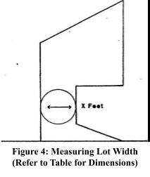
Lots with a minimum lot area of 30,000 square feet or greater shall have no more than one foot of perimeter for every 40 square feet. Lots with a minimum lot area of less than 30,000 square feet shall have no more than one foot of perimeter for every 30 square feet of lot area. In no instance shall a lot have less than 50 feet in width in any location within the lot except in a portion of the lot where two lot lines meet at a point. Any lot created before adoption of this Bylaw and conforming to then applicable requirements shall be considered a conforming lot for purposes of this Bylaw
§ 5.4Methods for Calculating Dimensional Requirements
Lot Area. Lot area shall be determined by calculating the area within a lot, excluding any area within the lot over which easements have been granted, provided that no area within a street shall be included in determining minimum lot area. When the distance between any two points on lot lines is less than 50 feet, measured in a straight line, the smaller portion of the lot which is bounded by the straight line and the lot lines shall not be considered in computing the minimum lot area unless the distance along the lot lines between the two points is less than 150 feet. (See Figure 1.)
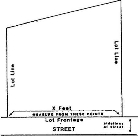
Frontage. Frontage shall be measured in a continuous line along the sideline of a street between the points of intersection of the side lot lines within the street. (See Figure 2)
Common Driveways cannot be used as part of the frontage.
Frontage that has no real and actual access from the street to each lot is illusory, and that particular lot has no frontage. Access is defined as the actual or potential provision of vehicular entry onto a lot by means of frontage on a street to a degree consistent with the use or potential use of the lot. For example, in the case of a residential lot, access shall mean that:
There is sufficient right of vehicular passage onto the lot from the street on which it has frontage and;
Vehicular passage is or may be provided between the frontage and the dwelling unit on the lot.
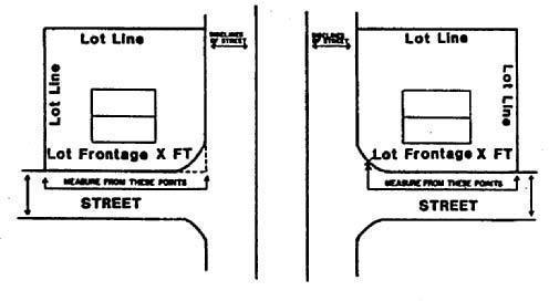
Frontage for a corner lot may be measured either to the point of intersection of the extension of the sideline of the rights of way or to the middle of the curve connecting the sideline of the intersecting streets. (See Figure 3)
Front Yards. Front yards shall be the distance measured in a straight line between the lot frontage and the nearest point of any building or structure. A lot having frontage on two or more streets shall have two or more front yards, each of which shall comply with the requirements of the front yard provisions. In no case shall any building or structure be located closer to the sideline of a street than the minimum required front yard. (See Figure 5)
Side and Rear Yards. Side and rear yards shall be the distance measured in a straight line from the nearest point of any building or structure to each side or rear lot line. (See Figure 5.)
Building Coverage. The building coverage shall be determined by dividing the total ground area of all buildings on a lot, including roof overhangs greater than 1.5 feet, carports, and canopies, whether or not the carports or canopies are part of a building, by the total lot area. Ground-mounted solar panels are not included in the calculation of building coverage, provided the area below the panel is pervious.
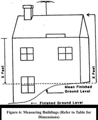
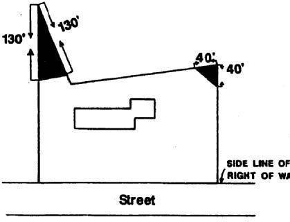
Height in Feet, Buildings. Height in feet shall be the vertical distance measured from the mean of the finished ground level adjoining the entire building at each exterior wall to the top of the highest roof beams of a flat roof or to the peak of the highest gable or slope of a hip roof. In all districts, appurtenant structures, including solar energy systems, located upon the roof of a building may extend above the height limit, but in no case shall they exceed 100 feet in height when combined with the height of the building. Appurtenant structures, exclusive of solar energy systems, in the aggregate may not occupy more than 20 percent of the roof plan area unless authorized by special permit from the Special Permit Granting Authority as designated for the particular use in Section 4.3 of this Bylaw or by the Planning Board if the principal use does not require a special permit. Roof-mounted solar energy systems are not subject to the 20 percent constraint, nor are they to be included in any calculation aggregating other roof appurtenances. (See Figure 6.)
§ 5.5Table of Standard Dimensional Requirements
| Zoning District | ||||||||
|---|---|---|---|---|---|---|---|---|
| Dimensions | R-1 | R-2 | ¹/ R-3 | B-1 | B-2 | B-3 | B-4 | I-1 |
| Minimum Lot Area (Square feet) X 1,000 | 65 | 20 | 20 | 20 | 20 | 80 | 80 | 80 |
| Minimum Lot Frontage (Lin. Feet) | 200 | 75 | 75 | 100 | 50 | 150 | 150 | 200 |
| Minimum Lot Width (Lin. Feet) | 50 | 50 | 50 | 50 | 50 | 50 | 50 | 100 |
| Minimum Front Yard (Lin. Feet) | 30 | 30 | 30 | 30 | 30 | 75 | 75 | 100 |
| Minimum Side Yard ²/ (Lin Feet) | 30 | 20 | 15 | 15 | 15 | 30 | 30 | 40 |
| Minimum Rear Yard ²/ (Lin Feet) | 30 | 20 | 15 | 15 | 15 | 40 | 40 | 40 |
| Minimum Open Space (Percent of Total Lot Area) | ³ | N/A | N/A | N/A | N/A | 25 | 25 | 25 |
| Maximum Building Height (Lin. Feet) | ⁴/36 | ⁴/36 | ⁴/36 | ⁴/36 | ⁴/36 | ⁵/40 | ⁵/40 | ⁶/45 |
Codes:
1/ Multi-family development must comply with Section 9.4 of this Bylaw. Single-family homes in the R-3 district shall require 44,000 square feet of area and 200 feet of frontage, and duplexes in the R-3 district shall require 88,000 square feet of area and 400 feet of frontage.
2/ See Section 7.4 Buffering, Screening, and Grading.
3/ See Section 9.2 Open Space Residential Development
4/ Not to exceed 2 ½ stories
5/ Not to exceed 3 stories
6/ Not to exceed 3 ½ stories
§ 5.6Reduction of Dimensional Requirements for Certain Undersized Lots
The Planning Board may, in its discretion, and by issuance of a special permit, reduce any one or more of the dimensional requirements contained in the foregoing Table of Standard Dimensional Requirements, or elsewhere in this Bylaw, for any lot in the B-1, B-2, B-3, B-4, or I-1 districts that does not satisfy the minimum lot area requirement applicable thereto. Such special permit shall require mandatory findings by the Planning Board in accordance with Section 2.7 of this Bylaw, with respect to the dimensional variation(s) proposed; and, further, shall require consideration by the Planning Board of the character of the neighborhood, the general pattern of development in the neighborhood and district, and the dimensional standards previously and generally employed in the district. Any special permit issued hereunder may be conditioned by the Planning Board in accordance with Section 2.7 of this Bylaw.
Section 6Nonconforming Uses and Structures
§ 6.1Nonconforming Lots
Existing Lots. Any lot which complied with the minimum area, frontage, and lot width requirements, if any, in effect at the time the boundaries of the lot were defined by recorded deed or plan, may be built upon or used for single-family residential use, notwithstanding the adoption of new or increased lot area, frontage or lot width requirements, provided that:
Notwithstanding the above, the separate ownership requirements identified in Paragraph 1 above which reads “the lot was held, and has continued to be held, in ownership separate from that of adjoining land,” and the requirement of 50 feet of frontage identified in Paragraph 2, shall not apply to any lot shown on any plan recorded with the Middlesex North Registry of Deeds Book before May 20, 1955, which lot abuts a lake or waterway, has not been built upon, and has been held continuously by an individual or by a trust controlled by an individual, on or before the adoption of the Tyngsborough Zoning Bylaw, May 20, 1955; and
§ 6.2Nonconforming Uses and Structures
Existing Use. Any structure or use lawfully existing at the time of the adoption of this Bylaw or any amendment hereto and any use or structure lawfully begun or in respect of which a building or special permit has been issued before the first publication of notice of public hearing on this Bylaw or any amendment hereto may be continued or completed, although the structure or use does not conform to the provisions hereof, provided that, in the case of the issuance of a building or special permit, construction or operation thereunder shall conform to the provisions of this Bylaw or any amendment hereto, unless the construction or use has commenced within a period of not more than 12 months after the issuance of the permit and that in cases involving construction, the construction is continued through to completion as continuously and expeditiously as is reasonable.
Changes, Extensions, and Alterations. A nonconforming structure or use may be changed, extended, or altered, provided that in each case, the Board of Appeals finds that the change, extension, or alteration is not substantially more detrimental or injurious to the neighborhood than the existing nonconforming structure or use.
Restoration. Restoration of a nonconforming structure, which has been damaged by fire, flood, or other casualty or by vandalism, may be made without conformance to the provisions of this Bylaw or any amendment hereto, provided that the restoration shall have commenced within 12 months of the date the damage was sustained and that the restoration continues through to completion as continuously and expeditiously as is reasonable, provided that if the cost of restoration shall exceed 50 percent of the fair market value of the structure immediately prior to the damage, as determined by the Building Inspector, the restoration shall only proceed if authorized by special permit and if the Planning Board shall find that the restoration of the structure would not:
Create a danger to public safety by reason of traffic access, flow and circulation; and
Be out of character with the traditional settlement and construction patterns of the area in which it is to be reconstructed.
§ 6.3Residential Dwellings
A single- or two-family dwelling may be altered, reconstructed, extended, or structurally changed if the alteration, reconstruction, extension, or structural change does not increase any portion(s) of the existing nonconforming nature of the structure without applying for a special permit before the Zoning Board of Appeals provided, however, any increase in the height of the structure or any increase to the non-conforming nature of the structure shall require a special permit from the Zoning Board of Appeals pursuant to the provision of G.L. c.40A, §6.
§ 6.4Abandonment
Any structure or lot, in or on which a nonconforming use is abandoned or superseded by a permitted use, shall therefore conform to the regulations for the district and the nonconforming use or structure, other than a single- or two-family dwelling, not used for a period of two years shall be deemed abandoned and shall not again be revived or the structure used, except in conformity with all applicable provisions of this Bylaw.
Section 7General Regulations
§ 7.1Parking and Loading
Objectives and Applicability
Any use of land involving the arrival, departure, or storage of motor vehicles, and all structures and uses requiring the delivery or shipment of goods as part of their function, shall be designed and operated to:
promote traffic safety by assuring adequate places for storing of motor vehicles off the street, and for their orderly access and egress to and from the public street;
increase the traffic-carrying capacity of streets and highways in the town and obtain a more efficient utilization of on-street curbside parking;
reduce hazards to pedestrians upon public sidewalks;
protect adjoining lots and the general public from nuisances and hazards such as: 1) noise, glare of headlights, dust, and fumes, resulting from the operation of motor vehicles, 2) glare and heat from parking lots, 3) a lack of visual relief from expanses of paving, 4) accelerated run-off of surface water from land covered by impervious materials.
Parking Requirements
Adequate off-street parking must be provided to service all parking demands created by new structures, additions to existing structures, or changes of use. Existing buildings and uses need not comply unless expanded or otherwise changed to increase their parking needs. Section 7.1(E) shall determine the number of spaces required except as per Section C or D below.
Exceptions to Minimum Requirement
In applying for building or occupancy permits, the applicant must demonstrate that the minimum parking requirements set forth below will be met for the new demand without counting existing parking necessary for existing uses to meet these requirements
These requirements may be reduced on Special Permit by the Special Permit Granting Authority as designated in the Table of Uses, Section 4.3 of this Bylaw for the particular use in question. If the primary use does not require a special permit, the Planning Board shall be the Special Permit Granting Authority if it finds that fewer spaces meet all parking needs. Such cases might include:
Use of a common parking lot for separate uses having peak demands occurring at different times;
Age of other characteristics of occupants which reduce their auto usage;
Peculiarities of the use which make usual measures of demand invalid.
Use of Common Parking Areas. Common parking areas may be permitted for the purpose of servicing two or more principal uses on the same or separate lots, provided that:
Evidence is submitted that parking is available within 500 feet of the premises, which lot satisfies the requirements of this Bylaw and has excess capacity during all or part of the day, which excess capacity shall be demonstrated by competent parking survey conducted by a Traffic Engineer registered in the Commonwealth of Massachusetts.
A legally binding contract, agreement, or suitable legal instrument acceptable to the Town, shall be filed with the application for building permit, occupancy permit, or special permit for exception which shall specify the location of all spaces to be jointly used, the number of spaces, the hours during the day that parking shall be available, and the duration or limit, if any, on the shared parking.
Any reduction in area required for parking because of these joint use provisions shall be reserved in landscaped open space, such area shall be computed at the rate of 400 square feet per parking space.
Nothing in this section shall relieve the owner from providing parking facilities in accordance with this Bylaw if subsequently the joint use of parking facilities shall terminate.
Number of Spaces
For the purpose of computing the parking requirements of different uses, the number of spaces required shall be the largest whole number obtained after increasing all fractions upwards to one. Employees shall include the largest number of owners, managers, full and part-time workers, and volunteers that may be normally expected on the premises during any single shift or portion thereof. The number of seats in benches, pews, or other continuous seating arrangements shall be calculated at twenty inches for each seat. The following minimum parking requirements shall apply to uses as listed in the Table of Off-Street Parking Requirements, Section 7.1(F).
Table of Off-Street Parking Requirements
| Use | Number of Spaces |
|---|---|
| Stores, Retail Business, and Services | One space per 200 square feet of gross leasable area or a minimum of at least three spaces per establishment |
| Banks, Libraries, and Post Offices | One space per 100 square feet of floor area devoted to public use, plus one space per employee |
| Bowling Alleys | Four spaces for each alley |
| Business and Professional Offices, Office Buildings, and Office of a Wholesale Establishment including Sales Space | One space per 200 square feet of gross floor area |
| Medical and Dental Offices and Clinics | One space per 200 square feet of gross floor area |
| Restaurants, Lounges, and Function Rooms | One space per three seats based on the legal seating capacity of the facility |
| Fast Food Establishment | One space per 50 square feet of gross floor area |
| Craft Brewery or Distillery | 1 space per 1.4 employees plus 1 space per 200 s.f. of retail area. |
| Craft Brewery & Taproom | 1 space per 1.4 employees plus 3 spaces per 10 occupants based on rated seating capacity. |
| Theater, Funeral Home, and Places of Assembly | One space for each four seats or for each 50 square feet of assembly area |
| Hotels, Motels, and Tourist Homes | One space per guest room, plus one space per employee, plus a number of spaces as required elsewhere for restaurants, assembly halls, function rooms, shops, and similar functions if occurring on the premises |
| Non-family Accommodation | One space per two persons accommodated |
| Nursing and Convalescent Homes | One space for each three beds plus one space for each employee serving on the shift having the greatest number of employees, plus one space for each visiting staff |
| Clubs, Lodges, and Association Buildings | One space per three memberships |
| Lumber and Building Material Yards, Nurseries, and Outdoor Sales | One space per 150 square feet of office and indoor sales area and/or one space per 1,000 square feet of outdoor sales area |
| Manufacturing, Truck Terminals, Wholesale Establishments, Public Utility Buildings other than their Business Offices, warehouses, and similar uses not normally visited by the general public | One space per 1.4 employees plus one space for each vehicle used in the operation |
| Mini-Warehouse / Self-Storage | For single-level, direct-access self-storage, a minimum of 4 spaces should be located at the leasing office and a minimum of 1 space per 2 units located throughout the lanes. For indoor, multi-level self-storage, a minimum of 4 spaces should be located at the leasing office plus 1 parking space per 75 units. A loading bay shall count as a parking space. |
| Any other non-residential use, or any use involving a combination of functions similar to or listed herein | A number of spaces as determined by the Building Inspector by application of the ratios above or by the Special Permit Granting Authority if use requires a special permit |
| Single-family, Two-family, and Multi-family Dwelling | Two spaces per dwelling unit for units with two or more bedrooms, one space per dwelling units for others |
| Home Occupation | In addition to the spaces required for the dwelling, one space per non-resident employee, plus a number of spaces sufficient to satisfy the requirements of Section 3.10.10 |
Loading Areas.
All buildings requiring the delivery of goods, supplies, or materials, or shipment of the same, shall have bays and suitable maneuvering space for off-street loading of vehicles in accordance with this Section 7.1(G).
Table of Loading Requirements
| Use | Number of Berths |
|---|---|
| Retail Stores and Services | For each establishment with a gross floor area from 5,000 to 8,000 square feet, at least one berth. Additional space is required at the rate of one berth per 8,000 square feet or nearest multiple thereof. Where two or more establishments are connected by a common wall such as in a shopping center, common berths may be permitted for the use of all establishments at the rate of one berth space per 8,000 square feet in the entire shopping center. |
| Office Buildings | For each office building with gross area of 4,000 square feet or more, at least one berth shall be provided. |
| Manufacturing, Industrial Warehousing | For manufacturing, industrial and warehousing and similar uses up to 8,000 square feet of gross floor area, at least one berth shall be provided. For larger floor areas, additional berths shall be provided as required by the Building Inspector adequate for off-street loading and unloading. |
Parking and Loading Area Design and Location
General Standards.
No off-street parking shall be located within 15 feet of a street right-of-way, or in any required buffer zone adjacent to a residential or institutional use.
Parking spaces more than 500 feet from the building entrance they serve may not be counted towards fulfillment of parking requirements unless the Special Permit Granting Authority as per Section 7.1(C) determines that circumstances justify this greater separation of parking from use.
All required parking areas except those serving single-family residences shall be paved, unless exempted by Special Permit for cases such as seasonal or periodic use where unpaved surfaces will not cause dust, erosion, hazard, or unsightly conditions.
Parking areas for five or more cars shall not require vehicles to back onto a public way. The following shall apply to entrances or exits to all parking areas having 20 or more spaces:
Entrance or exit center lines shall not fall within 50 feet of an intersection of street sidelines or within 150 feet of the centerline of any other parking area entrance or exit on the same side of the street, whether on the same parcel or not, if serving 20 or more spaces. Users shall arrange for shared egress if necessary to meet these requirements.
Egressing vehicles shall have 400 feet line of sight visibility in each travel direction as measured four feet above the pavement.
Such parking lots shall contain or be bordered within five feet by at least one tree per eight parking spaces, trees to be of two-inch caliper or larger, with not less than 40 square feet of unpaved soil area per tree. Trees and soil plots shall be located so as to assure safe internal circulation and to provide visual screening from streets and residential areas. These planting requirements may be waived if solar canopies are installed over parking spaces.
Street entrances shall be designed consistent with Massachusetts DPW Traffic Regulations, Section 10A-9 or any subsequent revisions.
Continuous curbing shall be provided to control access and damage, and wheel stops shall be provided for all other parking areas of five or more vehicles. Loading areas and parking areas for 20 or more cars shall provide screening and landscaping in accordance with Section 7.1(H)(9) of this Bylaw.
Parking Dimensions. On any lot, in any district, with the exception of single- and two-family dwelling use, parking spaces and maneuvering aisles shall have the minimum dimensions as set forth in the following table.
| Minimum Parking Stall Dimensions (in feet) | |||
|---|---|---|---|
| Angle of Parking | Width | Depth | Width of Maneuvering Aisle |
| Standard | |||
| 45'-90' | 10 | 20 | 22 |
| Parallel | 9 | 22 | 15 |
| Compact | |||
| 45'-90' | 9 | 16 | 24 |
| Parallel | 8 | 18 | 15 |
| Handicapped | |||
| 45'-90' | 10 | 20 | 24 |
| Parallel | 10 | 22 | 15 |
Compact Spaces. Office uses, research/office parks, and manufacturing facilities which contain at least 40,000 square feet of gross floor area, 30 percent of the required parking may be in stalls for compact cars in accordance with the dimensional requirements as set forth in Paragraph 2 above.
Handicapped Parking. Parking spaces designated for the exclusive use of handicapped individuals shall be provided in accordance with the most recent rules and regulations of the Architectural Barriers Board of the Commonwealth of Massachusetts and shall conform to the dimensional requirements of the Board or Paragraph 2 above, whichever is greater.
Loading Area Dimensions. All required loading bays shall have minimum dimensions as follows: 30 feet long, 12 feet wide, and 14 feet high. Each loading bay shall have a maneuvering space equal to its length. Where the long portion of a loading bay abuts a wall, column, or other obstacle, or in other cases where the Building Inspector or the Special Permit Granting Authority requests, evidence shall be provided that the loading bay and its maneuvering space is adequate to accommodate large motor vehicles, and trailers.
Marking. In a parking lot or loading area, the surface of the parking lot or loading area shall be painted, marked, or otherwise delineated so that the location of the parking spaces and loading bays is apparent. Where 5 percent or more of the required parking spaces in a parking lot are assigned, such as to individual employees or to dwelling units in a multi-family building, parking spaces for guests or visitors to the use or establishment, not to exceed percent of the required parking spaces, shall be located and designated as visitor parking near the principal entrance to the building which it serves.
Availability and Snow Storage. To ensure the availability and utilization of required parking spaces and loading bays on a year-round basis:
No fee or other charge to the parker, in addition to a lease or purchase agreement applicable to occupants generally, shall be made for a parking space or loading bay required to serve a use, building, or establishment.
A strip of land not less than five feet in width shall be provided on at least two sides of a parking lot or loading area and designated on the off-street parking and loading plan for the storage of snow plowed or removed from the surface area of the parking lot or loading area. The snow storage area may not encroach on the area required for off-street parking or loading but may be located in the landscaped open area or in the area of required setback from a lot line or building.
Each required off-street parking space and loading bay shall be designed so that any motor vehicle may proceed to and from the space without requiring the moving of any other vehicle or by passing over any other space or bay.
Parking spaces for vehicles larger than automobiles, such as large trucks or buses, shall be specifically identified on the off-street parking and loading plan and shall be of adequate dimensions as to accommodate the specified type of vehicle. Larger vehicles shall be permitted to park only in the spaces so identified and approved.
Surfacing, Drainage, and Grade.
All required parking spaces and loading bays, maneuvering aisles, and driveways shall have a durable, dustless, all-weather surface suitable for year-round use, such as asphalt or concrete, and shall dispose of surface water by grading and drainage in such a manner that no surface water shall drain onto any public way or onto any lot in other ownership.
It is the intent of this section that the paved surface of a parking lot or loading area shall be limited to areas necessary for the parking spaces, loading bays, maneuvering aisles, and driveways required to meet the provisions of this section. The site plan, if required by this Bylaw, shall demonstrate that all paved areas associated with a parking lot are necessary for the storing, standing, or maneuvering of vehicles; the Special Permit Granting Authority, as per Section 7.1(C) of this Bylaw, may deny the request for a Special Permit when more area is to be paved than is necessary to comply with the provisions of this section.
The maximum grade of any required maneuvering aisle, parking space, or loading bay shall be eight percent. The maximum grade of any outdoor driveway shall be ten percent.
Landscaping
On at least three sides of the perimeter of an outdoor parking lot containing 20 or more parking spaces, there shall be planted at least one tree for every eight parking spaces abutting the perimeter. The trees shall be spaced so that some part of a parking space is not more than 30 feet from a tree.
In the interior part of an outdoor parking lot where two rows of parking spaces containing a total of ten or more parking spaces face each other, a landscaped open space not less than five feet in width shall be provided. The landscaped strip may be provided either: 1) between the rows of parking spaces parallel to the aisle or, 2) in two or more strips parallel to the spaces and extending from the aisle serving one row of spaces to the aisle serving the other row of spaces. There shall be planted in each strip at least three trees and in all strips not less than one tree for every eight parking spaces in the interior part of the parking lot. Trees shall be spaced so that some part of a parking space is not more than 30 feet from a tree.
Trees required by this section shall be at least two inches in diameter at a height four feet above the ground at time of planting and shall be of a species characterized
by suitability and hardiness for location in a parking lot. To the extent practicable, existing trees shall be retained and used to satisfy this section.
The Planning Board may use its site-plan review process to waive some or all of these landscaping requirements to facilitate the effective installation of solar canopies over parking areas.
§ 7.2Signs
Purpose. The purpose of this section is to regulate the effective use of signs as a means of communication in the Town; to maintain and enhance the aesthetic environment and the Towns’ ability to attract sources of economic development and growth; to maintain pedestrian and traffic safety; to minimize the possible adverse effect of signs on nearby public and private property; and to enable the fair and consistent enforcement of these sign restrictions. This sign bylaw is adopted under the zoning authority of the Town in furtherance of the more general purpose set forth in this Bylaw.
Exceptions: The following shall not be considered signs within the context of this Bylaw:
Flags and insignia of any government, except when displayed in connection with commercial promotion;
Legal notices or informational devices erected or required by public agencies, with the exception of Electronic Message Center signs as provided for in Section 7.2.I and 7.2.J.
Standard gasoline pumps bearing thereon in usual size and form the name, type, and price of the gasoline or similar automobile fuel products;
Integral decorative or architectural features on buildings, except that letters, trademarks, moving parts, or parts internally illuminated or decorated with gaseous tubing or other lights shall be considered signs;
On-premise devices and incidental signs guiding and directing traffic and parking, not exceeding two square feet in area, and bearing no advertising;
Dial-faced clocks, either unlighted or internally lit, bearing no advertising.
General Provisions
Permits. No sign shall be erected, enlarged, or structurally altered without a sign permit issued by the Building Commissioner or other appropriate authority as specified in this bylaw unless specifically exempted from this requirement. Permits shall only be issued for signs in conformance with this bylaw. Permit applications must be accompanied by two prints of scale drawings of the sign, supporting structure, and the location. A copy of any relevant Special Permit issued under Section 2.7 of this Bylaw shall also accompany the application. All freestanding or roof signs shall be registered and identified as required by the State Building Code 780 CMR Chapter 31, as amended. All applications must be accompanied by the appropriate fees.
Maintenance. All signs shall be kept in a safe condition and maintained in accordance with the State Building Code 780 CMR Chapter 31, as amended.
Nonconformance. Any nonconforming sign legally erected prior to the adoption of this provision, or any amendments hereto, may be continued and maintained. Any signs rendered nonconforming through change or termination of activities on the premises shall be removed within thirty days of order by the Building Commissioner. No existing sign shall be enlarged, redesigned, or altered in any way unless it conforms to the provisions contained herein. Any sign which has been destroyed or damaged to the extent that the cost to restore or repair will exceed one third of the replacement value as of the date of destruction shall not be repaired, rebuilt, restored, or altered unless in conformity with this bylaw.
Prohibitions
No sign shall be lighted, except by a steady, stationary light, shielded and directed solely at or internal to the sign, with the exception of Electronic Message Center signs as provided for in Section 7.2.I and 7.2.J. Use of neon or other gaseous elements is prohibited except as allowed under specific district regulations.
No illumination which casts glare onto any residential premises or onto any portion of a way so as to create a traffic hazard shall be permitted. All determinations on traffic hazards shall be made by the Chief of Police.
No sign shall be illuminated in any residential district between the hours of 11:00 P.M. and 7:00 A.M. unless the establishment is legally open to the public during those hours.
No sign having red or green lights shall be erected within sight of a traffic signal unless approved as non-hazardous by the Chief of Police.
No animated, revolving, or flashing sign shall be permitted, with the exception of Electronic Message Center signs as provided for in Section 7.2.I and 7.2J.
No pennants, streamers, advertising flags, spinners, or similar devices shall be permitted, except as allowed by a sign permit from the Select Board.
No signs shall be attached to any motor vehicles, trailers, or movable objects such as portable signs, regularly or recurrently located for fixed display.
Corner visibility shall not be obstructed in such a manner that will create a traffic hazard. All determinations of traffic hazards shall be made by the Chief of Police.
Billboards, as defined in Section 11 Definitions, are prohibited in all zoning districts.
Off-Premises Signs. Only signs pertaining exclusively to the premises on which they are located or to products, accommodations, services, or activities on the premises shall be allowed with the following exceptions:
One off-premise directional sign designating the route to an establishment not on the street to which the sign is oriented may be erected and maintained on a free-standing pole within the public right-of-way at any intersection if authorized with a sign permit from the Select Board, or on private property if granted a Special Permit by the Board of Appeals.
An off-premise sign shall be authorized only upon the authorizing agency’s determination that it will promote the public interest and will not endanger the public safety.
In locations where directions to more than one establishment are to be provided, all directional information shall be incorporated into a single pole. The pole shall be no more than eight feet above the road surface and may be shared by a maximum of six businesses.
All directional signs shall be unlighted and shall only bear the name of a business, distance, and directional arrow.
Each sign shall be six inches by 24 inches and shall have a dark blue background with white lettering.
Sign poles and locations will be subject to the approval of the Building Commissioner and the Highway Department Supervisor.
Temporary signs without commercial advertising that advertise local sales or special events of a public, charitable, or religious organization may be erected at town-designated sign kiosks if authorized with a sign permit by the Select Board.
Temporary Signs. Temporary signs shall be allowed provided they comply with the following general requirements and the specific requirements for the zoning districts:
Unless otherwise specified in this bylaw, temporary signs must comply with all applicable requirements for permanent signs, including issuance of a sign permit.
Temporary signs not meeting requirements for permanent signs may advertise sales, special events, or changes in the nature of an operation if allowed by a sign permit from the Select Board. Such signs shall not be used to advertise a continuing or regularly recurring business operation and shall be removed promptly when the information they display is out of date, no longer relevant, or within 45 days of the sign permit date, whichever is the earliest.
Political signs shall be allowed only on private property.
Fee Schedule. All fees for all sign permits will be reviewed and assigned annually by the Select Board.
| 7.2H OFF-PREMISE SIGNS | |||||
|---|---|---|---|---|---|
| GENERAL SIGN REQUIREMENTS | |||||
| Only signs pertaining exclusively to the premises on which they are located or to products, accommodations, services, or activities on the premises shall be allowed except for the exclusions in this Section 7.2H. Off-premise signs permitted by this Section shall be allowed in every Zoning District subject to the requirements and conditions in this Section 7.2H. | |||||
| Directional Signs | |||||
| Number | One off-premises directional sign designating the route to an establishment, not located on the street to which the sign is oriented, may be erected and maintained on a free-standing pole within the public right-of-way at any intersection, subject to the permit requirements listed below. | ||||
| Maximum Size | 6 inches by 24 inches | ||||
| Maximum Height | The sign pole shall not be more than 8 feet above the ground level. | ||||
| Location | Sign poles and location are subject to the approval of the Building Commissioner and the Superintendent of Public Works. | ||||
| Standards | ● An off-premise sign shall be authorized only upon the authorizing agency’s determination that it will promote the public interest and will not endanger the public safety. ● In locations where directions to more than one establishment are to be provided, all directional information shall be incorporated into a single pole. The pole shall be no more than eight feet above the road surface and may be shared by a maximum of six businesses. ● All directional signs shall be unlighted and shall only bear the name of a business, distance, and directional arrow. | ||||
| Permit Requirement | If located within a public right-of-way, a Sign Permit from the Select Board is required. If located on private property, a Special Permit from the Zoning Board of Appeals is required. | ||||
| Local Sales and Public Event Signs | |||||
| Number | To be determined by the Select Board | ||||
| Maximum Size | |||||
| Maximum Height | |||||
| Location | The sign may be erected on Town-owned designated sign kiosks. | ||||
| Standards | ● The signs shall be limited to advertising local sales or special events of a public, charitable, or religious organizations. ● The signs shall not contain commercial advertising. | ||||
| Permit Requirement | Signs shall only be authorized by the issuance of a Sign Permit by the Select Board. | ||||
| 7.2I RESIDENTIAL ZONING DISTRICTS | |||||
|---|---|---|---|---|---|
| R-1 Low Density Residential District; R-2 Moderate Density Residential District R-3 Multi-family Residential District | |||||
| GENERAL SIGN REQUIREMENTS | |||||
| ● Sign are permitted in the Residential Districts are also permitted in the Business Districts and the Industrial District unless specifically classified in a different manner in the individual Business Districts. ● No part of any sign shall be located within 10 feet of any property line unless attached to a building. | |||||
| PERMANENT SIGNS | |||||
| Sign Type | Maximum Number | Maximum Size | Location | Standards | Permit Requirement |
| Name of Owner or Occupant and Street Number | 1 | 2 square feet | Attached or free-standing | Not required | |
| Sign pertaining to a permitted nonresidential principal use of the premises | 1 | 12 square feet | Attached or free-standing | Oriented to the primary street on which the premises has frontage or access. | Sign Permit |
| Name of residential subdivision, apartments, condominiums, or similar residential use | 1 | 12 square feet | Sign Permit | ||
| Ballfield, arena, stadium sign | 12 square feet | Fences or walls oriented to be viewed from the inside or playing portion of the field or arena. | ● Maximum sign coverage of fences or wall area where the signs are attached shall be 50%. Signs shall be unlighted | Not required, but written notice shall be submitted to Building Commissioner. | |
| Home occupation sign | 1 | 2 square feet | See Section 4.4 | Sign Permit | |
| “Open” or holiday decorative flag | 2/residence or business | 12 square feet each | Not required unless the flag is an advertising flag as determined by the Building Commissioner. | ||
| ELECTRONIC MESSAGE CENTER SIGNS (EMC) – EDUCATIONAL AND MUNICIPAL USES ONLY | |||||
| Location | ● EMCs shall be permitted only for the following uses in all Residential Zoning Districts: Educational Institutions and Municipal Uses, subject to the standards listed below. EMCs shall be prohibited for all other uses. ● EMCs shall not be located closer than 10 feet to the front property line. | ||||
| Number | 1/use | ||||
| Maximum Size | 32 sq. ft. | ||||
| Maximum Height | 8 feet above ground level | ||||
| Standards | ● EMC signs shall not create any safety hazards based on the sign’s location or position and its effect on traffic patterns, traffic lights, or public safety. ● The following illumination standards shall apply to the EMC sign: a) There shall be no safety hazards created based on the sign’s illumination effect on traffic patterns, traffic lights, or public safety. b) No sign shall exceed 7,500 nits (nit is the industry standard of luminosity measurement of one candela per square meter) and the sign shall be accompanied by a manufacturer’s certificate to that effect. c) Each sign shall have a photocell sensor that automatically adjusts brightness according to ambient light conditions and include settings to reduce the brightness to 10% or less of the maximum setting at night. d) Each sign must include a factory override to adjust the nighttime brightness to less than10% if necessary. e) Each sign shall be equipped with a default design or message that will be displayed in the event that a malfunction occurs. ● The messages be displayed for a period of at least 10 seconds. ● The messages displayed shall be static and the transition from one static display to another static display shall be instantaneous to the human eye without having any transition effects. ● EMC signs shall not be lighted or operating between the hours of 10:00 pm and 6:00 am. ● Signs shall meet the definition of EMC signs located under the “Sign” subsection of Section 11 DEFINITIONS. | ||||
| Permit Requirements | Sign permit | ||||
| TEMPORARY SIGNS (SEE SECTION 7.2E) | |||||
| Sign Type | Maximum Number | Maximum Size | Location | Standards | Permit Requirement |
| Construction sign | 1 | 25 square feet | ● Unlighted ● Indicates name and address of parties involved in the construction on the premises. | Sign Permit required unless the sign is not more than 12 square feet and the sign shall be removed within 45 days of installation. | |
| Real Estate sign | 1 | 6 square feet | Sign Permit required unless written notice is provided to the Building Commissioner that the sign will be removed within 45 days of installation. | ||
| 7.2J BUSINESS DISTRICTS & INDUSTRIAL DISTRICT | |||||
|---|---|---|---|---|---|
| Requirements | B-1 Neighborhood Business District | B-2 Office -Professional Business District | B-3 General Shopping Business District | B-4 Adult Business District | I-1 Industrial Uses District |
| GENERAL SIGN REQUIREMENTS | |||||
| ● Sign are permitted in the Residential Districts are also permitted in the Business Districts and the Industrial District unless specifically classified in the individual Business Districts. ● No part of any sign shall be located within 10 feet of any property line unless attached to a building. ● In the Business 3 (B-3) District and the Industrial 1 (I-1) District, the Zoning Board of Appeals may authorize, by issuance of a Special Permit, up to one additional attached sign and/or up to 30% increase in the maximum square footage of attached sign(s) beyond what is otherwise permitted in Section 7.2; provided however that the Zoning Board of Appeals finds that the variation in number or size is not incongruous with the applicable zoning district nor injurious to traffic and safety conditions. | |||||
| PERMANENT SIGNS | |||||
| Attached Signs | |||||
| Number | 1/business | 1/business | 1/business | 1/business | 1/business |
| Maximum Size | 12 square feet | 25 square feet | 100 square feet | 100 square feet | 200 square feet |
| Location | Attached flat against the wall or fixed canopy of the building or projecting from it | Same as B-1 District | Same as B-1 District | Same as B-1 District | Attached flat against the wall or fixed canopy of the building. |
| Standards | Oriented to the street on which the premises has frontage or access. The area of sign for any occupant shall not exceed 20 percent of the portion of the wall area assigned to the occupant up to the maximum 12 square feet. One projecting sign of not more than 12 square feet may be used in lieu of a wall sign. Individual unlighted window signs not exceeding 2 square feet and identifying the occupant therein shall be excluded from the above requirements. In the Business 3 (B-3) District only, a business located such that the front wall of the portion of the building where the business is located faces one street and the side wall of its building where the building is located faces a second street, shall be allowed a second attached sign on the building side wall with a maximum size of 100 square feet. | ● Oriented to the street on which the premises has frontage or access. Roof signs projecting no more than 6 feet above a wall may be used in lieu of the attached sign area. | |||
| Permit Requirements | Sign Permit | Sign Permit | Sign Permit | Sign Permit | Sign Permit |
| Attached Signs Abutting Limited Access, High-Speed Highways | |||||
| Special Permit | The Select Board may grant a special permit for an additional attached sign on a building abutting a limited access highway or high-speed highway. The sign shall be limited to the name of the principal building tenant. | ||||
| Freestanding Signs | |||||
| Number | 1 sign per each street on which the premises have access | ||||
| Maximum Size | 25 square feet | ||||
| Maximum Height | 8 feet above ground level | ||||
| Location | |||||
| Standards | Sign shall only contain the name of the firms or services available or produced on the premises | ||||
| Permit Requirements | Sign Permit | ||||
| Freestanding Signs – Single Business on a Lot | |||||
| Number | 1 | 1 | 1 | 1 | |
| Maximum Size | 12 square feet | 25 square feet | 25 square feet | 25 square feet | |
| Maximum Height | 8 feet above ground level | 8 feet above ground level | 8 feet above ground level | 8 feet above ground level | |
| Location | On same lot where business is located. | On same lot where business is located. | On same lot where business is located. | On same lot where business is located. | |
| Standards | Zoning Board of Appeals may allow a sign of no more than 50 square feet and 25 feet above ground level if it determines the sign will not be incongruous with the B-1 District nor injurious to traffic and safety conditions. | Zoning Board of Appeals may allow a sign of no more than 50 square feet and 25 feet in height if it determines the sign will not be incongruous with the B-3 District nor injurious to traffic and safety conditions. | Zoning Board of Appeals may allow a sign of no more than 50 square feet and 25 feet in height if it determines the sign will not be incongruous with the B-4 District nor injurious to traffic and safety conditions. | ||
| Permit Requirements | Sign Permit | Sign Permit | Sign Permit | Sign Permit | |
| Freestanding Signs – Retail Complex of 50,000 square feet or More of Floor Area, with Three or More Businesses | |||||
| Number | 1/lot | 1/lot | |||
| Maximum Size | 100 square feet | 100 square feet | |||
| Maximum Height | 25 feet above ground level | 25 feet above ground level | |||
| Location | Located on a single lot. | Located on a single lot. | |||
| Standards | ● Oriented to the street on which the premises have frontage or access. ● Sign shall only contain the name of the complex and the names of businesses or occupants within the complex. | ● Oriented to the street on which the premises have frontage or access. ● Sign shall only contain the name of the complex and the names of businesses or occupants within the complex. | |||
| Permit Requirements | Sign Permit | Sign Permit | |||
| Freestanding Signs – Retail Complex (Shopping Center or Mall of 150.000 square feet or more of Floor Area on a Single Lot | |||||
| Number | 1/lot | 1/lot | |||
| Maximum Size | 300 Square feet | 300 square feet | |||
| Maximum Height | 25 feet above ground level | 25 feet above ground level | |||
| Location | Oriented to the street on which the premises have frontage or access. | ||||
| Standards | ● Signs shall only contain the name of the complex and the businesses or occupant within the complex. ● Where one occupant of the complex is a multiple x theater, the sign may include the theater’s current billings. | ● Signs shall only contain the name of the complex and the businesses or occupant within the complex. ● Where one occupant of the complex is a multiple x theater, the sign may include the theater’s current billings. | |||
| Permit Requirements | Sign Permit | Sign Permit | |||
| Multiple Business Signs | |||||
| Number | 1/business | 1/business | 1/business | 1/business | |
| Maximum Size | ● 20% of wall area if attached ● 25 sq. ft. if free-standing | ● 20% of wall area if attached ● 25 sq. ft. if free-standing | ● 20% of wall area if attached ● 25 sq. ft. if free-standing | ● 20% of wall area if attached ● 25 sq. ft. if free-standing | |
| Maximum Height | 8 feet above ground level | 8 feet above ground level | 8 feet above ground level | 8 feet above ground level | |
| Location | On same lot where business is located | On same lot where business is located | On same lot where business is located | On same lot where business is located | |
| Standards | ● Sign shall identify the businesses or occupants of the premises. ● Zoning Board of appeals may allow a sign of no more than 50 square feet and 25 feet in height if it determines the sign will not be incongruous with the B-1 District nor injurious to traffic and safety conditions. | ● Sign shall identify the businesses or occupants of the premises. | ● Sign shall identify the businesses or occupants of the premises. ● Zoning Board of appeals may allow a sign of no more than 50 square feet and 25 feet in height if it determines the sign will not be incongruous with the B-3 District nor injurious to traffic and safety conditions. | ● Sign shall identify the businesses or occupants of the premises. ● Zoning Board of appeals may allow a sign of no more than 50 square feet and 25 feet in height if it determines the sign will not be incongruous with the B-4 District nor injurious to traffic and safety conditions. | |
| Permit Requirements | Sign Permit | Sign Permit | Sign Permit | Sign Permit | |
| Electronic Message Center Signs (EMC) – Educational Institutions and Municipal Uses only | |||||
| Location | ● EMCs shall be permitted only for the following uses in all Business and Industrial Zoning Districts: Educational Institutions and Municipal Uses, subject to the standards listed below. EMCs shall be prohibited for all other uses. ● They shall not be located closer than 10 feet to the front property line. | ||||
| Number | 1/use | 1/use | 1/use | 1/use | 1/use |
| Maximum Size | 32 sq. ft. | ||||
| Maximum Height | 8 feet above ground level | ||||
| Standards | ● EMC signs shall not create any safety hazards based on the sign’s location or position and its effect on traffic patterns, traffic lights, or public safety. ● The following illumination standards shall apply to the EMC sign: a) There shall be no safety hazards created based on the sign’s illumination effect on traffic patterns, traffic lights, or public safety. b) No sign shall exceed 7,500 nits (nit is the industry standard of luminosity measurement of one candela per square meter) and the sign shall be accompanied by a manufacturer’s certificate to that effect. c) Each sign shall have a photocell sensor that automatically adjusts brightness according to ambient light conditions and include settings to reduce the brightness to 10% or less of the maximum setting at night. d) Each sign must include a factory override to adjust the nighttime brightness to less than10% if necessary. e) Each sign shall be equipped with a default design or message that will be displayed in the event that a malfunction occurs. ● The messages be displayed for a period of at least 10 seconds. ● The messages displayed shall be static and the transition from one static display to another static display shall be instantaneous to the human eye without having any transition effects. ● EMC signs shall not be lighted or operating between the hours of 10:00 pm and 6:00 am. ● Signs shall meet the definition of EMC signs located under the “Sign” subsection of Section 11 DEFINITIONS. | ||||
| Permit Requirements | Sign Permit | Sign Permit | Sign Permit | Sign Permit | Sign Permit |
| Internally Lit Window Signs | |||||
| Number | 1 per business or occupant | Prohibited | 1 per business or occupant | 1 per business or occupant | Prohibited |
| Maximum Size | 6 square feet | 6 square feet | 6 square feet | ||
| Location | Window | Window | Window | ||
| Standards | Neon sign is allowed | Neon sign is allowed | Neon sign is allowed | ||
| Permit Requirements | Sign Permit | Sign Permit | Sign Permit | ||
| Business “Open” or Holiday Decorative Flag Sign | |||||
| Number | 2 per residence or business | 2 per residence or business | 2 per residence or business | 2 per residence or business | 2 per residence or business |
| Maximum Size | 12 square feet each | 12 square feet each | 12 square feet each | 12 square feet each | 12 square feet each |
| Maximum Height | |||||
| Location | |||||
| Standards | |||||
| Permit Requirements | Not required unless the flag is an advertising flag as determined by the Building Commissioner | ||||
| Office/Industrial Development Lot Subdivision Identification Sign | |||||
| Number | Prohibited | 1 | 1 | 1 | 1 |
| Maximum Size | 25 square feet | 25 square feet | 25 square feet | 25 square feet | |
| Maximum Height | 8 feet above ground level | 8 feet above ground level | 8 feet above ground level | 8 feet above ground level | |
| Location | Signs shall be oriented to the primary street on which the premises have access. | Signs shall be oriented to the primary street on which the premises have access. | Signs shall be oriented to the primary street on which the premises have access. | Signs shall be oriented to the primary street on which the premises have access. | |
| Standards | |||||
| Permit Requirements | Sign Permit | Sign Permit | Sign Permit | Sign Permit | |
| Local Sales and Public Event Signs | |||||
| Number | To be determined by the Select Board | ||||
| Maximum Size | |||||
| Maximum Height | |||||
| Location | The sign may be erected on Town-owned designated sign kiosks. | ||||
| Standards | ● The signs shall be limited to advertising local sales or special events of a public, charitable, or religious organizations. ● The signs shall not contain commercial advertising. | ||||
| Permit Requirement | Signs shall only be authorized by the issuance of a sign permit by the Select Board. | ||||
| TEMPORARY SIGNS (SEE SECTION 7.2E) | |||||
| Unlighted Window Sign | |||||
| Number | |||||
| Maximum Size | Shall not occupy more than 30% of the glass area of the window | Shall not occupy more than 30% of the glass area of the window | Shall not occupy more than 30% of the glass area of the window | Shall not occupy more than 30% of the glass area of the window | |
| Maximum Height | |||||
| Location | Window | Window | Window | Window | |
| Standards | |||||
| Permit Requirements | No permit required | No permit required | No permit required | No permit required | |
| Unlighted Real Estate Sign | |||||
| Number | 1 | 1 | 1 | 1 | 1 |
| Maximum Size | 25 square feet | 12 square feet | 25 square feet | 25 square feet | 25 square feet |
| Maximum Height | 8 feet above the ground level | ||||
| Location | Setback a minimum of 10 feet from the front property line. | ||||
| Standards | For advertising the sale, rental, or lease of the premises or subdivision on which the sign is erected. | ||||
| Permit Requirements | Permit required unless written notice is provided to the Building Commissioner that the sign will be removed within 45 days of installation. | ||||
Submittals Generally. The applicant for a special permit as required under this section shall submit appropriate materials as per the regulations adopted by the Select Board pursuant to Section 2.7 of this Bylaw.
Decision Criteria. A special permit for a sign pursuant to this section shall be approved only upon determination of the Select Board that the requirements of Section 2.7 Special Permits including Section 2.7(F) Mandatory Findings of Special Permit Granting Authority and the following additional criteria:
Efficient Communication
Signs should not contain selling slogans or other advertising that is not an integral part of the name or other identification of the occupant.
Sign letter size should be related to the reader’s distance and speed.
Signs should be simple and avoid distracting elements so that the contents can be read quickly and easily.
Environmental Relationship
Projecting signs shall be used only in locations such as on side streets where projecting position is necessary for visibility from the roadway.
Building Relationship
Signs should be sized and located so as to not interrupt, obscure, or hide the continuity of columns, cornices, roof eaves, sill lines, or other elements of the building structural form.
§ 7.3Outdoor Lighting
In the area of new construction in the B-1, B-2, B-3, and I-1 zones, outdoor lighting including lighting on the exterior of a building or lighting in parking areas, shall be arranged to minimize glare and light spilling over the neighboring properties. Except for low level intensity pedestrian lighting shall be designed and located so that:
The luminaire has an angle of cutoff less than 76 degrees;
A line drawn from the height of the luminaire along the angle of cutoff intersects the ground at a point within the development site;
The bare light bulb, lamp, or light source is completely shielded from direct view at any point five feet above the ground on neighboring properties or streets.
§ 7.4Buffering, Screening, and Grading
Purposes. The purpose of the provisions of this section is to protect against potential noxious, visual, or descriptive effects of adjacent land uses of differing character and intensity; prevent the intrusion upon residential areas of these effects; and limit the deleterious effects of erosion. Use of existing natural wooded landscape is encouraged and is meant to be augmented with the following.
Buffering and Screening From Adjacent Residential Uses. Buffer areas shall be provided in all areas where any land use not of a residential nature, located in any commercial or industrial zone adjoins a residential district or an existing residential use within the same district along its side or rear lot line.
Buffering and Screening Requirements in B-3, B-4, and I-1 Districts. Where a side or rear lot line of a development in a B-3, B-4, or I-l district adjoins a residential district or an existing residential use within the same district, the following buffer requirements shall apply:
A strip of land not less than 50 feet from the side or rear lot lines shall be provided. This requirement may be reduced to 25 feet by the Planning Board where alternative designs such as that required by Paragraph d below meet the intent of this section.
Such strip shall contain a continuous screen of planting of vertical habit in the center of the strip not less than three feet in width and six feet in height at the time of occupancy so as to maintain a dense screen year-round.
At least 50 percent of the plantings shall consist of evergreens and shall be evenly spaced along the length of the buffer strip.
In lieu of continuous planting, a solid brick, stone, or wood fence of a design approved by the Planning Board, not less than six feet nor more than eight feet in height, or a planted earthen berm of a design approved by the Planning Board may be established and maintained with plantings in an amount no less than 20 percent of the amount required in Paragraphs b and c above.
Buffering and Screening Requirements in B-1 and B-2 Districts. The buffering requirements in B-1 and B-2 zones shall be as stated in Section 7.2(B) above with the following exceptions
The width of the buffer between residential and business-related land uses in the B-1 zone shall be 20 feet.
The width of the buffer between residential and business-related land uses in the B-2 zone shall be 10 feet.
Buffering and Screening Requirements Between Land Uses in Business and Industrial Zones. In all cases, business and commercial land uses shall have a buffer area between each commercial or industrial lot that extends from the front line to the rear lot line and a buffer extending inward from the side lot lines along the rear lot line.
Buffering and Screening in B-1 and B-2 Districts. In any B-1 or B-2 district the following requirements shall apply:
Said buffer area shall be landscaped and, with the exception of town-approved signs and access driveways, shall contain a mixture of shade trees, deciduous shrubs, and evergreens with a minimum of one shade tree at least two-inch caliper at a point six inches above the finished grade within each 50 linear feet and well-maintained grass, bark mulch, or other ground cover to the depth of the developed portions of the lot. No more than 25 percent of the coverage of the landscape area shall be mulch or non-living materials.
Buffering and Screening in B-3 and B-4 Districts. In any B-3 or B-4 district the following buffering and screening requirements shall apply:
A buffer area shall be landscaped according to the requirements of Subsection 1(b) above.
Each principal and accessory building shall have landscaped strips on all sides (loading and access areas excepted) and within 25 feet of each building.
No landscaped strips are to be required on any side of a building where public or employee parking is not permitted and where there is no public access to or from the building.
Buffering and Screening in Industrial District I-1. In any industrial district the following requirements shall apply:
Said buffer areas shall be landscaped according to Subsection 1(b) above.
Each principal and accessory building shall have landscaped strips on all sides (loading and access areas excepted) and within 25 feet of each building.
Each landscaped strip shall be as stated in Subsection 2(e) and 2(d) above.
Grading
Grading General. Any land use involving the regrading of more than one acre of land and the construction of a structure thereon, excluding single- and two-family structures held in separate ownership from adjoining lots at the time of permitting shall be subject to the requirements of this section.
Slopes Over 15 percent. Slopes of 15 percent or greater which will result from grading, construction, or other land alteration shall be stabilized either through a structural retaining wall or cribbing, or through vegetative slope stabilization comprising not less than four inches of topsoil planted densely with plants having shallow fibrous roots sufficient to retain the soil, such as grasses, legumes, dogwood, amur privet, rugosa rose, and bayberry.
§ 7.5Environmental Protection Standards
Compliance. No activity shall be permitted in any district unless it shall be in conformity with the standards for environmental protection included herein. The Building Inspector may require an applicant for a building or occupancy permit to supply, at the applicant’s expense, the technical evidence as is necessary in support of the application, and may, in connection therewith, and at the applicant's expense, obtain expert advice as necessary to review the plans and proposals of the applicant. Payment for expert advice to the Inspector of Buildings shall be made or guaranteed by bond or other legally binding device before further consideration of the application shall continue. After a permit is issued in accordance with this Section, continuing compliance is required. When the Building Inspector suspects a subsequent violation, he may, as necessary, obtain expert advice, which if the violation is established, shall be paid for by the violator, otherwise, by the Town.
Water Quality. No discharge at any point into any public sewer, private sewerage disposal system, stream, water body, or into the ground, of any materials of a nature or temperature as can contaminate a water body or water supply, or cause emission of dangerous or offensive elements in relation to it, shall be permitted except in accordance with applicable Federal, State, and local health and water pollution control laws and regulations.
Air Quality. No building or occupancy permit shall be issued for any facility specified in Regulation 2.3 Regulations as Amended for The Control of Air Pollution in the Merrimack Valley Air Pollution District, Commonwealth of Massachusetts, Department of Public Health, Bureau of Air Quality Control, until written approval for the facility has been obtained from the Department of Public Health. The provisions of the Regulations shall apply to dust, flash, gas, fume, mist, odor, smoke, vapor, pollen, microorganism, radioactive material, radiation, heat, sound, any combination thereof, or any decay or reaction product thereof in the ambient air space.
Noise. No use shall be permitted within the Town which, by reason of excessive noise generated therefrom, would cause nuisance or hazard to persons or property. Exempt from the provisions of this subsection are (a) vehicles not controlled by an owner or occupant of a lot within the Town, (b) temporary construction activities occurring during the hours of 7 A.M. to 6 P.M. on weekdays, (c) occasionally used safety signals, warning devices, emergency pressure relief valves, or other temporary activity, (d) use of power tools and equipment such as lawn mowers, snow-blowers, chain saws, tractors, and similar equipment for the maintenance of property. For the purposes of this Bylaw the standards in the following table shall apply:
Noise Standards
| For Sounds Generated Continuously From Any Source Not Otherwise Exempted Above, and Measured: | Maximum Permitted Sound Levels (in dBA)* | |
|---|---|---|
| (a) | At the lot line of an adjacent or nearby residence or institutional use, weekdays during the hours of 7 a.m. to 6 p.m. | 60 |
| (b) | At the lot line of an adjacent or nearby residence or institutional use, weekdays during the hours of 6 p.m. to 7 a.m. weekdays | 50 |
| (c) | At the lot line of an adjacent Business Use | 65 |
| (d) | At the lot line of an adjacent Industrial Use | 70 |
* dBA shall mean the A-weighted sound pressure levels in decibels as measured by a General Purpose Sound Level Meter complying with the provision of "American National Standards Institute". The instrument shall be properly calibrated and set to the A-weighted response scale, and the meter set to the slow response. Reference pressure shall be 0.0002 microbars.
Exceptions for Intermittent Noise. The levels (dBA) shown under Subsection E above may be exceeded by 10 dBA on weekdays during the hours of 7 A.M. to 6 P.M., but not at any other time, for a period not to exceed twenty minutes during any one day.
Impact Noise. Impact noise such as from a punch press, drop forge hammer, or similar equipment, shall be measured using the fast response of the Sound Level Meter and shall not exceed the levels specified in Table 1 by more than 10 dBA.
Solid Waste Storage. Any accessory receptacle or structure with holding capacity of at least 100 cubic feet for temporary storage or solid or liquid waste materials, including garbage, rubbish, junk, discarded bulk items, and similar waste items shall be located not less than ten feet from any structure and shall be screened from all adjacent premises and streets from which it would otherwise be visible. Screening materials will not be attached to any structure.
Other Requirements
No vibration, odor, glare, or flashing shall be detectable without instruments at any lot line of a residential or institutional use.
Cinders, dust, fumes, gases, odors, smoke, radiation, refuse, or other waste materials shall be effectively confined to the premises and treated or disposed of in accordance with State, Federal, and town laws and regulations.
No process shall be used which creates visual or audible interference in any radio or television receivers off the premises or causes fluctuations in excess of ten percent in line voltage off the premises.
All activities involving, and all storage of, inflammable and explosive materials shall be provided with adequate safety devices against hazards from fire and explosion, and with adequate firefighting and fire suppression equipment standard in this industry. Burning of waste materials in the open, contrary to State law, is prohibited.
All materials which may be edible by or attractive to rodents or insects shall, when stored in or outdoors, be stored in tightly closed containers.
§ 7.6Tree Protection
Purpose. The purpose of this bylaw is to recognize that forests, regardless of size, are an important part of the ecological infrastructure of Tyngsborough, and as such, should be managed appropriately before and during construction.
Applicability. The requirements of this Bylaw and all applicable rules and regulations apply to the following circumstances:
No person shall undertake any land clearing or clear cutting on an undeveloped lot nor commence construction activity of any scope on a lot that does not include a pre-existing structure on it without first obtaining a Tree Clearing Permit from the Conservation Commission.
Exemptions, The provisions of this Section 7.6 shall not apply to the following circumstances or activities:
Previously developed parcels with existing residential or non-residential buildings on it;
A residential parcel to be developed for a standalone single-family dwelling, not part of a subdivision of more than three parcels.
Active, existing commercial operation of agricultural and horticultural uses, including but not limited to tree nurseries, orchards, and botanical gardens are exempt, but new operations must apply for a waiver from the Conservation Commission before commencing clearing or removal of trees.
Routine maintenance of vegetation and removal of Hazardous Trees, dead or diseased limbs necessary to maintain health of cultivated plants, to contain noxious weeds and/or vines;
Normal maintenance and improvement of land in current agricultural use as defined in the Massachusetts Wetlands Protection Act regulations 310 CMR 10.04;
Maintenance to prevent or reduce the risk of fire per order of the Fire Department;
Any work of projects approved by the Planning Board and/or Conservation Commission for which necessary local approvals and permits have been issued prior to the effective date of this Bylaw.
Maintenance of public and private streets within town-approved roadway layouts and easements;
Maintenance of public utilities;
Removal of trees as part of a Habitat Restoration Plan approved by the Conservation Commission, The Department of Ecological Restoration, and/or MA NHESP.
Review and Decision. The Conservation Commission shall be the permitting authority. A Tree Clearing Plan must also be submitted with any Special Permit application that requires a Site Plan Review from a Special Permit Granting Authority. Upon receipt of a completed application and required plans, as described in Subsection E below, the Conservation Commission shall transmit one copy of each to the Tree Warden and the Planning Board.
Application Requirements
Applicants must submit a Tree Clearing Permit application. This plan may be part of a landscape plan, site plan, or a separate document, and include the stamp (if applicable), professional certification number, date, and signature of all professionals involved in its preparation. All plans must be drawn to uniform scale and include the following elements:
Boundaries of the property, including all property lines, easements, and the public and private rights-of-way.
The zoning district designation of the property and the location of applicable zoning setbacks per the Table of Standard Dimensional Requirements (Section 5.5).
The location of the Activity Area including all planned buildings, driveways, retaining walls, and other improvements.
Proposed changes in grade.
Additional Materials: The Conservation Commission may request that the applicant submit additional materials or explanation for consideration before issuing a permit.
Revisions to the Plan During Construction: If it becomes necessary during the course of construction to remove trees not on the approved plan, the applicant may submit a revised Plan to the Conservation Commission to consider a modification. The revised plan shall clearly indicate any additional removals and associated additional mitigation measures proposed.
Review Standards
The applicant shall demonstrate that the following measures are employed in development of the site:
No construction or site preparation work shall be done on any land including the removal of living trees of greater than 10-inch caliper at breast height or the removal of greater than ten percent 10 percent of existing vegetation until all necessary permits and approvals have been obtained.
This section shall not prohibit site work reasonably necessary for conducting land survey or tests required as a condition precedent to the issuance of any permit or approval.
If, after obtaining all necessary permits and approvals, the work commences and is then abandoned, all areas of the site which were disturbed during construction or site preparation shall be re-vegetated in a manner sufficient to avoid erosion.
Additional Considerations
Slopes greater than 25 percent should be cleared last if possible and do not pose safety risk for the work site. Slopes that are cleared shall be stabilized to avoid erosion or safety risks during and after construction;
Activity Area design shall reduce unnecessary tree clearing to the maximum extent feasible;
Preserve Connections of Existing Contiguous Open Space or Forested Areas. In the design of a project, efforts shall be made to maintain connections of existing stands of trees, trees at the site perimeter, contiguous vegetation with adjacent sites (particularly existing sites protected through conservation restrictions), and Wildlife Corridors;
Protect Wildlife Habitat:
Site work shall be designated to avoid alterations of Critical Wildlife Habitat Areas and Significant Forest Communities;
Site work shall be designed in such a way as to maintain continuous forested areas and wildlife corridors;
All trees outside of the Activity Area shall be protected during site work and construction. Protected trees that die shall be replaced in accordance with Subsection H below.
Prevent Damage to Protected Trees and other trees not authorized for removal.
Clearing for utility trenching shall be limited to the minimum area necessary to maneuver a backhoe or other construction equipment. Roots should be cleanly cut rather than pulled or ripped out during utility trenching. Tunneling for utilities installation should be utilized where feasible to protect root systems of trees.
Understory vegetation beneath the drip line of protected trees shall also be retained in an undisturbed state. During clearing and/or construction activities, all vegetation to be retained shall be surrounded by temporary protective fencing or other measures before any clearing or grading occurs, and maintained until all construction work is completed and the site is cleaned up. Barriers shall be large enough to encompass the essential root zone of all vegetation to be protected.
Replacement of Trees
Replacement trees shall be at least 2-3” caliper and planted in areas approved by the Conservation Commission;
Legacy Trees and Protected Trees that are not approved for removal, but are damaged, shall be replaced as follows: Three native trees of similar species (as determined by the existing Forest Type), which will reach similar height at maturity and provide at least the same benefits and services shall be planted for each unauthorized Legacy Tree or Protected Tree that is damaged.
Removal of Invasive Tree Species. At their sole discretion, the Conservation Commission may allow a reduction in the above requirements if the applicant completes removal of invasive tree species and replaces them with native tree species.
Required Security. The Conservation Commission may require a performance guarantee in a form acceptable to the Town to cover the costs associated with replacement of trees planted in accordance with Subsection H above.
The required performance guarantee in the amount of 150 percent of the estimated cost of required tree replacement shall be posted prior to the issuance of a Tree Clearing Permit for the proposed project.
The performance guarantee shall be held for the duration of any prescribed maintenance period required by the Conservation Commission to ensure establishment and rooting of all new plantings and may be reduced from time to time to reflect completed work. Plantings that die within the prescribed maintenance period shall be replaced with suitable native species. Securities shall not be fully released without a final inspection and approval of vegetation replacement by the Tree Warden.
Enforcement
The Town may take any or all of the enforcement actions prescribed in this bylaw to ensure compliance with, and/or remedy a violation of this Bylaw; and/or when immediate danger exists to the public or adjacent property, as deterred by the Tyngsborough Conservation Director. Securities described in Subsection I above may be used by the Town in carrying out necessary enforcement actions.
The Tyngsborough Conservation Director may post the site with a Stop Work order directing that all vegetation clearing not authorized under a Tree Clearing Permit cease immediately. The issuance of a Stop Work order suspends any Tree Clearing Permit issued by the Town.
No person shall continue clearing in an area covered by a Stop Work order, or during the suspension or revocation of a Tree Clearing Permit, except work required to correct an imminent safety hazard as prescribed by the Town.
§ 7.7Soil, Vegetation, Rock, and Gravel Removal
Purpose. The purpose of this section is to prevent the degradation of the town's natural resources including its soil, surface and groundwater and naturally occurring vegetation due to the improper or uncontrolled removal or redisposition of soils, vegetation, and earth materials.
General Provisions
Excavation, removal, stripping, or mining of any earth material, soil, and vegetation except as hereinafter permitted on any parcel of land, public or private, in Tyngsborough is prohibited.
Exclusive jurisdiction to issue Earth Removal Permits shall be with the Select Board, except where earth removal is incidental to building or roadway construction, in which case the Special Permit Granting Authority, for the uses as defined in Section 4.3, Table of Uses, is authorized to issue the gravel permit.
The Building Inspector shall have the authority to enforce all conditions of any permit issued under this section of the Zoning Bylaw.
All earth removal operations in existence in Tyngsborough on the effective date of this section shall be subject to the requirements stated herein. However, in no case shall any existing earth removal operation continue for more than six months after passage of this Zoning Bylaw without obtaining a special permit as defined under the conditions of this section.
An annual fee shall be required for Earth Removal Permits as established by the Select Board.
Violation of this section of the Zoning Bylaw imposes a penalty of $300.00 for the first offense, and $300.00 for the second and each subsequent offense. Each day of operation in violation of this section will be considered a separate offense.
Application for Soil, Vegetation, Rock, and Gravel Removal
Materials for Submission. All applicants for a Soil, Vegetation, Rock, and Gravel Removal Permit must, at a minimum, submit the following materials to the Select Board.
A plan or plans to scale, (1" = 40') prepared and stamped by a Registered Engineer, and subdivided into five acre lots showing the property lines of the parcel-of land under consideration along with all abutters to the property, existing and final contours in two foot elevation increments, existing and proposed final drainage of the site, including all culverts, streams, ponds, swamps, and siltation basins, and all wetlands pursuant to G.L. c. 131, § 40, means of entrance and egress from the property, locus map, and any other pertinent data deemed necessary by the Select Board.
A plan, study, or report showing the proposed ultimate use of the land conforming with this Bylaw. Proper planning for future land use shall be a prime consideration affecting the issuance of a Soil, Vegetation, Rock, and Gravel Removal Permit.
A complete list of the names and addresses of current abutters of the property where such removal is proposed.
An operating schedule showing the active area (not to exceed five acres) where the removal will begin and also how the total parcel will be developed in progressive five-acre increments.
A log of soil borings taken to the depth of refusal of 8 feet below the proposed excavation with a minimum of five borings per five acre section. Additional borings may be requested by the Select Board if necessary.
A plan showing all refuse and debris burial sites on or off the property. (May be shown on plan as required in 1 above.)
The full legal name and address of the owner of record, the operator of the removal operation and of the applicant.
A plan showing the spring high water table and ground water contours at two foot intervals.
Permit for Soil, Vegetation, Rock, and Gravel Removal.
General. The Select Board may issue Soil, Vegetation, Rock, and Gravel Removal Permits for I-1 districts, complete with conditions imposed, for areas not to exceed twenty acres. All permits shall conform to the minimum restoration and operating standards contained herein and such other conditions as the Select Board may deem necessary. Said permit shall allow the working of only five acres at any one time. Upon completion of the earth removal operation on a five-acre parcel, or a part thereof, and substantial restoration of said parcel as determined by the Select Board, according to the restoration standards and the permit conditions, application may then be made to the Select Board for a permit renewal. Such permit renewal shall allow the removal of earth on another five-acre section, as shown by the operating schedule submitted with the permit application. This procedure shall be followed until the operation is completed.
No soil being removed under Special Permit may take place within 300 feet of a street or way, nor within 100 feet of the high water mark of any natural water course, nor within 100 feet of a lot line. Soil may be disturbed within these established boundaries if it is considered part of the site restoration work and has received prior approval by the Select Board.
Removal of soil shall not take place below a level that would be considered an undesirable grade for the future development of the area, or to an elevation within eight feet of the springtime high water table unless such elevation has been approved by the Select Board as a desirable improvement that will enhance the future development of the area.
Accuracy of Information. The permit shall be considered a non- transferable revocable permit to remove earth materials. If it is found that incorrect information was submitted in the application, or that conditions of the permit are being violated, or that the governing regulations are not being followed, the permit shall be suspended until all provisions have been met and promises made to conform. Failure of the permit holder to comply within the time specified by the Select Board for correction of violations shall cause the permit to be revoked, forfeiture of the security to the town, and the imposition of all fines as set forth in Section 7.7(B).
Compliance Review. The Select Board shall discuss and review the permit periodically, and at a minimum, annually. Written progress reports showing conformance with regulations and permit conditions shall be submitted to the Select Board by the building Inspector or his designated agent every three (3) months.
Effective Date. A Soil, Vegetation, Rock, and Gravel Removal Permit shall not be in effect until the applicant has filed the proper security as required in Section 7.7(H), paid the required fees as required by in Section 7.7(B), and recorded the special permit with the Registry of Deeds.
Mechanical crushing and screening may be permitted by the Select Board after a public hearing with due notice given.
Removal Incidental to Development, Construction, or Improvement
This regulation shall be deemed not to prohibit the removal of such sod, loam, soil, clay, sand, gravel, or stone as may be required to be excavated for the purpose of constructing ways in accordance with lines and grades approved by the Planning Board, or for the purpose of constructing underground utilities.
Where soil is to be removed in connection with the preparation of a specific site for building, removal may take place only after the issuance of a building permit by the Building Inspector. Removal will be allowed only from the area for the building, driveways, parking areas, and from areas where removal is specifically required by the Board of Health in connection with disposal systems.
Public Hearing. The Select Board shall hold a public hearing pursuant to Section 2.7 of this Bylaw.
Operational Standards for Removal and Restoration. All soil, vegetation, rock, and gravel removal activities controlled by this section shall be subject to the following standards:
Time of Operation.
Excavation and site maintenance may be carried on from 7:30 A.M. until 6:00 P.M., Monday through Friday, excluding State and Federal holidays.
Trucking from the site may be carried on from 7:30 A.M. through 6:00 P.M., Monday through Friday, excluding State and Federal holidays.
Site Preparation
Only the active area described in the permit application may be made ready for earth removal.
No standing trees are to be bulldozed over, or slashed and bulldozed into piles. All trees must be cut down. All wood and brush must be piled for removal or chipping. Wood chips may remain on the site. No trees are to be buried on the site.
Stumps shall be buried in pre-designated areas as shown on application plans.
Any change in stump burial must be submitted to the Board for approval.
All topsoil removed from the active removal area shall be piled and adequately protected from erosion for future site restoration.
No topsoil shall be removed from the site until all areas have been restored and permission has been granted by the Select Board.
Prior to any excavation, adequate siltation basins shall be constructed to prevent the run-off of silted water from the site.
All excavation shall be done so as to create contours to channel run-off waters into the siltation basins.
No siltation basin shall exceed seven feet in depth.
Siltation basins must be cleaned when sediment deposits are within eighteen inches of the outfall invert.
Site Maintenance.
No open face excavation shall exceed 25 feet in height.
No excavation shall be closer than 100 feet to a property line unless approved by the Select Board.
No slope shall exceed a two-foot horizontal to a one-foot vertical (2:1) grade.
No earth removal operation shall create excessive amounts of dust or allow roads leading into or from a site to become excessively dust producing.
Proper dust control methods shall be employed and approved by the Select Board.
Screening and Access.
An immediate program of site screening shall start when site preparation begins.
All entrances shall be screened with existing vegetation, evergreens, or other suitable natural methods, so as to prevent a direct view into the earth removal area.
All areas within fifty feet of a traveled way or abutting property lines shall be reforested immediately upon completion of the earth removal operation of that area. Said reforestation shall be done in accordance with the standards as stated in Paragraph 7 below.
A minimum of 150 trees per acre shall be used for this reforestation.
All access roads shall be level with intersecting streets for a distance of 60 feet.
A STOP sign shall be installed to warn any vehicle entering onto a town street.
All access roads shall be equipped with a suitable locking gate to prevent unauthorized entry.
Temporary Buildings.
All temporary structures shall be specified in the special permit application and shown on the plan.
Any temporary structure will be removed no later than 90 days after the expiration date of the permit.
Mechanical Crushing and Screening. No permit shall authorize the crushing or processing of rock, or commercial blasting for quarrying operations.
Restoration Standards
All restoration must be completed within sixty (60) days after the termination of a Soil, Vegetation, Rock, and Gravel Removal Permit or by the first of June if the permit terminates between December first through March thirty-first.
No slope shall be left with a grade steeper than a two-foot horizontal to a one-foot vertical (2:1).
All siltation basins shall be filled with earth, and a natural drainage pattern must be re-established. No area upon the site which will collect water shall remain unless approval is granted by the Select Board or unless the area was shown on the original application plans.
All topsoil which was on the site prior to earth removal operations shall be replaced to a minimum depth of six inches on all disturbed areas. Sites that had less than six inches of topsoil shall be restored with a minimum of four inches over the entire area.
Seeding - The entire area shall be seeded with grass or legume which contains at least 60 percent perennials. The planted area shall be protected from erosion during the establishment period using good conservation practices. Areas which wash out are to be repaired immediately.
Reforestation - All areas which are disturbed in the earth removal operation shall be reforested with 50 percent coniferous and 50 percent deciduous trees planted at the rate of 150 trees per acre. All trees used are to be a minimum of two-year transplants. Areas which are to be used for agricultural purposes after earth removal operations are completed may be reforested in the following manner:
Trees shall be planted 25 feet deep from a public road or property line.
The remaining area shall immediately be planted with grass or other suitable agricultural planting material.
Within 90 days of completion of operations, all equipment, accessory buildings, structures, and unsightly evidence of operation shall be removed from the premises.
Security Requirements. There must be filed with the Town Treasurer, a continuous bond or deposit of money in the minimum amount of $2,000 per acre to be excavated and shall be of a sufficient amount to cover 10 acres, or the total parcel, whichever is smaller, as determined by and satisfactory to the Select Board. After completion of the total project, and at the applicant's written request, the Select Board may grant a partial release of any security posted by the applicant. One year after such a partial release is granted and if in the opinion of the Select Board no damage or deterioration to the finished project has developed, the Select Board will issue a final release of the security. If, during the year following the date of a partial release, slumping, gullying, erosion, or any other unsatisfactory condition appears, the applicant shall be responsible for, and shall make any necessary repairs, before final release of security is granted. The bonding agent shall be required to give the Select Board, by Registered or Certified mail, a 60-day notice prior to any termination or cancellation of the bond.
Section 8Special Regulations
§ 8.1Special Permit; Major Business Complex
Applicability and Objectives
Any premises having more than 5,000 square feet gross floor area used as retail stores, personal and general services (including motor vehicle), restaurant, fast food establishment, bank, finance agency, indoor or outdoor commercial recreation, hotel, inn, motel, or funeral home shall be considered a Major Business Complex. Unless explicitly listed above, all other uses are not considered a Major Business Complex. Construction or change of use resulting in a Major Business Complex is allowable only if granted a Special Permit by the Special Permit Granting Authority. The Special Permit Granting Authority shall be as designated for the particular use in Section 4.3 of this Bylaw or the Planning Board if the principal use does not require a special permit.
Submittals Generally
The applicant for a special permit required under this section shall submit appropriate materials as per the regulations adopted by the Special Permit Granting Authority pursuant to Section 2.7(B) of this Bylaw.
Specific Requirements. The application for a special permit under this Section 8.1 shall provide to the Special Permit Granting Authority:
The application shall include the information outlined in Section 2.8(B), Application Contents, unless waived in accordance with Section 2.8(C) of this Bylaw.
Analysis of the consequences of the proposed development, evaluation of the following impacts at a level of detail appropriate to the scale of development proposed.
Natural environment: groundwater and surface water quality, groundwater level, stream flows, erosion and siltation, vegetation removal (especially unusual species and mature trees), and wildlife habitats.
Public services: traffic safety and congestion, need for water system improvements, need for public sewage.
Economics: anticipated market area, complimentary with or duplication of existing services, amount and types of employment, labor force area.
Visual environment: visibility of buildings and parking, visual consistency with existing development in the area.
All applicants for a special permit under this are encouraged to consult with the Special Permit Granting Authority at a regularly convened meeting prior to formal application.
Decision Criteria. A special permit for a Major Business Complex shall be approved only upon determination of the Special Permit Granting Authority that the requirements of Section 2.7 Special Permits including Section 2.7(F) Mandatory Findings of Special Permit Granting Authority and the following additional criteria:
The proposed plan is consistent with any submittals made under Subsections B and C above, or in the event of inconsistency, satisfactory explanation has been made submitted showing why the departure is necessitated by changed conditions or earlier error, and that the departure does not reduce compliance with the objectives for the Major Business Complexes specified in Subsection A above.
The Complex shall be so designed and located such that annual average daily traffic is not increased more than 25 percent above current levels at any point more than 1,000 feet from the site, with current levels as determined by the Planning Board; and shall be so located that resultant traffic is not above the capacity of roads and intersections at level of service "C" at any point within one mile of the premises, using definitions and methods of estimation as outlined by the Transportation Research Board Highway Capacity Manual, Special Report #209 or later editions.
Site design and stormwater facilities shall be so designed that in a twenty-five year storm, the peak stormwater flows leaving the premises will not be increased more than 10 percent above current flows or cause design capacity of receiving structures or channel capacity of receiving streams to be exceeded.
§ 8.2Special Permit; Major Industrial Complex
Applicability and Objectives
Any premises having more than 15,000 square feet gross floor area used as industrial manufacturing or other uses as shown as encompassing industrial uses including research/office parks as per Section 11 shall be considered a Major Industrial Complex. Construction or change of use resulting in a Major Industrial Complex is allowable only if granted a Special Permit by the Special Permit Granting Authority. The Special Permit Granting Authority shall be as designated for the particular use in Section 4.3 of this Bylaw or the Planning Board if the principal use does not require a special permit.
The objectives for allowing Major Industrial Complexes are to provide entrepreneurial and employment opportunities for area residents, to focus development at locations able to support it with relatively small environmental or municipal cost, and to protect the town's natural environment, existing character and development, and ability to provide public services.
Submittals Generally
The applicant for a special permit required under this section shall submit appropriate materials as per the regulations adopted by the Special Permit Granting Authority pursuant to Section 2.7 of this Bylaw.
Specific Requirements. The application for a special permit under this section shall provide to the Special Permit Granting Authority:
A site plan as per Section 2.8.
Analysis of the consequences of the proposed development, evaluation of the following impacts at a level of detail appropriate to the scale of development proposed.
Natural environment: groundwater and surface water quality, groundwater level, stream flows, erosion and siltation, vegetation removal (especially unusual species and mature trees), and wildlife habitats.
Public services: traffic safety and congestion, need for water system improvements, need for public sewage
Economics: amount and types of employment, labor force area.
Visual environment: visibility of buildings and parking, visual consistency with existing development in the area.
All applicants for a special permit under this are encouraged to consult with the appropriate Special Permit Granting Authority at a regularly convened meeting prior to formal application.
Decision Criteria. A special permit for a Major Industrial Complex shall be approved only upon determination by the Special Permit Granting Authority that the requirements of Section 2.7 including Section 2.7(F) Mandatory Findings of Special Permit Granting Authority and the following additional criteria:
The proposed plan is consistent with any submittals made under this Section 8.2, or in the event of inconsistency, satisfactory explanation has been made submitted showing why the departure is necessitated by changed conditions or earlier error, and that the departure does not reduce compliance with the objectives for the Major Industrial Complexes specified in Subsection A above.
The Complex shall be so designed and located that annual average daily traffic is not increased 25 percent or more above current levels at any point more than 1,000 feet from the site, with current levels being as determined by the Tyngsborough Planning Board; and shall be so located that resultant traffic is not above the capacity of roads and intersections at level of service "C" at any point within one mile of the premises, using definitions and methods of estimation as outlined by the Transportation Research Board Highway Capacity Manual, Special Report #209 or later editions.
Site design and stormwater facilities shall be so designed that in a twenty-five year storm the peak stormwater flows leaving the premises will not be increased more than 10 percent above current flows or cause design capacity of receiving structures or channel capacity of receiving streams to be exceeded.
§ 8.3Special Permit; Outdoor Sales of Holiday Trees, Wreaths, or Similar Products
Purpose. The purpose for regulating by special permit the conduct, location, and operation of outdoor sales of holiday trees, wreaths, or similar horticultural products is to ensure that activities do not cause disruption, annoyance, and a general nuisance in the Town.
Applicability. All outdoor sales of holiday trees, wreaths, or similar products require a special permit by the Select Board. All sales shall conform to the requirements of this bylaw; except that a garden center, florist, or commercial greenhouse as defined under Retail Store in Section 11 shall be exempt. In addition, this section shall not apply to properties or facilities exempt under G.L. c. 40A § 3.
Duration. Any outdoor sales of holiday trees, wreaths, or similar products shall be allowed only during the period between October 1st and December 31st of any calendar year, and no more than one permit shall be authorized within that period for any one applicant.
Submittals Generally. The applicant for a special permit as required under this section shall submit appropriate materials as per the regulations adopted by the Select Board pursuant to Section 2.7 of this bylaw.
Decision Criteria. A special permit for Outdoor Sales of Holiday Trees, Wreaths, or Similar Products shall be approved only upon determination of the Select Board that the requirements of Section 2.7 Special Permits including Section 2.7(F) Mandatory Findings of the Special Permit Granting Authority have been met.
§ 8.4Special Permits; Farmer’s Markets, Farm Stands, or Similar Facilities
Purpose. The purpose for regulating by special permit the conduct, location, and operation of outdoor farmer’s markets, farm stands, and similar facilities is to ensure that these activities do not cause disruption, annoyance, and a general nuisance in the Town.
Applicability. All outdoor farmer’s markets, farm stands, and similar facilities involves in the sales of primarily locally grown produce and agricultural products, not located on the property where the produce and agricultural products are grown or raised, shall require a special permit by the Select Board. All these activities shall conform to the requirements of this bylaw, except that this Section 8.4 shall not apply to properties or facilities exempt under G.L. c. 40A § 3.
Duration. All farmer’s markets, farm stands, or similar facilities shall be allowed only during the period between June 1st and October 15th of any calendar year, and no more than one permit shall be authorized within that period for any one applicant.
Submittals Generally. The applicant for a special permit as required under this section shall submit appropriate materials as per the regulations adopted by the Select Board pursuant to Section 2.7 of this bylaw.
Decision Criteria. A special permit for farmer’s markets, farm stands, and similar facilities shall be approved only upon determination of the Select Board that the requirements of Section 2.7 Special Permits including Section 2.7(F) Mandatory Findings of the Special Permit Granting Authority have been met.
§ 8.5Special Permit; Fairs, Carnivals, and Similar Events
Purpose. The purpose for regulating by special permit the conduct, location, and operation of fairs, carnivals, and other similar events is to ensure that activities do not cause disruption, annoyance, and cause a general nuisance in the Town.
Applicability. All fairs, carnivals, and other similar events to be held in the Town require a special permit by the Select Board and shall conform to the requirements of this Bylaw.
Sponsorship. The sponsorship of all events covered by this section shall be a religious, charitable, social, or public organization.
Duration. Any event held in accordance with these requirements shall continue no longer than one week at any one time, and not more than two events shall be authorized within any twelve months for any one sponsor.
Other Requirements. All applicants for a special permit under this section must meet the requirements of Section 2.7 generally as well as all other sections of the Bylaw including Section 7.5 Environmental Protection Standards.
§ 8.6Special Permit; Mini-Warehouse / Self-Storage
Purpose – The purpose for regulating by special permit the location and site conditions for mini-warehouse, self-storage is to ensure adequate spacing between facilities to maintain the diverse mix of business and industrial uses throughout Tyngsborough.
Submissions Generally – The applicant for a Special Permit pursuant to this section shall submit appropriate materials as per the regulations adopted by the Planning Board pursuant to Section 2.7 of this Bylaw.
Decision Criteria. In addition to the requirements of Section 2.7 “Special Permit” including Section 2.7(F) Mandatory Findings of the Special Permit Granting Authority, the Planning Board shall approve a new or expanded self-storage facility only upon additionally finding that:
there is not already sufficient self-storage already existing within 1.5 drivable miles of the desired location.
conditions make the site poorly suited for other permitted uses.
adequate access can be provided without adversely affecting neighboring uses or the public realm.
§ 8.7Special Requirements for Licensed Marijuana Establishments
Purpose
To provide for the establishment of Licensed Marijuana Establishments for both adult use and medical marijuana, in appropriate places and under reasonable conditions, in accordance with the applicable state laws and regulations. Specifically, C. 369 of the Acts of 2012 (An Act for the Humanitarian Medical Use of Marijuana), G.L. c. 94I (“Medical Use of Marijuana), 105 CMR 725.00 (Implementation of an Act for the Humanitarian Medical Use of Marijuana), G.L. c. 94G (Regulation of the Use and Distribution of Marijuana Not Medically Prescribed) and 935 CMR 500.00 (Adult-Use of Marijuana).
To minimize the adverse impacts of Licensed Marijuana Establishments on adjacent properties, residential neighborhoods, schools, and other places where children congregate, and other land uses potentially incompatible with these Establishments.
To regulate the siting, design, placement, security, safety, monitoring, modification, and removal of Licensed Marijuana Establishments.
Applicability
The indoor cultivation, production, processing, assembly, packaging, retail or wholesale sale, trade, transportation, distribution, or dispensing of marijuana is prohibited unless permitted as a Licensed Marijuana Establishment under this Section 5.00.00.
No Licensed Marijuana Establishment shall be established except in compliance with the provisions of this Section 8.7.
Special Permit Granting Authority – The local board assigned to review and administer the special permit for a given project or activity. The Planning Board is assigned as the Special Permit Granting Authority for Adult Use and Medical Marijuana special permit applications.
Eligible Locations
Licensed Marijuana Establishments may be allowed by special permit of the Tyngsborough Planning Board, provided the Licensed Marijuana Establishment meets the requirements of this Section 8.7.
No marijuana establishment shall be located within 500 feet of any pre- existing public or private school, licensed day-care center, church, library, playground, or indoor and outdoor active recreation area for children.
Adult use Marijuana Establishments and Medical Marijuana Treatment Centers shall not be located within 500 feet of each other. This does not include legally co-located facilities. Non-retail marijuana establishments are allowed within 500 feet of each other.
No Licensed Marijuana Establishment shall be located on a lot that directly abuts a residential district unless the 500-foot buffer requirements are met as described Paragraph e below.
Licensed Marijuana Establishments shall be permitted in the following zones:
| R-1 | R-2 | R-3 | B-1 | B-2 | B-3 | B-4 | I-1 | |
|---|---|---|---|---|---|---|---|---|
| Medical Marijuana Treatment Center | O | O | O | O | O | SPB-R | O | O |
| Adult Use (Recreational) Marijuana Retailer | O | O | O | O | O | SPB-R | O | O |
| Marijuana Courier | O | O | O | O | O | O | O | SPB-R |
| Marijuana Cultivator | O | O | O | O | O | O | O | SPB-R |
| Marijuana Delivery Operator | O | O | O | O | O | O | O | SPB-R |
| Marijuana Product Manufacturer | O | O | O | O | O | O | O | SPB-R |
| Marijuana Testing Facility | O | O | O | O | O | SPB-R | O | SPB-R |
| Marijuana Research Facility | O | O | O | O | O | SPB-R | O | SPB-R |
| Marijuana Transportation or Distribution Facility | O | O | O | O | O | O | O | SPB-R |
| Microbusiness | O | O | O | O | O | O | O | SPB-R |
| Marijuana Social Consumption Operator | O | O | O | O | O | O | O | O |
The 500-feet distance shall be measured in a straight line from the pre-existing building or facility in question to the nearest point of the proposed Marijuana Establishment’s building.
General Requirements and Conditions for all Licensed Marijuana Establishments
Outdoor cultivation is prohibited.
A Licensed Marijuana Establishment may not be located in a building that contains medical doctor’s office or the offices of any other professional practitioner authorized to prescribe medical marijuana.
The hours of operation of Licensed Marijuana Establishments shall be set by the Special Permit Granting Authority, as a condition of the special permit.
No smoking, burning, or consumption of any product containing marijuana or marijuana-related products shall be permitted on the premises of a Licensed Marijuana Establishment, except as legally permitted within a licensed research or testing facility.
No Registered Marijuana Dispensary shall be located inside a building containing residential units, including transient housing such as motels, hotels, or dormitories.
Licensed Marijuana Establishments shall provide the Tyngsborough Police Department, Tyngsborough Fire Department, Building Commissioner, Board of Health, and the Special Permit Granting Authority with the names, telephone numbers, and email addresses of all management staff and key holders to whom one can provide notice if there are operating problems associated with the Licensed Marijuana Establishment.
The Licensed Marijuana Establishment shall allow law enforcement personnel, local public health, inspectional services, and other permit-granting agents, acting within their lawful jurisdiction, to enter and inspect the Licensed Marijuana Establishment for compliance with local and State regulations.
Prior to the issuance of a certificate of occupancy, all Licensed Marijuana Establishments shall file a security plan, operation and management plan, and emergency plan to demonstrate there is limited undue burden on the Town public safety officials as a result of the proposed business.
The security plan shall include the details of all security measures for the site and for transportation of marijuana and marijuana products to and from off-site premise to ensure the safety of employees and the public and protect the property from theft or other criminal activity. The security plan shall be submitted to the Tyngsborough Fire Department and Tyngsborough Police Department, with notice of deliveries to the Special Permit Granting Authority. This plan shall remain confidential. The security plan shall be resubmitted on an annual basis on January 31st, or within 7 days of any change in management or ownership, building security, or any other operational aspect that may affect employee or public security.
The Operation and Management Plan: Prior to issuance of the building permit, the Operation and Management Plan shall be submitted to the Building Department, Board of Health, and Special Permit Granting Authority, with notice of deliveries to the Special Permit Granting Authority. The plan shall include the following elements, as applicable: organizational structure, location, property description, hours of operation and staffing, indoor cultivation practices, processing practices, distribution practices, employee safety, general compliance, fire prevention, sanitation requirements, electrical system overview, ventilation system and air quality and waste refuse chemical remediation plan.
The Emergency Response Plan: Prior to issuance of a Certificate of Occupancy, all Licensed Marijuana Establishments shall meet with Tyngsborough Police Department and Fire Department to discuss and identify emergency plans/contingency plans for the site. A written Emergency Response Plan shall be filed with the Tyngsborough Fire Department and Tyngsborough Police Department pursuant to G.L. c. 94G §12, with notice of deliveries to the Special Permit Granting Authority.
The number of Adult Use Marijuana Retail Establishments shall be limited to no more than 20 percent of the All-Alcohol Package Store Liquor Licenses for the Town. The number of Marijuana Courier Establishments and the number of Marijuana Delivery Operators shall each be equal to or fewer than the number of Retail Establishments registered to engage in the same type of activity in the Town.
Special Permit Requirements
A Licensed Marijuana Establishment shall only be allowed by special permit with site plan review by the Special Permit Granting Authority, in accordance with G.L. c. 40A, § 9, subject to the following statements, regulations, requirements, conditions, and limitations.
A special permit for a Licensed Marijuana Establishment shall be limited to one or more of the following uses but no more than three as specified in 935 CMR 500.000 that shall be prescribed by the Special Permit Granting Authority:
Indoor Cultivation of marijuana for adult or medical use.
Independent Marijuana Testing;
Research Laboratory;
Retail sale or distribution of either adult or medical use Marijuana;
Wholesale sale of Marijuana to other Licensed Marijuana Establishments located in the Town or another municipality in Massachusetts; and/or
Marijuana transportation or distribution.
In addition to the application requirements set forth in Subsection D above and Section 2.7, a special permit application for a Licensed Marijuana Establishment shall include the following:
The name and address of each owner of the Licensed Marijuana Establishment;
Copies of all required licenses and permits issued to the Applicant by the Commonwealth and any of its agencies for the Licensed Marijuana Establishments, such as a deed or lease;
Evidence of the applicant’s right to use the site for a Licensed Marijuana Establishment, such as a deed or lease;
If the applicant is a business organization, a statement under oath disclosing all of its owners, shareholders, partners, members, managers, directors, officers, or other similarly situated individuals and entities and their addresses. If any of the above are entities rather than persons, the applicant must disclose the identity of the owners of the entities unless the disclosure contains the names of individuals;
A certified list of all “parties in interest” as defined in G.L. c. 40A § 11 taken from the most recent tax list of the Town and certified by the Town Assessor;
Proposed security measures for the Licensed Marijuana Establishment, including lighting, fencing, gates, and alarms, etc., to ensure the safety of persons and to protect the premises from theft. These security measures shall be reviewed by the Police Chief and Fire Chief or their designees, and a recommendation shall be made to the Special Permit Granting Authority.
Fully executed Community Host Agreement.
Mandatory Findings. The Special Permit Granting Authority shall not issue a special permit for a Licensed Marijuana Establishment unless it finds that:
The Licensed Marijuana Establishment is designed to minimize any adverse visual or economic impacts on abutters and other “parties in interest”, as defined in G.L. c. 40A, § 11;
The Licensed Marijuana Establishment is fully permitted by all applicable agencies of the Commonwealth and complies with all applicable state laws and regulations; and
The Applicant has satisfied all of the conditions and requirements of Subsections C and E above.
Annual Reporting. A Licensed Marijuana Establishment permitted under this Bylaw shall, as a condition of its special permit, file an annual report no later than January 31st, providing a copy of all current applicable state licenses required under 935 CMR 500.000 and 105 CMR 725.000 for the Licensed Marijuana Establishment and/or its owners and demonstrate continued compliance with the conditions of the special permit as well as local and state regulations. A copy of the annual report shall also be filed with the Board of Health. Notice of delivery shall be made to the Special Permit Granting Authority.
Within 30 days of receiving a Compliance Inspection Report from the Commonwealth, the Licensed Marijuana Establishment shall forward the Compliance Inspection Report to the Board of Health and the Special Permit Granting Authority.
A special permit granted under this Bylaw shall have a term limited to the duration of the applicant’s ownership of the Licensed Marijuana Establishment at the premises. A special permit may be transferred only with the approval of the Special Permit Granting Authority in the form of an amendment to the special permit with all information required in this Section 8.7.
Any violation of this Section 8.7 or any other state regulations or state laws shall be grounds for revocation of a special permit issued under this Bylaw.
Abandonment or Discontinuance of Use
A special permit shall lapse if not exercised within one year of grant of special permit.
A Licensed Marijuana Establishment shall be required to remove all material, plants, equipment, and other paraphernalia:
Prior to surrendering its state-issued licenses or permits; or
Within 6 months of ceasing operations, whichever comes first.
In the event the premises cease to be actively used as a Licensed Marijuana Establishment and/or any other allowed use under this Bylaw, any and all signs identifying or promoting the premises for these uses shall be immediately removed. This shall include exterior and interior signs visible to the public. Should the signage fail to be removed within 30 calendar days, the Town, or its designee, shall have the right to enter upon the premises with an appropriate court order/warrant and take any actions as are necessary to remove, cover, or otherwise render any signage non-visible to the public. The Town shall not be responsible for any damage caused to the property in association with carrying out these actions. Any costs incurred by the Town for these actions shall be the responsibility of the Licensed Marijuana Establishment.
Section 9Special Residential Regulations
§ 9.1Inclusionary Zoning
Intent and Purpose – This section is adopted for the following purpose:
To provide multiple housing choices for people of all economic backgrounds;
To increase the supply of housing that is available and permanently affordable to low or moderate-income households in Tyngsborough;
To contribute to the Town’s Subsidized Housing Inventory (SHI).
The intent of the Bylaw is that all units created under this Bylaw count towards the satisfaction of the Town’s affordable housing requirements under the Comprehensive Permit Law, M.G.L c. 40B, §§ 20-23.
Applicability. The inclusionary zoning provisions of this Bylaw are applicable to:
Any project, other than a conventional subdivision, that results in a new increase of 7 or more residential dwelling units, whether by new construction or by the alteration, expansion, reconstruction, or change of existing residential or non-residential space including mixed-use developments.
Willful evasion of this section of the Bylaw is prohibited. Developments may not be segmented land or properties over any 5-year period with the intention of avoiding inclusionary housing requirements by either subdividing one parcel of land into two parcels of land or purposefully dividing a project that would be subject to this Bylaw into phases in such a way that would not result in the creation of affordable units.
If requested by the Planning Board or Zoning Board of Appeals, the Building Commissioner shall determine in writing the number of pre-existing, legal housing units on a development site.
Methods of Providing Affordable Housing Units
On-Site Units may be provided by-right and is the preferred method of providing affordable units under this Bylaw as follows:
For age-restricted housing, at least 15 percent of the new housing created must be designated as affordable in perpetuity.
For all other housing development subject to this requirement, at least 12 percent of the new housing units created shall be restricted as affordable in perpetuity.
For Assisted Living or Continuing Care Campus development, at least 10 percent of the new units created must be designated as affordable in perpetuity.
When the calculation results in a fractional affordable housing unit (FAHU) of 0.5-0.9, the developer shall provide a whole on-site unit for that fractional unit.
General Provisions for Affordable Housing
The Planning Board shall serve as the permit granting authority.
Applicants are encouraged to consult with the Town Affordable Housing Trust early in the development process concerning the Town’s affordable housing needs and the optimum manner in which the Town’s needs and the developer’s affordable housing requirement can be met by the proposed development consistently with any housing and/or master plan then in effect.
Each affordable unit shall be subject to an affordable housing restriction as defined herein. The developer shall be responsible for preparing any documentation required by DHCD and the Town to qualify the unit for listing on the SHI.
The selection of qualified purchasers or qualified renters shall be carried out under an affirmative fair housing marketing plan prepared by the developer in compliance with the DHCD LIP guidelines.
Developers may sell affordable for-sale units to the Town, the Town Affordable Housing Trust, or to a private nonprofit entity serving the Town for the purpose of providing affordable housing opportunities and to permit the entity to market the affordable housing units and manage the choice of buyers.
Local Preference
To the extent practicable, local preference shall be included for the maximum number of affordable housing opportunities and to permit the entity to market the affordable housing units permitted in each development. To the extent permitted by DHCD, local preference for all sales and resales shall be granted to Town residents as follows:
Current residents living in the town at the time of application;
Employees of businesses located in the municipality;
An individual employed by the Town.
Active duty servicemen or servicewomen and veterans as defined in G.L. c. 4, § 7, clause 43.
Construction, Building Permit, and Occupancy Requirements, Severability
Location of Affordable/Comparability: Unless otherwise approved by the Planning Board or the Zoning Board of Appeals, as applicable, all on-site affordable housing units shall be dispersed throughout the site and shall be indistinguishable from market-rate units except in interior finish, fixtures, and appliance. For both on-site and off-site units that are a part of any development proposal, the number of bedrooms in affordable housing units shall be comparable to the bedroom mix in market-rate units in the development.
Timing of construction: Unless otherwise directed by the permitting board as a condition of approval, all affordable housing units shall be provided concurrently and proportionately with the development of market-rate units. To ensure compliance with this requirement, the permitting board may establish a schedule for construction of affordable and market rate housing units.
No certificate of occupancy shall be issued for any market-rate units in a development subject to this article until all deed restrictions, agreements with the Town, and/or other documents necessary to ensure compliance by the applicant (and any purchasers of the affordable housing units) with the requirements of the Bylaw have been executed and recorded.
In the event that one or more of the provisions of the Bylaw are found or determined to be illegal or unenforceable, the finding shall not affect the validity of any other provisions of this Bylaw which provisions will remain in full force and effect.
§ 9.2Special Permit; Open Space Residential Development
The Planning Board may grant a special permit for Open Space Residential Development in the R-1 District for single-family detached dwellings and accessory structures subject to the provisions of this section.
Objectives. The objective of this section is to allow an optional scheme of development so as to encourage the preservation of common land for conservation, acquisition, open space and recreational use; to preserve historical or archeological resources; to protect existing or potential municipal and private water supplies; to promote more sensitive siting of buildings and better overall site planning; to promote better utilization of land in harmony with its natural features and with the general intent of the Zoning Bylaw through a greater flexibility in design; and to allow for the more efficient provision of municipal services.
Open Space Residential Regulations. The following regulations shall apply to all developments submitted under this section.
Minimum Parcel Size. Open space residential developments shall be located upon a parcel of land having a minimum of nine acres in the R-1 District.
Number of Building Lots Permitted. The total number of buildings lots in an Open Space Residential Development shall be no greater than the number of building lots that would otherwise be permitted in the district within which the land is located. The Planning Board shall require that the applicant provide satisfactory evidence that the number of lots shown on the Open Space Residential Plan is no greater than the number of lots that could otherwise be developed. All determinations of area for the purpose of determining the number of lots shall be based upon the criteria included in Section 5 of this Bylaw.
Dimensional Requirements. Where the requirements of this section differ from or conflict with the requirements of Section 5 of this Bylaw, this Section 9.2 shall prevail. The following minimum dimensional requirements shall be met for all Open Space Residential Developments pursuant to this section.
Frontage. The minimum frontage shall be 100 feet.
Side and Rear Yards. The minimum side and rear yards shall be not less than 30 feet.
Front Yard. The minimum front yard shall be 50 feet.
Buffer Zone. The minimum distance from any structure in the Open Space. Residential Development to the Open Space Residential Development boundary shall be 100 feet.
Common Land. Any development submitted pursuant to this section shall provide common land in area not less than the sum of the areas by which the building lots are reduced below the minimum lot area required for conventional development of the tract as per Section 5 of this Bylaw. All common land must have access to a roadway within the subdivision.
Legal Requirements for Common Land Ownership and Maintenance. The common land and other facilities which may be held in common shall be conveyed to a mandatory homeowners association, whose membership includes the owners of all lots or units contained in the tract, or if the development is a cooperative, then the owners of the shares in the cooperative association. The developer shall include in the deed to the owners of individual lots beneficial rights in the common land and shall grant a conservation restriction to the Town over the land pursuant to G.L. c. 184 §§ 31- 33, to ensure that the land be kept in an open or natural state and not be built upon for residential use or developed for accessory uses such as parking or roadways. This restriction shall be enforceable by the Town through its Conservation Commission in any proceeding authorized by G.L. c. 184, § 33. In addition, the developer shall be responsible for the maintenance of the common land until such time as the homeowners association is capable of assuming responsibility or in the case of a trust, for the benefit of the tenant upon the execution of the trust.
In order to ensure that the homes association will properly maintain the land deeded to it under this section, the developer shall prepare a Declaration of Covenants and Restrictions, which shall at a minimum provide for the following:
Mandatory membership in an established homes association as a requirement of residence or ownership of any lot in the tract.
Provisions for maintenance and tax assessment of all lots in order to ensure that the common land is maintained in a condition suitable for the uses approved by the homeowners association. Failure to pay the assessment shall create a lien on the property assessed, enforceable by the homeowners association of the owner of any lot.
Provisions which, so far as possible under the existing law, will ensure that the restrictions placed on the use of the common land will not terminate by operation of law.
This Declaration of Covenants and Restrictions shall be reviewed and approved by the Planning Board and then shall be recorded with the Middlesex Registry of Deeds. A copy of the Declaration or trust shall also be filed with the Town Clerk. Prior to the Building Inspector's issuance of a building permit for any lot, the developer shall provide satisfactory assurance of the conveyance and recording as required above in the form of copies of the recorded instruments bearing the recording stamps.
Submissions Generally. The applicant for a Special Permit pursuant to this section shall submit appropriate materials as per the regulations adopted by the Planning Board pursuant to Section 2.7 of this Bylaw.
Specific Regulations. All submission made pursuant to this section shall include materials as Subsection E above as well as the following:
All applications and accompanying plans shall be in a form consistent with the requirements for a preliminary subdivision plan in the rules and regulations of the Planning Board governing subdivision of land and shall include proposed location, bulk, and height of all proposed buildings.
The number of dwellings which could be constructed under this Bylaw by means of a conventional development plan, considering the whole tract, and excluding from the lot and roadway layout those portions of the site which are not buildable due to flood plains, wetlands, and soils which are unsuitable for on-site sewage disposal systems, and slopes in excess of 20 percent gradient.
An analysis of the site, including wetlands, slopes, soil conditions, areas within the 100-year flood, trees over six inches, and other natural features as the Planning Board may request.
A summary of the environmental concerns relating to the proposed plan.
A description of the neighborhood in which the tract lies, including utilities and other public facilities, and the impact of the proposed plan upon them.
Evaluation of the open land proposed within the cluster, with respect to the size, shape, location, natural resource value, and accessibility by residents of the Town or of the cluster.
Decision Criteria. A special permit for open space residential development shall be approved only upon determination of the Planning Board that the requirements of Section 2,7 "Special Permit" including Section 2.7(F) Mandatory Findings of the Special Permit Granting Authority and the following additional criteria have been met.
The plan meets all requirements of this section.
The plan is in harmony with the general purpose of this Bylaw and the requirements of G.L. c. 40A and the long-range plan of the Town.
The approval of the plan will not have a detrimental impact on the neighborhood, will be designed with due consideration for health and safety, and is superior to a conventional plan in preserving open space, minimizing environmental disruption, allowing for more efficient provision of services, and or allowing for greater variety in prices and types of housing.
Relation to Subdivision Control Act. Planning Board approval of a special permit hereunder shall not substitute for compliance with the Subdivision Control Act, nor oblige the Planning Board to approve any related definitive plan for subdivision, nor reduce any time periods for board consideration under the law. However, in order to facilitate processing, the Planning Board shall, insofar as practical under existing law, accept regulations establishing procedures for submission of a combined plan and application which shall satisfy this section and the Board's regulations under the Subdivision Control Act.
§ 9.3Special Permit - Temporary Independent Living Quarters
Applicability and Objectives. The purpose of this section is to allow for the creation of certain temporary independent living quarters in residentially zoned districts in the Town. The provision to permit the uses is predicated upon the need to provide consistency in the use in terms of size, consistency with the neighborhood character, and the avoidance of inappropriate or extreme densities which may pose a burden to the community in respect to the provision of necessary physical support systems, public safety and diminishment of the overall quality of life.
The objective of allowing and regulating the subject use is primarily to allow residents to help house and care for other members of their extended families and preservation of neighborhoods, to reduce the incidence of illegal conversions, and to make it possible to document the number of inhabitants who are residents of the Town.
Submittals Generally. The applicant for a special permit as required pursuant to this and other sections of this Bylaw shall submit appropriate materials as per the rules and regulations adopted by the Special Permit Granting Authority pursuant to Section 2.7 et. seq. of this Bylaw and comply with the additional requirements, terms and conditions as specified further under this section.
Specific Requirements. The application for a special permit for temporary independent living quarters shall provide the Special Permit Granting Authority the following:
A properly completed and filed application form as approved by the Special Permit Granting Authority.
A plan, as appropriate, showing all property lines, setbacks, zoning district boundaries including areas subject to flooding, wetlands, and wetlands buffer zones. Additionally, the plan should show all existing buildings and structures including accessory uses and structures; parking, both existing and proposed; and on a separate plan the existing and proposed interior layout of the residence including walls, location of entrances and exits, locations of proposed and existing bath and dining facilities. Unless waived by the Special Permit Granting Authority, the plan(s) as prepared and stamped by a registered architect or engineer. If the lot lines and boundaries are not based upon the original or subsequent plan of land as prepared by and stamped by a registered land surveyor, the plan(s) as required by this section must be certified.
A building elevation plan shall also be required showing the proposed alterations to the building exterior, if any, and the proposed locations and design of any separate entrances to serve the proposed living quarters.
Evidence that the subject property and primary residence is owned and occupied by the applicant.
Decision Criteria. A special permit for temporary independent living quarters shall be approved only upon a determination by the Special Permit Granting Authority that the requirements of Section 2.7 Special Permits including Section 2.7(F) Mandatory Finding of Special Permit Granting Authority and the following additional criteria have been met:
The proposed exterior changes to the principal residential unit are such that the appearance does not deviate to any substantial extent from the appearance of the residential dwelling prior to the change and conforms to the established residential character of the neighborhood.
That the total square foot areas of the proposed temporary independent living quarters shall not exceed 1,200 square feet of living space.
That the design incorporates the provision for additional off street parking areas as required.
That the proposed design and plan shows the provision for not more than one temporary independent living quarters per existing residential unit and that not more than one additional bedroom be constructed.
That the design and plan does not provide for separate metered utilities serving the proposed temporary independent living quarters.
A restriction including all the conditions must be recorded at the Middlesex North District Registry of Deeds together with a subordination agreement by any bank or lease holders.
The proposed temporary independent living quarter must be within or have a common wall with the single-family dwelling unit and not be separated by a hall, stairwell, or foyer. For the purpose of this section, the definition for a common wall is one that is connected, usable, and heated on both sides of the existing dwelling unit.
That the proposed temporary independent living quarters includes at least one direct independent egress to the outside of the building and meets standard building codes. Access to the temporary living quarters may be from the front or side of the exterior of the building and shall be directly connected to the interior area of the main dwelling unit.
Notwithstanding any condition(s) of approval to the contrary, any TILQ previously permitted may, as-of-right and without amendment of the permit, add or replace one (or more) direct independent egress(es) at the front or sides of the building with approval from the Building Commissioner.
Special Permit Conditions. The Planning Board, acting as the Special Permit Granting Authority may impose special conditions, terms, and other limitations or restrictions regarding the use of temporary independent living quarters pursuant to this Section as follows, but are not regulations or requirements by default:
A time limit on the validity of the Special Permit be imposed.
That the Special Permit becomes invalid upon the sale or transfer of the property.
That the primary dwelling be the principal residence of the property owner of record.
That the temporary independent living quarters be assimilated, reincorporated or otherwise returned to its former residential use if vacant for a specified period of time.
Transferability. Unless explicitly prohibited by a condition from the Special Permit Granting Authority, the TILQ Special Permit is transferable and may be exercised by a subsequent owner upon transfer of ownership of the property. All conditions of the Special Permit and restrictions prohibiting rental still apply.
Enforcement of Non-compliance. The Special Permit shall become immediately null and void upon the advertisement, listing, or other actions of which the intent is to market or solicit the living quarters as a rental unit, and the unit shall be reincorporated into the main dwelling unit.
§ 9.4Special Permit; Multifamily Development
Applicability and Objectives
The construction of any structure designed for the occupation and habitation of three or more families by virtue of separate and complete living quarters containing kitchen facilities, bathroom facilities, and sleeping quarters shall be deemed a multi-family development for purposes of this section.
The objectives of this section are to allow controlled multifamily development in Tyngsborough so as to promote and provide a greater variety and choice in housing types; to broaden the availability of housing for persons and families of limited income; to focus development at locations able to support the development with minimal environmental or municipal cost; and to protect the Town's natural environment, its existing character and its ability to provide public services.
Submittals Generally. The applicant for a special permit as required under this Section 9.4 shall submit appropriate materials as per the regulations adopted by the Special Permit Granting Authority pursuant to Section 2.7 of this Bylaw and who shall be the Planning Board for the purpose of this section in its entirety.
Specific Requirements. The application for a special permit for multifamily development under this section shall provide to the Planning Board:
A site plan as per Section 2.8.
Materials indicating; the number of proposed dwelling units; a development schedule for dwellings and improvements; proposed form of tenure, whether rental, condominium, cooperative, or other; means, if any, of providing for design control; and means, if any, of providing assurance of long term conformity to present proposal.
Analysis of the consequences of the proposed development, evaluating the following impacts at a level of detail appropriate to the number of units proposed:
Natural Environment: groundwater and surface water quality, ground-water level, stream flows, erosion and siltation, vegetative removal (especially unusual species and mature trees), and wildlife habitats.
Public Services: analysis of traffic conditions existing and post development including levels of service, analysis of water system capacity, analysis of public sewerage capacity, need for additional public recreation facilities, and need for additional school facilities.
Economics: municipal costs and revenues, local business activity, local jobs.
Social Environment: effect of the proposal upon the general character of the town and how the proposed units enhance the range of housing choice and affordability in the town.
Visual Environment: visibility of buildings and parking, visual consistency with existing development in the area.
A development phasing schedule indicating the maximum number of dwelling units proposed to be erected in each calendar year, and the timing of construction of any proposed community facilities.
All applicants for a special permit under this section are encouraged to consult with the Planning Board at a regularly convened meeting prior to formal application.
Decision Criteria. A special permit for multifamily development shall be approved only upon determination of the Planning Board that the requirements of Section 2.7 Special Permit including Section 2.7(F) "Mandatory Finding of Special Permit Granting Authority" and the following additional criteria have been met:
The site contains a minimum of five acres pursuant to Section 5 Dimensional Requirements.
The proposed development makes use of public sewer and water and has demonstrated that the public sewer and water systems are of sufficient capacity to service the proposed development without added cost to the public; that the developer is willing to underwrite the cost of improvements; or on-site systems can be proven adequate.
Project-generated traffic does not increase the peak A.M. and P.M. hour traffic on the street through which access to and from the project site is provided in excess of 20 percent if the street is operating at a level of service of C or better or 10 percent if the street is operating below level of service C. (Said levels are to be determined using methods and definitions as outlined by the Transportation Research Board Highway Capacity Manual, Special Report #209 or later edition.)
Site design and stormwater facilities shall be so designed that in a twenty-five year storm the peak stormwater flows leaving the site will not be increased above current flows or cause the design capacity of receiving structures or channel capacity of receiving streams to be exceeded.
Departure from the scale of single-family development is minimized through including not more than 24 dwelling units in a single structure, serving not more than eight dwelling units from a single entrance, limiting building length to not more than 200 feet, having unbroken roof area of not more than 3,000 square feet, and having parking areas individually contain not more than 36 parking spaces and be separated from all other parking areas by at least 50 feet.
Visual separation from nearby premises is assured through providing yards of at least four times building height measured from each lot line which shall contain no parking areas, and through use of outdoor lighting fixtures not higher than 15 feet.
The total number of dwelling units is limited to the resultant of the total area of the parcel as measured pursuant to Sections 5.3 and 5.4 of this Bylaw rounded to the nearest 1,000 square feet divided by 20,000.
Additional Dwelling Units. Upon petition to the Planning Board the number of dwelling units allowed pursuant to Section 9.4(D)(f) may be increased by 25 percent provided the applicant meets the requirements of this Section 9.4.
Specific Requirements
The applicant by means of a recordable instrument agrees to offer- for sale or rent at an acquisition price or rent level deemed "affordable" as hereinafter defined, not less than 50 percent of the additional units granted pursuant to this section or; not less than 20 percent of the additional units granted by virtue of this section the ownership of the unit to be transferred by deed-or by a recordable irrevocable instrument, to the Tyngsborough Housing Authority who shall thus maintain and use the units in accordance with G.L. c. 121B §11.
The applicant meets the conditions and terms concerning, but not limited to, resale restrictions, tenant-purchaser selection and eligibility, resident priority, and other administrative rules and regulations as promulgated by the Planning Board which are designed to ensure the goal of providing affordable housing is continued.
All units provided pursuant to this section shall not be less than the average size of all other units in the same development and shall be similar in terms of siting, style, and quality of construction.
Determination of Affordability. The term "affordable" shall be defined as the maximum purchase price or less allowed by the Massachusetts Housing Finance Agency (MassHousing) through said its First Time Homebuyer Program for the Lowell, MA - NH Primary Metropolitan Statistical Area for newly constructed condominium units. The term "affordable" for rental units shall be defined to be the Fair Market Rent or less as established by the Department of Housing and Urban Development for the Lowell, MA - NH Primary Metropolitan Statistical Area for the purpose of determining eligibility in the Section 8 Housing Rental Program. In all cases the most recent published figures shall apply.
§ 9.5Special Permit; Assisted Living and Continuing Care Campus Development
Purpose. The purpose of this article is to provide residential services that meet the needs of people as they age and people that require assistance with activities of daily living.
Applicability. The Planning Board may grant a Special Permit for an Assisted Living or Continuing Care Campus Development in accordance with this Article on any tract of land in the B-3 Zoning District that meets the following requirements:
Four or more acres of land;
Minimum of 200 feet of frontage; and
Public water and sewer available at the street frontage.
An Assisted Living Facility or Continuing Care Community Campus is intended to be friendly to people who are facing challenges of aging and those that require assistance. As such, buildings and site improvements proposed for these uses shall accommodate by including visitability and universal design in accordance with the provisions of this article.
Uses
In the B-3 Zoning District, the Planning Board may grant a special permit for an Assisted Living or Continuing Care Campus. This article does not permit development of Independent Living units without being accompanied by Assisted Living facilities. Assisted Living and Continuing Care Campuses may include one or more of the following:
Memory care units.
Skilled nursing facility or physical rehabilitation facility with no more than 100 beds.
An Assisted Living Facility or Continuing Care Campus may include the following non-residential uses primarily for the benefit of residents and their guests, provided that aggregate floor area for the nonresidential uses shall not exceed 10 percent of the total gross floor area of the buildings in the development. These uses shall be incidental and subordinate to the principal residential uses in the Assisted Living Facility or Continuing Care Campus.
Personal services.
Medical office or clinic.
Accessory uses for residents, employees, and guests, such as central or common dining facilities or laundry facilities, or indoor or outdoor recreation facilities.
Basic Requirements
Assisted Living Facilities and Continuing Care Campuses shall be limited to 18 units per acre.
Maximum building coverage shall not exceed 35 percent of the lot area for new construction or expansion of existing structures. Maximum impervious area shall not exceed 60 percent.
Assisted Living and Continuing Care Campus dwelling units are subject to the Inclusionary Zoning Bylaw under Section 9.1.
Buildings constructed as part of an Assisted Living Facility or Continuing Care Campus must be set back a minimum of 20 feet from an internal roadway or the distance stipulated in Section 5.5, Table of Standard Dimensional Regulations, from a public way. Buildings shall be separated from each other and from lot lines by a minimum of 30 feet at the sides and include a rear setback of 40 feet, except that the minimum setback shall be 100 feet from the side or rear lot line, as applicable, abutting an existing single-family dwelling. The building heights shall be determined by the Table of Standard Dimensional Regulations.
No dwelling unit in An Assisted Living Residence or Continuing Care Campus shall have more than two bedrooms.
The minimum common open space in the development shall be 30 percent of the lot area, and not more than 25 percent of the required minimum common open space shall consist of wetlands. The upland open space shall be contiguous and usable by residents of the development.
Sidewalks that comply with the Americans with Disabilities Act of 1990, as amended (ADA) shall be installed to connect parking areas and buildings throughout the site.
Minimum off-street parking requirements shall be as follows:
Independent living units: one space per bedroom.
Assisted living residence: one space per two units.
Skilled nursing facility or physical rehabilitation center, if included in a Continuing Care Campus: one space per two beds.
Guest parking: one space per three units or three beds, as applicable.
Age Appropriate Design. An Assisted Living Facility or Continuing Care Community Campus is intended to serve people who are facing challenges of aging and those that require assistance. While units are not required to be age restricted, they must be designed for “visitability” and for people to age in place. At minimum, these terms mean that an Assisted Living Facility or Continuing Care Community Campus shall have the following features:
Independent living units and assisted living facilities shall comply with the accessibility requirements of the Massachusetts Architectural Access Board in accordance with Group 1 requirements of 521 CMR.
Residential and community buildings shall provide for:
At least one zero-step entrance;
Doorways with a thirty-six-inch clear passage space;
Independent Living units may be in a multi-story building, but shall be one level and include master bedroom and an accessible en suite bathroom designed and equipped for seniors and people with mobility impairments
Outdoor facilities, such as walkways, gardens, and recreation areas, shall be designed for universal access.
Development Standards. As part of the Planning Board's special permit review process, the Board shall evaluate the proposed Assisted Living or Continuing Care Campus Development for conformance to the following minimum design standards.
Structures shall be clustered to reduce site disturbance and protect open spaces and natural and environmentally sensitive areas.
Building design shall avoid use of long, unbroken facades, and shall include use of balconies, offset walls, trellises, and other design elements to provide visual interest.
Building design, colors, and materials shall generally correspond to the natural setting of the project site and to any prevalent design styles that may occur in neighborhoods within the general project area.
Structures located near the project property lines shall be designed and located in a manner that reflects consistency and compatibility with neighboring areas and shall include appropriate use of building density, heights, and design to minimize any intrusion on neighbors.
Outdoor recreation or gathering areas, particularly those that may generate significant noise and/or light and glare, shall be located to minimize intrusion on neighboring properties.
Procedures
All Assisted Living and Continuing Care Campus uses and structures are subject to a Special Permit and Site Plan Review from the Planning Board in accordance with Sections 2.7 and 2.8 of this Bylaw. In addition to those requirements, all approval criteria set forth in this Section 9.5 shall apply. The Planning Board shall be the Special Permit Granting Authority for any Special Permits under this Section.
The Applicant shall submit a special permit application together with the size, form, number, and contents of the required plans and any supplemental information as required in the Planning Board's Rules and Regulations.
Mandatory Findings
A Special Permit and Site Plan Special Permit with any conditions, safeguards, and limitations deemed necessary to mitigate the project’s impact on the surrounding area and to ensure compliance with this article may be granted for an Assisted Living or Continuing Care Campus application based upon a determination by the Planning Board that the requirements of 1.16.00 have been met and that the proposed plan is consistent with the purpose and specific requirements of this section. In evaluating a proposed development, in addition to the Special Permit Requirements in Sections 2.7 and 2.8, the Planning Board shall grant a Special Permit if it finds that the proposed development:
Serves the social, economic, or community needs;
Does not have adverse effects that outweigh its benefits on the neighborhood or Town;
Meets the Open Space requirements set forth in Subsection E above;
Provides for safe vehicular movements, and for the safety and convenience of pedestrians in a manner that is compatible with Tyngsborough’s public safety requirements and the needs of those who will live there;
Is consistent with the Tyngsborough Master Plan as amended;
Will not be substantially detrimental to the neighborhood in which it is to take place;
Is appropriate for the site in question; and
Complies with the applicable requirements of the bylaw.
The Planning Board may require changes to Assisted Living and Continuing Care Campus site plans and impose additional conditions, safeguards and limitations as it deems necessary to secure the objectives of this bylaw.
Section 10Special District Regulations
§ 10.1Mixed Use Overlay District
Purpose: The purposes of this Mixed-Use Village Overlay District (MUVOD) are to encourage a mix of business, commercial, professional, residential, and recreational uses and to promote compact, village-style development that is pedestrian-oriented and incorporates traditional architectural features compatible with the Town character. A vibrant mixed-use village will minimize impacts on public services; maximize efficient use of public infrastructure; increase and diversify the Town’s tax base; create a thriving small business environment; provide diverse housing opportunities; encourage the reuse of existing underutilized or vacant properties; attract new investment and promote economic development within the Town. The following section is intended to further the general goals, objectives, and recommendations outlined in the Tyngsborough Master Plan and Tyngsborough Economic Development Plan.
Boundaries: The boundaries of the MUVOD shall include the areas as shown on the Tyngsborough Assessor’s Map Sheet 21, Block 23-1, lots 6, 13, 14, 15, 16, and 17, encompassing an area consisting of approximately 43 acres with frontage on Westford Road. The boundaries of the MUVOD shall also include the areas as shown on the Tyngsborough Assessor’s map Sheet 15, Parcel 18; Map Sheet 22, Parcels 7, and 23; and map Sheet 22, parcel 20, Lot 17, encompassing an area consisting of approximately 12.2 acres with frontage on Westford Road and Dunstable Road.
Relationship to Existing Zoning: The underlying zoning shall remain an integral part of the Tyngsborough Zoning Bylaw and shall be neither modified, repealed, nor amended, except as otherwise provided in this Section. The property owners in the MUVOD shall possess all current zoning rights and be subject to the requirements applicable in the underlying zones. In the event that an owner desires to use the owner’s property for Mixed-Use Development as defined in the Section, the rules and regulations of the MUVOD shall apply, and by filing an application for development subject to the rules and regulations of this Section, the owner shall be deemed to accept and agree to them. Where the MUVOD provisions are silent on a zoning rule or regulation, the requirements of the underlying zoning shall apply.
Permitted Uses. The following uses are allowed, in the MUVOD, subject to the requirements set forth in this Section:
Permitted Residential Uses:
Multi-family dwelling.
Permitted Government, Institutional, and Public Service Uses:
Municipal;
Permitted Business and Industrial Uses:
Retail Store; provided however, no single Retail Store use shall occupy an area exceeding 10,000 square feet;
Financial;
Restaurant-Fast Food; provided, however, no Restaurant-Fast Food use shall incorporate a drive-through service;
Commercial Recreation-Indoor or outdoor facilities, operated as a business and open to the public for a fee;
Amusement Facility Indoor; provided, however, no Amusement Facility Indoor shall incorporate a cinema;
Day Care Facility;
Light Manufacturing; provided, however, no single Light Manufacturing use shall occupy and area exceeding 10,000 square feet;
Industrial Office/R&D; provided, however, no single Industrial Office/R&D use shall occupy an area exceeding 10,000 square feet.
Other Permitted Uses:
Outdoor Sales of Holiday Trees, Wreaths or Similar Products.
Site Plan Special Permit: All uses and structures in the MUVOD are subject to a Special Permit and Site Plan Special Permit from the Planning Board in accordance with Sections 2.7 and 2.8 of this Bylaw. In addition to the requirements of Sections 2.7 and 2.8, all design criteria set forth in this Section 10.1 shall apply. The Planning Board shall be the Special Permit Granting Authority for any Special Permits under this Section 10.1.
Dimensional Requirements:
General Dimensional Requirements in the MUVOD. Uses and structures within the MUVOD shall conform to the following requirements unless the requirements are otherwise waived by the Planning Board as provide herein:
Residential/Business/Industrial Minimum Lot Area: 2 acres
Minimum Frontage: 200 feet
Minimum Front Yard Setback: 30 feet
Minimum Side Yard Setback: 20 feet
Minimum Rear Setback: 20 feet
Maximum Building Height: 3½ stories or 45 feet
Special Provisions:
The minimum separation between two of more buildings on the same lot shall be at least 20 feet.
The Planning Board may waive or modify any dimensional requirements set forth in this Section if, in its opinion, the modifications will result in an improved design in light of the stated purposes of this Section.
The building footprint of any single building located within the MUVOD shall not exceed 40,000 square feet.
Public restrooms shall be made available in accordance with the design guidelines for the MUVOD.
Parking/Bicycling Requirements:
The parking requirements for any use in the MUVOD shall be as set forth under Section 7.1 of this Bylaw, except as otherwise provide below:
At least 1.5 parking space(s) shall be provided for each dwelling unit, business or office, or industrial use, and at least 1 parking space shall be provided for each 200 square feet of business, industrial, or office use. The Planning Board may reduce the required number of parking spaces set forth in this Section if, in its opinion, the reduction will result in an improved design in light of the stated purposes of this Section.
The minimum width of all parking spaces in the development shall be 9 feet, and the minimum depth of all parking spaces within the development shall be 18 feet. The width of all maneuvering aisles shall be 24 feet or greater.
Parking lots shall contain or be bordered within five feet by at least one tree per 8 parking spaces, trees to be of two-inch caliper or larger. Trees and soil plots shall be located so as to assure safe internal circulation and to provide visual screening from streets and residential areas.
On at least three sides of the perimeter of an outdoor parking lot containing 20 or more parking spaces, there shall be planted at least one tree for every 8 parking spaces abutting the perimeter.
In the interior part of an outdoor parking lot where two rows of parking spaces containing a total of ten or more parking spaces face each other, a landscaped open space not less than 4 feet in width shall be provided. The landscaped strip may be provided either: 1) between the rows of parking spaces parallel to the aisle or, 2) in two of more strips parallel to the spaces and extending from the aisle serving one row of spaces to the aisle serving the other row of spaces. There shall be planted in each strip at least 3 trees and in all strips not less than one tree for every 8 parking spaces in the interior part of the parking lot.
Structured parking facilities (including underground parking and parking garages) shall be permissible within the MUVOD.
In order to maintain the aesthetic aims of this Section, loading bays at loading areas shall not be required within the MUVOD.
The required number of parking spaces may be reduced by the Planning Board where the applicant demonstrates that the parking spaces will not be needed for the proposed use, subject to the condition that the area necessary for those spaces is available on the lot and is designated on the approved plan of record. If any time after the special permit for the MUVOD is granted, the Building Commissioner may require the spaces be added.
Bicycle racks should be permanently mounted and placed in convenient location throughout public spaces to encourage bicycle use. The selected design should be simple and easy, allowing for convenient and safe use by the public. Bicycle racks should be placed so as not to obstruct views or cause hazards to pedestrians or motorists.
Applicant Procedures: Projects submitted for Special Permit consideration under this Section shall follow the application and approval process outlined below:
Submittals Generally. The applicant for a Special Permit under this Section shall submit appropriate application materials in accordance with the regulations adopted pursuant to Section 2.7 of this Bylaw.
Specific Requirements. Any application for a special permit under this section shall provide to the Planning Board:
A site plan in accordance with Section 2.8.
Analysis of the consequences of the proposed development, evaluation of the following impacts at a level of detail appropriate to the scale of development proposed.
Natural environment: groundwater and surface water quality, groundwater level, stream flows, erosion and siltation, vegetation removal (especially unusual species and mature trees), and wildlife habitats.
Public services: traffic safety and congestion, need for water system improvements, need for public sewerage.
Economics: amount and types of employment, labor force area.
Visual environment: visibility of buildings and parking, visual consistency with existing development in the area.
Decision Criteria. A Special Permit under this Section 10.1 shall be approved upon determination by the Planning Board that the requirements of Section 2.7, including Section 2.7(F), have been met and that the proposed plan is consistent with the stated purposes and guidelines set forth in this Section.
Waiver: The Planning Board, under its special permit authority, may waive one or more requirements of this Section 10.1 and its subsections where the waiver is not inconsistent with the public health and safety, where the waiver is in the public interest, and where the waiver does not undermine the purposes of this section.
§ 10.2Wetlands District
The Wetlands District is herein established as an overlay district superimposed on all other districts. Areas included in this District are subject to the rules and regulations governing land uses in the underlying district and the requirements of this Section.
Purposes of District. The Wetlands District is herein established in order to promote the public welfare through the protection, preservation, and use of the Town's wetlands, water bodies, water courses, and their adjoining lands; to protect the safety of persons and property against the hazards of flooding and contamination of groundwater and surface water; to preserve and maintain the water retention capability, ecological functions and the utility and purity of natural groundwater supplies; and to promote the usefulness of wetlands for recreation, their natural beauty and the protection and proliferation of natural flora and fauna.
Boundaries of Wetlands District. The boundaries and delineation of the Wetlands District shall be coterminous with the bounds of land identified pursuant to the G.L. c. 131 s.40 to be Banks (natural occurring banks and beaches), Bordering Vegetated Wetlands (wet meadows, marshes, swamps, and bogs) the land under water bodies and waterways (under any creeks, river, stream, pond, lake) and certain land subject to flooding including bordering and isolated areas.
Prohibited Uses. The following uses are prohibited in the Wetlands District:
The erection, or construction, of any new building or structure, or impervious surface, or enlargement of an existing structure or impervious surface.
Dumping, filling, earth transfer, removal, or relocation (except as may be provided in Section 10.3(Q)).
Sewage or septic disposal systems, refuse dumping, sanitary landfills, or other sources of potential pollution.
The storage of petroleum products, chemicals, manure, salt, fertilizer, toxic or hazardous substances, or other leachable material.
Driveways, streets, curbs, utilities, sidewalks, and related facilities except where access is needed to service portions of an otherwise inaccessible lot and access is needed.
The draining, damming, or relocating of any water feature except as part of an overall drainage basin plan or as a flood control or agriculture works authorized by a public agency.
Allowed Uses. The following uses shall be allowed within Wetlands District:
Bona fide agricultural activity including work on land to be used primarily and directly in the raising of animals; the raising of fruits, vegetables, berries, nuts, and other food for human or animal consumption; the raising of flowers, sod, trees, nursery or greenhouse products and ornamental plans and shrubs; the growing of cranberries.
Work on land used primarily and directly in the raising of forest products under a planned program to improve the quantity and quality of a continuous crop.
The construction, reconstruction, operation, and maintenance of underground and overhead public utilities.
The maintenance and improvement of existing public roadways.
The excavation of wildlife impoundments, farm ponds, and ponds for fire protection.
The maintenance of beaches and boat launching ramps.
The maintenance, repair, and improvement (excluding enlargement) of existing structures including buildings, piers, towers, and headwalls.
The construction and maintenance of catwalks, footbridges, docks, piers, boathouses, boat shelters, duck blinds, skeet, and trap shooting decks, provided however that the structures are constructed on pilings or posts so as to permit the reasonably unobstructed flowage of water and adequate light to maintain vegetation.
The routine maintenance and repair of road drainage structures.
Maintenance, repair, and construction of structures or associated easement or property maintained or operated by the Town or the Dracut Water Supply District.
The alteration of wetlands considered to be isolated and the alterations consisting of less than 5,000 square feet if the purpose is to replicate the wetlands pursuant to G.L. c. 131 § 40.
Any use permitted in the underlying district in which the land is located subject to the same use and development restrictions as may otherwise apply provided that based upon properly documented engineering or other data the land is found by the Building Inspector not to be definable as wetland pursuant to the intent of this Section and the definition of wetland as stated in G.L. c. 131 § 40.
Notification of Water Course Alteration
In a riverine situation, the Conservation Director shall notify the following of any alteration or relocation of a watercourse:
Adjacent Communities
NFIP State Coordinator
Massachusetts Department of Conservation and Recreation
251 Causeway Street, Suite 600-700
Boston, MA 2114-2104
NFIP Program Specialist
Federal Emergency Management Agency, Region
199 High Street, 6th Floor
Boston, MA 02110
§ 10.3Flood Plain and Floodway Districts
The Floodplain District is herein established as an overlay district. The District includes all special flood hazard areas within Tyngsborough designated as Zone A, AE, AH, AO, or A99 on the Middlesex County Flood Insurance Rate Map (FIRM) dated July 6, 2016 issued by the Federal Emergency Management Agency (FEMA) for the administration of the National Flood Insurance Program. The exact boundaries of the District shall be defined by the 1%-chance base flood elevations shown on the FIRM further defined by the Middlesex County Flood Insurance Study (FIS) report dated July 6, 2016. The FIRM and FIS report are incorporated herein by reference and are on file with the Town Clerk, Planning Board, Building Commissioner, Town Engineer, and the Conservation Commission Director.
Purpose The purpose of the Floodplain and Floodway Districts is to:
Ensure public safety through reducing the threats to life and personal injury
Eliminate new hazards to emergency response officials
Prevent the occurrence of public emergencies resulting from water quality, contamination, and pollution due to flooding
Avoid the loss of utility services which, if damaged by flooding, would disrupt or shut down the utility network and impact regions of the community beyond the site of flooding
Eliminate costs associated with the response and cleanup of flooding conditions
Reduce damage to public and private property resulting from flooding waters
To maintain the flood storage capacity and flow pattern of the floodplain for the base flood and to provide long-term control over the extent of land subject to inundation by the base flood.
Abrogation and Greater Restriction. The floodplain management regulations found in this Floodplain Overlay District section shall take precedence over any less restrictive conflicting local laws, ordinances, or codes.
Disclaimer of Liability. The degree of flood protection required by this bylaw is considered reasonable but does not imply total flood protection.
Designation of Community Floodplain Administrator. The Town hereby designates the position of Town Manager to be the official floodplain administrator for the Town. This role may designate other staff/roles for specific requirements of the bylaw or tasks associated with enforcement.
Requirement to Submit New Technical Data. If the Town acquires data (e.g., LOMR, LOMA) that changes the base flood elevation in the FEMA mapped Special Flood Hazard Areas, the Town will, within 6 months, notify FEMA of these changes by submitting the technical or scientific data that supports the change(s.) Notification shall be submitted to:
FEMA Region I Risk Analysis Branch Chief
99 High St., 6th floor
Boston, MA 02110
And copy of notification to:
Massachusetts NFIP State Coordinator
MA Dept. of Conservation & Recreation
251 Causeway Street
Boston, MA 02114
Floodplain District Variances. For purposes of this Section 10.3, variance means a grant of relief by a community from the terms of a floodplain management regulation. [US Code of Federal Regulations, Title 44, Part 59]. It is not the same as a variance issued by the Board of Appeals under G.L. c. 40A, § 10 and Section 2.5 of this Bylaw.
Variances to Building Code
Floodplain Standards
The Town will request from the State Building Code Appeals Board a written and/or audible copy of the portion of the hearing related to the variance and will maintain this record in the community’s files.
The Town shall also issue a letter to the property owner regarding potential impacts to the annual premiums for the flood insurance policy covering that property, in writing over the signature of a community official that (i) the issuance of a variance to construct a structure below the base flood level will result in increased premium rates for flood insurance up to amounts as high as $25 for $100 of insurance coverage and (ii) construction below the base flood level increases risks to life and property.
Such notification shall be maintained with the record of all variance actions for the referenced development in the floodplain overlay district.
Variances to Local Zoning Bylaws Related to Community Compliance with the National Flood Insurance Program (NFIP). A variance from these floodplain bylaws must meet the requirements set out by State law and may only be granted if:
Good and sufficient cause and exceptional non-financial hardship exist;
The variance will not result in additional threats to public safety, extraordinary public expense, or fraud or victimization of the public; and
The variance is the minimum action necessary to afford relief.
Methods for Determining Flood Plain District and Floodway Boundaries
In the event an applicant has a field survey that does not agree with the Middlesex County FIRM, the applicant must apply to FEMA requesting that the Middlesex County FIRM be amended. The exact zoning district boundaries of the Floodplain District shall be the location on the ground, as determined by an actual field survey of the base flood elevations(s) and limits of the floodway.
FEMA Maps
The exact boundaries of the District shall be defined by the 1 percent -chance base flood elevations shown on the FIRM and further defined by the Middlesex County Flood Insurance Study (FIS) report dated July 8, 2025. The FIRM and FIS report are incorporated herein by reference and are on file with the Town Clerk, Planning Board, Building Official, Conservation Commission, and Engineering Department. Additional information can be found at FEMA.gov/flood-insurance and FEMA.gov/flood-maps.
The Base Flood Elevations
In A Zones, in the absence of FEMA BFE data and floodway data, the building department will obtain, review and reasonably utilize base flood elevation and floodway data available from a Federal, State, or other source as criteria for requiring new construction, substantial improvements, or other development in Zone A as the basis for elevating residential structures to or above base flood level, for floodproofing or elevating nonresidential structures to or above base flood level, and for prohibiting encroachments in floodways. For purposes of this Section 10.3, new construction means the start of construction commenced on or after the effective date of the first floodplain management code, regulation, ordinance, or standard adopted by the authority having jurisdiction, including any subsequent improvements to structures. New construction includes work determined to be substantial improvement. [Referenced Standard ASCE 24-14]
The Floodway Boundaries shall be as determined and shown on the Middlesex County FIRM as described in detail in Subsection A above, dated July 8, 2025.
Floodplain Regulations. The Floodplain District shall be considered as overlying other Districts. Any uses permitted in the portions of the District so overlaid shall be permitted subject to all the provisions of Subsections N and P below.
Prohibited Uses. In the Floodplain District, no new building shall be erected or constructed, and no existing structure shall be altered, enlarged, or moved; no dumping, filling, or earth transfer or relocation shall be permitted; nor any land, building, or structure used for any purposes except as stated in Subsection N below or as allowed by Special Permit in Subsection P below.
Allowed Uses. The following uses shall be allowed within the Floodplain District:
Conservation of water, plants, and wildlife.
Outdoor recreation, including play areas, nature study, boating, fishing, and hunting, where otherwise legally permitted, but excluding buildings and structures.
Non-commercial signs (as permitted in the residential districts), wildlife management areas, foot, bicycle, and/or horse paths, and bridges, provided that these uses do not affect the natural flow pattern on watercourse.
Grazing and farming, including truck gardening and harvesting of crops.
Forestry and nurseries.
Construction, maintenance, and repair of municipal and private water supply structures.
Maintenance and repair of existing structures and improvement of existing structures provided that any improvement is either within the existing structure or above the base flood elevation and in accordance with the state building code.
Any use permitted in the underlying district in which the land is located, subject to the same use and development restrictions as may otherwise apply, provided that, based upon properly documented engineering data, the land is found by the Building Inspector not to be subject to flooding during the base flood.
Maintenance and repair of existing structures and improvement of existing structures in any street or associated easement which is maintained or operated by the Town or the Tyngsborough Water District and in accordance with the state building code.
Floodway Regulations
Prohibited Uses within the Floodway. In Zone AE, along watercourses that have a regulatory floodway designated on the Town’s FIRM all encroachments, including fill, new construction, substantial improvements to existing structures, and other development are prohibited unless allowed pursuant to Paragraph 3 below.
Floodway Data. In Zones A and AE along watercourses that have not had a regulatory floodway designated, the best available Federal, State, local, or other floodway data shall be used to prohibit encroachments in floodways that would result in any increase in flood levels within the Town during the occurrence of the base flood discharge.
Allowed Uses within the Limits of the Floodway. The following uses are permitted within the limits of the floodway if it has been demonstrated through hydrologic and hydraulic analyses performed in accordance with standard engineering practice that the proposed encroachment would not result in any increase in flood levels within the community during the occurrence of the base flood discharge and they are performed in accordance with the state building code:
Maintenance and repair of existing structures and improvement of existing structures provided that any improvement is either within the existing structure or above the base flood elevation.
Maintenance and repair of existing structures and improvement of existing structures in any street or associated easement which is maintained or operated by the Town or the Tyngsborough Water District.
Permits are Required for all Proposed Development in the Floodplain Overlay District
The Town requires a permit for all proposed construction or other development in the floodplain overlay district, including new construction or changes to existing buildings, placement of manufactured homes, placement of agricultural facilities, fences, sheds, storage facilities or drilling, mining, paving and any other development that might increase flooding or adversely impact flood risks to other properties.
Uses Allowed by Special Permit in the Floodplain District (Excluding the Floodway). The following uses may be allowed within the Floodplain, not to include the Floodway, upon the issuance of a Special Permit from the Planning Board. Any use permitted in the underlying district in which the land is located, including grading, filling, or excavating, subject to the same use and development regulations as may otherwise apply thereto provided the Planning Board finds that:
The proposed use does not significantly conflict with the purposes of this section.
The elevation of the lowest floor level, including basement of any new or substantially improved residential structure, is at or above the base flood.
The elevation of the lowest floor, including basement of any new or substantially improved non-residential structure, is at or above the base flood or flood proofed to above the base flood.
The elevation of the lowest point of any new vehicular or pedestrian access from a street to any building, including garages, used for human occupancy is at or above the base flood.
Any new construction or substantial improvements are constructed with flood-resistant materials and methods and anchored to prevent flotation and lateral movement.
Any new or reconstructed utilities, such as water or sewer mains, drainage systems, fuel storage facilities, gas, electric, or other utilities, are anchored to prevent flotation and designed to avoid impairment during the base flood.
Procedures for Applying for a Special Permit Pursuant to Subsection Q above. Any person who desires to erect any structure or excavate, fill, grade, or otherwise develop land in accordance with Subsection P above shall submit a written application to the Planning Board. Tyngsborough’s permit review process includes the use of a checklist of all local, state, and federal permits that will be necessary in order to carry out the proposed development in the floodplain overlay district. The proponent must acquire all necessary permits and must submit the completed checklist demonstrating that all necessary permits have been acquired. Each application shall be accompanied by the following:
Proposed site plan prepared and stamped by a Registered Professional Engineer for the entire area to be developed showing existing and proposed buildings, structures, signs, parking spaces, driveway openings, and driveways; the Floodplain District; existing and proposed topography at one-foot intervals within the Floodplain District and two-foot intervals outside the District; the floodway boundary; all facilities for surface and subsurface water, drainage and sewage disposal, electric, telephone, and other utilities; and all existing and proposed landscape features.
Detailed calculations and supporting materials prepared by a Registered Professional Engineer showing the existing and proposed flood storage volume of the site between the elevation(s) of the property as it existed on September 2, 1982, and the elevation(s) of the base flood according to the Flood Insurance Rate Map. In unnumbered A-Zones the supporting materials shall include the methods and all data used in determining the elevation of the base flood.
Where flood-proofing is used, certification by a Registered Professional Civil Engineer or a Registered Professional Architect that the new construction is adequate to withstand the forces associated with the base flood and that the methods used are adequate to withstand flood depths, pressures and velocities, impact and uplift forces and other factors associated with the base flood.
When proposing subdivisions or other developments greater than 50 lots or five acres (whichever is less), the proponent must provide technical data to determine base flood elevations for each developable parcel shown on the design plans.
AO and AH Zones Drainage Requirements
Within Zones AO and AH on the FIRM, adequate drainage paths must be provided around structures on slopes, to guide floodwaters around and away from proposed structures.
In A, A1-30, AO, AH, AE Zones, V1-30, VE, and V Zones, all recreational vehicles to be placed on a site must be elevated and anchored in accordance with the zone’s regulations for foundation and elevation requirements or be on the site for less than 180 consecutive days or be fully licensed and highway ready.
Other Conditions. The Planning Board shall impose any conditions and safeguards as public safety, welfare, and convenience may require. Upon completion of any authorized work an "as-built" plan, prepared by a Registered Professional Engineer or a Registered Land Surveyor, as appropriate to the data, of all improvements in the Floodplain District shall be submitted to the Building Inspector and the Planning Board and shall specify the elevation of the lowest floor including basement, the elevation to and method by which any structure has been flood-proofed and the finished grades of all disturbed areas.
For purposes of this section, “violation” shall mean the failure of a structure or other development to be fully compliant with the community’s floodplain management regulations. A structure or other development without the elevation certificate, other certifications, or other evidence of compliance required in §60.3(b)(5), (c)(4), (c)(10), (d)(3), (e)(2), (e)(4), or (e)(5) is presumed to be in violation until that documentation is provided. [US Code of Federal Regulations, Title 44, Part 59]
All subdivision proposals and development proposals in the floodplain overlay district shall be reviewed to assure that:
Such proposals minimize flood damage.
Public utilities and facilities are located & constructed so as to minimize flood damage.
Adequate drainage is provided.
§ 10.4Special Permit; Telecommunications Tower (TC-1)
Purpose: The purpose of these regulations includes minimizing adverse impacts of wireless communications facilities, satellite dishes and antennas; minimizing the overall number and height of these facilities to only what is essential, and promoting shared use of existing facilities to reduce the need for new facilities.
General Requirements:
No wireless communications facility, which shall include monopoles, satellite dish(es) over three feet in diameter, or antenna, shall be erected or installed except in compliance with the provisions of this Section. In all cases, a Special Use Permit (SUP) is required from the Planning Board (the "Board"). Any proposed extension in height, addition of cells, antenna or panels, or construction of a new or replacement of a facility shall be subject to a new application for a Special Use Permit.
Only freestanding monopoles with associated antenna and/or panels are allowed as specified in Paragraph D below. Lattice-style towers and similar facilities requiring three or more legs and/or guy wires for support are not allowed unless the Board determines that based on specific findings of fact that a monopole is not suitable for the location and that the best interest of the Town will be served by the construction of a lattice style tower. Any lattice-style tower previously constructed on premises of the Tyngsborough Water District or the Town prior to the enactment of this Bylaw will be allowed.
Wireless communications facilities shall be located in telecommunication zoning districts and shall be suitably screened from abutters and residential neighborhoods.
Structures shall be removed within one year of cessation of use. Certification demonstrating continuing compliance with the standards of the Federal Communications Commission, Federal Aviation Administration, and the American National Standards Institute and required maintenance shall be filed with the Building Commissioner by the Special Use Permit holder if requested by the Building Commissioner.
The Board shall require the applicant to post a bond acceptable to the Town in an amount sufficient to pay the cost for the removal of the facility.
Application Process: All applications for wireless communications facilities, antenna, or satellite dishes shall be made and filed on the applicable application form in compliance with the Planning Board Application Instructions. For an application to be considered complete, 10 copies of the following information must be submitted:
A locus plan at a scale of 1" = 1000' which shall show all property lines, the exact location of the proposed structure(s), streets, landscape features, residential dwellings and neighborhoods, and all buildings within 500 feet of the facility.
A color photograph or rendition of the proposed monopole or tower with its antenna and/or panels. A rendition shall also be prepared illustrating a view of the monopole, tower, dish, and antenna from the nearest street or streets with a visual impact analysis statement.
The following information prepared by one or more professional engineers:
A description of the monopole and the technical, economic, and other reasons for the proposed location, height, and design;
Confirmation that the monopole complies with all applicable Federal and State standards;
a description of the capacity of the monopole including the number and type of panels, antenna, and/or transmitter receivers that it can accommodate and the basis for these calculations.
If applicable, a written statement that the proposed facility complies with, or is exempt from applicable regulations administered by the Federal Aviation Administration (FAA), Federal Communications Commission (FCC), Massachusetts Aeronautics Commission, and the Massachusetts Department of Public Health.
The applicable review and advertising fees as noted in the application guidelines.
Design Guidelines: The following guidelines shall be used when preparing plans for the siting and construction of all wireless communications facilities.
All monopoles shall be designed to be constructed at the minimum height necessary to accommodate the anticipated and future use. The setback of a monopole from the property line of the lot on which it is located shall be at least one fourth to the height of the monopole.
No monopole, or attached accessory antenna on a monopole, shall exceed 200 feet in height as measured from ground level at the base of the pole. No monopole shall be constructed which requires guy wires. Monopoles shall not be located on buildings unless the Board makes a determination with specific findings of fact that the location on a building is in the best interest of the Town.
All wireless communications facilities shall be sited in a manner that limits the view of the facility from adjacent abutters, residential neighborhoods, and other areas of Town. All monopoles and dishes shall be painted or otherwise colored so they will blend in with the landscape or the structure on which they are located. A different coloring scheme shall be used to blend the structure with the landscape below and above the tree or building line.
Satellite dishes and/or antenna shall be situated on or attached to a structure so they are screened, preferably not being visible from abutting streets. Freestanding dishes or antenna shall be located on the landscape to minimize visibility from abutting streets and residences and to limit the need to remove existing vegetation. All equipment shall be colored, molded, and/or installed to blend into the structure and/or the landscape.
Wireless communications facilities shall be designated to accommodate the maximum number of users technologically practical. The intent of this requirement is to reduce the number of facilities, which will be required to be located within the community. Require co-use.
An applicant proposing a wireless communications facilities Telecommunications District shall prove to the satisfaction of the board that the visual, economic, and aesthetic impacts of the facility on abutters will be minimal. And, that the facility must be located at the proposed site due to technical, topographical, or other unique circumstances. Further, the monopole shall be located at a minimum of 500 feet from the nearest residential structure unless waived by the owner(s) of the residential structure.
Fencing shall be provided to control access to wireless communications facilities, shall be compatible with the scenic character of the Town, and shall not be razor wire.
Night lighting of towers shall be prohibited unless required by the Federal Aviation Administration. Lighting shall be limited to that needed for emergencies and/or as required by the FAA.
There shall be a minimum of one parking space for each facility, to be used in connection with the maintenance of the site, and not to be used for the permanent storage of vehicles or other equipment.
Special Use Permit Review:
Application for Special Use Permits shall be approved or approved with conditions if the petitioner can fulfill the requirements of these regulations to the satisfaction of the Board.
Applications for Special Use Permits may be denied if the petitioner cannot fulfill or address the requirements of these regulations to the satisfaction of the Board.
When considering an application for a wireless communication facility, the Board shall place great emphasis on the proximity of the facility to residential dwellings and its impact on these residences. New facilities shall only be considered after a finding that existing (or previously approved) facilities cannot accommodate the proposed user(s). The Board may require for new facilities an agreement and/or condition for co-use by the other users of the facilities.
When considering an application for an antenna or dish proposed to be placed on a structure, the Board shall place great emphasis on the visual impact of the unit from the abutting neighborhoods and street(s).
Section 11Definitions
§ 11Definitions
Accessory Dwelling Unit (ADU) A self-contained housing unit, inclusive of sleeping, cooking, and sanitary facilities on the same Lot as a Principal Dwelling, subject to otherwise applicable dimensional and parking requirements, that maintains a separate entrance, either directly from the outside or through an entry hall or corridor shared with the Principal Dwelling sufficient to meet the requirements of the Building and Fire Codes for safe egress. ADUs may be detached, attached, or internal to the Principal Dwelling.
Adult Day Care A community-based and non-residential facility providing services for citizens 18 years of age or older that offers services such as day care, nursing care, supervision, and health related support services.
Active Recreation Area for Children Recreational activities, such as organized sports, which require extensive facilities or that have a considerable environmental impact on the recreational site.
Adult Entertainment Adult Bookstore. An establishment having as a substantial or significant portion of its stock and trade in printed matter, books, magazines, picture periodicals, motion picture films, video cassettes, or coin-operated motion picture machines for sale, barter, or rental which are distinguished or characterized by their emphasis on matter depicting, describing, or relating to "Sexual Conduct" as that term is described in G.L. c. 272, § 31.
Adult Motion Picture Theater. An enclosed building with a capacity of 50 or more persons used for presenting material distinguished or characterized by an emphasis on matter depicting, describing, or relating to "Sexual Conduct" as defined in the G.L. c. 272, § 31, for observation by patrons therein.
Adult Mini Motion Picture Theater. An enclosed building with a capacity for less than 50 persons used for presenting material distinguished or characterized by emphasis on matter depicting, describing, or relating to "Sexual Conduct" as defined in the G.L. c. 272, § 31, for observation by patrons therein.
Adult Live Entertainment Establishments. Establishments that feature live entertainment which consists of entertainers engaging in "Sexual Conduct" or "Nudity" as defined in the G.L. c. 272, § 31.
Massage Service Establishments
Massage. Any method of pressure on or friction against, or stroking, kneading, rubbing, tapping, pounding, vibration, or stimulating of external parts of the human body with the hands or with the aid of any mechanical or electrical apparatus or appliances, with or without supplementary aids such as rubbing alcohol, liniments, antiseptics, oils, powder, creams, lotions, ointment or other similar preparations commonly used in the practice of massage under circumstances such that it is reasonably expected that the person to whom the service is provided, or some third person on his or her behalf, will pay money or give any other consideration or any gratuity therefore.
The practice of massage shall not include the following individuals who engage in the personal performance of duties of their respective professions:
Physicians, surgeons, chiropractors, osteopaths, nationally certified massage therapists, or physical therapists who are duly licensed to practice their respective professions in the Commonwealth of Massachusetts.
Nurses who are registered under the laws of the Commonwealth of Massachusetts.
Barbers and beauticians who are duly licensed under the Commonwealth of Massachusetts, except that this exclusion shall apply solely to the massage of the neck, face, scalp, and hair of the customer or client for cosmetic or beautifying purposes.
Adult Use Marijuana Retailer An entity licensed to purchase and transport marijuana and marijuana products for adult use from marijuana establishments and to deliver, sell or otherwise transfer marijuana and marijuana products to marijuana establishments and to consumers as defined in 935 CMR 500.02.
Affordable Housing Trust The Tyngsborough Affordable Housing Trust was established by Town Meeting vote on February 10, 2015, Article 7. The Tyngsborough Affordable Housing Trust Fund shall be for the preservation and creation of affordable housing in the Town for the benefit of low and moderate-income households. The Affordable Housing Trust Fund is overseen by a Board of Trustees who shall be appointed by the Select Board.
Affordable Housing Trust Fund (Fund) An account established and operated by the Town for the exclusive purpose of creating or preserving affordable housing units.
Affordable Housing A dwelling unit that is affordable to and occupied by a low- or moderate-income household and meets the requirements for inclusion on the Massachusetts Executive Office of Housing and Livable Communities (EOHLC) Chapter 40B Subsidized Housing Inventory. Affordable units shall remain as affordable units in perpetuity. Affordable units shall be indistinguishable from market-rate units as viewed from the exterior and shall be distributed proportionately with market-rate units in terms of size, type, and location throughout the development.
Affordable Housing Restriction A contract, mortgage agreement, deed restriction, or other legal instrument, acceptable in form and substance to the Town, that effectively restricts occupancy of an affordable housing unit to a qualified purchaser or renter, and which provides for administration, monitoring, and enforcement of the restriction during the term of affordability. An affordable housing restriction shall run with the land in perpetuity or for the maximum period allowed by law, and be entered into and enforceable under the provisions of G.L c. 184, §§ 31- 33 or other equivalent state law.
Agriculture Cultivating and harvesting general crops including the storage of necessary farm equipment on parcels of less than five acres and raising of livestock if on parcels of more than five acres.
Airport- Fixed Wing Any facility designed for the take-off and landing of fixed-wing aircraft registered by the Federal Aviation Administration and having a runway in excess of 1,000 feet.
Area Median Income The median family income for the metropolitan area that includes the Town as defined in the annual schedule of low- and moderate-income limits published by the U.S. Department of Housing and Urban Development (HUD), adjusted for household size.
Amusement Facility Indoor Facilities open to the public for a fee or admission charge such as a theater, cinema, or video arcade.
Amusement Facility Outdoor An outdoor amusement park; outdoor cinema; stadium; racetracks including horse, dog, other animal, or vehicular including motorized cycles, and other vehicles whether track is designed for lap racing, elapsed time, or a combination.
Assisted Living Facility A structure or structures owned by a single entity containing four or more dwelling units for persons in need of assistance with activities of daily living, as defined and regulated by G.L. c. 19D § 1 and 651 CMR 12.00 et seq. or any successor statute or regulations. Assistance with activities of daily living include assistance with tasks related to bathing, dressing, grooming, ambulation, eating, toileting, and other similar tasks related to personal care needs.
The Facility may consist of, in one or more buildings, dwellings, common areas, including without limitation: central dining facilities, lounges, meeting rooms, laundry rooms, greenhouses, exercise rooms and recreational areas, libraries, offices, and other common areas, facilities, and accessory uses for the residents or staff as may be desirable. Dwelling areas/units shall not include private kitchen or food preparation appliances such as a stove but may include a kitchenette with a refrigerator, microwave, and hot plate. Shared living environment shall include shared dining facilities.
Battery Energy Storage System (BESS) One or more containers or cabinets on a lot containing batteries and related equipment, assembled together, capable of storing electrical energy in order to supply electrical energy to the power grid at a future time. This includes all accessory equipment on said lot necessary for energy storage including but not limited to inverters, transformers, cooling equipment, switching gear, metering equipment, transmission tie-lines, and other power interconnection facilities and/or a project substation, but does not include public utility owned and operated interconnection equipment, regardless of location, or other interconnection equipment to be located on the real property of the public utility or within its right of way, determined to be necessary by the public utility to facilitate the BESS interconnection with the power grid whether for bringing power to the BESS or for returning it to the power grid, a stand-alone 12-volt vehicle battery, or an electric motor vehicle.
Biological Research Any facility or operation engaged in the production or use as an end product or as an intermediate or ancillary product, any material, organism, cellular or sub-cellular classified as a Biological Hazard to Humans by the Massachusetts Department of Public Health.
Boardinghouse Any structure with one or more rooms designed, occupied, or intended for occupancy for more than one week as separate living quarters for one or more roomers or boarders with sleeping and sanitation facilities but no kitchen facilities. The term boardinghouse includes rooming houses.
Building Trade Shop An establishment for use by the practitioner of a building trade such as a carpenter, welder, plumber, electrician, builder, mason, or similar occupation.
Business and Dwelling A single building containing business uses on the ground floor facing the street, with residential uses above, or a development of multiple buildings with business and residential uses situated in close proximity, planned as a unified and complementary whole, and functionally integrated for the use of shared vehicular and pedestrian access and parking areas.
Business or Professional Office A business or professional office; a medical office or outpatient clinic, including laboratories incidental thereto.
Car Wash A commercial facility designed for the principal use of vehicle washing with mechanized equipment whether automatic, semi-automatic, or manual.
Cemeteries Any land or portion thereof used for the purpose of interment by burial or placement in a crypt or mausoleum of deceased humans or animal remains.
Child Care Facility Any facility operated on a regular basis whether known as a child nursery, nursery school, kindergarten, child play school, progressive school, child development center, or preschool, or known under any other name, that receives children not of common parentage under 7 years of age, or under 16 years of age if those children have special needs, or non-residential custody and care during part or all of the day separate from their parents. Child Care Facility shall not include any part of a public school system or any part of a private organized educational system, unless the services are primarily limited to kindergarten, nursery, or related preschool services; a Sunday school conducted by a religious institution where children are cared for during short periods of time while persons responsible for them are attending religious services; a family day care home; an informal cooperative arrangement among neighbors or relatives; or the occasional care of children without compensation.
Commercial Broadcast Facility Any facility designed and operated so as to provide for radio frequency transmissions including satellite "up link" facilities under the authority of a commercial radio or television station license issued by the Federal Communications Commission. This term does not include a broadcast station's studio/office if the studio/office is separated from the transmission facility and connected by an over the ground, non RF signal transmission link.
Commercial Breeding Facility Any facility designed solely for the purpose of breeding animals of any sort, including but not limited to, fowl, swine, cattle, primates, rodents, reptiles, and fish.
Commercial Kennel Establishment where dogs, cats, or other pets are kept for the purpose of sale, breeding, or boarding care.
Commercial Recreation Indoor or outdoor facilities, operated as a business and open to the public for a fee. Commercial Recreation uses include, but are not limited to facilities for:
| baseball | basketball | bowling | boxing |
|---|---|---|---|
| fitness activities | football | golf | horseback riding |
| ice skating | lacrosse | miniature golf | martial arts |
| pickleball | racquet sports | roller skating | soccer |
| softball | swimming | volleyball | wrestling |
| other related sports or sports associated social events. | |||
These activities may either be participatory by the public or conducted for the public to attend as spectators as entertainment sporting-related events conducted by the business or third party vendors or promoters at an arena-like setting for a fee for admission.
Commercial and Trade School Private educational facility for profit including training centers and business schools.
Conservation The use of land in its natural state or improved with trails or resource management programs that do not significantly alter its natural state.
Construction Yard Facility or area for storage, open or enclosed, of construction equipment or materials.
Continuing Care Campus A combination of Assisted Living and Independent Living facilities or units in one or more buildings owned by the same entity. The number of Independent Living units shall not exceed 1.5 times the number of Assisted Living units.
Correctional Facilities Any facility designed to house, feed and hold persons duly sentenced to be incarcerated in accordance with the penal system of the Commonwealth of Massachusetts, the County of Middlesex, or other judicial authority for a period of time exceeding ten days.
Craft Brewery A brewery, microbrewery, or nanobrewery licensed under the relevant state and federal statutes that produces and packages malt (beer), wine, mead, or hard cider beverages for wholesale distribution, retail, and on premise sales. Special Permit shall require a Farmer-brewery license issued by the Commonwealth under MGL Ch. 138 Section 19C. Production is limited to 15,000 barrels (a barrel being equivalent to thirty-one (31) gallons) annually. Samples no greater than 4 fluid ounces may be served on premise.
Craft Brewery & Taproom A permitted Craft Brewery that has been issued a Farmer Series Pouring Permit may operate a taproom to sell, for on-site consumption, only malt (beer), wine, mead, or hard cider beverages produced by the brewery or produced for the brewery and sold under the brewery brand name (sales of any other alcoholic beverages is prohibited). Merchandise and non-beverage retail items may also be sold. Food service may be required and defined by the Select Board as a condition of taproom operation. May include other uses such as a restaurant, including outdoor service or dining if otherwise permitted in the zoning district.
Craft Distillery A small, independently owned facility licensed under the relevant state and federal statutes to produce alcoholic beverages that are bottled for wholesale or retail distribution. Samples no greater than 1.5 fluid ounces may be served. A tasting room can be established as an accessory with special permission from the Select Board. Food service may be required and defined by the Select Board as a condition of tasting room operation. May include other uses such as a restaurant, including outdoor service or dining if otherwise permitted in the zoning district.
Development Any man-made change to improved or unimproved real estate, including but not limited to building or other structures, mining, dredging, filling, grading, paving, excavation or drilling operations, or storage of equipment or materials. [US Code of Federal Regulations, Title 44, Part 59]
Dwelling Single-Family Dwelling. A detached dwelling unit designed as the residence of one family.
Two-Family Dwelling. A detached dwelling unit designed as the residence for two families.
Multi-Family Dwelling. A building with 3 or more residential units or 2 or more buildings on the same lot with more than one residential building unit in each building.
Dwelling Unit A single-housing unit providing complete, independent living facilities for one or more persons, including permanent provisions for living, sleeping, eating, cooking, and sanitation. This can include a housing unit within a single-family, duplex, or multi-unit development.
Earth Removal The removal of earth products from a lot, including but not limited to, sand, gravel, soil, loam, and mineral products. The moving of earth products within a lot which is incidental to and in connection with 1) the necessary excavation and grading of a site for a building or structure and its appurtenant driveways or parking facilities for which a special permit has been granted by either the Select Board or the Planning Board or 2) the construction of a street or lots approved under the Subdivision Control Law, shall not be considered as earth removal for the purposes of this definition, but shall be considered as earth removal if moved off the building site or subdivision site.
Educational Use Use of land, buildings, and structures for providing learning in a general range of subjects on land owned or leased by the Commonwealth or any of its agencies, subdivisions or bodies politic; or by a religious sect or denomination; or by a nonprofit educational entity. Within education facilities containing more than 100,000 square feet of floor space, a commercial bank and credit unions shall be permitted as an educational component, provided that: the bank operation shall be conducted entirely within the school building; shall have no exterior signs or interior signs closer than 10 feet from any window; shall have no parking spaces identified for use by the bank; shall occupy less than 1 percent of the entire floor space of the school building; shall employee students in a training program as part of the school's educational curriculum; shall operate only during normal school hours; and any automatic teller machine shall operate only when the building is open.
Fairs, Carnivals, etc. An event of a temporary nature designed to provide for entertainment, sale of merchandise and/or services, or for purposes of display which is of a commercial nature, not including the use of a permanent structure designed to enclose the use and meeting all appropriate codes and other conditions of this Bylaw.
Farmer’s Markets, Farm Stands, and Similar Facilities An event of a temporary nature during the harvest season designed to provide for the outdoor sales of primarily locally grown produce and agricultural products not located on the property where the produce and agricultural products are grown or raised. These facilities would not include the use of a permanent structure designed to enclose the use and would meet all appropriate codes and other conditions of this Bylaw.
Financial Use Bank, loan agency, or similar facility.
Flood Boundary and Floodway Map An official map of a community issued by FEMA that depicts, based on detailed analyses, the boundaries of the 100-year and 500-year floods and the 100- year floodway. (For maps done in 1987 and later, the floodway designation is included on the FIRM.)
Flood Hazard Boundary Map (FHBM.) An official map of a community issued by the Federal Insurance Administrator, where the boundaries of the flood and related erosion areas having special hazards have been designated as Zone A or E. [US Code of Federal Regulations, Title 44, Part 59]
Floodway The channel of the river, creek, or other watercourse and the adjacent land areas that must be reserved in order to discharge the base flood without cumulatively increasing the water surface elevation more than a designated height. [Base Code, Chapter 2, Section 202]
Functionally Dependent Use As used in the Wetlands District and Floodplain District, Functionally Dependent Use means a use which cannot perform its intended purpose unless it is located or carried out in close proximity to water. The term includes only docking facilities, port facilities that are necessary for the loading and unloading of cargo or passengers, and ship building and ship repair facilities, but does not include long-term storage or related manufacturing facilities. [US Code of Federal Regulations, Title 44, Part 59] Also [Referenced Standard ASCE 24-14]
Funeral Home Undertaking or funeral establishment.
General Services Establishments providing services to the general public or to business establishments such as equipment rental and leasing, building cleaning, photocopying, telephone answering, word processing or secretarial services; computer service bureaus; facilities for dancing, martial arts or music instruction; facilities for repair of appliances, office equipment, bicycles, lawn mowers, or similar equipment; and food catering facilities.
Gross Floor Area The sum of the areas of all stories of the building of compliant ceiling height pursuant to the Building Code, including basements, lofts, and intermediate floored tiers, measured from the interior faces of exterior walls or from the centerline of walls separating buildings or dwelling units but excluding crawl spaces, garage parking areas, attics, enclosed porches, and similar spaces. Where there are multiple Principal Dwellings on the Lot, the GFA of the largest Principal Dwelling shall be used for determining the maximum size of a Protected Use ADU.
Heating Fuel Sales and Service A facility for the storage and retail sale of heating fuels and the sales and service of heating equipment where the storage of heating fuel in containers is permitted provided the storage is incidental to the retail sale of heating fuel.
Heavy Manufacturing Asphalt, block, bottling, concrete or fertilizer plants; monument works; paper or pulp mill; refinery; rendering or smelting plants; slaughterhouses.
Heavy Vehicular Sales or Repair Garage Salesroom and related facilities, including but not limited to open air display of trucks, buses, construction, and industrial equipment; establishments for the repair of trucks, buses, construction, and industrial equipment provided that all major repairs shall be conducted within the building.
Heliport Any facility designed solely for the takeoff, landing, and/or storage of rotary wing aircraft and encompassing no linear runway in excess of 1,000 feet.
Highest Adjacent Grade The highest natural elevation of the ground surface prior to construction next to the proposed walls of a structure. [US Code of Federal Regulations, Title 44, Part 59]
Historic Structure Any structure that is:
Listed individually in the National Register of Historic Places (a listing maintained by the Department of Interior) or preliminarily determined by the Secretary of the Interior as meeting the requirements for individual listing on the National Register;
Certified or preliminarily determined by the Secretary of the Interior as contributing to the historical significance of a registered historic district or a district preliminarily determined by the Secretary to qualify as a registered historic district;
Individually listed on a state inventory of historic places in states with historic preservation programs which have been approved by the Secretary of the Interior; or
Individually listed on a local inventory of historic places in communities with historic preservation programs that have been certified either:
By an approved state program as determined by the Secretary of the Interior or
Directly by the Secretary of the Interior in states without approved programs. [US Code of Federal Regulations, Title 44, Part 59]
Hospital Any facility principally designed to provide medical treatment including surgical services and short term to intermediate care so licensed as a hospital of the Commonwealth of Massachusetts.
Hotel, Inn, or Motel A facility providing transient lodging accommodations to the general public.
Independent Living Facility A structure or structures owned by a single entity containing dwelling units and common areas. Independent Living dwelling buildings must be accompanied by Assisted Living units as part of a Continuing Care Campus and shall include four or more units per building. Units shall contain no more than two bedrooms each and a maximum habitable living area of 1,200 square feet. All dwelling units shall be constructed to be handicap accessible in accordance with 521 CMR and age-appropriate design requirements included in the Assisted Living and Continuing Care Campus Development Bylaw.
Industrial Office/R&D Facilities designed for the conduct of research and/or engineering and the support and operation thereof including but not limited to the fields of biology, chemistry, electronics, engineering, geology, medicine, and physics.
Kennel/Breeding Facility
Any facility designed solely for the purpose of breeding animals of any sort, including but not limited to, fowl, swine, cattle, primates, rodents, reptiles, and fish.
Establishment where dogs, cats, or other pets are kept for sale, breeding, or boarding care, excluding a personal kennel.
Personal Kennel
A pack or collection of more than 4 dogs, 3 months old or older, owned or kept under single ownership, for private personal use; provided, however, that breeding of personally owned dogs may take place for the purpose of improving, exhibiting or showing the breed or for use in legal sporting activity or for other personal reasons; provided further, that selling, trading, bartering or distributing such breeding from a personal kennel shall be to other breeders or individuals by private sale only and not to wholesalers, brokers or pet shops; provided further, that a personal kennel shall not sell, trade, barter or distribute a dog not bred from its personally-owned dog; and provided further, that dogs temporarily housed at a personal kennel, in conjunction with an animal shelter or rescue registered with the department, may be sold, traded, bartered or distributed if the transfer is not for profit.
Licensed Marijuana Establishment A facility for the indoor cultivation, production, processing, assembly, packaging, retail or wholesale sale, trade, distribution, or dispensing of marijuana and marijuana products for both medical and adult use.
Light Manufacturing Printing or publishing plant; manufacturing of building systems and components; fabrication and assembly of electronic components, precision instruments, or other high technology products; manufacture of light metal products, hardware, and office supplies; or similar light manufacturing plants and facilities.
Light Vehicular and Equipment Sales Salesroom and related facilities, including but not limited to open air display, for the sale of automobiles, motorcycles, recreational vehicles, and similar vehicles; boats, or light industrial or farm equipment.
Local Initiative Program (LIP) A program administered by DHCD pursuant to 760 CMR 45.00 to develop and implement local housing initiatives that produce low- and moderate-income housing, with or without a comprehensive permit as defined in G.L c. 40B, § 20 through § 23.
Lodge or Club A facility used by a non-commercial organization which is characterized by formal written membership requirements.
Lot An area of land with definite boundaries that is used, or available for use, as the site of a structure, or structures, regardless of whether the site conforms to requirements of zoning.
Lounge or Pub Any facility other than a restaurant designed primarily for the serving of alcoholic beverages within which entertainment may be provided and requiring a license from the Town pursuant to G.L. c. 138 § 2.
Low Income Household income that does not exceed 50 percent of the area median family income adjusted for household size as determined by the United States Department of Housing and Urban Development (HUD), then in effect.
Lumber Yard A facility for the open or enclosed storage and sales of building materials; except that in the General Business District the open or outdoor storage or display of building materials is prohibited.
Marijuana The same substance defined as “marijuana” under 935 CMR 500.00 for Adult Use Marijuana, and 105 CMR 725.004 for Medical Use Marijuana.
Marijuana Courier An entity licensed to deliver Finished Marijuana Products, Marijuana Accessories and Branded Goods directly to Consumers from a Marijuana Retailer, or directly to Registered Qualifying Patients or Caregivers from an Marijuana Treatment Center, but is not authorized to sell Marijuana or Marijuana Products directly to Consumers, Registered Qualifying Patients or Caregivers and is not authorized to Wholesale, Warehouse, Process, Repackage, or White Label, as defined by State law. A Marijuana Courier is an additional license type that allows for limited delivery of Marijuana or Marijuana Products to Consumers; and shall not be considered to be a Marijuana Retailer.
Marijuana Cultivator An entity licensed to cultivate, process, and package marijuana for both medical and adult use, to deliver marijuana to marijuana establishments, but not to consumers.
Marijuana Delivery Operator or Delivery Operator An entity licensed to purchase at Wholesale and Warehouse Finished Marijuana Products acquired from a Marijuana Cultivator, Marijuana Product Manufacturer, Microbusiness or Craft Marijuana Cooperative, and White Label, sell and deliver Finished Marijuana Products, Marijuana Accessories and Marijuana Branded Goods directly to Consumers, but is not authorized to Repackage Marijuana or Marijuana Products or operate a storefront under this license, as defined by State law. A Delivery Operator is an additional license type that allows for limited delivery of Marijuana or Marijuana Products to Consumers; and shall not be considered to be a Marijuana Retailer.
Medical Marijuana Treatment Center (MTC) An entity licensed under State laws and regulations that acquires, cultivates, possesses, processes (including development of related products such as Edibles, MIPs, Tinctures, aerosols, oils, or ointments), repackages, transports, sells, distributes, delivers, dispenses, or administers Marijuana, products containing Marijuana, related supplies, or educational materials to Registered Qualifying Patients or their Personal Caregivers for medical use. Unless otherwise specified, MTC refers to the site(s) of dispensing, cultivation, and preparation of Marijuana for medical use.
Marijuana Product Manufacturer An entity licensed to obtain, manufacture, process, and package marijuana and marijuana products for medical and adult use, to deliver marijuana and marijuana products to marijuana establishments, but not to consumers.
Marijuana Products Products that have been manufactured and contain marijuana or an extract from marijuana, including concentrated forms of marijuana and products composed of marijuana and other ingredients that are intended for use or consumption, including edible products, beverages, topical products, ointments, oils, and tinctures.
Marijuana Research Facility A facility that may cultivate, purchase, or otherwise acquire marijuana for the purpose of conducting research regarding marijuana and marijuana products. This may be an academic institution, non-profit corporation or domestic corporation, or entity authorized to do business in the Commonwealth of Massachusetts.
Marijuana Social Consumption Operator A marijuana retailer licensed to sell marijuana and marijuana products on its premises only to consumers or allow consumers to consume marijuana and marijuana products on its premises.
Marijuana Transportation or Distribution Facility An entity with a fixed location that delivers marijuana and marijuana products to marijuana establishments and transfers marijuana and marijuana products to other marijuana establishments, but not to consumers. This shall include the temporary storage of marijuana products on premises associated with transportation and distribution.
Marijuana Testing Facility An entity licensed to test marijuana and marijuana products, including certification for potency and the presence of contaminants.
Marinas Any facility designed for the in-water dockage, berthing and/or launching of water-borne craft, excluding fueling service and limited to not more than ten slips or linear footage not to exceed 200 feet. The term does not apply to dockage or berthing facilities designed solely for non-commercial, private, and personal use.
Massage Parlors See Adult Entertainment Establishments. As used in this Bylaw, Massage Parlor shall not be deemed to include Massage Therapists who are properly licensed, certified, and insured in the Commonwealth of Massachusetts as Massage Therapists, or their professional offices.
Micro-Business (Marijuana) A co-located Marijuana Establishment that can be either a Tier 1 Marijuana Cultivator or Product Manufacturer or both, in compliance with the operating procedures for each license. A Microbusiness that is a Marijuana Product Manufacturer may purchase no more than 2,000 pounds of marijuana per year from other Marijuana Establishments.
Mini-Warehouse Any real property used for renting or leasing individual storage spaces in which the occupants themselves customarily store and remove their own personal property on a “self-service” basis. An enclosed facility containing separate storage spaces, commonly known as self-storage, no larger than 400 square feet each, leased or rented on an individual basis. Exterior storage of vehicles, recreational vehicles including boats, trailers, campers, etc., or other materials is strictly prohibited. Excludes storage spaces that are wholly accessory to on-site uses and not offered for rent or lease to off-site tenants. (See also, Warehouse.)
Mixed Use Development A combination of residential and non-residential uses, as permitted within the MUVOD, arranged vertically (in multiple stories of one or more buildings) or horizontally (adjacent to one another in one or more buildings) within a lot.
Moderate Income Household income that does not exceed 80 percent of the area median family income adjusted for household size as determined by HUD, then in effect. (See also, Low Income.)
Motor Vehicle and Full Service Gas Stations Facility for outdoor sale of motor vehicle fuels, related products and services, products and services, provided that maintenance and servicing of vehicles shall be conducted entirely within a building.
Motor Vehicle Repair or Body Shop Establishment where the principal service is the repair of automobiles or similar light motor vehicles provided that all major maintenance and servicing of vehicles shall be conducted entirely within a building.
Motor Vehicle Service Station Facility for outdoor sale of motor vehicle fuels, related products and services provided that all major maintenance and servicing of vehicles shall be conducted entirely within a building.
Municipal Use Use of land, buildings, and structures by the Town and the Tyngsborough, Chelmsford, and Dracut Water Districts.
Nursing Home An extended or intermediate care facility licensed or approved to provide full-time convalescent or chronic care.
Parking Facility Commercial parking open to the public for automobiles and similar light motor vehicles.
Personal Service Facility Establishments providing services involving the care of a person or his or her apparel such as a barber shop, laundry or dry cleaning shop, diaper service, shoe repair shop, steam baths, reducing salons and health clubs, pet grooming, and clothing rental shop.
Post Office Any facility designed for the sorting, storage, including lock boxes, delivery, and/or mail, including parcels, whether operated publicly or privately.
Pre-Existing Nonconforming Structure A structure that was lawful when constructed but no longer conforms to zoning; or any other structure afforded pre-existing nonconforming status pursuant to applicable state law.
Principal Dwelling A structure, regardless of whether it, or the Lot it is situated on, conforms to zoning, including use requirements and dimensional requirements, such as setbacks, bulk, and height, that contains at least one Dwelling Unit and is, or will be, located on the same Lot as a Protected Use ADU.
Protected Use ADU An attached, detached or internal ADU that is located, or is proposed to be located, on a Lot in a Single-Family Residential Zoning District and is not larger in Gross Floor Area than ½ the Gross Floor Area of the Principal Dwelling or 900 square feet, whichever is smaller, provided that only one ADU on a Lot may qualify as a Protected Use ADU. An ADU that is nonconforming to zoning shall still qualify as a Protected Use ADU if it otherwise meets this definition.
Outdoor Sales of Holiday Trees, Wreaths, or Similar Products An event of a temporary nature during the holiday season designed to provide for the outdoor sales of trees, wreaths, or similar holiday horticultural products. Such facilities would not include the use of a permanent structure designed to enclose the use and would meet all appropriate codes and other conditions of this Bylaw.
Public or Private Utility Facilities Facilities, equipment, and structures necessary for conducting a utility service by a public or private entity, including publicly or privately owned and operated facilities, equipment, and structures associated with the generation, utilization, transmission, and/or storage of solar energy, equal to 250 kw or greater, hydroelectric and geothermal energy systems.
Public Transit Vehicle Parking The parking and temporary storage of public transit vehicles including buses, special needs equipped vehicles, and related or support vehicles serving in whole or in part educational facilities located in the Town. The term does not include the on-site repair and maintenance of vehicles, and the storage of and dispensing of fuel products but does include the provision for dispatching and security personnel and necessary emergency vehicles and equipment.
Qualified Affordable Housing Purchaser or Tenant A low- or moderate-income household that purchases or rents and occupies an Affordable Housing Unit as its principal residence.
Recreational Use Non-commercial outdoor facilities for activities such as horseback riding, skiing, ice skating, swimming, and tennis.
Recreational Vehicle A vehicle which is:
Built on a single chassis;
400 square feet or less when measured at the largest horizontal projection;
Designed to be self-propelled or permanently towable by a light-duty truck; and
Designed primarily not for use as a permanent dwelling but as temporary living quarters for recreational, camping, travel, or seasonal use. [US Code of Federal Regulations, Title 44, Part 59]
Regulatory Floodway See “Floodway”
Religious Use Use of land, buildings, and structures for religious purposes by a religious sect or denomination.
Retail Store An establishment engaged in displaying and selling goods or merchandise from within a building to the general public or to business establishments which goods or merchandise are not intended for resale.
Restaurant Establishment where food and beverages are sold within a building to customers for consumption 1) at a table or counter, or 2) on a patio closed on all sides with entrance to the patio normally available only from the building, or 3) off the premises as carry-out orders, except that drive-up service shall not be allowed, or 4) any combination of the above.
Restaurant- Fast Food A food establishment where food and beverages are principally sold and packaged individually and or in a self-service manner with no at-table service if so equipped. A drive-up facility in addition to or in combination with the criteria above shall also be so classified.
Rifle Range Any facility enclosed or open designed and intended for the safe discharge of firearms for the purpose of sport, practice, or training.
Short-Term Rental An owner-occupied, tenant-occupied, or non-owner occupied property as defined in M.G.L. c. 64G, § 1, including, but not limited to, an apartment, house, cottage, condominium or a furnished accommodation that is not a hotel, motel, lodging house or bed and breakfast establishment, where: (i) at least 1 room or unit is rented to an occupant or sub-occupant for a period of 31 consecutive days or less; and (ii) all accommodations are reserved in advance; provided, however, that a private owner-occupied property shall be considered a single unit if leased or rented as such.
Sign Any device, fixture, placard, or structure that uses any color, form, graphic, illumination, symbol, or writing to advertise, attract attention, announce the purpose of, identify the purpose of a person or entity, or to communicate information of any kind to the public.
Related definitions include:
Advertising flags. flags that contain any commercial message, but not including “open” or holiday decorative flags.
Animated or moving sign. any sign that uses movement or change of lighting to depict action or create a special effect or scene.
Banner. any sign of lightweight fabric or similar material.
Billboard. an advertising sign or other commercial sign that directs attention to a business, commodity, service, or attraction sold, offered, or existing elsewhere than upon the same lot where the sign is displayed.
Commercial message. any sign wording, logo, or other representation that directly or indirectly names, advertises, or calls attention to a business, product, service, or other commercial activity.
Electronic Message Center Sign. Any sign that utilizes computer-generated messages, or some other electronic means of changing copy, that are displayed using light emitting diodes (LED), liquid crystal display (LCD), plasma, or other similar display technologies.
Freestanding or pole sign. any double-faced sign supported by structures or supports that are placed on, or anchored to the ground and are independent from any building or other structure.
Gasoline Station Changeable Copy Sign: a freestanding sign that is designed to include letters or numbers that can be changed or rearranged either manually or automatically for the purpose of displaying the price of gasoline grades offered at the pump. The Copy Sign shall be included as part of the allowed business freestanding sign area and shall not exceed 40 % of the total size of that sign.
Gasoline price signs on the pumps themselves are exempt from the Sign Bylaw under Section 7.2.B.3.
Incidental signs. any sign, generally informational, that has a purpose secondary to the use of the lot on which it is located, such as “no parking, entrance, loading only, telephone”, or other similar directives.
Off-premises signs. any sign that directs attention to a business, commodity, service, or entertainment conducted, sold, or offered at a location other than the premises on which the sign is located.
Off-premises directional signs. a sign containing a business name and an arrow designed to show direction to the business at a location other than the premises on which the sign is located.
Neon signs. signs that are lit by neon gas and usually made with narrow tubes.
Pennant. any lightweight plastic, fabric, or other material, whether or not containing a message of any kind, suspended from a rope, wire, or string, usually in series, designed to move in the wind.
Portable signs. any sign that is not permanently affixed to a building, structure, or the ground, including signs mounted on wheels or on vehicles parked and visible from the public right-of-way, unless the vehicle is used in the normal day-to-day operations of the business.
Projecting signs. any sign that is wholly or partly dependent upon a building for support and that projects more than 12 inches from the building. No sign shall project over any public right of way or over public property.
Roof signs. any sign mounted on the roof of a building or that is wholly dependent upon a building for support and that projects above the top edge of building with a flat roof, the eave line of a building with a gambrel, gable, or hip roof, or the deck line of a building with a mansard roof.
Sign. any device, fixture, placard, or structure that uses any color, form, graphic, illumination, symbol, or writing to advertise, attract attention, announce the purpose of, identify the purpose of a person or entity, or to communicate information of any kind to the public.
Sign Area. the area of the smallest horizontally or vertically oriented rectangle which could enclose all of the display area of the sign, together with any backing different in color or material from the finish material of the building face without deduction for open space or other irregularities. Structural members not bearing advertising matter shall not be included unless internally or decoratively lighted. Only one side of the flat, back-to-back signs need to be included in calculating sign area.
Temporary signs. any sign or advertising display constructed of cloth, canvas, fabric, plywood, or other light material and designed or intended to be displayed for a short period of time.
Time and temperature signs. any portion of a sign that displays only time and temperature and contains no advertisement.
Wall or attached signs. any sign attached parallel to but within 12 inches of a wall, painted on a wall, or erected and confined within the limits of an outside wall of any building or structure which is supported by a wall, building, or structure.
Window signs. any sign, pictures, symbol, or combination designed to communicate information about an activity, business, commodity, event, sale, or service, that is placed within 24 inches of the inside of a window or upon the windowpanes of glass and is intended to be visible from the exterior of the window.
Single-Family Residential Dwelling Unit A structure on a Lot containing not more than one Dwelling Unit.
Single-Family Residential Zoning District Any zoning district where Single-Family Residential Dwellings are a permitted or an allowable use, including any zoning district where Single-Family Residential Dwellings are allowed as-of-right, or by Special Permit.
Slaughterhouse Any facility designed for the commercial slaughter, butchering, cleaning, skinning, or otherwise killing of animals for food, fur, or hide and any subsequent related activity such as tanning or rendering. The term abattoir shall also apply. Such uses associated with the normal conduct of farming operations shall not be considered inclusive.
Solar Energy System A device or structural design feature, a substantial purpose of which is to provide daylight for interior lighting or provide for the collection, storage, and distribution of solar energy for space heating or cooling, electricity generation, or water heating.
Related definitions include:
Solar Access – the access of a solar energy system to direct sunlight.
Solar Canopy – A structure supporting solar collectors suspended over parking areas or walkways.
Solar Collector – A device, structure, or a part of a device or structure for which the primary purpose is to transform solar radiant energy into thermal, mechanical, chemical, or electrical energy.
Solar Energy System, Active – A solar energy system whose primary purpose is to harvest energy by transforming solar energy into another form of energy or transferring heat from a collector to another medium using mechanical, electrical, or chemical means.
Solar Energy Systems, Grid-Intertie – A photovoltaic system that is connected to an electric circuit served by an electric utility.
Solar Energy System, Ground-Mounted – An Active Solar Energy system that is structurally mounted to the ground and is not roof-mounted; may be of any size (small-, medium- or large-scale).
Solar Energy System, Large-Scale – An Active Solar Energy System that occupies more than 40,000 square feet of surface area 9equivalent to a rated nameplate capacity of about 250kW DC or greater).
Solar Energy System, Medium-Scale – An Active Solar Energy System that occupies more than 1,750 but less than 40,000 square feet of surface area (equivalent to a rated nameplate capacity of about 10 – 250 kW DC).
Solar Energy System, Small-Scale – An Active Solar Energy System that occupies 1,750 square feet of surface area or less (equivalent to a rated nameplate capacity of about 10 kW DV or less).
Solar Energy System, Off-Grid – A photovoltaic solar energy system in which the circuits energized by the solar energy system are not electrically connected in any way to electric circuits that are served by an electric utility.
Solar Energy System, Passive – A solar energy system that captures solar light or heat without transforming it to another form of energy or transferring the energy via a heat exchanger.
Solar Energy System, Roof-Mounted – An Active Solar Energy System that is structurally mounted to the roof of a building or structure; may be of any size (small-, medium- or large-scale).
Solar Thermal System – An Active Solar Energy System that uses collectors to convert the sun’s rays into useful forms of energy for water heating, space heating, or space cooling.
Solid Waste Disposal Sanitary landfill, refuse transfer station, refuse incinerator with grate area in excess of 10 square feet, composting plant, solid waste recycling operation, and any other works or use for processing, handling, treating, and disposing of solid waste materials, including garbage, rubbish, junk discarded bulk items, and sludge but not raw sewage, and similar waste items.
Special Permit Granting Authority The local board assigned to review and administer the special permit for a given project or activity. The Planning Board is assigned as the Special Permit Granting Authority for Adult Use and Medical Marijuana special permit applications.
Storage Non-municipal dump; salvage materials yard, including non-operable motor vehicles; tank farmers.
Storage - Self-service Storage Facility (see definition for Mini-Warehouse)
Special Flood Hazard Area The land area subject to flood hazards and shown on a Flood Insurance Rate Map or other flood hazard map as Zone A, AE, A1-30, A99, AR, AO, AH, V, VO, VE, or V1-30. [Base Code, c. 2, Section 202]
Start of Construction The date of issuance for new construction and substantial improvements to existing structures, provided the actual start of construction, repair, reconstruction, rehabilitation, addition, placement, or other improvement is within 180 days after the date of issuance. The actual start of construction means the first placement of permanent construction of a building (including a manufactured home) on a site, such as the pouring of a slab or footings, installation of pilings, or construction of columns.
Permanent construction does not include land preparation (such as clearing, excavation, grading, or filling), the installation of streets or walkways, excavation for a basement, footings, piers, or foundations, the erection of temporary forms or the installation of accessory buildings such as garages or sheds not occupied as dwelling units or not part of the main building. For a substantial improvement, the actual “start of construction” means the first alteration of any wall, ceiling, floor, or other structural part of a building, whether or not that alteration affects the external dimensions of the building. [Base Code, Chapter 2, Section 202]
Structure For floodplain management purposes, structure is a walled and roofed building, including a gas or liquid storage tank, that is principally above ground, as well as a manufactured home. [US Code of Federal Regulations, Title 44, Part 59]
Studio A facility used as a place of work by an artist, photographer or artisan.
Subsidized Housing Inventory (SHI) DHCD Chapter 40B Subsidized Housing Inventory as provided in 760 CMR 31.04.
Substantial Repair of a Foundation When work to repair or replace a foundation results in the repair or replacement of a portion of the foundation with a perimeter along the base of the foundation that equals or exceeds 50 percent of the perimeter of the base of the foundation measured in linear feet, or repair or replacement of 50 percent of the piles, columns or piers of a pile, column or pier supported foundation, the building official shall determine it to be substantial repair of a foundation. Applications determined by the building official to constitute substantial repair of a foundation shall require all existing portions of the entire building or structure to meet the requirements of 780 CMR. [As amended by MA in 9th Edition BC]
Temporary Independent Living Quarters One or more rooms attached to be located within the primary dwelling, with separate kitchen and bathroom facilities originally constructed and permitted as a residential housing unit designed for the temporary occupancy of another individual(s) related to the owner and resident of the primary structure.
Transit Station A Subway Station, Commuter Rail Station, Ferry Terminal, or Bus Station. A Bus Station includes any location serving as a point of embarkation for any bus operated by a transit authority.
Tree Removal The following definitions apply to terms used in Section 7.6.
Activity Area. The portion of a property within which removal of vegetation (trees and shrubs) will occur.
Clearing. Removal or causing to be removed through either direct or indirect actions - trees and/or shrubs from a site. Actions considered to be clearing include but are not limited to causing irreversible damage to the roots or trunks; destroying the structural integrity of vegetation; and/or filling, excavating, grading, or trenching in the root area of a tree which has the potential to cause irreversible damage.
Clear cutting. A technique that removes all the trees, regardless of size or species.
Hazardous Tree. A tree with a structural defect or disease, which impedes safe sight distance or traffic flow, or otherwise currently poses a threat to life or property as identified by a Certified Arborist or the Tree Warden.
Invasive Species. An introduced or exotic species that significantly modifies or disrupts the ecosystem in which it colonizes (e.g., Norway maple, black locust, tree of heaven).
Legacy Trees. A native, introduced, or naturalized tree, as defined herein, which is 12” Diameter at Breast Height (DBH) or larger, or multi-stemmed trees with a combined DBH equal to or greater than 18”. Legacy Trees are provided special protection, including replacement.
Protected Tree. Any tree with a diameter at breast height of 10” or greater is considered a Protected Tree, unless it is an invasive species, as defined herein.
Replacement Tree. Native Trees identified in an approved Management Plan identified to replace trees that are: (a) approved for removal by the Conservation Commission and require replacement, or (b) any protected tree that is damaged as a result of site work in the Activity Area, or (c) any trees that are removed but were not designated for removal on an approved Management Plan.
Tree Clearing Permit. A permit issued and monitored by the Conservation Commission authorizing land clearing activities in Tyngsborough.
Tree Clearing Plan. A plan submitted with a Tree Clearing Permit that shows all proposed tree clearing activities on the subject site, and proposed replacement tree information including location, type, and caliper of replacement trees.
Truck Terminal A facility designed primarily for the storage, origination, destination, temporary layover of trucks exceeding a gross vehicle weight of 10,000 pounds including those facilities designed for the transfer or forwarding of goods shipped by trucks.
Veterinary Care A facility where animals are given medical or surgical treatment and where boarding of animals is limited to short term care incidental to the medical or surgical treatment.
Warehouse Wholesale business or storage conducted entirely within an enclosed structure, excluding self-storage (with noise, dust, fumes, gases, and odors confined to the premises).
Waste Recovery Any process designed to treat, alter, clean, filter, distill, separate, or by any other method recover a usable material of liquid from a waste product prior to or as an alternative to disposal.
Waste Transfer Facility Any facility designed for the temporary storage in bulk or containerized form of any solid or liquid waste prior to treatment or ultimate disposal at another location. The term waste transfer facility shall not apply to containers used for the storage of solid waste prior to disposal generated on-site by any business or industrial use permitted by the Bylaw, however, all regulations pertaining to waste storage shall apply.
Waste Treatment Any process designed to treat or alter a solid or liquid waste prior to disposal.
Zones, Flood All of these terms are defined in the US Code of Federal Regulations, Title 44, Part 64.3.
ZONE A means an area of special flood hazard without water surface elevations determined ZONE A1-30 and ZONE AE means area of special flood hazard with water surface elevations determined
ZONE AH means areas of special flood hazards having shallow water depths and/or unpredictable flow paths between one and three feet, and with water surface elevations determined
ZONE AO means area of special flood hazards having shallow water depths and/or unpredictable flow paths between one and three feet (Velocity flow may be evident; flooding is characterized by ponding or sheet flow.)
ZONE A99 means area of special flood hazard where enough progress has been made on a protective system, such as dikes, dams, and levees, to consider it complete for insurance rating purposes. (Flood elevations may not be determined.)
ZONES B, C, AND X means areas of minimal or moderate flood hazards or areas of future- conditions flood hazard. (Zone X replaces Zones B and C on new and revised maps.)
ZONE V means area of special flood hazards without water surface elevations determined, and with velocity, that is inundated by tidal floods (coastal high hazard area)
ZONE V1-30 and ZONE VE (for new and revised maps) means area of special flood hazards, with water surface elevations determined and with velocity, that is inundated by tidal floods (coastal high hazard area)
Zoo Any facility enclosed or open designed for the purpose of exhibiting live animals for the purpose of profit. This term does not include the exhibition of animals for contest or prize whose primary purpose is part of the operation of a bona fide farm and are considered farm or draft animals.
Table of Revisions (May 2025)
| SECTION | REFERENCE | DATE ADOPTED | COMMENTS |
|---|---|---|---|
| 10.2 10.3 | Wetlands District Flood Plain and Floodway District | 5/25 | Amended Sections as they relate to the new FIRM & FIS Maps effective 7/8/25 |
| 4.5 11 | Accessory Dwelling Units/ Definitions | 5/26 | Added section 4.5 for Accessory Dwelling Unit language, as well as added Definitions in support of section 4.5. |
| 11 | Definitions | 5/25 | Amended Section to add definitions for Accessory Dwelling Units (ADU), Adult Day Care, Battery Energy Storage Systems (BESS), Personal Kennel. |
| 11 | Definitions | 5/25 | Amended definitions for Affordable Housing, Boarding House, Business & Dwelling, Day Care Facility, Commercial Recreation, Multi-Family Dwelling, Commercial Kennel, Mini Warehouse, Municipal Use, Retail Store, Storage-Self Service Storage Facility, Tree Removal |
| 7.2 | Signs | 10/24 | Amended Section to clarify inconsistencies & provide clarity to the regulations. |
| 11 | Definitions | 10/24 | Amended Sign definitions |
| 3.5 | MBTA Communities Multi-Family Overlay District | 5./24 | Added new Section |
| 4.3 | Table of Uses | 5/24 | Amended to prohibit Solid Waste Disposal in an I-1 Zone |
| 4.3 | Table of Uses | 5/24 | Amended Requirements for Farmer’s Markets & Farm Stands |
| 4.3 | Table of Uses | 5./24 | Added Assisted Living & Continuing Care Campus in the B-2 Zoning District |
| 9.1 | Inclusionary Zoning | 5/24 | Removed Sub-Section D (payment in lieu options for projects with less than 16 units or donations of developable land) |
| 9.2 | Open Space Residential Development | 5/24 | Removed Sub-Section B (Town Meeting approval of an Open Space Residential Plan) |
| 10.3.A through V | Floodplain & Floodway Districts | 5/2/23 | Amended Section to Recodified style & updates |
| 10.3.W | Floodplain & Floodway Districts | 5/2/23 | Added Section |
| 4.3 | Tables of Uses | 5/2/23 | Amended Granting Authority Codes: SS to SB(42); SS to PB(9); SS to SPR(1);SS-R to PB(5); SS-R to SPR(18); SS-R to SB(24); SPB to PB(29); SPB-R to PB(26); SPB-R to SPR(23); P to SPR(4): O to P(1) |
| 2.8 | Site Plan Review | 5/2/23 | Amended: Removed existing language and replaced with new language |
| 3.4 | Districts – Split Zone Lots | 5/2/23 | Added Section |
| 7.2.S | Electronic Message Center Signs (EMC) | 5/2/23 | Added Section |
| 11 | Definitions | 5/2/23 | Added definition for Electronic Message Center Sign |
| 7.2.D.1 & 7.2.D.5 | Signs - Prohibitions | 5/2/23 | Add reference to Electronic Message Center Signs |
| 7.2.B.2 | Signs - Exceptions | 5/2/23 | Add reference to Electronic Message Center Signs |
| Recodified Section 7.2 | Signs | 10/25/22 | Added Subsection R: Waiver of Signage Requirement(s) by Special Permit |
| Zoning Bylaws dated 5/3/22 | Entire Document | 10/25/22 | Recodification |
| 2.12.51 | Reduction of Dimensional Requirements for Certain Undersized Lots | 5/3/2022 | Added Section |
| 5.40.01 | Eligible Locations | 5/3/2022 | Amended Section (b); Amended Section (d) Added eligible locations to table |
| 5.50.01 | General Requirements and Conditions for all Licensed Marijuana Establishments | 5/3/2022 | Removed first sentence |
| 5.50.09 | General Requirements and Conditions for all Licensed Marijuana Establishments | 5/3/2022 | Added second sentence |
| 2.11.30 | Table of Uses | 10/26/2021 | Added Craft Brewery; Craft Brewery & Taproom; Craft Distillery |
| 2.11.44 | Business Uses Definitions | 10/26/2021 | Added definitions for Craft Brewery; Craft Brewery & Taproom; Craft Distillery |
| 3.10.24 | Table of Off-Street parking Requirements | 10/26/2021 | Added requirements for Craft Brewery or Distillery; Craft Brewery & Taproom |
| 4.15.30 | Temporary Independent Living Quarters (TILQ) Decision Criteria | 6/26/2021 | Removed item [3]; Renumbered section; Added “breezeway” to item [7]; Replaced item [8] with new wording; Added new item [9] |
| 4.15.40 | TILQ Special Permit Conditions | 6/26/2021 | Added language |
| 4.15.40(4) | TILQ Special Permit Conditions | 6/26/2021 | Revised language |
| 4.15.40(5) | TILQ Special Permit Conditions | 6/26/2021 | Removed section |
| 4.15.41 | TILQ Transferability | 6/26/2021 | Added section |
| 4.15.50 | TILQ Enforcement of Non-Compliance | 6/26/2021 | Added Section |
| 2.11.45 | Industrial Use Definitions | 6/26/2021 | Revised definitions for Warehouse and Mini-Warehouse |
| 3.10.24 | Table of Off-Street Parking Requirements | 6/26/2021 | Added Mini-Warehouse/Self Storage |
| 4.20.00 | Special Permits – Warehouse and Mini-Warehouse | 6/26/2021 | Added section |
| 4.20.10 | Special Permits – Warehouse and Mini-Warehouse: Purpose | 6/26/2021 | Added section |
| 4.20.30 | Special Permits – Warehouse and Mini-Warehouse: Decision Criteria Definition | 6/26/2021 | Added section |
| 2.11.44 | Business Uses: Business and Dwelling | 6/26/2021 | Replace section with new language |
| 3.16.00 | Tree Protection | 6/26/2021 | Added section |
| 2.13.00 | Flood Plain and Floodway Districts | 6/26/2021 | Revised language |
| 2.13.10 | Purpose | 6/26/2021 | Replace section with new language |
| 2.13.11 | Flood Plan and Floodway Districts: Abrogation and Greater Restriction | 6/26/2021 | Added section |
| 2.13.12 | Flood Plan and Floodway Districts: Disclaimer of Liability | 6/26/2021 | Added section |
| 2.13.13 | Flood Plan and Floodway Districts: Severability | 6/26/2021 | Added section |
| 2.13.14 | Flood Plan and Floodway Districts: Designation of Community Floodplain Administrator | 6/26/2021 | Added section |
| 2.13.15 | Flood Plan and Floodway Districts: Requirement to Submit New Technical Data | 6/26/2021 | Added section |
| 2.13.16 | Flood Plan and Floodway Districts: Floodplain Standards | 6/26/2021 | Added section |
| 2.13.17 | Flood Plan and Floodway Districts: Variances to Local Zoning Bylaws Related to Community Compliance with the National Flood Insurance Program (NFIP) | 6/26/2021 | Added section |
| 2.13.21 | FEMA Maps | 6/26/2021 | Added section |
| 2.13.22 | The Base Flood Elevations | 6/26/2021 | Replaced section with new language |
| 2.13.51 | Uses Allowed by Special Permit in the Flood Plain District (Excluding the Floodway) | 6/26/2021 | Added section number |
| 2.13.60 | Procedures for Applying for a Special Permit Pursuant to Section 2.13.50 | 6/26/21 | Removed section |
| 2.13.61 | Other Conditions | 6/26/2021 | Removed section |
| 2.13.61 | Watercourse Alterations or Relocations in Riverine Areas | 6/26/2021 | Added section |
| 2.13.62 | Filing and Distribution Procedures | 6/26/2021 | Removed section |
| 2.13.62 | AO and AH Zones Drainage Requirements | 6/26/2021 | Added section |
| 2.13.63 | Recreational Vehicles and Protection of Sand Dunes | 6/26/2021 | Added section |
| 2.13.64 | Other Conditions | 6/26/2021 | Added section |
| 2.13.65 | Filing and Distribution Procedures | 6/26/2021 | Added section |
| 2.13.70 | Local Enforcement | 6/26/2021 | Added section |
| 2.13.80 | Definitions Not Found in the State Building Code | 6/26/2021 | Added section |
| 2.13.81 | Definitions of Flood Zones | 6/26/2021 | Added section |
| 2.11.30 | Table of Uses | 9/26/2020 | Added Assisted Living, Independent Living, and Continuing Care Campus |
| 2.11.43 | Governmental, Institutional and Public Service Uses | 9/26/2020 | Added definitions for: Assisted Living Facility, Independent Living Facility, and Continuing Care Campus |
| 4.19.00 | Assisted Living and Continuing Care Campus Development | 9/26/2020 | Added section |
| 1.20.41 | Methods of Providing Affordable Housing Units (On Site Units) | 9/26/2020 | Revised section to add Assisted Living or Continuing Care Campus development |
| 2.11.30 | Table of uses | 11/13/2018 | Added Solar Energy Systems |
| 2.11.41 | General | 11/13/2018 | Added Solar Energy Systems definitions |
| 2.11.50 | Accessory use Regulations | 11/13/2018 | Added Solar Energy Systems |
| 2.12.00 | Intensity of Use (Dimensional Requirements) | 11/13/2018 | Added Solar Energy Systems |
| 2.12.48 | Building Coverage | 11/13/2018 | Added solar energy system language |
| 2.12.49 | Height in Feet, Buildings | 11/13/2018 | Added solar energy system language |
| 3.10.41 | General Standards | 11/13/2018 | Added solar energy systems language |
| 3.10.49 | Landscaping | 11/13/2018 | Added solar energy systems language |
| 5.00.00 | Special Requirements for Registered Marijuana Dispensaries | 5/15/2018 | Replaced entire section with a new section titled “Special Requirements for Licensed Marijuana Establishments" |
| 2.12.30 | Lot Perimeter | 5/15/2018 | Replaced entire section with a new section |
| 1.20.00 | Inclusionary Zoning | 5/15/2018 | Added section |
| 6.00.00 | Interim Restrictions/Moratorium for Recreational marijuana Establishments | 11/8/2016 | Added section |
| 2.16.20 | Mixed Use Overlay District Boundaries | 12/8/2015 | Added 1 new parcel |
| 5.00.00 | Special Requirements for Registered Marijuana Dispensaries | 5/2014 | Replaced entire section with a new section |
| 2.11.44 | Personal Service Facility | 5/21/13 | Added pet grooming to definition |
| 2.11.50 | Accessory Use Regulations | 5/21/13 | Changed & added wording to paragraph 3(setbacks for sheds & pools) |
| 2.15.23 | Restoration | 5/21/13 | Changed phrase |
| 4.11.30 | Decision Criteria | 5/21/13 | Changed & deleted phrases |
| 4.15.30 | Decision Criteria | 5/21/13 | Changed sq. footage |
| 5.00.00 | Interim Restriction/Moratorium for Medical Marijuana Treatment Centers | 5/21/13 | Added section |
| 1.16.15 | Special Permit Conditions | 10/2012 | Added paragraph 9 |
| 2.12.41 | Lot Area | 10/2012 | Added wording |
| 2.12.42 | Frontage | 10/2012 | Added wording |
| 3.10.42 | Parking Dimensions | 10/2012 | Changed dimensions |
| 4.10.30 | Decision Criteria | 10/2012 | Deleted phrase |
| 4.15.30 | Specific Requirements | 10/2012 | Deleted and changed phrases in paragraph 2 & 9 |
| 2.11.43 | Commercial Recreation | 6/7/11 | Added a number of sports to definition |
| 2.13.00 | Flood plain | 5/18/10 | Deleted existing section and substituted new wording |
| 2.13.20 | FIRM maps | 5/18/10 | Reference new maps |
| 2.13.21 | 5/18/10 | Deleted section | |
| 2.13.41 | Floodway Data | 5/18/10 | |
| 2.14.50 | Notifications & compliance | 5/18/10 | New section |
| 2.11.43 | Public/private utilities definition | 3/2/10 | Deleted existing section and substituted new wording |
| 2.16.00 et seq. | Mixed Use Overlay District | 3/2/10 | Added new section |
| 2.15.11.3 | Non-conforming structures | 10/9/07 | Deleted last sentence |
| 2.15.11 et seq. | Non-conforming lots | 5/15/07 | Changed wording |
| 2.00.00 et seq. | Delete all I-2 & GI zoning and references | 10/10/06 | |
| 1.16.20 | MBC applicability, objectives and application requirements | 10/10/06 | Clarify application requirements for site plans |
| 2.11.43 | Change definition of Education | 5/23/06 | |
| 1.19.00 | Update to Growth Management | 6/24/03 |